RICHLAND COUNTY TRANSPORTATION PROGRAM 2016 ANNUAL REPORT
|
|
|
- Patience Alexander
- 5 years ago
- Views:
Transcription

1 RICHLAND COUNTY TRANSPORTATION PROGRAM 2016 ANNUAL REPORT

2 Richland County Transportation Program 2016 ANNUAL REPORT Program Overview 1 By the Numbers 2 Finance 3 SLBE Figures Projects Status 6 The COMET 7 Public Involvement 10 Mitigation Bank 12 Project Spotlights 16 The Look Ahead 17


3 PROGRAM OVERVIEW ROADWAYS $656,020,644 THE COMET $300,991,000 In November 2012, Richland County voters approved the Transportation Penny Program. This program is divided into three major categories and is funded by a special sales and use tax for not more than 22 years or until a total of $1.07 billion in sales tax revenue is collected, whichever occurs first. BICYCLE/PEDESTRIAN/ GREENWAYS $80,888,356 1

4 PROJECTS BY THE NUMBERS 87 BIKEWAYS DIRT ROAD PROGRAM 15 GREENWAYS 15 INTERSECTIONS 7 NEIGHBORHOOD IMPROVEMENT PLANS 30 PEDESTRIAN INTERSECTIONS RESURFACING PROGRAM 56 SIDEWALKS 5 SPECIAL PROJECTS 14 WIDENINGS 2
5 FINANCE 2015 $127M SALES TAX COLLECTIONS $50M BOND PROCEEDS $34M DISBURSED TO COMET $6.7M MITIGATION BANK $7.9M PROGRAM EXPENDITURES $19.8M PROJECT EXPENDITURES $8.5M DESIGN $318K RIGHT-OF-WAY $11M CONSTRUCTION $68M TOTAL EXPENDITURES 2016 TO DATE $188M SALES TAX COLLECTIONS $50M BOND PROCEEDS $50M DISBURSED TO COMET $9.5M MITIGATION BANK $12.5M PROGRAM EXPENDITURES $65.6M PROJECT EXPENDITURES $6.9M PLANNING & DELIVERY $12.9M DESIGN $2.0M RIGHT-OF-WAY $43.8M CONSTRUCTION $137M TOTAL EXPENDITURES 3


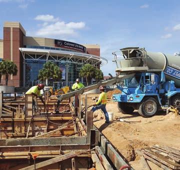
6 $188M SALES TAX COLLECTION TO DATE Greene Street Phase I-Innovista Project $137M TOTAL EXPENDITURES TO DATE North Springs Road and Risdon Way Intersection Improvement Project Blythewood Road Widening Public Meeting 4


7 SMALL LOCAL BUSINESS ENTERPRISES The purpose of the Small Local Business Enterprises (SLBE) Program is to provide a race- and gender-neutral procurement tool for the County to use in its efforts to ensure that all segments of its local business community have a reasonable and significant opportunity to participate in County contracts for construction, architectural and engineering services, professional services, 37 SLBE FIRMS ARE PARTICIPATING IN RICHLAND PENNY PROGRAM CONTRACTS 83 SLBE FIRMS HAVE BEEN CERTIFIED TO DATE $21.3M HAS BEEN AWARDED TO SLBE FIRMS TO DATE $13.0M HAS BEEN PAID TO SLBE FIRMS TO DATE non-professional services and commodities. 5
8 COMPLETED PROJECTS PROJECT Broad River Road and Rushmore Road Intersection Improvements Summit Parkway and Summit Ridge Drive Intersection Improvements North Springs and Risdon Way Intersection Improvements Kennerly/Coogler Intersection Improvements Riverbanks Zoo Pedestrian Bridge Lincoln Tunnel Greenway Greene Street Phase I-Innovista Project ACTIVE PROJECTS PROJECTS CURRENTLY IN CONSTRUCTION COST $1.04M $1.18M $1.95M $2.8M $2.77M $1.36M $17.4M Bluff Road Phase One Widening Hardscrabble Road Widening Shop Road Extension Phase 1 North Main Street Widening Resurfacing Package H (115 Roads) ACCOMPLISHMENTS 2016 TO DATE Projects Completed Project Public Meetings Speaker s Bureau Presentations Internship Positions Outside Funding Committed $6.9M $30M Design Contracts $4.1M $17M Construction Contracts $105M $135M PROJECTS IN DESIGN Project % Complete Clemson Road Widening 95% 2016 PDT Sidewalks 95% Broad River Road Neighborhood Improvements 95% Two Notch Road Bikeways 75% Bluff Road Widening Phase 2 70% Atlas Road Widening 70% Innovista - Greene Street Phase 2 70% Polo Road Sidewalk 70% Harrison Road Sidewalk 65% Percival Road Sidewalk 35% Sunset Boulevard Sidewalks 35% Gills Creek A Greenway 35% Pineview Road Widening 35% Shop Road Widening 30% Clemson Road and Sparkleberry Lane 30% Southeast Richland Neighborhood Improvements 30% Alpine Road Sidewalks 30% Blythewood Road Widening 25% Broad River Road Widening 25% Fort Jackson Boulevard Bikelanes 10% Candlewood Neighborhood Improvements 5% Decker Boulevard Neighborhood Improvements 5%


9 THE COMET In 2006, one of the most pressing issues for Richland County residents was the limited public transportation service available in the Midlands. After nearly five years of deliberation and study, Richland County voters approved the Transportation Penny Program in November In November 2013, the first revenues from the Penny started coming in and The COMET was able to make some much-needed changes. Improvements made possible by the Penny Program include: Adding staff to implement programs and services; Replacing the aging fleet with new vehicles, including propane-powered buses that burn clean fuel with lower costs; Placing more than 30 shelters and benches for passenger comfort; Adding 10 routes in order to reach parts of Richland County that had never before had service, and; Leveraging as much as $8M in federal funding for capital projects such as vehicles and shelters. 7


10 IS CATCHING ON! In November 2012, Richland County started the penny revenue. It s been about three years since the transportation penny took effect, and it s allowed us to make a positive difference ,498,818 BOARDINGS 187,221 61,557 SERVICE HOURS ,341,360 BOARDINGS PROPANE MINI-BUSES ADDED IN DART MINIVANS ADDED IN PROPANE MINI-BUSES ADDED IN 2014
11 FARE INFORMATION REGULAR HALF-PASS Regular Fare $1.50 Half-Fare* $0.75 All Day $3.00 $ Day $12.00 $ Day $14.00 $ Day $40.00 $20.00 * Half-fare is available to Senior Citizens (65+), persons with disability, Medicare card holders, veterans, and youths. ROUTES OFFERED NOV 2012 SEPT ,200 BUS STOP SIGNS WERE REPLACED WITH A.D.A. COMPLIANT SIGNAGE 32 TOTAL PROPANE POWERED VEHICLES IN SERVICE $7,589,687 FUNDS ADDED THROUGH FEDERAL MATCHING SINCE


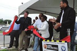
12 PUBLIC INVOLVEMENT Broad River Neighborhoods Improvement Project Public Meeting Blythewood Road Widening Public Meeting Residents, business owners and stakeholders played key roles in identifying transportation needs and priorities, and public participation continues to be an integral part in the implementation of the Richland County Transportation Penny Program. The use of traditional media, social media, mailings and a website are just a few techniques used by the Program Development Team (PDT) to ensure maximum participation from the public, which is critical to the success of the program. The public involvement process is modeled after and guided by Federal statutes and regulations of the Federal Highway Administration (FHWA) and South Carolina Department of Transportation (SCDOT) to ensure residents and businesses provide input in the development, design and delivery of Richland County transportation projects. Sidewalk Projects Public Meeting Clemson Road Widening Public Meeting 10


13 Broad River Neighborhoods Public Meeting Bluff Road Widening Phase 2 Public Meeting Clemson Road Widening Public Meeting In 2016, the Program Development Team coordinated a number of key public meetings and hearings for road widenings and neighborhood improvement plans approved by Richland County voters. The intent is simple: to provide free and open forums that help residents make sense of the many moving parts, give people an opportunity to raise questions and share concerns, and give people a clear understanding of the process. These efforts resulted in 2,200 residents being involved and 65,463 visitors to the Program website. SOCIAL MEDIA LIKE US ON FACEBOOK: FACEBOOK.COM/ RICHLANDPENNY FOLLOW US ON TWITTER: TWITTER.COM/ RICHLANDPENNY VIEW ONE OF OUR LATEST VIDEOS ON YOUTUBE: RICHLAND PENNY PROGRAM 11

14 ACCOMPLISHMENTS TO DATE 106 PROJECTS completed to date MITIGATION BANK More than $17M in design contracts awarded More than $135M in construction contracts awarded $30M in Federal / State / City funds added to program Annual County Transportation Improvement Program Pavement Management System with all 550 miles of county paved roads evaluated and prioritized $50M in construction contracts projected in 2017 The Mill Creek Mitigation Bank, located along Bluff Road near Congaree National Park in Lower Richland, was established by Richland County to offset the stream and wetlands impacts of transportation projects associated with the Penny Program. The 1,314-acre stream and wetland mitigation bank not only preserves wetlands, but includes substantial opportunities for wetlands restoration. This project is a huge step towards utilizing existing stream and wetland corridors in Richland County in a sustainable and economically productive manner BUILDING STRUCTURE AND MILL CREEK 2. DAM 3. MOIST SOIL MANAGEMENT AREA 4. DEAD RIVER CULVERT 5. CROSSING AT UT CONGAREE RIVER 7. WETLAND ENHANCEMENT (PLANTING) 8. ROAD WITH RISERS 9. PINE WETLANDS 10. PLUGGED DITCH 12

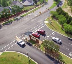
15 Summit Parkway and Summit Ridge Drive Intersection Improvement Project PROJECT SPOTLIGHTS The improvements made to the Summit Parkway and Summit Ridge Drive intersection include a dedicated right turn lane from Summit Parkway onto Summit Ridge and a dual left turn lane from Summit Ridge onto Summit Parkway. I m really pleased with the changes at that intersection. It used to get backed up so terribly because there wasn t a turning lane. Now, even if you get held up you can see the traffic moving; before it was a stand-still. - Stephanie Lawrence, Richland County resident We are now able to get buses in and out of traffic much more quickly. They get (to the schools) much more smoothly. - Jack Carter, chief operations officer of Richland School District Two 13


16 Transportation Program offers roundabout path to smoother travels PROJECT SPOTLIGHTS The Richland County Transportation Program funded a new roundabout, where Kennerly, Coogler and Steeple Ridge roads intersect at the entrance of the Ascot subdivision. A ceremonial groundbreaking for the $1.4 million project took place Sept. 15. Rep. Nathan Ballentine, South Carolina House of Representatives, notes, For years this has been one of the most dangerous intersections in our communities. While nothing prevents accidents more than driver awareness and caution, these improvements will provide additional safety measures that will ultimately save lives. We think it s great. The biggest problem we ve had, aside from getting in and out of the neighborhood, is with speeders. This will slow drivers down, says Rick Schmiedeker, Ascot resident and neighborhood board member. 14

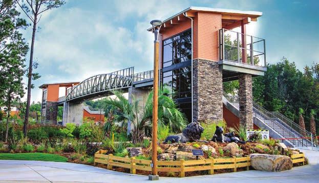
17 Riverbanks Zoo s new pedestrian bridge lauded for safety, convenience PROJECT SPOTLIGHTS Jessica Sandler brings her young children to Riverbanks Zoo quite often. At times, she would have to push a stroller and juggle bags, all while ushering her children over railroad tracks to get from a parking lot to the zoo. Never again. Thanks to the Richland County Transportation Program, Sandler and the 1 million other annual visitors to Riverbanks can now access the zoo more safely and conveniently. A 115-foot pedestrian bridge connects the recently added 500-car north parking lot to the zoo, spanning 25-feet over the CSX railroad tracks. The two-story Pedestrian Bridge was officially unveiled Sept. 7, 2016, during a ribbon cutting ceremony attended by approximately 100 people, including Richland County council members and Riverbanks commissioners. It s really nice. Now, if I have to park there (in the North lot) I can walk right over. - Jessica Sandler, Midlands resident 15


18 Lincoln Tunnel Greenway PROJECT SPOTLIGHTS The Lincoln Tunnel Greenway opened to Richland County citizens and visitors in the summer of The greenway, developed in partnership with Richland County, the City of Columbia and the South Carolina Department of Parks, Recreation and Tourism, is a 14-foot wide multi-use asphalt path that travels from Taylor Street, at Finlay Park, to Elmwood Avenue. 16


19 THE LOOK AHEAD GOING TO DESIGN IN 2017 SMITH/ROCKY BRANCH C GREENWAY BULL STREET/ELMWOOD AVENUE INTERSECTION CRANE CREEK NEIGHBORHOOD IMPROVEMENT GARNERS FERRY ROAD AND HARMON ROAD INTERSECTION NORTH SPRINGS ROAD AND HARRINGTON ROAD INTERSECTION SCREAMING EAGLE ROAD AND PERCIVAL ROAD INTERSECTION VARIOUS SIDEWALKS COUNTY ROAD RESURFACING COUNTY DIRT ROADS PAVING PROGRAM Mildred Street Sidewalk Project GOING TO CONSTRUCTION IN 2017 Riverbanks Zoo Pedestrian Bridge CLEMSON ROAD WIDENING FARROW ROAD/PISGAH CHURCH ROAD INTERSECTION CLEMSON ROAD/RHAME ROAD/NORTH SPRINGS ROAD INTERSECTION SOUTHEAST RICHLAND NEIGHBORHOOD IMPROVEMENTS (SERN) THREE RIVERS GREENWAY BROAD RIVER NEIGHBORHOOD IMPROVEMENT CANDLEWOOD NEIGHBORHOOD IMPROVEMENT VARIOUS SIDEWALKS COUNTY DIRT ROAD PAVING PROJECTS COUNTY ROADS RESURFACING Greene Street Phase I-Innovista Project 17


20 Richland County Transportation Program 2016 ANNUAL REPORT 201 Arbor Lake Drive Columbia, SC RCPenny
21 RICHLAND COUNTY TRANSPORTATION PROGRAM 2016 ANNUAL REPORT 5
Support the implementation of Cape Coral's Comprehensive Plan. Protect and utilize the unique natural resources in the City.
 7.0 OVERVIEW - RECOMMENDATIONS Chapter 7 The preparation of the Cape Coral Parks and Recreation Master Plan spanned a period of approximately 12 months. Plan preparation included the input of a wide range
We d like to thank you for attending this Wekiva Parkway Section 8 Preliminary Design Update hosted by the Florida Department of Transportation.
 We d like to thank you for attending this Wekiva Parkway Section 8 Preliminary Design Update hosted by the Florida Department of Transportation. We will provide you information on the overall project and
IMPLEMENTATION STRATEGIES. In This Chapter. Goals & Strategies 182 Project List 183 Future Land Use 186 CHAPTER 11 IMPLEMENTATION STRATEGIES
 In This Chapter Goals & Strategies 182 Project List 183 Future Land Use 186 11 IMPLEMENTATION STRATEGIES NORTH AUGUSTA, SC 2017 COMPREHENSIVE PLAN 179 Individual commitment to a group effort that is what
CHAPTER 7: Transportation, Mobility and Circulation
 AGLE AREA COMMUNITY Plan CHAPTER 7 CHAPTER 7: Transportation, Mobility and Circulation Transportation, Mobility and Circulation The purpose of the Transportation, Mobility and Circulation Chapter is to
The transportation system in a community is an
 7 TRANSPORTATION The transportation system in a community is an important factor contributing to the quality of life of the residents. Without a sound transportation system to bring both goods and patrons
WELCOME! 8 8:30 6: TH STREET IMPROVEMENTS. Open House. Presentation & Q&A
 WELCOME! 168 TH STREET IMPROVEMENTS 6:30 Open House 7 8 Presentation & Q&A 8 8:30 Open House WELCOME Todd Pfitzer City of Omaha Engineer Bob Stubbe City of Omaha Public Works Director Jon Meyer Project
SH 199 Corridor Master Plan. Community Meeting No. 2 May 31, 2017
 Community Meeting No. 2 May 31, 2017 Transportation Projects On or Near SH 199 SH 199 from 0.3 miles south of FM 1886 to south end of Lake Worth bridge Construct freeway mainlanes and frontage roads 10-Year
Pennsy Greenway Trail
 Town of Schererville Pennsy Greenway Trail DES. #s: 0401062, 1173595 & 1382661 Construction of Pennsy Greenway Trail beginning at Wilhelm Street and continuing northwest along the former Penn Central railroad
COASTAL REGION METROPOLITAN PLANNING ORGANIZATION APRIL 2012 MPO MEETINGS
 COASTAL REGION METROPOLITAN PLANNING ORGANIZATION APRIL 2012 MPO MEETINGS Agenda Item: Presenter: Summary: The project priorities for the CORE MPO s FY 2013-2016 Transportation Improvement Program (TIP)
The Illinois Department of Transportation and Lake County Division of Transportation. Route 173, including the Millburn Bypass
 The Illinois Department of Transportation and Lake County Division of Transportation welcome you to this Public Hearing for U.S. Route 45 from Illinois Route 132 to Illinois Route 173, including the Millburn
PROJECTS AND THE PUBLIC ART MASTER PLAN
 MEMO TO: PUBLIC ART STEERING COMMITTEE MEMBERS FROM: SHARI COOPER, DEVELOPMENT PROJECT COORDINATOR DATE: FEBRUARY 24, 2017 SUBJECT: AGENDA ITEM 5.A: PUBLIC ART PROJECT FOR 2017-18 BACKGROUND One of the
Transportation Committee
 Transportation Committee Business Item No. 2013-286SW Meeting date: October 14, 2013 For the Metropolitan Council meeting of October 16, 2013 Subject: Southwest Light Rail Transit (Green Line Extension):
TRANSPORTATION ELEMENT GOALS, OBJECTIVES, AND POLICIES
 TRANSPORTATION ELEMENT GOALS, OBJECTIVES, AND POLICIES GOAL 2 The City shall provide a safe, convenient, effective, and energy efficient multimodal transportation system which is coordinated with the Future
Fall 2017 Construction Update
 Fall 2017 Construction Update Ward 4 Southeast Engineering Department Riverwalk Red Multi-Use Trail Bridge Rehabilitation The Riverwalk Red Multi Use Trail Bridge was awarded to Cramer and Associates,
Overall Map. Chicago. St. Louis. Summit. Joliet. Dwight. Pontiac. Bloomington-Normal Lincoln. Springfield. Carlinville. Alton EXPERIENCE IT YOURSELF.
 Overall Map Summit Chicago Bloomington-Normal Lincoln New Station Planned New Station Planned Dwight Pontiac Joliet Pedestrian overpass and second platform planned Higher speed service began in this section
Capital Projects in and near Odenton Town Center
 Capital Projects in and near Odenton Town Center Map ID Anne Arundel County Department of Public Works This project provides for the design, right of way acquisition, and construction of approximately
East Corridor Final Environmental Impact Statement
 East Corridor Final Environmental Impact Statement Alternatives Considered Operating Plan The requirements for opening day operations versus year 2030 are based on ridership and operations. Opening day
The Lower SaLuda Greenway
 The Lower SaLuda Greenway InITIaTIve a FLourIShInG Greenway. a hub For economic GrowTh. a ConneCTIon BeTween CoMMunITIeS. In April 2017 the Michael J. Mungo Foundation and Lexington County commissioned
LOS ANGELES MISSION COLLEGE MASTER PLAN Master Plan DESIGN & DEVELOPMENT PRINCIPLES
 LOS ANGELES MISSION COLLEGE MASTER PLAN DESIGN & DEVELOPMENT PRINCIPLES 34 Quality Learning Along the Arroyo PROGRAM SUMMARY BY PROJECT The following are program summaries for each of the projects planned
Public input has been an important part of the plan development process.
 Lakewood s Comprehensive Plan recognizes that transportation helps shape the community, and that the way the community provides for the safe and efficient movement of people affects the character of the
Special Revenue Funds
 Special Revenue Funds Special Revenue Funds account for the proceeds of specific revenue sources (other than special assessments for major capital projects) that are legally restricted to expenditures
City of Meriden Harbor Brook Flood Control Project Overview
 City of Meriden Harbor Brook Flood Control Project Overview Updated August 2013 OVERVIEW The center of Meriden, including the HUB site is the low point of the town which is ringed by basalt ridges. Running
Capital Projects impacting Odenton Town Center
 Capital Projects impacting Odenton Town Center 1 2 E549700 W801600/ W801602 Anne Arundel County Department of Public Works Manor View Elementary School Transmission Main - MD 32 @ Meade Phase 2 $34,399,000
Berkshire Regional Planning Commission Clearinghouse Review Report
 August 19, 2013 SUBJECT: Reconstruction of Housatonic Street, Dalton, MA EOEA#: 15083 LOCATION: Dalton ESTIMATED COST: $8.1 million REVIEW TYPE: ENF PROPONENT: MassDOT and Town of Dalton COMMENTS DUE:
Engineering Department
 Engineering Department Department Mission It is the mission of the Engineering Department to protect and enhance the public health, safety and welfare by reviewing, inspecting and maintaining documentation
THREE-YEAR CAPITAL IMPROVEMENT PLAN FY
 THREE-YEAR CAPITAL IMPROVEMENT PLAN FY2016 2018 Annual CIP Development Process Public Works & Engineering Divisions Prepare List of Capital Needs and Recommended Deferred Maintenance Public Works & Engineering
BeltLine Corridor Environmental Study
 BeltLine Corridor Environmental Study Citywide Conversation on Transit and Trails April 2, 2009 Agenda & Introductions Introductions Environmental Study Process Overview of the BeltLine Project BeltLine
Mavis Road Class Environmental Assessment
 Mavis Road Class Environmental Assessment Public Information Centre #2 Wednesday November 9, 2016 6:00 to 8:00 p.m. Please sign in and complete a comment sheet Review the displays on your own or join in
New York Avenue Streetscape and Trail Project Public Meeting #1 Summary
 New York Avenue Streetscape and Trail Project Public Meeting #1 Summary I. King Jordan Student Academic Center (SAC) Gallaudet University, Washington, DC February 23, 2017 Table of Contents 1.0 Introduction...
Pinellas County Greenways
 Pinellas County Greenways USING GREENWAYS TO LINK OPEN SPACES The Florida Greenways Commission has defined a greenway as...a corridor of protected open space that is managed for conservation and/or recreation.
DRAFT SECTION 4(f) EVALUATION INTERSTATE 73 FEIS: I-95 to I-73/I-74 in North Carolina
 EVALUATION INTERSTATE 73 FEIS: I-95 to I-73/I-74 in North Carolina") DRAFT SECTION 4(f) EVALUATION INTERSTATE 73 FEIS: I-95 to I-73/I-74 in North Carolina 1.0 INTRODUCTION Section 4(f) of the Department of Transportation Act of 1966, 49 U.S.C. 303, requires that prior to
DRAFT SECTION 4(f) EVALUATION INTERSTATE 73 FEIS: I-95 to I-73/I-74 in North Carolina 1.0 INTRODUCTION Section 4(f) of the Department of Transportation Act of 1966, 49 U.S.C. 303, requires that prior to
TIRZ 17/Redevelopment Authority Capital Improvements Plan Projects
 Gessner Widening: T-1701 What: Widen the road from a six-lane divided boulevard to an eight-lane divided boulevard street section, increase turn lanes, update traffic signal system, improve drainage by
North Carolina Department of Transportation Project Development and Environmental Analysis Branch
 North Carolina Department of Transportation Project Development and Environmental Analysis Branch Citizens Informational Workshop I-85, from I-485 to NC 73 Mecklenburg and Cabarrus Counties October 30,
Courthouse Planning Area
 Courthouse Planning Area Current Reality The Courthouse Planning Area is the characterized by expansive suburbanscale residential areas as well as the community resource planned area of athletic, educational,
DRAFT Civic Center Station Area Plan. Executive Summary
 DRAFT Civic Center Station Area Plan Executive Summary This project is funded in part through the Metropolitan Transportation Commission s Station Area Planning Program. The preparation of this report
RESOLUTION NO. R Refining the route, profile and stations for the Downtown Redmond Link Extension
 RESOLUTION NO. R2018-32 Refining the route, profile and stations for the Downtown Redmond Link Extension MEETING: DATE: TYPE OF ACTION: STAFF CONTACT: Capital Committee Board PROPOSED ACTION 09/13/2018
Proposed FY 2004 TRANSPORTATION CAPITAL PROGRAM New Jersey Department of Transportation Projects
 30 130 Collingswood/Pennsauken ( B) 155C Vicinity of Cooper River Bridge at Park Drive to 200 feet north of PATCO Railroad Bridge This project may provide for the construction of a proposed new bridge
Secrest Short Cut and Monroe Expressway Small Area Plan AUGUST 29, 2018
 Secrest Short Cut and Monroe Expressway Small Area Plan AUGUST 29, 2018 Background and Process Monroe Expressway will be open by the end of 2018 Union County and Indian Trail identified a need to revisit
Hunt Highway CELESTE PEMBERTON, CFM, CPM PINAL COUNTY CARLOS SANCHEZ SORIA, PE T.Y. LIN INTERNATIONAL
 Hunt Highway CELESTE PEMBERTON, CFM, CPM PINAL COUNTY CARLOS SANCHEZ SORIA, PE T.Y. LIN INTERNATIONAL Agenda Design Concept Report Phase 1 Phase 2 Phase 3 Phase 4 Phase 5 Questions Design Concept Report
Southern Gateway Project and Public Green
 Southern Gateway Project and Public Green Transportation and Trinity River Project Committee May 23, 2016 Purpose of Presentation Provide the history and an overview of the Southern Gateway Project (SGP)
2017 Investment in Infrastructure Expo February 28, 2017 Jason Jonas, P.E. Public Works Director
 2017 Investment in Infrastructure Expo February 28, 2017 Jason Jonas, P.E. Public Works Director 1 Jefferson County, Missouri Road and Bridge Sales Tax: Jefferson County has a one-half cent sales tax that
OFFICIAL CONTROLS IMPLEMENTATION LEGAL REQUIREMENTS
 IMPLEMENTATION The objective of the Implementation component of the Comprehensive Plan is to identify the changes that need to be made to the official controls in order to be consistent with the Comprehensive
Ashland BRT Environmental Assessment: logos of CTA, CDOT, Chicago Department of Housing and Economic Development
 Ashland BRT Environmental Assessment: logos of CTA, CDOT, Chicago Department of Housing and Economic Development Overview The Chicago Transit Authority (CTA), in partnership with the Chicago Department
FY STATEWIDE TRANSPORTATION IMPROVEMENT PROGRAM New Jersey Department of Transportation Project Descriptions ($ millions)
") ADA Central, Contract 1 DBNUM: 15417 / UPC: 154170 This contract will bring projects into compliance with current ADA design requirements that could not be completed within original design or construction
ADA Central, Contract 1 DBNUM: 15417 / UPC: 154170 This contract will bring projects into compliance with current ADA design requirements that could not be completed within original design or construction
FDOT D4 Complete Streets
 FDOT D4 Complete Streets Context Sensitive Solutions Directs that complete street solutions will complement the context of the community. Collaborative approach to decision making, project development,
Public Meeting May 20, 2014
 Public Meeting May 20, 2014 Overview Study Purpose Study Area Overview Strategies Potential Opportunities Implementation and Discussion Skeo Solutions Raleigh Walkable Watershed Pilot 2 Purpose Develop
Transportation Projects Quarterly Report. Morrisville Planning Department May 22, 2018
 Transportation Projects Quarterly Report Morrisville Planning Department May 22, 2018 Transportation Improvements Most Common Ways the Town secures transportation improvements: 1. Development 2. Grant
Henderson County Project Prioritization Discussion
 French Broad River MPO Henderson County Project Prioritization Discussion A discussion on projects considered for MPO Local Input Points in the tier for P 5.0 French Broad River MPO 8-8-2018 INTRODUCTION
RECREATION AND OPEN SPACE ELEMENT GOALS, OBJECTIVES, AND POLICIES
 RECREATION AND OPEN SPACE ELEMENT GOALS, OBJECTIVES, AND POLICIES Goal 7 To provide park facilities, recreation programs, and open space resources that are safe, adequate, and accessible to all City residents,
Guiding Principles for the SR 520 Replacement Project
 Guiding Principles for the SR 520 Replacement Project Presentation to the Board of Regents Theresa Doherty Assistant Vice President for Regional Affairs May 18, 2006 F-14 The University of Washington is
List of Priority Projects
 List of Priority Projects Fiscal Years 2019-20 to 2023-24 June 25, 2018 Amended December 17, 2018 Metropolitan Transportation Planning Organization for the Gainesville Urbanized Area List of Priority
COASTAL CONSERVANCY. Staff Recommendation December 13, 2007 COASTAL TRAIL AT LAND S END. File No Project Manager: Joan Cardellino
 COASTAL CONSERVANCY Staff Recommendation December 13, 2007 COASTAL TRAIL AT LAND S END File No. 07-086-01 Project Manager: Joan Cardellino RECOMMENDED ACTION: Authorization to disburse up to eight hundred
TOWNSHIP OF HOWELL TOWNSHIP OF HOWELL ENGINEERING PROJECTS STATUS REPORT OCTOBER 19, Resurfacing of Aldrich Road West Contract # 11-06
 TOWNSHIP OF HOWELL DEPARTMENT OF COMMUNITY DEVELOPMENT & LAND USE DIVISION OF ENGINEERING 251 Preventorium Road Phone: (732) 938-4500 x2300 Post Office Box 580 Fax: (732) 919-1080 Howell, NJ 07731-0580
1.0 Circulation Element
 5/9/18 1.0 Circulation Element 1.1 Introduction As growth and development occur in Apache County, enhancements to its circulation system will be necessary. With time, more roads will be paved and air and
PUBLIC HEARING. Thursday, December 14, 2017 FDOT Urban Office 2198 Edison Avenue Jacksonville, FL 32204
 DISTRICT TWO PUBLIC HEARING I 10 (SR 8) from I 295 to I 95 Project Development & Environment Study Duval County, Florida Financial Project Number 213326 2 22 01 Efficient Transportation Decision Making
Public Hearing. Charlotte County-Punta Gorda MPO - Meeting Rooms A and B March 14, open house at 4 p.m., formal presentation at 5 p.m.
 Public Hearing Charlotte County-Punta Gorda MPO - Meeting Rooms A and B March 14, 2019 open house at 4 p.m., formal presentation at 5 p.m. Welcome to the Public Hearing for the Harborview Road (CR 776)
A Claustrophobic Corridor Grows Up
 A Claustrophobic Corridor Grows Up Presenters: Chris Bauserman, PE, PS Delaware County Engineer Jeff Griffin, PE Burgess & Niple, Inc. Brian Moore, PE Burgess & Niple, Inc. PROJECT OVERVIEW Sawmill Parkway
Finish Roanoke River Greenway from Green Hill Park to the Blue Ridge Parkway Regional Surface Transportation Program Application
 Finish Roanoke River Greenway from Green Hill Park to the Blue Ridge Parkway Regional Surface Transportation Program Application 1. Project Sponsors: City of Roanoke, City of Salem, Roanoke County, Town
BROOKHILL NEIGHBORHOOD MODEL ZONING MAP AMENDMENT PREFACE TO APPLICATION
 BROOKHILL NEIGHBORHOOD MODEL ZONING MAP AMENDMENT PREFACE TO APPLICATION June 15, 2015 Revised: August 1, 2016 I. VISION Brookhill is a proposed community based upon the principles of Albemarle County
Potential Green Infrastructure Strategies May 6, 2015 Workshop
 Potential Green Infrastructure Strategies May 6, 2015 Workshop Background The City of Cortland is developing the Tioughnioga Urban Headwaters Green Infrastructure Action Plan with funding from the National
Downtown River District
 City & Downtown Development Authority Partnership Infrastructure Analysis & Design Project Transportation & Utilities Fix Current Deficiencies Set the Stage for Future Infill & Redevelopment Who s Involved:
Highway 15 Project - Hutchinson
 Highway 15 Project - Hutchinson Agenda What are we going to talk about today? Goals and benefits of the project Details about the proposed work Project schedule and costs Any questions you may have about
AREA-WIDE PEDESTRIAN AND BICYCLE CIRCULATION
 OUSD LANEY CHILD CARE CENTER ART BUILDING LANEY COLLEGE BALL FIELDS PCCD OFFICES PERALTA PARK AQUATIC CENTER & ESTUARY PARK EDOFF MEMORIAL BANDSTAND SNOW PARK COURT HOUSE OAKLAND MUSEUM OAK ST AREA-WIDE
1. Parks & Recreation Neighborhood Parks Community Parks Special Use Sites 2. Open Space 3. Trails
 Appendix A: Park Classifications The intent of parks and recreation classifications is to aid in making acquisition and design decisions for park sites, facilities and the organization of recreation space
Knoxville Area Transit (KAT) Transit Development Plan Corridor Analysis
 Transit Development Plan Corridor Analysis") Knoxville Area Transit (KAT) Transit Development Plan Submitted to: Knoxville-Knox County Metropolitan Planning Commission Submitted by: PB Americas, Inc. Under contract to: The Corradino Group, Inc. October
Knoxville Area Transit (KAT) Transit Development Plan Submitted to: Knoxville-Knox County Metropolitan Planning Commission Submitted by: PB Americas, Inc. Under contract to: The Corradino Group, Inc. October
Pedestrian Bridge at Vermijo Avenue. Kathleen Krager June 13, 2016
 Pedestrian Bridge at Vermijo Avenue Kathleen Krager June 13, 2016 The Downtown Action Plan -1992- Proposes pedestrian crossing of the railroad at Vermijo Avenue Pikes Peak Greenway Master Plan -June
PROJECT STATEMENT LOCATION/DESIGN PUBLIC HEARING. 19 th AVENUE NORTH EXTENSION PROJECT FROM SPRINGDALE DRIVE TO NORTH 2 ND STREET/U.S.
 PROJECT STATEMENT LOCATION/DESIGN PUBLIC HEARING 19 th AVENUE NORTH EXTENSION PROJECT FROM SPRINGDALE DRIVE TO NORTH 2 ND STREET/U.S. 67 HEARING LOCATION: ERICKSEN COMMUNITY CENTER 1401 11 TH AVENUE NORTH
Mendota Heights 2040 Comprehensive Plan Draft Vers
 4 Parks and Trails The City of Mendota Heights boasts a variety of recreational and open space opportunities. Few cities can claim access to regional trails, riverside and lakeside parks, scenic bluffs
Southeast Extension to RidgeGate Parkway Scoping Booklet
 Southeast Extension to RidgeGate Parkway Scoping Booklet PUBLIC SCOPING MEETING SCHEDULE Public Scoping Meeting Wednesday, November 2, 2011 6:00pm to 7:30pm City of Lone Tree Recreation Center Willow Room
Shift Rapid Transit Public Participation Meeting May 3, 2017
 Shift Rapid Transit Public Participation Meeting May 3, 2017 Shift Rapid Transit Initiative Largest infrastructure project in the city s history. Rapid Transit initiative will transform London s public
SR 483 Clyde Morris Boulevard FDOT District 5
 This project occurs on a 3.0 mile section of SR 483 (Clyde Morris Blvd.) south of Beville Road (SR 400) to north of International Speedway Boulevard (SR 600). Ghyabi is providing project management and
Chapter 5: Recreation
 Chapter 5: Recreation Introduction and Setting Recreational opportunities within Nevada County are varied, ranging from public parks with intensively used active recreational facilities, to vast tracts
Planning Districts INTRODUCTION
 INTRODUCTION To facilitate detailed examination of development prospects for all areas of the community, Delano has been divided into 14 planning districts. The location of these planning districts is
PARTF Scoring System for Grants
 PARTF Scoring System for Grants The members of the N.C. Parks and Recreation Authority use the PARTF scoring system as one of several tools to select grant recipients. Please provide all of the information
FY STATEWIDE TRANSPORTATION IMPROVEMENT PROGRAM New Jersey Department of Transportation Projects
 69th Street Bridge 02311 02311 A grade separation at 69th Street would eliminate the current at-grade crossing which causes frequent automobile delays due to long freight trains moving through this area.
W&OD PARK MASTER PLAN. The City s Greenest Street. DRAFT W&OD Trail Master Plan v4.docx Page 1
 W&OD PARK MASTER PLAN Adopted XXX-XX-XXXX The City s Greenest Street DRAFT W&OD Trail Master Plan v4.docx Page 1 Introduction and Purpose The Washington & Old Dominion Railroad Regional Park (W&OD) (which
Kankakee River Bridge & Track Improvements Supplemental Environmental Assessment. May 5, 2016
 Kankakee River Bridge & Track Improvements Supplemental Environmental Assessment May 5, 2016 1 History: Chicago-St. Louis Corridor Since 1980 s IDOT has been looking at this corridor for high-speed service
Issues Requiring Future Study
 Issues Requiring Future Study Transportation planning is an ongoing process that tends to identify new issues as it finds solutions for others. Some issues are so complex that a solution to one problem
FY 2005 TRANSPORTATION CAPITAL PROGRAM
 Camden County Civic Center Access Study, Pennsauken 03340 This project will address operational and access improvements on Routes 30, 73 and 90 related to the Crossroads redevelopment project around the
Town of Cornelius Bond Update August, 2017
 Town of Cornelius Bond Update August, 2017 Referendum Results Roads, Intersections, & Sidewalks ($11.15 mil) Pass rate 81.38% in favor Parks and Recreation ($5.25 mil) Pass rate 72.09% in favor Town Center
2018 Primary Road Capital Improvement Plan (CIP) Projects Preservation / Structural Improvement, Non-motorized and Engineering Design Projects
 Projects Preservation / Structural Improvement, Non-motorized and Engineering Design Projects") 2018 Primary Road Capital Improvement Plan (CIP) Projects Preservation / Structural Improvement, Non-motorized and Engineering Design Projects Preservation / Structural Improvement Projects in 2018 Ravine
2018 Primary Road Capital Improvement Plan (CIP) Projects Preservation / Structural Improvement, Non-motorized and Engineering Design Projects Preservation / Structural Improvement Projects in 2018 Ravine
TOWN COUNCIL / PLANNING COMMISSION
 Workshop #3 TOWN COUNCIL / PLANNING COMMISSION January 20, 2011 Consultant Team In Attendance Tonight BMS Design Group Nevada City and San Francisco Michael Smiley, AICP, ASLA Partner-in-Charge Nancy L.
Meeting Purpose: Date and Time: Location: Attendance: Handouts:
 Meeting Purpose: Date and Time: Location: Attendance: Handouts: PA Turnpike / I-95 Interchange Project Design Advisory Committee (DAC)/Public Officials Meeting #8 April 12, 2012 at 1:30 p.m. Project Office,
495/MetroWest Development Compact Plan Citizen Planner Training Collaborative Conference. March 17, 2012
 495/MetroWest Development Compact Plan Citizen Planner Training Collaborative Conference March 17, 2012 Project Process Local and Regional Priority Areas Growth Scenarios Transportation Investment Categories
Access Management: An Overview
 Figures 1-5 Below Evolution of development along a highway. In the early stages, land along the road is used for farming with little traffic generated. As time passes, the highway corridor becomes a de
Welcome! MILLENNIUM LINE BROADWAY EXTENSION. Over the next 30 years, Metro Vancouver will welcome 1 million new residents and 600,000 new jobs.
 WELCOME Welcome! MILLENNIUM LINE BROADWAY EXTENSION Over the next 30 years, Metro Vancouver will welcome 1 million new residents and 600,000 new jobs. The Broadway Corridor is home to the second largest
3. VISION AND GOALS. Vision Statement. Goals, Objectives and Policies
 Vision Statement Queen Creek s interconnected network of parks, trails, open spaces and recreation opportunities provide safe and diverse activities and programs that sustain its unique, small town, equestrian
City of Plattsburgh DRI: Downtown Streetscapes & Riverfront Access. Downtown Streetscape and Riverfront Access Design
 City of Plattsburgh DRI: Downtown Streetscapes & Riverfront Access Welcome Thank you for coming this evening. Agenda PART I - Project Context The Downtown Revitalization Program Our DRI Projects Other
Value Engineering Seminar & Design for the Woodroffe Avenue Pedestrian Bridge November 24, 2009
 Value Engineering Seminar & Design for the Woodroffe Avenue Pedestrian Bridge November 24, 2009 Elizabeth Murphy, P.Eng. Sr. Project Manager, City of Ottawa Introduction Algonquin College and the City
UNIVERSITY OF MICHIGAN:
 Chapter Eight UNIVERSITY OF MICHIGAN: North Campus I. Introduction The University of Michigan currently owns approximately 800 acres of land in the northeast section of Ann Arbor. North Campus refers to
HILLSBOROUGH COUNTY Greenways and Trails Plan Update. Executive Summary. Date
 HILLSBOROUGH COUNTY Greenways and Trails Plan Update Executive Summary Date PURPOSE AND PROJECT OVERVIEW The Hillsborough County Greenways Master Plan (1995) and the City of Tampa s Greenways and Trails
HOLLERING PLACE MASER PLAN Concept for Development
 HOLLERING PLACE MASER PLAN Concept for Development Current Status of the Historic Hollering Place Development Project The city did not receive a responsive proposal for the Historic Hollering Place Development
Construction Engineering & Inspection Services Transit Bus Stop Infrastructure for the Broward County Transit Division (BCT)
") Construction Engineering & Inspection Services Transit Bus Stop Infrastructure for the Broward County Transit Division (BCT) 1 Firm Overview 2 We are a well established multi disciplinary firm that has
Construction Engineering & Inspection Services Transit Bus Stop Infrastructure for the Broward County Transit Division (BCT) 1 Firm Overview 2 We are a well established multi disciplinary firm that has
Comprehensive Development Guide
 INDUSTRIAL ELEMENT Comprehensive Development Guide 1 Industrial Element 7.1 Hardin County Industrial Overview BG PKWY Fort Knox Industrial Corridor Comprised of 11 parcels totaling 720 acres of land 68
ROUND ONE PROJECTS. Capital Grants 18 DELAWARE VALLEY REGIONAL PLANNING COMMISSION
 ROUND ONE PROJECTS DVRPC awarded the first round Take Me to the River grants in 2008 (see Figure 5 for project locations). The 13 projects selected were chosen based on their ability to reconnect citizens
Clay County Comprehensive Plan
 2011-2021 Clay County Comprehensive Plan Chapter 6: Transportation Clay County Comprehensive Plan Transportation Existing Transportation Network A balanced transportation network provides a safe and efficient
implementation10 Village of Greendale Comprehensive Plan: Greendale, Wisconsin. Revisiting a Greenbelt Community
 implementation10 Village of Greendale Comprehensive Plan: 2010 - Village of Greendale Comprehensive Plan: 2010 - Implementation The recommendations of this Plan must be implemented by the Village of Greendale,
University of the District of Columbia Van Ness Campus Master Plan Community Open House 3. December 8, 2010
 University of the District of Columbia Van Ness Campus Master Plan Open House 3 December 8, 2010 Introductions Sequence of Work: Campus Master Plan BEGIN: INTRODUCE AND START WORK Project Initiation Team
DEPARTMENT SUMMARY. Departmental Relationship to City Council Goals: Support and Promote the Local Economy
 Public Works DEPARTMENT SUMMARY Public Works Mission Statement The Department of Public Works is the caretaker of the community's infrastructure and a direct provider of sewer and refuse utility services
Longmeadow Parkway Fox River Bridge Corridor. August 6, 2015
 Longmeadow Parkway Fox River Bridge Corridor August 6, 2015 Longmeadow Parkway Bridge Corridor 5.6 miles from Huntley Road to IL 62 Unique municipal/county/state/federal partnership Links Randall Road