Marina Shores Village Project. March 5, 2003 Page 5-1. This EIR chapter identifies potential visual impacts that may result from implementation of the
|
|
|
- Lambert Andrews
- 5 years ago
- Views:
Transcription
1 March 5, 2003 Page VISUAL FACTORS This EIR chapter identifies potential visual impacts that may result from implementation of the proposed project. The analyses and descriptions in this chapter were formulated by the EIR consulting urban designer, Bottomley Design & Planning. The chapter describes the visual context of the project site and identifies relevant policies from the Redwood City Strategic General Plan, Redwood City Zoning Ordinance, and Redwood City Planning Division Urban Design Guidelines. The chapter also includes an assessment of viewshed impacts based on analysis of before and after visual simulations produced from key vantage points by the EIR visual simulation consultants, Environmental Vision. Mitigation measures are identified for potentially significant adverse visual impacts, keyed to the adopted City policies identified in section 5.2 (Pertinent Plans and Policies) and the CEQA-based significance criteria identified in subsection (Significance Criteria). The is currently in the process of preparing a Bayfront Study that discusses new land use, urban design, and circulation guidelines for the project site. The Bayfront Study will help define and promote the community's vision for this unique portion of Redwood City. The study will specifically address issues of building height and architectural character. 5.1 SETTING Visual Quality of the Site (a) Existing Structures and Uses. The site is comprised of two distinct and separate properties: the southern Peninsula Marina property and the northern Pete s Harbor property. These properties are separated by the Bair Island Marina, the adjacent "Villas at Bair Island" apartments, and an 80-foot-wide PG&E easement over U.S. Fish and Wildlife Service (USFWS) land. (1) Peninsula Marina Property. The Peninsula Marina property currently consists of three distinct subareas; north, central, and south (see Figure 3.3 in chapter 3, Project Description). The north subarea of the property is the former marina. The marina docks, slips, and pilings were removed in November 2001, leaving approximately 14.1 acres of open water, riprap/vegetated banks, and an abandoned road and parking area around the marina s perimeter. Along the Bair Island Road frontage there are a few evergreen trees, approximately 10 to 15 feet tall. The central subarea of the Peninsula Marina property contains one 2-story and four 3-story
2 March 5, 2003 Page 5-2 commercial buildings that overlook the former marina. These buildings are bordered on the south and east by a 754-space surface parking lot. The buildings are visible from the surrounding areas and have a nautical or Cape Cod theme consisting of grey clapboard with lighter trim and pitched roofs. Windows are recessed under pitched roof overhangs. There is minimal perimeter landscaping around the parking lot and buildings. The project site is approximately ten feet above Bair Island Road in this area, with a fairly steep slope topped by a row of evergreen trees about 15 feet tall. In the south subarea of the Peninsula Marina property, the land is vacant, disturbed, and overgrown. This area is basically flat and lies at approximately the same elevation as Bair Island Road and slightly below the elevated adjacent U.S. 101 freeway (Highway 101). Informal paths cross the area from the Redwood Creek pedestrian bridge. (2) Pete's Harbor Property (Inner and Outer). The Inner Pete s Harbor property consists of a variety of uses surrounding an active approximately 2.9-acre/116-slip marina. From the Uccelli Boulevard approach, the appearance is somewhat cluttered and disorganized. There are several visually unrelated buildings, including a one-story clapboard residence surrounded by a fence and metal storage structures, a two-story wood-shingled restaurant/harbor master office, wooden outbuildings including the marina restrooms and a kiosk, a metal shed R.V. repair shop, and a variety of metal shipping containers and prefabricated storage sheds. There are also parked cars, boats, trailers, and trucks. The property is haphazardly landscaped, with palm trees, some top-of-bank ornamental plantings of perennials, shrubs and small trees, some weed and ice plant covered banks, and miscellaneous windbreak plantings of small evergreen trees and shrubs. The Outer Pete's Harbor property includes a 147-slip marina. (b) Existing Visual Character. The two properties of the project site are physically and visually separate, and distinct in character. The Peninsula Marina property is a coherent development in terms of building style, function, and layout. Pete s Harbor has an eclectic, somewhat random appearance that has evolved over time. Open water space is a central feature of each property, and waterways surround much of the site. However, the marinas are not visible from Bair Island Road or from much of the project site itself, although sailboat masts are visible in the active Pete's Harbor marina. Redwood Creek is not visible from the interior portions of the site. Smith and Steinberger Sloughs are visible north of the Marina Pointe townhouses, which are located across Bair Island Road, west of the project site Character of the Project Vicinity (a) Overall Character of the Redwood City Bayfront Area. The visual quality of the Redwood City Bayfront Area is characterized by open and expansive views of horizon, sky, and the hills surrounding South San Francisco Bay. The viewshed extends from the Peninsula hills to the west; to Redwood Shores, Foster City and the San Mateo Bridge to the north; to the East Bay hills to the east; and to the Dumbarton Bridge and beyond to the south. Throughout the
3 March 5, 2003 Page 5-3 Bayfront Area, shorelines and open inland areas provide views to marshlands, sloughs, and waterways. From many locations where water is not directly visible, the masts of docked or passing sailboats are visible indicators of the active waterways that are central to the Bayfront character. For most of the Bayfront Area, including the project site, the foreground is defined by the height of mature trees, which is approximately 50 feet. Most existing development within the area is below or near this height, creating continuity of horizon that allows for distant views from surrounding areas. (b) Adjacent Visual Features. The following visual features are adjacent to the project site: (1) East Bayshore Road. Vehicular access to the project site is from the Whipple Avenue interchange at Highway 101 via East Bayshore Road. East Bayshore Road is a narrow frontage road that parallels Highway 101 and is separated by a chain-link topped K-rail. Along the north street frontage there are one-story buildings containing industrial and auto sales uses, and a 12- screen cinema complex with an extensive parking lot. Existing structures--metal shed buildings, glass-fronted auto showrooms and tilt-ups--are not consistent in architectural style, orientation, or relation to the street frontage. Parking lots, including car sales lots, dominate much of the frontage. Landscaping is intermittent. (2) Bair Island Road. Across Bair Island Road from the southern end of site are one-story tiltup buildings, surface parking, and the four-story Bayport Marina Plaza, a concrete block office building. This building is the tallest occupied structure in the immediate vicinity, and is located across from the Peninsula Marina office cluster. Marina Pointe, a compact development of twostory Mediterranean-style townhouses, is located just north of the Bayport Marina Plaza office building. Buildings are earth-toned stucco with shingled roofs, front porches, and perimeter landscaping. (3) Gap Area. Separating the project site properties is an approximately 80-foot-wide swath of USFWS land on which Pacific Gas & Electric (PG&E ) towers and overhead transmission lines are located. The approximately 204-foot-tall towers are the most prominent visual structures in the area; however, they are open-frame steel structures that do not block views. A parking lot for the Bair Island Wildlife Refuge occupies the western end of the USFWS land, while the eastern end remains an undeveloped field. Adjacent to the USFWS parcel are the "Villas at Bair Island," a marina/apartment complex. The buildings are four stories with housing above ground-level parking garages. The buildings are Mediterranean in style, with varied earth tone stucco facades articulated with balconies, arched openings, tile roofs, and varied roof lines. This high-density development (approximately 30 residential units per acre) is visually prominent from adjacent sites. (4) Surrounding Shorelines. The Pete s Harbor property is surrounded by water on the west, north, and east. PG&E transmission towers and lines run north past the property s western edge, across the tip of Bair Island. The Bair Island Wildlife Refuge, part of the Don Edwards
4 March 5, 2003 Page 5-4 San Francisco Bay National Wildlife Refuge, is located across Steinberger and Smith Sloughs to the west. Marshlands and tidal plains offer unobstructed views to the north and west. Across Redwood Creek to the east is Seaport Center, an office park of two- and three-story buildings that are composed primarily of tinted glass and concrete with flat roofs. There is mature landscaping and a perimeter jogging/bike path along the Seaport Center creek bank. Across Redwood Creek from the Peninsula Marina property are vessels moored at Docktown Marina. The boats of Docktown are a varied collection of traditional houseboats, sailboats, cruisers, floating cabins, and barges. Beyond Docktown Marina, the sand and gravel mounds and industrial machinery of Granite Rock company are visible. (5) U.S U.S. 101 (Highway 101) is adjacent to the southern tip of the project site. The highway is approximately 160 feet wide and is slightly elevated above the site as it crosses Redwood Creek. Across the highway south of the project site are one- to four-story office buildings. The tallest is a five-story office building at Walnut Street, about 1,000 feet south of the project site. (c) Outer Seaport Boulevard. Farther east and northeast of the project site, the Port of Redwood City and its related industrial features dominate the landscape, including large storage tanks and silos, sand and gravel piles, and loading facilities. The tallest occupied structures are the five- and six-story glass and steel office buildings of the Pacific Shores Center at the east end of Seaport Boulevard. The tallest unoccupied structures are the storage silos on the RMC site at the northern tip of Seaport Boulevard next to Pacific Shores Views of the Project Site from Surrounding Areas The Pete s Harbor property is surrounded on three sides by public waterways and shorelines, and is directly visible from these locations. The public trails and pedestrian paths of the Bair Island Wildlife Refuge and Seaport Center offer direct views of the Pete's Harbor property. The property is also directly visible from the Seaport Center s creekside office buildings, the "Villas at Bair Island," and a number of the Marina Pointe townhouses. The Peninsula Marina property is visible from Bair Island Road and the properties on its north street frontage, the PG&E easement/bair Island Wildlife Refuge parking lot, the "Villas at Bair Island," and Docktown. There are prominent views of the Peninsula Marina property from the Maple Street and Whipple Avenue overcrossings, which are major links between Downtown Redwood City and the greater Bayfront area. There is an unobstructed view of the Peninsula Marina property from both directions of U.S The entire project site is clearly visible from the hillsides of Redwood City and adjacent communities. The site is also visible from the public trails along the southern perimeter of the Redwood Shores neighborhood Outward Views from the Project Site
5 March 5, 2003 Page 5-5 From the Pete s Harbor property, views to the west and north include waterways and marshland, extending to the Peninsula hills, the large-scale office developments of Foster City and Redwood Shores, the San Mateo Bridge, and the East Bay hills. Views to the east and northeast across Redwood Creek are bounded by the Seaport Center office park. Views to the south are bounded by the "Villas at Bair Island." Views from the Peninsula Marina property are more limited. To the north, the PG&E towers are visually prominent but do not block views. The view is bounded by the "Villas at Bair Island" across the marina and USFWS land. Views to the south and east across Redwood Creek are to the vessels of Docktown. Granite Rock and the South Bay hills are visible beyond the marsh and slough. To the south, U.S. 101 dominates the foreground view, with mid-rise office buildings on the opposite side of the freeway and the Peninsula hills clearly visible beyond. Views to the west are bounded by low-rise buildings, parking lots, the Bayport Marina Plaza office building, and adjacent Marina Pointe townhouses. From the northeast corner of the Peninsula Marina property, there are views to the north and west of Bair Island Wildlife Refuge, the Peninsula hills, Foster City, Redwood Shores, the San Mateo Bridge, and the East Bay hills. 5.2 PERTINENT PLANS AND POLICIES Adopted plans and policies regarding visual quality include provisions of the Redwood City Strategic General Plan, the Redwood City Zoning Ordinance, and the Redwood City Planning Division Urban Design Guidelines. These provisions are identified below for consideration in evaluating the visual impacts of the project. In addition, as noted in the introduction to this chapter, the Bayfront Study, currently under preparation, is anticipated to contain specific recommendations and guidelines drafted specifically for the Bayfront Area, including the project site. When completed, these guidelines are intended to be directly pertinent to consideration and refinement of the proposed project design and its visual aspects Relevant Strategic General Plan Policies The Redwood City Strategic General Plan contains few policies related specifically to visual quality, though a number are related indirectly. These are contained in the Land Use, Open Space, and Conservation Elements, as listed below. Residential neighborhoods should be protected from the encroachment of incompatible activities or land uses which may have a negative impact on the residential living environment. (Land Use Policy L-1, page 6-5) Achieve and maintain a harmonious relationship between the natural environment and man s use of the land. (Open Space Objective 1, page 9-3) The City should preserve and enhance the natural terrain, vegetation, and beauty of
6 March 5, 2003 Page 5-6 Redwood City s various geographical areas. (Open Space Policy O-5, page 9-3) The City should preserve and enhance small parcels of open space in developed areas, wherever practical, especially in those neighborhoods with the greatest park deficiency. (Open Space Policy O-7, page 9-4) Environmentally unique open spaces such as San Francisco Bay, its tributaries, sloughs, and marshlands should be protected and enhanced for conservation and recreation purposes. (Conservation Policy C-3, page 10-4) The visual qualities of the community should be preserved and improved. (Conservation Policy C-7, page 10-4) Other Pertinent City-Adopted Policies In addition to the pertinent adopted General Plan policies listed above, the Redwood City City Council adopted the following more recent relevant policy on September 10, 2001: It is the policy of the that in the design of public and private projects, high priority be given to creating comfortable, enjoyable, and aesthetically pleasing public spaces Relevant Zoning Ordinance Provisions The Redwood City Zoning Ordinance contains regulations applicable to the site, including height regulations for the General Commercial-zoned Peninsula Marina property. It also contains standards to be specifically applied in the approval of Architectural Permit applications and the Precise Plan application, which would be required for the proposed project. Provisions relevant to visual factors are listed below. (a) Article 15--CG (General Commercial) District (Section Height Regulations): No structure shall exceed seventy-five (75) feet in height. (b) Article 45--Architectural Permits (Section Architectural Standards). In approving, conditionally approving, or denying any application for an Architectural Permit, the Zoning Administrator shall base his action upon the following factors: A. The existence of sufficient variety in the design of the structure and grounds to avoid monotony in the external appearance; B. The size and design of the structure shall be considered for the purpose of determining that the structure is in proportion to its building site and that it has a balance and unity among its external features so as to present a harmonious appearance;
7 March 5, 2003 Page 5-7 C. The extent to which the structure conforms to the general character of other structures in the vicinity insofar as the character can be ascertained and is found to be architecturally desirable; D. The extent to which excessive ornamentation is to be used and the extent to which temporary and second-hand materials, or materials which are imitative of other materials, are to be used; E. The extent to which natural features, including trees, shrubs, creeks, and rocks, and the natural grade of the site are to be retained; G. The reservation of landscaping areas for the purposes of separating or screening service and storage areas from the street and adjoining building sites, breaking up large expanses of paved areas, separating or screening parking lots from the street and adjoining buildings sites, and separating building areas from paved areas to provide access from buildings to open space areas; H. In the case of any commercial or industrial structure, the Zoning Administrator shall consider its proximity to any [residential] R District and shall consider the effect of the proposed structure upon the character and value of the adjacent R District area. (c) Planned Community District/Precise Plan. On December 2, 2002, the Redwood City City Council adopted Ordinance No , which amended the Zoning Ordinance to add the Planned Community District (P District), which "is designed to provide for those uses, or combination of uses, appropriately requiring flexibility under controlled conditions not otherwise attainable under other districts." A Precise Plan must be adopted simultaneously with a P District, but a project-specific Precise Plan cannot be adopted until the required CEQA documentation for the project (in this case, an EIR) is certified by the City Council. Therefore, the adoption of a Precise Plan for the proposed project can be decided upon by the City Council only after this EIR is certified Redwood City Planning Division Urban Design Guidelines (a) Introduction. The Redwood City Planning Division Urban Design Guidelines were drafted primarily for application in Downtown Redwood City; however, the text of the Guidelines does not limit their application solely to Downtown. The project site is one of a limited number of areas in Redwood City in which heights and density of development comparable to Downtown are contemplated. The Guidelines address a number of specific visual issues which apply to the proposed project, including sunlight and massing, setbacks, and landscape requirements. In summary, the Guidelines seek to improve the quality of individual projects, and this is controlled by the consideration of two important factors: Harmony, which looks at how a project relates to its environment...
8 March 5, 2003 Page 5-8 Compatibility, which is concerned with developing the most successful design for a given use... The following Guidelines are pertinent to consideration of the project: (b) Site Design and Project Orientation Guidelines: Projects shall be designed to enhance the particular characteristics of their environment and specific aspects of the visual quality of the community... Natural sunlight provisions shall be encouraged for all projects, particularly in the case of residential developments and public and private outdoor areas. Buildings shall be stepped back where bulk and building mass issues arise. Building facades shall be stepped back from the street... in order to avoid a slab-like appearance which generates strong wind conditions. Excessive density and bulk shall be disallowed for new developments... Bulk reduction in the form of additional setbacks at the upper floors of buildings should be integrated in the building design at stages appropriate to the overall mass of the building. - For structures over 30 and under 60 feet in height, a one-foot setback is recommended for every two feet in height above the third story or 30 feet, whichever is highest. - For structures over 60 feet in height, a one-foot setback is recommended for every foot above the sixth story, or 60 feet, whichever is highest. The bases of all buildings fronting on streets shall relate to the pedestrian scale by incorporating various amenities such as well-defined entrance areas, outdoor courtyards, public/private seating, and appropriate lighting conditions. The use of arcades, trellises, colonnades, landscaped pathways, judiciously located porches or porticos, and aesthetically designed entrance ways are also recommended for enhancing the streetscape. Parking facilities shall be less prominent than the principal structures which they serve, unless they are of exemplary architectural design quality. A sense of visual continuity with the adjacent structures, local streetscape, and general area shall be maintained. (c) Building Design Guidelines:
9 March 5, 2003 Page 5-9 New developments... shall be designed to relate to the general proportion, scale, and bulk of the surrounding area. (d) Landscaping Design Guidelines: The general environmental characteristics of the site shall be respected, including orientation, views, drainage, and other site-specific conditions which determine the selection of plant materials as well as the appropriate location of appurtenances (including open space areas, windows and door placements, and drainage lines). 5.3 IMPACTS AND MITIGATION MEASURES Significance Criteria Based on the CEQA Guidelines, the proposed project would be considered to have a significant impact on visual quality if it would: (1) Conflict with any applicable land use plan, policy, or regulation of the (including, but not limited to, the Redwood City Strategic General Plan and Zoning Ordinance), the Association of Bay Area Governments (ABAG), or the San Francisco Bay Conservation and Development Commission (BCDC), adopted for the purpose of avoiding or mitigating an environmental effect; 1 (2) Have a substantial adverse effect on a scenic vista; 2 (3) Substantially degrade the existing visual character or quality of the site and its surroundings; 3 (4) Require substantial terrain modifications; (5) Significantly alter public views or view corridors; 1 CEQA Guidelines, Appendix G, item IX(b). 2 CEQA Guidelines, Appendix G, item I(a). 3 CEQA Guidelines, Appendix G, item I(c).
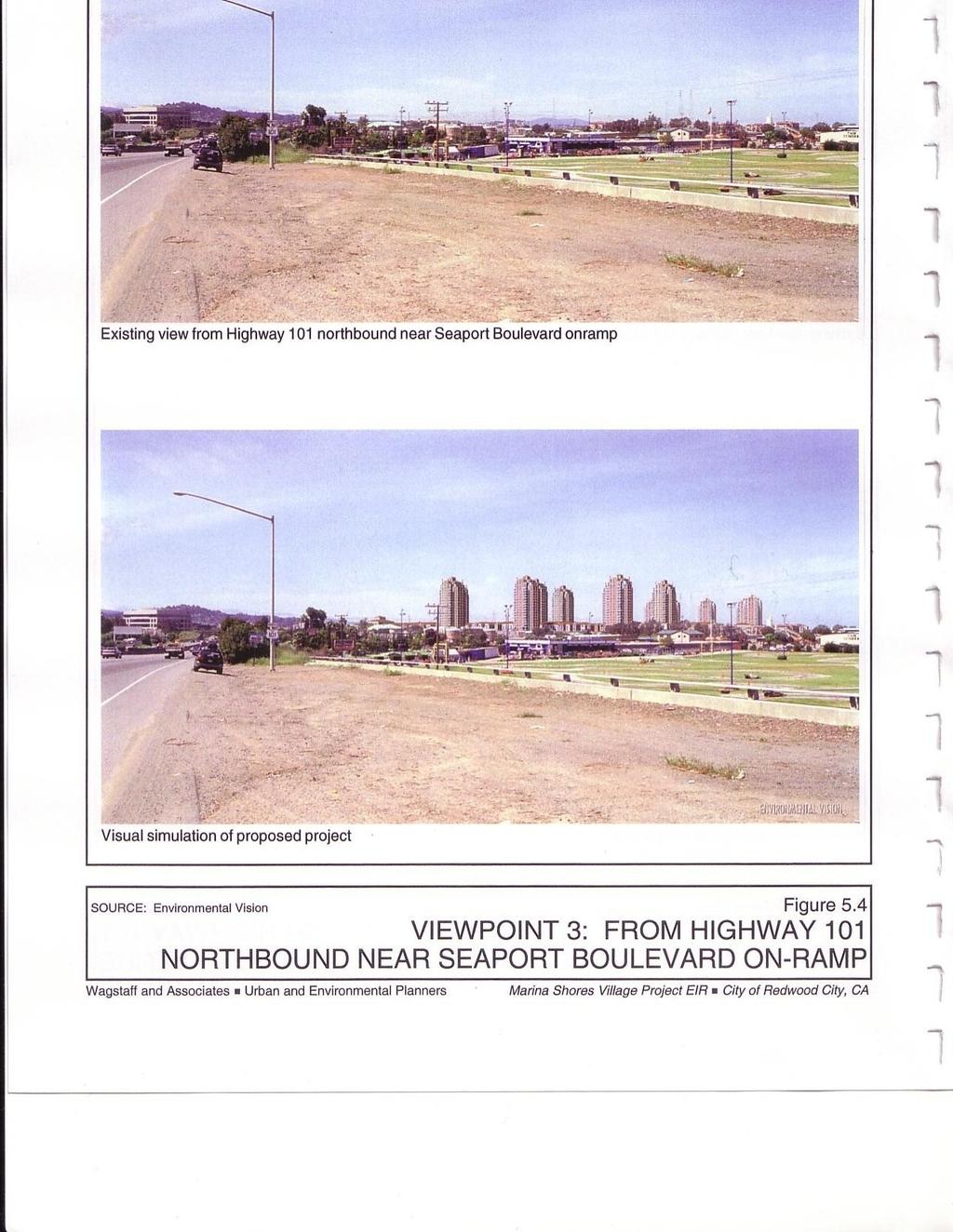
10 March 5, 2003 Page 5-10 (6) Create a new source of substantial light or glare which would adversely affect day or nighttime views in the area; 4 or (7) Result in a building scale that is not consistent with the surrounding community Visual Simulations Five viewpoints have been selected as representative of project visibility. They have been used to simulate the project in photo-montage form, using computer-generated visual simulation techniques. The simulations were independently prepared by Environmental Vision, EIR visual analysis and computer modeling consultants. Factors considered in selecting the viewpoints included relative project visibility, the number and sensitivity of viewers, and effects on views from public open spaces. The locations of the five viewpoints are identified on Figure 5.1, and described below: Viewpoint 1 (Figure 5.2): Bair Island Wildlife Refuge Public Trail. The trails on Bair Island are used by about 250,000 visitors annually. The view is from the trailhead, looking east. Viewpoint 2 (Figure 5.3): Highway 101 Southbound Near Whipple Avenue. Highway 101 is the Peninsula s major regional and local transportation route. Based on Caltrans' most recent counts (August 1998), approximately 116,500 vehicles per day pass this location. The view is to the southeast. Viewpoint 3 (Figure 5.4): Highway 101 Northbound at Seaport Boulevard. Based on Caltrans' most recent counts (August 1998), approximately 106,300 vehicles per day pass this location. The view is to the northeast. Viewpoint 4 (Figure 5.5): Maple Street/Highway 101 Overcrossing. Maple Street will become an important link between Downtown Redwood City and the Bayfront area. This viewpoint is a primary gateway to the Bayfront area in general and the project site specifically. The view is from the northbound lanes looking northwest. Viewpoint 5 (Figure 5.6): Edgewood Park. Edgewood Park is a popular public open space in the Redwood City hills. The view is also representative of views from a large portion of Redwood City s hillside residential areas. The view is looking northeast. Photographs were created by Environmental Vision using a 35 mm single lens reflex (SLR) camera with lenses ranging from 28 mm (Maple Street panorama) to 50 mm (Edgewood Park), and view angles ranging from 40 degrees (Edgewood Park) to 93 degrees (Maple Street panorama). 4 CEQA Guidelines, Appendix G, item I(d).
11
12
13
14

15

16
17 March 5, 2003 Page 5-17 Figures 5.2 through 5.6 illustrate before and after visual conditions. The simulations show the location, scale, and visual appearance of anticipated project buildings and landscape features based on an objective analytical and computer modeling process. The images are accurate within the constraints of available site and project data. The architectural details depicted in the simulations were derived from project plans and elevations provided by the project architects. At this initial Precise Plan/Planned Development Permit application stage, the proposed project design, including architectural details, is conceptual and may change over time Impacts and Mitigation Measures Impact 5-1: Project Inconsistency with City Height-Related Policies and Regulations. The City's General Plan states that "The visual qualities of the community should be preserved and improved" (Policy C-7). For General Commercial zoned properties such as the Peninsula Marina property, the City's Zoning Ordinance stipulates, "No structure shall exceed seventy-five (75) feet in height." For Residential Combining District zoned properties such as the Pete's Harbor property, the Zoning Ordinance stipulates that building heights shall be determined through the City's design review (Architectural Permit) process. With respect to both the Peninsula Marina and Pete's Harbor properties, Article 25 of the City's Municipal Code states that the approval, conditional approval, or denial of any application for an Architectural Permit (the project will require design review and Architectural Permit approval) shall be based on, among other listed factors, "The extent to which the structure conforms to the general character of other structures in the vicinity insofar as the character can be ascertained and is found to be architecturally desirable." The proposed project, as presented by the applicant for review in this EIR, would include 13 residential towers ranging from 240 to 260 feet in height, 12 mid-rise residential and two office buildings of 74 to 84 feet in height, and two-story townhouses and retail buildings approximately 24 feet in height. The proposed residential towers on the Peninsula Marina property, which would extend up to approximately 260 feet, would exceed the current 75-foot height limit by up to approximately 185 feet. Assuming the same 75-foot limitation is applied to the Pete's Harbor property in the interest of "conforming to the general character" of project structures on the Peninsula Marina property, the proposed residential towers on the Pete's Harbor property, which would extend to approximately 240 feet, would exceed this height by up to 165 feet. (continued)
18 March 5, 2003 Page 5-18 Impact 5-1 (continued) Unless the City approves the applicant-requested Precise Plan for the project site which permits these heights, the heights would be inconsistent with City policies and regulations. These heights would also result in a building scale that is not consistent with the existing surrounding community. These building heights would therefore represent a significant adverse visual impact (see criteria 1, 2, 5, and 7 in subsection 5.3.1, "Significance Criteria," above). Mitigation 5-1. Implement one of the following two alternative mitigations: Mitigation Alternative 5-1-1: Reduce the maximum project building heights on both properties to 75 feet, which would reduce this policy and regulatory consistency impact to a less-than-significant level. OR Mitigation Alternative 5-1-2: Adopt a Precise Plan for the project site that permits a building height in excess of 75 feet, and design the project accordingly. In conjunction with the new height allowance, formulate a set of Precise Plan Standards and Guidelines for the project site for adoption by the City's Architectural Review Committee, Planning Commission, and City Council that supersede current applicable City policies, standards, and guidelines pertaining to building form, height, shadow, conformity, setbacks, facades, etc., and permit current height limitations to be exceeded on the project site, provided that other specific provisions included in these Design Standards and Guidelines are incorporated into the project design to City (Architectural Review Committee) satisfaction. These measures would eliminate the project's policy and regulatory inconsistencies with respect to building height, but would not reduce the associated building scale inconsistencies to a less-than-significant level, and thus would result in a significant unavoidable visual impact (i.e., would require City adoption of a Statement of Overriding Considerations).
19 March 5, 2003 Page 5-19 Impact 5-2: Visual Impacts on Views and Vistas and on the Character of the Surrounding Area. Current development and vegetation form a base visual plane that is approximately 50 feet in height and merges with the horizon as seen from surrounding areas. Proposed project buildings would extend significantly above this plane, impacting the visual quality characteristic of the Bayfront Area. The proposed project, as presented by the applicant for review in this EIR, would include 13 residential towers ranging from 240 to 260 feet in height, 12 mid-rise residential and two office buildings of 74 to 84 feet in height, and two-story townhouses and retail buildings approximately 24 feet in height. The proposed residential towers would extend approximately 190 to 210 feet above the 50-foot base plane. The mid-rise elements of the project extend approximately 24 to 34 feet above the plane. A portion of sky and distant views would be blocked, shifting the focus of views from natural features to the project development in the foreground. As a result, the proposed project would have a substantial adverse effect on surrounding scenic vistas and would significantly alter public views and view corridors. The project would substantially alter the existing visual character of the surrounding area, which is currently characterized by open and expansive natural views. The project would diminish the quality of these views from numerous vantage points, including adjacent residential, commercial, and recreational areas, Highway 101, the Whipple Avenue and Maple Street overpasses, and the western hills. As a result, the project would have a significant visual impact on the character of the surrounding area (see criteria 1, 2, 3, 4, 5, and 7 in subsection 5.3.1, "Significance Criteria," above). The visual quality of the overall Bayfront Area is created by the openness associated with marshes, waterways, and the Bay beyond. Clear and unobstructed views, a broad visual horizon, and an uninterrupted expanse of sky are key elements. Current development and vegetation forms a base visual plane that is approximately 50 feet in height and merges with the horizon as seen from surrounding areas. Proposed project buildings would extend significantly above this plane, impacting the visual quality characteristic of the Bayfront Area. The project s visual effects are illustrated by the photo-simulations and described below. Viewpoint 1 (Figure 5.2): Bair Island Wildlife Refuge Public Trail. Project buildings would extend above the base plane. From this distance and perspective, the towers would appear to be approximately five times the height of the base plane. The view focus would be shifted from the distant horizon to the foreground development. Vegetation along Pete s Harbor would be replaced by the facades of high- and mid-rise buildings.
20 March 5, 2003 Page 5-20 Viewpoint 2 (Figure 5.3): Highway 101 Southbound Near Whipple Avenue. Project buildings would extend above the base plane. The towers would appear to be approximately three times the height of the base plane. Viewpoint 3 (Figure 5.4): Highway 101 Northbound at Seaport Boulevard. Project buildings would extend above the base plane. The towers would appear to be approximately three times the height of the base plane. Mid-rise and high-rise buildings would block views to the northern Peninsula hills, including views to San Bruno Mountain. Viewpoint 4 (Figure 5.5): Maple Street/Highway 101 Overcrossing. Project buildings would extend above the base plane. The towers would extend above the base plane and would appear to be approximately four times the height of the base plane. The base visual plane in this photo is created by existing trees and the Redwood City Police substation in the foreground. Viewpoint 5 (Figure 5.6): Edgewood Park. Project buildings would block views to portions of Redwood Creek, the Port of Redwood City, Seaport Center, portions of the Cargill Salt Ponds, and First and Westpoint Sloughs. Other than the two residences in the foreground, the project buildings would be the most prominent structures in the viewshed. From this distance and perspective, the project towers would appear to be approximately twice as tall as the RMC silos at the northerly end of Seaport Boulevard. According to calculations prepared by the project applicant in April 2002, building footprints would cover approximately 43 percent of the site. Over 70 percent of that area would consist of buildings between 74 and 260 feet in height. Illustrative project cross-sections have been prepared by the EIR urban design consultant, Bottomley Design & Planning, to illustrate project relationships to the surrounding creeks and sloughs, and to the existing 50-foot visual base plane (see Figures 5.7 through 5.9). As the project cross-sections and the visual simulations illustrate, the project buildings would block views of the sky and distant hills from surrounding areas. View corridors between residential towers would be narrow, and depending on the viewpoint, would disappear entirely, creating an appearance of solid building mass. The Redwood City Strategic General Plan Open Space Element (Policy O-5) states that the City should preserve and enhance the natural terrain, vegetation, and beauty of Redwood City s various geographical areas. Conservation Element Policy C-7 states that the visual qualities of the community should be preserved and improved. The Urban Design Guidelines state that projects shall be designed to enhance the particular characteristics of their environment and specific aspects of the visual quality of the community. The proposed project s intrusion above the existing visual horizon plane, and associated blocking of views,
21
22
23
24 March 5, 2003 Page 5-24 would detract from the visual qualities that characterize the Bayfront Area. Such conditions may be inconsistent with certain City policies and guidelines (see section 5.2, Pertinent Plans and Policies). The Redwood City Strategic General Plan Conservation Element (Policy C-3) states that environmentally unique open spaces such as San Francisco Bay, its tributaries, sloughs, and marshlands, should be protected and enhanced for conservation and recreation purposes. Publicly accessible waterways and waterfront trails border the project site. The cross-sections illustrated on Figure 5.9 indicate the change in visual enclosure that would occur along adjacent waterways and trails as a result of the project. In general, angles of enclosure along the project site would double (e.g., as indicated by Section B-B, increasing from approximately 15 degrees to 30 degrees). This enclosure would significantly impact the natural character and openness associated with adjacent trails and waterways. Mitigation 5-2. Implement the one following two alternative mitigations: Mitigation Alternative 5-2-1: Reduce project building heights to approximately 50 feet to merge with the visual base plane of the project site. At this height, buildings would not obstruct existing views of the sky and surrounding hills to a greater degree than existing buildings and vegetation. The buildings may be screened by perimeter trees, blending the project more sensitively into the natural Bayfront surroundings. (A similar condition currently exists along the Redwood Creek frontage of Seaport Center.) Also, set back project buildings from adjacent waterways and public trails to retain a more expansive open space character. The angle of enclosure created by new buildings generally should not exceed the angle created by existing trees and buildings which line Redwood Creek and Steinberger Slough. Implementation of these measures would reduce this impact (Visual Impacts on Views and Vistas and on the Character of the Surrounding Area) to a less-than-significant level. OR Mitigation Alternative 5-2-2: Implement Mitigation Alternative (adoption of a Precise Plan). Implementation of this measure would reduce the degree of project impacts on views and vistas and on the character of the surrounding area, but not to a less- than-significant level, and thus would result in a significant unavoidable visual impact (i.e., would require City adoption of a Statement of Overriding Considerations). Impact 5-3: General Visual Compatibility Impact. The project s architectural
25 March 5, 2003 Page 5-25 design concept is generally compatible with attractive new development in the immediate vicinity. However, the proposed project would substantially increase the height, mass, scale, and intensity of development on the site. The project s 13 residential towers, averaging 250 feet in height, would be over five times the height of the tallest structures in the immediate vicinity. The mid-rise residential and office buildings would be approximately two times the height of the tallest structures in the immediate vicinity. The project height would have a significant visual compatibility impact (see criteria 1 and 7 in subsection 5.3.1, "Significance Criteria," above). Existing buildings in the surrounding area are typically low-rise structures of four stories or less. Approaching the project site from the west, the only structures over two stories in height are the four-story Bayport Marina Plaza office building and the Marina Pointe townhouses, which are two stories over garages. The "Villas at Bair Island" apartments, located between Peninsula Marina and Pete's Harbor, are three stories over a ground floor parking podium. Across Redwood Creek are Docktown s one- and two-story houseboats and Seaport Center s two- and three-story offices. Across Highway 101, the tallest building adjacent to the highway is a five-story office building approximately 1,000 feet south of the project site. The only structures of any significant height in the Bayfront Area are the RMC storage silos, over a mile to the northeast. The largest and most recent development in the greater Bayfront Area is Pacific Shores Center, which is also over a mile from the project site and consists of fiveand six-story office buildings. The proposed project s 13 residential towers, averaging 250 feet in height, would be over five times the height of the Bayport Marina Plaza office building or the "Villas at Bair Island." The project's mid-rise residential and office buildings, at six to nine stories, would be approximately 1.5 to 2 times the height of these adjacent structures. Figures 5.7 and 5.9 indicate the relative heights of buildings in the immediate vicinity to the heights of the project buildings. The height, mass, scale, and intensity of proposed project is inconsistent with that of the surrounding community. The Redwood City Strategic General Plan Conservation Element (Policy C-7) states that the visual qualities of the community should be preserved and improved. The Peninsula Marina property is zoned CG--General Commercial. Zoning Ordinance section 15.5 states that no structure in an area zoned General Commercial shall exceed 75 feet in height. The Pete s Harbor property is zoned CG-R--General Commercial-Residential Combining, which does not have a maximum height limit for the residential portion of a parcel over 150 feet in average width and over 40,000 square feet in site area (e.g., the Pete's Harbor property), but which does have to meet the requirements for a Planned Development Permit. The Urban Design Guidelines (Site Design and Project Orientation Guidelines) state that a sense of visual continuity with the adjacent structures, local streetscape, and general area shall be maintained. The Guidelines (Building Design Guidelines) also state, New developments... shall be designed to relate to the general proportion, scale, and bulk of the surrounding area. The height, mass, scale, and intensity of project is not consistent with Policy C-7, Zoning
26 March 5, 2003 Page 5-26 Ordinance section 15.5, and the Urban Design Guidelines. The project s design and materials are visually compatible with the architectural quality of newer development in the Bayfront area, such as Pacific Shores and the "Villas at Bair Island." The project would be more visually compatible with new area development than the existing variety of storage structures and unrelated buildings at Pete s Harbor, or with the vacant land at the southern end of the project site. Mitigation 5-3. Implement one of the following two alternative mitigations: Mitigation Alternative 5-3-1: Reduce project building heights to a maximum of four stories and/or 50 feet, consistent with the general scale of adjacent and nearby development. Orient project buildings to relate to existing adjacent buildings and open spaces (also see Mitigation 5-5). Implementation of this measure would reduce general visual compatibility impact to a less-thansignificant level. OR Mitigation Alternative 5-3-2: Implement Mitigation Alternative (adoption of a Precise Plan). This mitigation would substantially reduce project visual compatibility impacts, but not to a less-than-significant level, and thus would result in a significant unavoidable visual impact (i.e., would require City adoption of a Statement of Overriding Considerations). Impact 5-4: Potential Light and Glare Impacts. Lighting in the outdoor spaces of the proposed project and interior lighting emanating from structures could create light and glare impacts on surrounding residences, commercial properties, and recreational areas. Additionally, daytime light reflection from the windows of the tower structures could create glare impacts on the surrounding areas. These effects may have a potentially significant impact (see criteria 1 and 6 in subsection 5.3.1, "Significance Criteria," above). The proposed project would contain roadways, circulation paths, and open spaces at ground level, and semi-private circulation, recreation, and open spaces at podium level (approximately 36 feet aboveground). Lighting of these outdoor spaces could create light and glare impacts on the adjacent residences (including Marina Pointe, the "Villas at Bair Island," and houseboats and live-aboards at Docktown and Outer Pete s Harbor), offices, commercial uses, and public recreational areas. Nighttime lighting emanating from the residential towers and mid-rise residential and office buildings could similarly create light and glare impacts on
27 March 5, 2003 Page 5-27 the same adjacent areas. Nighttime lighting would make the project s structures a prominent visual feature of the area, highly visible from nearby and distant residences and public areas. Nighttime lighting would illuminate the buildings above the visual base plane; interfere with dark sky views of sky, stars, and horizon; and emphasize the disparity in height and mass between project buildings and surrounding structures. These effects may have a potentially significant impact. Discussion under Impact 5-2 (Visual Impacts on Views and Vistas and on the Character of the Surrounding Area) and Impact 5-3 (General Visual Compatibility Impact) are relevant to potential light and glare impacts. Mitigation 5-4. Implement the following measures: Design project lighting to confine illumination to the project site, minimizing light spillage to adjacent residences, offices, commercial uses, and public open space and recreational areas. Use cut-off fixtures for outdoor areas. Provide structural or vegetative screening from sensitive adjacent uses. Reduce project building heights to approximately 50 feet, as noted in Mitigation Alternatives and 5-3-1, to minimize interference with dark sky views. If buildings taller than 50 feet are developed, some degree of tinting should be considered for glazing to reduce the nighttime visual impact of residential units. Implementation of these measures would reduce potential light and glare impacts to a less-than-significant level. Impact 5-5: Shadow Impacts. The project would cast substantial shadows on adjacent residential, commercial, office, and public waterfront areas during part of the year. Additionally, a significant portion of the buildings and open space within the project site would be shadowed throughout the year. Project buildings would cast shadows during morning hours September through March over portions of the Marina Pointe townhouses and Outer Pete s Harbor. During the longest shadow periods in December, project buildings would also cast shadows over portions of the Bair Island Wildlife Refuge in the morning; over the "Villas at Bair Island" and Bair Island Marina throughout the day; and over Redwood Creek and offices of Seaport Center during the afternoon. Portions of the proposed public park on the USFWS parcel would be in shadow throughout the afternoon hours of September through March.
28 March 5, 2003 Page 5-28 These shadowing effects, as illustrated by Figures 5.10 through 5.15 in this EIR, would have a significant visual impact (see criteria 1 and 3 in subsection 5.3.1, "Significance Criteria," above). Shadow analysis diagrams have been prepared by Environmental Vision using plans and elevations provided by the project architects. The longest and shortest shadow periods during the four seasons are illustrated in Figures 5.10 through Redwood City Strategic General Plan Land Use Element Policy L-1 states, Residential neighborhoods should be protected from... land uses which may have a negative impact on the residential living environment. The shadows cast by the proposed project would have a potentially significant impact on the residences surrounding the project site, substantially degrading the visual quality of the site and its surroundings. Within the project site, a significant portion of buildings and public open space would be in shadow throughout the year. During the longest shadow period, shown in the December diagrams (Figures 5.10 through 5.12), almost all open space would be shaded with the exception of the pedestrian path along Redwood Creek at the south end of the site. In fact, this section of shoreline path is the only open space within the project site that would not be in shade throughout much of the year. Public walkways within the project surround the proposed canals, which are oriented east-west. Adjacent towers and building masses would block southerly sun angles to these spaces. The effect from September through March (Figures 5.13 through 5.15) would be patches of light moving through dark open spaces over the course of the day, rather than patches of shadow moving through sunlit open spaces. The placement of trees as shown in the applicant s landscape plans (Figures 3.7 through 3.9 in chapter 3, Project Description) compounds the shading effect along a number of the public pathways and open spaces.
29
30
31
32
33
34
35 March 5, 2003 Page 5-29 Figure Project Shadow Patterns: Summer and Winter Mornings.
36 March 5, 2003 Page 5-35 Redwood City Strategic General Plan Open Space Element Policy O-7 states, The City should preserve and enhance small parcels of open space in developed areas... (emphasis added). The Urban Design Guidelines state that natural sunlight provisions shall be encouraged for all projects, particularly in the case of residential developments and public and private outdoor areas. The degree of shadowing in project open spaces would reduce rather than enhance the quality of open space and recreational opportunities within the project site, rendering such opportunities less attractive and functional, especially during winter months when solar access is most important. Mitigation 5-5. Implement one of the following two alternative mitigations: Mitigation Alternative 5-5-1: Reduce in height, step back, and/or relocate the towers within the proposed project to reduce shadow impacts on sensitive areas and uses, including perimeter waterways, recreational and public open spaces, residences, and internal project water areas and pedestrian courtyards. Minimize winter shadow impacts on Smith Slough/Outer Pete s Harbor, the Marina Pointe townhouses, and the "Villas at Bair Island"/Bair Island Marina. Implementation of this mitigation would reduce project shadow impacts to a less-than-significant level. OR Mitigation Alternative 5-5-2: Implement Mitigation Alternative (adoption of a Precise Plan). This mitigation would substantially reduce project visual compatibility impacts, but not to a less-than-significant level, and thus would result in a significant unavoidable visual impact (i.e., would require City adoption of a Statement of Overriding Considerations). Impact 5-6: Inconsistency with City Urban Design Objectives. The proposed project, as presented by the applicant for review in this EIR, would not create the onand off-site design relationships necessary for successful achievement of the City's urban design objectives (i.e., the Redwood City Planning Division Urban Design Guidelines). The proposed project buildings would not relate adequately to adjacent public spaces, including Bair Island Road, Redwood Creek, and perimeter public trails. On the current project plans, residential towers do not appear arranged to create a distinctive skyline composition, and they shade unique, publicly accessible open space areas. Open space and landscape design aspects of the project are at a preliminary stage, and the character and function of internal and perimeter project open spaces are not yet readily discernible. Nevertheless, the project would be
Nob Hill Pipeline Improvements Project EIR
 Section 3.1 Aesthetics This section addresses the visual aspects that may affect the views experienced by the public, including the potential to impact the existing character of each area that comprises
VISUAL RESOURCES 1. INTRODUCTION 2. EXISTING CONDITIONS. a. Visual Character
 IV.A VISUAL RESOURCES 1. INTRODUCTION This section addresses the potential changes in visual character that would result from implementation of the proposed Wilshire and La Brea Project. Also evaluated
4.1 AESTHETICS EXISTING ENVIRONMENTAL SETTING ALAMITOS BAY MARINA REHABILITATION PROJECT CITY OF LONG BEACH
 4.1 AESTHETICS This section provides a discussion of the existing visual and aesthetic resources on site and in the surrounding area as well as an analysis of potential impacts from implementation of the
Policies and Code Intent Sections Related to Town Center
 Policies and Code Intent Sections Related to Town Center The Town Center Vision is scattered throughout the Comprehensive Plan, development code and the 1994 Town Center Plan. What follows are sections
IV. ENVIRONMENTAL IMPACT ANALYSIS B. AESTHETICS 1. VIEWS
 IV. ENVIRONMENTAL IMPACT ANALYSIS B. AESTHETICS 1. VIEWS ENVIRONMENTAL SETTING Existing Visual Character Project Site The project site is located at 10250 Wilshire Boulevard in the Westwood community of
3.1 Aesthetics, Light, and Glare
 3.1 3.1.1 Introduction This section describes the existing aesthetics, light, and glare setting and potential effects from project implementation on visual resources and the site and its surroundings.
CHAPTER FIVE COMMUNITY DESIGN
 CHAPTER FIVE COMMUNITY DESIGN CHAPTER FIVE - COMMUNITY DESIGN Assumptions Frazier Park and Lebec have historically developed according to different patterns of spatial form. While both communities are
WATERFRONT PLACE CENTRAL MIXED USE REDEVELOPMENT PROJECT
 WATERFRONT PLACE CENTRAL MIXED USE REDEVELOPMENT PROJECT View Impact Analysis - Summary Narrative The view impact analysis conducted for the Waterfront Place Central mixed-use redevelopment project proposal
5.1.1 The streetscape along US Highway 64 (Brevard Road); and, The built environment within new residential developments; and,
; and, The built environment within new residential developments; and,") Article 5. Landscaping 5.1 Purpose The Town of Laurel Park s landscape standards are designed to create a beautiful, aesthetically pleasing built environment that will complement and enhance community
Article 5. Landscaping 5.1 Purpose The Town of Laurel Park s landscape standards are designed to create a beautiful, aesthetically pleasing built environment that will complement and enhance community
Urban Design Brief December 23, 2015 Southside Construction Group Official Plan & Zoning By-Law Amendment
 Urban Design Brief Proposed Official Plan & Zoning By-Law Amendment 3244, 3263 and 3274 Wonderland Road South Southside Group December 23, 2015 TABLE OF CONTENTS Page No. INTRODUCTION... 1 SECTION 1 LAND
The impacts examined herein take into account two attributes of aesthetic values:
 IV. ENVIRONMENTAL IMPACT ANALYSIS This section addresses the potential impacts to views and aesthetics as a result of the proposed Project at the Project Site and the development scenarios analyzed for
IV.B. VISUAL RESOURCES
 IV.B. VISUAL RESOURCES ENVIRONMENTAL SETTING Existing Visual Character Project Site The project site is located at 17331-17333 Tramonto Drive in the Pacific Palisades community of the City of Los Angeles
4.1 Aesthetics Setting. a. Visual Character
 Environmental Impact Analysis Aesthetics 4.1 Aesthetics This section analyzes the proposed Specific Plan s impacts related to aesthetics, including the existing visual character of and scenic views in
PROPOSED WATERFRONT DISTRICT DESIGN STANDARDS
 PROPOSED WATERFRONT DISTRICT DESIGN STANDARDS 20.25 DESIGN REVIEW. 20.25.080 WATERFRONT DISTRICT A. Purpose. This section is intended to implement The Waterfront District Subarea Plan by: 1. Creating a
WATERFRONT DISTRICT DESIGN STANDARDS
 WATERFRONT DISTRICT DESIGN STANDARDS 20.25.080 WATERFRONT DISTRICT A. Purpose. This section is intended to implement The Waterfront District Subarea Plan by: 1. Creating a safe, vibrant mixed-use urban
Residential Design Guidelines
 Residential Design Guidelines Single-Family Residential Design Guidelines Introduction These guidelines seek to provide property owners, designers and developers with a clear understanding of the City
4.1 AESTHETICS AND VISUAL QUALITY
 SCOPE AND METHODOLOGY 4.1 AESTHETICS AND VISUAL QUALITY This section evaluates the potential impacts to aesthetics and visual quality. Aesthetics refers to visual resources and the quality of what can
Resolution : Exhibit A. Downtown District Design Guidelines March 2003
 Resolution 03-011: Exhibit A Downtown District Design Guidelines March 2003 DOWNTOWN DISTRICT DESIGN GUIDELINES CITY OF SOUTHLAKE, TEXAS Adopted March 2003 1 DOWNTOWN DISTRICT DESIGN GUIDELINES Adopted
Buildings may be set back to create small plazas provided that these setbacks do not substantially disrupt the street wall s continuity.
 6-22 Community Design Street Walls and Street-front Setbacks The siting of buildings will play a critical role in establishing the character and sense of place for the District. Siting buildings at the
WINDSOR GLEN DESIGN GUIDELINES
 WINDSOR GLEN DESIGN GUIDELINES Adopted by Council, 2006 WINDSOR GLEN REDEVELOPMENT DESIGN GUIDELINES August 2006 1.0 Master Plan Organization For this area of the Coquitlam Town Centre, a mix of high,
Urban Design Brief to 1557 Gordon Street & 34 Lowes Road West
 Urban Design Brief 1533 to 1557 Gordon Street & 34 Lowes Road West Reid s Heritage Homes Ltd. & 883928 Ontario Ltd. and RHH Property Management Ltd. City of Guelph Zoning By-law Amendment November 2017
PROJECT SITE The Proposed Project includes the Allen and Pike Street malls between Delancey and South Streets (see Figure 2C-1).
.") Chapter 2, Section C: A. INTRODUCTION This chapter considers the potential of the proposed Reconstruction of the Allen and Pike Street Malls project to affect the urban design characteristics and visual
Chapter 2, Section C: A. INTRODUCTION This chapter considers the potential of the proposed Reconstruction of the Allen and Pike Street Malls project to affect the urban design characteristics and visual
GENERAL PLAN CONSISTENCY ANALYSIS
 GENERAL PLAN CONSISTENCY ANALYSIS Prepared by Planning Staff 10/28/2013 APPLICABLE GOALS, POLICIES AND PROGRAMS FROM the LAND USE CHAPTER Goal LU-1 Policy LU-1.1 Policy LU-1.2 Goal LU-2 Protect the character
5.8 Visual Resources and Aesthetic Qualities
 I-70 East Supplemental Draft EIS 5.8 Visual Resources and Aesthetic Qualities 5.8 Visual Resources and Aesthetic Qualities This section discusses the visual resources and aesthetic qualities of the study
Visual and Aesthetics
 Such a connection could accommodate timed transfers and improve connections between local transit service and Presidio Shuttle service. Level of Service The results of the analysis are provided on a route-by-route
4.0 AFFECTED ENVIRONMENT AND ENVIRONMENTAL CONSEQUENCES
 4.0 AFFECTED ENVIRONMENT AND ENVIRONMENTAL CONSEQUENCES The following sections discuss the impacts associated with environmental resources for the tunneling method Alternatives A and B. The construction
4.0 Design Guidelines For The Village Centre. South fields Community Architectural Design Guidelines Town of Caledon
 4.0 Design Guidelines For The Village Centre 4.0 Design Guidelines for the Village Centre The Village Centre is the focal point of the entire South Fields Community and is designed as a traditional commercial
THE PLANNING AREA 2.1 PLANNING AREA LOCATION
 2. The Planning Area Brisbane Baylands Specific Plan 21 2 THE PLANNING AREA 2.1 PLANNING AREA LOCATION The Baylands is located approximately midway between San Francisco s central business district and
3.0 URBAN DESIGN. December 6, OVERVIEW
 Urban Design 3.0 URBAN DESIGN December 6, 2007 3.1 OVERVIEW The highly urban character of Easton Place is defined by the overall design of the community. The following sections provide an overview of the
ELMVALE ACRES SHOPPING CENTRE MASTER PLAN
 ELMVALE ACRES SHOPPING CENTRE MASTER PLAN Contents 1.0 INTRODUCTION... 2 2.0 LOCATION... 2 3.0 EXISTING CONTEXT... 2 4.0 VISION & GUIDING PRINCIPLES... 2 5.0 LAND USE AND BUILT FORM... 4 5.1 St. Laurent
RZC Public View Corridors and Gateways
 RZC 21.42 Public View Corridors and Gateways 21.42.010 Purpose 21.42.020 Scope and Authority 21.42.030 Administration 21.42.040 Gateways Design 21.42.050 Unidentified Public Views 21.42.060 Identification
Section 3.16 Visual Quality
 Chapter 3 Affected Environment, Environmental Consequences, and Mitigation Measures Section 3.16 Visual Quality Introduction This section discusses existing conditions, effects and mitigation measures
B L A C K D I A M O N D D E S I G N G U I D E L I N E S for Multi-family Development
 B L A C K D I A M O N D D E S I G N G U I D E L I N E S for Multi-family Development Adopted June 18, 2009 This section of the Design and focuses on site planning and design guidance for new multi-family
IV. ENVIRONMENTAL IMPACT ANALYSIS B. AESTHETICS
 IV. ENVIRONMENTAL IMPACT ANALYSIS B. AESTHETICS INTRODUCTION This section evaluates the potential impacts of the Proposed Project on aesthetics, views and vistas, light and glare, and shade and shadows
4.8 LAND USE AND PLANNING
 4.8 LAND USE AND PLANNING 4.8.1 INTRODUCTION This section describes existing and planned land uses at the Hayward campus and analyzes the impact of implementation of the proposed Master Plan on land uses
Policy I-G-7: Public access to the Bay for the scenic enjoyment of the open water, sloughs, and marshes shall be protected.
 3.3 AESTHETICS Introduction This section describes the existing aesthetic resources and visual characteristics of the Project site and its immediate vicinity, along with existing plans and policies that
920 BAYSWATER AVENUE PROJECT
 920 BAYSWATER AVENUE PROJECT VISUAL ASSESSMENT Prepared for the City of Burlingame Prepared by Circlepoint 46 S First Street, San Jose, CA 95113 June 2018 This page intentionally left blank. 920 Bayswater
4.9 Mendocino Avenue Corridor Plan Design Guidelines
 4.9 Mendocino Avenue Corridor Plan Design Guidelines The Mendocino Avenue Corridor Plan addresses the area between College Avenue and Steele Lane. Mendocino Avenue is a busy arterial that runs parallel
Infill Residential Design Guidelines
 Infill Residential Design Guidelines Adopted March 23, 2004 Amended September 10, 2013 City of Orange Community Development Department Planning Division Phone: (714) 744-7220 Fax: (714) 744-7222 www.cityoforange.org
CHAPTER 10 AESTHETICS
 CHAPTER 10 AESTHETICS CHAPTER 10 AESTHETICS This section identifies and evaluates key visual resources in the project area to determine the degree of visual impact that would be attributable to the project.
Official Plan Review: Draft Built Form Policies
 PG.30.1 REPORT FOR ACTION Official Plan Review: Draft Built Form Policies Date: May 15, 2018 To: Planning and Growth Management Committee From: Chief Planner and Executive Director, City Planning Division
WEST LOOP DESIGN GUIDELINES CHECKLIST
 WEST LOOP DESIGN GUIDELINES CHECKLIST Section 1.0 General Strategies 1.1 DESIGN EXCELLENCE: ENCOURAGE HIGH QUALITY AND INNOVATIVE DESIGN OF NEW BUILDINGS WITHIN THE WEST LOOP WITHOUT BEING PRESCRIPTIVE
CHAPTER 3. Design Standards for Business, Commercial, Industrial, Recreational and Institutional Uses
 CHAPTER 3 Design Standards for Business, Commercial, Section Number Title Ordinance Number Date of Ordinance 16-3-1 Applicability 2006-11 2008-04 07-01-08 16-3-2 Uniform Standards for Architectural Design
URBAN DESIGN BRIEF. April FREEPORT Street TOWNHOUSES. 711 FREEPORT St., LONDON
 URBAN DESIGN BRIEF April 2013 FREEPORT Street TOWNHOUSES 711 FREEPORT St., LONDON TABLE OF CONTENTS 1.0 Land Use Planning Context...... pg. 1 1.1 Subject Lands... pg. 1 1.2 Proposed Development... pg.
Environmental Setting, Impacts, and Mitigation Measures
 CHAPTER 3 Environmental Setting, Impacts, and Mitigation Measures Format of the Environmental Analysis The assessment of each environmental resource discussed in this chapter includes the following: Environmental
3.10 LAND USE SETTING PROJECT SITE EXISTING LAND USE DESIGNATIONS AND ZONING. General Plan Land Use Designations.
 This section of the Draft EIR addresses the existing land uses on and adjacent to the project site and discusses the potential impacts of the proposed project on existing land uses. Key issues addressed
Site Planning. 1.0 Site Context. 2.0 Pedestrian Circulation Systems. Pag e 2-23
 The following photographs from throughout the country illustrate key urban design principles. Photographs are provided to illustrate the overall urban design concepts described in Chapter 1 of the Downtown
4.1 AESTHETICS. A. Regulatory Framework
 4.1 This section includes a description of the existing visual setting of the project site and an analysis of the effects the proposed project would have on aesthetics in the project vicinity. Aesthetics
4 January 11, 2012 Public Hearing APPLICANT:
 . 4 January 11, 2012 Public Hearing APPLICANT: MID-ATLANTIC AUTO PROPERTY OWNER: DZR, LLC STAFF PLANNER: Leslie Bonilla REQUEST: Conditional Use Permit (truck rental, automobile service, and automotive/bulk
DRAFT ENVIRONMENTAL IMPACT REPORT DEEP VALLEY DRIVE AND INDIAN PEAK ROAD MIXED-USE RESIDENTIAL PROJECT
 LSA ASSOCIATES, INC. JUNE 2012 SECTION 4.1 AESTHETICS DRAFT ENVIRONMENTAL IMPACT REPORT 4.1 AESTHETICS Introduction This section provides a discussion of the existing visual and aesthetic resources on
M i s s i o n B a y W a t e r f r o n t
 114 M i s s i o n B a y W a t e r f r o n t Character of the Area: The Mission Bay Waterfront extends from Pier 48 at China Basin Channel to 18th Street in the Central Basin. This area of the waterfront
IV. ENVIRONMENTAL IMPACT ANALYSIS
 IV. ENVIRONMENTAL IMPACT ANALYSIS IV. ENVIRONMENTAL IMPACT ANALYSIS A. AESTHETICS AND VIEWS 1. INTRODUCTION This section analyzes the potential impacts that could result from the proposed project with
Glenn Highway MP DSR. Landscape Narrative
 Glenn Highway MP 34-42 DSR Landscape Narrative Project Landscape Goals The Glenn Highway MP 34-42 Project extends through a variety of landscape types typical to the Matanuska-Susitna Valley. In general,
The Village. Chapter 3. Mixed Use Development Plan SPECIFIC PLAN
 The Village SPECIFIC PLAN Chapter 3 3.1 INTRODUCTION 3.1.1 Purpose This Chapter describes the development regulations applicable to the Mixed-Use and Transit Center Planning Areas. These form-based regulations
The Highway Overlay District applies to an area within the City of Papillion's zoning jurisdiction described as:
 ARTICLE XXVIII. HOD Highway Overlay District 205-164. Intent. The Highway Overlay District recognizes the strategic importance of the Highway 370 corridor as an entrance to Papillion from Interstate 80
VILLAGE OF SKOKIE Design Guidelines for Mixed-Use Districts NX Neighborhood Mixed-Use TX Transit Mixed-Use CX Core Mixed-Use
 VILLAGE OF SKOKIE Design Guidelines for Mixed-Use Districts NX Neighborhood Mixed-Use TX Transit Mixed-Use CX Core Mixed-Use TABLE OF CONTENTS CHAPTER 1 SITE DESIGN Purpose 1 CHAPTER 2 SITE DESIGN Streetscape
Section Three, Appendix 16C Medium Density Housing, Design Assessment Criteria (Residential 8A zone)
") APPENDIX 16C MEDIUM DENSITY HOUSING, DESIGN ASSESSMENT CRITERIA (RESIDENTIAL 8A ZONE) PURPOSE OF APPENDIX 16C (RESIDENTIAL 8A ZONE) In the Residential 8A Zone the following are defined as restricted discretionary
APPENDIX 16C MEDIUM DENSITY HOUSING, DESIGN ASSESSMENT CRITERIA (RESIDENTIAL 8A ZONE) PURPOSE OF APPENDIX 16C (RESIDENTIAL 8A ZONE) In the Residential 8A Zone the following are defined as restricted discretionary
Incentive Zoning Regulations Florida Municipal City of Orlando
 Topic: Resource Type: State: Jurisdiction Type: Municipality: Year (adopted, written, etc.): 2002 Community Type applicable to: Title: Incentive Zoning Regulations Florida Municipal City of Orlando Document
Design Guidelines Checklist
 Design Guidelines Checklist A quick reference to the City of Vista Design Guidelines City of Vista Community Development Department Planning Division 600 Eucalyptus Avenue Vista, CA 92084 760.639.6100
CENTERS AND CORRIDORS
 INITIAL DESIGN STANDARDS AND GUIDELINES for CENTERS AND CORRIDORS City of Spokane Planning Services Third Floor, City Hall 808 W. Spokane Falls Blvd. Spokane, WA 99201-3329 (509) 625-6300 www.spokaneplanning.org
CHAPTER 13 DESIGN GUIDELINES
 CHAPTER 13 DESIGN GUIDELINES Section 1300.00 Section 1300.01 Design Guidelines Purpose The purposes of this section are to: A. The purpose of this Section is to establish procedures and standards to serve
QUEEN-RIVER SECONDARY PLAN
 34 QUEEN-RIVER SECONDARY PLAN 34. QUEEN RIVER SECONDARY PLAN 1. INTRODUCTION The Queen-River area is approximately 6.4 hectares and is located at the eastern edge of the Downtown as shown on Map 34-1.
6.3 VISUAL RESOURCES. Landscape Character
 6.3 VISUAL RESOURCES 6.3.1 Affected Environment The DMR discussion is divided into two areas, DMR and Dillingham Trail, which would extend from SBMR to DMR. The ROI includes all areas within the line of
A. WHAT IS A GENERAL PLAN?
 I. Introduction A. WHAT IS A GENERAL PLAN? A general plan is the planning guideline for the future of a city. It contains goals and policies which regulate urban development, the protection of the natural
ATTACHMENT A. SILVERDALE DESIGN STANDARDS Amendments to the Waaga Way Town Center Chapter
 ATTACHMENT A SILVERDALE DESIGN STANDARDS Amendments to the Waaga Way Town Center Chapter Chapter 10. Waaga Way Town Center 10.1 Physical Identity Elements & Opportunities The Waaga Way Town Center includes
I. VISUAL/AESTHETICS/NEIGHBORHOOD CHARACTER. b. Existing Conditions Views from Kimball Avenue
 I. VISUAL/AESTHETICS/NEIGHBORHOOD CHARACTER 1. Existing Conditions a. View Of The Site From Area Roads Figures IV.I-2, I-3 and I-4 depict existing views from the Cross County Parkway, Central Park Avenue,
APPENDIX C. Architectural and Environmental Design Standards. Environmentally sensitive areas should be protected.
 APPENDIX C Architectural and Environmental Design Standards Environmentally Sensitive Areas Goal A. Environmentally sensitive areas should be protected. Development, such as roads, houses, and other structures,
IV. ENVIRONMENTAL IMPACT ANALYSIS B. AESTHETICS 1. SHADE/SHADOW
 IV. ENVIRONMENTAL IMPACT ANALYSIS B. AESTHETICS 1. SHADE/SHADOW ENVIRONMENTAL SETTING The issue of shade and shadow pertains to the blockage of direct sunlight by onsite buildings, which affect adjacent
6 May 14, 2014 Public Hearing
 6 May 14, 2014 Public Hearing APPLICANT: MICHAEL D. SIFEN, INC. PROPERTY OWNER: GEORGE STREET CORP. STAFF PLANNER: Stephen J. White REQUEST: Conditional Use Permit (Mini-Warehouse / Self Storage) ADDRESS
Urban Design Brief Proposed Residential Development 5219 Upper Middle Road City of Burlington
 Urban Design Brief Proposed Residential Development 5219 Upper Middle Road City of Burlington Prepared by Weston Consulting Prepared for BLOOMFIELD DEVELOPMENT INC. Date: March 2017 Table of Contents 1.
5.1 AESTHETICS AND VISUAL RESOURCES Physical Setting
 5.1 AESTHETICS AND VISUAL RESOURCES 5.1.1 Physical Setting Aesthetic values are an important aspect in establishing the identity, sense of place, and quality of life in a community. Natural features in
4 LAND USE DESIGNATIONS
 4 LAND USE DESIGNATIONS Chapter 4 describes the land use designations and densities that will implement the development vision for North Burlingame outlined in Chapter 3. Land use densities are described
OCEAN BOULEVARD PLANNED DEVELOPMENT DISTRICT (PD-5)
") OCEAN BOULEVARD PLANNED DEVELOPMENT DISTRICT (PD-5) Ordinance History: C-5562, 1982 The intent of the Planned Development Plan is to provide a framework to guide new development in a way that is sensitive
OCEAN BOULEVARD PLANNED DEVELOPMENT DISTRICT (PD-5) Ordinance History: C-5562, 1982 The intent of the Planned Development Plan is to provide a framework to guide new development in a way that is sensitive
DRAFT. October Wheaton. Design Guidelines
 October 2011 DRAFT Wheaton Design Guidelines 2 Draft - Design Guidelines - Wheaton Sector Plan Contents 04 Section 1: Introduction 06 Section 2: Context 08 Section 3: Design Guidelines 09 Goal 1: Create
appendix and street interface guidelines
 appendix five: building and street interface guidelines appendix 5 building and street interface guidelines BOULEVARDS Boulevards are generally characterized by higher levels of traffic movement at higher
Clairtrell Area Context Plan
 Clairtrell Area Context Plan March 2005 Urban Development Services City Planning Contents 1. Introduction... 4 2. Development Structure... 6 2.1 Streets... 7 2.1.1 Sheppard Avenue and Bayview Avenue...
FRUITVALE TRANSIT VILLAGE (Phase 2) Residential Project
 Residential Project") FRUITVALE TRANSIT VILLAGE (Phase 2) Residential Project DEVELOPER: SIGNATURE PROPERTIES ARCHITECT: HKIT ARCHITECTS April 23, 2010 TABLE OF CONTENTS 3 Vision 4 Description of Site 5 Guiding Concepts 6
FRUITVALE TRANSIT VILLAGE (Phase 2) Residential Project DEVELOPER: SIGNATURE PROPERTIES ARCHITECT: HKIT ARCHITECTS April 23, 2010 TABLE OF CONTENTS 3 Vision 4 Description of Site 5 Guiding Concepts 6
ARCHITECTURAL DESIGN REVIEW ORDINANCE DESIGN GUIDELINES DECEMBER 2000 PREPARED FOR THE MEREDITH PLANNING BOARD BY CHRISTOPHER P. WILLIAMS, ARCHITECTS
 DESIGN GUIDELINES DECEMBER 2000 PREPARED FOR THE BY CHRISTOPHER P. WILLIAMS, ARCHITECTS PURPOSE STATEMENT Architectural Design Review Design Guidelines provides architectural guidance intended to support
4. INDUSTRIAL 53 CASTLE ROCK DESIGN
 4. INDUSTRIAL 53 CASTLE ROCK DESIGN CASTLE ROCK DESIGN 54 4. INDUSTRIAL Overview Well-designed and attractive industrial centers are the product of blending economic realities with both functional and
E. Natural areas include habitats such as wetlands, tidal marshes, waterways, natural drainage-ways, woodlands and grassland meadows.
 Adopted November 1999 I. Purpose A. The purpose of these guidelines is to assist in the design and layout of open space, as provided on developed lots within the District. The intent of these guidelines
FREEWAY/TOURIST DISTRICT
 FREEWAY/TOURIST DISTRICT DESIGN STANDARDS FOR THE CITY OF MOUNTLAKE TERRACE March, 2014 MOUNTLAKE TERRACE FREEWAY/TOURIST DESIGN STANDARDS March, 2014 1 TABLE OF CONTENTS Introduction...1 Design Site Design
-MENDOCINO COUNTY PLANNING AND BUILDING SERVICES- DIVISION II OF TITLE 20--COASTAL ZONING CODE
 CHAPTER 20.504 VISUAL RESOURCE AND SPECIAL TREATMENT AREAS Sec. 20.504.005 Applicability. Sec. 20.504.010 Purpose. Sec. 20.504.015 Highly Scenic Areas. Sec. 20.504.020 Special Communities and Neighborhoods.
Workshop 3. City of Burlington Waterfront Hotel Planning Study. September 14, The Planning Partnership
 Workshop 3 City of Burlington Waterfront Hotel Planning Study September 14, 2017 The Planning Partnership The Waterfront Hotel Planning Study 01 The Brant & Lakeshore Planning Study will establish a Strategic
Harmony Technology Park Third Filing, Second Replat Custom Blending, Project Development Plan/Final Development Plan - FDP #130021
 ITEM NO FDP #130021 MEETING DATE July 23, 2013 STAFF Pete Wray ADMINISTRATIVE TYPE I HEARING STAFF REPORT PROJECT: APPLICANT: OWNER: Harmony Technology Park Third Filing, Second Replat Custom Blending,
Urban Design Brief Fanshawe Park Road. Competition Toyota
 Urban Design Brief 1300 Fanshawe Park Road Competition Toyota May 2, 2014 TABLE OF CONTENTS Page No. INTRODUCTION... 1 SECTION 1 LAND USE PLANNING CONTEXT... 1 1.1 The Subject Lands... 1 1.2 The Proposal...
Jordan Harrison, Planner III, San Francisco Recreation and Park Department
 Date December 8, 2015 To: Through: From: Subject: Recreation and Park Commission Philip A. Ginsburg, General Manager Dawn Kamalanathan, Director, Capital & Planning Division Jordan Harrison, Planner III,
URBAN DESIGN BRIEF Gordon Street City of Guelph. Prepared on behalf of Ontario Inc. March 25, Project No. 1507
 URBAN DESIGN BRIEF 1131 Gordon Street City of Guelph Prepared on behalf of 1876698 Ontario Inc. March 25, 2016 Project No. 1507 423 Woolwich Street, Suite 201, Guelph, Ontario, N1H 3X3 Phone (519) 836-7526
CITY OF MERCER ISLAND DESIGN COMMISSION STAFF REPORT
 CITY OF MERCER ISLAND DESIGN COMMISSION STAFF REPORT Agenda Item: 2 March 9, 2011 Project: Description: Applicant: DSR11-004 The applicant is requesting approval to replace the existing exterior wood framed
Chapter IV: Development Pattern
 Chapter IV: Development Pattern Introduction The 2002 Prince George s County Approved General Plan designates three growth policy tiers Developed, Developing, and Rural as well as three center designations
Wide asphalt driveway abutting school property. garage built with incompatible materials, too close to park. incompatible fencing materials
 Wide asphalt driveway abutting school property incompatible fencing materials garage built with incompatible materials, too close to park Lack of plantings as a buffer between private property and open
Chapter 2, Section C: Urban Design and Visual Resources A. INTRODUCTION
 Chapter 2, Section C: Urban Design and Visual Resources A. INTRODUCTION This attachment considers the potential of the proposed East River Waterfront Access Project at Peck Slip to effect urban design
KEY MAP DEVELOPMENT PERMIT AREA MAP. Sunnymede North Sub-Area Plan
 Richmond Official Community Plan BROADMOOR AREA SUNNYMEDE NORTH SUB-AREA PLAN Bylaw 7100 Schedule 2.6C SUNNYMEDE NORTH SUB-AREA PLAN SUNNYMEDE NORTH SUB-AREA PLAN SUNNYMEDE NORTH SUB-AREA PLAN KEY MAP
4.1 AESTHETICS WATSON INDUSTRIAL PARK ENVIRONMENTAL IMPACT REPORT EXISTING CONDITIONS
 This Subsection describes the aesthetic qualities and visual resources present on the Project site and in the site s vicinity and evaluates the potential effects that the Project may have on these resources.
New-Cast Mixed-use Development Proposal King Street West, Newcastle, Ontario
 URBAN DESIGN BRIEF New-Cast Mixed-use Development Proposal King Street West, Newcastle, Ontario TABLE OF CONTENTS: 1.0 Executive Summary 2.0 Creating Vibrant and Sustainable Urban Places: Excerpts from
Visual and Aesthetic Resources
 Visual and Aesthetic Resources 7.1 INTRODUCTION This chapter evaluates the effects of the Modified Design on visual and aesthetic resources, in comparison to the effects of 2004 FEIS Design. The 2004 FEIS
Gold Line Bus Rapid Transit Transit Oriented Development (BRTOD) Helmo Station Area Plan
 Helmo Station Area Plan") Appendix F Gold Line Bus Rapid Transit Transit Oriented Development (BRTOD) Helmo Station Area Plan Introduction and Purpose of the Plan The Gold Line Bus Rapid Transit facility is an eleven-mile dedicated
Appendix F Gold Line Bus Rapid Transit Transit Oriented Development (BRTOD) Helmo Station Area Plan Introduction and Purpose of the Plan The Gold Line Bus Rapid Transit facility is an eleven-mile dedicated
3.5 VISUAL AND AESTHETIC QUALITIES
 3.5 VISUAL AND AESTHETIC QUALITIES 3.5.1 Introduction to Analysis 3.5.1.1 Summary of Results The Preferred Alternative would represent a minimal change to the visual character of the existing rail corridor.
URBAN DESIGN BRIEF 305, 309, & 315 SOUTHDALE ROAD WEST LONDON ONTARIO
 URBAN DESIGN BRIEF 305, 309, & 315 SOUTHDALE ROAD WEST LONDON ONTARIO CARVEST PROPERTIES LTD. December 2013 Section 1 - Land Use Planning Context 1.1 Subject Lands The subject lands are located immediately
AIRPORT BUSINESS PARK
 PIER MAC PETROLEUM INSTALLATION LTD. AIRPORT BUSINESS PARK DEVELOPMENT APPLICATIONS March 2003 4.1 Airport Business Park Development Permit Area 4.1.1 Justification/Design Concept The design concept envisioned
Chapter 5: Mixed Use Neighborhood Character District
 5: Mixed Use Neighborhood Character District 5.1 Introduction The Mixed Use Neighborhood character district acts as a transition or bridge between the State Route 89A District s commercial area to the