City of Sacramento City Council 915 I Street, Sacramento, CA,
|
|
|
- Nathaniel Walton
- 5 years ago
- Views:
Transcription
 (Noticed 4-1-11, Passed for Publication on 4-5-11, Published on 4-8-11) Report")
1 City of Sacramento City Council 915 I Street, Sacramento, CA, Meeting Date: 4/12/2011 Report Type: Public Hearing Title: Swanston Station Transit Village Specific Plan (M09-020) (Noticed , Passed for Publication on , Published on ) Report ID: Location: Districts 2 and 3. Swanston Station Transit Village Area is generally bounded by El Camino Ave on the north, Evergreen Street on the south, Capitol City Freeway (Business 80) on the east, and Beaumont and Erickson Streets on the west. Properties fronting on the northern side of El Camino are within the Swanston Station area. Recommendation: Conduct a public hearing and upon conclusion adopt 1) a Resolution certifying the Environmental Impact Report (EIR) and adopting the Mitigation Monitoring Program for the Swanston Station Transit Village Specific Plan, 2) a Resolution adopting the Swanston Station Transit Village Specific Plan, 3) an Ordinance rezoning various parcels in the Swanston Station Transit Village Specific Plan area, 4) an Ordinance establishing the Swanston Station Design Review District and Amending the Boundaries of the North Sacramento Design Review District, 5) a Resolution adopting the Swanston Station Design Review Guidelines for the Swanston Station Design Review District, 6) an Ordinance repealing Ordinance No , the Swanston Station Interim Ordinance, 7) a Resolution designating the Swanston Station Transit Village Development District; and 8) adopting the Swanston Station Transit Village Specific Plan as the Transit Village Plan for the Swanston Station Transit Village Development District. Contact: Fedolia Sparky Harris, Senior Planner (916) ; Azadeh Doherty, Principal Planner, (916) ; Jim McDonald, Senior Planner, (916) Presenter: Fedolia "Sparky" Harris, Senior Planner, (916) , Department of Transportation Department: Transportation Department Division: Planning & Policy Dept ID: Attachments: 1-Description/Analysis 02 - Attachment 1 - Vicinity Map 03 - Attachment 2 - Aerial Map 04 - Attachment 3 - Specific Plan Background 05 - Attachment 4 - Land Use Background Eileen Teichert, City Attorney Shirley Concolino, City Clerk 1 of 738 Russell Fehr, City Treasurer Gus Vina, Interim City Manager
2 06 - Attachment 5 - Zoning Background 07 - Attachment 5a - Zoning Background Exhibit A 08 - Attachment 5b - Zoning Background Exhibit B 09 - Attachment 6 - Design Review Background 10 - Attachment 7 - City Planning Commission Proposed Record of Decision 11 - Attachment 8 - Resolution EIR and MMP 12 - Attachment 8a - Resolution EIR and MMP Exhibit A 13 - Attachment 8b -Resolution EIR and MMP Exhibit B 14 - Attachment 9 - Resolution Swanston Station Transit Village Specific Plan 15 - Attachment 9a - Resolution Swanston Station Transit Village Specific Plan Exhibit A 16 - Attachment 10 - Ordinance Amending Title Attachment 10a - Ordinance Amending Title 17 Exhibit A 18 - Attachment 10b - Ordinance Amending Title 17 Exhibit B 19 - Attachment 11 - Ordinance Swanston Station Design Review District 20 - Attachment 11a - Ordinance Swanston Station Design Review District Exhibit A 21 - Attachment 11b - Ordinance Swanston Station Design Review District Exhibit B 22 - Attachment 12 - Ordinance Swanston Station Design Guidelines 23 - Attachment 12a - Ordinance Swanston Station Design Guidelines Exhibit A 24 - Attachment 13 - Ordinance Repealing Ordinance No Attachment 14 - Ordinance Transit Village Development District 26 - Attachment 14a - Ordinance Transit Village Development District Exhibit A City Attorney Review City Treasurer Review Approved as to Form Prior Council Financial Policy Approval or Sabina D. Gilbert Outside City Treasurer Scope 4/5/2011 5:02:21 PM Russell Fehr 3/18/ :43:11 AM Approvals/Acknowledgements Department Director or Designee: Jerry Way - 3/25/ :56:14 AM Assistant City Manager: John Dangberg - 3/31/ :14:02 AM Eileen Teichert, City Attorney Shirley Concolino, City Clerk 2 of 738 Russell Fehr, City Treasurer Gus Vina, Interim City Manager
3 Description/Analysis Issue: A comprehensive plan has been prepared for 230 acres centered on the Swanston Light Rail Station to revitalize vacant and underutilized properties by providing a framework and policy direction to transform the area into an active mixed use transit village. The Plan capitalizes on existing transit-oriented development (TOD) potential by concentrating mixed-use housing and employment growth around the transit hub and improving connections throughout the area while respecting existing residential neighborhoods. The Swanston Station Transit Village Specific Plan assumes considerable redevelopment and intensification of land uses including higher density and mixed-use housing to accommodate future growth, minimize congestion, and support transit. The Plan s design guidelines build upon and supplement the North Sacramento Residential and Commercial Design Guidelines adopted by the City in 2007 for a clearer direction for transit friendly development. Policy Considerations: The Swanston Station Transit Village Specific Plan promotes several city policies including: Smart Growth, Infill, the City s Strategic Plan, and the Budget/Capital Improvement Program by increasing development opportunities adjacent to a light rail station; creating policy and vision for the redevelopment of a blighted and underutilized area; encouraging compact, higher density development with a mix of land uses; utilizing existing infrastructure; and refining development guidelines to support mobility and promote pedestrian and bicycle activity. The following are key Sacramento 2030 General Plan policies furthered by the approval of the Swanston Station Transit Village Specific Plan: The City shall manage the use of transportation right-of-ways by all travel modes, consistent with the goal to provide Complete Streets, as described in Goal M 4.2. (M Right-of-Ways) The City shall promote development of an integrated, multi-modal transportation system that offers attractive choices among modes including pedestrianways, public transportation, roadways, bikeways, rail, waterways, and aviation and reduces air pollution and greenhouse gas emissions. (M Multimodal Choices)The City shall promote the provision of multimodal access to activity centers such as commercial centers and corridors, employment centers, transit stops/stations, airports, schools, parks, recreation areas, and tourist attractions. (M Multimodal Access) The City shall eliminate gaps in roadways, bikeways, and pedestrian networks. (M Eliminate Gaps) The City shall remove barriers, where feasible, to allow people of all abilities to have access within and among infrastructure serving the community. (M Barrier Removal for Accessibility) 3 of 738
4 The City shall provide connections to transit stations by identifying roadway, bikeway, and pedestrianway improvements to be constructed within ½ mile of major transit stations. Transportation improvements in the vicinity of major transit stations shall emphasize the development of complete streets. (M Connections to Transit Stations) The City shall develop a cohesive pedestrian network of public sidewalks and street crossings that makes walking a convenient and safe way to travel. (M Cohesive Network) The City shall ensure that new buildings are designed to engage the street and encourage walking through design features such as placing the building with entrances facing the street and providing connections to sidewalks. (M Building Design) The City shall support a well-designed transit system that meets the transportation needs of Sacramento residents and visitors including seniors, the disabled, and transit-dependent persons. The City shall enhance bicycle and pedestrian access to stations. (M Transit for All) The City shall evaluate and strive to balance impacts to the community and the environment with economic development goals when adding or modifying roads and bridges. (M Balancing Community Impacts with Economic Development Goals) The City shall identify existing and new bridges that can be built, widened, or restriped to add pedestrian and/or bicycle facilities. (M Pedestrian and Bicycle Facilities on Bridges) The City shall provide bikeway facilities that are appropriate to the street classifications and type, traffic volume, and speed on all right-of-ways. (M Appropriate Bikeway Facilities) The City shall develop safe and convenient bikeways that reduce conflicts between bicyclists and motor vehicles on streets, and bicyclists and pedestrians on multi-use trails and sidewalks. (M Motorists, Bicyclists, and Pedestrian Conflicts) Environmental Considerations: California Environmental Quality Act (CEQA): In accordance with California Environmental Quality Act (CEQA) Guidelines, Section 15081, the City, as Lead Agency, determined that an EIR should be prepared for the Swanston Station Transit Village Specific Plan project. An EIR is an informational document that must be considered by the Lead Agency prior to project approval. CEQA Guidelines Section specifies that the Final EIR shall consist of: the Draft EIR or a revision of the draft; comments and recommendations received on the DEIR either verbatim or in summary; a list of persons, organizations, and public agencies commenting on the DEIR; responses of the Lead Agency to significant environmental points raised in 4 of 738
5 the review and consultation process; and additional information provided by the Lead Agency. The DEIR identified impacts to: air quality, biological resources, cultural resources, hazardous materials, hydrology and water quality, noise, and utilities. Mitigation measures were identified to reduce project impacts to a less than significant level; however, significant and unavoidable impacts related to ground-borne vibration during construction within both the Specific Plan Area and the Long-Term Plan Area and emissions of ozone precursors associated with development in the Long-Term Plan area remain after mitigation. A Mitigation Monitoring Plan (MMP) that lists all of the mitigation measures and required implementing actions was prepared The DEIR was prepared and released for a forty-five (45) day public review period, beginning on February 23, 2009 and ending on April 24, Six comment letters were received on the DEIR. The comment letters and responses to comments are included in the FEIR. The FEIR responds to all comments received on the DEIR and revises text and/or analyses where warranted. Pursuant to the requirements of CEQA, copies of the responses to comments were sent to all agencies who commented on the Draft EIR. Copies of the DEIR and FEIR are available on the Development Services Department s webpage: Sustainability: The changes recommended in this report are designed to eventually transform the Swanston Station Transit Village Plan area from an auto-oriented industrial area into a vibrant, transit-oriented, mixed use district that provides opportunities for people to live and work in close proximity and to use transit more frequently and conveniently, thereby reducing vehicle miles traveled and related greenhouse gases. Commission/Committee Action: On April 1, 2010, City Council adopted Resolution initiating the establishment of the Swanston Station Design Review District and the amendment of the North Sacramento Design Review District boundary according to section (B) of the City Code. On April 21, 2010, following a noticed public hearing, the Design Commission approved a motion recommending the establishment of the Swanston Station Design Review District and the Amendment to the North Sacramento Design Review District Boundaries, and approval of the Swanston Station Design Guidelines. On January 13, 2011, the Planning Commission directed staff to initiate the process of rezoning properties within the Proposed Swanston Station Transit Village Specific Plan Area. On January 18, 2011, the Law and Legislation Committee approved a motion recommending an Ordinance establishing the Swanston Station Design Review District and amending the North Sacramento Design Review District boundaries. On March 10, 2011, the Planning Commission approved a motion recommending certification of the Swanston Station Transit 5 of 738
6 Village Specific Plan Environmental Impact Report, adoption of the Mitigation Monitoring Program, adoption of the Swanston Station Transit Village Specific Plan, and rezoning of various properties within the Swanston Station Transit Village Specific Plan. On April 5, 2011, the Law and Legislation Committee approved a motion recommending that the Swanston Station Interim Ordinance be repealed. Rationale for Recommendation: Parcels within one-quarter mile of the existing Swanston light rail station qualify as a transit village development district as defined in California Government Code section Establishing a transit development district will allow the City to adopt a transit village plan and apply for specialized funding and expedited permitting at the State level. Specific Plans can be prepared for the systematic implementation of a General Plan as defined in California Government Code Section et seq. Adopting the Swanston Station Transit Village Specific Plan provides the City with an implementation tool to guide future development in an area identified in the 2030 General Plan as an Opportunity Area for Transformative New Growth. Amending the North Sacramento Design Review District boundaries and adopting the Swanston Station Design Review Guidelines provides City staff with clear direction for the design standards that should be sought from both public and private development. Finally, approving the initial phase of rezoning in the Specific Plan area allows property owners to more easily develop the uses envisioned by the Specific Plan, while reserving their rights to maintain lawfully existing uses. Financial Considerations: The Specific Plan includes a financing strategy, which provides infrastructure cost estimates to address both existing deficiencies and the needs of planned development and a funding strategy based initially on grant funding and developer financed off-site improvements. Infrastructure cost estimates total just over $37,000,000 for all of the improvements proposed with $8,000,000 anticipated for the Phase 1 Strategic Phase and the remaining $29,000,000 for the Phase 2 Long Term buildout. Approval of the actions included in this report will not commit the City to any specific financial obligations. Emerging Small Business Development (ESBD): The ESBD requirements do not apply to this subject. 6 of 738
7 Back to Table of Contents Attachment 1 7 of 738


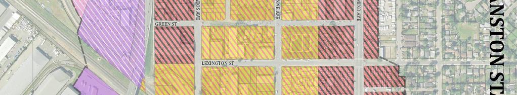
8 HARV ARD S T Attachment 2 RIO LIND A BL DEL PASO BL EL CAMINO AV AUBURN AUBURN BL City of Sacramento, Development Services Department Geographic Information System ARDEN WY Legend }þ!"#$ 5!"#$ 80!"#$ 5 Sw an stonareab oundar y )*+,- 80!"#$ 5 Feet!"#$ 80!"#$ ,000 2,000 }þ )*+, M (/ 50 Aerial Map }þ 99 Swanston Station Transit Village Specific Plan F. Harris 10/28/09 }þ 8 of 738
9 Attachment 3 SPECIFIC PLAN BACKGROUND The Swanston Station Transit Village Specific Plan envisions a strategic approach to development that involves a set of priority improvements and matching these priorities to funding mechanisms. Phase 1, the Strategic Plan, focuses on improvements and development or redevelopment west of the railroad tracks in an area currently undergoing transition. Phase 1 calls for new infill development adding approximately 300 dwelling units and approximately 140,000 gross square feet of commercial floor space along Arden Way and the parcels closest to the light rails station bounded by Dixieanne Avenue and Lexington Street to capitalize on the energy of recent developments and the revitalization of Dixieanne Park. Phase 2, the Long-Term Plan, anticipates the development of approximately 2,600 additional dwelling units and 510,000 gross square feet of additional commercial floor space after the year The Swanston Station Transit Village Plan provides clear direction on the development of the public and private interface. Below is a discussion of the Specific Plan s planning strategies and key elements. Planning Strategies After extensive public workshops, five planning strategies were established from the guiding framework, which are as follows: 1. Create a Sense of Place by: a) creating a unique identity to the transit village and b) identifiable public realm 2. Improve Circulation and Connectivity by: a) improving pedestrian experience, b) providing safe and direct pedestrian crossings over the RT and SP Tracks, c) creating safe and convenient bike connections and d) completing and augmenting existing pedestrian and bicycle framework 3. Maximize TOD Potential through: a) higher density, market friendly, non autooriented development, b) utilizing vacant and underutilized opportunity sites and c) maximizing connection opportunities. 4. Build Upon Synergy of Existing Assets and Planned Development by: a) maximizing the positive investments that have or are occurring on Del Paso Boulevard, Ericson and Evergreen Streets and improvements on Dixieanne Avenue, b) capitalizing on established neighborhoods such as Woodlake, Dixieanne, South Hagginwood and Ben Ali by extending neighborhood character and creating linkages between these neighborhood and Swanston area; 5. Provide Redevelopment Incentives by: a) assembling small parcels to allow for design and construction efficiencies, b) providing essential utilities that support development, and c) providing financial incentives through the purchase and preparation of sites for private development, and d) if possible identify subsidies for development fees 9 of 738
10 These strategies assisted in establishing the vision for two distinctive neighborhoods on either side of the Union Pacific tracks that build upon the surrounding context. Key Elements In addition, the Specific Plan addresses key elements that layer to create a unique transit-oriented development. The key elements include: 1. Open Space the open space plan incorporates a hierarchy of open space amenities that support a strong and vibrant community life, providing gathering opportunities, amenities for a variety of users, relief from the intensity of development, and improved access to the transit station and other major destinations. This is accomplished through: a. 10 acres of park space developed as four neighborhood parks, two on either side or the light rail lines. Dixieanne Park is envisioned as the central neighborhood park west of the tracks. b. Pocket parks small open space amenities approximately 0.4± acres of open space may include seating areas, gathering areas, multi-use play areas, children s play areas, tot lots, gardens and picnic areas. The plan identifies eight pocket parks integrated throughout the plan area for a total of 3.2± acres. c. Plazas and Promenades meant to strengthen the bicycle and pedestrian connections to the light rail station. This open space area comprised of three plazas and promenades totaling 1.25± acres bracket the station area and utilize textured paving materials, shade shelters, and trees to enhance the transit experience. d. Mews and Greenways are incorporated to break up large blocks, provide buffer space between existing and new development. In addition, mew and greenways create opportunities for on-site storm water filtration. These greenways total more than five acres and are woven throughout the plan area. 2. Transportation- The transportation infrastructure comprises a variety of transit options from automobile, public transit, pedestrian, and bicycle. The street network provides opportunities for all transportation components. The circulation network for the Swanston Station transit village includes a hierarchy of streets, which provide increased identity and connectivity for the area. a. Arterials within the Swanston Station area include Arden Way and El Camino Avenue. These two streets serve as major vehicular corridors in North Sacramento. In order to support alternative modes of transportation to the transit station and local amenities, improvements to the pedestrian and bicycle environment are warranted. b. Collector Streets, identified as Entry Streets, provide access to the transit village and station and are key to the design because of the poor visibility of the 10 of 738
11 transit station and its location off major roadways. Harvard Street east of the tracks and Evergreen Street west of the tracks are identified as entry streets c. Neighborhood Streets access within the area is provided by a grid pattern that supports the highly connected public realm. d. Alleys provide rear access to residential and mixed use developments, parking and service areas. Alleys are a key component of the layout locating autooriented functions behind development, allowing a pedestrian friendly edge to line the sidewalks along the streets. e. Transit circulation supports the light rail station. Planned relocation of the Arden/Del Paso bus transfer center establishes the Swanston Station as a major transit hub. The transit promenade directly links the light rail station with the bus center to streamline multi-modal transit connections, encouraging alternate means of accessing the Swanston Station. The Point West Shuttle service is planned to be extended to connect the subareas of east and west of the tracks to major destinations in the Point West neighborhood such as Arden Fair Mall and a variety of hotels. f. Bicycle and Pedestrian circulation is to be improved and expanded to support connectivity and access to and around the light rail station, primary routes that children use to access Woodlake and Northwood elementary schools and local amenities. A new pedestrian and bicycle bridge connecting Dixieanne Avenue and Silica Avenue will provide a direct connection between the transit station and destinations east of the tracks. A pedestrian off-ramp from the west side of Arden Way overpass is intended to shorten the travel route for those crossing the tracks to access the buses and light rail directly connecting the bus transfer center to the transit promenade. Street sections for local streets will follow the Pedestrian Friendly Street Standards. Due to constrained rights-of-way, street redesigns need to balance the needs of automobiles, bicyclists and pedestrians. 3. Land Use, Zoning and Design Guidelines the vision for Swanston Station is a mixed use community with two distinct characters on either side of the tracks. The west side is a residential mixed use community characterized by Dixieanne Avenue, the residential Main Street and focal points such as Dixieanne Park and the transit station and plaza, that serve as community gathering spaces. Development west of the tracks is interspersed with a variety of greenways, mews and pocket parks which provide open space relief and amenities for residents. The east side of the tracks is more employment oriented supporting a wide range of uses including residential. Development is organized around Silica Avenue with a series of activity nodes along Harvard Street. While much of the development is more suburban in nature, the orientation of buildings and careful design of the public realm encourages pedestrian and bicycle use. 11 of 738
12 The Specific Plan provides design guidelines for implementing the vision, by integrating new circulation patterns and open space network into the residential and mixed use development planned. The two sub-areas on either side of the track have different characteristics based upon the existing context of the surrounding development. The west side of the tracks is planned as predominantly residential with a fine-grained development pattern, respecting the small scale character of the existing Dixieanne neighborhood. The concept on the west side is characterized by smaller one to three story single-family townhomes and row houses on the westernmost edge of the Specific Plan, complementing the existing single family homes. Density will be achieved with small lot development. The scale and intensity rises as residential uses transition into three-story attached townhomes and row houses and four to five story condominiums and apartments closest to the transit station. East of the tracks the plan envisions high intensity and large-scale office, mixed use and residential buildings that complement the existing business parks in scale. The Specific Plan calls for a mixed use land use designation with a significant amount of housing. The market study completed for the plan determined that residential uses were more likely east of the tracks, but the existing diversity of uses in the area led to the determination to provide greater flexibility for future development. The Specific Plan recognizes higher intensity development north of Silica Avenue and west of Harvard Street. North of Silica Avenue and east of Harvard Street, two to four story townhomes are envisioned to transition to the existing Ben Ali neighborhood. Silica Avenue serves as the main street for the eastern portion of the plan area and is envisioned to be lined with mixed use and residential developments to provide an active edge to the street. The design guidelines in the Swanston Station Specific Plan provide a tool for guiding the development of both the public realm and private realm around the Swanston light rail station. The public realm guidelines provide general direction for roadways, sidewalks and landscaping, crosswalks and bulbouts, cross-track connections, publicprivate interface, street furniture and lighting, and signage, with more specific guidelines for Dixieanne Avenue, Arden Way, El Camino Avenue, Evergreen Street, Silica Avenue, neighborhood parks, pocket parks, the transit plaza and promenades, greenways, and mews. The private realm guidelines provide general guidance for block scale, building scale, residential density and floor area ratio, massing, heights and setbacks, building character and façade articulation, parking, alleys and service access, building uses, stormwater management, and passive cooling with more specific guidance related to building prototypes. 4. Infrastructure Water and sewer infrastructure in the area is adequate to serve the current uses and some immediate growth. The area s drainage infrastructure presents some existing deficiencies. Furthermore, the area s drainage system does not currently meet the City s drainage performance standard as some streets may flood in a 10-year storm and certain properties may be damaged in a 100-year storm. The proposed development scenarios pose a potentially significant impact on the City s drainage system. The City currently does not have a drainage capital improvement program which can implement the needed improvements to solve the 12 of 738
13 existing deficiencies and accommodate future growth. However, the DOU plans to propose a Development Impact Fee and a Drainage Rate augmentation which would result in an adequate capital improvement program. In the interim, or should those efforts not materialize, each project shall mitigate its drainage impacts by doing no harm. In 1996 West Yost & Associates prepared a Drainage Master Plan for Basin 151 (WYA report) that identified improvements needed to upgrade the system to meet the City s 10 and 100 year drainage performance criteria. The WYA report identified two above ground storm water detention basins within the plan area: 1) the Green Street Basin located near Green and Calvados Avenue; and 2) the Intertrack Basin, located near the railroad tracks. The proposed Swanston Transit Village Specific Plan would not interfere with construction of the Intertrack Basin. Since the Green Street Basin is no longer available it was not included in the Long Term Development scenario. The Plan proposes two storm water detention basins equal in function to the previously proposed Green Street basin through the construction of above ground detention basins in the short term to be replaced by a subsurface detention system in the long term. With the construction of a subsurface detention system, the plan is to be able to maximize development opportunities adjacent to the light rail station. While this may be a costly approach, funding may be available through redevelopment tax increment as well as grants for infrastructure improvements for infill development as the plan area builds out. 5. Implementation: Phasing and Financing Phasing and financing of the Specific Plan area must be accomplished carefully to provide incentive for catalytic projects to emerge without mandating an unrealistic amount of immediate change. Anticipated phasing of development was noted above; Phase 1 Strategic Plan and Phase 2 Long Term Plan. The plan has identified several short and long term actions that include focusing investment, investing in the public realm and implementing improvements such as the pedestrian, bike overpass across the light rail tracks and exploring the possibility of expanding the North Sacramento Redevelopment Area to the east of the tracks to maximize funding opportunities to address both of these phases. 13 of 738
14 Attachment 4 LAND USE BACKGROUND The Swanston Station Transit Village Specific Plan takes full advantage of the close proximity of the Swanston Light Rail Station. The area currently is a mix of land uses ranging from single family homes to industrial. These uses are predominately of low intensity and may once have benefited from proximity to heavy rail but do not take advantage, nor enhance the role of the light rail station that exists today. The Sacramento 2030 General Plan designates land in the Swanston Station Transit Village area as Urban Neighborhood Low Density (27.5± ga); Employment Center (Mid Rise) (60.2± ga); Urban Center Low (40.7± ga); and Urban Corridor Low (61.7± ga). Urban Neighborhood Low Density designated areas provide for moderate-intensity urban housing and neighborhood-support uses including the following: small-lot singlefamily dwellings, small-lot single-family attached dwellings (e.g., duplexes, triplexes, townhomes), accessory second units, mixed-use neighborhood-serving commercial, and compatible public, quasi-public, and special uses. Residential densities fall between 12 and 36 dwelling units per net acre. Floor area ratios fall between a range of 0.5 and 1.5. Employment Center (Mid Rise) designated areas play a critical role in accommodating new businesses and creating new jobs. The combination of high-density buildings and low site coverage in existing employment centers provides the opportunity for new infill development in these areas with complementary uses that transforms the existing single use areas into more self-sufficient mixed-use areas with reduced dependence on automobile transportation. Residential densities fall between 18 and 60 dwelling units per net acre. Floor area ratios fall between 0.35 and 2.0. Urban Center Low designated areas provide for smaller urban areas throughout the city. Each center includes employment-intensive uses, a mix of housing, and a wide variety of retail uses. Urban Center Low is located around light rail stations, along local arterials, and in other key areas of the city. Building heights for Urban Center Low tend toward low- and mid-rise structures. Other characteristics will take into account adjacent neighborhoods, such as stepping down building heights from mid-rise structures to adjacent lower density neighborhoods. Residential densities fall between 20 and 150 dwelling units per net acre. Floor area ratios fall between 0.4 and 4.0. Urban Corridor Low designated areas include street corridors that have multistory structures and more-intense uses at major intersections, lower-intensity uses adjacent to neighborhoods, and access to transit service throughout. At major intersections, nodes of intense mixed-use development are bordered by lower-intensity single-use residential, retail, service, and office uses. Street-level frontage of mixed-use projects is developed with pedestrian-oriented uses. The streetscape is appointed with landscaping, lighting, public art, and other pedestrian amenities. Residential densities 14 of 738
15 fall between 20 and 110 dwelling units per net acre. Floor area ratios fall between 0.3 and 3.0. The assignment of land use designations for the properties within the Specific Plan was driven by the principles established for the Specific Plan. The Specific Plan land use designations of Mixed Use and Residential Mixed Use are consistent with the General Plan land use designations for each of the properties, and the density and intensity of those uses established by the Specific Plan are also consistent with the General Plan development standards applicable to each of the properties. The North Sacramento Community Plan and the Arden Arcade Community Plan both include portions of the Swanston Station Transit Village Specific Plan area. Amendments to these community plan chapters of the 2030 General Plan will be brought forward by staff at a later date to develop a clearer integration of the Specific Plan guidelines. 15 of 738
16 Attachment 5 ZONING BACKGROUND The Specific Plan area is currently a combination of zoning designations dominated by Industrial (M-1) zoning. The Specific Plan recommends rezoning approximately 77± gross acres of the property in the Specific Plan area to Residential Mixed Use Transit Overlay (RMX-TO) and approximately 58± gross acres to General Commercial Transit Overlay (C-2-TO) allowing flexibility in the development of the area and greater residential density consistent with transit-oriented development (Exhibit A). This zoning takes advantage of the existing Swanston light rail station to promote transit supportive uses, discourage auto-related uses, and allow greater height, density and intensity close to transit. In the Specific Plan area, the Residential Mixed Use Transit Overlay (RMX-TO) zone would permit higher density residential, office and limited commercial uses. Commercial development would be limited to a maximum of fifty (50%) percent of the gross floor area of the development and could be developed in the same building or in a separate building on the same site as the residential development. Residential density in this zone ranges from a minimum of 15 to a maximum of 60 dwelling units per net acre. Densities greater than 60 units per net acre may be allowed by approval of a Planning Commission special permit if the higher density is consistent with the General Plan. The maximum height allowed is 55 feet but can be increased to 75 feet with Planning Director approval, except for parcels located within 100 feet of property zoned or used for single family use. Finally, nonresidential development in this zone has a net floor area ratio (FAR) of not less than 0.4 and not greater than 3.0. In the Specific Plan area, the General Commercial Transit Overlay Zone (C-2-TO) would provide for the sale of commodities, or performance of services, including repair facilities, small wholesale stores or distributors, limited processing and packaging, and residential. In this zone the maximum height allowed is 55 feet but can be increased to 75 feet with Planning Director approval, except for parcels located within 100 feet of property zoned or used for single family use. Finally, nonresidential development in this zone has a net floor area ratio (FAR) of not less than 0.4 and not greater than 3.0. On the east side of the tracks, several parcels currently zoned for industrial uses (M-1, M-1-LI, M-2) south of Arden Way and several parcels zoned for office uses (OB-PUD, OB-LI) on and adjacent to the former USAA properties were not proposed for rezoning as part of the Specific Plan. Subsequent to the completion of the draft Specific Plan, the decision was made to recommend that the USAA properties be rezoned to Commercial (C-2) to bring the properties into consistency with the 2030 General Plan designations that had been applied in March of Recognizing the current economic downturn and the absence of a convenient pedestrian crossing of the tracks, rezoning of all of the properties in the Specific Plan seemed presumptuous and premature. For these reasons, staff proposes to 16 of 738
17 strategically rezone properties in the Specific Plan area in incremental phases both spatially and in intensity. The initial phase calls for: rezoning of parcels along the station side of the tracks at Swanston Station and south of the realigned Lumberjack curve to Residential Mixed Use Transit Overlay (RMX-TO); rezoning of blocks north and south of Dixieanne Avenue and blocks north of Calvados Avenue to Residential Mixed Use (RMX); rezoning of the blocks south of Arden Way to General Commercial Transit Overlay (C-2- TO); rezoning of the block along the north side of Arden Way, the blocks along the south side of El Camino, the USAA properties, three parcels along Knoll Street, and one parcel on Harvard Street to General-Commercial (C-2); and rezoning all of the Light Industrial (M-1) on the east side of the tracks to Light Industrial Review (M-1-R). See Exhibit B. The Light Industrial Review (M-1-R) zone allows most fabricating activities, with the exception of heavy manufacturing and the processing of raw materials after a plan review has been approved by the Planning Commission or Zoning Administrator to ensure that future development will relate to characteristics of the site prior to any building permit or other construction permit. This zone was selected as an interim rezoning designation for several parcels in the Specific Plan area that were planned for Residential Mixed Use Transit Overlay to recognize that transformation, especially on the east side of the tracks, will happen gradually and will rely heavily on a new pedestrian crossing of the tracks that has yet to be approved or funded. The addition of the -R designation (Plan Review) will allow the City to better monitor the area to ensure that future development does not deviate significantly from the vision established by the 2030 General Plan and the Specific Plan. In the Specific Plan area, the Residential Mixed Use (RMX) zone allows a mix of moderate density residential and neighborhood-serving commercial uses as a matter of right, and is intended to preserve existing housing stock and the residential character of neighborhoods while encouraging the development of new housing opportunities, as well as neighborhood-oriented ground-floor retail and service uses. Commercial and office uses are limited to the ground floor only and may occupy up to a maximum of fifty (50) percent of the building square footage. Up to 100% commercial and office uses may be permitted with a special permit. Residential density cannot exceed 36 dwelling units per net acre. Building heights shall not exceed thirty-five (35) feet; however, the planning commission shall have the authority to issue a special permit for a residential or residential mixed-use building up to forty-five (45) feet in height. This zone has no minimum floor area ratio for nonresidential development. This zone was selected as an interim rezoning designation for several parcels identified for Residential Mixed Use Transit Overlay (RMX-TO) in the Specific Plan in order to remove the minimum floor area ratio for parcels anticipated to realize TOD intensities after other catalyst projects closer to the station develop. In the Specific Plan area, the general commercial (C-2) zone provides for the sale of commodities, or performance of services, including repair facilities, offices, small wholesale stores or distributors, and limited processing and packaging with residential 17 of 738
18 uses allowed by special permit. Generally, the height limit for buildings in the C-2 zone located one hundred (100) feet or less from residentially zoned property is thirty-five (35) feet; forty-five (45) feet for buildings located more than one hundred (100) feet from residentially zoned property; and fifty-five (55) feet for buildings with twenty-five (25) percent or more square feet of gross floor area in residential use. There is no minimum floor area ratio for nonresidential uses. This zone was selected as an interim rezoning designation for several parcels identified for General Commercial Mixed Use Transit Overlay (RMX-TO) in the Specific Plan in order to remove the minimum floor area ratio for parcels anticipated to realize TOD intensities after other catalyst projects closer to the station develop Full implementation of the rezoning recommendations of the Specific Plan would be carried out over time as the area transforms to more transit-supportive uses and the planned pedestrian crossing is built to allow better access from the east side of the tracks to the light rail station. In this way, properties are not unreasonably required to develop at the densities and intensities expected to support a vibrant and successful transit village before that environment has had an opportunity to establish itself. The Planning Commission initiated the proposed rezonings at its meeting on January 13, of 738


19 Back to Table of Contents Exhibit A 19 of 738

20 Exhibit B 20 of 738
21 Attachment 6 DESIGN REVIEW BACKGROUND The boundaries of the Swanston Station Transit Village Specific Plan overlap with the boundaries of the existing North Sacramento Design Review District, which has an existing set of design guidelines. Rather than amending the design guidelines of the North Sacramento Design Review District to incorporate the Swanston Station design guidelines, staff believes that it would be more efficient to remove that portion of the North Sacramento Design Review District that overlaps with the Swanston Station Specific Plan area and to establish a new Swanston Station Design Review District based on the boundary and the design guidelines of the Specific Plan (Attachment 9). The design guidelines prepared as part of the Specific Plan have been reformatted to be adopted as a stand-alone document to be used for all projects within the new Swanston Station Design Review District (Attachment 11). City Council initiated the establishment of the Swanston Station Design Review District and amendments to the boundaries of the North Sacramento design Review District by resolution at its meeting on April 1, The Design Commission recommended that the City Council amend the North Sacramento Design Review District, establish the Swanston Station Design Review District, and adopt the Swanston Public and Private Realm Design Guidelines at its meeting on April 21, City staff must review the design of any proposed infill project or major renovation of or addition to an existing structure within the North Sacramento Redevelopment Area and the Swanston Design Review District. Following such a review, Staff must provide early notification to adjacent property owners and community groups of the proposed project. Once a project has been deemed consistent with the Swanston Design Guidelines by Design Review staff or the appropriate review board, as necessary, an application for a building permit may be submitted, provided that any other planning entitlements needed for the project have been approved. 21 of 738
FUTURE LAND USE ELEMENT
 FUTURE LAND USE ELEMENT GOAL I: To create and sustain a great place to live, play, and prosper Objective 1: The City of Ocala shall incorporate the principles and strategies of the Ocala 2035 Vision into
REPORT TO COUNCIL City of Sacramento
 Honorable Mayor and Members of the City Council REPORT TO COUNCIL City of Sacramento 915 I ' Street, Sacramento, CA 95814-2604 www. CityofSacramento.org Consent April 1, 2010 Title: Initiation of the Establishment
Gold Line Bus Rapid Transit Transit Oriented Development (BRTOD) Helmo Station Area Plan
 Helmo Station Area Plan") Appendix F Gold Line Bus Rapid Transit Transit Oriented Development (BRTOD) Helmo Station Area Plan Introduction and Purpose of the Plan The Gold Line Bus Rapid Transit facility is an eleven-mile dedicated
Appendix F Gold Line Bus Rapid Transit Transit Oriented Development (BRTOD) Helmo Station Area Plan Introduction and Purpose of the Plan The Gold Line Bus Rapid Transit facility is an eleven-mile dedicated
REQUEST Current Zoning: O-15(CD) (office) Proposed Zoning: TOD-M(CD) (transit oriented development mixed-use, conditional)
 (office) Proposed Zoning: TOD-M(CD) (transit oriented development mixed-use, conditional)") Rezoning Petition 2016-117 Zoning Committee Recommendation January 4, 2017 REQUEST Current Zoning: O-15(CD) (office) Proposed Zoning: TOD-M(CD) (transit oriented development mixed-use, conditional) LOCATION
Rezoning Petition 2016-117 Zoning Committee Recommendation January 4, 2017 REQUEST Current Zoning: O-15(CD) (office) Proposed Zoning: TOD-M(CD) (transit oriented development mixed-use, conditional) LOCATION
A. WHAT IS A GENERAL PLAN?
 I. Introduction A. WHAT IS A GENERAL PLAN? A general plan is the planning guideline for the future of a city. It contains goals and policies which regulate urban development, the protection of the natural
CITY OF PUYALLUP. Background. Development Services
 CITY OF PUYALLUP Development Services 333 South Meridian Puyallup WA 98371 To: City Council From: Katie Baker, AICP, Planning Division Re: South Hill Neighborhood Plan Adoption Date: (Meeting date: February
c h a p t e r one Introduction
 c h a p t e r one Introduction Cities are fantastically dynamic places, and this is strikingly true of their successful parts, which offer a fertile ground of the plans of thousands of peoples. Jane Jacobs
Town Center (part of the Comprehensive Plan)
") Town Center (part of the Comprehensive Plan) Mercer Island Town Center Looking North (2014) In 1994, a year-long process culminated in a set of design guidelines and code requirements for the Town Center
Town Center (part of the Comprehensive Plan) Mercer Island Town Center Looking North (2014) In 1994, a year-long process culminated in a set of design guidelines and code requirements for the Town Center
Land Use Amendment in Southwood (Ward 11) at and Elbow Drive SW, LOC
 at and Elbow Drive SW, LOC") 2018 November 15 Page 1 of 10 EXECUTIVE SUMMARY This land use amendment application was submitted by Rick Balbi Architect on 2017 August 31 on behalf of Sable Developments Ltd, and with authorization from
2018 November 15 Page 1 of 10 EXECUTIVE SUMMARY This land use amendment application was submitted by Rick Balbi Architect on 2017 August 31 on behalf of Sable Developments Ltd, and with authorization from
REPORT TO PLANNING COMMISSION City of Sacramento
 REPORT TO PLANNING COMMISSION City of Sacramento 915 I Street, Sacramento, CA 951-271 STAFF REPORT January 13, 211 Honorable Members of the Planning Commission: Subject: Northeast Line Implementation Plan
AWH REPORT OF THE PLANNING AND DEVELOPMENT DEPARTMENT FOR APPLICATION FOR REZONING ORDINANCE TO PLANNED UNIT DEVELOPMENT
 AWH REPORT OF THE PLANNING AND DEVELOPMENT DEPARTMENT FOR APPLICATION FOR REZONING ORDINANCE TO PLANNED UNIT DEVELOPMENT MAY 8, 2014 The Planning and Development Department hereby forwards to the Planning
The transportation system in a community is an
 7 TRANSPORTATION The transportation system in a community is an important factor contributing to the quality of life of the residents. Without a sound transportation system to bring both goods and patrons
ELMVALE ACRES SHOPPING CENTRE MASTER PLAN
 ELMVALE ACRES SHOPPING CENTRE MASTER PLAN Contents 1.0 INTRODUCTION... 2 2.0 LOCATION... 2 3.0 EXISTING CONTEXT... 2 4.0 VISION & GUIDING PRINCIPLES... 2 5.0 LAND USE AND BUILT FORM... 4 5.1 St. Laurent
Planning Commission Staff Report June 5, 2008
 Owner/Applicant Taylor Village Sacramento Investments Partners, LP c/o Kim Whitney 1792 Tribute Road #270 Sacramento, CA 95815 Staff Recommendation Planning Commission Staff Report Project: File: Request:
EXISTING COMPREHENSIVE PLAN
 EXISTING COMPREHENSIVE PLAN Town Center Land Use Element: V. LAND USE POLICIES Town Center Mercer Island's business district vision as described in "Your Mercer Island Citizen-Designed Downtown" was an
City of Sacramento City Council 915 I Street, Sacramento, CA,
 City of Sacramento City Council 915 I Street, Sacramento, CA, 95814 www.cityofsacramento.org 7 Meeting Date: 3/22/2011 Report Type: Consent Title: Contract: Power Inn Streetscape Project (T15078000) Report
Midtown Greenway Land Use and Development Plan Executive Summary
 Midtown Greenway Land Use and Development Plan Executive Summary Introduction The Midtown Greenway Land Use and Development Plan sets policy direction for land use and development in the Midtown Greenway
Welcome. Walk Around. Talk to Us. Write Down Your Comments
 Welcome This is an information meeting introducing the applications for proposed redevelopment of the Yorkdale Shopping Centre site at 3401 Dufferin Street and 1 Yorkdale Road over the next 20+ years,
Chapter 1.0 Introduction
 Chapter 1.0 Introduction 1.1 Background The North Metro commuter rail line is part of the RTD FasTracks regional transit system expansion program to build more than 100 miles of rail transit throughout
EXHIBIT A. Tax Increment Reinvestment Zone No. 1 (Town Center) First Amended Project Plan 1
 First Amended Project Plan 1") EXHIBIT A Tax Increment Reinvestment Zone No. 1 (Town Center) First Amended Project Plan 1 1 As amended by Resolution No. 2008-02-001(TR1R) of the Tax Increment Reinvestment Zone No.1, and approved to
EXHIBIT A Tax Increment Reinvestment Zone No. 1 (Town Center) First Amended Project Plan 1 1 As amended by Resolution No. 2008-02-001(TR1R) of the Tax Increment Reinvestment Zone No.1, and approved to
Cobb County Design Guidelines Mableton Parkway & Veterans Memorial Highway Community Design Workshop January 12, 2017
 Community Design Workshop January 12, 2017 Agenda Opening Remarks / Introductions Scope of Work Existing Conditions Key Issues / Opportunities VPS Summary Draft Vision & Goal Statement Implementation Concepts
Executive Summary. NY 7 / NY 2 Corridor
 Executive Summary NY 7 / NY 2 Corridor Transportation and Land Use Study December 2005 Prepared for: Town of Colonie Capital District Transportation Committee Prepared by: Introduction: Land use decisions
Staff Report to the North Ogden City Planning Commission
 Staff Report to the North Ogden City Planning Commission SYNOPSIS / APPLICATION INFORMATION Application Request: Concept review on a legislative application to rezone land located at approximately 1750
CHAPTER 3 VISION, GOALS, & PLANNING PRINCIPLES. City of Greensburg Comprehensive Plan. Introduction. Vision Statement. Growth Management Goals.
 CHAPTER 3 VISION, GOALS, & PLANNING PRINCIPLES Introduction The Greensburg Comprehensive Plan is intended as a working community document. A combination of long and short-term goals, this document is intended
TRANSPORTATION ELEMENT GOALS, OBJECTIVES, AND POLICIES
 TRANSPORTATION ELEMENT GOALS, OBJECTIVES, AND POLICIES GOAL 2 The City shall provide a safe, convenient, effective, and energy efficient multimodal transportation system which is coordinated with the Future
Policies and Code Intent Sections Related to Town Center
 Policies and Code Intent Sections Related to Town Center The Town Center Vision is scattered throughout the Comprehensive Plan, development code and the 1994 Town Center Plan. What follows are sections
Making TOD Work in the Heart of Suburban Sprawl
 Making TOD Work in the Heart of Suburban Sprawl Rocky Mountain Land Use Institute March 6, 2009 Speakers Ben Herman, FAICP, Principal Clarion Associates Darcie White, AICP, Principal Clarion Associates
CHAPTER 7: Transportation, Mobility and Circulation
 AGLE AREA COMMUNITY Plan CHAPTER 7 CHAPTER 7: Transportation, Mobility and Circulation Transportation, Mobility and Circulation The purpose of the Transportation, Mobility and Circulation Chapter is to
Urban Design Manual PLANNING AROUND RAPID TRANSIT STATIONS (PARTS) Introduction. Station Study Areas
 Introduction. Station Study Areas") 111111 PLANNING AROUND RAPID TRANSIT STATIONS (PARTS) Introduction The ION rapid transit system will link Waterloo, Kitchener and Cambridge through a central transit corridor (CTC). There are a number
111111 PLANNING AROUND RAPID TRANSIT STATIONS (PARTS) Introduction The ION rapid transit system will link Waterloo, Kitchener and Cambridge through a central transit corridor (CTC). There are a number
Staff Report and Recommendation
 Community Planning and Development Planning Services 201 W. Colfax Ave., Dept. 205 Denver, CO 80202 p: 720.865.2915 f: 720.865.3052 www.denvergov.org/cpd TO: City Council Neighborhoods and Planning Committee
Silverdale Regional Center
 Silverdale Regional Center Vision for Silverdale Regional Center The Silverdale Regional Center Plan (Plan) will guide the evolution of the Silverdale Regional Center from a collection of strip malls and
Pedestrian and Bike Bridge LOGO
 6.2.2 Pedestrian and Bike Bridge The proposed pedestrian and bike crossing re-envisions the existing bridge at Pismo Creek on Cypress Street. The bridge is currently underutilized by vehicular through
C. Westerly Creek Village & The Montview Corridor
 C. Westerly Creek Village & The VISION Community Vision When the goals of the city are achieved Westerly Creek Village, a distinctive community defined by Montview Boulevard and Westerly Creek, is a strong
Department of Community Development. Planning and Environmental Review Division Revised Notice of Preparation
 Department of Community Development Michael J. Penrose, Acting Director Divisions Building Permits & Inspection Code Enforcement County Engineering Economic Development & Marketing Planning & Environmental
North Fair Oaks Community Plan Summary and Information
 North Fair Oaks Community Plan Summary and Information WHAT IS THE NORTH FAIR OAKS COMMUNITY PLAN? The North Fair Oaks Community Plan is part of the San Mateo County General Plan, and establishes policies
SPECIFIC PLAN Requirements
 CITY OF LANCASTER PLANNING DEPARTMENT 44933 Fern Avenue, Lancaster, California 93534 (661) 723-6100 SPECIFIC PLAN Requirements Purpose The purpose of a specific plan is to provide for the logical development
MEMORANDUM. DATE: March 15, Chairman and Members Community Redevelopment Agency. Leif J. Ahnell, C.P.A., C.G.F.O. Executive Director
 MEMORANDUM DATE: March 15, 2019 TO: FROM: Chairman and Members Community Redevelopment Agency Leif J. Ahnell, C.P.A., C.G.F.O. Executive Director SUBJECT: Camino Square, IDA No. CRP-16-02, located at 171
DENVER DESIGN DISTRICT GDP
 DENVER DESIGN DISTRICT GDP Urban Design Standards and Guidelines November 17, 2008 Amended February 3, 2016 City and County of Denver CF Property Management, Inc. C/O Denver Design District - Starboard
REZONING GUIDE. Zone Map Amendment (Rezoning) - Application. Rezoning Application Page 1 of 3. Return completed form to
 - Application. Rezoning Application Page 1 of 3. Return completed form to") Zone Map Amendment (Rezoning) - Application COMMUNITY PLANNING & DEVELOPMENT REZONING GUIDE Rezoning Application Page 1 of 3 PROPERTY OWNER INFORMATION* CHECK IF POINT OF CONTACT FOR APPLICATION Property
Zone Map Amendment (Rezoning) - Application COMMUNITY PLANNING & DEVELOPMENT REZONING GUIDE Rezoning Application Page 1 of 3 PROPERTY OWNER INFORMATION* CHECK IF POINT OF CONTACT FOR APPLICATION Property
Proposed Comprehensive Plan Strategies DRAFT for discussion June 28, 2017
 Proposed Comprehensive Plan Strategies DRAFT for discussion June 28, 2017 Land Use Rural Areas Refine the Farm and Forest area (FF) Update FF boundaries to account for existing lots less than five acres
REQUEST FOR QUALIFICATIONS
 REQUEST FOR QUALIFICATIONS VILLAGE OF HAMBURG COMPREHENSIVE ZONING/LAND USE REGULATIONS UPDATE Prepared By: Village of Hamburg 100 Main Street Hamburg, New York 14075 Village of Hamburg RFQ Page 1 of 10
City of Tacoma Planning and Development Services
 Agenda Item E-1 City of Tacoma Planning and Development Services To: Planning Commission From: Elliott Barnett, Planning Services Division Subject: Tacoma Mall Regional Center Subarea Plan and EIS Meeting
Lehigh Acres Land Development Regulations Community Planning Project
 Lehigh Acres Land Development Regulations Planning Effort Summary In July, 2010 Commissioner Frank Mann invited the Lehigh Acres community to start discussing how to achieve their recently adopted community
TREASURE COAST REGIONAL PLANNING COUNCIL M E M O R A N D U M. To: Council Members AGENDA ITEM 5H
 TREASURE COAST REGIONAL PLANNING COUNCIL M E M O R A N D U M To: Council Members AGENDA ITEM 5H From: Date: Subject: Staff October 17, 2008 Council Meeting Local Government Comprehensive Plan Review Draft
Atlanta BeltLine Subarea 3 Master Plan Update
 Atlanta BeltLine Subarea 3 Master Plan Update April 14, 2018 Workshop Meeting 1 22 miles, connecting 45 neighborhoods 22 MILES of transit 46 MILES of streetscapes and complete streets 33 MILES of urban
Establish a network of streetscaped vehicle and pedestrian routes that connect within and outside the Plan area.
 This Plan s urban design goals are to create an urban scale, walkable community with connections to transit, parks, and services and with amenities and facilities for residents and employees. The 1992
Northwest Rail Corridor and US 36 BRT Development Oriented Transit Analysis 4.4 STATION AREA FINDINGS
 4.4 STATION AREA FINDINGS Each station is different, and each one requires a separate set of recommendations based on the vision for the site. This section outlines an initial TOD strategy and recommendations
Westwind Developments Ltd. PIONEER LANDS AREA STRUCTURE PLAN - PROPOSED AMENDMENT
 FEBRUARY 2013 TABLE OF CONTENTS 1.0 BACKGROUND... 1 1.1 Amendment... 1 2.0 LOCATION & CONTEXT... 2 2.1 Land Ownership... 2 3.0 POLICY CONTEXT... 3 3.1 Municipal Development Plan... 3 3.2 Capital Region
URBAN DESIGN BRIEF URBAN DESIGN BRIEF 721 FRANKLIN BLVD, CAMBRIDGE August 2018
 URBAN DESIGN BRIEF URBAN DESIGN BRIEF 721 FRANKLIN BLVD, CAMBRIDGE August 2018 DESIGN BRIEF CONTENTS PART A 1.0 INTRODUCTION 2.0 DESCRIPTION & ANALYSIS OF SITE CONTEXT 3.0 DESIGN CONSTRAINTS AND OPPORTUNITIES
ARTICLE 6: Special and Planned Development Districts
 ARTICLE 6: Special and Planned Development Districts 6-10 Traditional Neighborhood Development (TND) District 6-10.10 Purpose and Intent The Traditional Neighborhood Development (TND) District provides
1.0 VISION STATEMENT. December 6, PRINCIPLES
 Vision Statement Lincoln Regional Airport 1.0 VISION STATEMENT 1.1 City LOCATION of AND OVERVIEW The Easton Lincoln Place Land Use Master Plan identifies the principles, goals, policies, and standards
City of Bristol Route 6 Corridor Implementation Program
 City of Bristol Route 6 Corridor Implementation Program FITZGERALD & HALLIDAY, INC. Innovative Planning, Better Communities June 2017 Route 6 Corridor Plan IMPLEMENTATION PROGRAM The following Implementation
REPORT TO PLANNING COMMISSION City of Sacramento
 REPORT TO PLANNING COMMISSION City of Sacramento 915 I Street, Sacramento, CA 95814-2671 3 PUBLIC HEARING September 23, 2010 Members of the Planning Commission Subject: Florin Road Corridor Plan - Policies
SOUTH NATOMAS COMMUNITY PLAN
 SOUTH NATOMAS Community Plan Part Three : COMMUNITY PLAN AREAS AND SPECIAL STUDY AREAS SACRAMENTO 2030 GENERAL PLAN Contents Community Location... 3-SN-3 Community Vision... 3-SN-4 Community Profile...
Subregion 4 Central Avenue-Metro Blue Line Corridor Transit-Oriented Development (TOD) Implementation Project. Community Meeting April 27, 2011
 Implementation Project. Community Meeting April 27, 2011") Subregion 4 Central Avenue-Metro Blue Line Corridor Transit-Oriented Development (TOD) Implementation Project Community Meeting April 27, 2011 Overview Introduction to Subregion 4 TOD Implementation Program
Subregion 4 Central Avenue-Metro Blue Line Corridor Transit-Oriented Development (TOD) Implementation Project Community Meeting April 27, 2011 Overview Introduction to Subregion 4 TOD Implementation Program
ARLINGTON COUNTY, VIRGINIA
 ARLINGTON COUNTY, VIRGINIA County Board Agenda Item Meeting October 15, 2005 DATE: September 28, 2005 SUBJECT: Request to Advertise the adoption of the 2005 Clarendon Sector Plan C. M. RECOMMENDATION:
Highland Village Green Design Guidelines
 Highland Village Green Design Guidelines Publishing Information Title Highland Village Green Design Guidelins Author The City of Calgary Status DRAFT - Proposed document subject to changes Additional Copies
Secrest Short Cut and Monroe Expressway Small Area Plan AUGUST 29, 2018
 Secrest Short Cut and Monroe Expressway Small Area Plan AUGUST 29, 2018 Background and Process Monroe Expressway will be open by the end of 2018 Union County and Indian Trail identified a need to revisit
9 th Street Sub Area Plan
 9 th Street Sub Area Plan In the 1990 s, when the Township prepared the last Master Plan, the 9 th Street corridor was studied as part of a larger 9 th Street Focus Area that included the West Main Street
Review of Opportunity Area C Draft Comprehensive Plan and Draft BOS Follow-On Motions. Special Working Group Meeting March 4, 2015
 Review of Opportunity Area C Draft Comprehensive Plan and Draft BOS Follow-On Motions Special Working Group Meeting March 4, 2015 The slides that follow identify where the draft Comprehensive Plan has
Windsor Locks Transit-Oriented Development Planning Grant Request. Project Background
 Windsor Locks Transit-Oriented Development Planning Grant Request Project Background Downtown Windsor Locks runs along Main Street in the vicinity of the intersection of Routes 159 and 140. The current
City Center Specific Plan Amendments And Background Report City of Richmond. PLANNING COMMISION FINAL DRAFT January, 2001
 City Center Specific Plan Amendments And Background Report City of Richmond PLANNING COMMISION FINAL DRAFT January, 2001 TABLE OF CONTENTS Page LIST OF TABLES... LIST OF FIGURES... INDEX... OVERVIEW...
LAND USE AMENDMENT DOWNTOWN COMMERCIAL CORE (WARD 7) MACLEOD TRAIL SE AND 5 AVENUE SE BYLAW 254D2017
 MACLEOD TRAIL SE AND 5 AVENUE SE BYLAW 254D2017") Page 1 of 10 EXECUTIVE SUMMARY This Land Use Amendment application seeks to redesignate a full downtown block (currently the YWCA site) from a Direct Control based on the CM-2 District (Land Use Bylaw
Page 1 of 10 EXECUTIVE SUMMARY This Land Use Amendment application seeks to redesignate a full downtown block (currently the YWCA site) from a Direct Control based on the CM-2 District (Land Use Bylaw
TRANSIT-ORIENTED DEVELOPMENT POLICY DRAFT. City Planning and Development Department Kansas City, Missouri
 TRANSIT-ORIENTED DEVELOPMENT POLICY DRAFT City Planning and Development Department Kansas City, Missouri What is Transit Oriented Development (TOD)? Development that focuses land uses around a transit
Hockessin Community Redevelopment Plan
 Hockessin Community Redevelopment Plan 3.1 Introduction The Community Redevelopment Plan for the Village of Hockessin is the result of the people s vision for a distinct village center that serves as the
REPORT OF THE PLANNING AND DEVELOPMENT DEPARTMENT FOR APPLICATION FOR REZONING ORDINANCE TO PLANNED UNIT DEVELOPMENT AUGUST 18, 2016
 REPORT OF THE PLANNING AND DEVELOPMENT DEPARTMENT FOR APPLICATION FOR REZONING ORDINANCE TO PLANNED UNIT DEVELOPMENT AUGUST 18, 2016 AWH The Planning and Development Department hereby forwards to the Planning
Draft Memorandum #1: Goals and Vision for Revitalization
 Keizer Revitalization Plan Draft Memorandum #1: Goals and Vision for Revitalization Submitted to: City of Keizer April 12, 2018 (revised) Prepared By: Angelo Planning Group and Otak, Inc. Project No. 17482.A
Illustration of Eastlake Farmer s Cooperative Grain Elevator. Chapter 5: implementation 5-1
 Illustration of Eastlake Farmer s Cooperative Grain Elevator Chapter 5: implementation 5-1 chapter 5: implementation Introduction The Eastlake Subarea Plan includes a wide range of recommendations intended
THAT the attached Terms of Reference for the Thornhill Centre Street Study be approved.
 COMMITTEE OF THE WHOLE AUGUST 18, 2003 THORNHILL CENTRE STREET STUDY PLANNING FILE: 15.92 Recommendation The Commissioner of Planning recommends: THAT the attached Terms of Reference for the Thornhill
Subarea 4 Indian Creek. Vision The combination of park networks and transportation amenities make Subarea 4 the greenest hub in the Corridor.
 indian creek 180 extends south from 101st Street to I-435. The I-435 and Metcalf intersection is one of the primary intersections in the Kansas City Metro Area. The area includes several residential neighborhoods
East Bench Master Plan Update
 Community & Economic Development Office of the Director East Bench Master Plan Update To: From: Planning Commission Wayne Mills, Senior Planner Date: November 18, 2015 CC: Re: Nora Shepard, City Planning
SAN RAFAEL GENERAL PLAN 2040 INTRODUCTION AND OVERVIEW
 SAN RAFAEL GENERAL PLAN 2040 INTRODUCTION AND OVERVIEW Steering Committee Presentation February 14, 2018 Purpose of General Plan Guide land use and development decisions Coordinate transportation, infrastructure,
The University District envisions, in its neighborhood
 Envisioning the University District Link Light Rail in Seattle s neighborhoods CIY OF SEALE CONCEP-LEVEL SAION AREA PLANNING RECOMMENDAION RESOLUION # 30165 EXHIBI L Vision 08.2000 he University District
3. Project Description
 3.1 PROJECT LOCATION The Platinum Triangle (herein after also referred to as the Project Area ) is located at the confluence of the Interstate 5 (I-5 Freeway) and the State Route 57 (SR-57 Freeway), in
FORMER CANADIAN FORCES BASE (CFB) ROCKCLIFFE SECONDARY PLAN. Official Plan Amendment XX to the Official Plan for the City of Ottawa
 ROCKCLIFFE SECONDARY PLAN. Official Plan Amendment XX to the Official Plan for the City of Ottawa") FORMER CANADIAN FORCES BASE (CFB) ROCKCLIFFE SECONDARY PLAN Official Plan Amendment XX to the Official Plan for the City of Ottawa 1 INDEX THE STATEMENT OF COMPONENTS PART A THE PREAMBLE PAGE Purpose...
FORMER CANADIAN FORCES BASE (CFB) ROCKCLIFFE SECONDARY PLAN Official Plan Amendment XX to the Official Plan for the City of Ottawa 1 INDEX THE STATEMENT OF COMPONENTS PART A THE PREAMBLE PAGE Purpose...
Tonight s Agenda. Summary Presentation Open House. Group Discussion Next Steps: online community wide survey
 Community Open House February 22, 2018 Tonight s Agenda Summary Presentation Open House Station 1: Project Overview and Community Input Station 2: Draft Vision and Guiding Principles Station 3: Western,
DRAFT. 10% Common Open Space
 % OF CHARLOTTE IS CATEGORIZED AS A. LAND USES : Placeholder map displaying location of Place Type GOALS: Accommodate XX% of future growth. Provide a concentration of primarily commercial and civic activity
Clairtrell Area Context Plan
 Clairtrell Area Context Plan March 2005 Urban Development Services City Planning Contents 1. Introduction... 4 2. Development Structure... 6 2.1 Streets... 7 2.1.1 Sheppard Avenue and Bayview Avenue...
TRANSIT ORIENTED DEVELOPMENT PINELLAS COUNTY MPO LIVABLE COMMUNITIES INITIATIVE PINELLAS COUNTY COMPREHENSIVE PLAN AMENDMENTS
 PINELLAS COUNTY MPO LIVABLE COMMUNITIES INITIATIVE MODEL LAND DEVELOPMENT CODE TRANSIT ORIENTED DEVELOPMENT PINELLAS COUNTY COMPREHENSIVE PLAN AMENDMENTS MPO Livable Communities Initiative Goal: Improve
Outline Plan in Belvedere (Ward 9) at Street SE, LOC (OP)
 at Street SE, LOC (OP)") 2018 October 04 Page 1 of 12 EXECUTIVE SUMMARY This outline plan application was submitted by B&A Planning Group on 2016 July 15, on behalf of Tristar Communities Inc. for 50.14 hectares (123.89 acres)
2018 October 04 Page 1 of 12 EXECUTIVE SUMMARY This outline plan application was submitted by B&A Planning Group on 2016 July 15, on behalf of Tristar Communities Inc. for 50.14 hectares (123.89 acres)
CHARLES PUTMAN CHARLES PUTMAN AND ASSOCIATES, INC
 MEMORANDUM CHARLES PUTMAN & ASSOCIATES, INC. LAND DEVELOPMENT CONSULTANTS PLANNING ZONING PERMITTING 4722 NW Boca Raton Boulevard, Suite C-106 Boca Raton, Florida 33431 Phone: 561/994-6411 FAX: 561/994-0447
Table of Contents. Elm Avenue Improvement Plan City of Waco, Texas. Introduction 1. Existing Context 1 Figure 1 2.
 Table of Contents Introduction 1 Existing Context 1 Figure 1 2 Plan Guidelines 3 Future Urban Form 4 The West-End 4 Main Street 6 The East-End 7 Figure 2 9 Public Improvement Recommendations 7 General
Planning Commission April 4, 2013 BOCC Workshop Page 1
 Planning Commission April 4, 2013 BOCC Workshop Page 1 Planning Commission April 4, 2013 BOCC Workshop Page 2 Planning Commission April 4, 2013 BOCC Workshop Page 3 Planning Commission April 4, 2013 BOCC
CHAPTER 1. Ms. Guajardo s Class - Central Elementary CH 1 1
 INTRODUCTION CHAPTER 1 Ms. Guajardo s Class - Central Elementary CH 1 1 1.1 SETTING South Centre City is a linear corridor south of Downtown Escondido paralleling Centre City Parkway and South Escondido
Metro. Activity Center Design Guidelines. Recommendations For Developing Focused, Mixed-Use Commercial/Residential Centers
 Metro Activity Center Design Guidelines Recommendations For Developing Focused, Mixed-Use Commercial/Residential Centers Metro Activity Centers What is a MAC? Legacy, the adopted guide for the future growth
Chapter 5.0 Guiding Principles
 Chapter 5.0 Guiding Principles TOD in the station area is more than adding higher density housing on the vacant sites near the Thornton Crossroads at 104th Station. The interweaving of the transit station,
Natomas Vision Plan and PLNP
 Natomas Vision Plan 20030171 and PLNP2014-00172 Department of Community Development Planning and Environmental Review Leighann Moffitt Sub-Agenda 1. Staff Presentation Leighann Moffitt, County Planning
CONSENT CALENDAR CITY PLANNING COMMISSION AGENDA ITEM NO: A.1, A.2 STAFF: LARRY LARSEN
 Page 8 CONSENT CALENDAR CITY PLANNING COMMISSION AGENDA ITEM NO: A.1, A.2 STAFF: LARRY LARSEN FILE NO: CPC PUZ 14-00013 - QUASI-JUDICIAL FILE NO: CPC PUD 14-00014 QUASI-JUDICIAL PROJECT: APPLICANT: OWNER:
S A C R A M E N T O C O U N T Y JACKSON HIGHWAY & GRANT LINE EAST VISIONING STUDY
 JACKSON HIGHWAY & GRANT LINE EAST S A C R A M E N T O C O U N T Y P L A N N I N G D E P A R T M E N T SUMMARY AND WORKBOOK November 19, 2008 History of the Visioning Study Sacramento County has two growth
3.1 community vision. 3.3 required plan elements
 Chapter 3 Community Form 3.1 community vision 3.2 Parks & landscaping concepts 3.3 required plan elements D R A F T 20 Community Form Chapter 3 3.0 Community form 3.1 community vision The Specific Plan
13 THORNHILL YONGE STREET STUDY IMPLEMENTATION CITY OF VAUGHAN OPA 669 AND TOWN OF MARKHAM OPA 154
 13 THORNHILL YONGE STREET STUDY IMPLEMENTATION CITY OF VAUGHAN OPA 669 AND TOWN OF MARKHAM OPA 154 The Planning and Economic Development Committee recommends the adoption of the recommendations contained
Strategic Growth Area #1 Northampton Boulevard Corridor Area
 Strategic Growth Area #1 Northampton Boulevard Corridor Area Description Strategic Growth Area #1 has established itself as a major employment center in Southside Hampton Roads. Opportunities exist to
hermitage town center
 hermitage town center A Community Vision prepared by Strada for The City of Hermitage and The Mercer County Regional Planning Commission January 2007 table of contents introduction 3 design principles
Tyvola & Archdale Transit Station Area Plan. June 5, 2008
 Tyvola & Archdale Transit Station Area Plan Second Public Meeting June 5, 2008 Presentation Outline 1. Purpose and Process 2. Station Area Overview 3. Plan Recommendations 4. Comments Received and Proposed
4.1.3 LAND USE CATEGORIES
 4.1.3 LAND USE CATEGORIES a. City Center District The City Center District incorporates the existing character and mix of uses in downtown Belmont to encourage redevelopment and new development in keeping
Urban Design Brief December 23, 2015 Southside Construction Group Official Plan & Zoning By-Law Amendment
 Urban Design Brief Proposed Official Plan & Zoning By-Law Amendment 3244, 3263 and 3274 Wonderland Road South Southside Group December 23, 2015 TABLE OF CONTENTS Page No. INTRODUCTION... 1 SECTION 1 LAND
CHAPTER 7: VISION AND ACTION STATEMENTS. Noble 2025 Vision Statement
 CHAPTER 7: VISION AND ACTION STATEMENTS This chapter presents the vision, policy and action statements that transform the comprehensive planning study, an analysis of Noble s past, future trends and community
Local Growth Planning in North Central Green Line Communities
 2018 April 30 Page 1 of 6 EXECUTIVE SUMMARY This report outlines a high-level scope for local growth planning for north central Green Line communities. The catalyst for this review is the significant investments
John M. Fleming Managing Director, Planning and City Planner. Old East Village Dundas Street Corridor Secondary Plan Draft Terms of Reference
 Report to Planning and Environment Committee To: From: Subject: Chair and Members Planning & Environment Committee John M. Fleming Managing Director, Planning and City Planner Old East Village Dundas Street
A. Background Summary of Existing Challenges and Potential Possibilities. 1. Summary of Existing Assets and Potential Opportunities
 A. Background 1 A Main Street Master Plan Study was performed and completed in October of 2007. The study was initiated to review current land uses and development patterns along Main Street, from Parrish