PLANNED UNIT DEVELOPMENT Date: April 5, 2018
|
|
|
- Cleopatra Carr
- 6 years ago
- Views:
Transcription
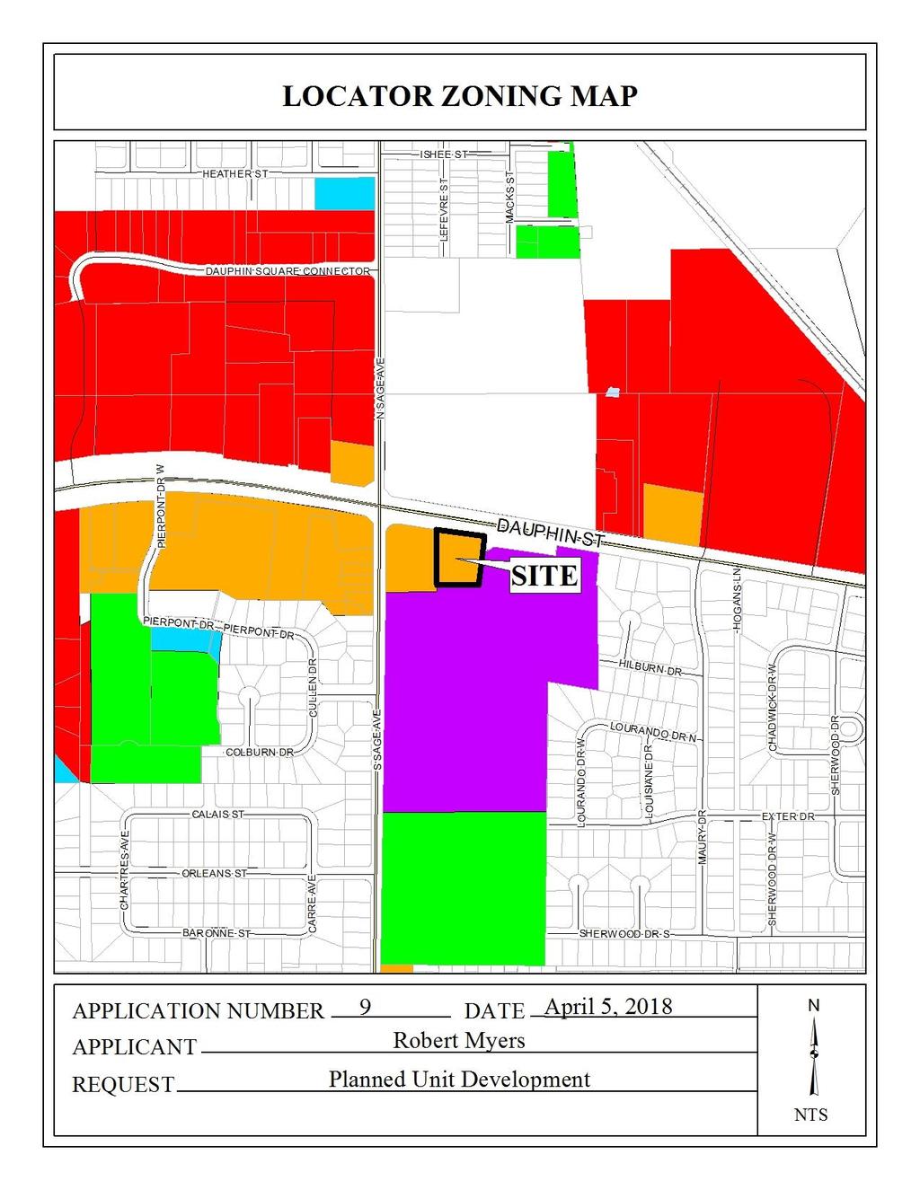
1 PLANNED UNIT DEVELOPMENT Date: April 5, 2018 DEVELOPMENT NAME SUBDIVISION NAME LOCATION Robert Myers Robert Myers 2955 and 2989 Dauphin Street (Southeast corner of Dauphin Street and Sage Avenue) CITY COUNCIL DISTRICT District 1 AREA OF PROPERTY CONTEMPLATED USE access between three lots. TIME SCHEDULE FOR DEVELOPMENT 1 Lot/ 1.7 ± Acres Planned Unit Development Approval to allow shared None given. ENGINEERING COMMENTS ADD THE FOLLOWING NOTES TO THE PUD SITE PLAN: 1. Any work performed in the existing ROW (right-of-way) such as driveways, sidewalks, utility connections, grading, drainage, irrigation, or landscaping will require a ROW permit from the City of Mobile Engineering Department ( ) and must comply with the City of Mobile Right-of-Way Construction and Administration Ordinance (Mobile City Code, Chapter 57, Article VIII). 2. A Land Disturbance Permit application shall be submitted for any proposed land disturbing activity with the property. A complete set of construction plans including, but not limited to, drainage, utilities, grading, storm water detention systems, paving, and all above ground structures, will need to be included with the Land Disturbance permit. This Permit must be submitted, approved, and issued prior to beginning any of the construction work. 3. Any and all proposed land disturbing activity within the property will need to be submitted for review and be in conformance with Mobile City Code, Chapter 17, Storm Water Management and Flood Control); the City of Mobile, Alabama Flood Plain Management Plan (1984); and, the Rules For Erosion and Sedimentation Control and Storm Water Runoff Control. 4. The approval of all applicable federal, state, and local agencies (including all storm water runoff, wetland and floodplain requirements) will be required prior to the issuance of a Land Disturbance permit. The Owner/Developer is responsible for acquiring all of the necessary permits and approvals. 5. The proposed development must comply with all Engineering Department design requirements and Policy Letters.
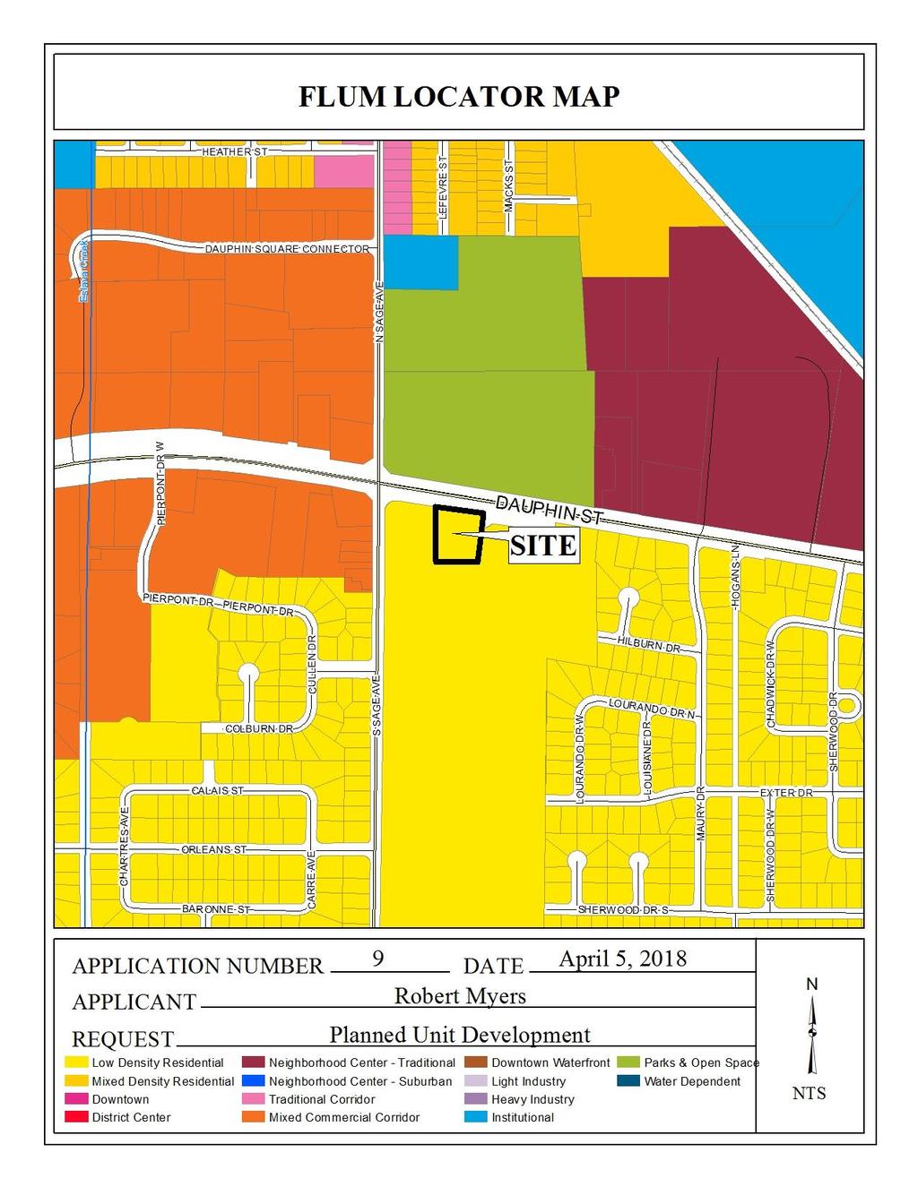
2 TRAFFIC ENGINEERING COMMENTS Proposed site is limited to one curb cut per street frontage, with size, location and design to be approved by Traffic Engineering and conform to AASHTO standards. Future access points will be determined with future phases of the planned unit development. Driveway access to Dauphin Street is limited to right-in, right-out only, whether it is aligned with a continuous median or a median opening. A traffic study will be required as determined by the Traffic Engineering Director upon further development of the site. A traffic study was performed with prior Planning Commission applications which required offsite improvements. There is no requirement at this time to conduct a traffic study, based on the proposed intensity of the site plan submitted. URBAN FORESTRY COMMENTS Property to be developed in compliance with state and local laws that pertain to tree preservation and protection on both city and private properties (State Act and City Code Chapters 57 and 64). FIRE DEPARTMENT COMMENTS All projects within the City Limits of Mobile shall comply with the requirements of the City of Mobile Fire Code Ordinance. (2012 International Fire Code). Projects outside the City Limits of Mobile, yet within the Planning Commission Jurisdiction fall under the State or County Fire Code. (2012 IFC). REMARKS The applicant is requesting Planned Unit Development Approval to amend a previously approved Planned Unit Development to allow shared access between three lots. The overall site was originally approved by the Planning Commission in May 2008 as a 5-lot Subdivision with Rezoning, and a Planned Unit Development. The site was approved again in December 2010 by the Planning Commission to amend a previously approved PUD to allow shared access between three lots. The site was approved a third time by the Commission in October 2016 to amend the previously approved PUD to allow shared access between three lots. No development has taken place, thus the previous PUD approvals have all expired. The applicant now wishes to submit a new PUD request to allow shared access between three lots with a slightingly different circulation layout. The site has been given a Low Density Residential land use designation, per the Future Land Use Plan and Map, adopted on May 18, 2017 by the Planning Commission. The Future Land Use Plan and Map complements and provides additional detail to the Development Framework Maps in the Map for Mobile, adopted by the Planning Commission at its November 5, 2015 meeting. This designation applies to existing residential neighborhoods found mostly west of the Beltline or immediately adjacent to the east side of the Beltline. The primary land use in the LDR districts is residential and the predominant housing type is the single-family housing unit, detached or semi-detached, typically placed within a street grid or a network of meandering suburban streets. The density in these districts ranges between 0 and 6 dwelling units per acre (du/ac)
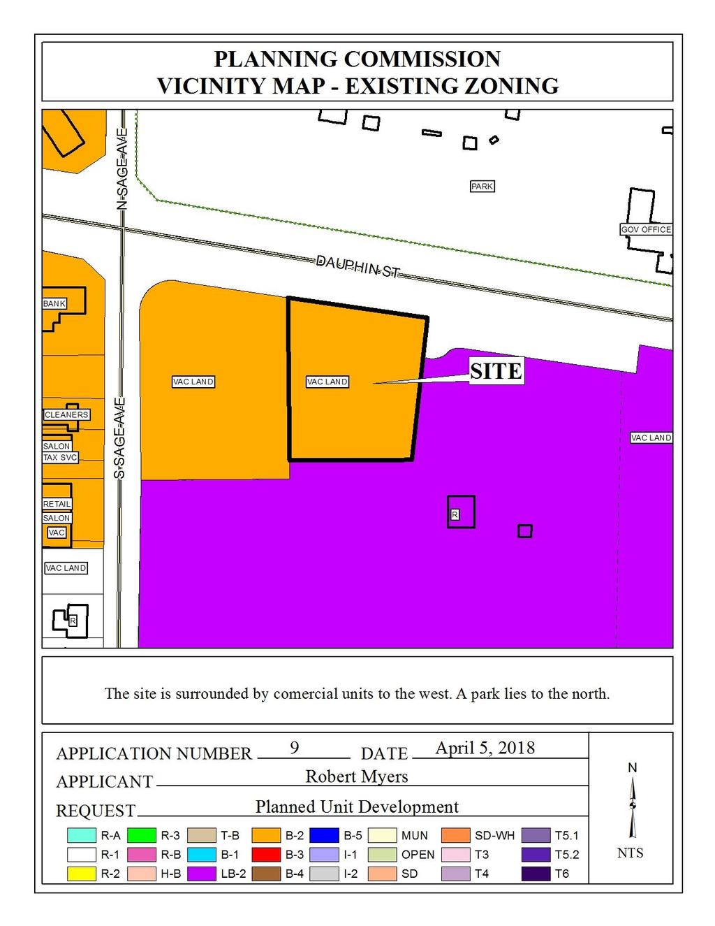
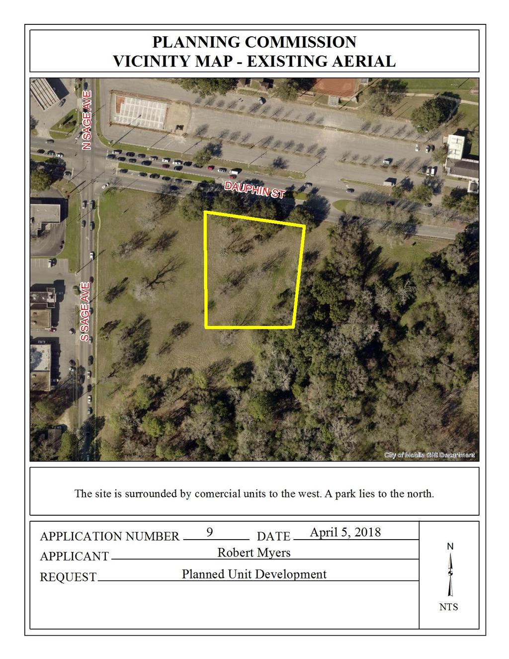
3 These neighborhoods may also contain small-scale, low-rise multi-unit structures at appropriate locations, as well as complementary retail, parks and civic institutions such as schools, community centers, neighborhood playgrounds, and churches or other religious uses if those uses are designed and sited in a manner compatible with and connected to the surrounding context. The presence of individual ancillary uses should contribute to the fabric of a complete neighborhood, developed at a walkable, bikeable human scale. Planned Unit Development review examines the site with regard to its location to ensure that it is generally compatible with neighboring uses; that adequate access is provided without generating excess traffic along minor residential streets in residential districts outside the PUD; and that natural features of the site are taken into consideration. PUD review also examines the design of the development to provide for adequate circulation within the development; to ensure adequate access for emergency vehicles; and to consider and provide for protection from adverse effects of adjacent properties as well as provide protection of adjacent properties from adverse effects from the PUD. In pursuit of these purposes, the objectives to be met by a PUD are as follows: a) to encourage innovative and diversified design in building form and site development; b) flexibility, to permit greater flexibility in the location and arrangement of buildings and uses than is generally possible under district regulations; c) to encourage the most efficient and sustainable use of land, especially tracts in the inner part of the city that remain undeveloped or that are appropriate for re-development; d) to preserve and protect as urban amenities the natural features and characteristics of land; e) to encourage the provision of common open space through efficient site design; and, f) to encourage optimum use of available public utilities, streets and community facilities. PUD approval is site-plan specific, thus any changes to the site plan will require approval by the Planning Commission. Also, PUD approvals expire within one (1) year if no permits for the development are obtained. The applicant proposes to construct a 3,604 square feet car wash accompanied with 36 vacuum stalls partially covered by sun shades, pay station, a canopy, an entrance awning, and one parking space for the car wash attendant. The lot fronts Dauphin Street, a major street according to the Major Street Plan component of the Comprehensive Plan, with a 120 right-of-way, which exceeds the 100 feet requirements, therefore no dedication will be required. The lot also has access to Sage Avenue via an access easement across two other lots that will be constructed and used to connect to Dauphin Street. The site plan depicts the right-of-way width along Sage Avenue as varying, however, information on the Final Plat, recorded in 2008, shows the right-of-way as 60 for Sage Avenue. The site plan should be revised to depict the accurate right-of-way width along this portion of Sage Avenue. The 25 minimum building setback line is depicted on the site plan for the lot being developed and should be retained on any future plans. 3
4 As a means of access management, the lot proposed for development should be limited to the curb-cuts as previously approved, that is, the lot will have a direct curb-cut to Dauphin Street, but will utilize one shared curb-cut to Dauphin and one curb-cut to Sage. All proposed parking areas for the site appear to be compliant in terms of travel aisle width, parking stall dimensions, and number of spaces; however, it should be pointed out that the site plan does not depict any accessible parking spaces/ vacuum stalls, therefore the site may not be in compliance with building code requirements and the Americans with Disabilities Act. The site plan should be revised to depict compliant accessible parking, which may include the provision of one accessible parking space and one accessible vacuum stall. A sidewalk is shown along the frontage of the site as well as proposed dumpster location. The illustrations should be retained on any revised PUD site plan, along with a note acknowledging compliance with Section 64-4.D.9. of the Zoning Ordinance regarding dumpster compliance. The site plan provides landscaping information and illustrates tree plantings, however the required amount of frontage trees for the site appear to be short. After allocations for the canopy overhang have been taken in account for the existing live oaks within the right-of-way, the site is still short 1 frontage tree. Adequate tree planting and landscaping for the remainder of the site is provided. A revised site plan depicting one additional frontage tree will be required. All revisions must comply with Section 64-4.E. of the Zoning Ordinance regarding tree and landscaping requirements. In regards to the proposed car wash, full carwash compliance of the Zoning Ordinance is required. As such, all water run-off must be directed to the sanitary sewer system, an oil separator must be provided, and vehicles must be screened from view with at 3-5 evergreen hedge and/or landscaped berm. Lighting is not illustrated on the site plan. Any new lighting on the site will have to comply with the requirements of Sections 64-4.A.2., 64-6.A.3.c., and 64-6.A.8. of the Zoning Ordinance. A note reflecting this requirement should appear on the site plan, and photometric plans will be required at the time of submittal for land disturbance. It should be pointed out that there was no signage information provided for the proposed site. If approved, the proposed development on Lot 2 will be limited to one freestanding sign and two wall signs. It should be noted that although the subject site has previously been approved, there has been no construction or development of this site since the initial approvals in 2008 (10 years ago). The site includes multiple lots as a part of the original PUD approval and, at the time of the initial approval, an overall conceptual plan was submitted identifying proposed uses and site development for each lot. Staff has been requiring conceptual plans for phased PUDs to allow the determination of total number of curb-cuts, anticipated parking space requirements, and landscaping requirements. Furthermore, since the most recent approval in 2016, the City has adopted the Future Land Use Map (FLUM) which recommends the subject site to be a low density residential land use. Based on the new plan for the Map for Mobile and the recently 4
5 adopted FLUM, it may be advisable to require a new conceptual PUD site plan for the entire site, that takes into account the recommendations of the FLUM for the property. RECOMMENDATION Planned Unit Development: Staff recommends the following Findings of Fact for Denial of the Planned Unit Development: a. it cannot be determined if the proposal does or does not promote the objective of Creative design (to encourage innovative and diversified design in building form and site development), as there is no overall plan for the development of the site; b. it cannot be determined if the proposal does or does not promote the objective of Flexibility (to permit greater flexibility in the location and arrangement of buildings and uses than is generally possible under district regulations), because there is no development plan outlining future development for the entire site for evaluation by the Planning Commission; c. it cannot be determined if the proposal does or does not promote the objective of Efficient land use (to encourage the most efficient and sustainable use of land, especially tracts in the inner part of the city that remain undeveloped or that are appropriate for redevelopment), as there is no overall development of the site; d. it cannot be determined if the proposal does or does not promote the objective of Environment (to preserve and protect as urban amenities the natural features and characteristics of the land), because there is no development plan outlining future development for the entire site for evaluation by the Planning Commission; e. it cannot be determined if the proposal does or does not promote the objective of Open space (to encourage the provision of common open space through efficient site design), as there is no overall plan for the development of the site; f. it cannot be determined if the proposal does or does not promote the objective of Public services (to encourage optimum use of available public utilities, streets and community facilities), as there is no overall plan for the development of the site. Based upon the preceding, the application is recommended for Denial, due to the following: 1. A development plan was not submitted to provide an overall master plan of proposed uses and developments within the entire PUD, thus the Planning Commission cannot adequately determine the required Findings of Facts; and 2. The FLUM adopted May 2017 recommends the subject site as a low density residential land use. 5
6 6
7 7
8 8

9 9
10 10
11 11
12 12
PLANNED UNIT DEVELOPMENT STAFF REPORT Date: June 2, 2016
 # 9 ZON2016-01032 PLANNED UNIT DEVELOPMENT STAFF REPORT Date: June 2, 2016 DEVELOPMENT NAME JJT Properties LLC LOCATION 1147 & 1151 East I-65 Service Road South and 1180 Sledge Drive (Southeast corner
PLANNED UNIT DEVELOPMENT & SUBDIVISION STAFF REPORT Date: May 18, 2017
 & PUD-0000102-2017 PLANNED UNIT DEVELOPMENT & SUBDIVISION STAFF REPORT Date: May 18, 2017 NAME SUBDIVISION NAME Dauphin Creek Estates Subdivision Dauphin Creek Estates Subdivision LOCATION CITY COUNCIL
PLANNING APPROVAL & PLANNED UNIT DEVELOPMENT Date: November 2, 2017
 PLANNING APPROVAL & PLANNED UNIT DEVELOPMENT Date: November 2, 2017 DEVELOPMENT NAME LOCATION Mobile Christian School 5900 Cottage Hill Road (North side of Cottage Hill Road, 230 ± West of Freemont Drive
PLANNING APPROVAL & PLANNED UNIT DEVELOPMENT Date: April 6, 2017
 PLANNING APPROVAL & PLANNED UNIT DEVELOPMENT Date: April 6, 2017 DEVELOPMENT NAME LOCATION Mobile Christian School 5900 Cottage Hill Road (North side of Cottage Hill Road, 230 ± West of Freemont Drive
ZONING AMENDMENT & PLANNED UNIT DEVELOPMENT STAFF REPORT Date: April 4, 2013
 ZONING AMENDMENT & PLANNED UNIT DEVELOPMENT STAFF REPORT Date: April 4, 2013 NAME DEVELOPMENT NAME LOCATION DIP Exchange, LLC DIP Exchange, LLC 93 Sidney Phillips Drive (West side of Sidney Phillips Drive,
PLANNED UNIT DEVELOPMENT & PLANNING APPROVAL STAFF REPORT Date: April 4, 2013
 PLANNED UNIT DEVELOPMENT & PLANNING APPROVAL STAFF REPORT Date: April 4, 2013 NAME LOCATION The North American Islamic Trust, Inc. 63 East Drive (East side of East Drive, 400 South of Old Shell Road, and
THE CITY OF MOBILE, ALABAMA
 THE CITY OF MOBILE, ALABAMA LETTER OF DECISION Ark of Safety, Inc. Mobile, AL 36617 Re: (Northwest corner of Main Street and First Avenue, extending to the Southwest corner of Esau Avenue and Main Street.)
PLANNING APPROVAL & SIDEWALK WAIVER STAFF REPORT Date: December 1, 2016
 PLANNING APPROVAL & SIDEWALK WAIVER STAFF REPORT Date: December 1, 2016 NAME Dennis P. Wilkins LOCATION. CITY COUNCIL DISTRICT District 6 7078 Bruns Drive (Northeast corner of Bruns Drive and Cody Road)
PLANNED UNIT DEVELOPMENT & SUBDIVISION STAFF REPORT Date: March 15, 2012
 PLANNED UNIT DEVELOPMENT & SUBDIVISION STAFF REPORT Date: March 15, 2012 DEVELOPMENT NAME SUBDIVISION NAME LOCATION OSR Subdivision OSR Subdivision 5559 Old Shell Road (South side of Old Shell Road, 570
SUBDIVISION, PLANNED UNIT DEVELOPMENT, PLANNING APPROVAL, REZONING & SIDEWALK WAIVER STAFF REPORT Date: February 7, 2013
 SUBDIVISION, PLANNED UNIT DEVELOPMENT, PLANNING APPROVAL, REZONING & SIDEWALK WAIVER STAFF REPORT Date: February 7, 2013 APPLICANT NAME SUBDIVISION NAME DEVELOPMENT NAME LOCATION S. E. Cemeteries of AL
PLANNED UNIT DEVELOPMENT Date: May 4, 2017
 PLANNED UNIT DEVELOPMENT Date: May 4, 2017 DEVELOPMENT NAME LOCATION Sarah & Michael Stashak 2165 & 2167 Old Shell Road (South side of Old Shell Road, at the Southern terminus of Frazier Court) CITY COUNCIL
ZONING AMENDMENT, PLANNED UNIT DEVELOPMENT & SUBDIVISION STAFF REPORT Date: March 20, 2008
 ZONING AMENDMENT, PLANNED UNIT DEVELOPMENT & SUBDIVISION STAFF REPORT Date: March 20, 2008 NAME SUBDIVISION NAME LOCATION Joseph Mramor Mramor s Addition to Weinacker Avenue Subdivision 900 Weinacker Avenue
# 3 & 4 HOLDOVER ZON & ZON PLANNED UNIT DEVELOPMENT & PLANNING APPROVAL STAFF REPORT Date: June 4, 2009
 PLANNED UNIT DEVELOPMENT & PLANNING APPROVAL STAFF REPORT Date: June 4, 2009 NAME LOCATION Mobile Carnival Association, Inc. 561 Stuart Circle (South side of Bloodgood Street at its West terminus) CITY
# 17 & 18 ZON & ZON PLANNED UNIT DEVELOPMENT & PLANNING APPROVAL STAFF REPORT Date: February 5, Mobile Carnival Association
 PLANNED UNIT DEVELOPMENT & PLANNING APPROVAL STAFF REPORT Date: February 5, 2009 NAME LOCATION Mobile Carnival Association South side of Bloodgood Street at its West terminus CITY COUNCIL DISTRICT District
PLANNING APPROVAL STAFF REPORT Date: November 17, 2011
 # 11 ZON2011-02680 PLANNING APPROVAL STAFF REPORT Date: November 17, 2011 NAME LOCATION Alabama Power Company East side of Navco Road 130 ± South of Columbus Avenue CITY COUNCIL DISTRICT District 4 PRESENT
SUBDIVISION PLANNED UNIT DEVELOPMENT & REZONING STAFF REPORT Date: May 5, 2016
 SUBDIVISION PLANNED UNIT DEVELOPMENT & REZONING STAFF REPORT Date: May 5, 2016 DEVELOPMENT NAME LOCATION LOCATION Midtown Mobile Subdivision IRC-Mobile Midtown, LLC 100 North Florida Street & 2518, 2524,
CITY OF MOBILE MOBILE CITY PLANNING COMMISSION LETTER OF DECISION. November 5, 2012
 SAMUEL L. JONES MAYOR CITY OF MOBILE LETTER OF DECISION OFFICE OF THE CITYCOUNCIL COUNCIL MEMBERS REGGIE COPELAND, SR. PRESIDENT-DISTRICT 5 FREDRICK D. RICHARDSON, JR. VICE PRESIDENT-DISTRICT 1 WILLIAM
SUBDIVISION, REZONING, PLANNING APPROVAL, PUD & SIDEWALK WAIVER STAFF REPORT Date: May 3, 2007
 SUBDIVISION, REZONING, PLANNING APPROVAL, PUD & SIDEWALK WAIVER STAFF REPORT Date: May 3, 2007 APPLICANT NAME SUBDIVISION NAME LOCATION TOG Properties, LLC Highland Professional Park, Resubdivision of
MOBILE CITY PLANNING COMMISSION LETTER OF DECISION. October 22, 2010
 MOBILE CITY PLANNING COMMISSION LETTER OF DECISION Archbishop of Mobile 400 Government St. Mobile, AL 36602 Re: Case #SUB2010-00075 (Subdivision) 3650 Springhill Avenue (Northwest corner of Springhill
ARTICLE 6: Special and Planned Development Districts
 ARTICLE 6: Special and Planned Development Districts 6-10 Traditional Neighborhood Development (TND) District 6-10.10 Purpose and Intent The Traditional Neighborhood Development (TND) District provides
Request Conditional Use Permit (Car Wash Facility) Staff Recommendation Approval. Staff Planner Jonathan Sanders
 Staff Recommendation Approval. Staff Planner Jonathan Sanders") Applicant Property Owner SunTrust Bank Public Hearing October 10, 2018 City Council Election District Princess Anne Agenda Item 2 Request Conditional Use Permit (Car Wash Facility) Staff Recommendation
Applicant Property Owner SunTrust Bank Public Hearing October 10, 2018 City Council Election District Princess Anne Agenda Item 2 Request Conditional Use Permit (Car Wash Facility) Staff Recommendation
Urban Planning and Land Use
 Urban Planning and Land Use 701 North 7 th Street, Room 423 Phone: (913) 573-5750 Kansas City, Kansas 66101 Fax: (913) 573-5796 Email: planninginfo@wycokck.org www.wycokck.org/planning To: From: City Planning
AWH REPORT OF THE PLANNING AND DEVELOPMENT DEPARTMENT FOR APPLICATION FOR REZONING ORDINANCE TO PLANNED UNIT DEVELOPMENT
 AWH REPORT OF THE PLANNING AND DEVELOPMENT DEPARTMENT FOR APPLICATION FOR REZONING ORDINANCE TO PLANNED UNIT DEVELOPMENT MAY 8, 2014 The Planning and Development Department hereby forwards to the Planning
REZONING APPLICATION MPD SUPPLEMENT
 REZONING APPLICATION MPD SUPPLEMENT For Staff Use Only: DATE/TIMESTAMP: ZA# RECEIVED BY: The intent of the Master Planned District (MPD) designation is to allow flexibility in the design and construction
Urban Planning and Land Use
 Urban Planning and Land Use 701 North 7 th Street, Room 423 Phone: (913) 573-5750 Kansas City, Kansas 66101 Fax: (913) 573-5796 Email: planninginfo@wycokck.org www.wycokck.org/planning To: From: City Planning
Urban Planning and Land Use
 Urban Planning and Land Use 701 North 7 th Street, Room 423 Phone: (913) 573-5750 Kansas City, Kansas 66101 Fax: (913) 573-5796 Email: planninginfo@wycokck.org www.wycokck.org/planning To: From: City Planning
Agenda Item. Applicant Logan Virginia Properties, LLC Property Owners Byler Azalea, LLC & Gateway Free Will Baptist Chuch
 Applicant Property Owners Byler Azalea, LLC & Gateway Free Will Baptist Chuch Public Hearing March 14, 2018 City Council Election District Kempsville Agenda Item 6 Request Conditional Rezoning (B-2 Community
6 November 13, 2013 Public Hearing APPLICANT: CAH HOLDINGS, LLC
 6 November 13, 2013 Public Hearing APPLICANT:, LLC PROPERTY OWNER: LC REALTY, LLC STAFF PLANNER: Kevin Kemp REQUEST: Conditional Use Permit (Automated Car Wash) ADDRESS / DESCRIPTION: 3565 Holland Road
8 8 CITY OF MOBILE MOBILE CITY PLANNING COMMISSION LETTER OF DECISION. November 5, 2012
 SAMUEL L. JONES 8 8 November 5, 2012 PRESIDENT-DISTRICT S FREDRICK D. RICHARDSON, JR. VICE PRESIDENT-DISTRICT I JOHN C. WILLIAMS DISTRICT4 DISTRICT6 DISTRICT 7 Cummings Architecture Corporation Case #SUB2012-00087
SITE PLAN REVIEW ITEMS - REFERENCE CHECKLIST
 City of Seminole 9199 113 th Street N. Seminole, FL 33772 Ph: (727) 392-1966 Fx: (727) 319-6583 SITE PLAN REVIEW ITEMS - REFERENCE CHECKLIST Note: This checklist is designed to aid designers in the review
VILLAGE OF CLEMMONS PLANNING BOARD DRAFT STAFF REPORT
 VILLAGE OF CLEMMONS PLANNING BOARD DRAFT STAFF REPORT PETITION INFORMATION Docket # C-226 Staff Megan Ledbetter Petitioner(s) JBJH Properties, LLC Owner(s) JBJH Properties, LLC Subject Property 5892-49-1766
VILLAGE OF CLEMMONS PLANNING BOARD DRAFT STAFF REPORT. Single Family Residential, Townhomes
 VILLAGE OF CLEMMONS PLANNING BOARD DRAFT STAFF REPORT PETITION INFORMATION Docket # C-212 Staff Megan Ledbetter Petitioner(s) Peacehaven Development LLC Owner(s) Larry Jarvis, William Alexander and Peacehaven
PLANNING APPROVAL STAFF REPORT Date: October 5, 2006
 PLANNING APPROVAL STAFF REPORT Date: October 5, 2006 NAME LOCATION Corpus Christi School 6300 McKenna Drive (North side of McKenna Drive at the North termini of Evergreen Road and Hillview Road) CITY COUNCIL
APPLICATION FOR REZONING PROPERTY CITY OF HOLLAND, MICHIGAN. Name of Applicant. Address, and Phone # of Applicant
 APPLICATION FOR REZONING PROPERTY CITY OF HOLLAND, MICHIGAN Name of Applicant Address, Email and Phone # of Applicant Name and Address of Owner (if other than applicant) Ownership Interest of Applicant
12 January 12, 2011 Public Hearing APPLICANT: TAILWIND DEVELOPMENT GROUP,LLC PROPERTY OWNER: CITY OF VIRGINIA BEACH
 12 January 12, 2011 Public Hearing APPLICANT: TAILWIND DEVELOPMENT GROUP,LLC PROPERTY OWNER: CITY OF VIRGINIA BEACH STAFF PLANNER: Faith Christie REQUEST: Conditional Change of Zoning (from PD-H1 Planned
Planning Commission Staff Report June 5, 2008
 Owner/Applicant Taylor Village Sacramento Investments Partners, LP c/o Kim Whitney 1792 Tribute Road #270 Sacramento, CA 95815 Staff Recommendation Planning Commission Staff Report Project: File: Request:
STORMWATER MANAGEMENT CODES ANALYSIS RICHLAND COUNTY, SC SITE PLANNING ROUNDTABLE
 STORMWATER MANAGEMENT CODES ANALYSIS RICHLAND COUNTY, SC SITE PLANNING ROUNDTABLE Codes analyses for each subcommittee were completed to assist participants of the Richland County Site Planning Roundtable.
Zoning Ordinance Chapter 10
 CHAPTER 10 - WASHES SECTION 10.0 GENERAL: A. The purpose of this Ordinance is to establish standards for development in or near Major and Minor Washes as defined in Appendix A Glossary of Terms and Definitions
ADMINISTRATION RECOMMENDATION 2016 November 03. That Calgary Planning Commission recommends APPROVAL of the proposed Land Use Amendment.
 Page 1 of 12 EXECUTIVE SUMMARY This Land Use Amendment application covers an area of 75.76 hectares ± (187.20 acres ±) located in northeast Calgary, bound by Stoney Trail NE to the north, 128 Avenue NE
Request Alternative Compliance to the prescribed criteria of the Oceanfront Resort District Form-Based Code. Staff Planner Kristine Gay
 Applicant/Owner Ocean Rental Properties, LLC Public Hearing April 13, 2016 City Council Election District Beach Agenda Item 1 Request Alternative Compliance to the prescribed criteria of the Oceanfront
ARTICLE V PLANNED UNIT DEVELOPMENT DISTRICT
 ARTICLE V PLANNED UNIT DEVELOPMENT DISTRICT A. Purpose and Objective The Planned Unit Development (PUD) procedure provides a flexible land use and design regulation through the use of performance criteria
Town of Windham. Planning Department 8 School Road Windham, ME voice fax
 Town of Windham Planning Department 8 School Road Windham, ME 04062 voice 207.864-5960 fax 207.892.1916 MEMO DATE: TO: Staff Review Committee FROM: Amanda Lessard, Planner Cc: Ellen Rathbone, St. Germain
CITY-COUNTY PLANNING BOARD DRAFT STAFF REPORT
 CITY-COUNTY PLANNING BOARD DRAFT STAFF REPORT PETITION INFORMATION Docket # W-3174 Staff Aaron King Petitioner(s) O Reilly Auto Parts Owner(s) Glenn Crossing Associates, LLC Subject Property Portion of
Request Conditional Rezoning (R-15 Residential to Conditional B-2 Community Business) Staff Planner Kevin Kemp
 Staff Planner Kevin Kemp") Applicant Property Owner Three Five Ministries, Inc. Public Hearing May 11, 2016 City Council Election District Lynnhaven Agenda Item 4 Request Conditional Rezoning (R-15 Residential to Conditional B-2
Applicant Property Owner Three Five Ministries, Inc. Public Hearing May 11, 2016 City Council Election District Lynnhaven Agenda Item 4 Request Conditional Rezoning (R-15 Residential to Conditional B-2
City Development Department 9500 Civic Center Drive Thornton, Colorado FAX
 City Hall City Development Department 9500 Civic Center Drive 303-538-7295 Thornton, Colorado 80229-4326 FAX 303-538-7373 www.cityofthornton.net Ben Swanson Dormie Capital Partners 3740 Dacoro Lane, Suite
General Location Courtyard at LMH Final Development Plan and Final Plat
 R-1 LEYDEN RIDGE LOMA RIDGE LOBDELL R-3 MILLER PARKWAY LAUSSAC Subject Property R-3 LOCHENSHIRE LESMER R General Location Courtyard at LMH Final Development Plan and Final Plat ¹ 230 115 0 230 Feet Airport
CITY COUNCIL STUDY SESSION MEMORANDUM
 City and County of Broomfield, Colorado CITY COUNCIL STUDY SESSION MEMORANDUM To: From: Prepared by: Mayor and City Council Charles Ozaki, City and County Manager Kevin Standbridge, Deputy City and County
Request Change in Nonconformity. Staff Recommendation Approval. Staff Planner Jonathan Sanders
 Applicant & Owner Public Hearing April 11, 2018 City Council Election District Beach Agenda Item 5 Request Change in Nonconformity Staff Recommendation Approval Staff Planner Jonathan Sanders Location
BOULEVARD AND PARKWAY STANDARDS
 88-323 BOULEVARD AND PARKWAY STANDARDS 88-323-01 PURPOSE Considerable public and private investment exists and is expected to occur adjacent to boulevards and parkways within the city. The following standards
ARTICLE 17 SITE PLAN REVIEW
 ARTICLE 17 SITE PLAN REVIEW 17.01 INTENT AND PURPOSE The intent of this section is to provide for consultation and cooperation between the applicant and the township planning commission so that the applicant
VILLAGE OF CLEMMONS PLANNING BOARD DRAFT STAFF REPORT
 VILLAGE OF CLEMMONS PLANNING BOARD DRAFT STAFF REPORT PETITION INFORMATION Docket # C-214 Staff Megan Ledbetter Petitioner(s) Summit Healthcare Group Owner(s) Wake Forest University Health Services Subject
13. PRELIMINARY PLAT NO MILLS FARM - Vicinity of the southeast corner of 159 th Street and Quivira Road
 13. corner of 159 th Street and Quivira Road 1. APPLICANT: HNTB Corporation is the applicant for this request. 2. REQUESTED ACTION: The applicant is requesting approval of a preliminary plat for a 383-lot
Request Modification of Conditions (Automobile Service Station) Staff Recommendation Approval. Staff Planner Jimmy McNamara
 Staff Recommendation Approval. Staff Planner Jimmy McNamara") Applicant Larae Tucker Property Owner Doswell Ventures, LLC Public Hearing May 10, 2017 City Council Election District Princess Anne Agenda Item 3 Request Modification of Conditions (Automobile Service
Applicant Larae Tucker Property Owner Doswell Ventures, LLC Public Hearing May 10, 2017 City Council Election District Princess Anne Agenda Item 3 Request Modification of Conditions (Automobile Service
Request Conditional Rezoning (R-10 Residential & I-1 Light Industrial to Conditional I-1 Light Industrial) Staff Recommendation Approval
 Staff Recommendation Approval") Applicant & Property Owner Public Hearing January 9, 2019 City Council Election District Beach Agenda Item 1 Request Conditional Rezoning (R-10 Residential & I-1 Light Industrial to Conditional I-1 Light
Applicant & Property Owner Public Hearing January 9, 2019 City Council Election District Beach Agenda Item 1 Request Conditional Rezoning (R-10 Residential & I-1 Light Industrial to Conditional I-1 Light
GENERAL INFORMATIONaaaaaaaaaaaaaaaaaaaaaaaaaaaaaaaa
 To: Planning and Zoning Commission From: City Staff Date: November 15, 2016 Re: Case #16026 Raymore Activity Center Site Plan GENERAL INFORMATIONaaaaaaaaaaaaaaaaaaaaaaaaaaaaaaaa Applicant/ Property Owner:
MONTGOMERY COUNTY PLANNING DEPARTMENT THE MARYLAND-NATIONAL CAPITAL PARK AND PLANNING COMMISSION
 MONTGOMERY COUNTY PLANNING DEPARTMENT THE MARYLAND-NATIONAL CAPITAL PARK AND PLANNING COMMISSION MCPB Item No. Date: 12-10-15 Leisure World Clubhouse II Addition Fitness Center, Limited Site Plan Amendment
North Oakville East Parks Facilities Distribution Plan. November, 2009
 North Oakville East November, 2009 POLICY CONTEXT 1) Purpose a) The purpose of this document is to be a guide for the location, configuration, design and development of the parks system for the North Oakville
Request Conditional Use Permit (Automobile Service Station) Staff Recommendation Approval. Staff Planner Bill Landfair
 Staff Recommendation Approval. Staff Planner Bill Landfair") Applicant Property Owner RTR Real Estate Associates, Tidewater Investments, LLC, Bruce Ranomski Public Hearing December 12, 2018 City Council Election District Centerville Agenda Item 7 Request Conditional
Applicant Property Owner RTR Real Estate Associates, Tidewater Investments, LLC, Bruce Ranomski Public Hearing December 12, 2018 City Council Election District Centerville Agenda Item 7 Request Conditional
11 March 9, 2011 Public Hearing APPLICANT: BUDDHIST EDUCATION CENTER OF AMERICA DONG HUNG TEMPLE, INC. PROPERTY OWNER: MOY FAMILY, LLC
 11 March 9, 2011 Public Hearing APPLICANT: BUDDHIST EDUCATION CENTER OF AMERICA DONG HUNG TEMPLE, INC. PROPERTY OWNER: MOY FAMILY, LLC REQUEST: Conditional Use Permit for Religious use STAFF PLANNER: Karen
Mitchell Ranch South MPUD Application for Master Planned Unit Development Approval Project Narrative. Introduction
 Mitchell Ranch South MPUD Application for Master Planned Unit Development Approval Project Narrative Introduction Mitchell Ranch South is a proposed single family (detached) residential development on
PART 1: PROJECT SUMMARY. Proposed Land Use: 120 single-family lots. The application is Attachment A. The site plan is Attachment B.
 PART 1: PROJECT SUMMARY Applicant: JBH Development, LLC and Hopper Communities, INC Project Size: +/- 80.48 acres Parcel Number: 01513107, 01513108, 01513109, 01513113, 01513120, 01513121, 01513122, 01513124,
Colerain Township report to. Hamilton County Regional Planning Commission. December 2, 2010, 1:00PM. t a f f r e p o r t
 Colerain Township report to Hamilton County Regional Planning Commission December 2, 2010, 1:00PM Preliminary Plan: Case No.: ZA2001-04, Forevergreen Prepared By: Amy Bancroft, Land Use Planner t a f f
SITE PLAN REVIEW APPLICATION AND CHECKLIST
 SITE PLAN REVIEW APPLICATION AND CHECKLIST PROJECT SUMMARY: Project Name: City/ETA Location: City ETA (Application fee & number of copies needed are based on location) Property Location (Legal Description
NEW CASTLE COUNTY S ZONING DISTRICTS
 NEW CASTLE COUNTY S ZONING DISTRICTS This is general information about New Castle County s zoning districts. The information included is by no means exhaustive or complete. Before designing plans to develop
#16 ) FDP THE HABIT BURGER GRILL FINAL DEVELOPMENT PLAN
 FDP THE HABIT BURGER GRILL FINAL DEVELOPMENT PLAN") STAFF REPORT #16 ) FDP-02-17 THE HABIT BURGER GRILL FINAL DEVELOPMENT PLAN To: Planning Commission Meeting date: February 8, 2017 Item: FDP-02-17 Prepared by: Johanna Murphy GENERAL INFORMATION: Applicant:
STAFF REPORT #16 ) FDP-02-17 THE HABIT BURGER GRILL FINAL DEVELOPMENT PLAN To: Planning Commission Meeting date: February 8, 2017 Item: FDP-02-17 Prepared by: Johanna Murphy GENERAL INFORMATION: Applicant:
Rezoning Petition Pre-Hearing Staff Analysis September 17, 2018
 Rezoning Petition 2017-043 Pre-Hearing Staff Analysis September 17, 2018 REQUEST Current Zoning: R-3 (single family residential), R-17MF (multi-family residential), and CC (commercial center) Proposed
Asbury Chapel Subdivision Sketch Plan
 Asbury Chapel Subdivision Sketch Plan PART 1: PROJECT SUMMARY Applicant: NVR Inc. Project Size: +/- 76.13 acres Parcel Numbers: 02101112,02116101,02116112, 02116113 Current Zoning: Transitional Residential
Application for Site Plan Review
 Application for Site Plan Review City of Pontiac Office of Land Use and Strategic Planning 47450 Woodward Ave, Pontiac, MI 48342 T: 248.758.2800 F: 248.758.2827 Property/Project Address: Sidwell Number:
LAND USE AMENDMENT CORNERSTONE (WARD 3) COUNTRY HILLS BOULEVARD AND STONEY TRAIL NE BYLAW 9D2017
 COUNTRY HILLS BOULEVARD AND STONEY TRAIL NE BYLAW 9D2017") Page 1 of 12 EXECUTIVE SUMMARY This Land Use Amendment application covers an area of 54.92 hectares ± (135.71 acres ±) located in northeast Calgary, bound by Country Hills Boulevard NE to the north and
Page 1 of 12 EXECUTIVE SUMMARY This Land Use Amendment application covers an area of 54.92 hectares ± (135.71 acres ±) located in northeast Calgary, bound by Country Hills Boulevard NE to the north and
Town of West Point Plan of Development
 Town of West Point Plan of Development Plan Submission In accordance with Section 70-51(b) of the Town Code, the Zoning Administrator shall establish a written policy for the form, format, content and
Planning & Development. Background. Subject Lands
 Planning & Development APPLICATION BRIEFING Prepared For: Planning Advisory Committee Submitted by: Jason Fox, Director of Planning & Development Date: Subject: Development Agreement Application by Brentwood
City of Mt. Juliet Planning & Zoning Department. Site Plan Checklist. Site plan cklist v1.18
 City of Mt. Juliet Planning & Zoning Department Site Plan Checklist Site Plan approval is required for all specified community facilities, all commercial, industrial, and multi-family residential activities
LAND USE AMENDMENT CORNERSTONE (WARD 3) 60 STREET NE AND COUNTRY HILLS BOULEVARD NE MAP 26NE BYLAW 22D2017
 60 STREET NE AND COUNTRY HILLS BOULEVARD NE MAP 26NE BYLAW 22D2017") Page 1 of 14 EXECUTIVE SUMMARY This Land Use Amendment application covers an area of 43.76 hectares ± (108.14 acres ±) located in northeast Calgary, bound by Country Hills Boulevard NE to the south and
Page 1 of 14 EXECUTIVE SUMMARY This Land Use Amendment application covers an area of 43.76 hectares ± (108.14 acres ±) located in northeast Calgary, bound by Country Hills Boulevard NE to the south and
Preliminary Development Plan 07/ /2
 OWENSBORO METROPOLITAN PLANNING COMMISSION Preliminary Development Plan 07/06 120 1/2 Development Information The table at right refers to the application materials required for submission, unless otherwise
Planning & Zoning Commission Meeting Date: June 04, 2012
 Meeting Date: June 04, 2012 Request Applicant Owner Zoning Preliminary/Final Plat of 24.114 acres of unplatted property into one lot with one reserve for landscape/open space. Extension of infrastructure
Major Development Plan
 Major Development Plan Application number: MDP2016.03 Nixon Road Subdivision Request: The applicant request that the City Council receive the planning board recommendation to approve with conditions a
PLANNED UNIT DEVELOPMENT PUD For The Proposed Antietam Subdivision Escambia County, Florida. Introduction
 PLANNED UNIT DEVELOPMENT PUD For The Proposed Antietam Subdivision Escambia County, Florida Introduction The project is located in Escambia County approximately 0.75 + miles north of the US Highway 90,
TOP TEN LIST OF COMMUNITY CONCERNS REGARDING PROPOSED AMENDMENTS TO CHAPTER 42
 TOP TEN LIST OF COMMUNITY CONCERNS REGARDING PROPOSED AMENDMENTS TO CHAPTER 42 1. Extend the urban area to Beltway 8 in stages, over say a three-year period, prioritizing development in transit and declining
CONSENT CALENDAR CITY PLANNING COMMISSION AGENDA ITEM NO: A.1, A.2 STAFF: LARRY LARSEN
 Page 8 CONSENT CALENDAR CITY PLANNING COMMISSION AGENDA ITEM NO: A.1, A.2 STAFF: LARRY LARSEN FILE NO: CPC PUZ 14-00013 - QUASI-JUDICIAL FILE NO: CPC PUD 14-00014 QUASI-JUDICIAL PROJECT: APPLICANT: OWNER:
PART 1: PROJECT SUMMARY. The application is Attachment A. The site plan is Attachment B.
 Belleterre Subdivision Sketch Plan Town Board 8.7.17 Belleterre Subdivision Sketch Plan PART 1: PROJECT SUMMARY Applicant: Bowman Development Project Size: +/- 20.85 acres Parcel Number: 01115104 and 01115121
SUBMITTAL REQUIREMENTS: FINAL PLAN REVIEW- PROJECT DEVELOPMENT PLAN (PDP)
") 1) Application form and filing fee. Application Form.pdf Development Review Guide STEP 6 of 8 SUBMITTAL REQUIREMENTS: FINAL PLAN REVIEW- PROJECT DEVELOPMENT PLAN (PDP) 2) Transportation Development Review
1) Application form and filing fee. Application Form.pdf Development Review Guide STEP 6 of 8 SUBMITTAL REQUIREMENTS: FINAL PLAN REVIEW- PROJECT DEVELOPMENT PLAN (PDP) 2) Transportation Development Review
Checklists. Project Name: Location: File Number: Date of Submittal: Reviewer: Date: Applicant: Contact Name: Phone Number:
 Applicant: Contact Name: Phone Number: Email: Project Name: Location: File Number: Date of Submittal: Reviewer: Date: Concept Plan Requirements: I. General Project Information 1. Address or parcel number
Rezoning Petition Pre-Hearing Staff Analysis April 16, 2018
 Rezoning Petition 2018-015 Pre-Hearing Staff Analysis April 16, 2018 REQUEST LOCATION Current Zoning: R-4 (single family residential) and UR-2(CD) (urban residential, conditional) Proposed Zoning: UR-2(CD)
14 October 10, 2012 Public Hearing APPLICANT: MPB, INC
 14 October 10, 2012 Public Hearing APPLICANT: MPB, INC PROPERTY OWNER: MUNDEN & ASSOCIATES, LP STAFF PLANNER: Karen Prochilo REQUEST: Conditional Change of Zoning (AG-1 & AG-2 to Conditional O-2) ADDRESS
CASE NUMBER: 15SN0594 APPLICANT: Racetrack Petroleum, Inc.
 CASE NUMBER: 15SN0594 APPLICANT: Racetrack Petroleum, Inc. STAFF S ANALYSIS AND RECOMMENDATION Board of Supervisors (BOS) Public Hearing Date: DECEMBER 10, 2014 BOS Time Remaining: 365 DAYS Applicant s
7 February 9, 2011 Public Hearing APPLICANT: 7-ELEVEN, INC.
 7 February 9, 2011 Public Hearing APPLICANT: PROPERTY OWNER: COURTHOUSE MARKETPLACE OUTPARCELS, L.L.C. STAFF PLANNER: Faith Christie REQUEST: Modification of Conditional Change of Zoning approved by the
Request Conditional Use Permit (Automobile Repair Garage) Staff Planner Kevin Kemp
 Staff Planner Kevin Kemp") Request Conditional Use Permit (Automobile Repair Garage) Staff Planner Kevin Kemp Location 845 Lynnhaven Parkway GPIN 14963473030000 Election District Rose Hall Site Size 0.40 acre portion of a 6.35 acre
Request Conditional Use Permit (Automobile Repair Garage) Staff Planner Kevin Kemp Location 845 Lynnhaven Parkway GPIN 14963473030000 Election District Rose Hall Site Size 0.40 acre portion of a 6.35 acre
8 February 9, 2011 Public Hearing APPLICANT: 7-ELEVEN, INC.
 . 8 February 9, 2011 Public Hearing APPLICANT: REQUEST: Conditional Use Permit for an automobile service station with a convenience store ADDRESS / DESCRIPTION: 2448 Nimmo Parkway PROPERTY OWNER: COURTHOUSE
Rapid City Planning Commission Rezoning Project Report
 Rapid City Planning Commission Rezoning Project Report July 21, 2016 Applicant Request(s) Case # 16RZ022 Rezoning from Office Commercial District to Light Industrial District Companion Case(s): 16RZ023-Rezoning
M E M O R A N D U M July 27, 2018
 M E M O R A N D U M July 27, 2018 To: Southlake 2035 Corridor Planning Committee From: Kenneth Baker, Sr. Director of Planning and Development Services Subject: Item #6 First National Bank Purpose Review,
Proposed Walkability Ordinance for City of Knoxville (6/16/17)
") Proposed Walkability Ordinance for City of Knoxville (6/16/17) New or revised text is highlighted Section 1: Purpose The purpose of this ordinance is to set requirements for walkability and pedestrian
Proposed Walkability Ordinance for City of Knoxville (6/16/17) New or revised text is highlighted Section 1: Purpose The purpose of this ordinance is to set requirements for walkability and pedestrian
Approved: CITY OF ARDEN HILLS, MINNESOTA PLANNING COMMISSION WEDNESDAY, AUGUST 5, :30 P.M. - ARDEN HILLS CITY HALL
 Approved: CITY OF ARDEN HILLS, MINNESOTA PLANNING COMMISSION WEDNESDAY, AUGUST 5, 2015 6:30 P.M. - ARDEN HILLS CITY HALL PLANNING CASES A. Planning Case 15-016; Final Planned Unit Development Arden Plaza;
Planning & Zoning Commission Meeting Date: June 18, 2012
 Meeting Date: June 18, 2012 Request Applicant Owner Zoning Location Attachments Proposed Master Plan for 11.5 acres of undeveloped property in the Tuscan Lakes PUD. The land is platted as one lot, and
Urban Planning and Land Use
 Urban Planning and Land Use 701 North 7 th Street, Room 423 Phone: (913) 573-5750 Kansas City, Kansas 66101 Fax: (913) 573-5796 Email: planninginfo@wycokck.org www.wycokck.org/planning To: From: City Planning
Landscaping Standards
 CHAPTER 29 ARTICLE 403 29.403 Landscaping Standards Purpose: The purpose of this section is to protect and promote the public health, safety and general welfare by requiring landscaping in relation to
Watertown City Council
 City of Watertown Watertown City Council April 14 th, 2015 Agenda Item: City Comment on Sun Share CUP Application Request for Action: Motion to Approve City Comments regarding CUP Application Department:
Denton Planning Commission. Minutes. Town of Denton. November 29, 2016
 Denton Planning Commission Minutes Town of Denton Planning Commission Members: Doris Walls, Chairperson* William Quick* Sue Cruickshank* Marina Dowdall* Dean Danielson *** Nicholas T. Iliff, Jr.* * Those
DRAFT Northeast Quadrant of Kipling Avenue and Highway 7 DRAFT AUGUST 29, Goals Land Use. The goals of this Plan are to:
 AUGUST 29, 2017 12.15 Northeast Quadrant of Kipling Avenue and Highway 7 12.15.1 Goals 12.15.2 Land Use The goals of this Plan are to: 12.15.2.1 General Provisions: a) Ensure the development of a compact
Urban Planning and Land Use
 Urban Planning and Land Use 701 North 7 th Street, Room 423 Phone: (913) 573-5750 Kansas City, Kansas 66101 Fax: (913) 573-5796 Email: planninginfo@wycokck.org www.wycokck.org/planning To: From: City Planning
FORMER CANADIAN FORCES BASE (CFB) ROCKCLIFFE SECONDARY PLAN. Official Plan Amendment XX to the Official Plan for the City of Ottawa
 ROCKCLIFFE SECONDARY PLAN. Official Plan Amendment XX to the Official Plan for the City of Ottawa") FORMER CANADIAN FORCES BASE (CFB) ROCKCLIFFE SECONDARY PLAN Official Plan Amendment XX to the Official Plan for the City of Ottawa 1 INDEX THE STATEMENT OF COMPONENTS PART A THE PREAMBLE PAGE Purpose...
FORMER CANADIAN FORCES BASE (CFB) ROCKCLIFFE SECONDARY PLAN Official Plan Amendment XX to the Official Plan for the City of Ottawa 1 INDEX THE STATEMENT OF COMPONENTS PART A THE PREAMBLE PAGE Purpose...