Metropolitan Council Transportation Committee
|
|
|
- Madeleine Dora Conley
- 5 years ago
- Views:
Transcription
1 Rochester-Twin Cities Passenger Rail Corridor Investment Plan Metropolitan Council Transportation Committee June 9, 2014
2 Project Sponsors Minnesota Department of Transportation Passenger Rail Office Dan Krom, Director Praveena Pidaparthi, Planning Director Garneth Peterson, Environmental Coordinator Olmsted County Regional Rail Authority Ken Brown, Commissioner Chuck Michael, Project Manager Project Web Site:
3 Technical Advisory Committee Minnesota Department of Transportation (Lead State Agency) Federal Railroad Administration (Lead Federal Agency) Federal Aviation Administration Metropolitan Council Metropolitan Airports Commission Rochester Airport Commission Rochester-Olmsted Council of Governments Dakota County Dodge County Goodhue County Hennepin County Olmsted County Ramsey County Rice County City of Rochester City of Rosemount UMore Development, LLC/University of Minnesota Southeast Minnesota Rail Alliance Flint Hills Resources Canadian Pacific Railway Union Pacific Railroad ** Additional Stakeholders will be added to the TAC during the Tier 1 EIS Scoping Process
4 Development Schedule Service Development Plan and Tier 1 EIS Began 2012 (Currently Underway) Complete 2015 Preliminary Engineering and Tier 2 Environmental Documentation Begin 2015 Complete 2019
5 Service Development Plan (SDP) Business Case Justifying Federal or Private Investment Purpose & Need Capital & Operating Costs Service & Operating Plan Ridership and Benefits Land Use Impacts Implementation Plan
6 Environmental Process Minnesota Environmental Policy Act (MEPA) Minnesota Environmental Quality Board (MEQB) Scoping Booklet Scoping Decision Document National Environmental Policy Act (NEPA) Tier 1 EIS Record of Decision for Service NEPA
7 Purpose and Need Guides all alternatives evaluation efforts Purpose: Provide intercity passenger rail service linking the regional economic center of Rochester and the Twin Cities Metropolitan Area economic hub Provide options for the growing population and accessibility to population centers Improve safety, convenience and time of travel Complement the plans of the Midwest Regional Rail Initiative and Minnesota Comprehensive Statewide Freight and Passenger Rail Plan
8 Purpose and Need Need: Increase in population and employment in Rochester, the Twin Cities Metropolitan Area, and Southeast Minnesota Future travel demand to accommodate growth in economic generators and attractions such as the Mayo Clinic, University of Minnesota as well as services and industries that will support those facilities Limited direct and convenient connection opportunities for the corridor between Rochester and the Twin Cities

9 Project Overview Target Field Station Union Depot Study Area
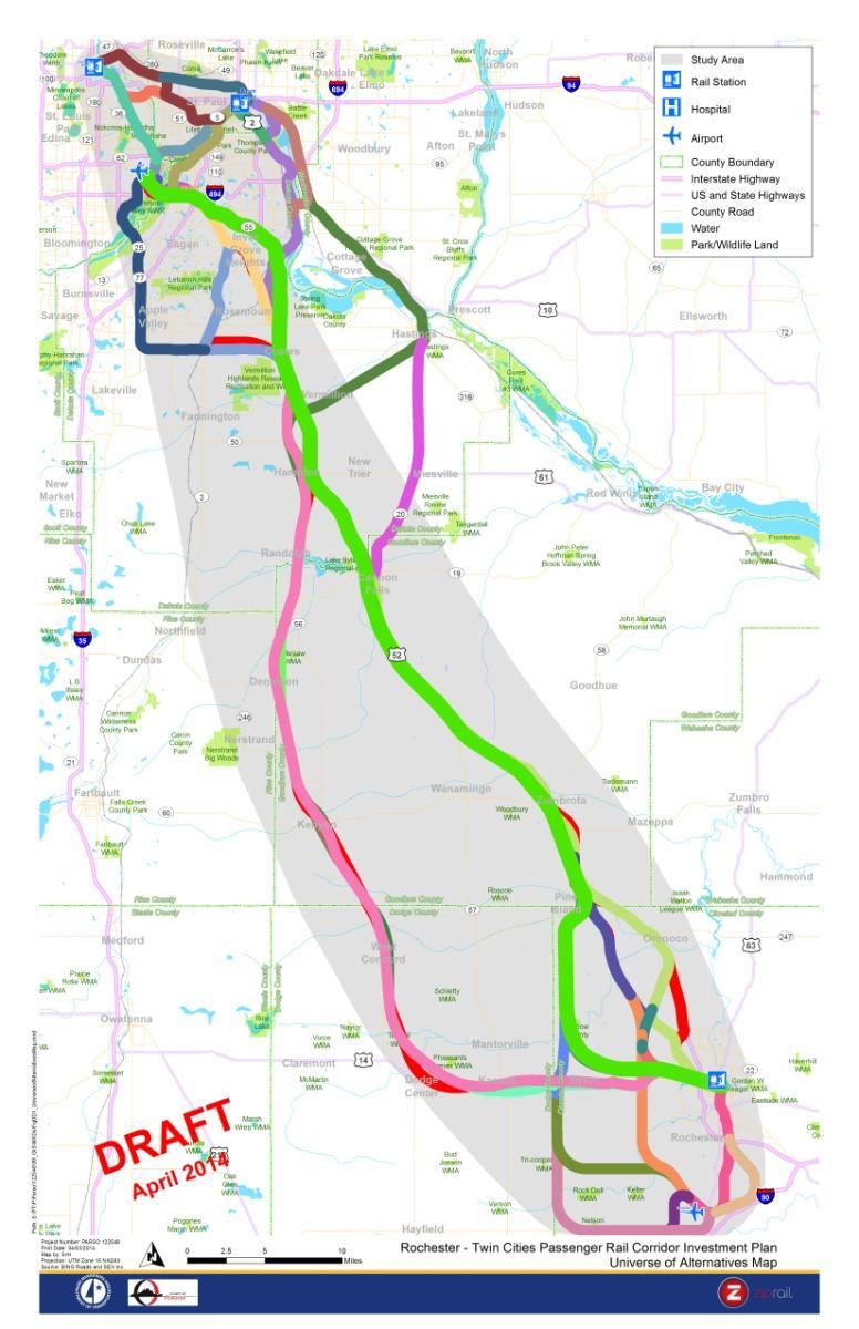
10 Universe of Alternatives Universe of Alternatives
11 Universe of Alternatives More than 1,200 possible combinations Segmented the corridor to facilitate the identification and evaluation of alignment options Northern segments between Target Field/Union Depot/MSP and Coates Southern segments between Coates and Downtown Rochester/RST Airport


12 Alternatives Development/Evaluation Evaluation Process Purpose and Need Rationale Review Level 1 Screening Level 2 Screening Tier 1 EIS We are here
13 Level 1 Screening Level 1 Screening Criteria Preliminary Travel Time (end to end) Redundancy Impacts to the Natural Environment Impacts to the Built Environment
14 Level 1 Screening Results 15 Alternatives to be carried forward Two potential routes Coates to MSP Three potential routes Coates to Union Depot Two potential routes Coates to Rochester
15 Level 2 Screening Level 2 Screening Criteria Preliminary Travel Time (end to end) Top Speed Ridership Consistency with Local Planning Efforts Connectivity Social, Economic and Environmental Impacts
16 Additional Stakeholder Input Level 2 Alternatives evaluated based on input from: Hennepin, Ramsey, Dodge, Goodhue, Olmsted and Dakota Counties Metropolitan Council FAA/Metropolitan Airports Commission Rochester-Olmsted Council of Governments (ROCOG) UMore Park/University of Minnesota Flint Hills Resources Canadian Pacific Railway Union Pacific Railroad
17 Level 2 Screening Results East Alternatives West Alternatives

18 Level 2 Screening Results Metro Area corridor alternatives to MSP and Union Depot
19 Level 2 Screening Results Key decisions to be made in the Tier 1 EIS: Primary Terminal Points Locate Mississippi and Minnesota River crossing(s) Corridor north of Coates Corridor south of Coates
20 Additional Stakeholder Input Upcoming City Coordination to be Scheduled with: Minneapolis St. Paul Bloomington Richfield Eagan Inver Grove Heights Northfield South St. Paul West St. Paul Mendota Heights Kasson Byron Cannon Falls Pine Island Zumbrota Dodge Center Kenyon Oronoco West Concord Lilydale Hampton Sunfish Lake Dennison Coates
21 Next Steps State Environmental Scoping Booklet Coordination with Cities along corridors Second Round of Public Meetings Summer 2014 Alternatives Evaluation Report Kick off Tier-1 NEPA Document
22 Project Contacts MnDOT Dan Krom: Praveena Pidaparthi: Olmsted County Regional Railroad Authority Chuck Michael: Project Web Site:
23 Rochester-Twin Cities Passenger Rail Corridor Investment Plan Metropolitan Council Transportation Committee June 9, 2014
Atlanta BeltLine Corridor Environmental Study. Scoping Meeting August 2008
 Atlanta BeltLine Corridor Environmental Study Scoping Meeting August 2008 What Will We Be Discussing Today? Study Overview - How Did We Get Here? - What Is the Study About? - Who Is Involved? - Where Is
Mississippi Skyway Preliminary Engineering Report
 EXECUTIVE SUMMARY Mississippi Skyway Preliminary Engineering Report CITY OF RAMSEY, MINNESOTA DECEMBER 2014 City of RAMSEY EXECUTIVE SUMMARY Project Need and Intent The Mississippi Skyway pedestrian bridge
1.0 INTRODUCTION 1.1 TH 14 WEST STUDY AREA Project Description Functional Classification Purpose of the Project
 1.0 INTRODUCTION 1.1 TH 14 WEST STUDY AREA 1.1.1 Project Description The Trunk Highway (TH) 14 West Corridor is a two-lane roadway approximately 22 miles in length. Located in Nicollet County, the corridor
Metropolitan Parks and Open Space Commission
 Business Item No. 2013-xxx Metropolitan Parks and Open Space Commission Meeting date: October 1, 2013 For the Community Development Committee meeting of October 7, 2013 Subject: Mendota-Lebanon Hills Greenway
Subject: City of Richfield Cedar Avenue Corridor Plan Comprehensive Plan Amendment, Review File No
 Committee Report Business Item No. 2017-21 Community Development Committee For the Metropolitan Council meeting of January 25, 2017 Subject: City of Richfield Cedar Avenue Corridor Plan Comprehensive Plan
OPEN HOUSE #3. Project Manager Kristi Sebastian, PE, PTOE
 OPEN HOUSE #3 Project Manager Kristi Sebastian, PE, PTOE kristi.sebastian@co.dakota.mn.us 952-891-7100 WHY ARE WE CONDUCTING THE ARTERIAL CONNECTOR STUDY? Dakota County and the cities of Rosemount, Inver
Hastings Area Roadway System Study. February 2009
 Hastings Area Roadway System Study February 2009 TABLE OF CONTENTS EXECUTIVE SUMMARY... iii I. INTRODUCTION & BACKGROUND... 1 A. STUDY GOAL & STUDY AREA... 1 B. NEED FOR STUDY... 1 C. AGENCY COORDINATION
Corridor Management Committee. September 29, 2017
 Corridor Management Committee September 29, 2017 1 Today s Topics Chair s Update Proposed Corridor Protection Wall Aesthetic Design Overview Public Outreach Environmental Review Civil Construction Update
Transportation Committee
 Transportation Committee Business Item No. 2013-286SW Meeting date: October 14, 2013 For the Metropolitan Council meeting of October 16, 2013 Subject: Southwest Light Rail Transit (Green Line Extension):
Place and Opportunity: An Equity Assessment of the Twin Cities Region (www.metrocouncil.org/
 1 Purpose and Need This chapter gives an overview of the proposed METRO Blue Line Light Rail Transit (BLRT) Extension project, including its location and setting within the local communities and the region,
MINNEHAHA. Hiawatha. Strategic. Framework. Community Works. Investment
 Strategic Investment Framework MINNEHAHA Hiawatha Community Works A partnership and unity between County, City, Neighborhoods and Community Project Partners Hennepin County City of Minneapolis Neighborhood
ARGENTA TRAIL (CSAH 28/63) REALIGNMENT SOUTH PROJECT (CP 63-25)
 REALIGNMENT SOUTH PROJECT (CP 63-25)") ARGENTA TRAIL (CSAH 28/63) REALIGNMENT SOUTH PROJECT (CP 63-25) Preliminary Design Report February 2015 Prepared For: City of Inver Grove Heights Dakota County Prepared By: Kimley-Horn and Associates,
ARGENTA TRAIL (CSAH 28/63) REALIGNMENT SOUTH PROJECT (CP 63-25) Preliminary Design Report February 2015 Prepared For: City of Inver Grove Heights Dakota County Prepared By: Kimley-Horn and Associates,
Illinois Planning and Environmental Studies for FRA Applications for High-Speed and Intercity Passenger Rail (HSIPR)
") Illinois Planning and Environmental Studies for FRA Applications for High-Speed and Intercity Prepared by Tim Selover, PE, AICP Parsons Brinckerhoff On April 16, 2009, President Obama described his Vision
Illinois Planning and Environmental Studies for FRA Applications for High-Speed and Intercity Prepared by Tim Selover, PE, AICP Parsons Brinckerhoff On April 16, 2009, President Obama described his Vision
West Broadway Transit Study Initial Screening of Alternatives Memo
 West Broadway Transit Study Initial Screening of Alternatives Memo 5/22/2015 Prepared by the SRF Consulting Group Team for Table of Contents Purpose... 1 Methodology... 1 Screening... 5 Screening Criteria...
2015 SYSTEM STATEMENT. System Statement Issue Date:
 2015 SYSTEM STATEMENT System Statement Issue Date: 2015 SYSTEM STATEMENT FOR HENNEPIN COUNTY September 17, 2015 Regional Development Plan Adoption In May 2014, the Metropolitan Council adopted Thrive MSP
Missing Link Study Grand Rounds Parkway Planning and Design Introduction
 Missing Link Study Grand Rounds Parkway Planning and Design Introduction June 19, 2007 Minneapolis Park and Recreation Board HNTB Hoisington Koegler Group Inc. Hess Roise 1 The Missing Link Study The Minneapolis
Updating Speed Performance Measures of Minnesota s Interregional Corridor (IRCs) System
 System") Updating Speed Performance Measures of Minnesota s Interregional Corridor (IRCs) System By Banette Kritzky, GIS Coordinator, MnDOT, Office of Investment Mgmt ESRI 2004 Background! Began identifying key
Updating Speed Performance Measures of Minnesota s Interregional Corridor (IRCs) System By Banette Kritzky, GIS Coordinator, MnDOT, Office of Investment Mgmt ESRI 2004 Background! Began identifying key
RESOLUTION NO. R Refining the route, profile and stations for the Downtown Redmond Link Extension
 RESOLUTION NO. R2018-32 Refining the route, profile and stations for the Downtown Redmond Link Extension MEETING: DATE: TYPE OF ACTION: STAFF CONTACT: Capital Committee Board PROPOSED ACTION 09/13/2018
PROJECT BACKGROUND. Preliminary Design Scope and Tasks
 PROJECT BACKGROUND Preliminary Design Scope and Tasks The purpose of this Study is the development of preliminary designs for intersection improvements for Trunk Highway (TH) 36 at the intersections of
Nine Mile Creek Regional Trail Update. Edina City Council Workshop March 4, 2014
 Nine Mile Creek Regional Trail Update Edina City Council Workshop March 4, 2014 Presentation Outline: Where we ve been - Recap of route assessment process and approved route Where we are now - Summary
2. AGENCY COORDINATION AND PUBLIC INVOLVMENT
 2. AGENCY COORDINATION AND PUBLIC INVOLVMENT This chapter discusses the process carried out for conducting agency coordination and public involvement activities. TECHNICAL ADVISORY COMMITTEE A Technical
Environmental Assessment Page Purpose and Need
 Environmental Assessment Page 1-1 1. Purpose and Need This chapter describes the location and setting of the Gateway Corridor project, the needs driving the study of the project, the purpose of the project,
Welcome! Get On Board!
 Get On Board! Welcome! Thank you for a ending! This public informa on mee ng is being held to provide an update and an opportunity to comment on DC2RVA s: Purpose and Need Statement Alterna ves Development
Corridor Management Committee. April 14, 2016
 Corridor Management Committee April 14, 2016 1 Today s Topics Chair s Update Corridor-wide Safety/Security Golden Valley Rd Park & Ride, Trails and Intersection Section 106 (Historic Properties) Update
This chapter describes the purpose of the Plan, introduces how the Plan is organized and provides contextual background for the Plan.
 Chapter 1: INTRODUCTION Purpose of a Comprehensive Plan The 2040 Comprehensive Plan establishes Medina s vision as a community and sets goals and objectives which guide future decisions and policies. The
Corridor Vision. 1Pursue Minnehaha-Hiawatha Community Works Project. Mission of Hennepin County Community Works Program
 1Pursue Minnehaha-Hiawatha Community Works Project Minnehaha-Hiawatha Community Works is a project within the Hennepin Community Works (HCW) program. The mission of the HCW program is to enhance how the
BeltLine Corridor Environmental Study
 BeltLine Corridor Environmental Study Citywide Conversation on Transit and Trails April 2, 2009 Agenda & Introductions Introductions Environmental Study Process Overview of the BeltLine Project BeltLine
I-90 Mississippi River Bridge & Interchange Project
 I-90 Mississippi River Bridge & Interchange Project Presentation Outline I. Background: Context & Need for Project II. Preferred Alternative Overview III. Project Development IV. Project Management Tools
June 14, 2017 for the June 20, 2017 Parks and Trails Commission Meeting
 105 South Fifth Avenue Suite 513 Minneapolis, MN 55401 Tel: 612-252-9070 Fax: 612-252-9077 www.landform.net TO: FROM: DATE: Corcoran Parks and Trails Commission Kendra Lindahl, Landform June 14, 2017 for
Bassett Creek Valley Working Group. October 4, 2017
 Bassett Creek Valley Working Group October 4, 2017 1 Today s Topics Introductions Overview of Design Teams (P+W and WSP) Expertise Working Group Roles and Responsibilities Schedule & Community Engagement
Orange Line Bus Rapid Transit Public Engagement Plan
 Orange Line Bus Rapid Transit Metro Transit Contents 1 Introduction 3 2 Project Plan Update decision making 6 3 Key stakeholders 8 4 Outreach techniques and tools 11 5 Reflection of public input in decision
Transportation Systems and Utility Infrastructure
 77 Audience Local and regional units of government, Landowners and developers, Community and citizen organizations, and Transportation/utility planners and engineers. Overview Transportation systems and
HIGHWAY DEPARTMENT: Planning and Programming Division: An Inventory of Its Transportation Planning Studies
 MINNESOTA HISTORICAL SOCIETY Minnesota State Archives HIGHWAY DEPARTMENT: Planning and Programming Division: An Inventory of Its Transportation Planning Studies OVERVIEW OF THE RECORDS Agency: Minnesota.
7.0 SECTION 4(F) EVALUATION
 EVALUATION") Chapter 7 Section 4(f) Evaluation 7.0 SECTION 4(F) EVALUATION 7.1 Background Information and Regulatory Requirements This chapter presents the existing conditions and potential effects to parklands and
Chapter 7 Section 4(f) Evaluation 7.0 SECTION 4(F) EVALUATION 7.1 Background Information and Regulatory Requirements This chapter presents the existing conditions and potential effects to parklands and
Concept Master Plan. for. Draft of. Wildlife Management Area. Prepared for. June, 2008
 Draft of Concept Master Plan for Vermillion Highlands: A Research, Recreation and Wildlife Management Area Prepared for Vermillion Highlands Steering Committee - Minnesota Department of Natural Resources
Southeast Extension to RidgeGate Parkway Scoping Booklet
 Southeast Extension to RidgeGate Parkway Scoping Booklet PUBLIC SCOPING MEETING SCHEDULE Public Scoping Meeting Wednesday, November 2, 2011 6:00pm to 7:30pm City of Lone Tree Recreation Center Willow Room
Southwest Light Rail Transit (LRT) A corridor of opportunity
 A corridor of opportunity") Southwest Light Rail Transit (LRT) A corridor of opportunity Minneapolis Jobs: 151,200 Suburban Jobs: 72,400 Downtown Minneapolis 147,000 emp.* West Calhoun 4,200 emp. Beltline Business Park 6,000 emp.
Southwest Light Rail Transit (LRT) A corridor of opportunity Minneapolis Jobs: 151,200 Suburban Jobs: 72,400 Downtown Minneapolis 147,000 emp.* West Calhoun 4,200 emp. Beltline Business Park 6,000 emp.
Rich Valley Greenway Master Plan. Central Greenway Connectivity Study
 Rich Valley Greenway Master Plan Central Greenway Connectivity Study Dakota County Planning Commission February, 2017 Rich Valley Greenway Master Plan Dakota County Greenway Vision Establish a County-wide
Central Corridor Light Rail Transit. Environmental Assessment Three Infill Stations. Western, Victoria, and Hamline
 Central Corridor Light Rail Transit Environmental Assessment Three Infill Stations Western, Victoria, and Hamline Metropolitan Council January 2010 ABSTRACT The Metropolitan Council on behalf of the Federal
2030 Comprehensive Plan VISION STATEMENT
 RESOURCE DOCUMENT for Steering Committee Meeting #2 July 12, 2017 2030 Comprehensive Plan VISION STATEMENT Steering Committee from 2008 Established the Lauderdale s Vision as: Creating a livable, lovable
Longmeadow Parkway Fox River Bridge Corridor. August 6, 2015
 Longmeadow Parkway Fox River Bridge Corridor August 6, 2015 Longmeadow Parkway Bridge Corridor 5.6 miles from Huntley Road to IL 62 Unique municipal/county/state/federal partnership Links Randall Road
METRO Gold Line BRT CBAC Meeting. August 23, 2018
 METRO Gold Line BRT CBAC Meeting August 23, 2018 1 Today s Topics Introductions Corridor Management Committee Update Public Engagement Update History of Alignment Project Scope Discussions Upcoming CBAC
4 Park Planning and Design
 4 Park Planning and Design Park Constellations Elliot Gateway/Mills Loring North Loop Commons Twins Minneapolis Park & Recreation Board Downtown Service Area Master Plan 4-1 PROJECT APPROACH REFERENCE
Mendota-Lebanon Hills Greenway Master Plan Executive Summary. August draft for more information visit
 Mendota-Lebanon Hills Greenway Master Plan Executive Summary August 2013 draft for more information visit www.hkgi.com/projects/dakota INTRODUCTION The Mendota-Lebanon Hills Greenway Master Plan portrays
METROPOLITAN COUNCIL 390 North Robert Street, St. Paul, MN Phone (651) ; TDD (651)
 ; TDD (651)") DATE: December 20, 2011 METROPOLITAN COUNCIL 390 North Robert Street, St. Paul, MN 55101 Phone (651) 602-1000; TDD (651) 291-0904 TO: Metropolitan Parks and Open Space Commission FROM: Tori Dupre, Senior
DATE: December 20, 2011 METROPOLITAN COUNCIL 390 North Robert Street, St. Paul, MN 55101 Phone (651) 602-1000; TDD (651) 291-0904 TO: Metropolitan Parks and Open Space Commission FROM: Tori Dupre, Senior
2030 Transit System Plan Refresh
 2030 Transit System Plan Refresh Centers and Corridors Project Connect Growth Concept Map Joint use Task Force CRTPO Technical Coordinating Committee July 6, 2017 City of Charlotte The Origin Story Centers
Land Use and Economic Development 2015 New Starts Executive Summary
 Land Use and Economic Development 2015 New Starts Executive Summary TRANSIT-SUPPORTIVE POLICIES St. Louis Park Minneapolis GROWTH MANAGEMENT STATION AREA PLANNING Hopkins REGIONAL JOB CENTERS TRANSIT-ORIENTED
Primary Contact. Organization Information. Application Multiuse Trails and Bicycle Facilities
 Application 01971-2014 Multiuse Trails and Bicycle Facilities 02195 - Regional Trail from Lebannon Hills to Downtown Regional Solicitation - Bicycle and Pedestrian Facilities Status: Submitted Date: Submitted
DRAFT Subject to modifications
 TREASURE COAST REGIONAL PLANNING COUNCIL DRAFT M E M O R A N D U M To: Council Members AGENDA ITEM 7C From: Date: Subject: Staff September 17, 2010 Council Meeting Commuter Rail Update Resolution of Support
METROPOLITAN COUNCIL 390 North Robert Street, St. Paul, MN Phone (651) ; TDD (651)
 ; TDD (651)") DATE: October 24, 2012 METROPOLITAN COUNCIL 390 North Robert Street, St. Paul, MN 55101 Phone (651) 602-1000; TDD (651) 291-0904 TO: Metropolitan Parks and Open Space Commission FROM: Tori Dupre, Senior
DATE: October 24, 2012 METROPOLITAN COUNCIL 390 North Robert Street, St. Paul, MN 55101 Phone (651) 602-1000; TDD (651) 291-0904 TO: Metropolitan Parks and Open Space Commission FROM: Tori Dupre, Senior
Seattle Transit Master Plan
 Seattle Transit Master Plan Seattle City Council Transportation Committee Briefing May 10, 2011 Seattle Department of Transportation Presentation Outline Review of project schedule and goals Review of
MINNESOTA ARCHITECTURE - HISTORY INVENTORY FORM
 Identification Historic Name Dean Parkway Bridge Current Name Bridge 90661 Field # Address Midtown Greenway over Dean Parkway City/Twp Minneapolis County Hennepin Legal Desc. Twp 29N Range 24W Sec 32 QQ
RED ROCK CORRIDOR STATION AREA PLANNING
 STATION AREA PLANNING FINAL REPORT for the 4 proposed commuter rail stations along the southeast portion of the Red Rock Corridor: ST. PAUL (Lower Afton) NEWPORT COTTAGE GROVE (Langdon Village) HASTINGS
Property Description History Regional Orientation Local Context Existing Assets Analysis Of Developable Areas...
 Appendix: Site Background and Analysis Property Description.... 48 History.... 48 Regional Orientation... 49 Local Context... 52 Existing Assets... 53 Analysis Of Developable Areas... 64 Aggregate Resources....
Congestion Management Safety Plan. Michael Corbett State Program Administrator September 2017
 Congestion Management Safety Plan Michael Corbett State Program Administrator September 2017 Agenda Topic 1 What is the Congestion Management Safety Plan (CMSP)? 2 Relevance to Congestion Investments 3
Mendota/Lebanon Hills Greenway. Master Plan
 Mendota/Lebanon Hills Greenway Master Plan Preliminary DRAFT chapters 1 & 2-27 Feb 2013 Mendota/Lebanon Hills Greenway DRAFT Master Plan Acknowledgements Dakota County Board of Commissioners District 1
Tracking the Blue Line Extension
 BROOKLYN PARK CRYSTAL ROBBINSDALE GOLDEN VALLEY MINNEAPOLIS Tracking the Blue Line Extension Issue 11 April 2018 Goals to finish designs, apply for federal funds in 2018 Rendering of the 63rd Avenue Station
CITY OF CHARLOTTESVILLE, VIRGINIA CITY COUNCIL AGENDA
 CITY OF CHARLOTTESVILLE, VIRGINIA CITY COUNCIL AGENDA Agenda Date: December 16, 2013 Action Required: Adoption of Resolution Presenter: Staff Contacts: Title: James E. Tolbert, AICP, Director of NDS James
SUMMARY. Support the Southeast Arkansas Regional Intermodal Facility.
 SUMMARY THE I-69 LOCATION STUDY The proposed I-69 Location Study from El Dorado to McGehee, Arkansas, represents one section (Section of Independent Utility No. 13) of the nationally designated I-69 Corridor
Western Light Rail Transit Corridor Planning and Environmental Assessment Study. Public Open House #2 25 April 2013
 Western Light Rail Transit Corridor Planning and Environmental Assessment Study Public Open House #2 25 April 2013 1 Presentation Overview 2 1. Where We Began Background and Study Area 2. Understanding
Regional Transportation District
 NORTHEAST AREA TRANSIT EVALUATION FINAL REPORT Prepared for: Regional Transportation District Prepared by: David Evans and Associates, Inc. URS, Corporation November 2007 LIST OF FIGURES Figure 1: Northeast
VISUALIZATION TOOLS FOR COMMUNICATION & DECISION MAKING REAL MINNESOTA EXAMPLES
 REAL MINNESOTA EXAMPLES 23rd Annual CTS Transportation Research Conference Leif Garnass, P.E., PTOE Senior Engineer lgarnass@srfconsulting.com Sean Jergens, ASLA, LEED AP Senior Landscape Architect sjergens@srfconsulting.com
1.0 Circulation Element
 5/9/18 1.0 Circulation Element 1.1 Introduction As growth and development occur in Apache County, enhancements to its circulation system will be necessary. With time, more roads will be paved and air and
Albert Lea. Redevelopment Plan. 701 Xenia Avenue South, Suite 300 Minneapolis, MN Tel: (763) Fax: (763) wsbeng.
 Fax: (763) wsbeng.") Albert Lea Redevelopment Plan 701 Xenia Avenue South, Suite 300 Minneapolis, MN 55416 Tel: (763) 541-4800 Fax: (763) 541-1700 wsbeng.com Albert Lea Redevelopment Plan Table of Contents Composite Districts...
Albert Lea Redevelopment Plan 701 Xenia Avenue South, Suite 300 Minneapolis, MN 55416 Tel: (763) 541-4800 Fax: (763) 541-1700 wsbeng.com Albert Lea Redevelopment Plan Table of Contents Composite Districts...
Mendota Heights 2040 Comprehensive Plan Draft Vers
 4 Parks and Trails The City of Mendota Heights boasts a variety of recreational and open space opportunities. Few cities can claim access to regional trails, riverside and lakeside parks, scenic bluffs
Iowa 100 Extension Project Visualizations for Design and Public Involvement ASCE Transportation Conference November 6, 2013 Ames, Iowa
 Iowa 100 Extension Project Visualizations for Design and Public Involvement 2013 ASCE Transportation Conference November 6, 2013 Ames, Iowa Agenda Project Corridor Constraints Key Features Project History
Corridor Background. Defining the Corridor Study Area. Lake Street. 38th Street. 46th Street
 1 Corridor Background Defining the Corridor Study Area Minnehaha Avenue (CSAH 48) and Hiawatha Avenue (MN 55) are parallel diagonal roadways, approximately three blocks apart, that provide two direct arterial
OFFICIAL CONTROLS IMPLEMENTATION LEGAL REQUIREMENTS
 IMPLEMENTATION The objective of the Implementation component of the Comprehensive Plan is to identify the changes that need to be made to the official controls in order to be consistent with the Comprehensive
Project Management Plan
 South Suburban Commuter Rail Corridor: Land Use and Local Financing Study March 13, 2003 v 3.0 03/03 Introduction The southeast portion of Cook County, Illinois comprising the majority of the South Suburban
I-84 Hartford Project Open Planning Studio #12. April 25, 2017
 I-84 Hartford Project Open Planning Studio #12 April 25, 2017 Meeting Agenda 1. I-84 Hartford Project alternatives update 2. Multimodal station area planning 3. I-84 / I-91 Interchange Study coordination
Kick-off Meeting. FM No: ETDM No: 14050
 Kick-off Meeting FM No: 433511-1-22-01 ETDM No: 14050 June 26, 2014 FM No. 433511 1 22 01 Project Location 2 Project Purpose and Need Improve traffic operations and safety conditions at the intersections
Robbinsdale LRT Station. CDI Development Guidelines. August Overview
 Robbinsdale LRT Station August 2018 Overview The City of Robbinsdale may have the coolest opportunity site along the 13 mile stretch of the Bottineau LRT corridor / Blue Line extension. Located a block
MISSISSIPPI GORGE REGIONAL PARK MASTER PLAN
 MISSISSIPPI GORGE REGIONAL PARK MASTER PLAN Minneapolis Park and Recreation Board CAC MEETING #1 APRIL 23, 2018 AGENDA Mississippi Gorge Regional Park Master Plan CAC #1 01 / Welcome and Calling Circle
Ann Arbor Intermodal Station Environmental Review
 Ann Arbor Intermodal Station Environmental Review Park Advisory Commission September 19, 2017 AGENDA 1. Project Update 2. Draft Environmental Assessment 3. Draft Preferred Alternative 4. Next Steps 5.
CHAIR AND MEMBERS CIVIC WORKS COMMITTEE MEETING ON JULY 17, 2017
 TO: FROM: CHAIR AND MEMBERS CIVIC WORKS COMMITTEE MEETING ON JULY 17, 2017 KELLY SCHERR, P.ENG., MBA, FEC MANAGING DIRECTOR, ENVIRONMENTAL & ENGINEERING SERVICES AND CITY ENGINEER SUBJECT: HIGH SPEED RAIL
MINNESOTA HISTORIC PROPERTY RECORD PART I. PROPERTY IDENTIFICATION AND GENERAL INFORMATION
 MINNESOTA HISTORIC PROPERTY RECORD PART I. PROPERTY IDENTIFICATION AND GENERAL INFORMATION Common Name: Fort Snelling-Mendota Bridge Bridge Number: 4190 Identification Number: Location: Feature Carried:
12/9/2013. HOLLYWOOD/PINES CORRIDOR PROJECT AMPO 2013 Annual Conference October 24, Our Perspective. Broward.
 HOLLYWOOD/PINES CORRIDOR PROJECT AMPO 2013 Annual Conference October 24, 2013 Our Perspective Broward Fort Lauderdale 1 Broward Metropolitan Planning Organization Fort Lauderdale Fort Lauderdale Skyline
Regional Sustainability: Planning, Implementation, and Measurement
 Regional Sustainability: Planning, Implementation, and Measurement Carissa Schively Slotterback, PhD, AICP Humphrey School of Public Affairs, University of Minnesota ULI Minnesota Lightening Our Footprint
Route 110 Alternatives Analysis
 Route 110 Alternatives Analysis Public Meeting #1 December 15, 2014 Source: Town of Babylon Agenda Welcome/Introduction Hon. Antonio A. Martinez Deputy Supervisor, Town of Babylon Update on East Farmingdale
NASSAU COUNTY TOWN HALL NEW YORK & CONNECTICUT SUSTAINABLE COMMUNITIES. A Unique Bi-State Partnership to Improve Jobs, Housing and Transportation
 NASSAU COUNTY TOWN HALL NEW YORK & CONNECTICUT SUSTAINABLE COMMUNITIES A Unique Bi-State Partnership to Improve Jobs, Housing and Transportation Police Headquarters Auditorium Mineola, NY December 9 th,
WELCOME TO THE CHOUTEAU GREENWAY DESIGN, DEVELOPMENT AND CONSTRUCTION WORKING GROUP!
 WELCOME TO THE CHOUTEAU GREENWAY DESIGN, DEVELOPMENT AND CONSTRUCTION WORKING GROUP! Chouteau Greenway Steering Committee and Working Groups Overview Overview January 9, 2019 Chouteau Greenway will transform
ROBBINSDALE LRT STATION CDI DEVELOPMENT GUIDELINES
 August 2018 OVERVIEW The City of Robbinsdale has a prime-opportunity site in the middle of the 13 mile stretch of the Bottineau LRT corridor / Blue Line extension. Robbinsdale offers a prominent, vital,
GOVERNOR S RECOMMENDATIONS (BY AGENCY & SCORES) STATE OF MINNESOTA. Agency Request. Administration, Department of. Amateur Sports Commission
 STATE OF MINNESOTA. Agency Request. Administration, Department of. Amateur Sports Commission") Administration, Department of Continue Capitol Restoration 6, State Office Building Restoration Design 7, 6,, Relocation, Capitol Complex Monuments/Memorials Repairs and Restoration, Statewide CAPRA,,,
Administration, Department of Continue Capitol Restoration 6, State Office Building Restoration Design 7, 6,, Relocation, Capitol Complex Monuments/Memorials Repairs and Restoration, Statewide CAPRA,,,
Chesterfield County Project Update
 Chesterfield County Project Update SOUTHEAST HIGH SPEED RAIL TIER II ENVIRONMENTAL IMPACT STATEMENT RICHMOND, VA, TO RALEIGH, NC CHESTERFIELD COUNTY, VA OFFICIALS BRIEFING February 2013 Federal Railroad
Relief Line Project Assessment
 6/9/2015 Relief Line Project Assessment Stakeholder Advisory Meeting #2 June 9, 2015 Meeting Purpose Report on the Evaluation Results for Potential Station Locations Seek your Input on Potential Corridors
Rosemount Greenway Master Plan Executive Summary. draft. Spring for more information visit
 Rosemount Greenway Master Plan Executive Summary Spring 2012 draft for more information visit www.hkgi.com/projects/dakota INTRODUCTION The Rosemount Greenway Master Plan portrays a vision to establish
PREPARED FOR: PLATTEVIEW ROAD CORRIDOR STUDY EXECUTIVE SUMMARY
 PREPARED FOR: PLATTEVIEW ROAD CORRIDOR STUDY EXECUTIVE SUMMARY SEPTEMBER 2016 Introduction The Platteview Road Corridor Study was led by the Metropolitan Area Planning Agency (MAPA) with assistance from
CITY COUNCIL AGENDA REPORT
 CITY COUNCIL AGENDA REPORT Subject: COUNCIL MOTION LRT ALIGNMENT REMOVAL FROM THE TRANSPORTATION MASTER PLAN On February 10, 2016 Councillor Hughes provided notice in accordance with Section 23 of Procedure
METRO Gold Line BRT CMC Meeting
 METRO Gold Line BRT CMC Meeting April 26, 2018 Today s Topics Welcome and Introductions Project Overview CMC Roles and Responsibilities Current Project Baseline: Scope and Cost Estimate Overview Municipal
7.0 DRAFT SECTION 4(f) EVALUATION
 EVALUATION") 7. DRAFT SECTION 4(f) EVALUATION 7.1 Background Information and Regulatory Requirements This chapter presents the existing conditions and potential effects on parks, recreation areas, wildlife and waterfowl
7. DRAFT SECTION 4(f) EVALUATION 7.1 Background Information and Regulatory Requirements This chapter presents the existing conditions and potential effects on parks, recreation areas, wildlife and waterfowl
Phase I Results. Minnesota Local Historic Bridge Study. Minnesota Department of Transportation. Bridge 448 in Olmsted County. Report prepared for
 Phase I Results Minnesota Local Historic Bridge Study Bridge 448 in Olmsted County Report prepared for Minnesota Department of Transportation Bridge L7075 in Todd County Report prepared by www.meadhunt.com
A PROPOSAL FOR THE Small Area Corridor Plan
 A PROPOSAL FOR THE Small Area Corridor Plan for the City of Alexandria 17th/18th Avenue and TH29/Nokomis Street Corridor 701 Xenia Avenue South Suite 300 Minneapolis, MN 55416 (763) 541-4800 January 31,
Minnesota River Greenway, Eagan Segment
 Minnesota River Greenway, Eagan Segment Feasibility Study Report Final July 2014 TABLE OF CONTENTS TABLE OF CONTENTS... i EXECUTIVE SUMMARY... iv I. INTRODUCTION... 1 A. Dakota County Greenway Vision...
Figure 5. Previously Identified Viable Corridors
 OVERVIEW The Central Florida Expressway Authority (CFX) is evaluating the potential to expand SR 408 from its current eastern terminus along SR 50 to SR 520 in northeastern Orange County, Fl. This new
Infrastructure Engineering Planning Construction Suite 300 Minneapolis, MN Tel: Fax:
 Infrastructure Engineering Planning Construction 701 Xenia Avenue outh uite 300 Minneapolis, MN 55416 Tel: 763-541-4800 Fax: 763-541-1700 Memorandum To: Minnehaha Creek Watershed District Board From: Tony
Stakeholder Presentation
 CORE Connections 2035 LRTP Stakeholder Presentation Developed for CORE MPO Presented by: Marlene Connor Wilbur Smith Associates March 4, 2010 1 Project Setting How this study fits into other regional and
Coordinated Transit Planning in Toronto SmartTrack GO RER Scarborough Relief Line Waterfront Transit
 Coordinated Transit Planning in Toronto SmartTrack GO RER Scarborough Relief Line Waterfront Transit Public Information Centres February 2016 Transportation Planning Section City Planning Division Toronto
Business Item No
 Community Development Committee For the Community Development Committee meeting of December 19, 2016 For the Metropolitan Council meeting of January 11, 2017 Business Item No. 2016-255 Subject: River to
Promoting Economic Development Through Upfront SEPA Review: Lessons from South Downtown Tacoma
 Promoting Economic Development Through Upfront SEPA Review: Lessons from South Downtown Tacoma 1 This session will focus on the City of Tacoma s South Downtown Subarea Plan and associated Non-Project SEPA
Mendota Heights 2040 Comprehensive Plan April 2019
 4 Parks and Trails The City of Mendota Heights boasts a variety of recreational and open space opportunities, including access to regional trails, riverside and lakeside parks, scenic bluffs and a nature