VISUALIZATION TOOLS FOR COMMUNICATION & DECISION MAKING REAL MINNESOTA EXAMPLES
|
|
|
- Erik Jackson
- 5 years ago
- Views:
Transcription


1 REAL MINNESOTA EXAMPLES 23rd Annual CTS Transportation Research Conference Leif Garnass, P.E., PTOE Senior Engineer Sean Jergens, ASLA, LEED AP Senior Landscape Architect MAY 23, 2012
2 Visualization is the visual representation of proposed project alternatives and improvements and their associated impacts on the surroundings. - NCHRP 361 PRESENTATION OUTLINE Types of visualization tools Real Minnesota Examples - Graphic methodology - Benefit to project - Approximate level of effort Potential applications
3 WHY USE THESE VISUALIZATION TOOLS? Enables stakeholders and the public to understand transportation concepts and proposed solutions Allows complex information to be simplified Can highlight or reveal hidden infrastructure that is not easily portrayed in traditional graphic methods Technology is rapidly making it more efficient to create powerful visualization graphics A picture is worth a thousand words! An animation is worth millions!


4


5 ANALYSIS, DIAGRAMS, AND SECTIONS TRANSPORTATION INFRASTRUCTURE STREETSCAPE PLANNING AND DESIGN BEFORE AND AFTER PHOTO ILLUSTRATIVE PERSPECTIVES TRAFFIC SIMULATION

6 ANALYSIS, DIAGRAMS, AND SECTIONS TRANSPORTATION INFRASTRUCTURE STREETSCAPE PLANNING AND DESIGN BEFORE AND AFTER PHOTO ILLUSTRATIVE PERSPECTIVES TRAFFIC SIMULATION

7 CEDAR RIVERSIDE STREET SECTION Minneapolis, MN

8 MANUAL FOR STREET TREE & BOULEVARD DESIGN Minneapolis, MN


9 MIXED USE ZONING Moorhead, MN
10 ANALYSIS, DIAGRAMS, AND SECTIONS TRANSPORTATION INFRASTRUCTURE STREETSCAPE PLANNING AND DESIGN BEFORE AND AFTER ILLUSTRATIVE PERSPECTIVES TRAFFIC SIMULATION

11 BELTLINE BOULEVARD & WOODDALE AVENUE STATION AREA STUDIES St. Louis Park, MN


12 CENTRAL AVENUE PEDESTRIAN BRIDGE Columbia Heights, MN


13 CENTRAL AVENUE PEDESTRIAN BRIDGE Columbia Heights, MN


14 ROBERT STREET PEDESTRIAN BRIDGE FEASIBILITY West St. Paul, MN

15 ROBERT STREET PEDESTRIAN BRIDGE FEASIBILITY West St. Paul, MN

16 TH101 FLYOVER Rogers, MN


17 TH 41 RIVER CROSSING PHOTO VISUALIZATION STUDY Chaska, MN

18 TH 41 RIVER CROSSING PHOTO VISUALIZATION STUDY Chaska, MN

19 LAFAYETTE BRIDGE St. Paul, MN


20 LAFAYETTE BRIDGE St. Paul, MN


21 TH 610/ZACHARY LANE BIRD S EYE GRAPHIC Maple Grove, MN


22 DRESBACH INTERCHANGE I-90 Crossing over the Mississippi River MnDOT & WisDOT


23 DRESBACH INTERCHANGE I-90 Crossing over the Mississippi River MnDOT & WisDOT

24 ANALYSIS, DIAGRAMS, AND SECTIONS TRANSPORTATION INFRASTRUCTURE STREETSCAPE PLANNING AND DESIGN BEFORE AND AFTER ILLUSTRATIVE PERSPECTIVES TRAFFIC SIMULATION

25 BRAINERD DOWNTOWN STREETSCAPE Brainerd, MN


26 13TH STREET PEDESTRIAN IMPROVEMENTS Minneapolis, MN

27 ARTERIAL RAPID BUS TRANSIT Metropolitan Council

28 BROADWAY AVENUE Forest Lake, MN

29 ANALYSIS, DIAGRAMS, AND SECTIONS TRANSPORTATION INFRASTRUCTURE STREETSCAPE PLANNING AND DESIGN BEFORE AND AFTER PHOTO ILLUSTRATIVE PERSPECTIVES TRAFFIC SIMULATION

30 BROADWAY AVENUE Forest Lake, MN BEFORE

31 BROADWAY AVENUE Forest Lake, MN AFTER


32 84TH ST. CORRIDOR Bloomington, MN BEFORE AFTER

33 84TH ST. CORRIDOR Bloomington, MN AFTER

34 CSAH 9 Chisago County BEFORE

35 CSAH 9 Chisago County AFTER
36 ANALYSIS, DIAGRAMS, AND SECTIONS TRANSPORTATION INFRASTRUCTURE STREETSCAPE PLANNING AND DESIGN BEFORE AND AFTER PHOTO ILLUSTRATIVE PERSPECTIVES TRAFFIC SIMULATION

37 SHINGLE CREEK LAND USE STUDY Brooklyn Center, MN

38 SHINGLE CREEK LAND USE STUDY Brooklyn Center, MN

39 63RD AVENUE/ BOTTINEAU BOULEVARD LAND USE & TOD PLAN Hennepin County

40 DRESBACH INTERCHANGE I-90 Crossing over the Mississippi River MnDOT & WisDOT

41 DRESBACH INTERCHANGE I-90 Crossing over the Mississippi River MnDOT & WisDOT

42 FARGO-MOORHEAD AREA DIVERSION RECREATION AND USE MASTER PLAN

43 FARGO-MOORHEAD AREA DIVERSION RECREATION AND USE MASTER PLAN

44 ANALYSIS, DIAGRAMS, AND SECTIONS TRANSPORTATION INFRASTRUCTURE STREETSCAPE PLANNING AND DESIGN BEFORE AND AFTER PHOTO ILLUSTRATIVE PERSPECTIVES TRAFFIC SIMULATION

45 TH 610/ ZACHARY LANE Maple Grove, MN

46 LAKE ST./ SUPERIOR BLVD. Wayzata, MN
47 CSAH 2 (BROADWAY AVE.) Forest Lake, MN
48 POTENTIAL APPLICATIONS Project management meetings During the design process City council meetings County board meetings Public open houses Project newsletters, project website YouTube channel
49 REAL MINNESOTA EXAMPLES THANK YOU! Leif Garnass, P.E., PTOE Senior Engineer Sean Jergens, ASLA, LEED AP Senior Landscape Architect MAY 23, 2012
WHAT IS THE PURPOSE OF THE OPEN HOUSE?
 WHAT IS THE PURPOSE OF THE OPEN HOUSE? OPEN HOUSE PURPOSE The purpose of the open house is to provide an update on the study process and introduce the preliminary concept alternatives. The open house provides
Grand Rounds History
 Grand Rounds History 1883 Plan for Minneapolis Park System prepared by Landscape Architect Horace W. S. Cleveland. The system of connecting parks and parkways was first called the Grand Rounds by William
Blue Line LRT Extension
 v e Noble Pkwy Noble Pkwy Xerxes Ave N Shingle Creek Penn Ave N Penn Ave N Fremont Ave N Lyndale Ave N S Washington Ave University Ave NE Blue Line LRT Extension LIGHT RAIL PLATFORM AND STATION DESIGN
Corridor Vision. 1Pursue Minnehaha-Hiawatha Community Works Project. Mission of Hennepin County Community Works Program
 1Pursue Minnehaha-Hiawatha Community Works Project Minnehaha-Hiawatha Community Works is a project within the Hennepin Community Works (HCW) program. The mission of the HCW program is to enhance how the
Mississippi Skyway Preliminary Engineering Report
 EXECUTIVE SUMMARY Mississippi Skyway Preliminary Engineering Report CITY OF RAMSEY, MINNESOTA DECEMBER 2014 City of RAMSEY EXECUTIVE SUMMARY Project Need and Intent The Mississippi Skyway pedestrian bridge
I-494 Rehabilitation Project SP (I-394 to Fish Lake Interchange) June 2014 Section 4(f) De Minimis Determination
 June 2014 Section 4(f) De Minimis Determination") I-494 Rehabilitation Project SP 2785-330 (I-394 to Fish Lake Interchange) June 2014 Section 4(f) De Minimis Determination State Project Number 2785-330 Federal Project No. NHPP-I494 (002) Trunk Highway:
I-494 Rehabilitation Project SP 2785-330 (I-394 to Fish Lake Interchange) June 2014 Section 4(f) De Minimis Determination State Project Number 2785-330 Federal Project No. NHPP-I494 (002) Trunk Highway:
A PROPOSAL FOR THE Small Area Corridor Plan
 A PROPOSAL FOR THE Small Area Corridor Plan for the City of Alexandria 17th/18th Avenue and TH29/Nokomis Street Corridor 701 Xenia Avenue South Suite 300 Minneapolis, MN 55416 (763) 541-4800 January 31,
Missing Link Study Grand Rounds Parkway Planning and Design Introduction
 Missing Link Study Grand Rounds Parkway Planning and Design Introduction June 19, 2007 Minneapolis Park and Recreation Board HNTB Hoisington Koegler Group Inc. Hess Roise 1 The Missing Link Study The Minneapolis
Bassett Creek Valley Working Group. October 4, 2017
 Bassett Creek Valley Working Group October 4, 2017 1 Today s Topics Introductions Overview of Design Teams (P+W and WSP) Expertise Working Group Roles and Responsibilities Schedule & Community Engagement
Long Lost Allies? Walking Advocates & Business District Organizations. Matt Kazinka Lake Street Council. Shaina Brassard Seward Redesign
 Long Lost Allies? Walking Advocates & Business District Organizations Shaina Brassard Seward Redesign Rob Hanson West Broadway Business and Area Coalition Matt Kazinka Lake Street Council Jamie Schumacher
St. Louis Park Wooddale LRT Station Site development guidelines
 St. Louis Park Wooddale LRT Station Site development guidelines November 2013 OVERVIEW St. Louis Park s convenient location as a neighbor to Minneapolis means you re only minutes away from some of the
Welcome. Northern Segment of Hwy 100 I-90 to South of Madison Street Meeting Goals:
 Welcome Northern Segment of Hwy 100 I-90 to South of Madison Street Meeting Goals: - Review Environmental Assessment - Share Preferred Alternative -Receive Public Comments 2003 EA Preferred Alternative
Infrastructure Engineering Planning Construction Suite 300 Minneapolis, MN Tel: Fax:
 Infrastructure Engineering Planning Construction 701 Xenia Avenue outh uite 300 Minneapolis, MN 55416 Tel: 763-541-4800 Fax: 763-541-1700 Memorandum To: Minnehaha Creek Watershed District Board From: Tony
Midtown Greenway to lake street
 Making the connection: Midtown Greenway to lake street May 2016 Design experiment: site amenities, wayfinding, and activities at Cepro, near the Midtown Global Market Recent Greenway Development Highlights
Highway 100 / The Grandview Green Feasibility Study
 Highway 100 / The Grandview Green Feasibility Study Request for Funding Support January 26, 2016 Executive Summary The City of Edina requests support to investigate the feasibility of constructing a public
SELMON GREENWAY FEASIBILITY STUDY. For: Hillsborough County Metropolitan Planning Organization By: Renaissance Planning
 SELMON GREENWAY FEASIBILITY STUDY For: Hillsborough County Metropolitan Planning Organization By: Renaissance Planning SELMON GREENWAY FEASIBILITY STUDY VISION Multimodal connection between Bayshore Blvd
Transportation Committee
 Transportation Committee Business Item No. 2013-286SW Meeting date: October 14, 2013 For the Metropolitan Council meeting of October 16, 2013 Subject: Southwest Light Rail Transit (Green Line Extension):
Corridor Background. Defining the Corridor Study Area. Lake Street. 38th Street. 46th Street
 1 Corridor Background Defining the Corridor Study Area Minnehaha Avenue (CSAH 48) and Hiawatha Avenue (MN 55) are parallel diagonal roadways, approximately three blocks apart, that provide two direct arterial
Community Engagement Committee Meeting #1 December 10, :30pm-8:30pm
 Community Engagement Committee Meeting #1 December 10, 2014 6:30pm-8:30pm Welcome and Introductions Dana Murdoch Minneapolis Park and Recreation Board Project Manager Ryan French Walker Art Center Director
OPEN HOUSE #3. Project Manager Kristi Sebastian, PE, PTOE
 OPEN HOUSE #3 Project Manager Kristi Sebastian, PE, PTOE kristi.sebastian@co.dakota.mn.us 952-891-7100 WHY ARE WE CONDUCTING THE ARTERIAL CONNECTOR STUDY? Dakota County and the cities of Rosemount, Inver
#27. Timing: Short term. Costs: $$
 Land Use & Physical Resources PROJECT #27 Mobility S t u d y a n d i m p l e m e n t H i a w a t h a A v e n u e / M N 5 5 traffic signal improvements Environment & Natural Resources Economic Development
the west loop HOME TO 5,000 NEW DOGS
 the west loop the west loop HOME TO 5,000 NEW DOGS the west loop HOME TO 5,000 NEW DOGS AND 20,000 NEW RESIDENTS outline: the west loop now the vision how do we get there? opportunity LEVERAGE TRANSIT
Dayton Transportation Plan 2016 Update
 WENCK File #3164-30 February 9, 2016 Dayton Transportation Plan 2016 Update Prepared for: City of Dayton, MN 12260 S. Diamond Lake Road Dayton, MN 55327 Prepared by: WENCK Associates, Inc. 1800 Pioneer
MAY 2012 CITY OF ST. LOUIS PARK, MINNESOTA SAINT LOUIS PARK BELTLINE AREA FRAMEWORK & DESIGN GUIDELINES
 30YEARS SAIN LOUIS PARK BELLINE AREA FRAMEWORK & DESIGN GUIDELINES CIY OF S. LOUIS PARK, MINNESOA MAY 2012 ACKNOWLEDGEMENS MAYOR AND CIY COUNCIL: FOR FURHER INFORMAION CONAC: BELLINE ADVISORY COMMIEE:
Place and Opportunity: An Equity Assessment of the Twin Cities Region (www.metrocouncil.org/
 1 Purpose and Need This chapter gives an overview of the proposed METRO Blue Line Light Rail Transit (BLRT) Extension project, including its location and setting within the local communities and the region,
Embrace Green Urban Space:
 1 Embrace Green Urban Space: Parks/Green Space as Vital to Urban Livability Jenna Fletcher The Trust for Public Land LUAC November 15, 2012 2 The Trust for Public Land conserves land for people to enjoy
Corridor Management Committee. September 29, 2017
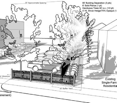
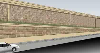
 Corridor Management Committee September 29, 2017 1 Today s Topics Chair s Update Proposed Corridor Protection Wall Aesthetic Design Overview Public Outreach Environmental Review Civil Construction Update
Proposal for Brainerd Housing and Redevelopment Authority (HRA) Mississippi River Partnership Plan Implementation. September 30, 2015
 Mississippi River Partnership Plan Implementation. September 30, 2015") Proposal for Brainerd Housing and Redevelopment Authority (HRA) Mississippi River Partnership Plan Implementation September 30, 2015 Submitted by: Bolton & Menk, Inc. 7656 Design Road Suite 200 Baxter,
Proposal for Brainerd Housing and Redevelopment Authority (HRA) Mississippi River Partnership Plan Implementation September 30, 2015 Submitted by: Bolton & Menk, Inc. 7656 Design Road Suite 200 Baxter,
4 Park Planning and Design
 4 Park Planning and Design Park Constellations Elliot Gateway/Mills Loring North Loop Commons Twins Minneapolis Park & Recreation Board Downtown Service Area Master Plan 4-1 PROJECT APPROACH REFERENCE
STREETSCAPE MANUAL ONLINE TRAINING SESSION 1: Background
 TRAINING SESSION 1: The Urban Design Streetscape Manual is a reference tool developed to help implement City policy and guide the design, construction and maintenance of streetscape improvements in Toronto.
Tracking the Blue Line Extension
 BROOKLYN PARK CRYSTAL ROBBINSDALE GOLDEN VALLEY MINNEAPOLIS Tracking the Blue Line Extension Issue 11 April 2018 Goals to finish designs, apply for federal funds in 2018 Rendering of the 63rd Avenue Station
Albert Lea. Redevelopment Plan. 701 Xenia Avenue South, Suite 300 Minneapolis, MN Tel: (763) Fax: (763) wsbeng.
 Fax: (763) wsbeng.") Albert Lea Redevelopment Plan 701 Xenia Avenue South, Suite 300 Minneapolis, MN 55416 Tel: (763) 541-4800 Fax: (763) 541-1700 wsbeng.com Albert Lea Redevelopment Plan Table of Contents Composite Districts...
Albert Lea Redevelopment Plan 701 Xenia Avenue South, Suite 300 Minneapolis, MN 55416 Tel: (763) 541-4800 Fax: (763) 541-1700 wsbeng.com Albert Lea Redevelopment Plan Table of Contents Composite Districts...
ROBBINSDALE LRT STATION CDI DEVELOPMENT GUIDELINES
 August 2018 OVERVIEW The City of Robbinsdale has a prime-opportunity site in the middle of the 13 mile stretch of the Bottineau LRT corridor / Blue Line extension. Robbinsdale offers a prominent, vital,
Designing Walkable Urban Thoroughfares: A Context Sensitive Approach
 Designing Walkable Urban Thoroughfares: A Context Sensitive Approach Communities Want: Flexibility Compatibility with adjacent land uses Balanced land use/transportation functions Safe and attractive streets
7.0 SECTION 4(F) EVALUATION
 EVALUATION") Chapter 7 Section 4(f) Evaluation 7.0 SECTION 4(F) EVALUATION 7.1 Background Information and Regulatory Requirements This chapter presents the existing conditions and potential effects to parklands and
Chapter 7 Section 4(f) Evaluation 7.0 SECTION 4(F) EVALUATION 7.1 Background Information and Regulatory Requirements This chapter presents the existing conditions and potential effects to parklands and
METRO Gold Line BRT CBAC Meeting. August 23, 2018
 METRO Gold Line BRT CBAC Meeting August 23, 2018 1 Today s Topics Introductions Corridor Management Committee Update Public Engagement Update History of Alignment Project Scope Discussions Upcoming CBAC
Gratigny Parkway East Extension Project Development & Environment (PD&E) Study
 Study") Gratigny Parkway East Extension Project Development & Environment (PD&E) Study Session 4: Presentation of Charrette Results December 8, 2010 MDX Work Program #: 92407 ETDM#: 11500 Project Location & Description
Gratigny Parkway East Extension Project Development & Environment (PD&E) Study Session 4: Presentation of Charrette Results December 8, 2010 MDX Work Program #: 92407 ETDM#: 11500 Project Location & Description
Reconnecting to a Forgotten River St. Cloud MN. Aaron Hanson Design Design Thesis LA 572, Thesis, Spring 2012
 Reconnecting to a Forgotten River St. Cloud MN Aaron Hanson Design Design Thesis LA 572, Thesis, Spring 2012 site context 2.5 Miles Sartell St. Cloud to Fargo 170 Miles (2 hrs 45 mins) Hwy 10 infrastructure
June 14, 2017 for the June 20, 2017 Parks and Trails Commission Meeting
 105 South Fifth Avenue Suite 513 Minneapolis, MN 55401 Tel: 612-252-9070 Fax: 612-252-9077 www.landform.net TO: FROM: DATE: Corcoran Parks and Trails Commission Kendra Lindahl, Landform June 14, 2017 for
State Highway 121 Southwest Parkway. Fort Worth s Transportation Success Story in Design and Cooperation
 State Highway 121 Southwest Parkway Fort Worth s Transportation Success Story in Design and Cooperation Greater Fort Worth Association of Realtors October 24, 2007 Presented by: Dan Lamers, P.E. North
Technical Report Land Use Plan Compatibility
 Technical Report Land Use Plan Compatibility 1.0 Introduction 1.1 Purpose of Report This Land Use Plan Compatibility Technical Report has been prepared in support of the Bottineau Transitway Project Draft
Chapter V-Transportation
 Town of Vernon 2026 Smart Growth Plan Chapter V-Transportation DEVELOPMENT OBJECTIVES Transportation System Objective - To provide an integrated transportation system which, through its location, capacity,
Construction Projects
 Construction Projects 455 Dayton Condos, Contract Amount: $92,462 January 2011 Addison Apartments Shakopee, MN Emergency Repair, Contract Amount: $48,154 November 2013 Alpine Acres Association Ramsey,
FDOT D4 Complete Streets
 FDOT D4 Complete Streets Context Sensitive Solutions Directs that complete street solutions will complement the context of the community. Collaborative approach to decision making, project development,
Northwest Rail Corridor and US 36 BRT Development Oriented Transit Analysis 4.4 STATION AREA FINDINGS
 4.4 STATION AREA FINDINGS Each station is different, and each one requires a separate set of recommendations based on the vision for the site. This section outlines an initial TOD strategy and recommendations
CHAPTER 3: LAND USE. 3.1 Purpose. 3.2 Influencing Factors
 CHAPTER 3: LAND USE 3.1 Purpose The Land Use Plan establishes the direction for guiding development and redevelopment in the City. The plan provides the framework for land use decisions through 2040. The
METRO Gold Line BRT CMC Meeting
 METRO Gold Line BRT CMC Meeting April 26, 2018 Today s Topics Welcome and Introductions Project Overview CMC Roles and Responsibilities Current Project Baseline: Scope and Cost Estimate Overview Municipal
DEVELOPMENT FRAMEWORK POST 2030 LAND USE PLAN INTRODUCTION
 INTRODUCTION Oak Grove s Comprehensive Plan identifies a future Metropolitan Urban Service Area (MUSA). The Metropolitan Council does not anticipate extending utilities to this area prior to 2030. The
Mavis Road Class Environmental Assessment
 Mavis Road Class Environmental Assessment Public Information Centre #2 Wednesday November 9, 2016 6:00 to 8:00 p.m. Please sign in and complete a comment sheet Review the displays on your own or join in
I-90 Mississippi River Bridge & Interchange Project
 I-90 Mississippi River Bridge & Interchange Project Presentation Outline I. Background: Context & Need for Project II. Preferred Alternative Overview III. Project Development IV. Project Management Tools
Chapter 1: Introduction
 Chapter 1: Introduction The Penn Avenue Community Works Corridor Vision and Implementation Framework presents an integrated communitybased vision and a coordinated, long-term implementation framework for
Great Rivers Greenway CLEAN GREEN CONNEC TED T RAILS
 Great Rivers CLEAN GREEN CONNEC TED T RAILS Great Rivers (GRG) was established in 2000 to create a clean, green, connected St. Louis region. Today, many new and exciting projects demonstrate the social,
West Broadway Transit Study Initial Screening of Alternatives Memo
 West Broadway Transit Study Initial Screening of Alternatives Memo 5/22/2015 Prepared by the SRF Consulting Group Team for Table of Contents Purpose... 1 Methodology... 1 Screening... 5 Screening Criteria...
PACE CENTRAL HARLEM AVENUE CORRIDOR STUDY. Steering Committee Meeting #1 January 18, 2018
 PACE CENTRAL HARLEM AVENUE CORRIDOR STUDY Steering Committee Meeting #1 January 18, 2018 1 Agenda 1. Welcome & Introductions 2. Project Overview 3. Public Involvement Plan Highlights 4. Framing Workshop
MINNEHAHA. Hiawatha. Strategic. Framework. Community Works. Investment
 Strategic Investment Framework MINNEHAHA Hiawatha Community Works A partnership and unity between County, City, Neighborhoods and Community Project Partners Hennepin County City of Minneapolis Neighborhood
This chapter describes the purpose of the Plan, introduces how the Plan is organized and provides contextual background for the Plan.
 Chapter 1: INTRODUCTION Purpose of a Comprehensive Plan The 2040 Comprehensive Plan establishes Medina s vision as a community and sets goals and objectives which guide future decisions and policies. The
ARGENTA TRAIL (CSAH 28/63) REALIGNMENT SOUTH PROJECT (CP 63-25)
 REALIGNMENT SOUTH PROJECT (CP 63-25)") ARGENTA TRAIL (CSAH 28/63) REALIGNMENT SOUTH PROJECT (CP 63-25) Preliminary Design Report February 2015 Prepared For: City of Inver Grove Heights Dakota County Prepared By: Kimley-Horn and Associates,
ARGENTA TRAIL (CSAH 28/63) REALIGNMENT SOUTH PROJECT (CP 63-25) Preliminary Design Report February 2015 Prepared For: City of Inver Grove Heights Dakota County Prepared By: Kimley-Horn and Associates,
12/9/2013. HOLLYWOOD/PINES CORRIDOR PROJECT AMPO 2013 Annual Conference October 24, Our Perspective. Broward.
 HOLLYWOOD/PINES CORRIDOR PROJECT AMPO 2013 Annual Conference October 24, 2013 Our Perspective Broward Fort Lauderdale 1 Broward Metropolitan Planning Organization Fort Lauderdale Fort Lauderdale Skyline
Exhibit A. SH 161 RTC Work Program of New Projects. Collin County
 Exhibit A SH 161 RTC Work Program of New Projects Collin County 0918-24-969 N/A 0918-24-970 N/A 0918-24-973 N/A 2351-01-020 N/A 2679-03-010 N/A On Exchange Parkway from US 75 to Allen Heights On Country
Potential Green Infrastructure Strategies May 6, 2015 Workshop
 Potential Green Infrastructure Strategies May 6, 2015 Workshop Background The City of Cortland is developing the Tioughnioga Urban Headwaters Green Infrastructure Action Plan with funding from the National
include playgrounds, sports fields, community gardens and picnic areas.
 DEVELOPMENT PLAN OPEN SPACE SYSTEM OPEN SPACE SYSTEM The neighborhood provides for a range of open space types. The Village Square is an important open space in the neighborhood. It serves as a gathering
Quality Façade Restorations on a Budget Preservation and Adaptive Re-Use
 Quality Façade Restorations on a Budget Preservation and Adaptive Re-Use Quality Façade Restorations on a Budget Preservation and Adaptive Re-Use 2:00 pm Session 5: Quality Façade Restorations on a Budget
Downtown Elkton Station Area Plan, Elkton, MD. Difficult enough to get support for new starts challenge to fund Houston transit
 Difficult enough to get support for new starts challenge to fund Houston transit More difficult to build Community Support for dense development at station areas Major Concerns: Traffic, Property values,
Pedestrian Annual Count Report
 Pedestrian Annual Count Report 2016 Table of contents Contents Overview 1 Materials and methodology 5 Results 10 Appendix A 13 Contact Information Jordan Kocak, Pedestrian and Bicycle Coordinator Jordan.Kocak@hennepin.us
FINAL MITIGATION PLAN to address
 CENTRAL CORRIDOR LRT STATE CAPITOL MALL HISTORIC FINAL MITIGATION PLAN February 2010 FINAL MITIGATION PLAN to address Adverse Effects of the Central Corridor LRT Project on the State Capitol Mall Historic
GAINING LEVERAGE through
 GAINING LEVERAGE through FTA s New Starts Land Use Criteria Brigid Hynes-Cherin Associate Administrator FTA Office of Planning and Environment Evaluation and Rating of Transit Supportive Land Use Agenda
The Trust for Public Land. in Minnesota
 The Trust for Public Land in Minnesota Protecting Minnesota s Natural Legacy In Minnesota, The Trust for Public Land (TPL) is protecting strategic land and water resources for people to enjoy as parks,
BROOKLYN PARK / 85TH AVE LRT STATION CDI DEVELOPMENT GUIDELINES DRAFT
 August 2018 Page intentionally left blank The Brooklyn Park Library adjacent to the 85th Ave LRT Station Area. OVERVIEW The Blue Line LRT Extension / Bottineau corridor offers a unique opportunity to leverage
2040 Long Range Transportation Plan
 2040 Long Range Transportation Plan Adopted: April 15, 2013 APPENDIX D HIGHWAY NEEDS PLAN PROJECTS FREDERICKSBURG Existing and Committed Projects Fall Hill Avenue/Mary Washington Blvd. (Fredericksburg)
Welcome. Green Line LRT. Beltline Alignment Options. Stay engaged! Follow the Green Line story at calgary.ca/greenline
 Welcome Green Line LRT Beltline Alignment Options Stay engaged! Follow the Green Line story at calgary.ca/greenline Green Line LRT Why are we here? Our Challenge Determine the best alignment in the Beltline.
Evaluation Criteria. Detailed Evaluation Criteria
 Evaluation Criteria Detailed Evaluation Criteria Community Well-being A safe and socially inclusive service that improves access to key community destinations and provides transportation choices for Calgarians.
Subject: City of Richfield Cedar Avenue Corridor Plan Comprehensive Plan Amendment, Review File No
 Committee Report Business Item No. 2017-21 Community Development Committee For the Metropolitan Council meeting of January 25, 2017 Subject: City of Richfield Cedar Avenue Corridor Plan Comprehensive Plan
OFFICIAL CONTROLS IMPLEMENTATION LEGAL REQUIREMENTS
 IMPLEMENTATION The objective of the Implementation component of the Comprehensive Plan is to identify the changes that need to be made to the official controls in order to be consistent with the Comprehensive
elm creek Watershed Management Commission
 elm creek Watershed Management Commission ADMINISTRATIVE OFFICE 3235 Fernbrook Lane Plymouth, MN 55447 PH: 763.553.1144 FAX: 763.553.9326 Email: judie@jass.biz Hickory Drive Utility & Street Improvements
PARK & PORTLAND: VISION FOR DEVELOPMENT
 2025 PLAN EAST TOWN DEVELOPMENT GROUP East Town is a thriving district of 120 square blocks (300 acres) in the most accessible and visible sector of Downtown Minneapolis. It is bounded by the Minneapolis
KCATA Transit Oriented Development Initiatives
 KCATA Transit Oriented Development Initiatives KCATA: Regional Transportation Authority Created by bi-state compact Approved by Congress 7 County service area Quasi-governmental with broad powers Power
Eglinton West LRT Update
 Eglinton West LRT Update Community Consultation Update May 16, 2016 Background Rapid transit along Eglinton Ave between Kennedy Station and Pearson Airport was included in the Metrolinx Regional Transportation
AGENCY: Federal Emergency Management Agency, DHS. SUMMARY: Flood hazard determinations, which may include additions or
 This document is scheduled to be published in the Federal Register on 07/27/2016 and available online at http://federalregister.gov/a/2016-17739, and on FDsys.gov 1 Billing Code 9110-12-P DEPARTMENT OF
River to River Greenway Robert Street Pedestrian Crossing Feasibility Study
 PROPOSAL FOR PLANNING AND DESIGN SERVICES River to River Greenway Robert Street Pedestrian Crossing Feasibility Study DAKOTA COUNTY, MINNESOTA February 12, 2016 February 12, 2016 John Mertens Dakota County
Mendota Heights 2040 Comprehensive Plan Draft Vers
 4 Parks and Trails The City of Mendota Heights boasts a variety of recreational and open space opportunities. Few cities can claim access to regional trails, riverside and lakeside parks, scenic bluffs
PUBLIC OPEN HOUSE HURONTARIO-MAIN CORRIDOR SECONDARY PLAN
 PUBLIC OPEN HOUSE HURONTARIO-MAIN CORRIDOR SECONDARY PLAN Tuesday, February 28, 2012 6pm 9pm 1 st Floor Atrium, City Hall 2 Wellington Street West, Brampton 1 POLICY FRAMEWORK The 2006 Provincial Growth
DOWNLOAD OR READ : PERENNIALS FOR MINNESOTA AND WISCONSIN PDF EBOOK EPUB MOBI
 DOWNLOAD OR READ : PERENNIALS FOR MINNESOTA AND WISCONSIN PDF EBOOK EPUB MOBI Page 1 Page 2 perennials for minnesota and wisconsin perennials for minnesota and pdf perennials for minnesota and wisconsin
Blue Line Extension Corridor Management Committee
 Blue Line Extension Corridor Management Committee Minutes of the December 14, 2017 Meeting Present: Peter Wagenius, Olga Parsons, Marica Glick, Alene Tchourumoff, Rich Gates, Marika Pfefferkorn, Lona Schreiber,
Knoxville Area Transit (KAT) Transit Development Plan Corridor Analysis
 Transit Development Plan Corridor Analysis") Knoxville Area Transit (KAT) Transit Development Plan Submitted to: Knoxville-Knox County Metropolitan Planning Commission Submitted by: PB Americas, Inc. Under contract to: The Corradino Group, Inc. October
Knoxville Area Transit (KAT) Transit Development Plan Submitted to: Knoxville-Knox County Metropolitan Planning Commission Submitted by: PB Americas, Inc. Under contract to: The Corradino Group, Inc. October
Agenda. Introductions and Overview Study Purpose Study Approach Key Analysis Components Study Context Development Activity ( )
") October 5, 2017 Agenda Introductions and Overview Study Purpose Study Approach Key Analysis Components Study Context Development Activity (2005-2017) Existing Conditions Alternatives Public Engagement
October 5, 2017 Agenda Introductions and Overview Study Purpose Study Approach Key Analysis Components Study Context Development Activity (2005-2017) Existing Conditions Alternatives Public Engagement
124 Subarea Visions. Vision Plan. A. Nelessen Associates, INC I Visioning I Planning I Urban Design
 Subareas 124 Subarea Visions The next seven sections describe specific recommendations tailored to each subarea. Each subarea is discussed separately except for certain aspects of 95th Street and Antioch
Land Use and Economic Development 2015 New Starts Executive Summary
 Land Use and Economic Development 2015 New Starts Executive Summary TRANSIT-SUPPORTIVE POLICIES St. Louis Park Minneapolis GROWTH MANAGEMENT STATION AREA PLANNING Hopkins REGIONAL JOB CENTERS TRANSIT-ORIENTED
2030 Comprehensive Plan VISION STATEMENT
 RESOURCE DOCUMENT for Steering Committee Meeting #2 July 12, 2017 2030 Comprehensive Plan VISION STATEMENT Steering Committee from 2008 Established the Lauderdale s Vision as: Creating a livable, lovable
Midtown Greenway Land Use and Development Plan Executive Summary
 Midtown Greenway Land Use and Development Plan Executive Summary Introduction The Midtown Greenway Land Use and Development Plan sets policy direction for land use and development in the Midtown Greenway
Planning for TOD Implementation at a Corridor Scale
 Planning for TOD Implementation at a Corridor Scale Catherine Cox Blair, Reconnecting America Presentation to DRCOG and the Sustainable Communities Initiative May 14, 2012 What is Reconnecting America?
International Blvd. TOD Plan Public Workshop #1
 International Blvd. TOD Plan Public Workshop #1 Add photos or project images September 21 and 22, 2010 Workshop Purpose Introduce the public to the Project Review and discuss the existing conditions analysis
CALDER PLAZA A PLAZA FULL OF OPTIONS GRAND RAPIDS HAS THE ICON... IT S TIME TO CREATE ICONIC EXPERIENCES!
 A PLAZA FULL OF OPTIONS GRAND RAPIDS HAS THE ICON... IT S TIME TO CREATE ICONIC EXPERIENCES! PROJECT VISION: To create a world-class public space that... leverages the space to its fullest potential honors
50TH AND FRANCE DISTRICT STREETSCAPE IMPROVEMENTS
 50TH AND FRANCE DISTRICT STREETSCAPE IMPROVEMENTS Edina, MN Project Value: $1,120,000 Location: 50th & France District, Edina, MN Owner: City of Edina Project Engineer: Kimley-Horn and Associates Subcontractors:
Information for File # MVP MMJ; Elim Care
 Information for File # MVP-217-2628-MMJ; Elim Care Applicant: Elim Care of Maple Plain Corps Contact: Melissa Jenny Address: 18 Fifth Street East, Suite 7, St. Paul, MN 5511-168 E-Mail: Melissa.m.jenny@usace.army.mil
Gold Line Bus Rapid Transit Transit Oriented Development (BRTOD) Helmo Station Area Plan
 Helmo Station Area Plan") Appendix F Gold Line Bus Rapid Transit Transit Oriented Development (BRTOD) Helmo Station Area Plan Introduction and Purpose of the Plan The Gold Line Bus Rapid Transit facility is an eleven-mile dedicated
Appendix F Gold Line Bus Rapid Transit Transit Oriented Development (BRTOD) Helmo Station Area Plan Introduction and Purpose of the Plan The Gold Line Bus Rapid Transit facility is an eleven-mile dedicated
Findings of Fact and Conclusion
 TH 169/101 st Avenue Interchange Project S.P. 2750-92 Proposer: City of Brooklyn Park RGU: Minnesota Department of Transportation Date: January 2017 Table of Contents Chapter 1 Administrative Background...
CONTEXT: the Highway, the River + the Railroads run through us.
 CONTEXT: the Highway, the River + the Railroads run through us. I-25 36 In the past they have divided us, now we have an opportunity to unite us. I-76 I-270 I-76 CSU I-25 LEGEND Cut + Cover River North
Urban Design Review Panel Submission. The Ottawa Train Yards - Office Development. 405 Terminal Avenue. 17 April Table of Contents.
 Table of Contents PHOTOGRAPHS OF EXISTING SITE CONDITION URBAN DESIGN BRIEF PART A: Summary and Response to City Urban Design Guidelines and Policies PART B: Site Specific Urban Design Objectives PART
PLANNING COORDINATING COMMITTEE
 PLANNING COORDINATING COMMITTEE Fall Meeting/Luncheon Welcome! October 16, 2009 PLANNING COORDINATING COMMITTEE Fall Meeting/Luncheon WELCOME! WELCOME! October 16, 2009 October 16, 2009 Agenda I. Lunch/Socialize
Isabel Neighborhood Plan: Alternatives
 Isabel Neighborhood Plan: Alternatives Presented by: Lori Parks, Associate Planner February 2, 2015 Agenda 1. Background on BART to Livermore 2. Isabel Neighborhood Plan 3. Alternative Scenarios 4. General