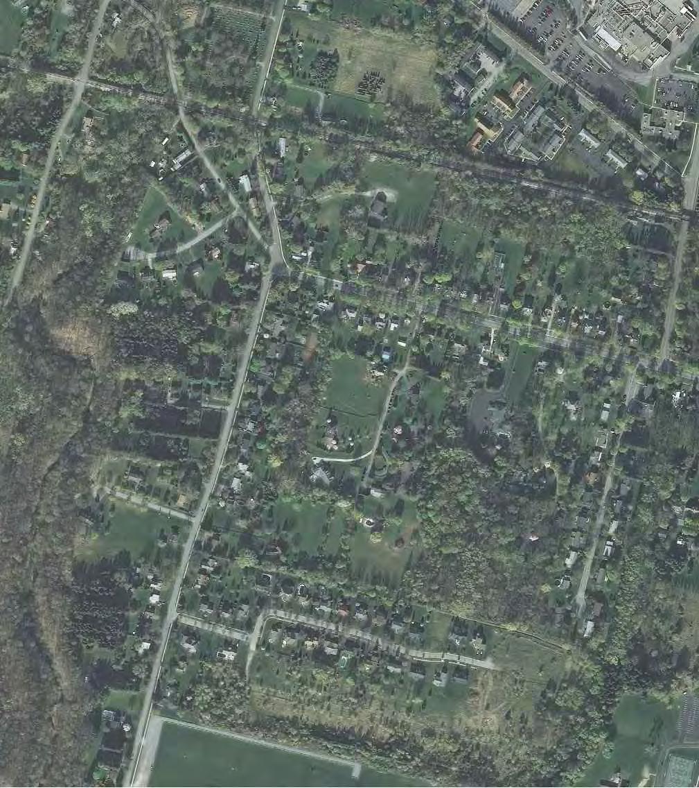
POLE BRIDGE ROAD NEAR FIVE LOT FARM
|
|
|
- Buck Washington
- 5 years ago
- Views:
Transcription

1
2
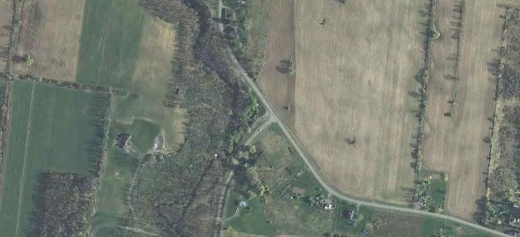
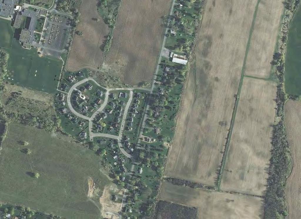
3 Drainage Improvements Village of Avon Pole Bridge Road near Five Lot Farm December 2014 POLE BRIDGE ROAD NEAR FIVE LOT FARM Pole Bridge Road is the eastern border of the Village south of NYS route 5 & 20. Five Lot Farm is a residential subdivision in the Village approximately 1,200 feet north of Lake Road. Stormwater runoff from the Town of Avon that crosses Pole Bridge Road near this location becomes the gully or drainage channel that flows along Pineview Heights towards Genesee and Spring Streets. During the extreme storm event in late July 2014, stormwater runoff overtopped the road near 320 Pole Bridge Road and at the Genesee Street/Spring Street intersection, and caused damage along Pineview Heights. The upland portion of the watershed in the Town is approximately 123 acres, consisting mostly of row crops with single-family residential along Pole Bridge Road. Stormwater runoff from this area is channelized into swales, and crosses Pole Bridge Road in three (3) separate locations: at 1957 (18 SICPP), 1937 (2x 12 CMPs), and 1917 Pole Bridge Road (1x 24 SICPP and 1x 12 CMP). The 18 SICPP and 2x 12 CMPs combine at 360 Pole Bridge Road (Alexander Crossing Lot 2) into a 36 SICPP that is the start of the drainage channel. During the extreme storm event in late July, flow was pipe full and projected into the channel approximately 10 to 12 feet downstream. There was no flooding associated with this storm system during this event. The 12 CMP at 1917 Pole Bridge Road is part of a system of 12 diameter piping that was designed to carry stormwater runoff around the house at 320 Pole Bridge Road. It crosses the street, entering a manhole in the front yard, then takes two 90-degree bends into the back yard, and a third bend to discharge into the drainage channel. Flooding has been an issue at this location for a number of years, most likely due to the inefficiency of the piping. A number of years ago, the Village DPW installed the 24 SICPP to eliminate the two of the 90-degree bends, which presumably eliminated most of the nuisance flooding experienced by the Village resident. However, during the extreme storm event in July the system was overwhelmed, and runoff flooded over the road and out of the manhole covers. In August 2014, the Village DPW installed a 12 overflow pipe to hopefully alleviate the problem. The Village should consider replacing or reconfiguring the entire system and abandoning or removing the erroneous piping. The material cost for the 24 diameter piping needed to carry flow from the first manhole to the channel is approximately $3,000. Once in the channel, stormwater runoff enters the Five Lot Farm stormwater management system, which is two detention ponds in series. The first pond is located behind 22 Carriage Lane and is controlled by a 6-foot diameter pre-cast concrete manhole outfall structure with a 36 diameter inlet and a 26 by 36 overflow grate. This first pond has a storage volume of approximately 439,000 gallons at the overflow, but only about 144,000 gallons before detained water floods neighboring residents. The second pond is located behind 22 Bridge Circle and is controlled by 6-foot square precast concrete manhole outfall structure with a 48 diameter inlet and a 26 by 36 overflow grate. The second pond has a storage volume of approximately 438,000 gallons at the overflow, with no foreseeable impact on the neighboring residents. The MRB Group Project No Page 1
4 Drainage Improvements Village of Avon Pole Bridge Road near Five Lot Farm December 2014 combined functional volume of both facilities is about 582,000 gallons, based upon preliminary survey conducted by MRB Group in October The ponds are the last structures before the drainage channel hits Genesee Street and the Village storm sewer system. It is our understanding that the ponds did little detention of the extreme storm event in July. Most likely due to the large (36 and 48 ) inlets on the outfall structures and small storage capacities of the ponds. The Five Lot Farm ponds, and the drainage channel between, are located on Village owned lands, or within drainage easements, from Pole Bridge Road to the Avon Central School District property downstream of the 2 nd outfall structure. The drainage channel is the natural divide between the Five Lot Farm subdivision, and the previously approved Alexander Crossing subdivision to the south. Design of the Alexander Crossing subdivision included a regional stormwater management facility to mitigate stormwater runoff from the upland areas. The design volume of this facility was approximately 1.9 million gallons (6 acre-feet), and reduced the peak runoff flow rate during a 5.5-inch 24-hour storm event by 40%. It was proposed to be constructed offline from the drainage channel on lands dedicated to the Village. Unfortunately, the developer abandoned the subdivision before the facility could be constructed and dedicated to the Village. Eventually, another developer may become interested in the property, and a regional facility could still be constructed. It seems clear that a regional stormwater facility in this area would be a benefit, as it would provide stormwater mitigation for the surrounding development and protect downstream properties and infrastructure. At the onset, there seems to be three (3) possible locations for such a facility to be located, each with its benefits and shortcomings. 1. Construct a stormwater management facility in the farm fields upstream of Pole Bridge Road in the Town of Avon. 2. Modify the existing Five Lot Farms detention facilities to better mitigate stormwater runoff. 3. Construct the designed Alexander Crossing regional stormwater management facility. As stated, stormwater runoff from the Town portion of the watershed crosses Pole Bridge Road at three (3) separate locations. The one with the flooding issue (320 Pole Bridge Road) is actually the smallest of the three sub-areas, but immediately upstream is a low area located adjacent to a hedgerow where a facility could be constructed. This facility would reduce the possibility of runoff overtopping Pole Bridge Road, but would have little benefit of reducing total flows further downstream (ie. Genesee Street). When considering the negotiations and agreements with the landowner(s) in the Town to construct and access the facility, and the future maintenance, the Village would be better served by improving the storm piping at 320 Pole Bridge Road. MRB Group modeled the existing Five Lot Farms ponds to determine whether simple modifications to the existing outfall structures would have an impact on peak flow rates MRB Group Project No Page 2
5 Drainage Improvements Village of Avon Pole Bridge Road near Five Lot Farm December 2014 during large storm events. Modification would include restricting the inlet pipe to lengthen detention time and reduce peak flow rate. Unfortunately, the ponds are too small, and restriction of the inlets only caused the ponds to overflow resulting in localized flooding with no reduction in peak flow rate. For the ponds to be effective regional facilities, they would have to be enlarged with the excavation extending beyond the lands and easements the Village holds currently. We recommend that the Village approach the owner of the former Alexander Crossing subdivision about easements to either construct the approved regional stormwater management facility, or modify the existing Five Lot Farms ponds. Alternatively, the Village could work with the School District about constructing a regional facility on their property. A similar discussion with the School District was held earlier this year to construct facilities farther downstream. Costs of constructing a regional facility will depend upon the arrangement with the land owner, the scope of the facility, and the intended use of the excavated material. However, the Village can anticipate Work within the drainage way would not require any permits as the channel is not classified as a stream and therefore not regulated by the New York State Department of Environmental Conservation. There are also no apparent wetlands in the area. Attached to this report is an overall map of the watershed, including the location of the existing Five Lot Farm ponds, and the discussed alternatives. MRB Group Project No Page 3
6
7


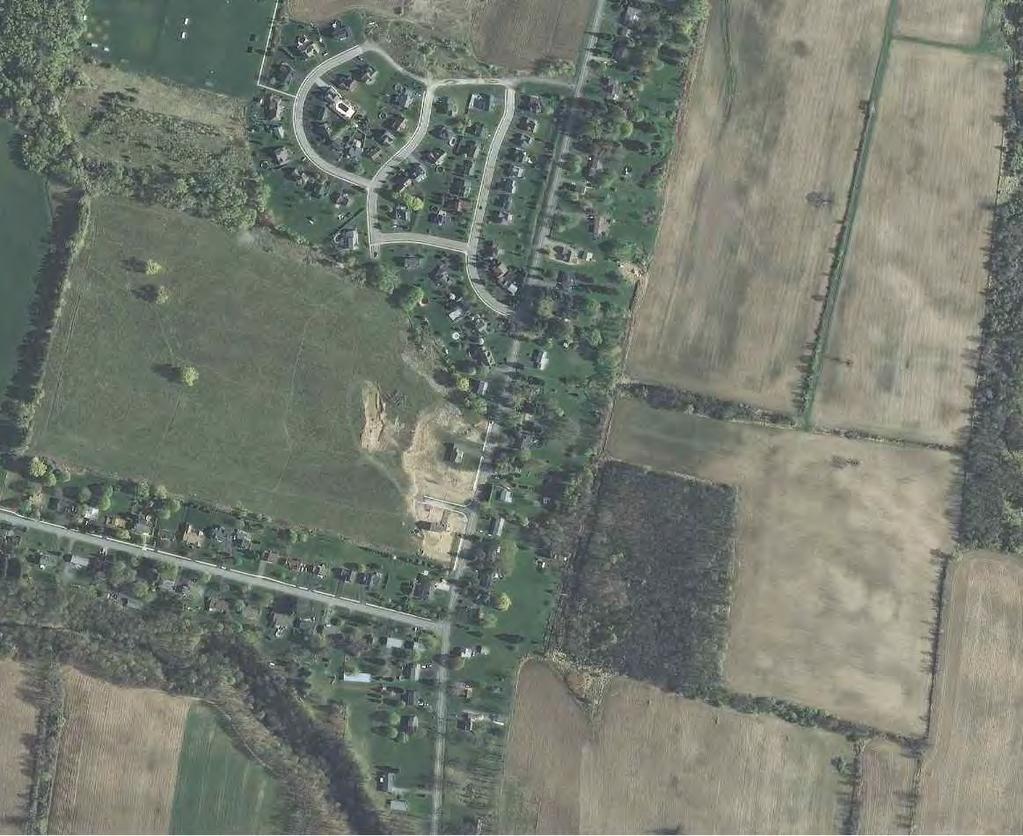
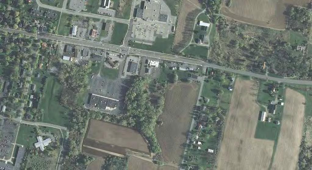
8 Drainage Improvements Village of Avon Genesee and Spring Streets December 2014 GENESEE AND SPRING STREETS The gully or drainage channel that begins at Five Lot Farms enters the Village storm sewer system at the Genesee and Spring Street intersection. During the extreme storm event in late July 2014, stormwater runoff overtopped the road at this intersection causing flooding and damage to adjacent Village and resident property. Construction of a regional stormwater management facility in the Five Lot Farm/Pole Bridge Road area would have a positive impact on flooding at Genesee Street, but there are some other issues along Spring Street and in the Village in general that should be considered. During the extreme storm event in July 2014, the high water in the channels picked up debris from the banks and carried it downstream. At Genesee Street, the debris caused damage to the culvert pipe, and clogged the manhole downstream. The debris restricted the manhole outlet pipe, backing up the storm sewer system and causing water to pop out of manholes and flood Spring Street. The Village should consider installing an angled rebar grate (as shown on the right) on the system inlet at Genesee Street, and any other system inlet subject to potential debris. An angled grate would have kept the larger debris from entering and clogging the system, potentially diminishing the flood impacts at Genesee and Spring Streets. Grating can be manufactured, or constructed from rebar. Cost will vary depending on the construction and size of the culvert. Approximately 700-feet down Spring Street from Genesee Street is a rail road trestle. The tracks run north-south, and carry drainage from the rear yards of homes on Genesee Street north towards Spring Street. According to Village DPW, the flow normally off the embankment onto Spring Street is a nuisance and not an issue; but during the extreme storm event in July 2014, the flow scoured the embankment, causing a deep rill and depositing debris onto Spring Street. To reduce the impact of flow over the embankment, the Village could consider providing a stabilized channel down the embankment to a drop inlet that is connected to the storm sewer system along Spring Street. MRB Group Project No Page 1
9 Drainage Improvements Village of Avon Genesee and Spring Streets December 2014 The picture showed a manufactured plastic system used on a highway at an overpass. Common construction would use rip-rap. Material cost is loosely estimated at $5,000 for the rip-rap, the drop inlet and miscellaneous piping. Finally, there is a 36 culvert that crosses Spring Street near the Kraft factory. During the extreme storm event in July 2014, the culvert overflowed and flooded the electrical station across the street. A large volume of storm water flows through this location, whose contributing watershed consists of everything captured by the Spring Street system (which includes Genesee Street up to Five Lot Farm and Pole Bridge Road), the Sackett Road system (which pickups drainage from Lake Road), and stormwater runoff off the Kraft campus. The total watershed area is approximately 500 acres. Since both areas are combine at this location, the improvements recommended in the Pole Bridge Road near Five Lot Farm and Sackett Road near the Hayes Property would have a positive impact on flooding. To further reduce the potential for flooding, the Village could also reroute the Sackett Road storm sewer to flow towards Little Conesus Creek and discuss onsite stormwater detention with Kraft. During the extreme storm event in July 2014, the ditch line on the west side of Sackett Road overflowed, flooding the Kraft parking lot. Rerouting the Sackett Road storm sewer would involve the replacement/construction of approximately 2,000 linear feet of ditches, piping and structures from the apartment complex driveway to the Little Conesus Creek gully. This, in concert with the Oak Hill Road interceptor, would significantly decrease flow rates and volumes in the Sackett Road ditch and at the Spring Street culvert. The cost of rerouting the Sackett Road storm sewer depends upon how much of the system could be ditched, and whether or not the Village proceeded with the Oak Hill Road interceptor. The Village would save money by coinciding the rerouting with any improvements or reconstruction of Sackett Road. The Village should also discuss with Kraft the possibility of adding stormwater detention on to their campus. It appears that at least the portions of the campus to the east (parking lots and administrative building) and north (loading docks) of the factory building drain towards Spring Street and the impacted culvert. Depending on how internal roof drains and onsite storm piping are connected, other portions of campus, including the factory building, might as well. To further reduce the impact to the Spring Street culvert and the flooding of their property, Kraft could consider providing onsite detention through traditional detention ponds or underground pipe storage. Attached to this report is a map of the general area, detailing the location of the discussed items. MRB Group Project No Page 2

10
11 Scoured banks around system inlet at Genesee Street.
12 Scoured embankment on Spring Street at railroad tressle.
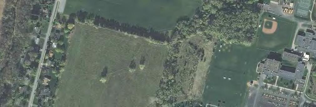
13
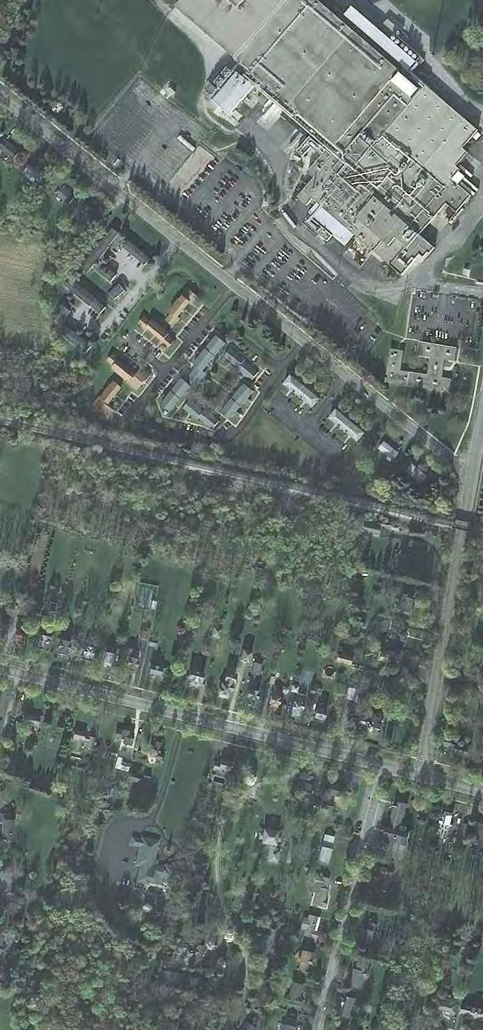
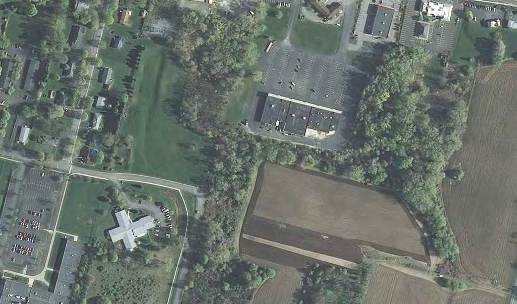
14 Drainage Improvements Village of Avon Sackett Road near the Hayes Property December 2014 SACKETT ROAD NEAR THE HAYES PROPERTY The Hayes property is located at 170 Sackett Road immediately south of the apartment complex (168 Sackett Road). During the smaller flash flood events, stormwater runoff would flood the Hayes backyard and basement. MRB Group walked the property and surrounding area with the Village DPW and observed the following: 1. Behind the Hayes property is a small drainage swale flowing north to a small culvert pipe that extends into the adjacent apartment complex (168 Sackett Road). It is unknown where the culvert leads, or if it requires any maintenance. 2. The small drainage swale is a short section of ditch that mostly picks up surface runoff from the adjacent field (233 and 235 Linden Street) to the east. 3. On the east side of 235 Linden Street is another ditch that carries flow from the east north towards the Community Manor apartments at Sackett Road. This ditch is not very well defined, and carries drainage from the rail road, Genesee Street, and Lake Road. 4. Along the south side of the Community Manor apartments is a culvert installed by Village DPW that directly connects to the Sackett Road storm sewer. It is our belief that during flash floods, the ditch along the east side of 235 Linden Street overflows across the field towards the Hayes property. In order to reduce the flooding impacts to the Hayes property and the general area, we propose the following options: 1. Improve the ditch line along the east side of 235 Linden Street to adequately convey the anticipated flows. 2. Construct a small detention facility in the basin created by the rail road embankment. 3. Install a storm sewer interceptor along Oak Hill Road. The watershed affecting the Hayes property during flash floods extends to the Lake Road/Pole Bridge Road intersection. Flows travel down two parallel systems, the storm sewer system along Lake Road, and the drainage path that flows through the Commerce Drive stormwater detention facility to a culvert behind 460 Genesee Street. That culvert along with the Lake Road storm sewer system, connect to the southern Genesee Street system that discharges into a ditch that runs westerly between 443 and 475 Genesee Street to the rail road embankment. At the embankment, the watershed area exceeds 80 acres. At the rail road embankment is a stone box culvert. It measures approximately 18- inches wide by 24-inches wide, and is constructed by laid up stones. The Village should approach the rail road and the neighboring property owners about placing an outlet structure on the culvert to restrict flow, and using the natural, depressed gully area as temporary detention during larger storm events. The outlet structure could be a catch basin, or upended pipe section with cored holes. The stone box culvert could be improved by lining it with a smaller diameter corrugated plastic pipe. This would extend the life of the culvert, while providing stormwater detention and reducing drainage impacts downstream. MRB Group Project No Page 1
15 Drainage Improvements Village of Avon Sackett Road near the Hayes Property December 2014 Additionally, the Village could reduce drainage impacts through interception. One specific location where this would be a benefit is on Oak Hill Road in the Town of Avon. Oak Hill Road is a short residential street that runs south from Lake Road to the Little Conesus Creek gully. It is approximately 500 feet west of Chamber Drive. An interceptor storm sewer installed here would reduce the watershed area at the rail road embankment from 80 acres to 42. Conceptual design shows the Village would need to install approximately 1,000 feet of 24 and 36 piping, and four (4) structures. Cost of these materials is roughly $38,000. Little Conesus Creek is a regulated stream, and the New York State DEC and Army Corps of Engineers would have to be consulted regarding permitting. Finally, the Village should improve the ditch along the east side of 235 Linden Street. The ditch is not very well defined, and could be enlarged to carry the necessary flow to the culvert at the Community Manor apartments. Attached to this report is a map of the general area, detailing the location of the discussed items. MRB Group Project No Page 2
16
17 Stone box culvert under rail road.
18
19
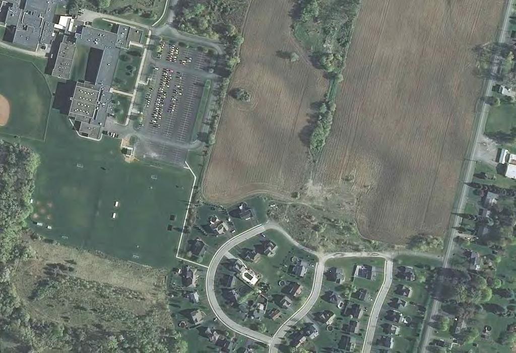
20 Drainage Improvements Village of Avon CVS Plaza and the Martin Property December 2014 CVS PLAZA AND THE MARTIN PROPERTY The CVS drug store is located at the southeast corner of the intersection of NYS Route 5 & 20, and Dream Valley Boulevard. The site was developed with an underground pipe storage system to mitigate the increase in storm water runoff resulting from the development. During flash storm events, such as the extreme event that occurred in July 2014, the underground pipe storage system overflows, flooding the parking lot and Dream Valley Boulevard. MRB Group walked the property and surrounding area with the Village DPW and observed the following: 1. Between CVS and the Tom Wahl s restaurant to the east is a shallow drainage ditch leading to a 12 corrugated metal pipe inlet to the storm sewer system along NYS Route 5 & The ditch is part of a drainage system whose watershed originates on the east side of Pole Bridge Road. 3. The drainage crosses Pole Bridge Road in three (3) separate culverts along the frontage of the school property. 4. The drainage then flows northwesterly through the Avon Central School District property, and into the Martin property. 5. Through the Martin property, the drainage is in a wooded area that extends along the eastern side of the plaza, and into the ditch between CVS and Tom Wahl s. 6. Through the storm sewer system, runoff from the ditch eventually ends up in the large detention facility due west of Tops. There have been previous concerns about the size of the pipe crossing NYS Route 5 & 20. It is our belief that during flash floods, the ditch along the east side of the CVS property overflows and floods the parking lot. In order to reduce the flooding impacts to the CVS property and the general area, we propose the following: 1. Improve the ditch line along the east side of the CVS property to adequately convey the anticipated flows. 2. Work with Mr. Martin or the Avon Central School District to construct a regional detention facility to reduce stormwater runoff rates and provide stormwater mitigation for potential development. 3. Install an interceptor swale along the rear of Pole Bridge Road properties in the Town of Avon. The watershed affecting the CVS property extends south and east, across Pole Bridge Road and into the Town of Avon, totaling approximately 75 acres. The area of agricultural field along the rear of properties on Pole Bridge Road is approximately 34 acres. According to LIDAR contour data, it appears possible to extend approximately 1,200-feet of swale along the western edge of the field, intercepting the drainage and re-directing it towards an existing culvert that crosses NYS Route 5 & 20. The interceptor swale would reduce the total areas contributing drainage to the CVS ditch to 41 acres, greatly reducing the volume of runoff. Since the NYS culvert, which is about 200-feet east of Pole Bridge Road, discharges into the same unnamed tributary of the Genesee MRB Group Project No Page 1
21 Drainage Improvements Village of Avon CVS Plaza and the Martin Property December 2014 River as the Tops detention facility, re-direction of runoff from the farm fields would not have a negative effect upon the watershed. However, the culvert, and another private culvert downstream, would have to be analyzed to ensure that the additional runoff would not have a negative effect. Additionally, the Village could also work with the Avon Central School District to construct a regional stormwater detention facility on their property. A farm lane runs along the northern boundary of the property and could be used by the Village for access to a facility that would reduce flows downstream. The facility would be created by replacing the existing culvert, raising the farm lane and excavating the pond to the south. An outlet structure would be installed reduce flows during varying rainfall events. Alternatively, the Village could work with Mr. Martin, the neighbor to the north. A facility on Mr. Martin s property would provide more benefit, but the facility should then also take into consideration the water quality and quantity mitigation required for any future development intended by Mr. Martin, making the resulting facility much larger in scope than what is needed by the Village. Whether a facility is constructed on the school or Mr. Martin s property, it could be sized to reduce the flows regardless of whether or not the interceptor is installed. If the interceptor is not installed, the facility would have to be larger to reduce the flows from the larger contributing area. Lastly, the Village should improve the ditch line along the east side of the CVS property, berming up the west side to carry additional flow, and reduce the amount of flow overflowing into the parking lot. Piping of the ditch may be possible, but would have to take into consideration runoff from the Tom Wahl s parking lot. There was little consideration into improving the storm system along NYS Route 5 & 20 for two reasons: 1. The design, permitting, and costs associated with working within the NYS right-ofway. 2. No guarantee that enhanced capacity in the NYS storm system would prevent runoff from overflowing the ditch bank into the CVS parking lot. Attached to this report is a map of the general area, detailing the location of the discussed items. MRB Group Project No Page 2
22
23
24 Drainage Improvements Village of Avon Hal-Bar Road Pond December 2014 HAL-BAR ROAD POND In 1997, the Village and Avon Central School District collaborated on a detention facility located north of Clinton Street Extension behind the homes on Hal-Bar Road. The main purpose of the facility was to reduce flooding impacts on the school from the runoff generated by the farm lands to the east. An interceptor system was installed that routed that flow around the school property to the Hal-Bar pond. The system consists mostly of a trench drain along the perimeter of the school pavement areas that outlets into a ditch on the north side of Clinton Street Extension. The stormwater then travels through a shallow ditch into the Hal-Bar pond. During the extreme storm event in July 2014, the pond worked successfully, and prevented any flooding of the adjacent neighbors on Hal-Bar Road. However, there was flooding of the lands north of the pond toward NYS Route 5 & 20, including the electrical station. The eastern side of the pond is slightly bermed, and cuts off the natural flow of runoff from an approximately 6-acre area that would have flowed westerly towards Hal-Bar Road. It is also possible that during the extreme storm event that the interceptor system and ditch leading to the Hal-Bar pond was overrun, and additional flow bypassed the pond and flooded towards the nearby electrical station and businesses. To eliminate this problem, the Village should consider enlarging the Hal-Bar pond to take on the additional drainage area and diverting all of the flow to the Village storm system along Hal-Bar Road. In 2002, this idea of enlarging the Hal-Bar pond was investigated in response to some conceptual development proposed at the Plaza and surrounding lands currently owned by Mr. Martin. The resulting conceptual design mitigated runoff generated during a 25-year storm event from these areas. It is our recommendation that this potential expansion of the Hal-Bar pond be revisited to address the flooding concerns. Attached to this report is a map of the general area, detailing the location of the discussed items. MRB Group Project No Page 1
25
26
CITY OF VALPARAISO STORMWATER MASTER PLAN
 CITY OF VALPARAISO STORMWATER MASTER PLAN APPROVED BY THE VALPARAISO CITY UTILITIES BOARD OCTOBER, 2016 Prepared by the City of Valparaiso Engineering Department PLAN SUMMARY Major flash flooding in August
continues in the watershed, additional flood control and water quality / natural system improvements may be required in the future.
 The Duck Pond Watershed is located in northern Hillsborough County in an area in which a number of land and water management issues are currently being addressed by citizen's action groups and state, regional
South Bismarck Watershed Model Update and Stormwater Improvement Project
 Preliminary Engineering Report Bismarck Tribune South Bismarck Watershed Model Update and Stormwater Improvement Project City of Bismarck, ND January 2017 14.105.0046 1.0 Executive Summary The focus of
HEALTH SCIENCES BUILDING REDEVELOPMENT PROJECT
 INTRODUCTION In recent years, the University of Cincinnati (University) has demonstrated a commitment to identifying and implementing sustainable goals and objectives throughout University s Uptown Campuses.
Why a new Food & Farm Ordinance?
 Growing for Kane Why a new Food & Farm Ordinance? 1. Growing obesity issue 64% of Kane adults are overweight or obese 2. Low rates of fruit & vegetable consumption Healthy diets include more fruits & veggies.
PROJECT SCOPE OF WORK CITY OF TOWN AND COUNTRY STORMWATER PROGRAM
 PROJECT SCOPE OF WORK CITY OF TOWN AND COUNTRY STORMWATER PROGRAM Project ID Number: 25-5 Problem: Stormwater collected from the neighborhood upstream is released at 9 Muirfield Lane and flows west toward
4. CONCEPT PLAN DEVELOPMENT
 4. CONCEPT PLAN DEVELOPMENT Concept Plan Step 1: Identify Site Constraints and Opportunities Review the existing site to identify constraints and opportunities for GI Practices to meet the RRv. Constraints
4. Contractor (and subcontractors if applicable) certification statement(s)
 certification statement(s)") CHEMUNG COUNTY STORMWATER COALITION STORMWATER POLLUTION PREVENTION PLAN (SWPPP) SUBMITTAL CHECKLIST GENERAL INFORMATION: 1. Owner/Operator name, legal address, phone number 2. Copy of signed Notice of
CHEMUNG COUNTY STORMWATER COALITION STORMWATER POLLUTION PREVENTION PLAN (SWPPP) SUBMITTAL CHECKLIST GENERAL INFORMATION: 1. Owner/Operator name, legal address, phone number 2. Copy of signed Notice of
City of Waco Stormwater Management Regulations
 1.0 Applicability: City of Waco Stormwater Management Regulations These regulations apply to all development within the limits of the City of Waco as well as to any subdivisions within the extra territorial
STORMWATER REPORT FOR WALMART SUPERCENTER STORE # SIOUX FALLS, LINCOLN COUNTY, SOUTH DAKOTA BFA PROJECT NO
 STORMWATER REPORT FOR WALMART SUPERCENTER STORE # 2443-00 SIOUX FALLS, LINCOLN COUNTY, SOUTH DAKOTA BFA PROJECT NO. 3286 March 1, 2012 I hereby certify that this engineering document was prepared by me
City of Elmhurst. City of Elmhurst. Storm Sewer System Workshop November 22, 2010
 City of Elmhurst City of Elmhurst Storm Sewer System Workshop November 22, 2010 1 City of Elmhurst Watershed divide (green dashed line) through Elmhurst Area east of divide drains to Addison Creek Area
City of Dade City AMEC Project No Dade City Stormwater Master Plan September 2012 Page 32
 Page 32 3.0 MAJOR DRAINAGE SYSTEMS The 1965 Master Plan Report for Storm Drainage Facilities ( 1965 Master Plan ) identified six primary subwatersheds within the Dade City study area. Each of these areas
LOUISIANA STATE UNIVERSITY COMPREHENSIVE & STRATEGIC CAMPUS MASTER PLAN. APPENDIX G - Stormwater Study Findings & Stormwater Solutions
 LOUISIANA STATE UNIVERSITY COMPREHENSIVE & STRATEGIC CAMPUS MASTER PLAN APPENDIX G - Stormwater Study Findings & Stormwater Solutions LSU: MP Narrative July 2017 3.5 Open Space Existing Conditions The
Table of Contents G.1.a Water Resources - Surface Water - Drainage
 Table of Contents G.1.a Water Resources - Surface Water - Drainage 1. INTRODUCTION... 1335 2. ENVIRONMENTAL SETTING... 1335 a. Regional Hydrology... 1335 b. Local Hydrology... 1337 c. On-site Hydrology...
Stormwater Regulations & Considerations Morse Study Area. Pam Fortun, P.E. CFM Senior Stormwater Treatment Engineer Engineering Services Division
 Stormwater Regulations & Considerations Morse Study Area Pam Fortun, P.E. CFM Senior Stormwater Treatment Engineer Engineering Services Division Stormwater Regulations Development Considerations Floodplain
C. WATER. 1. Surface Water Runoff. See Section C.3, Flood Hazard/Mudflow Hazard, page Ground Water
 C. WATER 1. Surface Water Runoff See Section C.3, Flood Hazard/Mudflow Hazard, page 67. 2. Ground Water Determined not significant by the October 1984 and January 1999 Initial Studies conducted by the
MASTER DEVELOPMENT DRAINAGE PLAN FOR MONUMENT HEIGHTS
 MASTER DEVELOPMENT DRAINAGE PLAN FOR MONUMENT HEIGHTS DRAINAGE REPORT STATEMENT ENGINEER'S STATEMENT: The attached drainage plan and report were prepared under my direction and supervision and are correct
Moon Brook FRP BMP Summary Sheet. Ownership of Land where BMP is Located
 Outlet Retrofit Hitzel Terrace The town owned parcel along Hitzel Terrace is a natural wetland area which currently provides some level of stormwater detention and peak-flow attenuation. The proposed project
City of Stoughton Erosion Control Permit Application (effective 2/6/2018)
") City of Stoughton Erosion Control Permit Application (effective 2/6/2018) Incomplete applications will not be accepted Project Name: Address of subject property: Landowner Name(s): Applicant Name: Landowner
City of Stoughton Erosion Control Permit Application (effective 2/6/2018) Incomplete applications will not be accepted Project Name: Address of subject property: Landowner Name(s): Applicant Name: Landowner
PRELIMINARY DRAINAGE REPORT LATHAM 200 MMSCFD GAS PROCESSING PLANT
 PRELIMINARY DRAINAGE REPORT LATHAM 200 MMSCFD GAS PROCESSING PLANT LOTS B, RECORDED EXEMPTION 1211-2-1, RECX13-0096 LOCATED IN THE NORTH 1/2 OF SECTION 2, TOWNSHIP 3 NORTH, RANGE 66 WEST, 6 TH PRINCIPAL
Urban Conservation Practice Physical Effects ESTABLISHMENT, GROWTH, AND HARVEST NUTRIENT MANAGEMENT
 NOT WELL 800 - Urban Stormwater Wetlands A constructed system of shallow pools that create growing conditions for wetland plants to lessen the impacts of stormwater quality and quantity in urban areas.
Old Mill Community Association Bioretention Facility
 Project Overview This project will install a bioretention facility in a community recreation area owned by the Old Mill Community Association, Inc. Drainage from the area is currently unmanaged and has
A. Regional Detention Requirements
 I. GENERAL DESIGN GUIDELINES A. Full-spectrum detention is provided for all new development, redevelopment or expansion of a site to provide for water quality and flood control detention. B. Detention
Lincoln 270. City of Lincoln. Stormwater Management Plan. April 2, 2013
 Lincoln 270 City of Lincoln Stormwater Management Plan April 2, 2013 # 2005.48 Prepared By: Civil Engineering Solutions, Inc. 590 E Street Lincoln, Ca 95648 (916) 645 5700 1.0 Background: The project site
Buckingham Lake Berkshire Pond Raft s Pond
 Buckingham Lake Berkshire Pond Raft s Pond Some Historical Facts and Other Information about This Waterbody Prepared and Presented By: Daniel R. Hershberg, P.E. & L.S. Managing Partner Hershberg & Hershberg
PROJECT SCOPE OF WORK CITY OF TOWN AND COUNTRY STORMWATER PROGRAM
 PROJECT SCOPE OF WORK CITY OF TOWN AND COUNTRY STORMWATER PROGRAM Project Name: 362 Featherstone Dr Project ID Number: 27-3 Problem: Anecdotal evidence suggests a natural spring exists in the backyard
East Montpelier SWMP Preliminary BMP Summary Sheet BMP ID #: 1 Site name: U-32 High School. Current site type
 East Montpelier SWMP Preliminary BMP Summary Sheet BMP ID #: 1 Site name: U-32 High School 930 Gallison Hill Rd, East Montpelier, VT Filter Berm, Sand Filter, Cistern / Rain Barrel, Gravel Wetland, Check
STAFFORD TRACT NORTH OF US90A 1.0 INTRODUCTION 1.1 OBJECTIVE
 1.0 INTRODUCTION 1.1 OBJECTIVE This report, prepared for submittal to TxDOT, analyzes existing and proposed detention facilities draining into the TxDOT US90A storm sewer system. The results of the detailed
Poisoned Park? How Exide s Lead Contamination Risks Frisco s Grand Park
 Frisco City Hall has big plans to transform Stewart Creek into a Grand Park with lots of water features for kids to play in. Poisoned Park? How Exide s Lead Contamination Risks Frisco s Grand Park But
OPERATIONS & MAINTENANCE MANUAL FOR POST CONSTRUCTION MEASURES
 OPERATIONS & MAINTENANCE MANUAL FOR POST CONSTRUCTION MEASURES THE CARMONY BUILDING PARAGON REALTY NORTH GREEN STREET BROWNSBURG, HENDRICKS COUNTY INDIANA 8365 Keystone Crossing, Suite 201 Indianapolis,
CHECKLIST FOR PHASE II DRAINAGE REPORT
 I. COVER SHEET CHECKLIST FOR PHASE II DRAINAGE REPORT A. Name of Project B. Address C. Owner D. Developer E. Engineer F. Submittal date and revision dates as applicable II. GENERAL LOCATION AND DESCRIPTION
Erosion & Sediment Control Plan Application Form & Checklist
 Erosion & Sediment Control Plan Application Form & Checklist GENERAL INFORMATION Application Date: Project Address: Tax Map / Parcel Number(s): PROPERTY OWNER / DEVELOPER Firm Name: Contact Person: Title:
Advance Engineering & Surveying PLLC
 Advance Engineering & Surveying, PLLC Consulting in: Civil & Environmental Engineering Land Surveying Land Development 11 Herbert Drive Phone: (518) 698-3772 Latham, N.Y. 12110 Email:ncostape@gmail.com
David Clark, P.E. RW Armstrong & Associates, Inc. June 20, 2012
 David Clark, P.E. RW Armstrong & Associates, Inc. June 20, 2012 The City of Indianapolis is undergoing the completion of RebuildIndy projects. Through Mayor Ballard s RebuildIndy initiative, investments
Hopwood Motorway Service Area, Worcestershire
 Hopwood Motorway Service Area, Worcestershire SuDS used Grass filter strip Stone collector trench Spillage basin Grass swale Balancing ponds Wetland ditch Wetland treatment Sub-surface collector trench
When planning stormwater management facilities, the following principles shall be applied where possible.
 2.0 Principles When planning stormwater management facilities, the following principles shall be applied where possible. 2.0.1 Drainage is a regional phenomenon that does not respect the boundaries between
Village of New Maryland. Storm Water Management Master Plan
 Village of New Maryland Storm Water Management Master Plan Village of New Maryland Storm Water Management Master Plan Fredericton Office 80 Bishop Drive Fredericton NB E3C 1B2 Canada Telephone: +1 506
CRYSTAL LAKE FLOODING STUDY
 Project #08223 CRYSTAL LAKE FLOODING STUDY PREPARED FOR: City of Crystal Lake 100 W. Municipal Complex Crystal Lake, Illinois 60039-0597 REVISED MARCH 19, 2009 26575 W. COMMERCE DRIVE, SUITE 601, VOLO,
Homeowners Guide to Stormwater BMP Maintenance
 Homeowners Guide to Stormwater BMP Maintenance What You Need to Know to Take Care of Your Property Rain Barrel Dry Well Rain Garden Pervious Asphalt Porous Pavers City of El Monte Stormwater BMP Management
Chagrin River Watershed Partners, Inc. Local Regulations. Amy H. Brennan (440)
") Chagrin River Watershed Partners, Inc. Local Regulations Amy H. Brennan (440) 975-3870 www.crwp.org abrennan@crwp.org July 9, 2013 Applicable Zoning and Building Codes Erosion and Sediment Control Grading
Chagrin River Watershed Partners, Inc. Local Regulations Amy H. Brennan (440) 975-3870 www.crwp.org abrennan@crwp.org July 9, 2013 Applicable Zoning and Building Codes Erosion and Sediment Control Grading
TIRZ 17/Redevelopment Authority Capital Improvements Plan Projects
 Gessner Widening: T-1701 What: Widen the road from a six-lane divided boulevard to an eight-lane divided boulevard street section, increase turn lanes, update traffic signal system, improve drainage by
Lake and Stream Restoration Project
 Pre-project Fact Sheet May 2012 Toledo Botanical Garden (TBG) is a 60 acre public garden visited by more than 120,000 people annually. It is located in Toledo, Ohio in the Ottawa River watershed within
Appendix E Outfall Identification Standard Operating Procedure
 Appendix E Outfall Identification Standard Operating Procedure Regulated Municipal Separate Storm Sewer System (MS4) Outfall Determination Standard Operating Procedure Department of Environmental Services
Town of Vershire Road Erosion Inventory Report
 Town of Vershire Road Erosion Inventory Report Taylor Valley Road. Photo taken by TRORC staff. Prepared by: 128 King Farm Road Woodstock, VT 05091 Inventory and report funded by the Vermont Agency of Transportation
RFP DRAINAGE OUTFALL DESIGN AND PERMITTING. Mandatory Meeting for Proposers August 15, 2015
 RFP 2018-02 DRAINAGE OUTFALL DESIGN AND PERMITTING Mandatory Meeting for Proposers August 15, 2015 IMPORTANT DATES August 15 th, 2:00pm August 17 th, 5:00pm August 22 nd, 5:00pm September 5 th, 2:00pm
6.1. INTRODUCTION 6.2. EXISTING CONDITIONS
 Chapter 6: Stormwater Management 6.1. INTRODUCTION This Chapter describes the current drainage patterns on the Project Site, the stormwater management system that is proposed as part of the Proposed Project,
C ity of Grande Prairie Development Services Department
 C ity of Grande Prairie Development Services Department FAIRWAY DEVELOPMENT OUTLINE PLAN OP 08 09 Approved April 6, 2009 Prepared by: Focus Corporation Table of Contents 1.0. Introduction 2 3 1.1. Plan
2018 Annual Landfill Inspection Report
 2018 Annual Landfill Inspection Report Landfill H.W. Pirkey Plant Southwestern Electric Power Company Hallsville, Texas December 17, 2018 Prepared for: Southwestern Electric Power Company H.W. Pirkey Plant
Town of Bolton Stormwater Retrofit Opportunities
 Town of Bolton Stormwater Retrofit Opportunities Prepared by the Warren County Soil and Water Conservation District For the Town of Bolton under the Lake George Park Commission Community Stormwater Grant
INFRASTRUCTURE EXISTING INFRASTRUCTURE A. Circulation B. Signals C. Drainage D. Utilities
 7.01. EXISTING INFRASTRUCTURE A. Circulation B. Signals C. Drainage D. Utilities 7.02. PROPOSED INFRASTRUCTURE A. Overall Concept B. Circulation C. Signals D. Drainage 7.03. INFRASTRUCTURE MAP A. Key Infrastructure
Level 1 Downstream Analysis
 Level 1 Downstream Analysis Newcastle Way Apartments Newcastle, Washington King County April 14, 2014 Revised July 10, 2014 Prepared by: Dean A. Furr, P.E. Reviewed by: Donald Scarberry, P.E. Coffman Engineering,
VALLEY VIEW POND Q&A. This item will be discussed under the First Reading portion of the agenda at the July 17, 2012 Village Council meeting.
 VALLEY VIEW POND Q&A This item will be discussed under the First Reading portion of the agenda at the July 17, 2012 Village Council meeting. 1. Please provide a history of the pond including Village maintenance
AWR Engineering, LLC
 AWR Engineering, LLC Alaska Water Resources Memorandum To: Kirsti Bischofberger, Watershed Manager, Municipality of Anchorage From: Janie Dusel, PE Date: February 3, 2017 Re: 2016 Low Impact Development/Green
Drexel, Barrell & Co.
 Drexel, Barrell & Co. December 21, 2018 Engineers/Surveyors Boulder Colorado Springs Greeley 3 South 7 th Street Colorado Springs, Colorado 80905-1501 719 260-0887 719 260-8352 Fax El Paso County Planning
Drexel, Barrell & Co.
 Drexel, Barrell & Co. June 18, 2018 Engineers/Surveyors Boulder Colorado Springs Greeley 3 South 7 th Street Colorado Springs, Colorado 80905-1501 719 260-0887 719 260-8352 Fax El Paso County Planning
2016 WORKSHOP LVR Field Trip
 2016 WORKSHOP LVR Field Trip ***Note*** Many of the sites on this tour were NOT related to, or funded by, the DGLVR program. They are being shown to encourage discussion about the kinds of projects that
SOUTH FOX MEADOW STORMWATER IMPROVEMENT PROJECT
 VILLAGE OF SCARSDALE WESTCHESTER COUNTY, NEW YORK COMPREHENSIVE STORM WATER MANAGEMENT SOUTH FOX MEADOW STORMWATER IMPROVEMENT PROJECT In association with WESTCHESTER COUNTY FLOOD MITIGATION PROGRAM Rob
Draft Rhode Island Stormwater Design and Installation Standards Manual
 Draft Rhode Island Stormwater Design and Installation Standards Manual Summary The May 2009 Public Review Draft version of the RI Stormwater Design and Installation Standards Manual consists of approximately
12/7/2007. Christopher B. Burke Engineering West, Ltd Aux Sable Creek Watershed Plan Update 1
 The ABC s of BMP s Aux Sable Watershed Plan St. Charles, IL Why are BMP s Important Best Management Practices (BMPs) developed as a set of practices which help to achieve goals of the Clean Water Act and
Section 11 Grading and Drainage Standards
 Section 11 Grading and Drainage Standards 11.1 INTRODUCTION The proper grading, conveyance, storage and release of storm water is critical to maintain the integrity of the Property. Drainage facilities,
Maintaining Your Neighborhood Stormwater Facilities How to identify stormwater facilities and keep them working
 Maintaining Your Neighborhood Stormwater Facilities How to identify stormwater facilities and keep them working Photo to go here Table of Contents Getting to know your Stormwater Facilities..3 Fences and
NAPA COUNTY PUBLIC WORKS Standards & Specifications
 Roadway Design & Construction Manual (Table of Contents) 1. Chapter 1: General Provisions 1.1 Short Title 1.2 Jurisdiction 1.3 Purpose and Effect 1.4 Enactment Authority 1.5 Amendment and Revisions 1.6
Meeting Overview. Key Takeaways ~ MERRICK I. Project: Globeville Stormwater System Study. Date and Time: 05/09/2018 from 5:30 pm 7:30 pm
 COLLABORATIVE=:'.:.:' 0 Project: Globeville Stormwater System Study Date and Time: 05/09/2018 from 5:30 pm 7:30 pm Meeting Name: Community Meeting #1 Meeting Place: Stapleton Recreation Center (5090 Broadway
Appendix K. Stormwater Management Plan
 Regional Municipality of Halton - Steeles Avenue (Regional Road 8) Class EA - Industrial Drive to Regional Road 25/Martin Street Appendix K Stormwater Management Plan PR226401.001 Rev. 2 PR.DOT, 00/01
WQ-23 MOUNTAINOUS AND STEEP SLOPE SITES
 Greenville County Technical Specification for: WQ-23 MOUNTAINOUS AND STEEP SLOPE SITES 1.0 Mountainous and Steep Slope Sites 1.1 Description The geographic locations of portions of Greenville County are
5. FINAL DEVELOPMENT PLAN APPROVAL MENORAH MEDICAL CENTER OFFICE BUILDING Vicinity of the southwest corner of 119 th Street and Nall Avenue
 5. FINAL DEVELOPMENT PLAN APPROVAL MENORAH MEDICAL CENTER Avenue 1. APPLICANT: Hoefer Wysocki Architects, L.L.C., is the applicant for this request. 2. REQUESTED ACTION: The applicant is requesting final
What is stormwater runoff? Why is it a problem? Available Financial Incentives for Stormwater BMP s Downspout Disconnection - up to $20
 What is stormwater runoff? Stormwater is any form of natural precipitation (including ice and snow melt) that flows across undeveloped or developed land. In a natural setting, a majority of the water seeps
Public Information Centre # 2 Coronation Park Drainage Improvements Town of Oakville Municipal Class Environmental Assessment
 November 26, 2014 Public Information Centre # 2 Coronation Park Drainage Improvements Town of Oakville Municipal Class Environmental Assessment Study Area & Drainage System Legend Coronation Project Park
Figure 1 Cypress Street Study Area Location Map
 July 20, 2016 TO: FROM: Jim Massarelli Director of Engineering Jeff Julkowski, PE Michael Burke, PE SUBJECT: Cypress Street Study Area Stormwater Analysis (CBBEL Project No. 16-0058) At the request of
5-Year Street Reconstruction Plan ( )
") 5-Year Street Reconstruction Plan (2006-2010) City of Delano Wenck File #0564-37 Prepared for: CITY OF DELANO 234 2 nd Street West Delano, MN 55328 Prepared by: WENCK ASSOCIATES, INC. 1800 Pioneer Creek
5-Year Street Reconstruction Plan (2006-2010) City of Delano Wenck File #0564-37 Prepared for: CITY OF DELANO 234 2 nd Street West Delano, MN 55328 Prepared by: WENCK ASSOCIATES, INC. 1800 Pioneer Creek
A. INTRODUCTION AND SUMMARY OF FINDINGS B. EXISTING CONDITIONS. Table 10-1 Adjacent Storm Drains
 Chapter 10: Stormwater Management A. INTRODUCTION AND SUMMARY OF FINDINGS This chapter describes existing and proposed stormwater management on the Site. Potential impacts to stormwater infrastructure
Brigitte A. Berger, Director of Engineering
 Brigitte A. Berger, Director of Engineering Wilmette s Sewer System Overview of Wilmette s Sewer System Green vs. Gray? Stormwater Action Plan Regulatory Compliance Why Homes Flood What can
MANUAL OF DESIGN, INSTALLATION, AND MAINTENANCE REQUIREMENTS FOR STORMWATER MANAGEMENT PLANS
 MANUAL OF DESIGN, INSTALLATION, AND MAINTENANCE REQUIREMENTS FOR STORMWATER MANAGEMENT PLANS May 2007 SECTION 1 Responsibility of Applicant TABLE OF CONTENTS A. Stormwater Management Plan Required Information
Maintaining Your Neighborhood Stormwater Facilities
 Maintaining Your Neighborhood Stormwater Facilities How to identify stormwater facilities and keep them working Layout by the Thurston County Storm and Surface Water Utility with thanks to the Delaware
Tentatively Selected Plan within Harlem River, East River and Western Long Island Sound Planning Region. First Level Costs. Federal Non-Federal Total
 HARLEM RIVER, EAST RIVER AND WESTERN LONG ISLAND SOUND PLANNING REGION Flushing Bay and Creek Ecosystem Restoration Source Feasibility Study Background Study Resolution (1994), Reconnaissance Report (1996),
Village of Forest Park. July 27, Sewer Separation Evaluation
 Village of Forest Park July 27, 2015 Sewer Separation Evaluation Presentation Overview Study Background Historic Nature of Forest Park Drainage Scale of Flooding Problem Forest Park Sewer System Background
BRISBANE BAYLANDS INFRASTRUCTURE PLAN FEBRUARY 2011 APPENDIX O DRAFT
 BRISBANE BAYLANDS INFRASTRUCTURE PLAN FEBRUARY 2011 APPENDIX O DRAFT PRELIMINARY STORM DRAIN CALCULATIONS ASSOCIATED WITH BRISBANE BAYLANDS REDEVELOPMENT BRISBANE, CALIFORNIA Prepared by BKF Engineers
SITE PLAN REVIEW ITEMS - REFERENCE CHECKLIST
 City of Seminole 9199 113 th Street N. Seminole, FL 33772 Ph: (727) 392-1966 Fx: (727) 319-6583 SITE PLAN REVIEW ITEMS - REFERENCE CHECKLIST Note: This checklist is designed to aid designers in the review
2 ALTERNATIVES AND OPTIONS
 2 ALTERNATIVES AND OPTIONS This chapter documents the process used to develop improvement concepts for Oregon Avenue and describes the resulting project alternatives and options, which were developed in
Severn River Sub-Watershed: BMP 09-Retrofit
 Project ID: BMP_09 Total Treated Drainage Area: 4.57 acres Total Treated Impervious Area: 2.9 acres Total Water Quality Volume (WQv): ~10,300 cubic feet; 0.236 acre-foot Rainfall Depth Treated (Pe): 1
Notice of Preparation of an Environmental Impact Report and Scoping Meeting for the Canyon Lane Roadway Improvements Development Project
 of an Environmental Impact Report and Scoping Meeting for the As the Lead Agency, the County of San Mateo (County) will prepare an Environmental Impact Report (EIR) for the (project), and would like your
STORMWATER - GENERAL NOTES
 STORM DRAINAGE CONSTRUCTION NOTES. All storm sewer pipe shall be reinforced concrete. 2. Storm drainage pipes shall be a minimum of fifteen (5) inch diameter (5" for short lateral runs only - up to 75
13. PRELIMINARY PLAT NO MILLS FARM - Vicinity of the southeast corner of 159 th Street and Quivira Road
 13. corner of 159 th Street and Quivira Road 1. APPLICANT: HNTB Corporation is the applicant for this request. 2. REQUESTED ACTION: The applicant is requesting approval of a preliminary plat for a 383-lot
Swatara Township Stormwater Program. 1. There are no storm sewers on or near my property. Why should I pay a fee?
 1. There are no storm sewers on or near my property. Why should I pay a fee? All properties produce stormwater runoff that must be managed by the Township. Even if your property has never flooded and there
PARISH OF ASCENSION OFFICE OF PLANNING AND DEVELOPMENT PLANNING DEPARTMENT. Joint Planning and Zoning Meeting
 1. Call To Order 2. Roll Call of Members 3. Chairman's Comments PARISH OF ASCENSION OFFICE OF PLANNING AND DEVELOPMENT PLANNING DEPARTMENT Joint Planning and Zoning Meeting January 11, 2017 6:00 PM Courthouse
Pollutant Removal Benefits
 Bioswales Bioswales Similar to biocells, but have a slight, but positive grade toward an outlet Designed to convey the WQv event at very low velocities Promote filtration through native vegetation, infiltration
Shelbyville, KY Stormwater Best Management Practices. Section 2 EROSION PREVENTION AND SEDIMENT CONTROL PLAN
 Section 2 EROSION PREVENTION AND SEDIMENT CONTROL PLAN 2.1 Requirements The City of Shelbyville, KY will require an Erosion Prevention and Sediment Control (EPSC) Plan for most types of development construction.
ATTACHMENT A STORMWATER MANAGEMENT TECHNIQUES Cahill Associates Environmental Consultants
 ATTACHMENT A STORMWATER MANAGEMENT TECHNIQUES New Development/Redevelopment Techniques Porous Bituminous Pavement Porous Bituminous Pavement is standard asphalt in which the fines have been held to a minimum,
Case 1:85-cv RGS Document 1769 Filed 06/15/12 Page 1 of 13. UNITED STATES DISTRICT COURT for the DISTRICT OF MASSACHUSETTS
 Case 1:85-cv-00489-RGS Document 1769 Filed 06/15/12 Page 1 of 13 UNITED STATES DISTRICT COURT for the DISTRICT OF MASSACHUSETTS UNITED STATES OF AMERICA, Plaintiff, CIVIL ACTION v. No. 85-0489-RGS METROPOLITAN
15. Wetlands Chapter Overview Introduction
 15. Wetlands 15.1. Chapter Overview 15.1.1. Introduction Pursuant to Presidential Executive Order 11990 entitled Protection of Wetlands, the United States Department of Transportation (USDOT) developed
CAPE ELIZABETH, MAINE TOWN CENTER STORMWATER MANAGEMENT PLAN UPDATE
 CAPE ELIZABETH, MAINE TOWN CENTER STORMWATER MANAGEMENT PLAN UPDATE September 2015 This report was prepared by The Town of Cape Elizabeth under award CZM NA14NOS4190066 to the Maine Coastal Program from
Evaluating Low Impact Development Practices for Stormwater Management on an Industrial Site in Mississippi
 Evaluating Low Impact Development Practices for Stormwater Management on an Industrial Site in Mississippi Dennis S. Painter, Tennessee Valley Authority, Nashville, Tennessee Donald Becker, Tennessee Valley
Zoning Regulation Amendments Adopted December 19, 2018 effective date January 7, 2019
 Zoning Regulation Amendments Adopted December 19, 2018 effective date January 7, 2019 Article 2 General Provisions Section 2.2 Definitions Definitions- FIRE LANE The aisle immediately adjacent to a building
PHASE III DRAINAGE REPORT
 PHASE III DRAINAGE REPORT FOR Eastlake Assisted Living & Memory Care April 20, 2016 June 3, 2016 August 5, 2016 Prepared for: 3301 E 120 th Ave, LLC. 8200 E. Maplewood Ave., Suite 150 Greenwood Village
Stormwater Management Techniques WMPF LAND USE TRAINING INSTITUTE MARCH 14, 2018
 Stormwater Management Techniques WMPF LAND USE TRAINING INSTITUTE MARCH 14, 2018 Potential Impacts of New Development Urban development can significantly increase stormwater runoff Water quality considerations
Storm Water Quality and Shoreline Restoration Improvements - Grant Funding Request City of Mound Carlson Park Bolton & Menk Project No.
 September 15, 2016 Brett Eidem Cost Share Grant Administrator Minnehaha Creek Watershed District 15320 Minnetonka Boulevard Minnetonka, MN 55345 RE: Storm Water Quality and Shoreline Restoration Improvements
TOWN OF ESOPUS REQUEST FOR PROPOSAL Stormwater Infrastructure Assessment and Drainage Capital Improvement Plan
 TOWN OF ESOPUS REQUEST FOR PROPOSAL Stormwater Infrastructure Assessment and Drainage Capital Improvement Plan The Town of Esopus, 284 Broadway, Ulster Park, New York is soliciting proposals from qualified
PCE PRELIMINARY DRAINAGE ANALYSIS REPORT FOR WESTWOOD MIXED USE NEIGHBORHOOD PROJECT 772 NORTH FOREST ROAD TOWN OF AMHERST, ERIE COUNTY, NEW YORK
 PCE PRELIMINARY DRAINAGE ANALYSIS REPORT FOR WESTWOOD MIXED USE NEIGHBORHOOD PROJECT 772 NORTH FOREST ROAD TOWN OF AMHERST, ERIE COUNTY, NEW YORK MAY 19, 2014 Prepared By: Timothy M. Lavocat, P.E., CFM
Stormwater Retrofitting: The Art of Opportunity. Presented by the Center for Watershed Protection
 Stormwater Retrofitting: The Art of Opportunity Presented by the Center for Watershed Protection What Are Stormwater Retrofits? Retrofits are stormwater management measures inserted in an urban or ultra-urban
SECTION 6. Routine Maintenance Activity Details
 SECTION 6 Routine Maintenance Activity Details 80. DEBRIS REMOVAL When Deadfall, and other objects, such as shopping carts, tires, appliances, and mattresses have accumulated in the drain. Why To prevent