BERENGRAVE NURSERY Design and Access Statement
|
|
|
- Walter Anthony
- 5 years ago
- Views:
Transcription
1 BERENGRAVE NURSERY Design and Access Statement
2 This document has been prepared by: Richards Urban Design Ltd The Design Chapel Cemetery Road Southampton SO15 7NN 2 LAND AT BERENGRAVE LANE, RAINHAM Design and Access Statement
3 00 CONTENTS 01 INTRODUCTION Page 4 04 EVALUATION AND RATIONALE Page 18 Purpose Structure of document 02 SITE ASSESSMENT Location and context Description Landscape Ecology Movement and access Cultural Heritage Character of development Appearance and materials Page 6 Design team Developing a masterplan Strategic Objectives Development Concept 05 ENGAGEMENT Local Planning Authority Community Engagement 06 DESIGN AND ACCESS Page 22 Page POLICY EVALUATION The Development Plan National Planning Policy Framework Page 16 Amount Layout Use Scale and massing Appearance and materials Landscape Access Drainage Sustainability Secured By Design Building for Life Lifetime Homes 07 SUMMARY AND CONCLUSIONS Page 50 Note: Plans and drawings within this document are based on Ordnance Survey (c) Copyright. All rights reserved LAND AT BERENGRAVE LANE, RAINHAM Design and Access Statement 3

4 N FIGURE 1. Aerial photograph of the site Bloors Lane Community Woodland BERENGRAVE LANE Rainham Cricket Club 4 LAND AT BERENGRAVE LANE, RAINHAM Design and Access Statement
 planning practice guidance and CABE document entitled Design and Access Statements - How to Write, Read and Use Them.")
5 01 INTRODUCTION Purpose This document comprises a Design and Access Statement and is produced in accordance with the guidance contained within the Department for Communities and Local Government (DCLG) planning practice guidance and CABE document entitled Design and Access Statements - How to Write, Read and Use Them. This document has been prepared to support an outline planning application under the Town and Country Planning Act 1990, on land at Berengrave Lane, Rainham, Kent. The application is submitted on behalf of Gleeson Developments Ltd and is an outline planning application with all matters reserved except access and comprises the following: Outline Planning Application (with all matters reserved except for means of access) for demolition of existing structures and erection of up to 121 residential dwellings including new vehicle access, internal roads, car parking, open spaces, sustainable urban drainage systems, earthworks and associated landscaping and infrastructure. This statement explains the design rationale behind the planning application and shows how the applicant is intending to create a place for the benefit of existing and future residents of Rainham. The statement and planning application uses drawings, photographs and illustrations to show how the site might be developed in the future and should be read in conjunction with the other plans and documents which comprise the planning application. The applicant has made a strong commitment to delivering a high quality scheme on the site and will use this document to demonstrate fully to both the community and Local Authority how this can be achieved. Structure of the document This statement sets out an assessment of the site from a design, access and planning perspective. It illustrates the way the design has evolved, before showing how the approach chosen for the application offers the best solution in terms of use, access and design. Section 2 of the document provides a thorough assessment of the site including its physical, social and economic characteristics. It explores the context of the site and its surroundings including the relationship of the site to Rainham and the wider area. Section 3 provides a summary of the relevant policy framework for the site. A separate supporting planning statement has been submitted as part of the application. Section 4 provides an evaluation of the site. These include the key constraints and opportunities for the site and the vision and key objectives which will help create its distinct character and appearance. Section 5 explains the process of engagement which has taken place and how the feedback has been incorporated into the scheme. Section 6 provides details of the design solutions being adopted using illustrations and plans to show how the vision and objectives will be achieved in built form and landscape. Section 7 is a summary of the proposals and concludes the document. FIGURE 2. Site location LAND AT BERENGRAVE LANE, RAINHAM Design and Access Statement 5

6 FIGURE Aerial Context photograph plan of the site KEY N The site Recreation uses School Church Shopping Children s Play Area Allotments Nature Reserve / Community woodland Primary Road Network Public Right of Way Bus route Bus stop Rail Station National Cycle Route 1 Listed Building Conservation Area 6 LAND AT BERENGRAVE LANE, RAINHAM Design and Access Statement

 from the town centre.")

 to the west. National Cycle Route 1, which extends across the east coast of England, runs through the town and runs very close the site, along Berengrave Lane and Childscroft Road.")

7 02 SITE ASSESSMENT Location and context The town of Rainham is a part of the Medway Towns conurbation in the county of Kent. Historically, Rainham was a separate village until, in 1928, it was added to the Municipal Borough of Gillingham, which had itself been created in Figure 1. is an aerial photograph of the existing site. Figure 2. shows the location of the site and Figure 3. shows the site in it s immediate context. The site is within a 15 minute walk from Rainham Station The M2 motorway runs along its southern edge of the town, two miles (6 km) from the town centre. The main road through the town centre, the A2, follows the ancient Watling Street, the Roman road between London and Canterbury. The most northerly road. Lower Rainham Road runs close to the southern bank of the river. The Chatham Main Line has a railway station in Rainham just north of the town centre with regular services to London Victoria with travel times at around 1 hr. London is approximately 39 miles (62.4 km) to the west. National Cycle Route 1, which extends across the east coast of England, runs through the town and runs very close the site, along Berengrave Lane and Childscroft Road. Bloors Lane Community Woodland adjacent to the site The site lies on the northern edge the existing built up area for the town. The south western boundary is defined by the railway line and the south eastern boundary by Berengrave Lane. Regular bus services operate close to the site The site lies adjacent to the National Cycle Network Route 1 To the north west is Bloors Lane Community Woodland and Berengrave Nature Reserve lies to the north east of the site, further along Berengrave Lane. Berengrave Lane has residential development on both sides of the street with some residential curtilages extending north west beyond the existing built up area for the town. Rainham Cricket Ground lies just to the south of the site Public Rights of Way, adjacent to and within the site LAND AT BERENGRAVE LANE, RAINHAM Design and Access Statement 7
8 FIGURE 4. Land ownership plan N 8 LAND AT BERENGRAVE LANE, RAINHAM Design and Access Statement


9 Description Figure 4. shows the extent of the site (edged red) which measures 5.8 hectares / 14.3 acres. The site comprises a plant nursery including the following elements: Open car parking area at the southern end of the site A number of display areas at the front of the site with associated buildings and structures Plant growing areas within the site including meshed tunnel structures Open storage areas within the site with a number of associated buildings Areas of scrub and planting within the northern part of the site A grassed area which has been cleared for use as an archery range The main car park at the southern end of the site with a range of display buildings and the main nursery building There is a single residential property, directly to the north east of the site boundary which was formerly used as part of the nursery site. Further north of this dwelling is a group of storage buildings and a telecoms mast. These area accessed from a driveway which runs along the edge of the site. There are public footpaths which run along the north eastern boundary (outside of the site) and through the northern part of the site (within the site). Landscape Topography The plant nursery growing and display areas meshed structures Rainham is located on the dip slope of the South Kent Downs where it descends gently to the River Medway; its maximum height is about 125m above sea level. The site falls at the northern edge of the town with the river some 1km to the north and the South Kent Downs AONB some 3km to the south, and beyond the built up area of Rainham. The site land appears flat although there is a gentle rise from north-east (c.17m above Ordnance Datum (aod)) to south-west (c. 28m aod). The site is broadly at grade with adjacent land except to the southwest where the boundary abuts the rising embankment of the Chatham Main Line beyond which the land rises across the settlement to the south.

 to manage")
10 Drainage The site does not lie within land at risk from flooding from rivers or the sea. There is an small area of at the frontage of the site which is at medium risk of flooding from surface water and some areas which are considered at low risk from surface water flooding within the centre of the site. Drainage proposals will need to ensure that there is no increase in the level of surface water run off from the site and will need to utilise sustainable urban drainage systems (SuDS) to manage surface water within the site. Vegetation The site comprises Berengrave Plant Nursery which can broadly be divided into two character areas: south-eastern site area, adjacent to Berengrave Lane, which still has a commercial function and character; and the remainder of the site beyond, which is largely unused and overgrown. The landscape fabric and habitats across the site are consistent with these broad areas as below and described in detail in the Arboriculture and Ecological assessments undertaken by The Ecology Partnership. View from within the site showing the scrub and unmanaged grassland The south-eastern area of the site comprises commercial areas fronting Berengrave Road including sales sheds, plant sales areas (open and in pollytunnels), and a tarmac surfaced car park with a more functional storage and loading area to the north-west. Vegetation here comprises an overgrown beech hedge and decorative tree species along the road and scattered between the nursery fabric, and native vegetation along the railway line; The north-western site area is largely covered by an area of hawthorn scrub with occasional semi-mature to early mature broadleaf nursery tree stock. Two broad bands of this vegetation type, separated by a rectangular area of improved grassland used as an archery range, extend from this area to, and along, the north-eastern boundary. This vegetation type is identified as Priority Habitat; The north-western boundary is marked by a hedgerow on a low bank, which appears to follow an historic field boundary line. A broad band of rough-semi improved grassland and scattered saplings and scrub, and including an area of overgrown allotments, runs along this boundary. Area of open grassland within the site used for archery 10 LAND AT BERENGRAVE LANE, RAINHAM Design and Access Statement


11 Views The site is visually very contained with very limited opportunity for visual interconnectivity between the site and its context except along Berengrave Lane. Visibility into the application site is primarily limited to: users of Berengrave Lane, adjacent to the site and for some 50m beyond its boundaries, train users, notably where the line it is raised on embankment; the PRoW crossing, and running adjacent to, the site boundary, and facing residential properties south-east of Berengrave Lane and the bungalow adjacent to the eastern site boundary. There is also potential for glimpsed, filtered, views, over intervening vegetation, from the community woodland to the north-west, and from residential properties, and the cricket ground, immediately south of the railway line. The main determinants of visibility comprise: Growing area in the central part of the site North-west: The hedge along the north-western site boundary, and semi-mature vegetation across Bloors Lane Community Woodland beyond, substantially limits visibility to the north-west; North-east: Visibility into the site from the PRoW to the north-east is substantially limited by dense scrub and woodland within the site, to the north, and by the intervening nursery buildings, and the bungalow, to the south. While there will be views into the site from the adjacent, facing, bungalow, this vegetation, together with the mature gardens and gently falling topography beyond, substantially restricts visibility from further afield; South-east: Intermittent trees and scrub along the site boundary, and the railway bridge, limit views into the site from Berengrave Lane to intermittent, glimpsed, filtered views from the road, where it is adjacent, and some 50m beyond the site boundaries. Visibility into the site is similarly limited for properties facing the site across Berengrave Lane with the potential for more distant views substantially limited by these fronting properties; South-west: To the south-west there will be visibility into the site from trains, where on site vegetation allows, however visibility from beyond will be substantially limited by the rising railway embankment, to the south, and woodland within the site, to the north. There is some visibility from properties backing onto the railway but the potential for more distant views is limited by these properties immediately beyond the railway. Existing access into the rear of the site with storage barn and dwelling on Berengrave Lane to the north east of the site LAND AT BERENGRAVE LANE, RAINHAM Design and Access Statement 11
12 Ecology An ecological survey was carried out in 2017 by The Ecology Partnership. The survey incorporated detailed assessment of the land within the development boundary, including a description and mapping of all key features and habitat types. The survey was carried out to identify the range of habitats within the site and the predominant and notable species of flora. A background data search was carried out in accordance with the Guidelines for Accessing and Using Biodiversity Data, CIEEM (2016) and Guidelines for Preliminary Ecological Appraisal, CIEEM (2013). A search for notable sites and species within a radius of 1km from the site perimeter was assessed as being appropriate considering the scale of development and characteristics of the surrounding landscape. Designated Sites The site is not designated for its nature conservation value, however, the site lies within 700m of Medway Estuary and Marshes Special Protection Area (SPA), Site of Special Scientific Interest (SSSI) and Ramsar. Additionally there are other internationality designated sites within 10km, including Queensdown Warren SAC within 4km and Thames Estuary and Marshes SPA and Ramsar site approximately 9.4km form the re line boundary. Locally designated sites include Berengrave Chalk Pit Local Nature Reserve (LNR) 200m east of the site. In addition, the community woodland, Bloor s Lane Community Woodland, is located adjacent to the site. Habitats The site was dominated by large areas of deciduous woodland edged with areas of dense scrub; an area of rough neutral semi-improved grassland; improved grassland archery range and mature trees around the edges of the site. Part of the site is a commercial area including a working nursery and a conservatory and shed sales area. Lowland deciduous woodland is a priority habitats s41 NERC Act, however, the site is dominated by self seeded more scrubby habitat, which is considered to be low quality scrubland rather than more well defined woodland. The mature trees around the edges of the site are considered to be of intrinsic value and are to be retained. The semi improved neutral grassland is specs poor with some ruderal species and encroaching scrub. These features are of site value only. Species Species specific surveys for bats, dormice, birds and reptiles have been commissioned. A good population of slow worms and common lizards are present on site. As such a mitigation strategy will be required in order to safeguard these species. The bird survey confirmed species which are largely common. However, turtle dove were recorded using the edge of the site along the site community woodland. These species are considered to be of conservation interest. House sparrow, starring, song thrush, dunnock and potentially bullfinch are all found to be present using the site. A mitigation strategy has been recommended to accommodate these species. This includes native species planting, shrub and scrub panting of species which support berries, the increase of nesting boxes on site, including house sparrow boxes on houses, and recommendations for planting within gardens and open grassland habitats. Bat surveys are on going and will be completed in October Dormouse surveys are on going and will be completed in November No dormice have been recorded so far during the survey period. Potential for ecological enhancement The proposals will include the long term management and maintenance of the retained woodland, creating an opportunity to enhanced the currently scrubby habitat. The long term management of this woodland will provide a greater benefit in terms of local biodiversity. Bat and bird boxes will be established in this woodland, alongside additional boxes secured on buildings, to provide new nesting and roosting features. In addition, the site will be planted with a range of native species, including species which are berry bearing, to support the local bird population. Wildflower areas will be developed and a nature area, where the reptiles will be relocated to, will be enhanced to support the reptile population and to provide opportunities for a range of species, including small mammals and invertebrates. Movement and access Vehicular access The site location to the east of Berengrave Lane provides a good length of site frontage over which to provide a new access location. Berengrave Lane is a single lane two-way carriageway (approximately 6.5m wide) with pavements (1.8-2m wide) on both sides with the exception of the site frontage and Rainham Cricket Club. To the south of the site the road narrows to pass under a railway bridge. Pedestrian and cycle access The site it is well located to the local facilities within the town including the town centre, station, schools and recreational facilities within 15 minutes walk of the site. National Cycle Route 1, which extends across the east coast of England, runs through the town and runs very close the site, along Berengrave Lane and Childscroft Road. A further shared footway/cycleway is provide along the northern side of the A3 to the south, providing a direct route from Rainham Town Centre to the west Rights of way There are two Public Rights of Way in close proximity of the site (see Figure 3). Public Right of Way no. GB5 runs along the north eastern boundary (outside of the site) connecting Berengave Lane to Lower Bloors Lane. Public Right of Way no. GB6 runs through the site linking Lower Bloors Lane to footpath no. GB5. At the southern end of Bloors Lane there is a pedestrian footbridge crossing the railway line, providing pedestrian access through to Pembury Way and Beechings Way. Much of this route is unlit with limited overlooking. Public Transport The closest bus stops to the site are located on Childscroft Road, approximately 250m to the east of the centre of the site. Facilities in the form of bus stop flags and timetable information are provided. Additional bus stops are accessible and are located approximately 360m north on Berengrave Lane and 860m and 960m south on London Road. These bus stops are served by bus services 120/121, 132, 131 and 700/720/721 which operate Monday to Friday, with some operating on Saturdays and Sundays. In addition, school bus services 326/327/328 operate from these bus stops and provide one to two bus services a day Monday to Friday. 12 LAND AT BERENGRAVE LANE, RAINHAM Design and Access Statement


 FIGURE 6.")
13 Existing bus services provide opportunities to travel to key destinations such as Chatham, Darland, Hamspted Valley, Sittingbourne, Gillingham and London without reliance on the private car. The A2 London Road corridor provides frequent bus services providing a very real alternative to private car use. Rainham Railway Station is located some 1.05km from the centre of the site and is accessed by walking or cycle. This station has access to 233 car park spaces, 4 accessible spaces and 64 cycle storage spaces. There are direct services from Rainham Railway Station, including their typical frequency and journey time during both peak and off-peak periods. Destinations accessible by rail include Gillingham, Sittingbourne, Ramsgate, London, Faversham and Dover. Regular services to London Victoria and London St Pancras. The journey time is approximately 1hr. Cultural heritage Heritage Assets FIGURE 5. Ordnance Survey Map (circa 1896) FIGURE 6. Ordnance Survey Map (circa ) There are no statutory heritage designations within the site itself or in close proximity. Rainham has two Conservation Areas focused on the eastern part of the town centre and at Lower Rainham, close to the river. There are no Listed Buildings within close proximity of the site. The majority of Listed Buildings within the town are clustered in the two Conservation Areas. The historic maps (Figure 5,6,7,8) show the patterns of growth for Rainham. Its can be seen from the 1902 map that at this time there was no significant development in the area of the site with the railway line in place and the diagonal footpath which now runs along the edge of the site. In it can be seen that development was focused along the A2 Road with a number of villages such as East Rainham, Lower Rainham and Twydall. In the period to 1940 development growth was focused on the southern side of the town and A2 and around the area of Rainham Mark, to the west. A ribbon of development can also be seen along Berengrave Lane. By 2014 the area of land between the railway line and A2 has been incrementally infilled and Rainham has grown into the town it is today. Archaeology FIGURE 7. Ordnance Survey Map (circa ) FIGURE 8. Ordnance Survey Map (circa 2014) A desk based archaeological assessment was carried out by Thames Valley Archaeological Services in August The site contains no known heritage assets. It is considered that further information from field observation may be required to establish the archaeological potential of the proposal site. This could be achieved by an appropriately worded condition to any consent gained. LAND AT BERENGRAVE LANE, RAINHAM Design and Access Statement 13


14 Character of development The character of the surrounding area is predominantly influenced by mid to late twentieth century residential development in the majority of the town together with a mix of traditional properties. By drawing on some of the more historical parts of the town including development closer to the town centre and in both of the Rainham and Lower Rainham Conservation Areas, we can see there are a number of features which reflect historic character of the town and wider area in a sympathetic manner: Variety in the set back of buildings from the back of the footway with predominantly shorter gardens. This is particularly a feature of housing in both the town centre and surrounding housing areas to the east and south of the site A variety of housing types including detached dwellings, pairs of semis and short terraces. Mainly two storey properties with some accommodation in roofs with dormer windows Vehicular access directly onto the street with private parking to the front and side of properties and garages. Predominantly pitched roofs with ridges running parallel to the street with some projecting gables A mix of boundary treatments including timber fencing, brick walls and hedgerows Simple pitched roofs with predominantly clay or slate roof tiles Photographs 1-12 are taken in the vicinity of the site and within the more historic parts of the town Regular building lines and set backs in Childscroft Road 02. Houses set back from the road with small front gardens and street trees in Berengrave Lane 03. Dwellings on the western side of Berengrave Lane vary in character 04. Dwellings on the eastern side of Berengrave Lane vary in pairs 05. Variety in design and elevational treatment including timber boarding in Lower Rainham Conservation Area 06. White rendered building in Lower Rainham Conservation Area 14 LAND AT BERENGRAVE LANE, RAINHAM Design and Access Statement
. Painted render.")


.")
15 Appearance and materials The photographs within this section show a number of the traditional characteristics of residential development in the local area including the following architectural elements. Elevational treatments Red brick (predominantly Flemish and stretcher bonds). Painted render. Timber boarding (painted and natural) Roofing Predominantly clay or slate roof tiles Mainly plain facia boards or open eaves Predominantly gable ends with ridge running parallel to the street Some dormer features, generally pitched Some projecting gable features Window and door detailing Predominantly simple lintels and sills. Some surrounds Windows generally set back from the wall face in singles, pairs or threes Regular, formal layout of detached buildings to the south of the site in Pembury Way 08. Buildings with a variety of elevational treatment including textured render and tile hanging 09. Terraces of properties closer to the town centre along Station Road with bay windows and projecting gable features 10. Terraces of properties in Rainham Conservation Area with limited horizontal projection, gables or porches. 11. Individual building in Rainham Conservation Area with pitched dormers Chimneys Simple chimney stacks (exposed brick finish). Doors and porches Limited projecting porches Recessed doorways with no porch Boundary treatments Private gardens to the front of properties in the area - generally defined either by low walls, hedges, timber fencing or a combination of the above LAND AT BERENGRAVE LANE, RAINHAM Design and Access Statement 15

16 03 POLICY EVALUATION A summary evaluation of the relevant planning policy is set out in this section of the document. A separate planning statement has been prepared by Barton Willmore which sets out in more detail the current planning policy framework and other material considerations which should be taken into account when considering the proposals National Policy and Guidance National policy is set out in the National Planning Policy Framework (NPPF) (2012) and is accompanied by the National Planning Practice Guidance (NPPG) (2014, as amended). The NPPF presents a major change from previous policy on housing in Planning Policy Statement 3 (2006) as it seeks to meet the Government s objective to boost significantly the supply of housing. This objective resonates throughout the entire document. The Ministerial Foreword to the NPPF acknowledges that development means growth and that the purpose of planning is to help deliver sustainable development. Sustainable Development The NPPF places a strong presumption in favour of sustainable development which should be seen as a golden thread through both plan making and decision taking (paragraph 14). It makes clear that development which accords with an upto-date Development Plan should be approved without delay unless material considerations indicate otherwise. Delivering a wide choice of high quality homes The NPPF gives a clear and concise statement of Government policy on the matter of housing supply at paragraph 47 which seeks to boost significantly the supply of housing and in doing so, requires local planning authorities (LPAs) to identify a five-year land supply of deliverable sites for housing with an additional buffer of 5% (or where there is persistent underdelivery, 20%) provided to ensure choice and competition in the housing market. Where a LPA cannot demonstrate a five-year supply of housing, paragraph 49 explains that relevant policies for the supply of housing cannot be deemed up-to-date. Good design The NPPF, at paragraph 56, recognises that good design is a key aspect of sustainable development, being indivisible from good planning, while paragraph 57 requires all development to plan positively to achieve high quality and inclusive design, with further design guidance set out at paragraphs 58 to 66. The Medway Local Plan (Adopted May 2003) The Medway Local Plan (MLP) was adopted in May 2003 (14 years ago) and sets out the planning strategy and policies for the plan period It is therefore largely out-of-date. Upon the enactment of the Planning and Compulsory Purchase Act 2004, some of the policies of the adopted Medway Local Plan have been Saved for a three-year period under the terms of the Act. Any policies that were not Saved by the Secretary of State s Direction have been deleted and no longer comprise part of the Development Plan. Any policies referred to below in the context of this application have been Saved, albeit are largely out-of-date, especially in light of the content of the NPPF. Details of the policies and their content are provided within the planning statement. Medway Local Plan Medway Council is in the process of preparing a new Local Plan ( ) which will replace the 2003 Medway Local Plan. The first stage Issues and Options consultation was held between January and February A second stage Development Options consultation was undertaken between January and May The Development Options consultation recognises that there is an OAN of 29,463 dwellings (1,281 dpa) for the plan period ( ). To support the preparation of the new Local Plan, Medway Council has published a Strategic Land Availability Assessment (SLAA) in January 2017 focussing on the potential for residential development within its administrative area. A total of 53 sites were deemed to be suitable, available and achievable for residential development amounting to a potential for 5,980 new residential units across Medway. Site 817: Berengrave Nursery, Rainham is identified within the published Medway Council 2017 SLAA as Suitable and Available for residential development with a capacity of 151 units. 16 LAND AT BERENGRAVE LANE, RAINHAM Design and Access Statement
17 Development Plan/Housing Land Supply Medway Council recognises that it is unable to meet its 5-year housing land supply (HLS). The latest Medway Council Annual Monitoring Report (December 2016) identifies that in 2015/16 there were 533 new residential units completed, below the annual requirement of 1,000 units. Furthermore, the Medway Council Annual Monitoring Report identifies long-standing deficits in housing supply, cumulating in an overall deficit of 1,820 units for the period of In an appeal (Decision issued 07 December 2015) (Ref: APP/ A2280/W/15/ ) relating to a residential development of up to 90 dwellings on land at Station Road, Rainham it was common ground between the parties that Medway Council cannot demonstrate a 5-year supply of deliverable housing land and that there was a substantial shortfall in housing delivery, when set against housing requirements in the previous years. The housing delivery target was only met in 3no. of the last 23 no. year period and the Council failed to achieve its target in 4no. out of the last 5no. years. The Inspector identified this as persistent under-delivery. On the basis that Medway Council currently recognises that it cannot demonstrate a 5-year supply of deliverable housing sites, relevant policies in the Development Plan for the supply of housing are not able to be considered up-to-date and the application would fall to be determined by Medway Council in accordance with the presumption in favour of sustainable development (NPPF, Para 14) and planning permission should be granted unless any adverse impacts of doing so would significantly and demonstrably outweigh the benefits when assessed against the policies in the NPPF or where specific policies indicate development should be restricted. Strategic Housing and Economic Needs Assessment (SHENA) (March 2015) Medway Council and Gravesham Borough Council jointly commissioned a Strategic Housing and Economic Needs Assessment (SHENA) (2015) to identify development needs for housing, employment and retail land. It was jointly prepared because of the degree of interdependence in housing and employment markets. Some of the outcomes for Medway are set out below: 2013 internal migration flows out of Medway reveal the strongest relationship with Maidstone, Swale and Tonbridge and Malling; The analysis of Medway s net migration gains and losses suggests that Medway has a closer local relationship with authorities within the Kent region than Gravesham. Although there is a relationship with London evident in net migration gains; The latest 2012-based SNPP forecast a population of 326,800 by 2037 in Medway, an increase of 21.8%; Based on the latest 2012-based household projections for Medway there are forecast to be 139,900 households (29% increase); and Levels of population and household growth will have significant implications for the housing, employment and retail requirements for both authorities. Strategic Land Availability Assessment (SLAA) (January 2017) The site was assessed in the Medway Council SLAA (2017) (Site Reference: 817). The assessment identified the Site as Suitable and Available for residential development with an overall capacity of 151 units. LAND AT BERENGRAVE LANE, RAINHAM Design and Access Statement 17

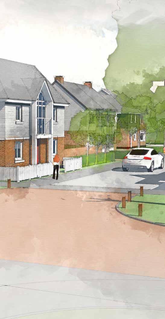
18 FIGURE 9. Vision for the Avenue Street within the site 18 LAND AT BERENGRAVE LANE, RAINHAM Design and Access Statement
19 04 EVALUATION AND RATIONALE Design team The aim of the applicant and design team is to create a proposal for the site which makes a positive contribution to the existing environment and in which future occupants are able to live, support and integrate into the existing community. To assist with the delivery of these aims, the following team of expert consultants contributed to the preparation of the proposals for this planning application: 3. Engaging The engagement took place with a number of key stakeholders including Medway Council and the local community with meetings and the distribution of a leaflet which set out the potential issues and concept plan for the site. Further details of this process are set out in Section 05 of this document. Strategic objectives natural area of play, new housing, the streets and public realm can improve the general quality of built form in the area and promote high quality development in the town as a whole. The new development can draw upon the character of landscape and built form within the town and wider Medway area. This will provide a rich palette of materials and design for the new neighbourhood. There are also opportunities to raise the quality of current development proposals through the detailed design and construction of the final scheme. Planning - Barton Willmore Urban Design and Architecture - Richards Urban Design Ltd. Transportation and access - i-transport Ecology - Ecology Partnership Drainage - Weetwood Landscape - The Environmental Dimension Partnership Heritage and Archaeology - Thames Valley Archaeological Services Developing a masterplan To achieve a successful masterplan we have sought to both understand the site, its constraints and opportunities and to also establish a strong vision using three key stages: 1. Understanding the site Technical studies have been undertaken to support the analysis of the site including a review of the ecology, the character of the area in built form and spaces, movement and access, hydrology and archaeology. Details of these are provided in Section 02 of this document and in separate reports submitted with the planning application. 2. Creating a vision The vision and strategic objectives which we have outlined for the site have been established from a balance of analysis, engagement and innovation. The vision is as follows: A new development with housing, public open space and landscaping which enhances the character this part of Rainham and provides a range of well designed housing to support a range of local needs. Building on the vision we identified a series of opportunities or strategic objectives which have guided the evolution of both the masterplan and will support the development of the new neighbourhood area. Retain the landscape character of the area The landscape structure of the site will seek to retain the existing well treed edge to the town and into the site. Buildings have been set back from the edges of the site to protect the existing landscape features. The existing public right of way has been retained along the northern eastern boundary set in a landscaped corridor and overlooked by new development to ensure passive surveillance where possible. Providing a mix of housing and open space opportunities which responds to local need Through the provision of new residential development there will be an opportunity to provide new homes for a range of local people including both privately owned and affordable housing including both socially rented and shared ownership properties. The development of the site will also bring forward areas of informal public open space including a children s play area for toddlers and young children. Creating buildings and spaces which respond to and reinforce the character of Rainham and the wider area The site provides the opportunity to create a place which responds positively to the character of Rainham and the wider parish. Well designed spaces such as the green edges and Provide housing which promotes sustainable living for existing and future residents Good pedestrian and cycle links will be provided outside of the site to connect to existing services and facilities in the local area. There are also opportunities for a range of passive sustainable features with the urban development areas including Sustainable Urban Drainage, grey water recycling and passive solar design. Enhancing the biodiversity on the site and creating new habitats There are a number of existing ecological features on the site and opportunities for their enhancement. These include the existing grassland and vegetation. These will be retained as existing with development set back and integrated into the public open space within the new neighbourhood. The areas of public open space and drainage basins will also create opportunities for the planting of new wild flowers and native species. Development concepts The masterplan which has been developed follows a pattern of site analysis and response. The diagrams on pages show the key elements of the design concepts. LAND AT BERENGRAVE LANE, RAINHAM Design and Access Statement 19
 Former archery range in the centre of the site Some mature trees with the majority of vegetation either self seeded or scrub The surrounding area")
20 1 2 3 The existing site The existing site comprises the following elements: Nursery and retail area at the front of the site Hardstanding car park area Vehicular access from Berengrave Lane Growing area in the rear of the site (currently not used) Former archery range in the centre of the site Some mature trees with the majority of vegetation either self seeded or scrub The surrounding area includes: Residential development to the south east and south west Bloors Community Woodland to the north west Train line to the south west with cricket club beyond There is a public right of way which runs through the site connecting Berengrave Lane to Bloors Lane Retaining the landscape and ecology features Arboricultural and landscape surveys were carried out to identify trees and areas of landscape merit Ecology surveys were carried out to identify any species and habitats which needed to be retained This led to: the retention of areas of planting and grassland on the edges if the site Retention of a small number of trees within the centre of the site Retention of some of the tree planting along the site frontage to Beregrave Lane An integrated connected landscape framework A landscape framework was then developed to include the following elements: A landscape strategy which establishes the character areas within the site working with both the built form and drainage strategies Areas of additional public open space around the edges of the site adjacent to the existing landscape / ecology features New feature trees within the site to enhance the landscape character and provide a strong landscape structure 2 new avenues of street trees to connect the existing vegetation on the edges of the site and highlight pedestrian routes to Bloors Woodland from Berengrave Lane and links to the existing public rights of way 20 LAND AT BERENGRAVE LANE, RAINHAM Design and Access Statement

21 4 5 6 A connected movement strategy A movement strategy was introduced with a permeable pattern of development including: Primary access from Berengrave Lane A hierarchy of streets and footpaths including both streets, shared surfaces and pedestrian routes Traffic calming features to manages vehicle speeds across the site Streets and routes which are overlooked by active frontages to make them safe and secure A responsive approach to density and built form A density approach was developed which provided a mix of medium to low density housing with: Medium density in the central parts of the site with houses and apartments (orange) Lower density housing on the edges of the site to allow for a greater mix of built form and landscape planting (yellow) Built form which limits the scale of development in the lower density areas to 2 storeys maximum. Potential for a small number of 3 storey buildings within the higher density areas within the central areas of the site Active frontages and key buildings to make it easier to move around The layout ensures that streets and spaces are faced by development to provide active frontages and safe and secure routes and spaces Locations for new key buildings are shown to provide landmarks within the development and make it easier to move around LAND AT BERENGRAVE LANE, RAINHAM Design and Access Statement 21

22 FIGURE 10. Leaflet distributed to over 1600 addresses in the local area 22 LAND AT BERENGRAVE LANE, RAINHAM Design and Access Statement
23 05 ENGAGEMENT Local Planning Authority The previous and current application have been subject of much discussion with the local planning authority including: A formal pre-application submission and meeting with the Local Planning Authority Detailed engagement with officers from the local and county council on matters such as highways, landscape, arboriculture, public open space and affordable housing In response to the comments made by officers at the preapplication meeting a number of changes have been made to the proposals including: Changes to the mix of affordable housing to replace apartments with houses Preparation of an integrated landscape and drainage strategy Extension of adoptable highway to accommodate turning heads where appropriate on the layout. Provision of 30 no. car parking spaces to meet the 0.25 spaces requirements of the Medway Parking Strategy (Adopted March 2010) Resizing of the garages to provide internal dimensions of 7m x 3m It is envisaged that further engagement will take place post submission to ensure that officers and members are well informed to make their final decision. Community engagement At the beginning of August 2017 as the scheme was emerging, Gleeson undertook a public consultation exercise in the form of a leaflet drop. A consultation leaflet was delivered to over 1600 householders in the local area. The Statement of Community Involvement which has been submitted as part of the planning application shows the extent of the leaflet distribution. The approach was taken to distribute leaflets rather than host an event as in previous similar applications a better and more detailed response can be achieved and documented through this approach. Contacts were provided on the leaflet to answer questions and discuss the proposals. The leaflet provided a concept masterplan for the site showing the principle design strategy and asked the following questions: Q1. Do you have any comments on the draft masterplan? Q2. What community facilities could we provide / enhance as part of our proposals for the benefit of local residents? Q3. Do you have any other comments? Responses to consultation comments A total of 1638 leaflets there was a total of 182 responses were received (11%). Based upon the feedback received, there were four main topics that were commonly raised by respondents, as follows: 1. Traffic and Access issues including perceived traffic capacity of the existing highway network, the potential impact from additional vehicles arising from the proposed development, the safety of the proposed access onto Berengrave Lane and parking 2. Capacity of local Infrastructure and Services including perceived capacity issues in terms of a shortfall of healthcare and school spaces 3. Layout and content of the Proposed Development 4. The Principle of Development The majority of responses to the Consultation Leaflet related to the perceived impacts of the development on the existing highway network, infrastructure and the current landscape. The applicant has actively sought to address these concerns and technical reports have been prepared to assess the existing position and test the likely impact of the proposed development. Where any detrimental impacts occur, mitigation measures or long-term management options have been put forward to ensure that there is a positive and ultimately a net gain to the local community and environment, both environmentally and socially. LAND AT BERENGRAVE LANE, RAINHAM Design and Access Statement 23

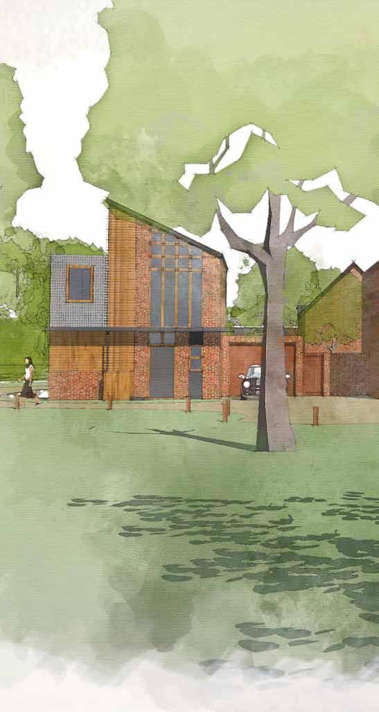
24 FIGURE 11. Vision for the Green Lanes on the edges of site 24 LAND AT BERENGRAVE LANE, RAINHAM Design and Access Statement
25 06 DESIGN AND ACCESS This section of the statement will explain and justify the proposed masterplan and layout for the site. The illustrative site layout plan is shown at Figure 12. and has been developed to satisfy the technical requirements of residential layout, access, ecology, landscape and hydrology in detail. The layout also follows the principles of good urban design practices as set out in various documents including By Design, Building for Life and the Urban Design Compendium. Amount The total area of the site measures 5.8 ha / 14.3 acres. The site layout plan shows the following elements: 121 new homes at a medium to low density (21 dph gross density) including mix of residential accommodation comprising 1,2,3 and 4 bedroom dwellings including a percentage of affordable housing. Circa 2.2 ha / 5.4 acres of public open space and landscape planting (approximately 38% of the total site area) including large areas of landscaped informal space on the edges of the site incorporating Sustainable Urban Drainage features and potential for a Local Area of Play in the north western part of the site. A vehicular access from Berengrave Lane in the approximate position of the existing nursery access to the site New planting on the boundaries and within the site to contain the development and safeguard the amenity of existing properties. Layout The illustrative layout (Figure 12.) has been prepared to demonstrate how the development could be laid out to respond to the opportunities of the site, taking into account the vision and the outcomes of the engagement. The layout is not for approval as part of the outline planning application but demonstrates the sites ability to deliver a scheme as described by the application. The layout shows the following key elements: Retention of important trees and hedgerows within the site and on its boundaries with enhanced landscape planting to reinforce the boundaries of the site. New soft landscape features within the development including a number of trees and hedgerows which will replicate the distinct character of the town edge. A new Sustainable Urban Drainage System (SUDS) which manages the surface water run-off within the site in the form of shallow sided detention basins and swales. A new vehicular access from Berengrave Lane Retention of existing public rights of way to provide pedestrian links through the site A hierarchy of streets, shared surfaces and footpaths which aim to reduce traffic speeds and encourage pedestrian / cycle priority in certain areas. The frontages of buildings lie parallel to the line of the street in order to reinforce the definition of the street with variety in set back, to replicate the character of streets within Rainham. Areas of public open space which can accommodate the strategic planting, SuDs features and potential for both a toddler and young children s play area with appropriate set backs from residential properties A pattern of built form which provides: Lower density housing on the fringes of the development in all areas, overlooking the public open spaces and providing a mix of planting, scale and massing to soften its appearance in the landscape. Medium density in the remaining parts of the site creating a logical block structure. Green buffers around the edges of the site boundaries to provide a set back from the existing edges of the site. This will provide space for additional planting which will soften the impact of the development. Predominantly two storey buildings with some three storey buildings and the potential for landmark buildings at key locations within the site to assist in providing legibility. Landmarks are provided by the arrangement of buildings and will use material and detailed design to enhance their legibility. The size and shape of plots varies from one plot to another. This means that detached, semi-detached and terraced housing are distributed throughout the site. Plots also vary in shape and size for each type of house. A variety of setbacks of houses from the pavement or highway between plots as one moves along a street. In other words there is a varied building line with a strong definition of the street maintained through boundary hedges and walls. In some cases the houses are set back quite far back on the plot whereas in other cases the house would be very close to the back of the footway or a shared surface. LAND AT BERENGRAVE LANE, RAINHAM Design and Access Statement 25

26 N Existing right of way retained Drainage area within new open space Existing planting retained with open space on the edges of the site Children s Play Area Proposed residential development Existing right of way retained Existing planting retained with open space on the edges of the site Existing Cricket Club BERENGRAVE LANE Proposed access FIGURE 12. Illustrative site layout plan 26 LAND AT BERENGRAVE LANE, RAINHAM Design and Access Statement
27 Detailed layout considerations Whilst siting is not for consideration as part of the outline application, an illustrative layout has been prepared to show that the site has capacity to accommodate the proposed quantum of development and the associated detailed design requirements. With regards the detailed layout of the individual dwellings and open spaces, the houses are generally arranged in a conventional block structure with gardens to gardens and many of the houses have a generous set back from the roads and shared surfaces. The layout of dwellings provides garden sizes which are generally between 10m and 15m which allow for adequate private amenity space. This reflects the character of existing development in the vicinity of the site and the need to maximise the effective use of the site for housing. The arrangement of buildings will ensure that all new dwellings will have a suitable outlook and level of natural light. Refuse collection arrangements will be considered at reserved matters stage. A statement of intent on this issue is provided later in this document. Mix of dwellings The mix of dwellings shown on the illustrative site layout plan includes a range of dwelling types and sizes for both private and affordable housing with a focus on a mix of smaller units and family housing. The overall mix of units shown on the illustrative layout plan is as follows: Unit type Approx size (sqm) No. units % 1 bed flat bed flat bed house bed house bed house Market housing The illustrative site layout plan shows a mix of housing sizes for the market element. The proposed mix of units includes a wide range of unit types and sizes including 2,3 and 4 bedroom houses. Affordable housing The site layout plan shows how the site could accommodate up to 25% affordable housing including a mix of units which responds to current housing need with a focus on smaller units. The proposed mix of units includes a wide range of unit types and sizes including and 1, 2 bedroom apartments with 3 and 4 bedroom houses. Unit type Approx size (sqm) No. units % 1 bedroom flat bedroom flat bedroom house bedroom house The affordable units all comply with the minimum space standards as set out in the Department for Communities and Local Government Technical housing standards nationally described space standard (March 2015). Unit type Approx size (sqm) No. units % 2 bed house bed house bed house LAND AT BERENGRAVE LANE, RAINHAM Design and Access Statement 27
28 N The illustrative site layout plan shows how the affordable housing could be distributed within the scheme at Figure 13. This approach shows the affordable units integrated within the private housing, but focussed in clusters to assist in their procurement and future management. The affordable units would be tenure blind i.e. no discernible difference between the private and affordable units KEY Potential location of affordable housing unit FIGURE 13. Plan showing the potential distribution of affordable housing units 28 LAND AT BERENGRAVE LANE, RAINHAM Design and Access Statement
29 Use N The development provides a mix of residential uses and open spaces which are in keeping with the character of the surrounding area. Figure 14. shows the proposed land use pattern for the site which includes the following uses: Existing residential development Existing woodland Existing recreation use Proposed lower density housing areas Proposed medium density housing areas Proposed areas of informal public open space / landscape planting Potential location for natural play area (LAP) The land use pattern has been established to address the following: Provide reduced density on the edges of the site to respond to the soften the edges of the urban area and respond to the existing landscape and ecological assets of the site Provide a softer urban edge on the south eastern boundary with lower density development set back into the site. This will help retain the character of this part of Berengrave Lane and ensure the retention and protection of the trees. Provide medium density development in the more central parts of the site which are less visually prominent and well screened by existing trees and hedgerows and the lower density housing on the edges FIGURE 14. Land use plan LAND AT BERENGRAVE LANE, RAINHAM Design and Access Statement 29

30 N Scale and massing The scale and massing of the proposed development would be designed to respond to the site characteristics and to create a variety in the built form, typical of Rainham. Buildings shown are predominantly rectangular or L shaped with occasional articulation in the form of projections and porches. A range of detached (large and small), semi-detached and short terraces would be provided across the site. The proposed housing development shown would be predominantly two storeys with some three storey buildings in key locations as indicated on Figure storey development 2 storey development 3 storey development FIGURE 15. Scale and massing plan 30 LAND AT BERENGRAVE LANE, RAINHAM Design and Access Statement
31 Character The character will be defined by both the spatial arrangement of areas and the characteristics of the streets and spaces within these areas. N There are principally three different kinds of urban streets / areas. Their characteristics assist in both defining the hierarchy of the streets, legibility and movement within the development and the relationship of built form, streets and spaces within the site. Within the development, potential locations have also been shown for key buildings which will assist in the legibility of the place and creating views and landmarks within the scheme. The character of the areas, streets and key buildings are shown on Figure 19. as follows: Avenue street Residential Streets * Green Drives Key building location FIGURE 16. Character areas and key buildings LAND AT BERENGRAVE LANE, RAINHAM Design and Access Statement 31


32 Avenue street The illustrative site layout plan shows the primary residential street within the centre of the housing area which provides the main route into the site and provides the link to other secondary streets and lanes. The character of the Avenue street can be defined by the following features: 1 A road width of 5.5m with 2m footways on either side either adjacent to the carriageway or set back behind verges. The carriageway material will differ from the residential streets and encourage slower speeds 2 Buildings overlooking the street set back from the street with medium front gardens. 3 Built form in a variety of arrangements including detached, semi detached and small terraces or groups of buildings. 4 Front gardens defined by walls, timber fences, hedgerows 5 Buildings of both 2 and 3 storeys in height Car parking will be provided on plot with direct access to the street or in defined bays within the street. 6 7 Large trees provided on at least on side of the street 2-4m 2m 5.5m 2m 2-4m Private realm Public realm FIGURE 17. Typical section through the Avenue Street Private realm FIGURE 18. Illustration showing the character of development in the Avenue Street character area 32 LAND AT BERENGRAVE LANE, RAINHAM Design and Access Statement


33 Residential Street The illustrative site layout plan shows a residential street within the centre of the housing area. The character of the residential street can be defined by the following features: 1 A road width of 5.5m with 2m footways on either side 2 Buildings overlooking the street set back from the street with medium to short front gardens. These vary in depth to match the character of set backs in Rainham. Built form in a variety of arrangements including detached, semi detached and small terraces or groups of buildings. 3 4 Front gardens defined by walls, timber fences, hedgerows 5 Buildings of both 2 and 3 storeys in height Car parking will be provided on plot with direct access to the street or in defined bays within the street m 2m 5.5m 2m 2-4m Private realm Public realm FIGURE 19. Typical section through the Residential Street Private realm FIGURE 20. Illustration showing the character of development in the Residential Street character area LAND AT BERENGRAVE LANE, RAINHAM Design and Access Statement 33


34 Green Drives The illustrative site layout plan shows a series of Green Drives which define the edges of the residential development area and areas where the urban form adjoins areas of public open space and the edges of the site. Their character responds to relationship between the informal open space and built form and to the potential for views into the site from Berengrave Lane from the public right of way. The built form and massing has been broken down into predominantly detached buildings. Planting is provided between buildings and in front of the properties to provide a transition with the open space and urban edge. The buildings front onto a shared surface which provides limited access for vehicles and controls speeds through its width and alignment. Lighting will also be reduced in these parts of the site. 2-4m 4.8m The existing and proposed hedgerows and trees on the edges of the site will be retained and supplemented to set the development into a treed structure. Private realm FIGURE 21. Typical section through the Green Drive Public realm The character of the Green Drives can be defined by the following features: 1 A road width which varies providing a shared surface for vehicles, cyclists and pedestrians 2 Buildings overlooking the street set back from the street with short to medium length front gardens 3 Built form predominantly in detached form with some clusters of houses 4 Front gardens defined by low walls, timber fences or hedgerows / shrub planting 5 Buildings a maximum of 2 storey in height with potential for 3 storeys buildings in key locations 6 Car parking will be provided on plot with direct access to the shared surface. Visitor parking will be provided in identified bays parallel to the carriageway. FIGURE 22. Illustration showing the character of development in the Green Drives character areas 34 LAND AT BERENGRAVE LANE, RAINHAM Design and Access Statement


(b)(c) generally have simple or open eaves detailing with opportunities for decorative facias on key")


35 Appearance and materials The proposed application is in outline form and appearance and materials will be subject to future reserved matters applications. The approach to the design and appearance of the buildings and spaces draws heavily on the existing character of Rainham and the wider Medway area. A blend of traditional and contemporary approach has been shown in this document there is scope for interpretation of the design features with a stronger bias towards either traditional or contemporary design. The aim is to achieve a design standard which raises the quality for the area. It is envisaged that the development will utilise a fairly limited palette of materials relying more on architectural detailing and design to promote identity than material. This is more in keeping with the traditional approach to building utilising locally sourced materials where possible. Whilst built form within the site should have unity in materials and design principles, a standard approach to the design of dwellings should be avoided where possible. The palette of materials should reflect the local vernacular responding positively to the character of the area. The use of material and level of detailing should reflect the character of the area and the function of the buildings. All materials will need to be agreed with the Local Planning Authority in advance of development. Some of the key design features which could be incorporated within the development include: Elevations Elevations will be generally flat with some projecting bays at ground floor or two storey projecting gables. a Porches are generally projecting features either stand alone or integrated into bays or gables. The proposed elevations include use of the following materials: Red brick (a) Painted render (b) Horizontal timber boarding (c) Roofs Roof pitches may vary according to design and material. Roofs and eaves within the development should: b be clay or grey slate colour with plain tiles (a)(b)(c) generally have simple or open eaves detailing with opportunities for decorative facias on key buildings (b)(c) soffits and facias where provided should be either black or white (b)(c) b Windows The appearance of windows is determined by their siting, size, style and by the design of elements, for example, the sill, frame, transom, mullion, glazing bars and leaded lights. The design of each individual part can materially affect the overall proportions and appearance of the window, leading to an alteration in the appearance of the property. In proportion the windows and their design should respond to the rhythm of the elevation with either the horizontal or vertical emphasis. Windows within the development should: Be recessed from the elevation of the building (a)(b)(c) Where obscure glazed, not be on the front elevation of the building Predominantly white frames (not dark stained hard wood) (b) Include sills and lintels or brick headers / surrounds (a)(b)(c) a Doors b As with windows there is a clear role for modern materials and design solutions but their use requires careful consideration. Doors within the development should where possible have the following characteristics: c a b c Where possible, front doors should utilise natural timber as opposed to UPVC or metal Where they are painted to be predominantly black or white with some other primary colours Have a natural or white painted frames (not dark stained hard wood) Be recessed from the main elevation and avoid steps up, providing level access LAND AT BERENGRAVE LANE, RAINHAM Design and Access Statement 35


 Ecological mitigation to be located on site by ecologist Reptile Hibernacular/ refugia, comprising")
 *All planting to comprise native species of local provenance with species as recommended by the PEA,")


 5 drawing title Plan EDP 7: Landscape and Ecology Strategy Bat boxes - hung on mature trees or buildings")

36 Site Boundary Existing woodland to be retained and managed to enhance species richness and diversity, and woodland edge planting* Existing trees and shrubs retained Existing hedge retained and managed at a minimum of 3m tall and 4m wide (1/5 of the hedge cut in any one year) Street hierachy has been reinforced through landscape features. Large specimen trees run along the wide main route through the development. Secondary streets are more enclosed and informal lined by smaller trees. Tertiary streets are more informal and typically overlook public open space. Proposed large and feature trees* Proposed trees and shrubs* Proposed native hedge* 4 LEAP with timber equipment, and natural play features, to complement the edge of settlement wooded character. 2 Proposed species enriched long grass - cut on a 1 or 2 year rota to a minimum of 150mm and enrich with species as recommended by the PEA for Turtle Dove foraging. Proposed mown grass SuDS storage basins wet during flood conditions Main street with formal, large tree planting Secondary Streets with informal, medium sized, tree planting Shared surface streets Footpaths 5 3 Public Right of Way Attenuation basins feature throughout the scheme to alleviate surface water and provide ecological opportunities and amenity value. 4 1 Play Area Note Mitigation measures to be read in conjunction with the Preliminary Ecology Appraisal (PEA) Ecological mitigation to be located on site by ecologist Reptile Hibernacular/ refugia, comprising log piles (5.no.) *All planting to comprise native species of local provenance with species as recommended by the PEA, wherever appropriate. Closer to properties, where space is more restricted, exotic species of value to wildlife to be used. client Gleeson Strategic Land Areas of open ground with weed seeds for reptile basking and Turtle Dove foraging project title Bird boxes sparrow boxes integral with buildings (10 no.) Rainham, Bird boxes various throughout woodland and buildings (18no.) 5 drawing title Plan EDP 7: Landscape and Ecology Strategy Bat boxes - hung on mature trees or buildings around the site Stag beetle areas existing dead wood and surrounding area to be left undisturbed wherever possible and supplemented with log piles that are allowed to rot. date drawing number scale 11 SEPTEMBER 2017 EDP3943/08 Refer to scale bar drawn by checked QA AL TR JTF Approximate location of badger set 20m buffer to construction works The Environmental Dimension Partnership Ltd. Crown copyright and database rights 2017 Ordnance Survey m info@edp-uk.co.uk Cirencester Cardiff Shrewsbury LAND AT BERENGRAVE LANE, RAINHAM Design and Access Statement FIGURE 23. Landscape strategy plan (Prepared by EDP)


37 Landscape The site layout has been designed to integrate with its context by reflecting the regular building lines and generally straight roads of the predominantly 20th century housing across this area of Rainham. It also responds to adjacent areas of native vegetation, on and off site, through the use of a more sinuous, softer, edge treatments. The layout also promotes visual integration through the retention of substantial areas of existing vegetation, primarily along the site boundaries, where it is most apparent from the surrounding area. The vegetation shown as retained on the layout comprises the key assets, in terms of the landscape, arboricultural, and ecological considerations, so limiting the potential impact on these assets. In addition, the layout shows how this retained vegetation could form an integral part of the public open space across the site so maximising their visual and recreational value. The proposed landscape strategy reinforces this design approach, and builds on it, with a green infrastructure that is multi-functional and provides connections across the site and to the site context. Within the site the strategy shown how the legibility of the street hierarchy could be enhanced through tree planting, with large formally arranged trees along the primary route and smaller, informally arranged, species along secondary routes. The softer development edges could include retained and augmented existing ecological, arboricultural and landscape features, to contribute to visual, wildlife and recreational amenity, through the inclusion of: sinuous paths that provide destination and recreational routes linking across the site and to the existing PRoW and road network; SuDS features designed with naturalistic flowing lines and areas of permanent marsh; areas of species enriched grassland, adjacent to existing woodland, and mown grass across more open areas; new, appropriate, tree and shrub planting including native species, where space allows, and smaller species that have wildlife value were space is more restricted; a naturalistic play area and natural areas for informal recreation that benefit from informal surveillance. The layout and landscape strategy show how the site could be developed for housing in a way that integrates with the site context and retains key landscape, ecological, and arboricultural assets. More than this, it shows how it could provide new areas of attractive public open space the delivery and maintenance of which could be secured through condition. LAND AT BERENGRAVE LANE, RAINHAM Design and Access Statement 37

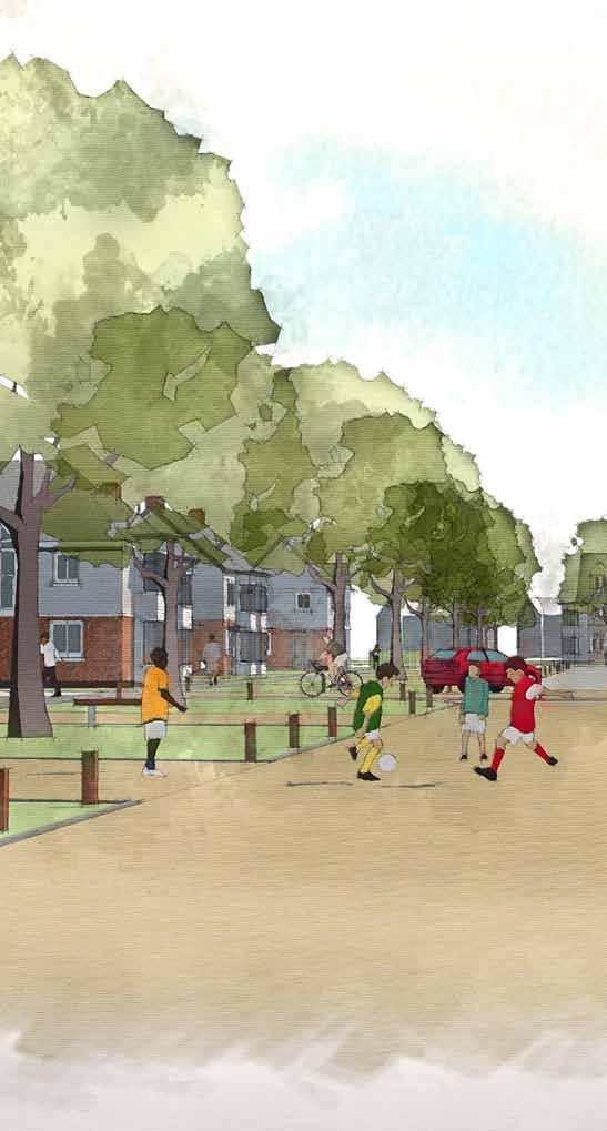
38 FIGURE 24. Vision for the residential streets within the site 38 LAND AT BERENGRAVE LANE, RAINHAM Design and Access Statement
39 Access The movement and access strategy has been designed to provide a permeable layout which supports ease and safety of movement for all users. The layout and design of spaces and buildings takes into account the needs for both vehicular and transport links, and inclusive access. N Figure 25. shows the movement framework, based on a hierarchy of streets and routes for vehicles, cyclists and pedestrians with the subsidiary streets being narrower than the main street within the development. Vehicular and transport access Access to the site will be formed via a simple priority T junction on Berengrave Lane in the vicinity of the existing site access to the Berengrave Nursery. The proposed access arrangement is shown on Figure 26. The site access will comprise a 5.5m carriageway width with 2m wide footways to either side to tie in with the existing footway north of the site access. An uncontrolled pedestrian crossing will be installed in the vicinity of the site access. Visibility will be provided at 2.4m x 43m commensurate with the 30mph speed limit on Berengrave Lane in the vicinity of the site access. The layout will be designed in line with key guidance contained within the DfT s Manual for Streets and Manual for Streets 2. The internal road layout has been designed to an adoptable standard. KEY Residential Street (5.5m) Shared surface (4.8m minimum) Existing Public Right of Way (PRW) New pedestrian footways within the site Potential future link to Community Woodland subject to agreement FIGURE 25. Movement and access strategy LAND AT BERENGRAVE LANE, RAINHAM Design and Access Statement 39
40 N M1 M1A EXISTING ACCESS POINT RETAINED FOR ADJACENT PROPERTY M3 M1C M1B 5.5m M2 2.0m FOOTWAY LOCATION OF PROPOSED PEDESTRIAN CROSSING DR1 M22 2.4m x TANGENTIAL VISIBILITY SPLAY DT1 2.4m x 47m VISIBILITY SPLAY (TO 0.5m OFFSET) DT2 M21 DR2 ITL Land at Berengrave Lane, Rainham, Kent\Tech\Acad\i-Transport Drawings\Working Drawings\GA\ITB12519-GA-001 Rev C.dwg KEY: FIGURE 26. Plan showing the main access to the site from Berengrave Lane via a simple priority junction HIGHWAY BOUNDARY 2.4m x 47m VISIBILITY SPLAY (TO 0.5m OFFSET) REPRODUCED FROM THE ORDNANCE SURVEY DRAWING ISSUED FOR FEASIBILITY CONSIDERATION AND PLANNING PURPOSES ONLY. DRAWING MAP WITH THE PERMISSION OF THE NOT TO BE USED FOR CONSTRUCTION. I-TRANSPORT LLP ACCEPT NO RESPONSIBILITY FOR CONTROLLER OF HER MAJESTY'S STATIONERY ERRORS MADE BY OTHERS IN SCALING FROM THIS DRAWING. MEASUREMENTS SHOULD BE SCALE 1:500 OFFICE. 40 LAND LICENCE AT No. BERENGRAVE LANE, RAINHAM TAKEN FROM FIGURED Design DIMENSIONS and Access ONLY. Statement CDM REQUIREMENTS CONSIDERED AT FEASIBILITY CROWN COPYRIGHT RESERVED. STAGE ONLY. FURTHER CONSIDERATION REQUIRED BY DETAILED DESIGN TEAM
41 The following principles will be applied in developing the layout: Primary Street 5.5m carriageway with 2m footways; Private Driveways narrower shared surface areas where refuse vehicles do not need to enter; Service margins provided where no footway is present; and A 20mph design speed will be adopted on primary streets. Pedestrian and Cyclist Access Footways will be provided on one side of the proposed access leading into the site. The main residential road which will have 2 x 2m footways along its length. In order to maximise the permeability of the site and promote travel by means other than the car, pedestrian links will be provided to connect to the existing public rights of way which runs through the north eastern part of the site. There is also potential for a new pedestrian link into Bloors Community Woodland, subject to agreement with the Woodland Trust. Public Transport The closest bus stops to the site are located on Childscroft Road, approximately 250m to the east of the centre of the site. Existing bus services provide opportunities to travel to key destinations such as Chatham, Darland, Hamspted Valley, Sittingbourne, Gillingham and London without reliance on the private car. The A2 London Road corridor provides frequent bus services providing a very real alternative to private car use. Rainham Railway Station is located some 1.05km from the centre of the site and is accessed by walking or cycle. This station has access to 233 car park spaces, 4 accessible spaces and 64 cycle storage spaces. There are direct services from Rainham Railway Station, including their typical frequency and journey time during both peak and off-peak periods. Destinations accessible by rail include Gillingham, Sittingbourne, Ramsgate, London, Faversham and Dover. Regular services to London Victoria and London St Pancras. The journey time is approximately 1hr. A bus route runs along Berengrave Lane, with bus stops on Childscroft Road close to the site. The Nuventure 130 and 131 service operate on this route which runs between Gillingham and Maidstone. Parking Car and Cycle parking will be provided in accordance with Medway Council Residential Parking Standards (March 2010). Number of bedrooms Min Car Parking Requirement Min Cycle Parking Requirement 1 bedroom 1.0 spaces 1.0 space 2 bedrooms 1.5 spaces 1.0 space 3 or more bedrooms Visitor parking 2.0 spaces 1.0 space 0.25 spaces Where spaces are given as whole numbers and decimals, the whole numbers have been allocated for individual units and the decimals for visitor parking. The principal design considerations for car parking is as follows: All homes to be provided with allocated car parking spaces Dimensions of parking spaces and garages to be provided in accordance with guidance Parking to be provided within curtilage of individual dwellings and within communal parking areas for apartments Well-designed on-street visitor parking in dedicated laybys will be provided and dispersed throughout the site For most car parking situations parking spaces will meet the national standards of 4.8m long by 2.4m wide. This is considered generally adequate. However, where a space is located in front of a garage, the space will be 5.5m long from the back of the highway to allow the garage door to be opened without the vehicle overhanging the highway. Garages are 7m long by 3m wide internally to allow a vehicle to gain access/egress and there to be some space for the occupiers of the vehicle to get out. In addition, this provides some space for storage, such as bicycles, which are normally kept in garages. As with all parking on the site, there are not more than one space outside a garage. Cycle parking for the proposed houses will be provided in garages and in sheds in back gardens and in secure buildings and communal areas for apartments to meet the required standards. The table below shows the requirement and provison of car parking spaces for the proposed development. Beds Units Spaces required Total spaces Spaces Total spaces visitor parking spaces have been shown on the site in dedicated bays off the main carriage ways and do not interfere with service / emergency vehicles. In summary the development shows a minimum of 262 allocated spaces + 30 visitor spaces. This provides an average of 2.4 spaces per dwelling across the site. The requirement would be 2 spaces per dwelling using the adopted standards. Refuse collection The illustrative site layout has been designed to accommodate refuse vehicles. Street widths will provide for refuse collection vehicles and are sufficiently wide that cars parked on-street can be passed by the refuse vehicle. The illustrative layout will comply with the following criteria that are set on the Manual for Streets and based on Building Regulations and British Standards: 30m maximum distance from each dwelling to the bin collection point; 25m maximum distance from the back of the refuse vehicle to the bin collection point (for two wheel bins; 10m for four wheel bins for any apartment blocks); and Maximum of three steps for containers up to 250 litres (e.g. two wheel domestic bin), and none for larger containers. Swept path analysis of the proposed access has be undertaken to confirm the final design, and this will assess the ability of large refuse vehicles, a fire tender and a large car to access the site safely. LAND AT BERENGRAVE LANE, RAINHAM Design and Access Statement 41

 consisting of permeable paving, swales and detention basins.")
42 Drainage Surface Water Drainage Strategy The proposed drainage strategy is shown at Figure 27. and includes a number of sustainable urban drainage systems including: Permeable surfaces with cellular attenuation Open balancing features Roadside swales F S Proposed foul sewer Proposed foul water manhole Proposed surface water sewer Proposed surface water manhole Proposed infiltration basin The surface water drainage strategy proposals are for development runoff to discharge to the watercourses within the site via a series of Sustainable Drainage Systems (SuDS) consisting of permeable paving, swales and detention basins. Discharging surface water runoff via the SuDS devices will afford some improvement in water quality whilst allowing the post development flows to be restricted to the 1 year greenfield runoff rate. All SuDS features will be designed in accordance with best practice (National Policy, EA and CIRIA guidance) and cater for the 1 in 100 year flood event plus 30% to allow for the predicted impacts of climate change over the lifetime of the development. Therefore the development will not increase flood risk to existing development off site for flood events up to an including the 1 in 100 year plus 30% climate change. Foul Water Drainage The foul water drainage strategy proposals are for foul water flows from the development to connect into the existing mains network under the provisions of the Water Industry Act N FIGURE 27. Plan showing Sustainable Urban Drainage Strategy for the site 42 LAND AT BERENGRAVE LANE, RAINHAM Design and Access Statement

43 Sustainability Sustainability targets and objectives have been set for the proposed development based on the applicant s aspirations and a review of government guidance, the latter of which has recently embedded energy efficiency targets within Building Regulations in lieu of the Code for Sustainable Homes. The applicants are committed to ensuring the proposed development meets national requirements for energy efficiency prevailing at the construction stage. Retention of existing trees and landscape features away from built form Building design to meet minimum requirements for building regulations Potential for rain water harvesting Potential for photovoltaic and solar water heating panels on south facing roof pitch Car parking set back behind building line Key sustainability features would include the following: Sustainable Urban Drainage Systems (SUDS) would be incorporated. Energy and water efficient fixtures and fittings would be incorporated within the design of new buildings. New planting to enhance biodiversity Provision would be made for cycle storage and safe walking routes to discourage the use of private cars for short journeys. Consideration would be given to responsible sourcing of materials and to their environmental impact throughout their lifecycle. Recycling space and composting would be provided for each dwelling. Private gardens, communal spaces and publicly accessible open spaces would be incorporated into the development, including informal open space and children s play areas. Buildings to be orientated to maximise passive solar gain Existing trees and hedgerows would be retained and the ecology of the site enhanced through the creation of new wildlife habitats. Overall, and whilst further detailed calculations and design work will continue as the development progresses, the proposals for the site aim to maximise the site s assets and layout in relation to sustainable design, creating an attractive, environmentally sound, development. Drive widths to allow for both parking and access for bicycles and bins Area for growing food Provision of areas for bin storage and composting facilities Storage building for cycles which is easily accessible and secure FIGURE 28. Plan showing Sustainable Design concepts LAND AT BERENGRAVE LANE, RAINHAM Design and Access Statement 43


 to these routes.")

44 Secured By Design The proposals have been designed to be as safe and crime free as possible and in particular has had regard to the following guidance: Safer Places the Planning System and Crime Prevention Principles of Secured by Design. Seven attributes of designing out crime are outlined in Safer Places The Planning System and Crime Prevention. They are listed here, with an explanation of how the development addresses the points: 1. Access and movement Places with well defined routes, spaces and entrances that provide for convenient movement without compromising security. The layout provides a legible and permeable series of connected routes. These are overlooked and buildings are arranged to either front onto or have side aspect (with habitable rooms and windows) to these routes. Ground floor entrances are positioned for ease of access and will be clearly articulated in detail. 2. Structure Places that are laid out so that crime is discouraged and different uses do not cause conflict. A perimeter block structure is proposed for the development that enables all dwellings to face out and overlook the streets and spaces. Private and public domains are well defined by boundary treatments and clear definition of spaces. 3. Surveillance Places where all publicly accessible spaces are overlooked. Configuration of dwellings and public realm has been designed to avoid confined and secluded spaces. Streets and spaces are open and have clear sight lines allowing easy monitoring and natural surveillance. All public open spaces are overlooked by development. Dwellings on corners of streets and green lanes, or with a side elevation facing open spaces will have windows and other elevation features to ensure there are not any blank facades facing onto the public realm. 4. Ownership Places that promote a sense of ownership, respect, territorial responsibility and community. The layout makes clear distinction between private and public spaces. The main public open space elements in the western parts of the site and within the centre of the development have been designed as a focus of the development with many buildings looking into the space. There are also a number of opportunities for the use of this space for all aspects of the community including children s play, informal play and places to rest. 5. Physical protection Places that include necessary, well designed security features. Physical protection measures will be incorporated into the scheme through the detailed design development. 6. Activity Places where the level of human activity is appropriate to the location and creates a reduced risk of crime and sense of safety at all times. Streets and spaces will be of high quality and have been designed with the aim of attracting activity in the form of recreation, social interaction and play which will help provide security. 7. Management and maintenance Places that are designed with management and maintenance in mind, to discourage crime in the present and the future. Management strategies and solutions specific to these proposals will be developed at a later detailed stage. 44 LAND AT BERENGRAVE LANE, RAINHAM Design and Access Statement
45 N KEY Perimeter block structure Active frontages overlooking streets and spaces Key pedestrian routes overlooked Open spaces overlooked Natural play area overlooked FIGURE 29. Plan showing how the principles of Secured by Design have been applied to the layout LAND AT BERENGRAVE LANE, RAINHAM Design and Access Statement 45


46 Building for Life Building for Life is the industry standard, endorsed by Government, for well designed homes and neighbourhoods that local communities, local authorities and developers are invited to use to stimulate conversations about creating good places to live. The existing public right of way which runs through the site has been retained and incorporated into the design. The land uses and layout respect the character and layout of the surrounding development and new buildings have been orientated and set back to respect their amenity where appropriate. The proposed development provides new landscape planting on the edges of the site to protect the amenity of existing residential properties. Building for Life is run by a partnership of Cabe at the Design Council, the Home Builders Federation and Design for Homes. This third edition of the guide was published in January 2015 by Nottingham Trent University on behalf of the Building for Life partnership (Design Council Cabe, the Home Builders Federation and Design for Homes. The updated version is based upon the new National Planning Policy Framework and the Government s commitment to build more homes, better homes and involve local communities in planning. The proposed development addresses all of the 12 criteria set out in the Building for Life. A table showing how each of the criteria will be met is shown at Figure 36 and explained in more detail below. 1. Connections Does the scheme integrate into its surroundings by reinforcing existing connections and creating new ones; whilst also respecting existing buildings and land uses along the boundaries of the development site? The layout has been designed to connect to the existing area via a the new vehicular access to Berengrave Lane. 2. Facilities and services Does the development provide (or is it close to) community facilities, such as shops, schools, workplaces, parks, play areas, pubs or cafes? The site is in a town setting, with access to local facilities and services including a public house at Lower Rainham, Rainham Cricket Club and Rainham Town Centre is approximately 5-10 mins walk from the site providing a range of facilities and services. There are also a number of focal places within the site which could be used as meeting places or places for interaction including the open spaces at the eastern end of the site, the entrance of the site and potential new children s play area. 3. Public transport Does the scheme have good access to public transport to help reduce car dependency? The closest bus stops to the site are located on Childscroft Road, approximately 250m to the east of the centre of the site. Existing bus services provide opportunities to travel to key destinations such as Chatham, Darland, Hamspted Valley, Sittingbourne, Gillingham and London without reliance on the private car. The A2 London Road corridor provides frequent bus services providing a very real alternative to private car use. Rainham Railway Station is located some 1.05km from the centre of the site and is accessed by walking or cycle. Destinations accessible by rail include Gillingham, Sittingbourne, Ramsgate, London, Faversham and Dover. Regular services to London Victoria and London St Pancras. 4. Meeting local housing requirements Does the development have a mix of housing types and tenures that suit local requirements? The scheme includes a good mix of dwelling types and tenures including up to 25% affordable homes. The mix includes a small number of apartments, starter homes and larger family homes. The mix of affordable housing has been developed in specific response to local housing need in consultation with the Council. The scheme has been designed to provide a tenure blind approach so that it is not easy to differentiate between homes that are private and those that are rented or in shared ownership. 46 LAND AT BERENGRAVE LANE, RAINHAM Design and Access Statement

47 5. Character Does the scheme create a place with a locally inspired or otherwise distinctive character? The scheme has been designed to reflect the character of the local and wider area. Details of the approach are set out in section 2,4 and 5 of this document. Further reinforcement of the character can be achieved at the reserved matters stage through the design of individual buildings. 7. Creating well defined streets and spaces Are buildings designed and positioned with landscaping to define and enhance streets and spaces and are buildings designed to turn street corners well? The layout follows a traditional perimeter block approach with private gardens backing on to each other and dwellings fronting and enclosing the streets or pedestrian / cycle connections. The layout uses a number of buildings which turn the corner and provide surveillance over two aspects as shown in Figure 33. All fronts of buildings face the street or public realm. 8. Easy to find your way around Is the development designed to make it easy to find your way around? The layout has been designed to allow people to create a mental map of the place by incorporating features that people will notice and remember. The layout follows a logical pattern of development using a hierarchy of streets and spaces which are permeable and allow people to find and navigate their way around easily. Landmark buildings and views though the site make it easy for people to see in advance where they are going. Habitable rooms with windows overlooking the street on ground and first floor Habitable rooms with windows overlooking the street on ground and first floor 6. Working with the site and it s context Does the scheme take advantage of existing topography, landscape features (including water courses), trees and plants, wildlife habitats, existing buildings, site orientation and microclimate? Car parking behind the building line to not visually dominate the street scene The scheme has been designed to respond to the character of the site with the arrangement of dwellings and intensity of development with areas of medium and lower density character within the layout. Dwellings in the eastern edges of the site have been set back from the boundary to provide a softer landscaped edge in this area. The existing hedgerows and large trees within the site have been retained and incorporated into the layout. A large number of the buildings within the layout have been orientated to optimise the solar potential of the site by their orientation to south. Managed hedgerow to allow for surveillance over Architectural design feature to turn corner FIGURE 33. Illustration showing how buildings will turn corners Low walls and railings to allow for surveillance over LAND AT BERENGRAVE LANE, RAINHAM Design and Access Statement 47


48 9. Streets for all Are streets designed in a way that encourage low vehicle speeds and allow them to function as social spaces? The layout of streets has been designed to reduce traffic speeds. There are no long stretches of wide road and the Green Drives and Avenue Streets will be shared surfaces. These are usually demarcated by a change of surface treatment which brings the attention of drivers to a change of environment and the need to slow down. This design approach thus gives priority to people over cars. The shared surfaces also provide social spaces and together with the informal public open spaces in this area can be used for safe children s play. 10. Car parking Is resident and visitor parking sufficient and well integrated so that it does not dominate the street? Car parking is a reserved matter and will be provided to meet the required standards of the highway authority. There area number of unallocated parking spaces spread across the site for visitors. 11. Public & private spaces Will public and private spaces be clearly defined and designed to have appropriate access and be able to be well managed and safe in use? Due to the scale of the development it is considered only appropriate to provide informal recreation incorporating a potential new children s play area. Contributions will be made to ensure that existing facilities for formal recreation and play will be achieved. Public and private spaces are well defined with all public spaces overlooked by neighbouring properties and located where they are accessible to a wide range of people including the new and existing residents. 12. External storage and amenity space Is there adequate external storage space for bins and recycling, as well as vehicles and cycles? Each of the properties has a private garden area which allows for sufficient space for the storage of bins and cycles. The majority of dwellings have a separate rear access to avoid having to go through the property for cycle storage. Parking is located close to people s homes, generally on plot. Garages and car parking spaces are provided set back between buildings so they do not dominate the street scene. All garages shown are detached from the dwelling so they are not easily converted to form additional living accommodation reducing the car parking provision. 48 LAND AT BERENGRAVE LANE, RAINHAM Design and Access Statement
49 Design element Requirement Response Red Green Integrating into the neighbourhood Connections Does the scheme integrate into its surroundings by reinforcing existing connections and creating new ones, while also respecting existing buildings and land uses around the development site? Yes. The masterplan responds to both the site and the surrounding buildings and land uses. The layout makes connections to the wider area and integrates the development to the surrounding area, providing new links through the site which will improve accessibility to public open space and play facilities. R Facilities and services Does the development provide (or is it close to) community facilities, such as shops,schools, workplaces, parks, play areas, pubs or cafes? Yes the new development is well located to existing facilities in the centre of the town and within Rainham as a whole. R R R Public transport Does the scheme have good access to public transport to help reduce car dependency? Yes. The site is well served by public transport with regular bus services along Berengrave Lane and Childscroft Road within easy walking distance of the site. Rainham Station is also within walking distance of the site. Meeting local housing requirements Does the development have a mix of housing types and tenures that suit local requirements? Yes, the scheme provides a mix of market and affordable housing including a wide range of dwelling types which have been discussed with the LPA as part of the application. Creating a place Character Does the scheme create a place with a locally inspired or otherwise distinctive character? The scheme is in outline form at this stage but the illustrative site layout and information within the Design and Access Statement demonstrates a high quality, contextual approach to the new development. R Working with the site and its context Does the scheme take advantage of existing topography, landscape features (including water courses), trees and plants, wildlife habitats, existing buildings, site orientation and microclimate? Yes, the layout retains all key landscape features including habitat areas, trees and hedgerows which will be enhanced through implementation of long-term management and complementary planting. R Creating well defined streets and spaces Are buildings designed and positioned with landscaping to define and enhance streets and spaces and are buildings designed to turn street corners well? Yes, the illustrative layout and Design and Access Statement show how this can be achieved within the site. R R Easy to find your way around Is the development designed to make it easy to find your way around? Yes, the illustrative layout and Design and Access Statement show how this can be achieved within the site including the provision of key buildings within the layout. Street & Home Streets for all Are streets designed in a way that encourage low vehicle speeds and allow them to function as social spaces? Yes, the illustrative layout shows a hierarchy of streets including roads and shared surfaces to ensure that people will have priority over cars. R R R Car parking Is resident and visitor parking sufficient and well integrated so that it does not dominate the street? Yes, the illustrative layout plan shows how sufficient car parking will be provided on the site including both allocated and unallocated parking spaces. Public and private spaces Will public and private spaces be clearly defined and designed to have appropriate access and be able to be well managed and safe in use? Yes, the block structure shown in the illustrative layout shows a clear definition of fronts and backs with private and public spaces defined. The detailed design of these areas will ensure that they are attractive, well managed and safe. FIGURE 30. Preliminary Building for Life Assessment LAND AT BERENGRAVE LANE, RAINHAM Design and Access Statement 49


50 50 LAND AT BERENGRAVE LANE, RAINHAM Design and Access Statement
BERENGRAVE NURSERY, RAINHAM. Planning Statement. Submitted on behalf of Gleeson Strategic Land
 BERENGRAVE NURSERY, RAINHAM Planning Statement Submitted on behalf of Gleeson Strategic Land October 2017 BERENGRAVE NURSERY, RAINHAM PLANNING STATEMENT SUBMITTED ON BEHALF OF GLEESON STRATEGIC LAND October
Statement of Community Involvement LAND OFF SOUTHDOWN ROAD HORNDEAN, HAMPSHIRE
 LAND OFF SOUTHDOWN ROAD HORNDEAN, HAMPSHIRE CONTENTS Page 1. Introduction 3 2. Pre-application Discussions 4 3. The Consultation Process 5 4. Consultation Feedback 7 5. Responses to Consultation Feedback
Development of land adjacent to Braggs Farm Lane and Rumbush Lane, Dickens Heath. Welcome. Today s exhibition. The proposal site
 Welcome Welcome to this event to discuss the development of land adjacent to Braggs Farm Lane. is currently in the preliminary stages of designing proposals to sensitively develop this site with high-quality
Persimmon Homes Thames Valley Date received: 2 nd April week date(major): 2 nd July 2014 Ward: Nascot
: 2 nd July 2014 Ward: Nascot") PART A Report of: DEVELOPMENT MANAGEMENT SECTION HEAD Date of Committee: 26 th June 2014 Site address: Rounton, 28, Nascot Wood Road Reference Number: 14/00497/REM Description of Development: Reserved
PART A Report of: DEVELOPMENT MANAGEMENT SECTION HEAD Date of Committee: 26 th June 2014 Site address: Rounton, 28, Nascot Wood Road Reference Number: 14/00497/REM Description of Development: Reserved
CALA HO ME S WELCOME
 WELCOME Welcome to this public consultation event for our proposed residential development of 56 high quality homes on land to the north east of Station Road in Earls Colne. Thank you for taking the time
Derry City and Strabane District Council Planning Committee Report
 Derry City and Strabane District Council Planning Committee Report COMMITTEE DATE: 23 rd March 2016 APPLICATION No: APPLICATION TYPE: PROPOSAL: LOCATION: APPLICANT: LA11/2015/0395/F Residential Development
Plumpton Neighbourhood Development Plan Revised Pre Submission Document - Regulation 14 Consultation
 REPRESENTATIONS... Plumpton Parish Council Plumpton Neighbourhood Development Plan Revised Pre Submission Document - Regulation 14 Consultation Representations submitted on behalf of: Cala Homes (South
Chapter 2: OUTLINE PLANNING APPLICATION PROPOSALS. A New Garden Neighbourhood Matford Barton 17
 Chapter 2: OUTLINE PLANNING APPLICATION PROPOSALS A New Garden Neighbourhood Matford Barton 17 2.1. SUMMARY AND STATUS OF THE PROPOSALS 2.1.1. The parameter plans and associated wording in this chapter
Kibworth Harcourt. Introduction. Introduction
 Introduction Introduction Welcome to this public exhibition on the proposals for the delivery of new homes on land at The Kibworths. The purpose of today s exhibition is to give you the opportunity to
Settlement Boundaries Methodology North Northumberland Coast Neighbourhood Plan (August 2016)
") Introduction This background paper sets out a methodology for the definition of settlement boundaries in the North Northumberland Coast Neighbourhood Plan. The neighbourhood plan is planning positively
Introduction This background paper sets out a methodology for the definition of settlement boundaries in the North Northumberland Coast Neighbourhood Plan. The neighbourhood plan is planning positively
WELCOME. Land North of STEVENAGE. We would like to thank you for attending our public exhibition today.
 WELCOME We would like to thank you for attending our public exhibition today. The purpose of this event is to share our proposals and hear your thoughts on our ideas. Members of the project team are on
Public Consultation. Land at Monks Farm, North Grove. Welcome
 Welcome Welcome to our public exhibition for development on Land at Monks Farm, orth Grove. Gallagher Estates and Gleeson Strategic Land are preparing an outline planning application for new homes, open
Welcome to our public exhibition
 About Our Scheme Welcome to our public exhibition This exhibition gives you the chance to view and comment upon our emerging proposals for a new residential development of 68 new homes on the site of the
DESIGN & ACCESS STATEMENT
 DESIGN & ACCESS STATEMENT January 2016 Contents Introduction section 1 Section 1 - Introduction Section 2 - Assessment Section 3 - Involvement Section 4 - Evaluation Section 5 - Design Section 6 - Layout
SOUTH CAMBRIDGESHIRE DISTRICT COUNCIL. Executive Director (Operational Services) Corporate Manager (Planning and New Communities)
 Corporate Manager (Planning and New Communities)") SOUTH CAMBRIDGESHIRE DISTRICT COUNCIL REPORT TO: Planning Committee 12 January 2011 AUTHOR/S: Executive Director (Operational Services) Corporate Manager (Planning and New Communities) Notes: S/1848/10
SOUTH CAMBRIDGESHIRE DISTRICT COUNCIL REPORT TO: Planning Committee 12 January 2011 AUTHOR/S: Executive Director (Operational Services) Corporate Manager (Planning and New Communities) Notes: S/1848/10
Planning Department Dover District Council Council Offices White Cliffs Business Park Dover Kent CT16 3PJ. Our Ref: MB/LP/11002.
 Planning Department Dover District Council Council Offices White Cliffs Business Park Dover Kent CT16 3PJ Our Ref: MB/LP/11002 1 June 2016 Dear Sir/Madam, RE LINWOOD YOUTH CENTRE, 92 MILL ROAD, DEAL, CT14
Land at Rampton Road. Cottenham
 Land at Rampton Road Cottenham Introduction TEP is preparing an outline planning application for 54 dwellings on 6.9 hectares of land adjacent to Rampton Road, Cottenham on behalf of the owners Cambridgeshire
DESIGN & ACCESS STATEMENT
 DESIGN & ACCESS STATEMENT Land to the South East of the A495, Bronington Erection of 31 Dwellings (27 dwellings and 4 bungalows including 4 Affordable Dwellings), Realignment and Improvements to A495 (including
8.0 Design and Form of Development 43/
 42/ 8.0 Design and Form of Development 43/ Rothwells Farm, Golborne/ Development Statement Figure 7. Site Constraints Key 44/ Site Boundary 360 Bus Route/Stops Existing Trees Underground Water Pipe Sensitive
Replacement Golf Course Facilities and Residential Development, Churston. Environmental Statement Non-Technical Summary
 Replacement Golf Course Facilities and Residential Development, Churston Environmental Statement Non-Technical Summary July 2011 Reproduced from the Ordnance Survey s map with the permission of the Controller
Alder View. Introduction. Alder View. Harwell. The Vision. The Team. Taylor Wimpey
 Introduction Welcome to the public exhibition for, a development by Taylor Wimpey on the land south of Grove Road,. This exhibition will provide an overview of the development proposals for the site and
PLANNING COMMITTEE. 14 October 2014
 AGENDA ITEM NO 8 PLANNING COMMITTEE 14 October 2014 APPLICATION NUMBER : CA//14/01744/FUL PROPOSAL : Extension and conversion of roof space of an existing detached bungalow together with enhanced parking
PHASE III: Reserved Matters Submission
 Statement of Compliance with the outline approval for the proposed residential development of land at: BURGES LANE, WIVELISCOMBE PHASE III: Reserved Matters Submission Foreword Contents: This Statement
CA//16/00504/FUL. Canterbury City Council Military Road Canterbury Kent CT1 1YW. Crown copyright and database rights 2016 Ordnance Survey
 O Scale 1:1,250 Map Dated: 09/05/2016 CA//16/00504/FUL Crown copyright and database rights 2016 Ordnance Survey 100019614 Canterbury City Council Military Road Canterbury Kent CT1 1YW AGENDA ITEM NO 13
Newcourt Masterplan. November Exeter Local Development Framework
 Newcourt Masterplan November 2010 Exeter Local Development Framework Background The Exeter Core Strategy Proposed Submission sets out the vision, objectives and strategy for the development of Exeter up
DEVELOPMENT MANAGEMENT REPORT
 ITEM A08-1 DEVELOPMENT MANAGEMENT REPORT TO: BY: DATE: DEVELOPMENT: SITE: WARD: APPLICATION: APPLICANT: Development Management Committee Development Manager Proposed live/work unit in connection with existing
WELCOME GYPSY LANE. Wider Site Location plan. Proposals for the development of LAND OFF FOXLYDIATE LANE WEBHEATH. Proposals for the development of
 WELCOME The developers are preparing an outline planning application for a residential led development and need the community s views in order to develop the proposals further WHAT IS PROPOSED? A high
ABOUT CALA HOMES CALA HOMES
 WELCOME Welcome to this public consultation event for our proposed development on land to the east of Salisbury Road, in Hungerford. Thank you for taking the time to come along today. Homes and Wates Developments
Neighbourhood Planning Local Green Spaces
 Neighbourhood Planning Local Green Spaces Introduction... 2 1. Why green space is important... 4 2. Neighbourhood plans and green space... 6 3. Evidence... 8 Statutory designations... 9 Green space audit...
Introduction. Welcome to this consultation regarding the draft redevelopment proposals for the former CeramTec factory on Sidmouth Road, Colyton.
 Introduction Welcome to this consultation regarding the draft redevelopment proposals for the former CeramTec factory on Sidmouth Road, Colyton. We are currently considering options for the mixed-use redevelopment
APP/G1630/W/15/
 Appeal Decision Site visit made on 20 October 2015 by William Fieldhouse BA (Hons) MA MRTPI an Inspector appointed by the Secretary of State for Communities and Local Government Decision date: 20 November
Ward: West Wittering. Proposal Change of use from public highway pavement to residential garden use.
 Parish: West Wittering Ward: West Wittering WW/17/03295/FUL Proposal Change of use from public highway pavement to residential garden use. Site Izora 1 Watersedge Gardens West Wittering PO20 8RA Map Ref
LONGDEN VILLAGE DEVELOPMENT STATEMENT
 LONGDEN VILLAGE DEVELOPMENT STATEMENT 2017-2027 1 Longden Development Statement 2017-2027 15/01/18 1. Background 1.1 Longden Village Longden village is a very rural and traditional community first mentioned
PDP DESIGN & ACCESS STATEMENT
 PDP The Planning & Design Partnership Planning.. Architecture.. Interiors.. Landscape The Chicory Barn Studio, The Old Brickyards, Moor Lane, Stamford Bridge York, The East Riding Of Yorkshire, YO41 1HU.
CA//17/02777/FUL. Scale 1:1,250. Planning Services Canterbury City Council Military Road Canterbury Kent CT1 1YW
 O CA//17/02777/FUL Scale 1:1,250 Map Dated: 15/03/2018 Planning Services Canterbury City Council Military Road Canterbury Kent CT1 1YW AGENDA ITEM NO 16 PLANNING COMMITTEE APPLICATION NUMBER: SITE LOCATION:
Ward: Southbourne. White Croft 14 Breach Avenue Southbourne West Sussex PO10 8NB
 Parish: Southbourne Ward: Southbourne Proposal Site SB/15/01827/FUL Erection of a detached chalet bungalow. White Croft 14 Breach Avenue Southbourne West Sussex PO10 8NB Map Ref (E) 477023 (N) 106593 Applicant
Welcome to our public exhibition
 About our development Welcome to our public exhibition This exhibition gives you the chance to view and comment on our proposals for a new residential development of 165 high-quality homes, along with
Land at Weather Oaks, Harborne, Birmingham, B17 9DD. Erection of 11 new dwellings and associated infrastructure, parking and landscaping
 Committee Date: 23/07/2015 Application Number: 2015/03396/PA Accepted: 29/04/2015 Application Type: Full Planning Target Date: 29/07/2015 Ward: Harborne Land at Weather Oaks, Harborne, Birmingham, B17
Land Adj. 63 Sunny Bank Road, Sutton Coldfield, Birmingham, B73 5RJ
 Committee Date: 11/07/2013 Application Number: 2013/03520/PA Accepted: 20/05/2013 Application Type: Full Planning Target Date: 15/07/2013 Ward: Sutton Vesey Land Adj. 63 Sunny Bank Road, Sutton Coldfield,
Welcome to our exhibition
 Welcome to our exhibition The Homes & Communities Agency (HCA) welcomes you to this public exhibition explaining our proposals for the redevelopment of the former Lea Castle Hospital site. About the Homes
Land East of Cromwell Lane
 Land East of Cromwell Lane VISION DOCUMENT AUGUST 2016 The proposals for Land East of Cromwell Lane will be defined by existing landscape features, ensuring that the development offers a quality place
DESIGN & ACCESS STATEMENT
 . DESIGN & ACCESS STATEMENT Site Adjacent to The Manor House, Upper Street,, Kingsdown, Deal, Kent. DESIGNS ARCHITECTURE + PLANNING CONTENTS Design and Access Statement Introduction Site and Location Planning
WELCOME. A new vehicular access point off Sudbury Road. A proposed secondary vehicular access point off either Tylneys Road and Winston Way.
 0 WELCOME INTRODUCTION Gladman Developments Ltd have successfully invested in communities throughout the UK over the past years, developing high quality and sustainable residential, commercial and industrial
WELCOME. Olney Road, Lavendon INTRODUCTION. The Site. The Application. The Need for Housing. A Sustainable Location LAVENDON TURVEY OLNEY ROAD
 0 WELCOME INTRODUCTION Gladman Developments Ltd have successfully invested in communities throughout the UK over the past 0 years, developing high quality and sustainable residential, commercial and industrial
INTRODUCTION. Land south of Bishopswood Lane, Tadley
 0 INTRODUCTION THE SITE Introduction Gladman Developments Ltd. has successfully invested in communities throughout the UK over the past 0 years, developing high quality and sustainable residential, commercial
SOUTH EAST LINCOLNSHIRE LOCAL PLAN: HOUSING PAPER DONINGTON (JUNE 2016)
") SOUTH EAST LINCOLNSHIRE LOCAL PLAN: HOUSING PAPER DONINGTON (JUNE 2016) 1 DONINGTON S PLACE IN THE SPATIAL STRATEGY 1.1 Policy 2 of the South East Lincolnshire Local Plan 2011-2036 Draft for Public Consultation
SOUTH EAST LINCOLNSHIRE LOCAL PLAN: HOUSING PAPER DONINGTON (JUNE 2016) 1 DONINGTON S PLACE IN THE SPATIAL STRATEGY 1.1 Policy 2 of the South East Lincolnshire Local Plan 2011-2036 Draft for Public Consultation
Emmer Green, Reading. Site Location Plan
 0 Welcome Introduction Gladman Developments Ltd have successfully invested in communities throughout the UK over the past 0 years, developing high quality and sustainable residential, commercial and industrial
2014/0590 Reg Date 26/06/2014 Chobham
 2014/0590 Reg Date 26/06/2014 Chobham LOCATION: PROPOSAL: TYPE: APPLICANT: OFFICER: ASCOT PARK POLO CLUB, WESTCROFT PARK FARM, WINDLESHAM ROAD, CHOBHAM, WOKING, GU24 8SN Erection of a two storey detached
Barvills Solar Farm Environmental Statement Non-Technical Summary
 Barvills Solar Farm Environmental Statement Non-Technical Summary 13 March 2015 Produced for Prepared by St John s House Queen Street, Manchester M2 5JB Contents Contents... 2 1 Introduction... 3 1.1 Development
Former North Works, Lickey Road, Longbridge, Birmingham
 Committee Date: 14/11/2013 Application Number: 2013/06431/PA Accepted: 27/08/2013 Application Type: Full Planning Target Date: 26/11/2013 Ward: Longbridge Former North Works, Lickey Road, Longbridge, Birmingham
Welcome to our exhibition
 Welcome to our exhibition housing development A46 Wildmoor Alcester Road Canal Quarter A422 Town Centre housing development Warwickshire-based IM Properties, one of the UK s largest privately owned property
Site Assessment Technical Document Appendix A: Glossary
 Central Bedfordshire Council www.centralbedfordshire.gov.uk Site Assessment Technical Document Appendix A: Glossary July 2017 1.1.11-1 - ii Appendix A: Glossary Term Agricultural Land Classification AONB
Schedule of Planning Applications Committee Date: 23 May Reference: 06/17/0726/F Parish: Hemsby Officer: Mr J Beck Expiry Date:
 Schedule of Planning Applications Committee Date: 23 May 2018 Reference: 06/17/0726/F Parish: Hemsby Officer: Mr J Beck Expiry Date: 22-05-2018 Applicant: Proposal: Site: Mr Gillett Change of use to the
Welcome. Land adjacent Sandy Lane WALTHAM CHASE THE PROPOSED SITE
 Land adjacent Sandy Lane WALTHAM CHASE Existing Linden Homes developments Welcome Welcome to Linden Homes Southern s ( Linden ) public exhibition about its proposals for a range of high-quality homes for
INTRODUCTION. Land West of Main Road, Stanton Harcourt THE SITE. Why is the Site Suitable for Development?
 0 INTRODUCTION THE SITE Application Boundary Gladman Developments Ltd has successfully invested in communities throughout the UK over the past 0 years, developing high quality and sustainable residential,
Droitwich Spa 6. Reasoned Justification
 87 Droitwich Spa 6 Reasoned Justification 6.1 Droitwich Spa is identified in the settlement hierarchy (Policy SWDP1) as a main town being the largest settlement in Wychavon District with an estimated population
1. Local Plan Context
 1. Local Plan Context WHY ARE YOU HERE? ABOUT US PLANNING APPLICATION CONSULTATION Stewart Milne Homes are in the process of preparing a detailed planning application for a development of approximately
Tandridge Local Plan Assessing the Ecological Suitability of 183 sites considered for development Tandridge District Council, Surrey
 Tandridge Local Plan Assessing the Ecological Suitability of 183 sites considered for development Tandridge District Council, Surrey PLANNING I DESIGN I ENVIRONMENT 1.0 INTRODUCTION TEP conducted Site
DESIGN & ACCESS STATEMENT. REVISION A Residential Development, Neon Social Club, Nairn Street, Jarrow.
 DESIGN & ACCESS STATEMENT. REVISION A Residential Development, Neon Social Club, Nairn Street, Jarrow. The following Design & Access Statement is in support of a Full Planning Application for a residential
Response by The Dartington Hall Trust
 Consultation Response by The Dartington Hall Trust Site Reference: SH_39_02_08/13 Contents Introduction 1 Site Description 2 Development Proposal and Context 3 Site Technical Assessment 4 Planning Policy
3 Abbey View Mill Hill London NW7 4PB
 Location 3 Abbey View Mill Hill London NW7 4PB Reference: 15/03203/HSE Received: 26th May 2015 Accepted: 16th June 2015 Ward: Mill Hill Expiry 11th August 2015 Applicant: Proposal: Mr Richard Benson Alterations
University Park, Worcester Non Technical Summary December 2011
 University Park, Worcester Non Technical Summary December 2011 Introduction UW Wrenbridge LLP, a Joint Venture Company of the University of Worcester and Wrenbridge Land Ltd (the Applicants ) intend to
5 Gratton Terrace London NW2 6QE. Reference: 17/5094/HSE Received: 4th August 2017 Accepted: 7th August 2017 Ward: Childs Hill Expiry 2nd October 2017
 Location 5 Gratton Terrace London NW2 6QE Reference: 17/5094/HSE Received: 4th August 2017 Accepted: 7th August 2017 Ward: Childs Hill Expiry 2nd October 2017 Applicant: WSD (Gratton) Ltd Proposal: The
an Inspector appointed by the Secretary of State for Communities and Local Government
 Appeal Decision Site visit made on 11 October 2016 by Mike Hayden BSc DipTP MRTPI an Inspector appointed by the Secretary of State for Communities and Local Government Decision date: 21 November 2016 Appeal
Environmental and Landscape Mapping
 Environmental and Landscape Mapping In support of the Calveley Neighbourhood Plan November 2016 Project Name and Number: Calveley Neighbourhood Plan 16-025 Document Name and Revision: Environmental and
Ward: Southbourne. Outline application with all matters reserved. Erection of 5 no. dwellings and associated works.
 Parish: Southbourne Ward: Southbourne SB/16/00205/OUT Proposal Site Outline application with all matters reserved. Erection of 5 no. dwellings and associated works. Dunkirk South Lane Southbourne Emsworth
Copyright Nigel Deeley and licensed for reuse under this Creative Commons Licence
 1 Copyright Nigel Deeley and licensed for reuse under this Creative Commons Licence Prepared by the Neighbourhood Plan Steering Group on behalf of Garway Parish Council with assistance from 2 Table of
Welcome. Site/11/04. Site/11/03. Proposed Site. 11,400 new homes needed in east Cambs
 Welcome Welcome to our consultation on our proposals for new homes on land north east of Soham Road, Fordham. Members of the project team are available to answer any questions you have and listen to feedback.
Derry City and Strabane District Council Planning Committee Report. Amended layout from approval A/2004/0462/F with reduction from 166 units
 Derry City and Strabane District Council Planning Committee Report COMMITTEE DATE: 1 st February 2017 APPLICATION No: APPLICATION TYPE: PROPOSAL: LOCATION: APPLICANT: AGENT: Full Planning application Amended
A payment of 1080 is due in this instance, for a meeting and follow up written response, and will be made by card over the phone.
 JPPC ref: AG/6002 18 th September 2014 Planning Services Vale of White Horse District Council Benson Lane Crowmarsh Gifford Wallingford OX10 8ED Dear Sir/Madam REQUEST FOR PRE-APPLICATION ADVICE RE: RESIDENTIAL
Site Location Plan. Land on the North West of Epsom Road Waddon Croydon. 1 : A4 September The. Waddon. Waddon.
 138 140 44.3m MP 11.5 El Sub Sta EPSOM ROAD 13 Bank 1 to 5 154 Trough 19to21 1 to 5 156 The Waddon (PH) 23 FB Waddon Station 45.0m Posts 29to31 1 to 9 Stafford Court 39 37 Meridian Court 10 43 to 45 1
A VISION FOR BLAIRGOWRIE
 Welcome to the Westpark Partnership and Lidl UK GmbH Community Presentation. The purpose of this presentation is for you to view and comment upon the revised and updated proposals for the allocated development
Welcome to our Public Consultation
 About our development This exhibition gives you the chance to view and comment on our emerging plans for a proposed residential development located on land to the West of Alwyn Road, Rugby. Welcome to
WELCOME. Welcome and thank you for visiting today.
 WELCOME Welcome and thank you for visiting today. Bellway Homes Ltd (Yorkshire) are preparing a reserved matters planning application for a residential development of 293 homes at land North of Yew Tree
Meridian Water Phase 1 Application
 Meridian Water Phase 1 Application MW11 Environmental Statement Non-Technical Summary London Borough of Enfield March 2016 Contents 1 Introduction 1 2 The proposed development 2 3 Evolution of the proposed
2014/0943 Reg Date 06/11/2014 Lightwater
 2014/0943 Reg Date 06/11/2014 Lightwater LOCATION: PROPOSAL: TYPE: APPLICANT: OFFICER: LAND REAR OF 4, 6 & 8 MACDONALD ROAD, LIGHTWATER, GU18 5TN Erection of 2 linked-detached two storey dwellings with
Land North of Hall Road, Rochford. Rochford District Council. Planning Application Index. Prepared on behalf of Bellway Homes Ltd
 Land North of Hall Road, Rochford Rochford District Council Planning Application Index Prepared on behalf of Bellway Homes Ltd April 2010 Land North of Hall Road, Rochford Rochford District Council Scope
Application Recommended for Approval Hapton with Park Ward
 Application Recommended for Approval Hapton with Park Ward APP/2017/0036 Outline Planning Application Outline application for the construction of a new 3 bedroom dwelling (with all matters reserved for
DUNSFOLD NEIGHBOURHOOD PLAN Site Selection Policies
 DUNSFOLD NEIGHBOURHOOD PLAN Site Selection Policies The criteria for assessing sites for future housing and business development in Dunsfold are set out below. (Development criteria, covering what it is
MATURE SUBURBS RESIDENTIAL DEVELOPMENT GUIDELINES
 MATURE SUBURBS RESIDENTIAL DEVELOPMENT GUIDELINES DRAFT FEBRUARY 2005 BIRMINGHAM CITY COUNCIL 1 Introduction Mature Suburbs Residential Development Guidelines - Interim Supplementary Planning Advice -
an Inspector appointed by the Secretary of State for Communities and Local Government
 Appeal Decision Site visit made on 23 January 2017 by Gareth Wildgoose BSc (Hons) MSc MRTPI an Inspector appointed by the Secretary of State for Communities and Local Government Decision date: 6 February
WHITELEY TOWN COUNCIL NORTH WHITELEY DEVELOPMENT SEPTEMBER 2014
 WHITELEY TOWN COUNCIL NORTH WHITELEY DEVELOPMENT SEPTEMBER 2014 Dear Resident This Special Edition of the Whiteley Voice which has been prepared in conjunction with the North Whiteley Consortium is to
Carterton Construction Ltd is bringing forward plans for up to 85 new family homes and extra care facilities on land east of Burford.
 Welcome Carterton Construction Ltd is bringing forward plans for up to 85 new family homes and extra care facilities on land east of. We are at the early stages of designing our proposals and have a number
an Inspector appointed by the Secretary of State for Communities and Local Government
 Appeal Decision Site visit made on 6 November 2017 by Rachel Walmsley BSc MSc MA MRTPI an Inspector appointed by the Secretary of State for Communities and Local Government Decision date: 19 th January
1 The development hereby permitted shall be carried out in accordance with the following approved plans:
 Location The Avenue Tennis Club The Avenue London N3 2LE Reference: 16/6509/FUL Received: 10th October 2016 Accepted: 10th October 2016 Ward: Finchley Church End Expiry 5th December 2016 Applicant: Mrs
AT MOONS YARD, GROVE ROAD, SELLING, FAVERSHAM PLANNING STATEMENT DHA REF: JAC/MG/9967
 DEMOLITION OF EXISTING COMMERCIAL BUILDINGS, REMOVAL OF THE EXISTING HARD SURFACE AREAS AND THE ERECTION OF 5 No DWELLINGS WITH AMENITY SPACE, PADDOCKS, PARKING, ACCESS AND LANDSCAPING AT MOONS YARD, GROVE
Reference: 16/1447/FUL Received: 7th March 2016 Accepted: 7th March 2016 Ward: East Finchley Expiry 2nd May 2016
 Location 374B Long Lane London N2 8JX Reference: 16/1447/FUL Received: 7th March 2016 Accepted: 7th March 2016 Ward: East Finchley Expiry 2nd May 2016 Applicant: Ms Katrin Hirsig Proposal: Single storey
Site ref: AS06 Site Name or Address: Murreys Court, Agates Lane
 Site ref: AS06 Site Name or Address: Murreys Court, Agates Lane Proposed Land Use: Total Site Area (Ha): Housing 1.85 Ha Description: It is understood that the owner has no plans to dispose of the site
4 RESIDENTIAL ZONE. 4.1 Background
 4 RESIDENTIAL ZONE 4.1 Background The residential areas within the City are characterised by mainly lowrise dwellings sited on individual allotments. Past architectural styles, settlement patterns and
1 The development hereby permitted shall be carried out in accordance with the following approved plans:
 Location 59 Greenway Close London N20 8ES Reference: 16/00011/HSE Received: 30th December 2015 Accepted: 7th January 2016 Ward: Totteridge Expiry 3rd March 2016 Applicant: Mr Ankit Shah Proposal: Part
DEVELOPMENT MANAGEMENT REPORT
 ITEM A07-1 DEVELOPMENT MANAGEMENT REPORT TO: BY: Development Management Committee (South) Development Manager DATE: 21 June 2016 DEVELOPMENT: SITE: WARD: APPLICATION: APPLICANT: Outline application for
Planning and Regulatory Committee 20 May Applicant Local Councillor Purpose of Report
 Planning and Regulatory Committee 20 May 2014 7. APPLICATION FOR PLANNING PERMISSION FOR THE CARRYING-OUT OF DEVELOPMENT PURSUANT TO PLANNING PERMISSION REFERENCE NUMBER 603451 DATED 28 FEBRUARY 2007 WITHOUT
ROCHFORD LOCAL DEVELOPMENT FRAMEWORK: Sustainability Appraisal/ Strategic Environmental Assessment. Rochford Core Strategy Preferred Options Document
 ROCHFORD LOCAL DEVELOPMENT FRAMEWORK: Sustainability Appraisal/ Strategic Environmental Assessment Non Technical Summary Rochford Core Strategy Preferred Options Document October 2008 SUSTAINABILITY APPRAISAL
Stowford Mill, Ivybridge Introduction
 Stowford Mill, Ivybridge Introduction 1. What is the purpose of this exhibition? Burrington Estates would like residents and interested parties to have the opportunity to review updated proposals for the
INTRODUCTION NORTH HEYBRIDGE GARDEN SUBURB
 INTRODUCTION This event is being hosted by the promoters of the proposed North Heybridge Garden Suburb who are working with Maldon District Council and other key stakeholders on the preparation of a comprehensive
Story Homes. Land at Thirsk Road, Kirklevington. An Introduction to Story Homes. Our Foundations. Commitment to Consultation.
 Story Homes An Introduction to Story Homes Founded by Fred Story in 1987, Story Homes has a long and successful reputation of building high quality and high specification homes. The family owned business
Longbridge Town Centre Phase 2 Planning Application
 Longbridge Town Centre Phase 2 Planning Application Non-Technical Summary of the Environmental Statement December 2013 Introduction A full application for Planning Permission has been submitted to Birmingham
Reserved Matters application for a site that straddles the boundary between CBC and BBC
 BBC APPLICATION 15/02682/MAR NUMBER CBC APPLICATION CB/15/04294/RM NUMBER LOCATION Wixams Land at former storage depot, Bedford Road, Wilstead Bedfordshire PROPOSAL Reserved Matters Application for Strategic
SOUTH CAMBRIDGESHIRE DISTRICT COUNCIL. Director of Development Services
 SOUTH CAMBRIDGESHIRE DISTRICT COUNCIL REPORT TO: Development and Conservation Control Committee 5 th April 2006 AUTHOR/S: Director of Development Services S/2290/05/F Haslingfield House (Revised Design)
STRENSALL RAILWAY BUILDINGS CONSERVATION AREA APPRAISAL. In association with Strensall with Towthorpe Parish Council
 STRENSALL RAILWAY BUILDINGS CONSERVATION AREA APPRAISAL In association with Strensall with Towthorpe Parish Council CONTENTS Page 1 Introduction 2 2 Location and Context 3 3 Topography and Setting 4 4