Newark Liberty International Airport Terminal A Redevelopment Program
|
|
|
- Flora Hoover
- 5 years ago
- Views:
Transcription

1 Newark Liberty International Airport Terminal A Redevelopment Program ASCE AIR TRANSPORT CONFERENCE April 5, 2017

2 Existing Terminal A - In Need Of Major Investment Capacity Constrained Designed for ~9 MAP Over 10 MAP in 2015 Current Deficiencies Operational Issues Screening Airside Corridor State of Good Repair Infrastructure Building Systems Level of Service Future Constraints Insufficient Queuing Space Frontage Congestion Limited Number of Gates Hold Rooms Insufficiently Sized

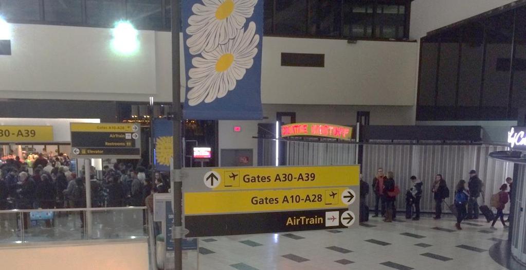
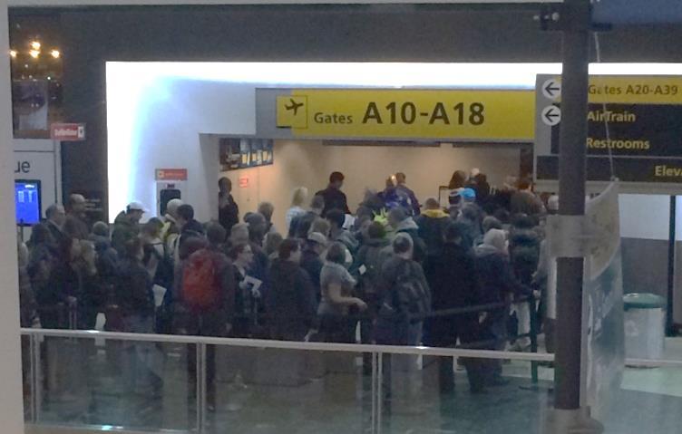
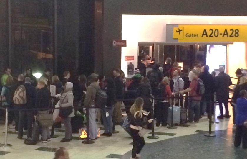
3 Daily Crowd Conditions


4 Planning Efforts Began In 2004 Yielded Redevelopment as the Best Option Restoration - $850 Million SGR Program for 30-Year Life Extension No Capacity Increase Limited Expansion Capability 6-Year Construction Duration Modernization - $2,064 Million SGR Program for 30-Year Life Extension Capacity Increase to the Limit of Existing Terminal Limited Expansion Capability 10-Year Construction Duration Redevelopment Option Redevelopment - $2,100 Million New 33 Gate Terminal Capacity Increase 1 st Phase of Long-Term Expansion Plan 4-Year Construction Duration Program Authorization - Redevelopment March 2016 for $2.3B Authorized Expenditures of $196.3M Modernization Options

5 Siting of the New Terminal A Terminal B Terminal C Terminal A

6 Terminal Location and Design $2.32 B Total Program Cost Approx 1M SF Terminal 2020 Partial Opening 2022 Full Opening 33 Gates 45 Gates 13.6 MAP Design Year

7 Program Includes Four Main Elements Airfield 140 Acres paving Demo existing buildings Design-Bid-Build Landside 8 new bridge structures At-grade roadway work Peripheral ditch work Design-Bid-Build Parking 3,000 spaces Toll plaza and revenue collection Design-Build Terminal 1M square foot terminal Frontage bridge Pedestrian bridge and ramp area Design-Build

8 Eight Construction Contract Packages

9 Overall Implementation Timeline
/Tail of Stand (TOS) Service Roads Maximize Staging Areas Inter-Terminal Bus")
10 Planning Criteria Design Day Flight Schedule (DDFS) Level of Service C During Peak Hour Operation 33 ADG III Aircraft Gates Dual Taxilanes Head of Stand (HOS)/Tail of Stand (TOS) Service Roads Maximize Staging Areas Inter-Terminal Bus Service

11 Planning Criteria Security Screening Process 2,350 Pax in Peak Hour (135 Pax/Lane/Hour) Queue Designed for Maximum 10 Minute Wait Flexible Infrastructure Screening Lanes to be Expandable TSA Support Space Unmanned Exit Vestibules

12 Planning Criteria Check-In Operations Curbside Positions 2.5 Minutes/Passenger Self Check-In Kiosks/No Bags 1.9 minutes/passenger Flexible Positions Check-In Islands Self Bag Tag/Drop Positions Airline-Specific Lounges Odd Size Bag Drops
 Airside Utilities and Paving (North) Bridges N61, N62 and N63 Demolition of Building 331 Terminal (Design/Build) RFIF RFQ - 4Q 2016 RFP - 1Q")
13 Current Status Projects In Construction Aviation Fueling System Modifications PSE&G 345 kv Switching Station Infrastructure Renewal Electrical Distribution Bridges N57, N58, N59 and Utilities Projects in Design Airside Utilities and Paving (South) Airside Utilities and Paving (North) Bridges N61, N62 and N63 Demolition of Building 331 Terminal (Design/Build) RFIF RFQ - 4Q 2016 RFP - 1Q 2017 Award - 1Q 2018 Construction

14 SITE PLAN Interior View at Check-In Lobby

15 SITE PLAN Interior View at Check-In Lobby Looking to Airside

16 SITE PLAN Interior View at Central Hall

17 SITE PLAN Interior View at East Pier Hammerhead

18 SITE PLAN Interior View at South Pier

19 SITE PLAN Interior View at Arrivals Hall

20 Exterior Landside View SITE PLAN

21 Exterior Landside View SITE PLAN
22 Aerial View of Site SITE PLAN
Adoption of the Rosslyn Sector Plan Site Plan Review Committee (SPRC) Meeting October 26, 2015
 Meeting October 26, 2015") Adoption of the Rosslyn Sector Plan Site Plan Review Committee (SPRC) Meeting October 26, 2015 Rosslyn Sector Plan Introduction Adopted by the County Board in July 2015 Reflects the new long range planning
Adoption of the Rosslyn Sector Plan Site Plan Review Committee (SPRC) Meeting October 26, 2015 Rosslyn Sector Plan Introduction Adopted by the County Board in July 2015 Reflects the new long range planning
Rosecrans/Marquardt Grade Separation Project. Community Open House Meeting
 Rosecrans/Marquardt Grade Separation Project Community Open House Meeting October 17, 2017 Rosecrans/Marquardt Presentation Agenda 1. Welcome Remarks & Introductions 2. Community Outreach 3. Project Goals
MARINA BAY. City of Richmond Officer Bradley A. Moody Memorial Underpass. April 14, 2010
 MARINA BAY NEIGHBORHOOD G O OO PRESENTATION S O City of Richmond Officer Bradley A. Moody Memorial Underpass April 14, 2010 TEAM INTRODUCTIONS Project Oversight and Approval City of Richmond Richmond Community
TIRZ 17/Redevelopment Authority Capital Improvements Plan Projects
 Gessner Widening: T-1701 What: Widen the road from a six-lane divided boulevard to an eight-lane divided boulevard street section, increase turn lanes, update traffic signal system, improve drainage by
Fall 2017 Construction Update
 Fall 2017 Construction Update Ward 4 Southeast Engineering Department Riverwalk Red Multi-Use Trail Bridge Rehabilitation The Riverwalk Red Multi Use Trail Bridge was awarded to Cramer and Associates,
Connecting Nine Buildings in Central Jakarta Together with the MRT. Mulyadi Janto, Director, PT Farpoint Prima
 Connecting Nine Buildings in Central Jakarta Together with the MRT Mulyadi Janto, Director, PT Farpoint Prima SEQUIS: INTER-SITE CONNECTIVITY 30/10/17 3.45pm 5.15 pm SEQUIS: INTER-SITE CONNECTIVITY 1.
Innovative Worldwide VE Case Studies & How Cultural Values Impact Creativity
 Innovative Worldwide VE Case Studies & How Cultural Values Impact Creativity August 30 - September 2, 2009 2009 AASHTO VE Conference San Diego, CA George Hunter, PE, PMP, CVS Value Management Strategies
Executive Summary. NY 7 / NY 2 Corridor
 Executive Summary NY 7 / NY 2 Corridor Transportation and Land Use Study December 2005 Prepared for: Town of Colonie Capital District Transportation Committee Prepared by: Introduction: Land use decisions
NOTICE AND OPPORTUNITY FOR PUBLIC COMMENT CYRIL E. KING (STT) AND HENRY E. ROHLEN (STX) AIRPORTS JANUARY 25, 2018
 AND HENRY E. ROHLEN (STX) AIRPORTS JANUARY 25, 2018") NOTICE AND OPPORTUNITY FOR PUBLIC COMMENT CYRIL E. KING (STT) AND HENRY E. ROHLEN (STX) AIRPORTS JANUARY 25, 2018 Overview The Virgin Islands Port Authority (Port Authority) intends to apply to the Federal
NOTICE AND OPPORTUNITY FOR PUBLIC COMMENT CYRIL E. KING (STT) AND HENRY E. ROHLEN (STX) AIRPORTS JANUARY 25, 2018 Overview The Virgin Islands Port Authority (Port Authority) intends to apply to the Federal
Dumbarton Rail Corridor. Project Scoping Meeting Nov 15, :15 PM City of Newark Nov 16, :15 PM City of Menlo Park
 Dumbarton Rail Corridor Project Scoping Meeting Nov 15, 2006 7:15 PM City of Newark Nov 16, 2006 7:15 PM City of Menlo Park 1 Presentation Overview I. Introduction History of the Project II. III. Purpose
East Corridor Final Environmental Impact Statement
 East Corridor Final Environmental Impact Statement Alternatives Considered Operating Plan The requirements for opening day operations versus year 2030 are based on ridership and operations. Opening day
Shelter and Evacuation Plan. 1.0 Purpose. Table of Contents. General Policies Revision # 0 Page # 1 of 25
 General Policies Revision # 0 Page # 1 of 25 1.0 Purpose The Kenton County Airport Board (KCAB) operates the Cincinnati/Northern Kentucky International Airport (CVG Airport) and sets policies, procedures,
Existing Conditions. Planning and Design Principles
 penn s south bank enn s South Bank is located south of the Schuylkill River at the intersection of 4th Street and. This acre former heavy industrial site offers the opportunity to accommodate a variety
FY 2005 TRANSPORTATION CAPITAL PROGRAM
 Camden County Civic Center Access Study, Pennsauken 03340 This project will address operational and access improvements on Routes 30, 73 and 90 related to the Crossroads redevelopment project around the
WELCOME TO OPEN HOUSE TWO November 28, 2018
 Langstaff Road Weston Road to Highway 7 Class Environmental Assessment Study WELCOME TO OPEN HOUSE TWO November 28, 2018 Please sign in and join our mailing list Study Overview York Region is conducting
Connected Airport INNOVATION TAKES FLIGHT. Taking the Intelligent Airport to New Heights
 Connected Airport INNOVATION TAKES FLIGHT Taking the Intelligent Airport to New Heights The sky s the limit. Propelling the connected airport into the future. HVAC Honeywell Enterprise Building Integrator
Connected Airport INNOVATION TAKES FLIGHT. Taking the Intelligent Airport to New Heights
 Connected Airport INNOVATION TAKES FLIGHT Taking the Intelligent Airport to New Heights The sky s the limit. Propelling the connected airport into the future. Forget Complicated. Think Integrated. Multiple
Mavis Road Class Environmental Assessment
 Mavis Road Class Environmental Assessment Public Information Centre #2 Wednesday November 9, 2016 6:00 to 8:00 p.m. Please sign in and complete a comment sheet Review the displays on your own or join in
5250 // PLAZA WELCOME TO CHARLOTTE S NEW WAY TO WORK, PLAY, + GATHER.
 5250 // PLAZA WELCOME TO CHARLOTTE S NEW WAY TO WORK, PLAY, + GATHER. MULTIMILLON DOLLAR RENOVATION UNDERWAY 5445 5435 5501 BUILD-TO-SUIT OPPORTUNITY 5301 5311 Minuet Ln 5500 5510 5601 5605 5550 5200 77
2017 Investment in Infrastructure Expo February 28, 2017 Jason Jonas, P.E. Public Works Director
 2017 Investment in Infrastructure Expo February 28, 2017 Jason Jonas, P.E. Public Works Director 1 Jefferson County, Missouri Road and Bridge Sales Tax: Jefferson County has a one-half cent sales tax that
Port of Seattle Street Vacations Summary April, 2016
 Port of Seattle Street Vacations Summary April, 2016 Since the question of street vacations provided to the Port was raised at the April 19 Sustainability and Transportation Committee, the Port is providing
McDonald s Restaurant - Purcellville Town of Purcellville Special Use Permit Statement of Justification July 24, 2014
 Introduction / Written Statement McDonald s Restaurant - Purcellville McDonald s Corporation is proposing to redevelop the existing McDonald s eating establishment with a drive-through located at 121 N
SHERIDAN PARKING STRUCTURE PUBLIC INFORMATION MEETING November 11, :00 pm - 8:00 pm
 SHERIDAN PARKING STRUCTURE PUBLIC INFORMATION MEETING November 11, 2010 6:00 pm - 8:00 pm 1 Project Area 2 Sheridan Parking Structure RTD Ownership 3 Project Elements Structure and amenities include: 1.
BATHURST QUAY NEIGHBOURHOOD PLAN IMPLEMENTATION. Streetscape & Public Realm Improvement Plan - Canada Malting Silo Site and Eireann Quay
 BATHURST QUAY NEIGHBOURHOOD PLAN IMPLEMENTATION Streetscape & Public Realm Improvement Plan - Canada Malting Silo Site and Eireann Quay Bryan Bowen, Waterfront Secretariat November 25, 2017 Presentation
ADDENDUM NO. 1 BID-CONTRACT DOCUMENTS FOR. RFP No Professional Design Services for CCC Le-Jao Student Resource Center
 ADDENDUM NO. 1 BID-CONTRACT DOCUMENTS FOR RFP No. 2030 Professional Design Services for CCC Le-Jao Student Resource Center COAST COMMUNITY COLLEGE DISTRICT COSTA MESA, CALIFORNIA COUNTY OF ORANGE COAST
FANSHAWE PARK ROAD/RICHMOND STREET INTERSECTION IMPROVEMENTS. PUBLIC INFORMATION CENTRE 2 June 16, 2016
 FANSHAWE PARK ROAD/RICHMOND STREET INTERSECTION IMPROVEMENTS Municipal Class Environmental Assessment PUBLIC INFORMATION CENTRE 2 June 16, 2016 ACCESSIBILITY Under the Accessibility Standards 2015 for
NorthPoint, Inc. Community-Based Development Concept
 NorthPoint, Inc. Community-Based Development Concept 6.0.01 EXECUTIVE SUMMARY The NorthPoint Community Board Development concept is a community development strategy. It leverages NorthPoint s mission,
Meeting Purpose: Date and Time: Location: Attendance: Handouts:
 Meeting Purpose: Date and Time: Location: Attendance: Handouts: PA Turnpike / I-95 Interchange Project Design Advisory Committee (DAC)/Public Officials Meeting #8 April 12, 2012 at 1:30 p.m. Project Office,
Planning and New Starts Development Committee. February 25, 2016
 Planning and New Starts Development Committee February 25, 2016 VB TRANSIT EXTENSION 2 Status of VBTES DEIS No Federal Environmental Decision Document Decision to build project with only State and City
Developer s Program. The Station at East 54
 Developer s Program The Station at East 54 Existing Conditions The Station at East 54 is proposed for a 1.12 acre site at the northeast corner of Hamilton Road and Prestwick Road, tucked between the East
Iowa 100 Extension Project Visualizations for Design and Public Involvement ASCE Transportation Conference November 6, 2013 Ames, Iowa
 Iowa 100 Extension Project Visualizations for Design and Public Involvement 2013 ASCE Transportation Conference November 6, 2013 Ames, Iowa Agenda Project Corridor Constraints Key Features Project History
St. Elizabeths East - 5 Year Anticipated Use Plan
 Agenda 1. Introductions 2. St Elizabeths East Overview 3. Stage One Infrastructure Improvements 1. Role of the D.C. Department of General Services and D.C. Department of Transportation 2. DC Water Tower
St. Clair Avenue West Area Transportation Master Plan
 1 (Between Keele Street and Old Weston Road) Public Information Centre 1 December 2, 2015 2 Welcome Welcome to the first Public Information Centre for the St. Clair Avenue West Area. The panels will present
North Commuter Parkway and Traffic Bridge Project Market Sounding
 North Commuter Parkway and Traffic Bridge Project Market Sounding Introduction KPMG LLP ( KPMG ) has been engaged by the City of Saskatoon ( the City ) to develop a P3 business case for the North Commuter
Request for Proposals
 Request for Proposals Charlestown Navy Yard Infrastructure Assessment Engineering Services The Boston Redevelopment Authority ( BRA )/Economic Development Industrial Corporation ( EDIC ) is issuing a Request
ALTERNATIVES. NCDOT made an early decision to first determine how to build the project (construction method) followed by what to build (alternatives).
 followed by what to build (alternatives).") III. ALTERNATIVES A. CONSTRUCTION METHOD ALTERNATIVES NCDOT made an early decision to first determine how to build the project (construction method) followed by what to build (alternatives). One of the
III. ALTERNATIVES A. CONSTRUCTION METHOD ALTERNATIVES NCDOT made an early decision to first determine how to build the project (construction method) followed by what to build (alternatives). One of the
The Ambassador Bridge/ Gateway Project
 The Ambassador Bridge/ Gateway Project Connecting Neighbors & Driving the Economy 2008 Ohio Conference on Freight Given by the Toledo Metropolitan Area Council of Governments, National Association of Regional
VICTORIA DOWNTOWN DEVELOPMENT PLANNING
 VICTORIA DOWNTOWN DEVELOPMENT PLANNING A Vision & Guide for the Future Downtown Victoria thrives as a center for the community, offering a great mix of entertainment, culture, business, and recreational
Ballston Station Multimodal Study. Stakeholder Meeting October 5, 2010
 Ballston Station Multimodal Study Stakeholder Meeting October 5, 2010 Agenda Welcome and Introductions Update on Short Term Improvements Update on the Multimodal Study Recap of Goals and Key Issues Working
Tysons Circulator Study: Process and Preliminary Results Summary. March 2012
 Tysons Circulator Study: Process and Preliminary Results Summary March 2012 Background: 1. The Comprehensive Plan for the Tysons Corner Urban Center calls for a System of Circulators in Tysons Corner to:
ATSP3. Advanced Technology Support Program III. Comprehensive Solutions for Obsolescence and Performance Issues:
 Advanced Technology Support Program III ATSP3 Comprehensive Solutions for Obsolescence and Performance Issues: Electronic Hardware Software Design Integrated System and Sub-Systems Honeywell Aerospace
GREENVILLE-SPARTANBURG AIRPORT DISTRICT REQUEST FOR PROPOSALS FOR DEVELOPMENT SERVICES FOR GSP AIR CARGO FACILITY PHASE 1
 GREENVILLE-SPARTANBURG AIRPORT DISTRICT REQUEST FOR PROPOSALS FOR DEVELOPMENT SERVICES FOR GSP AIR CARGO FACILITY PHASE 1 Addendum No. 1 February 6, 2018 The respondent shall acknowledge all issued addenda
Route 110 Alternatives Analysis
 Route 110 Alternatives Analysis Public Meeting #1 December 15, 2014 Source: Town of Babylon Agenda Welcome/Introduction Hon. Antonio A. Martinez Deputy Supervisor, Town of Babylon Update on East Farmingdale
A. INTRODUCTION B. NO ACTION ALTERNATIVE
 Chapter 19: Alternatives A. INTRODUCTION Over the years a variety of potential developments for the East River waterfront in Lower Manhattan have been considered. Some of these plans were very ambitious
Staff Report. Re: National Park Service Ferry Landing Facilities at Piers 31, 31½ and 33 Joint Meeting with BCDC Design Review Board
 Port of San Francisco Waterfront Design Advisory Committee Agenda Item No. 2 Meeting Date: January 22, 2018 Staff Report To: From: Waterfront Design Advisory Committee: Laura Crescimano Jeff Joslin Marsha
An Urban Transportation Perspective of Mumbai, The Maximum City
 4 February 2015 An Urban Transportation Perspective of Mumbai, The Maximum City Prof. K V Krishna Rao Civil Engineering Department Indian Institute of Technology Bombay India No. of Cities with population
DOWNTOWN JACKSONVILLE MASTER PLAN S T R E E T H I E R A R C H Y
 DOWNTOWN JACKSONVILLE MASTER PLAN S T R E E T H I E R A R C H Y Gateway Intra-District Business Inter-District 44 CELEBRATING THE RIVER: A PLAN FOR DOWNTOWN JACKSONVILLE The Transportation Network This
POTOMAC YARD METRORAIL STATION
 POTOMAC YARD METRORAIL STATION DRAFT ENVIRONMENTAL IMPACT STATEMENT EXECUTIVE SUMMARY R Introduction Environmental Impact Statement for a New Metrorail Station at Potomac Yard The Federal Transit Administration
ROAD CONSTRUCTION. 36 June 2014 ROADS&BRIDGES
 ROAD CONSTRUCTION 36 June 2014 ROADS&BRIDGES Young is full of life Recent expansion completes continuous, multilane arterial By Donald Hammack, P.E. Contributing Author The Florida Department of Transportation
Mill Woods Town Centre Proposed Rezoning LDA
 Mill Woods Town Centre Proposed Rezoning LDA15 0649 The City of Edmonton has received an application for rezoning and an amendment to the Mill Woods Station Area Redevelopment Plan (ARP) for the Mill Woods
Downtown Elkton Station Area Plan, Elkton, MD. Difficult enough to get support for new starts challenge to fund Houston transit
 Difficult enough to get support for new starts challenge to fund Houston transit More difficult to build Community Support for dense development at station areas Major Concerns: Traffic, Property values,
I-90 ALLSTON INTERCHANGE A MULTIMODAL TRANSPORTATION PROJECT PUBLIC INFORMATION MEETING SEPTEMBER 18, 2014 JACKSON MANN COMMUNITY CENTER
 I-90 ALLSTON INTERCHANGE A MULTIMODAL TRANSPORTATION PROJECT PUBLIC INFORMATION MEETING SEPTEMBER 18, 2014 JACKSON MANN COMMUNITY CENTER 1 Project Need Deteriorating viaduct requiring replacement All Electronic
AASHTO SUBCOMMITTEE ON DESIGN. June 15, 2006 MARK ROBINSON, P.E. DISTRICT 5 INTERSTATE PROGRAM MANAGER FLORIDA DEPARTMENT OF TRANSPORTATION
 AASHTO SUBCOMMITTEE ON DESIGN June 15, 2006 MARK ROBINSON, P.E. DISTRICT 5 INTERSTATE PROGRAM MANAGER FLORIDA DEPARTMENT OF TRANSPORTATION CENTRAL FLORIDA INTERSTATE 4 FACTS Trucks and Others 12% Tourist
The purpose of tonight s PIC is to:
 The purpose of tonight s PIC is to: Provide an overview of the work completed to date and a summary of the Class EA process being followed; Provide a summary of public input received so far, including
TRANSPORTATION COMMITTEE
 TRANSPORTATION COMMITTEE CITY OF OTTAWA Ministry of Transportation Detailed Design Assignment G.W.P.# 4058-01-00 Highway 417 (Ottawa Queensway) Widening & Rehabilitation from Maitland Avenue to Island
Taming the Bus: Strategies for Urbanizing Suburban Transit. Seth Riseman, Utile, Inc. Architecture + Planning
 Taming the Bus: Strategies for Urbanizing Suburban Transit Seth Riseman, Utile, Inc. Architecture + Planning Taming the Bus Strategies for Urbanizing Suburban Transit Stations Seth Riseman http://utile.posterous.com
FDOT/FTBA Construction Conference Work Plan
 FDOT/FTBA Construction Conference 19 2019 2023 Work Plan Ben Dreiling, P.E., Director of Construction Central Florida Expressway Authority January 18, 2019 Major Projects Map FY 2019-2023 Work Plan 2 FY
March 13, Government Center Station. Project Briefing
 March 13, 2013 Government Center Station Green Reconstruction Line / Blue Project Line Option for Green Construction Line / Blue Staging Line Project Briefing February 12, 2010 Project Purpose Accessibility
Jim Harkins DUNDEE WATER FRONT CIRCULATOR DUNDEE WATER FRONT CIRCULATOR. Specialists in Affordable & Sustainable Tramways. A short presentation by
 DUNDEE WATER FRONT CIRCULATOR DUNDEE WATER FRONT CIRCULATOR A short presentation by Jim Harkins Light Rail (UK) Specialists in Affordable & Sustainable Tramways www.lightrailuk.com E-mail Lightrailuk@aol.com
I-95 Interchange & Ellis Road PD&E Study
 I-95 Interchange & Ellis Road PD&E Study Brevard County, Florida Presentation to the Space Coast TPO October 14, 2010 The Project Provide a New Interchange with I-95 Using the Ellis Road Corridor, Extend
REQUIRED CHECKLIST FOR Better Streets Plan Section 138.1(c)(2)
(2)") REQUIRED CHECKLIST FOR Better Streets Plan Section 138.1(c)(2) Planning Department 1650 Mission Street Suite 400 San Francisco, CA 94103-9425 Pursuant to Planning Code Section 138.1 and Administrative
REQUIRED CHECKLIST FOR Better Streets Plan Section 138.1(c)(2) Planning Department 1650 Mission Street Suite 400 San Francisco, CA 94103-9425 Pursuant to Planning Code Section 138.1 and Administrative
The Project. In 2013, construction was completed between 100 Street and 102 Street.
 The Project Jasper Avenue New Vision (JANV) is a major catalyst project identified in the Capital City Downtown Plan (2010) between 92 Street and 109 Street, including the streets half a block north and
I-84 Hartford Project Open Planning Studio #12. April 25, 2017
 I-84 Hartford Project Open Planning Studio #12 April 25, 2017 Meeting Agenda 1. I-84 Hartford Project alternatives update 2. Multimodal station area planning 3. I-84 / I-91 Interchange Study coordination
RESOLUTION NO. WHEREAS, the City of San José (City ) owns and operates the Norman Y. Mineta San José International Airport ( Airport ); and
 owns and operates the Norman Y. Mineta San José International Airport ( Airport ); and") RESOLUTION NO. A RESOLUTION OF THE COUNCIL OF THE CITY OF SAN JOSE AUTHORIZING THE NORMAN Y. MINETA SAN JOSE AIRPORT TO SOLE-SOURCE CERTAIN PRODUCTS AND/OR SERVICES AS PART OF ANY FUTURE CAPITAL IMPROVEMENT
RESOLUTION NO. A RESOLUTION OF THE COUNCIL OF THE CITY OF SAN JOSE AUTHORIZING THE NORMAN Y. MINETA SAN JOSE AIRPORT TO SOLE-SOURCE CERTAIN PRODUCTS AND/OR SERVICES AS PART OF ANY FUTURE CAPITAL IMPROVEMENT
5.2 LAND USE AND ZONING
 5.2 LAND USE AND ZONING This section describes the land use and zoning of the project site and surrounding area, followed by an analysis of the potential for incompatibility or adverse impact on prevailing
Ohlone College Measure G Project Scope Revisions
 Scope Revisions Current Title Revised Title Current Scope Revised Scope 6101 Relocated Baseball Field Athletic Fields Create new sustainable baseball field with synthetic turf, bleacher seating and batting
Grand Rail Commercial Development Site Plan Application
 Grand Rail Commercial Development Site Plan Application April 27, 2012 Memo To: North Liberty Planning Commission From: Dean Wheatley, Planning Director Subject: Site Plan Approval Request for 725 Pacha
Taming Tysons Corner Transforming the Quintessential Edge City
 Taming Tysons Corner Transforming the Quintessential Edge City Transit is the greatest catalyst for change at Tysons, but how do we take advantage of this billion-dollar investment? If transit is built
Public Works Project Delivery Report
 Public Works Project Delivery Report May 2017 San Gabriel Public Works delivers reliable infrastructure & welcoming public spaces by designing, constructing, operating & maintaining the City s streets,
West Gate Tunnel panel hearing
 Source: Western Distributor Authority Alison Whitten Master in Urban Planning Bachelor of Science in Systems Engineering James Whitten Master of Architecture in Urban Design Bachelor of Architecture Bachelor
Principal development issues
 Principal development issues The transformation of the Bonaventure Expressway from Saint- Jacques to Brennan Streets will create a major urban boulevard with lanes located on either side of a string of
The Lincoln Neighborhood Corridor Plan. The LiNC
 October 1, 2014 Planning Commission Study Session The Lincoln Neighborhood Corridor Plan The LiNC Purpose of Tonight s Meeting Introduction to The LiNC Review of Existing Conditions and Community Identified
6:00 8:00 PM I-95 FROM EXIT 57 TO EXIT 60 PROJECT
 PUBLIC INFORMATIONAL MEETING TUESDAY, APRIL 27, 2010 AT NEWBURYPORT CITY HALL, AUDITORIUM 60 PLEASANT STREET NEWBURYPORT, MASSACHUSETTS 6:00 8:00 PM FOR THE PROPOSED WHITTIER BRIDGE / I-95 IMPROVEMENTS
How it may affect the future of your school. Michael France Director, Regulatory Affairs National Air Transportation Association
 How it may affect the future of your school Michael France Director, Regulatory Affairs National Air Transportation Association NATA Activities NFPA 409 Overview History of NATA s involvement with NFPA
The Phibbs Bus Exchange Redesign: From Concrete and Asphalt to Raingardens and Bridges!
 The Phibbs Bus Exchange Redesign: From Concrete and Asphalt to Raingardens and Bridges! Michelle Babiuk, Project Manager, Infrastructure and Network Management, TransLink Bernard Abelson, Transportation
District Facilities Master Plan
 W o r k s h o p B o a r d District Facilities Master Plan February 29, 2012 BACKGROUND + CONTEXT ANALYSIS OPTIONS RECOMMENDATIONS NEXT STEPS DFMP AGENDA BACKGROUND + CONTEXT ANALYSIS OPTIONS RECOMMENDATIONS
Welcome to the. Open House
 Welcome to the 5th Street to Kinsman Road Open House November 14 5:30 7:00 p.m. Please sign in Project Overview In December 2016, City Council adopted SW 5th Street as the preferred alignment to connect
2.0 PURPOSE AND NEED. 2.1 Purpose. 2.2 Need Traffic Congestion in and around Downtown Derry
 2.0 PURPOSE AND NEED Taking into consideration agency and public input, the purpose and need for the Project was identified early in Project planning. As noted in Appendix A, for purposes of meeting the
Cold Lake Marina Master Plan
 Cold Lake Marina Master Plan Intro to Team Moffatt & Nichol is recognized throughout the world for our role in the revitalization and redevelopment of urban waterfronts, including the evolution of modern
UAA School of Engineering Parking Garage Master Plan Amendment. 1. Purpose
 UAA School of Engineering Parking Garage Master Plan Amendment 1. Purpose Since the UAA campus master plan was drafted in 2003, adopted in 2004, and amended in 2009 a number of significant changes regarding
112th Avenue Light Rail Options Concept Design Report JUNE 2010 PREPARED FOR PREPARED BY TBG PGH
 112th Avenue Light Rail Options Concept Design Report JUNE 2010 PREPARED FOR PREPARED BY TBG060310124909PGH C ontents Introduction 1 Project Overview 1 Public Involvement and Technical Coordination 4 Description
DENVER INTERNATIONAL AIRPORT. Photo provided courtesy of Denver International Airport
 DENVER INTERNATIONAL AIRPORT Photo provided courtesy of Denver International Airport VIEW OF EXISTING JEPPESEN TERMINAL, LOOKING SOUTH Photo provided courtesy of Denver International Airport South Terminal
Johnson Street Bridge Public Realm Update
 Johnson Street Bridge Public Realm Update August 20, 2015 Background Johnson Street Bridge Replacement Project impacts a diverse range of stakeholders In addition to a new bridge, the project also includes
ASPEN HILL Minor Master Plan Amendment
 ASPEN HILL Minor Master Plan Amendment Project Briefing Planning Board Agenda Item #7 Andrea Gilles, Area 2 June 5, 2014 Briefing Purpose 1. Follow-up evaluation on Mixed-Use land use in the Minor Amendment
THE COUTURE AT A GLANCE $122 MILLION TOTAL PROJECT COST 44 STORIES / 700,000 SQUARE FEET PUBLIC PLAZAS, PARK & PEDESTRIAN BRIDGES 302 MARKET RATE
 MILWAUKEE THE COUTURE AT A GLANCE $122 MILLION TOTAL PROJECT COST 44 STORIES / 700,000 SQUARE FEET PUBLIC PLAZAS, PARK & PEDESTRIAN BRIDGES 302 MARKET RATE APARTMENTS 54,893 SQUARE FEET OF DESTINATION
Commercial Node Plan Devine Street/Jackson Blvd. COLUMBIA, SC
 Commercial Node Plan Devine Street/Jackson Blvd. COLUMBIA, SC 9.17.13 AGENDA 1 Introductions 2 Project Update 3 Concepts 4 Recommendations 5 Next Steps Introductions Project Update Process 5-Phase Process
Midtown Corridor Alternatives Analysis. Appendix A - Initially Considered Alternatives Screening
 Midtown Corridor Alternatives Analysis Appendix A - Initially Considered Alternatives Screening Arterial BRT on Lake Street - Overall Rating: RATING Metropolitan Council recommendations stated in the Transportation
HARBOR BRIDGE. Randall C. Grones, PE - SPD. US 181 Harbor Bridge October
 HARBOR BRIDGE Randall C. Grones, PE - SPD US 181 Harbor Bridge October October 13, 13, 2015 2015 Project Scope Develop, design, construct and maintain a total project length of 6.44 miles. Base scope New
WASHINGTON DC METROPOLITAN AREA QUALIFICATIONS
 WASHINGTON DC METROPOLITAN AREA QUALIFICATIONS CONTACT Arlington Virginia 1300 Wilson Boulevard Suite 450 Arlington VA 22209-2323 571.366.6800 571.366.6801 JOHN F. KENNEDY CENTER FOR THE PERFORMING ARTS
THE GARDEN CITY PLAN. City of St. Catharines Official Plan. City of St. Catharines
 THE GARDEN CITY PLAN City of St. Catharines Official Plan City of St. Catharines August 2010 APPROVAL INFORMATION This Official Plan of the City of St. Catharines Planning Area, known as the Garden City
Welcome. to the 95th Street Terminal Improvement Project Public Hearing
 Welcome to the 95th Street Terminal Improvement Project Public Hearing The purpose of this Public Hearing is to solicit comments from the community about the Environmental Assessment prepared for the 95th
Project Overview. Fairfax County Parkway Widening Fairfax County. Get Involved. Public Information Meeting. Contact Information
 Get Involved VDOT representatives will review and evaluate information received as a result of this meeting. Please fill out the comment sheet provided in this brochure if you have any comments or questions.
Public Open House. Overview of the Downtown Plan Official Plan Amendment April 23, 2018
 Public Open House Overview of the Downtown Plan Official Plan Amendment April 23, 2018 1 A 25-Year Plan for Downtown To ensure growth contributes positively to Toronto s Downtown as a great place to live,
Silver Line CPAM UPDATE. Transportation and Land Use Committee October 14, 2016
 Silver Line CPAM UPDATE Transportation and Land Use Committee October 14, 2016 Purpose Recap Project History and Map Changes Provide Overview of CPAM Components Discuss Transportation Impacts Discuss Fiscal
Appendix G Response to Comments
 Appendix G Response to Comments This appendix contains the comments received during the public circulation and comment period (May 27, 2008 to July 11, 2008). The comments have been numbered (Comment Set
Courtice Main Street Study Community Vision Workshop PLANNING SERVICES DEPARTMENT
 Courtice Main Street Study Community Vision Workshop PLANNING SERVICES DEPARTMENT July 22, 2009 Tonight s Meeting 7:00 pm Introduction David Crome, Director of Planning 7:05 Presentation Stasia Bogdan,
The Residences at Alewife Station
 The Residences at Alewife Station 195 & 211 Concord Turnpike Community Meeting Peabody School November 10, 2016 Site Context Special District 4 Special District 4 Restored Planned Development Special District
POLICY AMENDMENT AND LAND USE AMENDMENT KILLARNEY/GLENGARRY (WARD 8) NW CORNER OF RICHMOND ROAD AND 33 STREET SW BYLAWS 1P2015 AND 7D2015
 NW CORNER OF RICHMOND ROAD AND 33 STREET SW BYLAWS 1P2015 AND 7D2015") Page 1 of 13 EXECUTIVE SUMMARY This application seeks to redesignate an RC-2 (Residential Contextual One/Two Dwelling) parcel to MC-Gd72 (Multi-Residential Contextual Grade-Oriented) to allow for multi-residential
Page 1 of 13 EXECUTIVE SUMMARY This application seeks to redesignate an RC-2 (Residential Contextual One/Two Dwelling) parcel to MC-Gd72 (Multi-Residential Contextual Grade-Oriented) to allow for multi-residential
Aviation Solutions. Why Tyco for airports? Our systems help protect over 110 airports. Secures over 80% of UK Airports and more than 60 US Airports
 Aviation Solutions Why Tyco for airports? Our systems help protect over 110 airports Secures over 80% of UK Airports and more than 60 US Airports Tyco has the only dedicated airport specific access control
2 Project Description
 Project Description 2 Project Description The proposed project would involve the demolition of the existing church and the construction of 40 twostory single family residences. The residential lots would