Partial Local Plan Review of the South Malta Local Plan (2006) as amended. Area at Hal-Mula, Zebbug
|
|
|
- Hope Garrison
- 5 years ago
- Views:
Transcription
1 Partial Local Plan Review of the South Malta Local Plan (2006) as amended Area at Hal-Mula, Zebbug Planning Authority February 2017
2 Table of Contents 1.0 Scope and Objectives Strategic and Local Planning Guidance Amended Policy Guidance for Hal-Mula Area, Zebbug Public Consultation 12 Appendix 1: Public Consultation Submissions Report Objectives Phase 1 13
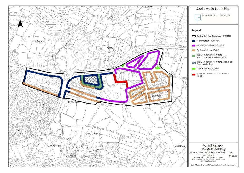
3 1.0 Scope and Objectives 1.1. Following the request from Government to the Planning Authority, the Planning Directorate initiated a Partial Local Plan Review of the South Malta Local Plan (2006) for the Area at Hal-Mula in Zebbug (as shown in Map 1 below). The purpose of this review is to set the planning parameters (land use zoning, building heights and road alignments) for the development of the area. The Government Objectives listed below aim to address the conflicting development patterns and mix of land uses that currently exist leading to the deterioration of the quality of life of residents living within the area: To establish the relevant planning parameters for the area shown on the attached map; and To seek to reduce deleterious impacts on predominantly residential areas from other incompatible land uses In the Phase 1 Public Consultation on the Government Objectives, held between 16th August, 2016 and 19th September, 2016, 19 submissions were received from stakeholders in the area. These submissions included: 10 submissions from residents objecting to the impact of industrial activity and also requests to increase the residential zoning (Areas indicated as Area A in the partial local plan review of 2007 (PC 62/07)); 5 submissions that relate to retaining the area for industrial SME garages as originally zoned (Areas indicated as Area B in the partial local plan review of 2007 (PC 62/07)); 3 submissions that relate to as yet undeveloped large sites, indicating an interest in the future planning of this area; and 1 submission to increase the building height along Triq L-Imdina. The submissions and PA responses are included in Appendix 1 Public Submissions Phase 1 Objectives The Hal-Mula Area at Zebbug is located just south of Triq L-Imdina, a busy and major road network route, north of Triq Dun Luret Callus and Triq Luret Cutajar, east of Triq Ganni Bonnici and west of the Strategic Open Gap between Zebbug and Qormi, and has a total area of around 0.18km² The Hal-Mula area is mostly developed, consisting of industrial/warehousing/storage related buildings, commercial buildings mainly facing the main access roads including Triq l-imdina and various residential land uses mostly located on the upper floors overlying other ground floor uses including both SMEs and private car garages. The road network in the area is also already in place. A limited number of sites are still vacant providing potential for further development. The area is characterised by a long history of mixed developments resulting in an interlocking of varying conflicting land uses. The nature of the area has changed substantially from the original Temporary
4 Provision Schemes, 1988 industrial land use zoning with a resultant growth in residential and commercial land uses in a number of streets. This originated mostly from the previous casa bottega type of developments but increased over time with the development of upper floors as additional residential units and premises fronting the main road as commercial units The area in question currently has a poor quality environment with a dense mixed use, high activity urban area of incompatible land uses that needs to be addressed. The partial review attempts to improve the quality of this area by rezoning into more specific character areas aimed to reduce the mix of use in the longer term. In this respect, the previous mixed use zoning is not being recommended further as this is less likely to reduce deleterious activity from past experiences than the following of a separate zoning strategy based on clustered predominant land uses It is highlighted that although the planning tool of separate zoning can be utilised to create more distinct clusters of uses, operating entities with older permits cannot legally be guided to cease operations or be relocated. These will therefore continue to operate as per permit conditions unless redeveloped in future where the latest approved zoning would legally be applicable. It is emphasised that the possession and existence of an approved permit does not imply that operational transgressions are acceptable and such land uses are required to operate sustainably in the interest of an improved street environment New public demands for a further review are once again requesting a departure from the present mixed use situation that has led to an increased complexity in the land use of the area and also the need to take into account the extent of increased residential development in certain parts of the area. This partial review acknowledges a number of predominantly dwelling areas as residential areas. Furthermore, the potential of zones facing the arterial road, Triq L-Imdina, for commercial development with retail and showroom land uses along the main road frontages is also being acknowledged in the rezoning exercise. A number of other areas are also being retained specifically as industrial areas as per original TPS 1988 zoning, rather than mixed use. This is to ensure the continuity of the industrial function in the area with the incentive to redevelop also as commercial, from industrial.

5 Map 1: Hal-Mula Area, Zebbug
6 2.0 Strategic and Local Planning Guidance 2.1. The Strategic Plan for the Environment and Development (SPED, 2015) considers and guides developments within the Urban Area in line with the Vision in Section 1.27 as follows: The Urban Area shall become an attractive place for people to live, work, play and interact. It shall be a clean, pollution free, safe The SPED 2015 strategic guidance is to improve upon areas with existing deleterious impacts and attempts to ameliorate on their current situation by reducing conflict and incompatibility between existing land uses. This is a complex goal. However, through this partial review exercise, existing industrial operations with permit will continue to be supported in view of their economic importance, still, the need to protect amenity of adjacent uses and surrounding areas and improve upon the street environment of the area is also being prioritised by this re-planning exercise SPED Policy TO 6.1 in effect is applicable as it requires the safeguarding of environmental health from deleterious impacts as follows: Controlling the location, design and operation of development Furthermore under SPED Urban Objective 3, SPED Policy UO 3.4 and 3.5 call for the following, respectively: Identifying sites which are derelict, in a state of abandonment, of poor quality or include incompatible uses and seek their upgrading through high quality development. Controlling the proximity of non-residential uses in urban areas This area was originally zoned in the Temporary Provision Schemes (TPS, 1988) as an industrial area. It was rezoned within the SMLP (2006) as a Mixed Use Area subdivided into two main zoning types Area A and Area B zoning through Area Policy SMZG01 and Map ZG2 Zebbug East. The Mixed Use Area zoning was introduced in view of a mix of industrial, commercial and residential land uses most of which are incompatible and with conflicting land uses and arising at different levels including also incompatible ground and upper floors, apart from adjacent properties.
7 2.6. Following the Local Plan rezoning of the area in 2006, the issues arising from differences in zoning led to an increase in public demands for a further review. This review was followed through a partial local plan review carried out in 2007 which rezoned the area once again, amending the coverage of the Areas A and B zoning to try to address the situation. The areas that were zoned as Area B which prohibited the intensification of residential land use were increased in this planning exercise. This led to public complaints from residents in the area, who demanded further change leading to the request of this latest planning review The Partial Review attempts to improve the quality of these areas by rezoning into more specific character areas, thereby reducing mixed use. In this respect, the previous mixed use zoning category is not being recommended to be sustained further as this is more likely to increase deleterious impacts.
8 3.0 Amended Policy Guidance for Hal-Mula Area, Zebbug 3.1. The following Policy SMZG01 is to replace the previous approved policy for the Hal- Mula Area, Zebbug and its associated policy map. Development within this area is to conform to the following parameters: SMZG01 Hal-Mula Area, Zebbug Within the Hal-Mula Area, Zebbug as indicated on the Map SMHM 1 the Planning Authority will consider development applications subject to the following parameters: Land Use Framework 1. Within the areas designated as Industrial (Small and Medium Enterprise) Areas, only the following land uses are permitted: (i) All Classes in Category D Commercial Uses - Development Planning (Use Classes) Order, 2014; (ii) Class 5A Light Industry and 5B General Industry - Development Planning (Use Classes) Order, 2014; (iii) Class 6A, Storage and Distribution - Development Planning (Use Classes) Order, 2014; (iv) Taxi Business, hire of motor vehicles or public service garage. 2. Within the areas designated as Commercial Areas, all Classes in Category D Commercial Uses - Development Planning (Use Classes) Order, Within the areas designated as Residential Areas, the land uses listed under the General Policy SMHO02 are acceptable with the exception of supermarkets and business and light industry. Development Parameters Within all designated areas: In the case of existing permitted developments that are not in line with the assigned land use for the area these will continue to operate as per existing permit conditions. When a development planning application which involves a redevelopment/intensification/change of use is submitted, the new land use parameters above will become applicable.
9 The building heights of this area, as indicated in Map SMHM 1, shall not exceed the maximum allowable height of 17.5 m as per Development Control Design Policy, Guidance and Standards 2015 (DC15). New and/or redevelopment proposals shall lead to a general improvement in the appearance of the area, with form and treatment of the elevations that enhance through improved design the streetscape and the surrounding environment. Triq Dun Bartilmew Attard Environmental Improvements In cases of new development or redevelopment of plots with a frontage onto Triq Dun Bartilmew Attard as shown on Map SMHM 1, environmental improvement measures will be encouraged by the Planning Authority that include: 1. The the exclusion of Classes 4C and 4D - Development Planning (Use Classes) Order, 2014, within the Commercial Area; 2. A minimum 6.5 m setback at street level from the existing building alignment for properties with a frontage within the block as identified on Map SMHM 1, for the provision of additional on-street parking or soft landscaped areas. The loss of gross developable floorspace (GDF) through this provision may be considered over and above the stipulated height limitation. Consideration of the Elimination of Schemed Road The schemed road connecting Triq il-kataniz to Triq L-Imdina as shown on Map SMHM 1 is to be considered for deletion provided that all the properties having frontage on the schemed road are under single ownership.
10 3.2. Hal-Mula was designated as a mixed use area in the South Malta Local Plan in 2006, and reviewed in 2007, in view of the mix of land uses that include industrial, commercial and residential land uses, the latter overlying industrial or commercial concerns. The area was originally zoned as an industrial area in the Temporary Provision Schemes of However over time the number of permitted residential and commercial land uses increased, to the extent that the urban character and use-mix of the area has changed substantially from the previous zoning in a number of areas. This has led to the need to address the current situation. Much present activity is incompatible and conflicting, leading to a situation of increased public complaints ensuing from an urban environment declining in quality Despite the previous amendments the predominant operational issues have remained. The current mixed use area zoning has not been successful in addressing the incompatibility of uses faced in the area. The reviewed policy framework is therefore intended to ameliorate on the current situation by departing from the mixed use planning concept and controlling deleterious activity. This should lead to an improved quality of life and increased compatibility between the different land uses in the area, especially in the longer term. A poor quality urban environment is detrimental and unacceptable, regardless of whether the land use activity includes industrial, commercial or residential uses. In this respect, a separate zoning strategy is being followed that clearly defines the allowable land uses in the area subject to a continuation of present use for existing land uses with permit until redevelopment is proposed. 3.4 During the initial public consultation submissions related to issues within Triq Dun Bartilmew Attard were raised. This street is being specifically addressed in view of its particular narrow configuration coupled with the mix of land use activity in this area and the concentration of residential uses within a specific stretch of this road. The policy seeks to achieve environmental improvement by requiring a setback of 6.5m from current alignment to facilitate provision of additional space for public parking and soft landscaping subject to a consideration of retention of overall allowable Gross developable Floorspace (GDF). The additional space above height limitation will need to be assessed in terms of its visual impact on the surroundings. 3.5 The study area includes a schemed road which has been planned since 1985 but never implemented. This review has assessed the need for this road and when considering its irregular alignment, restricted width and permitted development which encroach on its alignment there is adequate justification for its elimination. However it needs to be ascertained that the elimination of this road does not affect third party development potential.
11
12 4.0 Public Consultation 4.1 The Planning Authority invites individuals and organizations to send their representations pertaining to the Partial Local Plan Review of the South Malta Local Plan (2006), as amended, for Hal-Mula, Zebbug. Representations are to be made in writing to the: The Director of Planning, Planning Authority, Partial Local Plan Review of the South Malta Local Plan (2006) Hal-Mula, Zebbug P.O. Box 200, Marsa GPO 01 or on the address: Submissions are to be sent to the Authority by Monday 03rd April 2017.
Figure 1- Site Plan Concept
 Figure 1- Site Plan Concept Parking will be provided underground on three levels at rate of 1.0 space/ unit; this rate includes all visitors parking. MMM Group has prepared a parking assessment (April,
and services The protection and conservation of environmentally significant and sensitive natural heritage features and functions.
 6. Land Use 6.0 Preamble A healthy and livable city is one in which people can enjoy a vibrant economy and a sustainable healthy environment in safe, caring and diverse neighbourhoods. In order to ensure
Derry City and Strabane District Council Planning Committee Report
 Derry City and Strabane District Council Planning Committee Report COMMITTEE DATE: 23 rd March 2016 APPLICATION No: APPLICATION TYPE: PROPOSAL: LOCATION: APPLICANT: LA11/2015/0395/F Residential Development
Suffolk Coastal Local Plan Review Issues and Options, August 2017, Public Consultation
 Suffolk Coastal Local Plan Review Issues and Options, August 2017, Public Consultation Having reviewed the issues and options documents, the Society has made the following response: Part 1 - Strategic
Description Details submitted pursuant to discharge of condition 5 (Design Code) attached to planning permission 13/01729/OUT.
 attached to planning permission 13/01729/OUT.") ITEM 9 Application Number: 18/00266/DISCON Description Details submitted pursuant to discharge of condition 5 (Design Code) attached to planning permission 13/01729/OUT. AT The Point, 602 Midsummer Boulevard,
ITEM 9 Application Number: 18/00266/DISCON Description Details submitted pursuant to discharge of condition 5 (Design Code) attached to planning permission 13/01729/OUT. AT The Point, 602 Midsummer Boulevard,
SECTION E. Realizing the Plan
 SECTION E Realizing the Plan 60 DESIGN REGINA - OFFICIAL COMMUNITY PLAN SECTION E Realizing the Plan Design Regina has been an ambitious plan-making exercise, with a high level of community, stakeholder,
South Worcestershire Development Plan. South Worcestershire Design Guide Supplementary Planning Document
 South Worcestershire Development Plan South Worcestershire Design Guide Supplementary Planning Document Statement of Consultation: Early Engagement Scoping Paper February 2017 1. Introduction 1.1 This
2.0 Strategic Context 4
 2.0 Strategic Context 4 2.1 The Area Action Plan is a non-statutory plan, which forms a corporate policy document, expressing particular issues and areas of concern while also providing a vision for the
4 RESIDENTIAL ZONE. 4.1 Background
 4 RESIDENTIAL ZONE 4.1 Background The residential areas within the City are characterised by mainly lowrise dwellings sited on individual allotments. Past architectural styles, settlement patterns and
4155 Yonge Street Official Plan Amendment and Rezoning Application Preliminary Report
 STAFF REPORT ACTION REQUIRED 4155 Yonge Street Official Plan Amendment and Rezoning Application Preliminary Report Date: May 5, 2011 To: From: Wards: Reference Number: North York Community Council Director,
Planning and Regulatory Committee 20 May Applicant Local Councillor Purpose of Report
 Planning and Regulatory Committee 20 May 2014 7. APPLICATION FOR PLANNING PERMISSION FOR THE CARRYING-OUT OF DEVELOPMENT PURSUANT TO PLANNING PERMISSION REFERENCE NUMBER 603451 DATED 28 FEBRUARY 2007 WITHOUT
I615. Westgate Precinct
 I615. Westgate Precinct I615.1. Precinct Description The Westgate Precinct is located approximately 18km west of the Auckland city centre. There are seven Sub-precincts in the Westgate Precinct: Sub-precinct
Parish of Repton NEIGHBOURHOOD DEVELOPMENT PLAN
 Parish of Repton NEIGHBOURHOOD DEVELOPMENT PLAN BASIC CONDITIONS STATEMENT December 2018 CEF 4 Legal Requirements This statement has been produced by the NDP Working Group on behalf of Repton Parish Council
Urban Design Expert Evidence Leanne Hodyl
 Fishermans Bend GC81 Panel Hearing Urban Design Expert Evidence Leanne Hodyl 14 March 2018 1 Fishermans Bend GC81 Panel Hearing - Urban Design Expert Evidence Leanne Hodyl Overview 1. Role of the Urban
Partial Review of the Grand Harbour Local Plan of. Marsa Park Site (Policy GM15) Revised Draft
 Revised Draft") Partial Review of the Grand Harbour Local Plan of 2002 Marsa Park Site (Policy GM15) Revised Draft November 2016 Table of Contents Contents: 1.0 Introduction 2 2.0 Proposed Revisions 4 3.0 Strategic Guidance
Partial Review of the Grand Harbour Local Plan of 2002 Marsa Park Site (Policy GM15) Revised Draft November 2016 Table of Contents Contents: 1.0 Introduction 2 2.0 Proposed Revisions 4 3.0 Strategic Guidance
MATURE SUBURBS RESIDENTIAL DEVELOPMENT GUIDELINES
 MATURE SUBURBS RESIDENTIAL DEVELOPMENT GUIDELINES DRAFT FEBRUARY 2005 BIRMINGHAM CITY COUNCIL 1 Introduction Mature Suburbs Residential Development Guidelines - Interim Supplementary Planning Advice -
4.1.3 LAND USE CATEGORIES
 4.1.3 LAND USE CATEGORIES a. City Center District The City Center District incorporates the existing character and mix of uses in downtown Belmont to encourage redevelopment and new development in keeping
POLICY AMENDMENT AND LAND USE AMENDMENT KILLARNEY/GLENGARRY (WARD 8) NW CORNER OF RICHMOND ROAD AND 33 STREET SW BYLAWS 1P2015 AND 7D2015
 NW CORNER OF RICHMOND ROAD AND 33 STREET SW BYLAWS 1P2015 AND 7D2015") Page 1 of 13 EXECUTIVE SUMMARY This application seeks to redesignate an RC-2 (Residential Contextual One/Two Dwelling) parcel to MC-Gd72 (Multi-Residential Contextual Grade-Oriented) to allow for multi-residential
Page 1 of 13 EXECUTIVE SUMMARY This application seeks to redesignate an RC-2 (Residential Contextual One/Two Dwelling) parcel to MC-Gd72 (Multi-Residential Contextual Grade-Oriented) to allow for multi-residential
BENSON / HUNT TERTIARY PLAN
 BENSON / HUNT TERTIARY PLAN TABLE OF CONTENTS 1.0 INTRODUCTION 1.1 Purpose 2 1.2 How to Read This Plan 3 1.3 Tertiary Plan Context 3 1.4 Vision and Principles 5 1.5 Public Consultation 5 2.0 PLANNING CONTEXT
INCREMENTAL CHANGE AREA REVIEW March 2015 Page 1
 INCREMENTAL CHANGE AREA REVIEW March 2015 Page 1 Table of Contents Introduction... 3 Background to Review... 3 Comparison of the Schedules to the General Residential Zone... 7 Methodology... 7 Policy Context...
CONTENTS 8.0 LAND USE 8.1 GENERAL LAND USE 8.2 RESIDENTIAL 8.3 MIXED USE 8.4 COMMERCIAL 8.5 EMPLOYMENT LANDS
 8-2 Land Use 8.0 LAND USE CONTENTS 8.1 GENERAL LAND USE 8.1.1 Uses provided for in all Land Use Designations 8.1.2 Uses prohibited in Hazardous Lands, Hazardous Sites and Special Policy Areas 8.1.3 Uses
6 PORT SYDNEY SETTLEMENT AREA
 Section 6 Port Sydney Page 61 6 PORT SYDNEY SETTLEMENT AREA 6.1 Basis and Principles Village of Port Sydney Waterfront Community Existing Services 6.1.1 Port Sydney is an historic settlement that has developed
Queen Street West - Zoning Amendment Application - Preliminary Report
 STAFF REPORT ACTION REQUIRED 944-952 Queen Street West - Zoning Amendment Application - Preliminary Report Date: February 6, 2013 To: From: Wards: Reference Number: Toronto and East York Community Council
The Executive Chairperson Date: 14/09/2018 Planning Authority ERA Ref: EA 00050/18 St. Francis Ravelin, Floriana
 The Executive Chairperson Date: 14/09/2018 Planning Authority ERA Ref: EA 00050/18 St. Francis Ravelin, Floriana Dear Sir, Planning Ref.: PA 09890/17 Description Proposal: Proposed junction upgrading and
NORTH EAST INDUSTRIAL ZONE
 SECTION 12A: NORTH EAST INDUSTRIAL ZONE CONTENTS 12A.1 Introduction 1 12A.2 Resource Management Issues 2 12A.3 Objectives and Policies 3 12A.4 Rules: Permitted Activities 8 R12A.4.1 Permitted Activities
CITY CLERK. Parkland Acquisition Strategic Directions Report (All Wards)
") CITY CLERK Clause embodied in Report No. 10 of the, as adopted by the Council of the City of Toronto at its meeting held on November 6, 7 and 8, 2001. 10 Parkland Acquisition Strategic Directions Report
CITY CLERK Clause embodied in Report No. 10 of the, as adopted by the Council of the City of Toronto at its meeting held on November 6, 7 and 8, 2001. 10 Parkland Acquisition Strategic Directions Report
Edenderry Local Area Plan
 Edenderry Local Area Plan 2017-2023 MATERIAL ALTERATIONS TO DRAFT EDENDERRY LOCAL AREA PLAN Public Display Document Section 1: Introduction 1.1 Introduction This report focuses on the proposed material
Ward: Southbourne. White Croft 14 Breach Avenue Southbourne West Sussex PO10 8NB
 Parish: Southbourne Ward: Southbourne Proposal Site SB/15/01827/FUL Erection of a detached chalet bungalow. White Croft 14 Breach Avenue Southbourne West Sussex PO10 8NB Map Ref (E) 477023 (N) 106593 Applicant
Six Mile Lake GFA Policies Official Plan Amendment
 MEMO KITCHENER WOODBRIDGE LONDON KINGSTON BARRIE BURLINGTON To: From: Nick Popovich Jamie Robinson Date: December 20, 2017 File: Subject: 09165AW Six Mile Lake GFA Policies Official Plan Amendment This
Appendix 7 Precinct Analysis Carlton
 Appendix 7 Precinct Analysis Carlton (Andover Street) Rezone from R2 Low Density Residential to R3 Medium Density Residential Retain existing B1 Neighbourhood Centre zone Existing Zoning Map (R2 Low Density
Final Revisions: Reason: For the avoidance of doubt and in the interests of proper planning.
 LOCATION: Totteridge Village Hall, Badgers Croft, London, N20 8AH REFERENCE: B/01780/12 Received: 11 May 2012 Accepted: 25 May 2012 WARD(S): Totteridge Expiry: 20 July 2012 Final Revisions: APPLICANT:
URBAN DESIGN BRIEF. 2136&2148 Trafalgar Road. Town of Oakville
 URBAN DESIGN BRIEF 2136&2148 Trafalgar Road Town of Oakville Prepared By: METROPOLITAN CONSULTING INC For 2500674 Ontario Inc November 2016 TABLE OF CONTENTS Page No. 1.0 Introduction/Description of Subject
6.0 Land Use Policies for Rural Settlements. 6.1 Rural Settlement Strategy
 6.0 Land Use Policies for Rural Settlements 6.1 Rural Settlement Strategy INTRODUCTION AMENDMENT NO. 131 PURPOSE Designated rural settlements comprise Rural Clusters, Villages and Serviced Villages as
Development in the Green Belt
 Supplementary Planning Document: Development in the Green Belt Consultation Draft February 2013 Local Development Framework How to comment This document was published on 21st March 2013 and comments should
I539. Smales 2 Precinct
 I539. Smales 2 Precinct I539.1. Precinct Description The Smales 2 Precinct applies to a 4.8 hectare block of land located on the southern side of Northcote Road and fronting Lake Pupuke, Takapuna. The
ORDINANCE WHEREAS, this Ordinance is consistent with the City of Winter Garden Comprehensive Plan; and
 ORDINANCE 17-06 AN ORDINANCE OF THE CITY COMMISSION OF THE CITY OF WINTER GARDEN, FLORIDA, CREATING ARTICLE XIV OF CHAPTER 118 OF THE CITY OF WINTER GARDEN CODE OF ORDINANCES PROVIDING FOR THE EAST PLANT
The Proposed Auckland Unitary Plan (notified 30 September 2013)
") 3 Business zones Introduction There are 10 business zones in the Unitary Plan: City Centre Metropolitan Centre Town Centre Local Centre Neighbourhood Centre Mixed Use General Business Business Park Light
3 Business zones Introduction There are 10 business zones in the Unitary Plan: City Centre Metropolitan Centre Town Centre Local Centre Neighbourhood Centre Mixed Use General Business Business Park Light
ARLINGTON COUNTY, VIRGINIA
 ARLINGTON COUNTY, VIRGINIA County Board Agenda Item Meeting of April 23, 2019 DATE: April 12, 2019 SUBJECT: SP #413 SITE PLAN AMENDMENT to permit a fixed bar in a private outdoor café space with associated
A Growing Community Rural Settlement Areas
 Town of Huntsville Official Plan Review - POLICY BACKGROUND PAPER A Growing Community Rural Settlement Areas BACKGROUND: In addition to the fully municipally-serviced Urban Settlement Area and the Hidden
PLANNING POLICY GUIDANCE 5
 Mauritius PLANNING POLICY GUIDANCE 5 Port Louis Pailles Reduit Triangle Ebene / Trianon Phoenix / Sodnac La Vigie Rose Belle Development along Motorway April 2008 Ministry of Housing and Lands Development
Complete Neighbourhood Guidelines Review Tool
 Complete Neighbourhood Guidelines Review Tool Prepared By: City of Regina Planning Department October 2014 Page 1 of 14 Community Development Review Checklist for Secondary Plans and Concept Plans The
K. SMART ASSOCIATES LIMITED
 Planning Justification Report Zoning By-Law Amendment 185 King Street North Waterloo, Ontario April 7th, 2017 Project Reference Number 16-245 K. SMART ASSOCIATES LIMITED CONSULTING ENGINEERS AND PLANNERS
STATEMENT OF OBJECTION TO THE PROPOSED DEVELOPMENT OF LAND AT CHURCH CLIFF DRIVE FILEY
 STATEMENT OF OBJECTION TO THE PROPOSED DEVELOPMENT OF LAND AT CHURCH CLIFF DRIVE FILEY You will be aware that Scarborough borough council have adopted a new local plan that includes land at Church Cliff
Casey Planning Scheme Amendment C207 Part 2 Evan and Margaret Street Precinct, Berwick
 Planning and Environment Act 1987 Panel Report Casey Planning Scheme Amendment C207 Part 2 Evan and Margaret Street Precinct, Berwick 14 January 2019 Planning and Environment Act 1987 Panel Report pursuant
Edward R. Sajecki Commissioner of Planning and Building
 Corporate Report Clerk s Files Originator s Files CD.03.POR DATE: TO: FROM: SUBJECT: Chair and Members of Planning and Development Committee Meeting Date: February 27, 2012 Edward R. Sajecki Commissioner
Ground Floor Flat 15 Redbourne Avenue London N3 2BP
 Location Ground Floor Flat 15 Redbourne Avenue London N3 2BP Reference: 17/4160/FUL Received: 28th June 2017 Accepted: 29th June 2017 Ward: West Finchley Expiry 24th August 2017 Applicant: Proposal: Mr
7437, 7439 and 7441 Kingston Road - Zoning By-law Amendment and Site Plan Control Applications - Preliminary Report
 STAFF REPORT ACTION REQUIRED 7437, 7439 and 7441 Kingston Road - Zoning By-law Amendment and Site Plan Control Applications - Preliminary Report Date: August 13, 2015 To: From: Wards: Reference Number:
ELMVALE ACRES SHOPPING CENTRE MASTER PLAN
 ELMVALE ACRES SHOPPING CENTRE MASTER PLAN Contents 1.0 INTRODUCTION... 2 2.0 LOCATION... 2 3.0 EXISTING CONTEXT... 2 4.0 VISION & GUIDING PRINCIPLES... 2 5.0 LAND USE AND BUILT FORM... 4 5.1 St. Laurent
2014/0590 Reg Date 26/06/2014 Chobham
 2014/0590 Reg Date 26/06/2014 Chobham LOCATION: PROPOSAL: TYPE: APPLICANT: OFFICER: ASCOT PARK POLO CLUB, WESTCROFT PARK FARM, WINDLESHAM ROAD, CHOBHAM, WOKING, GU24 8SN Erection of a two storey detached
Guidance from the Group of Notified Bodies for the Construction Products Regulation 305/2011/EU
 GNB-CPR AG Guidance from the Group of Notified Bodies for the Construction Products Regulation 305/2011/EU NB-CPR/AG/03/002r3 Issued: 24 May 2013 APPROVED GUIDANCE GNB-CPR AG position paper Guidance to
PRIORITIES COMMITTEE MEETING
 PRIORITIES COMMITTEE MEETING Meeting Date: October 28, 2014 Agenda Item #: 11.1 Mature Neighbourhood Strategy Phase 2 Report Purpose To provide the Priorities Committee with a progress update on the Mature
Burnham-on-Sea & Highbridge Town Council. Burnham Joint Burial Committee (BJBC) Closed Circuit Television (CCTV) Policy
 Closed Circuit Television (CCTV) Policy") Burnham-on-Sea & Highbridge Town Council Burnham Joint Burial Committee (BJBC) Closed Circuit Television (CCTV) Policy Adopted Minute No: 22/18/BJBC Adopted: September 2018 There is a requirement for this
Burnham-on-Sea & Highbridge Town Council Burnham Joint Burial Committee (BJBC) Closed Circuit Television (CCTV) Policy Adopted Minute No: 22/18/BJBC Adopted: September 2018 There is a requirement for this
Ward: West Wittering. Proposal Change of use from public highway pavement to residential garden use.
 Parish: West Wittering Ward: West Wittering WW/17/03295/FUL Proposal Change of use from public highway pavement to residential garden use. Site Izora 1 Watersedge Gardens West Wittering PO20 8RA Map Ref
Peckham Peckham Area Vision Map
 Area Vision Map PNAAP13 PNAAP8 Sumner Road Surrey Canal Walk Bird in Bush Park Key: NSP Site Allocations PNAAP Allocations Greenspace Low Line Cycle Network Primary Shopping Areas Square Surrey Canal Walk
LIST OF TABLES, FIGURES AND APPENDICES
 LIST OF TABLES, FIGURES AND APPENDICES Chapter Page 2 INTERPRETATION FIGURE 2.1 SAMPLE AWNING...2.8 FIGURE 2.2 SAMPLE LOW-RISE APARTMENT DESIGN...2.9 FIGURE 2.3 SAMPLE DUPLEX DESIGN...2.10 FIGURE 2.4 SAMPLE
ARTICLE 6: Special and Planned Development Districts
 ARTICLE 6: Special and Planned Development Districts 6-10 Traditional Neighborhood Development (TND) District 6-10.10 Purpose and Intent The Traditional Neighborhood Development (TND) District provides
Ullswater Court 92 Holders Hill Road London NW4 1LN
 Location Ullswater Court 92 Holders Hill Road London NW4 1LN Reference: 17/5396/CON Received: 18th August 2017 Accepted: 18th August 2017 Ward: Finchley Church End Expiry 13th October 2017 Applicant: IBSA
heuston gateway: sections heuston gateway: regeneration strategy and development framework plan
 B B1 A B1 B C A heuston gateway: sections B B1 C 117 4.3.3 Zoning The station is the central hub of the area and this function must be preserved and developed. However large areas of the Heuston Station
LEWISHAM RETAIL PARK WELCOME
 WELCOME Welcome to the public exhibition on the initial proposals for the redevelopment of Lewisham Retail Park in Lewisham Town Centre. Legal & General own Lewisham Retail Park and are in discussions
CA//17/02777/FUL. Scale 1:1,250. Planning Services Canterbury City Council Military Road Canterbury Kent CT1 1YW
 O CA//17/02777/FUL Scale 1:1,250 Map Dated: 15/03/2018 Planning Services Canterbury City Council Military Road Canterbury Kent CT1 1YW AGENDA ITEM NO 16 PLANNING COMMITTEE APPLICATION NUMBER: SITE LOCATION:
MDP -- District Plan Webform Submissions Submission Details
 MDP -- District Plan Webform Submissions Submission Details Completed Time Represented By Who Title Age Bracket 03/31/2017-16:44 I am submitting my Mr 40-49 organisation's submission First Name Last Name
1407 Military Trail Zoning Amendment Application Final Report
 STAFF REPORT ACTION REQUIRED 1407 Military Trail Zoning Amendment Application Final Report Date: October 17, 2013 To: From: Wards: Reference Number: Scarborough Community Council Director, Community Planning,
1 The development hereby permitted shall be carried out in accordance with the following approved plans:
 Location The Avenue Tennis Club The Avenue London N3 2LE Reference: 16/6509/FUL Received: 10th October 2016 Accepted: 10th October 2016 Ward: Finchley Church End Expiry 5th December 2016 Applicant: Mrs
6. Ballintogher Mini-Plan
 County Development Plan 2017-2023 Consolidated Draft + Adopted Amendments August 2017 Volume 2, Chapter 6 Ballintogher Mini-Plan 6. Ballintogher Mini-Plan Village profile Ballintogher is located approximately
Town Planning Report. Combined Planning Permit and Planning Scheme Amendment Request under Section 96A of the Planning and Environment Act 1987
 Town Planning Report Combined Planning Permit and Planning Scheme Amendment Request under Section 96A of the Planning and Environment Act 1987 1 Henry Street, Belmont Prepared by Tract Consultants for
KOGARAH CITY COUNCIL a better lifestyle. Appendix 7 Precinct Analysis Blakehurst
 Appendix 7 Precinct Analysis Blakehurst (Blakehurst Centre) Rezone from R2 Low Density Residential to R3 - Medium Density Residential Rezone from B1 Neighbourhood Centre to B2 Local Centre Existing Zoning
Urban Growth Boundaries
 Urban Growth Boundaries Discussion Document July 2008 Contents page Introduction... 3 What are urban growth boundaries?... 3 The need to manage growth... 3 Purpose of urban growth boundaries... 4 How will
46 Burley Street, Leeds, LS3 1LB Retail Statement
 , LS3 1LB Retail Statement , LS3 1LB Retail Statement October 2014 Indigo Planning Indigo Planning Limited Toronto Square Leeds LS1 2HJ Tel: 0113 380 0270 Fax: 0113 380 0271 info@indigoplanning.com indigoplanning.com
Chapter 2: OUTLINE PLANNING APPLICATION PROPOSALS. A New Garden Neighbourhood Matford Barton 17
 Chapter 2: OUTLINE PLANNING APPLICATION PROPOSALS A New Garden Neighbourhood Matford Barton 17 2.1. SUMMARY AND STATUS OF THE PROPOSALS 2.1.1. The parameter plans and associated wording in this chapter
SECTION ONE North East Industrial Zone Design Guide Palmerston North City Council June 2004
 SECTION ONE North East Industrial Zone Design Guide Palmerston North City Council June 2004 young heart easy living 1 Preface Industrial areas are a very important component of the economic well-being
Cookham Parish Council s Response to The Draft Local Borough Plan
 Cookham Parish Council s Response to The Draft Local Borough Plan As Agreed at the Planning Committee Meeting on 10 th January 2017. Designation of Poundfield as a Local Green Space The Parish Council
Design Guidance. Introduction, Approach and Design Principles. Mauritius. November Ministry of Housing and Lands. .. a
 sig evelo r D Mauritius s. Utilities.. Individu a s. er itects.to ls chpers.po e Public. T. h rban D Sc U e me Promot e h ners. A Design Guidance o.h Planne rs n w iticians r l useholde National Development
Chapter 1 - General Design Guidelines CHAPTER 1 GENERAL DESIGN GUIDELINES
 CHAPTER 1 GENERAL DESIGN GUIDELINES 1.0 INTRODUCTION This Publication has been developed to provide current, uniform procedures and guidelines for the application and design of safe, convenient, efficient
Former Evans Halshaw Garage, East Bay Close, Cardiff.
 Former Evans Halshaw Garage, East Bay Close, Cardiff. Planning Statement Proposed Redevelopment to Provide Student Accommodation. On behalf of JEDS Investments Revised April 2018 CONTENTS 1.0 INTRODUCTION---------------------------------------------------------------------------Page
LDF. Development Management DPD: Preferred Policy Options Document. Local Development Framework. Rochford District Council
 December 2011 Local Development Framework Development Management DPD: Preferred Policy Options Document LDF www.rochford.gov.uk Contents Page 1 Introduction...3 The Role of the Development Management Development
REFERENCE: B/00601/12 Received: 11 February 2012 Accepted: 21 February 2012 WARD(S): High Barnet Expiry: 17 April 2012
: High Barnet Expiry: 17 April 2012") LOCATION: 37 Kings Road, Barnet, Herts, EN5 4EG REFERENCE: B/00601/12 Received: 11 February 2012 Accepted: 21 February 2012 WARD(S): High Barnet Expiry: 17 April 2012 Final Revisions: APPLICANT: PROPOSAL:
LOCATION: 37 Kings Road, Barnet, Herts, EN5 4EG REFERENCE: B/00601/12 Received: 11 February 2012 Accepted: 21 February 2012 WARD(S): High Barnet Expiry: 17 April 2012 Final Revisions: APPLICANT: PROPOSAL:
PLANNING COMMISSION STAFF REPORT Legislative Item
 PLANNING COMMISSION STAFF REPORT Legislative Item Manufacturing Districts Monument Sign Height Zoning Text Amendment PLNPCM2013-00197 Citywide August 28, 2013 Planning Division Department of Community
49 Broughton Avenue London N3 3EN
 Location 49 Broughton Avenue London N3 3EN Reference: 17/3448/RCU Received: 30th May 2017 Accepted: 1st June 2017 Ward: Finchley Church End Expiry 27th July 2017 Applicant: Mr P Atwal Proposal: Erection
Ongar. Residential Sites. Vision for Ongar
 5.58 Located in the east of the district, is a District Centre of medieval origin that boasts a retail and service offer benefiting the local community and those in other settlements further afield. 5.59
35. Gorteen Mini-Plan
 35. Gorteen Mini-Plan 35. Gorteen Mini-Plan Community facilities Community facilities in Gorteen consist of a crèche, community centre, sports field, church, burial ground and health centre. The former
Cranfield University Masterplan
 Central Bedfordshire Council EXECUTIVE Tuesday, 5 December 2017 Cranfield University Masterplan Report of: Cllr Nigel Young, Executive Member for Regeneration, (nigel.young@centralbedfordshire.gov.uk )
North York Community Council. Director, Community Planning, North York District. Ward No. 26, Don Valley West
 STAFF REPORT ACTION REQUIRED 85 Laird Drive Zoning Application - Final Report Date: December 18, 2007 To: From: Wards: Reference Number: North York Community Council Director, Community Planning, North
4.3 Dudley Area Plan. Introduction. History and Existing Character. Desired Future Character for Dudley
 4.3 Dudley Area Plan Introduction The suburb of Dudley has developed as a result of various circumstances including its topography, history and mineral resources. Dudley development has been identified
EVALUATION OF MASTER PLAN ALTERNATIVES
 7 The Environmental Report is required to identify, describe and evaluate reasonable alternatives, taking into account the objectives and geographical scope of the Master Plan 2008. Three plan alternatives
[PLANNING RATIONALE] For Site Plan Control and Lifting of Holding Zone By-Law 101 Champagne Avenue. May 23, 2014
![[PLANNING RATIONALE] For Site Plan Control and Lifting of Holding Zone By-Law 101 Champagne Avenue. May 23, 2014](/thumbs/75/71599615.jpg "[PLANNING RATIONALE] For Site Plan Control and Lifting of Holding Zone By-Law 101 Champagne Avenue. May 23, 2014") [PLANNING RATIONALE] For Site Plan Control and Lifting of Holding Zone By-Law 101 Champagne Avenue May 23, 2014 Contents 1.0 Introduction... 2 2.0 Site Context... 2 2.1 Adjacent Uses... 2 Figure 1: Site
[PLANNING RATIONALE] For Site Plan Control and Lifting of Holding Zone By-Law 101 Champagne Avenue May 23, 2014 Contents 1.0 Introduction... 2 2.0 Site Context... 2 2.1 Adjacent Uses... 2 Figure 1: Site
DMS 1 d: are sympathetic to local landscape characteristics and aim to minimise any impact on natural features, open spaces and strategic views;
 ANALYSIS of DMPD DMS1 : General development principles- Sustainable urban design and the quality of the environment. A number of subtle word changes from the previous version are of great concern: DMS
Section 3b: Objectives and Policies Rural Environment Updated 19 November 2010
 Page 1 of Section 3b 3b RURAL ENVIRONMENT 3b.1 Introduction The Rural Environment comprises all the land outside of the Residential, Town Centre and Industrial Environments. Most land within the District
WHEREAS, after consideration of the evidence presented at the public hearing on January 14, 2010, the Prince George's County Planning Board finds:
 R E S O L U T I O N WHEREAS, the Prince George s County Planning Board has reviewed DDS-600 requesting a departure for the location of two loading spaces without driveway access along Toledo Terrace in
Draft Urban Hamilton Official Plan. Amendment No. XX
 1 of 75 The following text, together with: Draft Appendix A Appendix B Volume 1, Schedule E-1 Urban Land Use Designations Appendix C Volume 1, Appendix A Parks Classification Map Appendix D Volume 1, Appendix
SOUTH CAMBRIDGESHIRE DISTRICT COUNCIL. Planning and New Communities Director. Linton. Yes
 SOUTH CAMBRIDGESHIRE DISTRICT COUNCIL REPORT TO: Planning Committee 2 July 2014 AUTHOR/S: Planning and New Communities Director Application Number: Parish(es): Proposal: Site address: Applicant(s): Recommendation:
Planning and Growth Management Committee. Chief Planner and Executive Director, City Planning Division. Pg12013 (File No NNY 34 OZ)
") 865 York Mills Road Official Plan Amendment Application Preliminary Report STAFF REPORT ACTION REQUIRED Date: February 28, 2012 To: From: Wards: Reference Number: Planning and Growth Management Committee
865 York Mills Road Official Plan Amendment Application Preliminary Report STAFF REPORT ACTION REQUIRED Date: February 28, 2012 To: From: Wards: Reference Number: Planning and Growth Management Committee
CITY OF FREMANTLE LOCAL PLANNING SCHEME NO. 4 AMENDMENT NO. 68 SCHEME AMENDMENT REPORT
 CITY OF FREMANTLE LOCAL PLANNING SCHEME NO. 4 AMENDMENT NO. 68 SCHEME AMENDMENT REPORT CITY OF FREMANTLE PLANNING AND DEVELOPMENT SERVICES 8 WILLIAM STREET FREMANTLE WA 6160 PLANNING AND DEVELOPMENT ACT
12 Subdivision, Services and Infrastructure
 12 Subdivision, Services and Infrastructure Section 12A 12A Purpose of Subdivision Provisions... 1 12A.1 General Subdivision Objectives and Policies... 2 12A.2 Activity Status Rules... 4 12A.3 General
Ebbsfleet Development Corporation
 Title of Paper Planning and Housing Delivery Report September 2018 Presented by Sub-Committee Mark Pullin, Chief Planning Officer Planning Committee Purpose of Paper and Executive Summary This paper provides
THE GARDEN CITY PLAN. City of St. Catharines Official Plan. City of St. Catharines
 THE GARDEN CITY PLAN City of St. Catharines Official Plan City of St. Catharines August 2010 APPROVAL INFORMATION This Official Plan of the City of St. Catharines Planning Area, known as the Garden City
and Richmond Street West - Official Plan Amendment Application - Preliminary Report
 STAFF REPORT ACTION REQUIRED 822-838 and 860-862 Richmond Street West - Official Plan Amendment Application - Preliminary Report Date: August 14, 2017 To: From: Wards: Reference Number: Toronto and East
599 Kennedy Road - Official Plan Amendment and Zoning Amendment Application - Preliminary Report
 STAFF REPORT ACTION REQUIRED 599 Kennedy Road - Official Plan Amendment and Zoning Amendment Application - Preliminary Report Date: March 7, 2017 To: From: Wards: Reference Number: Scarborough Community
A. WHAT IS A GENERAL PLAN?
 I. Introduction A. WHAT IS A GENERAL PLAN? A general plan is the planning guideline for the future of a city. It contains goals and policies which regulate urban development, the protection of the natural
SWLP 42: Worcester City Centre
 SWLP 42: Worcester City Centre A. The following sites are allocated for retail development (as shown on the Proposals Map): Policy Reference SWDP7/1 SWDP7/2 SWDP7/3 Sites allocated for retail development
14.5 HOPEFIELD: (REFER PLAN 39 AND PLAN 40)
") URBAN DYNAMICS WESTERN CAPE INC. 248 14.5 HOPEFIELD: (REFER PLAN 39 AND PLAN 40) FIGURE 83: LOCALITY - HOPEFIELD Within the context of the Saldanha Bay Municipal area, Hopefield, an historical agricultural
URBAN DYNAMICS WESTERN CAPE INC. 248 14.5 HOPEFIELD: (REFER PLAN 39 AND PLAN 40) FIGURE 83: LOCALITY - HOPEFIELD Within the context of the Saldanha Bay Municipal area, Hopefield, an historical agricultural