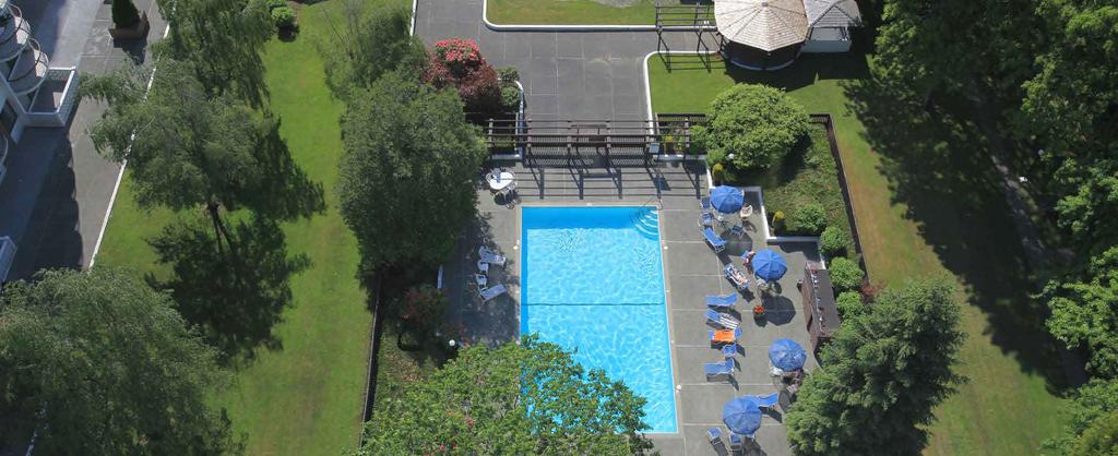
Existing Site. Ash Crescent at 57th Avenue. Ash Crescent with Low Rise. Ash Crescent with Giant Sequoias
|
|
|
- Peter Chambers
- 5 years ago
- Views:
Transcription


1 Existing Site Ash Crescent at 57th Avenue Ash Crescent with Low Rise Ash Crescent with Giant Sequoias 1


2 Existing Site Courtyard with Towers Tower Courtyard with Pool Low Rise Courtyard with Pool 2

3 Existing Site Conditions Aerial Photo Site Coverage Courtyards Tree Pattern Street Pattern Pedestrian Movement 3


4 Urban Design Concept Site Plan Site Coverage Courtyards / Major Open Space Tree Pattern Street Pattern Pedestrian Movement


 Pearson Dogwood (Approved) Langara Gardens")
5 Neighbourhood Langara Gardens will be developed as part of an emerging neighbourhood. The neighbourhood is well served by existing open space including Cambie Park, Churchill track and Langara Golf course and will be substantially enhanced by new open space on Langara Gardens as well as Pearson Dogwood. The wider neighbourhood will be supported by enhanced shopping facilities on Langara Gardens as well as new shopping opportunities on Pearson Dogwood. Langara Gardens is highly integrated into the surrounding community via pedestrian and bicycle routes. Cambie and Marine (Approved) Pearson Dogwood (Approved) Langara Gardens (Proposed) Oakridge (Approved) Cambie Street Skyline Existing Churchill Track & Field Existing Towers to be Retained Pearson Dogwood Site T Potential Canada Line Station Site Plan 5


6 Neighbourhood th Avenue Pearson Dogwood 57th Avenue Langara Gardens 5th Avenue Cambie Street Heather Street Churchill Track and Field New Neal Street Langara Gardens Cambie Street Langara Golf Course 57th Avenue th Avenue Langara Gardens 57th Avenue Pearson Dogwood 59th Avenue Heather Street Cambie Street Langara Gardens Neal Street 5th Avenue 6


7 Neighbourhood Massing Concept There are eight major principles defining the conceptual massing for Langara Gardens: The highest towers at 28-storeys are located at the centre of the site, beside the largest area of open space, thereby creating a punctuation point in the overall massing that defines the urban form. The 22-storey tower on 57th Avenue reflects the massing on the Pearson Dogwood site, relates to the existing towers on Langara Gardens and emphasizes the importance of 57th Avenue as a major transportation connection. Along the southerly Cambie Park edge the massing steps down to reduce shadowing on the Park and to provide a good human scale. Along the northern edge -6 storey buildings transition to townhouse development anticipated in the Cambie Corridor Phase 3 planning program. Along Neal Street, terraced buildings define the westerly edge of the site and allows for extensive roof top landscaping. Throughout the site 3- storey townhouses have been located to create a stronger pedestrian scale. Buildings are organized to define courtyards that will enhance neighbourly interaction. Massing throughout the site has substantial stepping to moderate the scale of buildings and provide extensive opportunities for roof top landscaping. Potential Future Canada Line Station Enhanced Retail Existing Towers to be Retained New 1 acre Park Proposed Pearson Dogwood Development Langara Golf Course Ash. St. W 59th Ave. 28 N Cambie St Ash Cres. W 5th Ave Neal St. W 57th Ave. Cambie Park Tisdall St. Heather St. Sir Wilfrid Laurier Elementary School Playground Connecting Major Open Space Sir Winston Churchill Secondary School Existing Churchill Track and Field Axonometric View from North West 7

8 Concept Concept Plan Courtyards with lush landscaping Proposed central clubhouse with a new pool, fitness centre, social lounge, meeting space, practice rooms and flex space Maintaining the character-forming trees and garden-like character of the site Potential location for a 69-space childcare centre Outdoor pools Extensive urban agriculture and edible landscaping Improvements to Cambie Park. T A new one-acre park adjacent to Churchill Track, proposed uses include fitness and sports areas, naturalized children s play area, washrooms, off-leash dog area and improved habitat Central public open space A network of multipurpose trails (bike/pedestrian pathways) connecting to the parks and green space surrounding the site Re-landscaping and reprogramming of the base of the existing towers Enhanced retail plaza and retail space (see the Enhanced Retail Board) Potential Future Canada Line Station 8

9 Concept View from North West Existing Towers to be Retained Proposed Pearson Dogwood Development Cambie Park Ash Crescent Tisdall Street W 5th Avenue Neal Street Cambie Street Existing Churchill Track and Field W 57th Avenue 9


10 View from Cambie Park Proposed Existing 10


11 View from Ash Cres. looking S Proposed Existing 11


12 View towards Cambie Park Proposed Existing 12


13 View from School Track Proposed Existing 13


14 View from Central Open Space Proposed Existing 1


15 View towards NS Open Space Proposed Existing 15


16 Enhanced Retail Retail face is pulled out approximately 10 ft. closer to 57th Avenue and Cambie Street to improve visual character and presence to the public realm. The grade level of the parking area will be dropped and adjusted to allow level access to the retail and greater accessibility. Parking area will be landscaped with pavers to improve its character and allow for multi-use space. A new south facing landscaped patio allows for people gathering and animates the corner of 57th Avenue and Cambie Street. SECTION A-A CAMBIE STREET A new connection from the retail level to the upper podium open space level to allow for enhanced pedestrian movement and greater connectivity. WEST 57TH AVENUE N Proposed Retail Site Plan Proposed Retail Section Existing Retail 16
11 GUIDING PRINCIPLES:
 11 GUIDING PRINCIPLES: CATEGORIES FIVE GUIDING PRINCIPLE CATEGORIES The Policy Statement will contain a set of Guiding Principles to inform the urban design and sustainability objectives for the site.
LANGARA GARDENS POLICY STATEMENT 2018 DRAFT
 LANGARA GARDENS POLICY STATEMENT 2018 March 2018 CONTENTS 1 2 3 4 5 6 7 8 9 \ 10 Background Vision & Guiding Principles Langara Gardens Residents Land Use & Density Urban Design Legacy & Built Form Parks,
COMMUNITY HEART HEATHER STREET LANDS
 COMMUNITY HEART PLAZA AT HARVARD, CAMBRIDGE VISUALIZATION OF THE COMMUNITY HEART FROM 33RD AVENUE The concept includes an active mix of uses around open space to support all-day vibrancy. Anchored by the
The Cambie Corridor 2015 Fall workshop series. What we heard WORKSHOP OUTLINE
 The Cambie Corridor 2015 Fall workshop series W 16 AVE Area 5 CAMBIE CORRIDOR Phase 3 What we heard ovember 21, 2015, 9am-noon, 1:30-4:30pm Peretz Centre 89 Participants* WORKSHOP OUTLIE Introductions
4 Semi-Private & Private Open Spaces
 4 Semi-Private & Private Open Spaces 4.1 Semi-private Open Space 4.1.1 Common Courtyards The common courtyards for each complex will be designed and programmed for the typical owners living there. They
Hilltop Town Garden City
 Page 1 of 14 4.1 CITY PLANNING PRECEDENTS Oakridge is a Hybrid of the positive aspects of these urban design strategies that integrate nature within the city: Hilltop Town Garden City Using topography
to the Pearson Dogwood Open House! REZONING
 PEARSN G W Rezoning pen House - February 23 & 27 WELCME to the Pearson ogwood pen House! Today s pen House: PEARSN GW Is an opportunity to share your feedback on the rezoning application REZNING submitted
Rezoning Frequently Asked Questions
 elcome The City of Vancouver has received an application to rezone 6929-6969 Cambie Street and 515 est 54th Avenue from RS-1 (Single Family) District to CD-1 (Comprehensive Development) District. The proposal
W. 54th AVE. W. 57th AVE. Pearson Dogwood Lands
 CAMBIE LANGARA GARDENS PLANNING PROGRAM INTRODUCTION WELCOME! The City, at the request of the site s owners, Peterson and Concert Properties, is undertaking a comprehensive planning program to create a
WHAT IS A POLICY STATEMENT?
 1 PURPOSE OF OPEN HOUSE PREVIOUS WHAT IS BEING CONSIDERED? Vancouver Coastal Health (VCH) would like to renew the existing facilities to meet the current and future health care needs of the community while
PEARSON OPEN HOUSE #2 QUESTIONNAIRE FEEDBACK REPORT PEARSON OPEN HOUSE #2 QUESTIONNAIRE FEEDBACK REPORT ( )
") PEARSON OPEN HOUSE #2 QUESTIONNAIRE FEEDBACK REPORT (2013 07 10) 1 INTRODUCTION SUMMARY Approximately 200 people attended the June 6 th and 8 th open houses for Pearson Dogwood Lands. The City of Vancouver
PEARSON OPEN HOUSE #2 QUESTIONNAIRE FEEDBACK REPORT (2013 07 10) 1 INTRODUCTION SUMMARY Approximately 200 people attended the June 6 th and 8 th open houses for Pearson Dogwood Lands. The City of Vancouver
Cambie Corridor Planning Program Phase Two Draft Plan. Standing Committee on City Services and Budgets May 5, 2011
 Cambie Corridor Planning Program Phase Two Draft Plan Standing Committee on City Services and Budgets May 5, 2011 Cambie Corridor Program Terms of Reference approved July 2009 Land Use Transportation Energy
THAT the Vancouver Park Board approve the proposed park concept for a new park at the Oakridge Centre redevelopment, as shown in Appendix A.
 June 26, 2018 TO: Park Board Chair and Commissioners FROM: General Manager Vancouver Board of Parks and Recreation SUBJECT: Oakridge Centre Redevelopment New Park Concept RECOMMENDATION THAT the Vancouver
Yonge Eglinton Centre Urban Design Guidelines
 Yonge Eglinton Centre Urban Design Guidelines City Planning Urban Design January 2009 YONGE EGLINTON CENTRE INTRODUCTION.................................................... 1 GENERAL SITE PLAN OBJECTIVES......................................
Urban Design Brief December 23, 2015 Southside Construction Group Official Plan & Zoning By-Law Amendment
 Urban Design Brief Proposed Official Plan & Zoning By-Law Amendment 3244, 3263 and 3274 Wonderland Road South Southside Group December 23, 2015 TABLE OF CONTENTS Page No. INTRODUCTION... 1 SECTION 1 LAND
burlington mobility hubs study Downtown Burlington Mobility Hub
 burlington mobility hubs study Downtown Burlington Mobility Hub Draft Precinct Plan Workbook PIC #3, September 7, 2017 downtown mobility hub objectives City staff and their consultants are proposing an
ELMVALE ACRES SHOPPING CENTRE MASTER PLAN
 ELMVALE ACRES SHOPPING CENTRE MASTER PLAN Contents 1.0 INTRODUCTION... 2 2.0 LOCATION... 2 3.0 EXISTING CONTEXT... 2 4.0 VISION & GUIDING PRINCIPLES... 2 5.0 LAND USE AND BUILT FORM... 4 5.1 St. Laurent
WHAT IS A POLICY STATEMENT?
 Willow Street WELCOME At the request of TransLink, the owners of the OTC (Oakridge Transit ) site, the City is undertaking a comprehensive planning program to create a Policy Statement to guide future
appendix and street interface guidelines
 appendix five: building and street interface guidelines appendix 5 building and street interface guidelines BOULEVARDS Boulevards are generally characterized by higher levels of traffic movement at higher
Yesler Terrace Explorations of Ideas 11 March 2009
 Yesler Terrace Explorations of Ideas 11 March 2009 Exploration of Ideas for Yesler Terrace Where are we in the process? Testing the Yesler Terrace Planning Program 1) How does the new Yesler Terrace feel?
Oakridge Redevelopment: New Park Concept Overview and Phase 1 Engagement Results
 Oakridge Redevelopment: New Park Concept Overview and Phase 1 Engagement Results REPORT REFERENCE Regular Park Board Meeting Monday, February 19, 2018 Purpose of Presentation To provide the Board with
[PLANNING RATIONALE] For Site Plan Control and Lifting of Holding Zone By-Law 101 Champagne Avenue. May 23, 2014
![[PLANNING RATIONALE] For Site Plan Control and Lifting of Holding Zone By-Law 101 Champagne Avenue. May 23, 2014](/thumbs/75/71599615.jpg "[PLANNING RATIONALE] For Site Plan Control and Lifting of Holding Zone By-Law 101 Champagne Avenue. May 23, 2014") [PLANNING RATIONALE] For Site Plan Control and Lifting of Holding Zone By-Law 101 Champagne Avenue May 23, 2014 Contents 1.0 Introduction... 2 2.0 Site Context... 2 2.1 Adjacent Uses... 2 Figure 1: Site
[PLANNING RATIONALE] For Site Plan Control and Lifting of Holding Zone By-Law 101 Champagne Avenue May 23, 2014 Contents 1.0 Introduction... 2 2.0 Site Context... 2 2.1 Adjacent Uses... 2 Figure 1: Site
Welcome to the Oakridge Centre Open House
 Welcome to the Oakridge Centre Open House Why is the City hosting this event? This open house is to inform you of a rezoning application submitted to the City of Vancouver to amend the existing CD-1 (Comprehensive
4 C OMMUNITY D ISTRICTS
 4 C OMMUNITY D ISTRICTS N ew development in the Area will include many different types of land uses, including a destination retail area that attracts people from all over the region; recreation opportunities
The Village. Chapter 3. Mixed Use Development Plan SPECIFIC PLAN
 The Village SPECIFIC PLAN Chapter 3 3.1 INTRODUCTION 3.1.1 Purpose This Chapter describes the development regulations applicable to the Mixed-Use and Transit Center Planning Areas. These form-based regulations
This Review Is Divided Into Two Phases:
 Semiahmoo Town Centre Review The purpose of this review: To review the Semiahmoo Town Centre Concept Plan, originally approved in 1993, to ensure that this centre will continue to serve the needs of South
Urban Design Principles
 Urban Design Principles As part of the conceptual design process, alternatives were examined with respect to a set of design principles for the project. The principles were articulated and discussed by
DEVELOPMENT PERMIT STAFF COMMITTEE REPORT JULY 4, 2012 CITY OF VANCOUVER COMMUNITY SERVICES GROUP FOR THE DEVELOPMENT PERMIT BOARD JULY 16, 2012
 CITY OF VANCOUVER COMMUNITY SERVICES GROUP DEVELOPMENT PERMIT STAFF COMMITTEE REPORT JULY 4, 2012 FOR THE DEVELOPMENT PERMIT BOARD JULY 16, 2012 8198 CAMBIE STREET (COMPLETE APPLICATION) DE415707 ZONE
INTRODUCTION TO THE CONCEPTUAL SITE PLANS
 INTRODUCTION TO THE CONCEPTUAL SITE PLANS At this stage in the planning process, we are seeking your feedback on the draft Guiding Principles and input in evaluating three conceptual site plans. Each of
WINDSOR GLEN DESIGN GUIDELINES
 WINDSOR GLEN DESIGN GUIDELINES Adopted by Council, 2006 WINDSOR GLEN REDEVELOPMENT DESIGN GUIDELINES August 2006 1.0 Master Plan Organization For this area of the Coquitlam Town Centre, a mix of high,
1354 CARLING AVENUE FORMAL RESUBMISSION HOLLOWAY LODGING
 1354 CARLING AVENUE FORMAL RESUBMISSION HOLLOWAY LODGING DECEMBER, 2017 THE SITE 1354 CARLING AVENUE The subject property is at a key gateway to the Carlington Neighbourhood, and when combined with future
OPEN SPACE TYPES. SIZE 8 acres. SIZE 20 acres. SIZE 1 acre
 TYPICAL CHARACTERISTICS OPEN SPACE TYPES OPEN SPACE TYPES The neighborhood contains an extensive variety of open space types. Most of these spaces incorporate multiple uses and activities, so that each
TSAWWASSEN TOWN CENTRE REDEVELOPMENT BLOCK A 004
 Current Context The context for the project includes storey multi-family residential to the northwest, a TD bank immediately north, highway oriented commercial to the east, a surface parking lot to the
(DC1) Direct Development Control Provision DC1 Area 4
 Direct Development Control Provision DC1 Area 4") . General Purpose (DC) Direct Development Control Provision DC Area 4 The purpose of this Provision is to provide for an area of commercial office employment and residential development in support of the
. General Purpose (DC) Direct Development Control Provision DC Area 4 The purpose of this Provision is to provide for an area of commercial office employment and residential development in support of the
URBAN DESIGN BRIEF URBAN DESIGN BRIEF 721 FRANKLIN BLVD, CAMBRIDGE August 2018
 URBAN DESIGN BRIEF URBAN DESIGN BRIEF 721 FRANKLIN BLVD, CAMBRIDGE August 2018 DESIGN BRIEF CONTENTS PART A 1.0 INTRODUCTION 2.0 DESCRIPTION & ANALYSIS OF SITE CONTEXT 3.0 DESIGN CONSTRAINTS AND OPPORTUNITIES
Key Moves in the Plan
 Key Moves in the Plan 2 Add housing that fits the neighbourhood s character Make it easier to leave the car behind Oak Bay Avenue Village plan to be completed in future planning process Future active transportation
Rezoning Information booklet 6600 Cambie Street
 Rezoning Information booklet 6600 Cambie Street December 2013 CONTENTS page Vision 2 Site and Context Context Plan 3 Context Images 4 Proposal Building Design 5-8 Sustainability/Livability 9-10 Landscape
Little Mountain UDP Presentation
 Summary of UDP Evaluation of Dec 2015 Plan Dec 2015 Site Plan Transitional edges work well Central spine and permeability are strong Tree retention is good Establish Big Idea Sameness of built form contributes
Planning Board Briefing
 Planning Board Briefing Why Now? The Sector Plan Implementation Chapter States: Before Stage 1 begins, the following must occur: Approval of the Sectional Map Amendment. Approval of the Greater Lyttonsville
CITY OF VANCOUVER POLICY REPORT DEVELOPMENT AND BUILDING
 CITY OF VANCOUVER P7 POLICY REPORT DEVELOPMENT AND BUILDING Report Date: July 8, 2008 Author: Kirsten Robinson / Matt Shillito Phone No.: 604.871.6889 / 604.871.6431 RTS No.: 07255 VanRIMS No.: 08-2000-20
Workshop 3. City of Burlington Waterfront Hotel Planning Study. September 14, The Planning Partnership
 Workshop 3 City of Burlington Waterfront Hotel Planning Study September 14, 2017 The Planning Partnership The Waterfront Hotel Planning Study 01 The Brant & Lakeshore Planning Study will establish a Strategic
Landscape Site Plan BLOCK D BLOCK A BLOCK C BLOCK B DEC 2009 L A N E W AY ARBUTUS 2 MEWS ARBUTUS STREET YEW STREET EXTENSION LEGEND
 Landscape Site Plan Green Edges Arbutus Mews Public Square Urban Garden Courts Green Roofs City Homes Private Patios Private Roof Terraces Urban Agriculture Plots BLOCK D BLOCK C YEW STREET EXTENSION L
Clairtrell Area Context Plan
 Clairtrell Area Context Plan March 2005 Urban Development Services City Planning Contents 1. Introduction... 4 2. Development Structure... 6 2.1 Streets... 7 2.1.1 Sheppard Avenue and Bayview Avenue...
The Master Plan Framework
 The Master Plan Framework The East Harbour Master Plan advances the development of 60 acres of former industrial lands east of the Don River. The Master Plan outlines a vision for a vibrant, transit-oriented
Welcome. Walk Around. Talk to Us. Write Down Your Comments
 Welcome This is an information meeting introducing the applications for proposed redevelopment of the Yorkdale Shopping Centre site at 3401 Dufferin Street and 1 Yorkdale Road over the next 20+ years,
URBAN DESIGN BRIEF. Saginaw Subdivision 124 SAGINAW PARKWAY, CAMBRIDGE OCTOBER 2015 OUR FILE 1422A
 URBAN DESIGN BRIEF Saginaw Subdivision 124 SAGINAW PARKWAY, CAMBRIDGE OCTOBER 2015 OUR FILE 1422A Contents 1.0 INTRODUCTION AND SITE DESCRIPTION... 1 2.0 MUNICIPAL DESIGN DIRECTION... 7 3.0 MASTER CONCEPT
HIGHLAND VILLAGE GREEN URBAN DESIGN PRINCIPLES/GUIDELINES
 URBAN DESIGN GUIDING PRINCIPLES/GUIDELINES CONTEXT/CHARACTER The City of Calgary s Municipal Development Plan (MDP), Transit-Oriented Development (TOD) Policy Guidelines and Main Street/Corridor policy
Tel: (705) Fax: (705)
 Fax: (705)") 521 and 525 Essa Road City of Barrie Tel: (705) 812-3281 Fax: (705) 812-3438 Email: INFO@IPSCONSULTINGINC.com 1 5 0 D U N L O P S T R E E T E A S T, S U I T E 2 0 1, B A R R I E O N T A R I O L 4 M 1 B
521 and 525 Essa Road City of Barrie Tel: (705) 812-3281 Fax: (705) 812-3438 Email: INFO@IPSCONSULTINGINC.com 1 5 0 D U N L O P S T R E E T E A S T, S U I T E 2 0 1, B A R R I E O N T A R I O L 4 M 1 B
Lehigh Acres Land Development Regulations Community Planning Project
 Lehigh Acres Land Development Regulations Planning Effort Summary In July, 2010 Commissioner Frank Mann invited the Lehigh Acres community to start discussing how to achieve their recently adopted community
3 Parks, Open Spaces and the Public Realm
 3 Parks, Open Spaces and the Public Realm 3.1 Open Spaces and Public Places Pearson Dogwood Policy Statement Open Spaces and Public Places A legible, welcoming and sustainable open space system will be
EcoVerde MADISON TO DOWNTOWN TO BEACH. Legend Highway Major Connection Major Street Local Street Proposed Access. Response to Tropicana Field RFP
 EcoVerde TO BEACH 275 16th Street North 16th Street South 13th Street North 13th Street South 11th Street North 11th Street South 1st Avenue North Central Avenue 1st Avenue South TO DOWNTOWN 2nd Avenue
AvalonBay Communities + BRIDGE Housing. Mission Housing Habitat for Humanity Pacific Union Development Corporation
 AvalonBay Communities + BRIDGE Housing Mission Housing Habitat for Humanity Pacific Union Development Corporation Tonight s Agenda Recap of discussion from last CAC meeting Updates on meetings with Stakeholders
Planning Rationale Zoning By-law Amendment Application October Centrepointe Drive - Ottawa, Ontario
 ZONING BYLAW AMENDMENT OCTOBER 2011 Table of Contents Table of Contents... i 1 Introduction... 1 1.1 Site Location... 1 1.2 Overview of Proposed Development... 1 2 Context... 6 2.1 Community Character...
1. POPLAR LANDING + MUNI EVERS PARK
 . POPLAR LANDING + MUNI EVERS PARK WHAT S HAPPENING? PROJECT DESCRIPTION PROJECT TIMELINE Poplar Landing and the future Muni Evers Park site (located at 00 Quayside Drive) is jointly owned by the City
Buildings may be set back to create small plazas provided that these setbacks do not substantially disrupt the street wall s continuity.
 6-22 Community Design Street Walls and Street-front Setbacks The siting of buildings will play a critical role in establishing the character and sense of place for the District. Siting buildings at the
MAIN STREET DESIGN GUIDELINES CONTEXT
 MAIN STREET DESIGN GUIDELINES CONTEXT VISION The re-imagining of Main Street offers an unparalleled opportunity to strengthen and link Fredericton North through the integration of local neighbourhoods,
Schedule B to Report PLS
 Page 25 Q1. The land use concept is made up of many different land uses (residential, commercial, parks, schools, environmental areas etc.) A number of land uses are concentrated in the Community Core,
Urban Design Brief Fanshawe Park Road. Competition Toyota
 Urban Design Brief 1300 Fanshawe Park Road Competition Toyota May 2, 2014 TABLE OF CONTENTS Page No. INTRODUCTION... 1 SECTION 1 LAND USE PLANNING CONTEXT... 1 1.1 The Subject Lands... 1 1.2 The Proposal...
4. Parks, Open Space and Waterways
 4. s, Open Space and Waterways Other Relevant Policies & Bylaws Official Community Plan s and Open Spaces Master Plan ways Plan Management and Improvement Plans Goals: 1. Protect and enhance Vic West s
LAKEVIEW VILLAGE VISION & MASTERPLAN PRESENTATION TO CITY OF MISSISSAUGA. April 9, 2018
 LAKEVIEW VILLAGE VISION & MASTERPLAN PRESENTATION TO CITY OF MISSISSAUGA April 9, 2018 AGENDA Introduction Vision Plan Comparison The Big Moves Trail Connections Plan Overview Districts Conveyance Comparison
TALL BUILDING GUIDELINES
 TALL BUILDING GUIDELINES Urban Design Guidance for the Site Planning and Design of Tall Buildings in Milton May, 2018 A Place of Possibility Contents 1.0 INTRODUCTION 1 1.1 What is a Tall Building? 2
Revitalization Guidelines for Corridors, Villages and Town Centres
 Revitalization Guidelines for Corridors, Villages and Town Centres July 2017 Updated May, 2018 Publishing Information Title: Prepared by: Revitalization Guidelines for Corridors, Villages and Town Centres
Community Information Meeting
 Queensborough Eastern Community Information Meeting July 24, 2014 Cameron Chalmers, MCIP, RPP Platform Properties Meeting Format Purpose Format The purpose of the meeting is to invite the community to
Langara College. Policy Statement (DRAFT)
") APPENDIX B City of Vancouver Land Use and Development Policies and Guidelines Community Services, 453 W. 12 th Ave, Vancouver, BC V5Y tel 604.873.7344 fax 873.7060 planning@city.vancouver.bc.ca Langara
APPENDIX B City of Vancouver Land Use and Development Policies and Guidelines Community Services, 453 W. 12 th Ave, Vancouver, BC V5Y tel 604.873.7344 fax 873.7060 planning@city.vancouver.bc.ca Langara
New Park / Entry Court & Plaza Concept Design
 New Park / Entry Court & Plaza Concept Design The SECC Public realm is proposed to have a focus on health, wellness, and community and that site users will include patrons of the neighbourhood. The block
4.1.3 LAND USE CATEGORIES
 4.1.3 LAND USE CATEGORIES a. City Center District The City Center District incorporates the existing character and mix of uses in downtown Belmont to encourage redevelopment and new development in keeping
Queensborough Eastern Neighbourhood Node. Community Open House
 Queensborough Eastern Community Open House The Vision The Queensborough Eastern will become the heart of eastern Queensborough. Through a sensitive mix of viable commercial and residential areas, the neighbourhood
Multi family Residential Development Permit Area
 City of Kamloops KAMPLAN Multi family Residential Development Permit Area PURPOSE The purpose of this Development Permit Area (DPA) is to establish objectives and provide guidelines for the form and character
CONTENTS 8.0 LAND USE 8.1 GENERAL LAND USE 8.2 RESIDENTIAL 8.3 MIXED USE 8.4 COMMERCIAL 8.5 EMPLOYMENT LANDS
 8-2 Land Use 8.0 LAND USE CONTENTS 8.1 GENERAL LAND USE 8.1.1 Uses provided for in all Land Use Designations 8.1.2 Uses prohibited in Hazardous Lands, Hazardous Sites and Special Policy Areas 8.1.3 Uses
HOUSING ACHIEVING HOUSING DIVERSITY & AFFORDABILITY IN THE CORRIDOR
 HOUSING ACHIEVING HOUSING DIVERSITY & AFFORDABILITY IN THE 1.0 Broadening the supply and mix of housing options in the Cambie Corridor will help improve affordability and foster social and economic well-being
City of Vancouver Land Use and Development Policies and Guidelines
 City of Vancouver Land Use and Development Policies and Guidelines Planning and Development Services, 453 W. 12th Ave Vancouver, BC V5Y 1V4 tel 604.873.7344 fax 604.873.7060 planning@vancouver.ca LANGARA
Uptown Rideau Street Secondary Plan [Amendment #166, January 12, 2016]
![Uptown Rideau Street Secondary Plan [Amendment #166, January 12, 2016]](/thumbs/76/73760497.jpg "Uptown Rideau Street Secondary Plan [Amendment #166, January 12, 2016]") [Amendment #166, January 12, 2016] The policies of this Secondary Plan are in effect, save and except for the property at 560 Rideau Street, for which there remains a site specific appeal to this Secondary
[Amendment #166, January 12, 2016] The policies of this Secondary Plan are in effect, save and except for the property at 560 Rideau Street, for which there remains a site specific appeal to this Secondary
8. Urban Villages. Other Relevant Policies & Bylaws Official Community Plan Development Permit Area Designations and Guidelines
 8. Urban Villages Urban villages provide walkable shops and services, encourage a neighbourhood social life, create a sense of place and provide different housing options. More housing near Urban Villages
Metro. Activity Center Design Guidelines. Recommendations For Developing Focused, Mixed-Use Commercial/Residential Centers
 Metro Activity Center Design Guidelines Recommendations For Developing Focused, Mixed-Use Commercial/Residential Centers Metro Activity Centers What is a MAC? Legacy, the adopted guide for the future growth
Description of Preferred Alternative
 Chapter 2 Description of Preferred Alternative 2.1 Introduction This chapter of the programmatic Sammamish Town Center Sub-area Plan Final EIS provides a more detailed description of the Preferred Alternative
DOWNTOWN GEORGETOWN PLANNING STUDY
 DOWNTOWN GEORGETOWN PLANNING STUDY Community Workshop #3 Thursday, May 4, 08 The Planning Partnership OVERVIEW OF STUDY, PROCESS & MILESTONES We are here PURPOSE OF THE STUDY To develop a clear vision
Edmonton Design Committee Formal Submission: Rezoning October 16, ICE District Tower Lighting AED Zone Amendment
 Edmonton Design Committee Formal Submission: Rezoning October 16, 2018 ICE District Tower Lighting AED Zone Amendment 1 Table of Contents 01 Project Description 3 02 Context 4 03 Project Data 5 04 Proposed
BESSARION-LESLIE CONTEXT PLAN
 Development in the Bessarion-Leslie area will be consistent with the following urban design guidelines. They provide a framework for development in the area and are to be read in conjunction with the urban
DRAFT Northeast Quadrant of Kipling Avenue and Highway 7 DRAFT AUGUST 29, Goals Land Use. The goals of this Plan are to:
 AUGUST 29, 2017 12.15 Northeast Quadrant of Kipling Avenue and Highway 7 12.15.1 Goals 12.15.2 Land Use The goals of this Plan are to: 12.15.2.1 General Provisions: a) Ensure the development of a compact
Regency Developments. Urban Design Brief. Holyrood DC2 Rezoning
 Regency Developments Urban Design Brief Holyrood DC2 Rezoning Stantec Consulting Ltd. 7-31-2017 1. Overview Regency Developments intends to rezone the lands located at 8510 and 8511 93 Avenue, within the
URBAN DESIGN BRIEF. 2136&2148 Trafalgar Road. Town of Oakville
 URBAN DESIGN BRIEF 2136&2148 Trafalgar Road Town of Oakville Prepared By: METROPOLITAN CONSULTING INC For 2500674 Ontario Inc November 2016 TABLE OF CONTENTS Page No. 1.0 Introduction/Description of Subject
Shared Principles and Emerging Plan Directions
 Shared Principles and Emerging Plan Directions Introduction Since the Fairfield Neighbourhood planning process launched in June 2016, we have heard from many residents, businesses, groups and other people
for a context-sensitive design that connects to its surroundings.
 5 Built Form Figure 5-: Parcels and Buildings 33RD AVE. 5. Block and Building Design Concept Block, parcel, and building design in Little Mountain is based largely on the public realm concept, and the
PLANNING RATIONALE FOR THE PROPOSED RIVERSIDE SOUTH ELEMENTARY SCHOOL 715 BRIAN GOOD AVENUE, OTTAWA, ON
 PLANNING RATIONALE FOR THE PROPOSED RIVERSIDE SOUTH ELEMENTARY SCHOOL 715 BRIAN GOOD AVENUE, OTTAWA, ON Conseil des écoles publiques de l'est de l'ontario (CEPEO) French Public School Board TABLE OF CONTENTS
Public Consultation Summary: Lakeview Place Making Workshop January 30, 2008.
 Page 1 of 11 Public Consultation Summary: Lakeview Place Making Workshop January 30, 2008. 1.0 Introduction: On January 30, 2008 the City of Mississauga, in conjunction with the consulting team of Brook
SECTION ONE: INTRODUCTION. introduction
 introduction 1 INTRODUCTION Since it was first established in 1843 as a trading post for the Hudson s Bay Company, Victoria has evolved into a Provincial capital city that is recognized across Canada and
2900 Steeles Avenue East at Don Mills Road in the Town of Markham
 STAFF REPORT INFORMATION ONLY 2900 Steeles Avenue East at Don Mills Road in the Town of Markham Date: January 23, 2008 To: From: Wards: Reference Number: North York Community Council Director, Community
3.1 Existing Land Use
 3.0 Land Use This strategy has been developed taking into account the position of the Town of Sidney as the economic center of the Saanich Peninsula. It acknowledges existing land use patterns in the downtown
From: Director, Community Planning, Etobicoke York District
 STAFF REPORT ACTION REQUIRED 4208, 4210 and 4214 Dundas Street West - Official Plan Amendment and Zoning By-law Amendment Application - Preliminary Report Date: July 22, 2014 To: Etobicoke York Community
Community Co-Design Process. Create the ability to house a large school on the Cubberley site in the future.
 Community Co-Design Process Create the ability to house a large school on the Cubberley site in the future. Process timeline Programming Phase Design Phase M1 Program Needs & Major Spatial Relationships
New-Cast Mixed-use Development Proposal King Street West, Newcastle, Ontario
 URBAN DESIGN BRIEF New-Cast Mixed-use Development Proposal King Street West, Newcastle, Ontario TABLE OF CONTENTS: 1.0 Executive Summary 2.0 Creating Vibrant and Sustainable Urban Places: Excerpts from
3.0 URBAN DESIGN. December 6, OVERVIEW
 Urban Design 3.0 URBAN DESIGN December 6, 2007 3.1 OVERVIEW The highly urban character of Easton Place is defined by the overall design of the community. The following sections provide an overview of the
Urban Design Principles
 Urban Design Principles 3.0 Harbouside Waterfront Rezoning Submission - November 2012 3.1 Urban Design Principles Twelve distinct design principles have been identifi ed for the Harbourside Waterfront
Report Date: January 28, 2014 Contact: Matt Shillito Contact No.: RTS No.: VanRIMS No.: Meeting Date: February 4, 2014
 ADMINISTRATIVE REPORT Report Date: January 28, 2014 Contact: Matt Shillito Contact No.: 604.871.6431 RTS No.: 10327 VanRIMS No.: 08-2000-20 Meeting Date: February 4, 2014 TO: FROM: SUBJECT: Vancouver City
This Appendix includes foundational work that will help inform a more detailed public benefits strategy for the Cambie Corridor.
 APPENDIX B PAGE 1 of 11 APPENDIX B: Draft Public Benefits Analysis Appendix B provides a high level overview of the long term population projections for the Cambie Corridor, current levels of public benefits
URBAN DESIGN PANEL MINUTES ITEMS REVIEWED AT THIS MEETING
 URBAN DESIGN PANEL MINUTES DATE: May 6, 2015 TIME: PLACE: PRESENT: REGRETS: RECORDING SECRETARY: 4.00 pm Town Hall Meeting Room, City Hall MEMBERS OF THE URBAN DESIGN PANEL: Russell Acton Stefan Aepli
Sketch Plan. MNCPPC Plan No: A
 General Notes 1. The Sketch Plan drawings are conceptual only and represent proposed development in an illustrative manner. Final building locations, dimensions, heights, uses and development standards
Official Community Plan Bylaw No. 4360, 2004, Amendment Bylaw No. 4897, 2016 (Sewell s Landing)
") District of West Vancouver Official Community Plan Bylaw No. 4360, 2004, Amendment Bylaw No. 4897, 2016 (Sewell s Landing) Effective Date: 1089612v1 District of West Vancouver Official Community Plan Bylaw
District of West Vancouver Official Community Plan Bylaw No. 4360, 2004, Amendment Bylaw No. 4897, 2016 (Sewell s Landing) Effective Date: 1089612v1 District of West Vancouver Official Community Plan Bylaw
Context Plan and Urban Design Guidelines for the lands west of Provost Drive
 Concord Park Place Context Plan and Urban Design Guidelines for the lands west of Provost Drive Amendment to the Bessarion-Leslie Context Plan October 2013 Concord Park Place Urban Design Guidelines The
Town Center. Block 5 Existing multifamily residential units are expected to remain.
 Area Guidelines Germantown s districts should be developed as distinct communities with unique features that are supported through the guidelines. The guidelines not only help distinguish these districts