MONTGOMERY COUNTY PLANNING DEPARTMENT THE MARYLAND-NATIONAL CAPITAL PARK AND PLANNING COMMISSION
|
|
|
- Shannon Chandler
- 5 years ago
- Views:
Transcription


 of development.")
1 MONTGOMERY COUNTY PLANNING DEPARTMENT THE MARYLAND-NATIONAL CAPITAL PARK AND PLANNING COMMISSION Solera Reserve Kensington: Preliminary Plan No and Site Plan No MCPB Item No. Date: 12/20/18 Description Request to create one lot and redevelop the property with a maximum of 138,855 square feet of development, with up to 1,000 square feet of commercial uses, up to 137,855 square feet of residential uses (including 12,662 sf of MPDU bonus density based on 15% MPDUs) for 63 Independent Living units and 79 Residential Care beds, residential amenities, and structured parking. Location: Southwest corner of the intersection of Metropolitan Avenue and St. Paul Street, Kensington Master Plan: 2012 Kensington Sector Plan, & St. Paul Street designated Historic in Kensington Master Plan Historic District. Zone: CRT-1.5 C-1.5 R-1.5 H-60. Property Size: 1.93 acres. Acceptance Date: June 26, Applicant: SM Kensington Senior Living RE, LLC. Review Basis: Chapter 50, Chapter 59, Chapter 22A. Summary Emily Tettelbaum, Planner Coordinator, Area 2 Division, emily.tettelbaum@montgomeryplanning.org, Rhoda Hersson-Ringskog, Senior Planner, Area 2 Division, Rhoda.Hersson-Ringsk@montgomeryplanning.org, Patrick Butler, Supervisor, Area 2 Division, patrick.butler@montgomeryplanning.org, Carrie Sanders, Chief, Area 2 Division, carrie.sanders@montgomeryplanning.org, Completed: 12/10/18 Staff recommends approval of Preliminary Plan No and Site Plan No with conditions. On May 3, 2018, the Planning Board approved Sketch Plan No for a mixed-use project with up to 126,193.5 square feet (without MPDU bonus density) of development. Proposed redevelopment of the site under the Optional Method of Development with Independent Living Facility for Seniors/Residential Care Facility. A minimum of 15% of the Independent Living units will be Moderately Priced Dwelling Units (MPDUs). The Site Plan approval includes approval of the Final Forest Conservation Plan. The proposal will retain two existing historic buildings located within the Kensington Master Plan Historic District, and adaptively reuse them to provide for up to 1,000 square feet of retail/service use. The Historic Preservation Commission (HPC) supports the proposed redevelopment.
2 TABLE OF CONTENTS SECTION 1: RECOMMENDATIONS AND CONDITIONS 3 Preliminary Plan Site Plan SECTION 2: VICINITY AND SITE DESCRIPTION 11 Site Vicinity Site Description SECTION 3: PROJECT DESCRIPTION 14 Previous Approvals Proposal SECTION 4: COMMUNITY CORRESPONDENCE 21 SECTION 5: PRELIMINARY PLAN ANALYSIS AND FINDINGS SECTION 6: SITE PLAN ANALYSIS AND FINDINGS SECTION 7: CONCLUSION ATTACHMENTS 1. Preliminary Plan 2. Site Plan 3. Landscape Plan 4. Correspondence from Town of Kensington 5. Community Correspondence 6. MCDPS Water Resources Section Letter 7. MCDPS Fire Department Access and Water Supply Section letter 8. DHCA Letter 9. MCDOT Letter 10. Final Forest Conservation Plan 11. Forest Conservation Variance 12. Historic Preservation Commission Letter Page 2
3 SECTION 1: RECOMMENDATIONS AND CONDITIONS Preliminary Plan No Staff recommends approval of Preliminary Plan No , including the Preliminary Forest Conservation Plan. All site development elements shown on the latest electronic version as of the date of this Staff Report submitted via eplans to the M-NCPPC are required except as modified by the following conditions: General Approval 1. Density This Preliminary Plan is limited to one lot for a maximum of 138,855 square feet of development including up to 1,000 square feet of commercial uses and up to 137,855 square feet of residential uses (including 12,662 sf of MPDU bonus density based on 15% MPDUs) for 63 Independent Living units and 79 Residential Care beds. 2. Sketch Plan Conformance The Applicant must comply with the conditions of the Planning Board s approval for Sketch Plan No Adequate Public Facilities and Outside Agencies 3. Adequate Public Facilities The Adequate Public Facility (APF) review for the Preliminary Plan will remain valid for sixty (61) months from the date of mailing of this Planning Board Resolution. 4. Outside Agencies a) Except for Condition #5, the Planning Board accepts the recommendations of the Montgomery County Department of Transportation (MCDOT) in its letter dated July 16, 2018 and incorporates them as conditions of the Preliminary Plan approval. Except for Condition #5, the Applicant must comply with each of the recommendations as set forth in the letter, which may be amended by MCDOT if the amendment does not conflict with any other conditions of the Preliminary Plan approval. b) Before the issuance of access permits, the Applicant must satisfy the Maryland State Highway Administration s (MDSHA) requirements for access and improvements to Metropolitan Avenue. c) The Planning Board accepts the recommendations of the Montgomery County Department of Permitting Services (MCDPS) Water Resources Section in its stormwater management concept letter dated October 29, 2018, and incorporates them as conditions of the Preliminary Plan approval. The Applicant must comply with each of the recommendations as set forth in the letter, which may be amended by MCDPS Water Resources Section if the amendment does not conflict with any other conditions of the Preliminary Plan approval. d) The Planning Board accepts the recommendations of the Montgomery County Department of Housing and Community Affairs (DHCA), in its letter dated November 1, 2018, and incorporates them as conditions of approval. The Applicant must comply with each of the recommendations as set forth in the letter, which DHCA may amend if the amendment does not conflict with other conditions of Preliminary Plan approval. Page 3
4 e) The Planning Board accepts the recommendations of the Montgomery County Department of Permitting Services (MCDPS), Fire Department Access and Water Supply Section in its letter dated December 7, 2018 and incorporates them as conditions of approval. The Applicant must comply with each of the recommendations as set forth in the letter, which MCDPS may amend if the amendment does not conflict with other conditions of Preliminary Plan approval. 5. Site Plan Approval a) Before clearing or grading the Subject Property, the Applicant must receive Staff certification of Site Plan No The number and location of site elements including but not limited to buildings, dwelling units, on-site parking, site circulation, and sidewalks is determined through site plan review and approval. b) If an approved site plan amendment for the Subject Property substantially modifies the lot or right-of-way configuration shown on this Preliminary Plan, the Applicant must obtain approval of a Preliminary Plan amendment before certification of the site plan amendment. Environment 6. Forest Conservation a) The Applicant must comply with Final Forest Conservation Plan b) Prior to Certified Site Plan, the Applicant must revise the Preliminary Forest Conservation Plan to revise calculations that include mitigations for Tree #01 and show mitigation plantings for the removal of Tree #02. Transportation 7. Frontage Improvements a) The Applicant must provide a dedication of thirty-five (35) feet from the existing pavement centerline along the Subject Property frontage on Metropolitan Avenue and show this dedication on the record plat. b) The Applicant must construct an eight (8)-foot-wide sidepath along the Property s Metropolitan Avenue frontage. Record Plats and Certified Preliminary Plan 8. Record Plats a) There shall be no clearing or grading of the site prior to recordation of plat(s). b) The record plat must show necessary easements. c) The record plat must reflect all areas under common ownership. 9. Certified Preliminary Plan Before approval of the Certified Preliminary Plan, the following revisions must be made subject to Staff review and approval: a) Include all applicable agency approval letters and the Preliminary Plan Resolution on the approval sheet(s). b) Show the location of a public improvement easement over the portion of public parking along St Paul Street that is located on the Property. c) Include the following note: Page 4
5 Unless specifically noted on this plan drawing or in the Planning Board conditions of approval, the building footprints, building heights, on-site parking, site circulation, and sidewalks shown on the Preliminary Plan are illustrative. The final locations of buildings, structures and hardscape will be determined at the time of site plan approval. Please refer to the zoning data table for development standards such as setbacks, building restriction lines, building height, and lot coverage for each lot. Page 5
6 Site Plan No Staff recommends approval of Site Plan The Applicant must comply with the binding elements and conditions of approval for Sketch Plan as listed in the MCPB Resolution No dated May 3, 2018, and Preliminary Plan No All site development elements shown on the latest electronic version as of the date of this Staff Report submitted via eplans to the M-NCPPC are required except as modified by the following conditions. 1 Density, Height & Housing 1. Density The Site Plan is limited to a maximum of 138,855 square feet of development on the Subject Property including up to 1,000 square feet of commercial uses and up to 137, 855 square feet of residential uses (including 12,662 sf of MPDU bonus density based on 15% MPDUs) for 63 Independent Living units and 79 Residential Care beds. 2. Height The development is limited to a maximum height of 60 feet, as measured from the building height measuring point, as illustrated on the Certified Site Plan. Open Space, Facilities and Amenities 3. Public Open Space, Facilities, and Amenities a) The Applicant must provide a minimum of 3,600 square feet of Public Open Space (5.2% of net lot area) on-site. b) All landscaping must be installed within one growing season of the issuance of the Final Use and Occupancy Certificate. c) Before issuance of the Final Use and Occupancy Certificate for the residential building: i. The Applicant must construct the streetscape improvements shown on the Certified Site Plan, including the undergrounding of utilities, along the Property s Metropolitan Avenue frontage on; and ii. All Public Open Spaces on the Subject Property must be completed. d) Prior to Building Permit, the Applicant must make a contribution to the Bikeshare Program, subject to review and approval by MCDOT. 4. Public Benefits The Applicant must provide the following public benefits and meet the applicable criteria and requirements of the Zoning Ordinance and the CR Zone Incentive Density Implementation Guidelines for each one. a) Transit Proximity to the Marc Rail Station. b) Connectivity between Uses, Activities, and Mobility Options i. Minimum Parking The Applicant may not construct more than 78 off street parking spaces. c) Diversity of Uses and Activities 1 For the purposes of these conditions, the term Applicant shall also mean the developer, the owner or any successor (s) in interest to the terms of this approval. Page 6
7 i. Affordable Housing/MPDUs a. The development must provide a minimum of 15 percent MPDUs, or a Department of Housing and Community Affairs (DHCA) approved equivalent, consistent with the requirements of Chapter 25A. b. Before issuance of any building permit for any residential unit, an MPDU agreement between the Applicant and DHCA that satisfies the requirements of Chapter 25A must be executed. ii. Enhanced Accessibility for the Disabled The Applicant must construct at least two dwelling units that satisfy American National Standards Institute A117.1 Residential Type A standards or an equivalent County standard. d) Quality Building and Site Design Structured Parking The Applicant must provide all 78 off street parking spaces within a below-grade structure. e) Building Reuse Before issuance of any building permit, the Applicant must submit documentation to M- NCPPC Staff showing compliance with the Retained Building criteria in Section G. 5. Recreation Facilities Prior to the Final Use and Occupancy Certificate for the residential building, the Applicant must provide the recreation facilities as shown on the Certified Site Plan. 6. Maintenance of Public Amenities The Applicant is responsible for maintaining all publicly accessible amenities including, but not limited to, the public plaza, seating and landscaping in the Public Open Space. Environment 7. Forest Conservation a) The Applicant must comply with Final Forest Conservation Plan No b) Prior to the start of any clearing, grading, or demolition occurring on the Subject Property, the Applicant must pay the fee-in-lieu to satisfy the.30 acres of afforestation required. c) Prior to the release of the first Use and Occupancy Certificate, the Applicant must provide mitigation for the removal of one (1) tree subject to the variance provision by planting native canopy trees totaling thirteen (13) caliper inches, with a minimum planting stock size of three (3) caliper inches. The trees must be planted on the Subject Property, outside any rights-of-way, or utility easements, including stormwater management easements. Adjustments to the planting locations of these trees is permitted with the approval of the M-NCPPC forest conservation inspector. d) The limits of disturbance ( LOD ) on the Final Sediment and Erosion Control Plan must be consistent with the LOD shown on the approved Final Forest Conservation Plan. e) The Applicant must comply with all tree protection and tree save measures shown on the approved Final Forest Conservation Plan. Tree protection measures not specified on the approved Forest Conservation Plan may be required by the M-NCPPC forest conservation inspector. f) The Final Sediment Control Plan must be consistent with the final limits of disturbance shown on the approved Final Forest Conservation Plan. Page 7
8 g) Prior to Certified Site Plan, the Applicant must revise the Final Forest Conservation Plan to revise calculations that include mitigations for Tree #01 and show mitigation plantings for the removal of Tree # Noise Attenuation a) If the plan changes in any manner that affects the validity of the noise analysis dated May 22, 2018, for acoustical certifications and noise attenuation features, the Applicant must conduct a new noise analysis to reflect the revised plans, and new noise attenuation features may be required. b) Before issuance of any Use and Occupancy Certificate for any residential unit, the Applicant must construct the noise barrier along the Property s southern lot line and certify that the noise impacted units have been constructed in accordance with the certification of an engineer that specializes in acoustical treatments. 9. Historic Preservation The Planning Board accepts the recommendations of the Historic Preservation Commission (HPC) in its letter dated December 7, 2018 and incorporates them as conditions of Site Plan approval. The Applicant must comply with each of the recommendations as set forth in the letter. Transportation & Circulation 10. Pedestrian & Bicycle Circulation a) The Applicant must provide sixteen (16) long-term and four (4) short-term bicycle parking spaces. b) The long-term spaces must be in a secured, well-lit bicycle room adjacent to the covered parking area, and the short-term spaces must be inverted-u racks (or approved equal) installed in well-lit area adjacent to the commercial space (weather protected preferred). The specific location(s) of the short-term bicycle rack(s) must be identified on the Certified Site Plan. c) Before issuance of the Final Use and Occupancy Certificate, the Applicant must provide an eight (8)-foot-wide sidepath with and a seven (7)-foot wide green panel along the Property s Metropolitan Avenue frontage. Site Plan 11. Site Design The exterior architectural character, proportion, materials, and articulation must be substantially similar to the schematic elevations in the Certified Site Plan. 12. Lighting a) Prior to certified Site Plan, the Applicant must provide certification to Staff from a qualified professional that the exterior lighting in this Site Plan conforms to the latest Illuminating Engineering Society of North America (IESNA) recommendations (Model Lighting Ordinance- MLO: June 15, 2011, or as superseded) for a development of this type. All onsite exterior area lighting must be in accordance with the latest IESNA outdoor lighting recommendations (Model Lighting Ordinance-MLO: June 15, 2011, or as superseded). b) All onsite down-lights must have full cut-off fixtures. Page 8
9 c) Deflectors will be installed on all fixtures to prevent excess illumination and glare. d) Illumination levels generated from on-site lighting must not exceed 0.5 footcandles (fc) at any property line abutting public roads and residentially developed properties. e) Streetlights and other pole-mounted lights must not exceed the height illustrated on the Certified Site Plan. 13. Site Plan Surety and Maintenance Agreement Prior to issuance of any building permit, sediment control permit, or Use and Occupancy Certificate, the Applicant must enter into a Site Plan Surety and Maintenance Agreement with the Planning Board in a form approved by the M-NCPPC Office of General Counsel that outlines the responsibilities of the Applicant. The Agreement must include a performance bond(s) or other form of surety in accordance with Section K.4 of the Montgomery County Zoning Ordinance, with the following provisions: a) A cost estimate of the materials and facilities, which, upon Staff approval, will establish the surety amount. b) The cost estimate must include applicable Site Plan elements, including, but not limited to the noise wall, plant material and soil medium, on-site lighting, indoor and outdoor recreational facilities, site furniture, trash enclosures, retaining walls, fences, railings, private sidewalks, private utilities, paths and associated improvements of development. The surety must be posted before issuance of the any building permit of development and will be tied to the development program. c) The bond or surety must be tied to the development program, and completion of all improvements covered by the surety for each phase of development will be followed by a site plan completion inspection. The surety may be reduced based upon inspector recommendation and provided that the remaining surety is sufficient to cover completion of the remaining work. 14. Development Program The Applicant must construct the development in accordance with a development program table that will be reviewed and approved prior to the approval of the Certified Site Plan. 15. Certified Site Plan Before approval of the Certified Site Plan the following revisions must be made and/or information provided subject to Staff review and approval: a) Include the stormwater management concept approval letter, development program, and Site Plan resolution and other applicable resolutions on the approval or cover sheet(s). b) Add the following notes to the Site Plan: i. M-NCPPC Staff must inspect all tree-save areas and protection devices before clearing and grading. ii. Minor modifications to the limits of disturbance shown on the site plan within the public right-of-way for utility connections may be done during the review of the right-of-way permit drawings by the Department of Permitting Services. iii. The final footprint of the connector and details within the Historic District may be modified by the Historic Preservation Commission at the Historic Area Work Permit (HAWP) stage. Page 9
10 iv. The MPDUs may be provided at an alternative location consistent with Chapter 25A and DHCA approval. The Applicant does not need to file a Site Plan Amendment to reflect the alternative location unless providing MPDUS at an alternative location changes any physical characteristics of the Certified Site Plan. c) Modify data table to reflect development standards approved by the Planning Board. d) Modify the public benefit table to reflect public benefit points approved by the Planning Board. e) Include the following: i. Renderings most recently reviewed by the HPC; ii. Location and details of the outdoor furniture; iii. A sheet showing that each recreation facility satisfies the M-NCPPC Recreation Guidelines; and iv. The number of bicycle parking spaces provided. f) Show a public improvement easement over the portion of public parking along St Paul Street that is located on the Property. Page 10

11 SECTION 2: VICINITY AND SITE DESCRIPTION Site Vicinity The Property (Subject Property or Property outlined in red in Figure 1 below), is approximately 1.93 acres and is located at the southwest corner of the intersection of Metropolitan Avenue and St. Paul Street, Kensington. The Property is bordered by Metropolitan Avenue to the north, Connecticut Avenue to the west, St. Paul Street to the east and the CSX railroad tracks to the south. The Property is also approximately 300 feet from the MARC Train Kensington Station to the east. The neighborhood surrounding the Property is predominately mixed-use with CRT and R-60 zoned properties to the north, south, east and west of the Property and CRN zoned properties to the north of Metropolitan Avenue. The Property is within the commercial center of Kensington, but outside the Town Center with business ranging from small retail stores to Kaiser-Permanente and Safeway. Portions of the subject property are located within the Kensington Master Plan Historic District (shown on the map below); any alterations within this area are subject to review and approval by the Historic Preservation Commission (HPC) under County Code Section 24A. Recreational facilities near the Property include St. Paul Park to the north, Warner Circle Park and Flinn Park to the south. The Property is also within close proximity to various civic and instructional uses including the Kensington Town Office and Noyes Children s Library to the south. Figure 1: Vicinity Map with Property shown in red and historic district boundary shown in blue Page 11
 located along St.")
12 Site Description The Property (Figure 2 below) is currently occupied by the dormant Mizell Lumber & Hardware Company and the operational Bergman s Dry-Cleaning Facility. It is improved with several single-story buildings and associated surface parking, including two historic buildings (Figure 3) located along St. Paul Street which are located within the Kensington Historic District. The Property lies within the Lower Rock Creek watershed and contains no forest, streams, wetlands, floodplains, or any associated environmental buffers. There are no rare, threatened, or endangered species on-site. The current buildings on the Property are served by public water and sewer. The Property is within the 2012 Kensington Sector Plan (Sector Plan) and is zoned CRT 1.5, C1.5, R1.5, H60. Figure 2: Aerial view with Property outlined in red and historic district boundary shown in blue The historic properties are located at and St. Paul Street in the Kensington Master Plan Historic District. Both structures are categorized as Primary Resources in the Kensington Historic District. The southernmost building (10500 St. Paul Street) is a Folk Victorian commercial structure, and the second historic structure (10520 St. Paul Street), located to the north of the first building, is an early 20th-century roadside commercial building, oriented for its high visibility at the corner of St. Paul Street and Metropolitan Avenue. This structure dates to the mid-1930s, though an earlier commercial structure was in this location by That structure was connected to the property at via a breezeway and weigh station that largely conforms to the footprint of the existing connector. The earlier building was demolished by 1936 when the existing gas station appears on the Sanborn maps. Page 12

13 By 1924, the two buildings were combined with a connecting addition that allow them to operate and function as a single building. Both buildings also have later additions to the rear; these additions are located within the historic district, but are not considered to contribute to the historical or architectural character of these buildings or the larger district. The remainder of the site functions as an industrial storage yard. An historic gas station sign remains on the site adjacent to the Metropolitan Avenue frontage and is considered a contributing element to the historic district. Figure 3: St. Paul Street with the two existing historic buildings to be retained (looking west) Page 13
14 SECTION 3: PROJECT DESCRIPTION Previous Approvals On May 3, 2018, the Planning Board approved Sketch Plan No for construction of up to 126,193.5 square feet of a mixed-use project including a senior housing building of up to 123,193.5 square feet of residential development and up to 3,000 square feet of non-residential uses. The Sketch Plan was approved subject to blinding elements and conditions including: Maximum density of 126,193.5 square feet of development; 2 Maximum height of 60 feet; General location and extent of public open space; 5% of the site dedicated for Open Space; General location of the vehicular access points; Public benefits schedule; 15% MPDUs; Respect the character of the existing historic structures; and Adaptive reuse of the two historic structures. Proposal The Applicant proposes to redevelop the Property with a maximum of 138,855 square feet of residential and non-residential uses with the layout shown on Figure 4 below and Attachments 1 and 2. The proposed development will include: Demolition of the existing buildings on the Property with the exception of the historic portions of the designated historic buildings; Up to 137,855 square feet within a residential building for senior adults including: o Independent Living: 63 of the units will be allocated to independent living units. The independent living units will primarily be located on the 4th and 5th floors. The independent living apartments will be a mix of one- and two-bedroom units and will provide complete cooking facilities. The Project will provide a minimum of 15% of the independent living units as MPDUs. o Assisted Living: 43 of the units/beds will be allocated to assisted living units. They will be provided on the 2nd and 3rd floors of the proposed building. The assisted living component of the Project will have private suites but will not have cooking facilities and are not considered to be dwelling units. o Memory Care: 29 memory care units, with 36 beds, will be allocated for memory care. The memory care will be located on the 3rd floor, in a separate memory care wing. For the safety and security of the memory care residents, the memory care wing will be secured and is accessed by a separate elevator designated for the sole use of memory care residents, employees, and their visitors and guests. Similar to the assisted living units, the memory care units are not considered to be dwelling units. 2 Not including the MPDU bonus density allowed for providing 15% of the independent dwelling units as MPDUs Page 14
15 Retention and adaptive reuse of the two historic buildings to provide up to 1,000 square feet of street-activated retail/service use as follows: o Coffee Shop: The historic building located closest to the corner of St. Paul Street/Metropolitan Avenue (10520 St. Paul Street) intersection is envisioned as a coffee shop. The building will have direct interior access from the senior living facility and will also be open to the general public with entrances from the street. o Spa/Salon: The historic building located closer to the railway tracks (10500 St. Paul Street) is currently programmed as a Spa and Salon including a fitness center and rehabilitation gym. This would be a residential amenity intended for the exclusive use by building residents with access directly from inside the senior living facility. o The Applicant is also proposing an enclosed connector from the main building to the historic buildings to provide access for residents with protection from the natural elements during inclement weather. The Applicant states that the proposed interior connector is necessary to ensure all residents can access all the amenities such as the fitness center, rehabilitation gym, spa, and the coffee shop. Provision of 5% Public Open Space in the form of a small plaza/courtyard with outdoor seating area at the northeast corner of the Property, at the intersection of Metropolitan Avenue and St. Paul Street; Outdoor amenity space in the form of a large outdoor courtyard for residents along the Property s southern boundary with the CSX railroad tracks. Parking, Circulation and Streetscape Improvements A total of 78 structured parking spaces that will be located below grade and accessed via a driveway from Metropolitan Avenue with the required drive aisles, and loading/delivery areas. There are also surface parking spaces proposed along Metropolitan Avenue and St. Paul Street; Sixteen (16) long term bicycle parking spaces (below grade) and four (4) short-term bicycle parking spaces by the small plaza/outdoor courtyard; Vehicular access for the residential garage and drop-off/pick-up loop from Metropolitan Avenue; Loading and servicing through a loading dock located along the garage access ramp; Dedication of up to sixteen (16) feet along Metropolitan Avenue for a right-of-way width of 35 feet from the centerline; and An eight (8)-foot wide sidepath with a seven (7)-foot-wide buffer along Metropolitan Avenue and a seven (7)-foot sidewalk along St. Paul Street. Page 15

16 Figure 4: Illustrative Site Plan Site Design and Architecture The proposed building is designed in a u-shape around an outdoor courtyard that is accessed from the central common areas on the ground floor. Some of the independent living units on the ground floor will have direct access to the courtyard. The courtyard will be landscaped and will include a walking path, a water feature, multiple trellises, outdoor seating opportunities and shade. The Project includes a porte cochere along Metropolitan Avenue that allows for resident pick-up and drop-off under a cantilevered portion of the residential building. The building is designed and programmed to actively engage the pedestrian environment along Metropolitan Avenue. The Metropolitan Avenue building facade includes windows, window patterns and glazing. The Project incorpates streestscape improvements to further enhance the pedestrain experience. Common residential amenities and facilities are located to provide views of internal activity from the street. Pedestrians will also have a view of the signature restaurant, private dining room and exhibition kitchen. Large planters will be located along the building façade to make the building more welcoming and attractive to pedestrians. The Applicant worked collaborativley with Planning and Historic Preservation Staff to improve the architecture of the proposed building. The Applicant provides the following description of the architecture of the residential building (Statement of Justification, page 6): The building is designed in a restrained residential but contemporary style. The building design will draw on the details and materials of the established character of Kensington (which includes numerous examples of Victorian & Classical Architecture from the late 1800 s), while simultaneously responding to its location just outside the commercial Town Center. The façade will incorporate brick (the dominate building material in the Town) and traditional residential Page 16

17 elements (e.g. balconies and bay windows) that will provide articulation and also help create interest in the façade. Specifically, brick veneer on the first two levels anchor the building at the ground, creating a strong base. Finishes on the upper floors include stucco and cementitious panel systems to provide a lighter feel. To minimize any perceived bulk and mass of the building along the street, the design incorporates several recesses and projections (including three bay projections with balconies). These plane changes, in combination with the varied materials, will help break down the scale of the building through both vertical and horizontal breaks. Figure 5: Exterior Elevations Page 17

18 Figure 6: Rendering of the Project from the intersection of Metropolitan Avenue and Saint Paul Street (facing west) A connector, discussed in further detail in the Historic Preservation section of the report, provides residents with an interior connection between the proposed building and the historic structures and anchors part of the Public Open Space. The connector has been desgined to have a more contemporary, open appearance to complement the historic structures, while also being distinguishable from them. Historic Preservation The Historic Preservation Commission (HPC) reviewed the Project at three Preliminary Consultations on September 5th, October 10th, and October 24th, The HPC and Staff have given the Applicant direction on the size, mass, scale, and height of the new addition, including determinations of appropriateness on hardscape alterations, proposed materials, and other issues. The proposal for the two historic buildings focuses on the repair and retention of the historic fabric, including retention of windows and doors, and clapboard replacement as needed (Figure 6). Where features are too deteriorated to be repaired, the Applicant proposes to replace them in-kind. As plans are refined, detailed elevation drawings that note specific items that will be repaired or replaced will be required for the final Historic Area Work Permit (HAWP). The design of the new residential building takes cues from the industrial related history of Kensington as a turn-of-the-century, Victorian railroad suburb. The design reduces the massing at the corner within the historic district, and has largely reconfigured the fenestration patterns and material palette to better reflect a traditional design vocabulary that does not overwhelm the historic buildings, but can also be a bridge to the new construction that will span the remainder of the block. Page 18


19 Figure 7: Rendering of rehabilitated historic structures Figure 8: Rendering of hyphen connecting the new building with the historic structures The HPC was very supportive of the design and its impact on the surrounding district. The Applicant has chosen a material palette that consists of traditional masonry elements including brick, metal, and precast concrete, mixed with modern materials such as rainscreen metal panels and veneers. The design has been modified so that these modern materials, save for the large panes of glass in the hyphen, are located outside of the historic district boundaries. The Application has also been revised to remove the sound wall from the historic district boundaries. The design of the hyphen/connector has been refined through multiple design iterations with HP staff Page 19
20 and the HPC (Figure 8). The hyphen will connect to St. Paul Street to the south in much the same way that the existing hyphen does. The entire connector has been set back considerably from Metropolitan Avenue, creating a larger hardscape/courtyard area that allows for an enhanced pedestrian setting and plaza within the environmental setting. The proposed hyphen uses metal panels and picture windows with interspaced muntins and is generally compatible with the historic buildings. Final material and design details will be reviewed at the HAWP stage. Noise Mitigation An approximately twelve (12) to fourteen (14) foot noise barrier will be constructed along the Property s southern lot line to minimize sound impacts of the adjacent railroad tracks. The sound wall has been engineered to absorb sound, so as not to reflect sound back toward Howard Avenue and to prevent sound from penetrating the courtyard. Existing and proposed landscape plantings on the inside and outside of the wall will further minimize acoustical impacts of the adjacent CSX tracks. The plantings currently located just outside of the Property boundary to the south will help screen the wall from view of Howard Avenue. Page 20
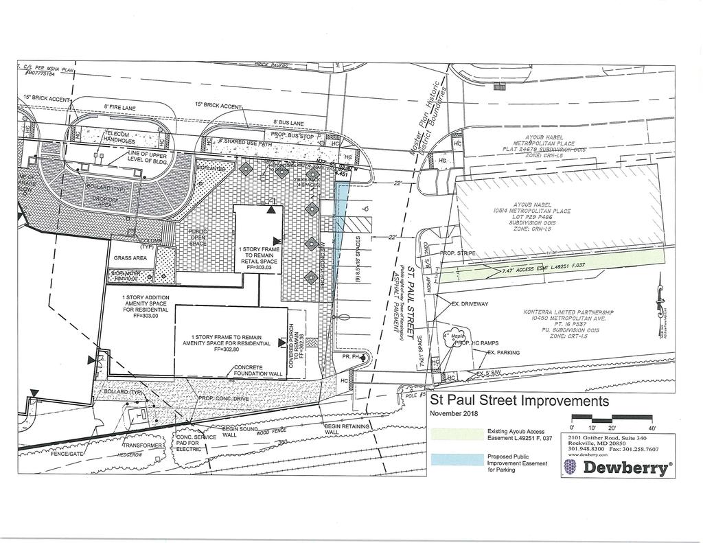
21 SECTION 4: COMMUNITY CORRESPONDENCE The Applicant has met all proper signage, noticing, and submission meeting requirements. The Applicant sent individual notice letters to neighboring residents, schools and businesses, on June 29, On May 3, 2018, the Applicant held the required pre-submission meeting at the Kensington Town Hall, which was attended by 36 citizens including the Mayor of Kensington. Town of Kensington The Mayor of the Town of Kensington (Town) transmitted four letters to Staff regarding the proposed Project (Attachment 4). Two letters, dated July 18, 2018 and October 15, 2018, indicate the Town s continued support of the Project. In a letter dated November 7, 2018, the Mayor states that the Town and the Applicant have agreed in principle on the concept for continued public use of St. Paul Street in conjunction with the proposed Project and the existing uses on the east side of the street. This agreement in principle recognizes that the Town will continue to have jurisdiction and control of St. Paul Street, including its public parking, and will continue to maintain and regulate this right-of-way. It also takes existing easements and agreements into account. The letter includes a sketch of the St. Paul Street Improvements. The fourth letter, dated November 13, 2018, addresses the bike share station recommendation discussed in the MCDOT letter. The letter explains the Town s opposition to the MCDOT recommendation for a bikeshare station on the Property given the demographic of the future residential occupants and because the proposed streetscape improvements along Metropolitan Avenue will be more beneficial to the future residents and the overall community. Staff concurs with the Applicant and the Town that a bikeshare station is not appropriate at this location given the demographic of the future residents of the building, the amount of bike parking provided in association with this Project, and the relatively small area that comprises the public open space. However, Staff recommends that the Applicant make a contribution towards the bikeshare program, to be reviewed and approved by MCDOT. Other Correspondence To date Staff received two pieces of correspondence from the community shown in Attachment 5whicih include: A letter of support from the Capital View Park Civic Association (CVPCA) Board stating that o The Applicant has listened to the community s wishes; o The Applicant is maintaining the historic character of the site and surrounding area; o The proposed design is in keeping with the unique and moderately scaled architecture along Metropolitan Avenue; and o The proposed development will improve pedestrian safety. A resident requested that the County conduct an independent traffic study to account for traffic from deliveries and services for the proposed facility. o Staff response: Under the Subdivision Staging Policy, a traffic study is not required for the Project because the number of weekday peak hour morning and evening person trips is fewer than the standard of 50 or more trips. In addition, Transportation Planning, MCDOT, and SHA Staff reviewed the proposal, and all agencies Page 21
22 have recommended approval. The County does not conduct independent traffic studies for proposed developments. Page 22
23 SECTION 5: PRELIMINARY PLAN ANALYSIS AND FINDINGS Under Section D, the Planning Board must make the following findings to approve a Preliminary Plan: 1. The layout of the subdivision, including size, width, shape, orientation and diversity of lots, and location and design of roads is appropriate for the subdivision given its location and the type of development or use contemplated and the applicable requirements of Chapter 59. The size, width, shape, and orientation of the proposed lot will be appropriate for the location. The Preliminary Plan will accommodate development on the Property at an appropriate and efficient location. The proposed lot was reviewed for compliance with the dimensional requirements for the CRT Zone as specified in the Zoning Ordinance. The proposed lot will meet all the dimensional requirements for open space, lot, density, height, placement, form, building type and public benefits in the zone and accommodate the proposed use as set out in Table 1 below. Table 1 Development Standards for the CRT-1.5, C-1.5, R-1.5, H-60 Section Optional Method of Development Required/Allowed Proposed Gross Tract Area n/a 1.93 ac. (84,129 sf) Dedication (Total) n/a 0.34 ac. (14,835 sf) Previous n/a 0.25 ac. (11,089 sf) Proposed n/a 0.09 ac. (3,746 sf) Net Lot Area n/a 1.59 ac. (69,294 sf) Open Space (min.) Public Open Space (min.) 5% (3,465 sf) 5.2% (3600 sf.) Density and Height (max.) Base Density 1.5 FAR (126, sf.) 1.5 FAR (126,193 sf) Commercial Density 1.5 FAR (126, sf.) 0.01 FAR (1,000 sf) Residential Density 1.5 FAR (126, sf.) 1.64 FAR (137,855 sf) 1 Independent Living Units n/a 63 units (74,762 sf) Base Density n/a 53 units (62,100 sf) Bonus Density 13,662 sf 1 10 units (12,662sf) 2 Residential Care Beds n/a 79 beds (63,093 sf) Total Density (including MPDU bonus density) n/a 1.65 FAR (138,855 sf) Height 60' 60' MPDUs (min.) Independent Living Units 12.5% (8 units) 15% (10 units/12,662 sf) Setbacks Street 3 ft Side Established at Site Plan 24 ft Rear 14 ft 1 A 22% bonus density is allowed for providing 15% of the independent living units as MPDUs under Section C.1.a. 2 A 20% density bonus is proposed Page 23
24 2. The Preliminary Plan substantially conforms to the Master Plan. As described below, the Preliminary Plan substantially conforms to the applicable recommendations/requirements of the 2012 Kensington Sector Plan. The Property is located within the 2012 Kensington Sector Plan. The Sector Plan s vision is To promote a mixed-use Town Center with pedestrian-friendly connections to the vibrant neighborhoods that define Kensington (page 1). The Sector Plan s broad goal is to reinvigorate the Town Center while preserving Kensington s scale and historic character (page 1). The Property is identified in the CS-1, CS-2 Konterra and Metropolitan Avenue South area, which is within the Crafts/Services District of the Sector Plan. The Crafts/Services District includes West Howard Antiques District and service industrial activities on the south side of Metropolitan Avenue. Within the Crafts/Services District the Sector Plan proposes to preserve the character of this district. Aesthetic and environmental improvements should enhance the area s look and function without compromising its eclectic nature. The portion of this district on the south side of Metropolitan Avenue is recommended for the CRT Zone, with total maximum FARs of 1.5. (page 34). The proposed development introduces residential uses with ancillary retail near the Kensington MARC Station, with pedestrian and streetscape improvements that help to both promote and reinvigorate the Town Center. The proposal has gone through multiple reviews with Planning Staff, HPC Staff, the Town of Kensington and the HPC, and as result, the proposed buildings and public spaces will provide significant aesthetic and environmental improvements that will enhance the area s look and function while echoing the materials and architectural vocabulary of the Historic District. Within the CS-1, CS-2 Konterra and Metropolitan Avenue South area, the Sector Plan recommends: Preserving existing retail and service industrial uses in this area The opportunity to introduce some residential uses while maintaining the existing nonresidential uses in place. A height of 60 feet to accommodate additional density in a mixed-use development with public benefits, such as quality design, streetscape, open space, or public parking, and create a mixed-use, pedestrian-centered realm on both sides of Metropolitan Avenue. The remainder of the area which includes the Subject Property is recommended for CRT 1.5: C 1.5, R 1.5, H 60. This Application, as conditioned, is consistent with the recommended zone and height requirements for the area as envisioned by the Sector Plan. The mixed-use Project provides residential possibilities with 15% MPDUs and up to 1,000 square feet of non-residential uses. The Project is also consistent with the recommendation of revitalization to this area, while Page 24
25 providing an appropriate mix of public benefits, high quality design that has been carefully considered in the context of the Historic District, enhanced streetscape and pedestrian realm along Metropolitan Avenue, thoughtfully designed public open space at and near the intersection of Metropolitan Avenue and St. Paul Street. 3. Public Facilities will be adequate to support and service the area of the subdivision Transportation Vehicular Access Vehicular access for the residential development s garage and drop-off/pick-up loop is from Metropolitan Avenue. The commercial space in the historic structures will be accessed from St. Paul Street. Sector/Master-Planned Roadways and Bikeways The master-planned transportation facilities are designated below in accordance with the 2012 Kensington Sector Plan and the 2018 Bicycle Master Plan. Metropolitan Avenue (MD-192) is designated as a Business District Street, B-4, with a recommended 70-foot right-of-way. The existing right-of-way varies between 40 and 56 feet along the Property frontage. To fulfill the required dedication, the Applicant must dedicate a total of 35 feet from Metropolitan Avenue s centerline. The 2018 Bicycle Master Plan does not recommend bicycle facilities along this segment of Metropolitan Avenue. According to the Town of Kensington, St. Paul Street is a public right-of-way that is under the jurisdiction and control of the Town, although there does not appear to be a definitive record of dedication for the road. The Town and the Applicant have come to a preliminary agreement that allows the Town to maintain jurisdiction and control of St. Paul Street, including the public parking, while also recognizing existing easements and agreements. A portion of the public parking along St. Paul Street is located on the Property, and the Applicant will grant a public improvement easement on this area. The Kensington Sector Plan recommends a new pedestrian/bicycle connection (LB-6) over the CSX rail right-of-way and The Bikeways Master Plan recommends an off-street trail crossing the CSX right-of-way between St. Paul Street and Howard Avenue. However, Staff finds that a CIP project would be a more appropriate mechanism to construct this connection given the cost and complexity required of such a project. Pedestrian Facilities Metropolitan Avenue currently has five (5)-foot-wide sidewalks, a two (2) to three (3)-foot-wide ornamental brick buffer, and a minimal green panel. The Applicant is proposing an eight (8)-footwide asphalt sidepath with a seven (7)-foot-wide green panel along the Metropolitan Avenue frontage. The Applicant is proposing a seven (7)-foot-wide sidewalk along St. Paul Street. Public Transit Service The site is adjacent to the Kensington MARC Station. In addition to MARC service, the nearest public transit routes are as follows: Page 25
26 Ride On Route 4 operates along Howard Avenue, Kent Street, and Stoneybrook Drive between the Kensington (I.e., Knowles Avenue & Amory Avenue) and Shady Grove Metrorail Stations with half-hour headways on weekdays only. Ride On Route 5 operates along Metropolitan Avenue between the Twinbrook Metrorail Station and the Shady Grove Metrorail Station with half-hour headways on weekdays and weekends. Ride On Route 33 operates along Howard Avenue and Kensington Parkway between the Glenmont Metrorail Station and the NIH/Medical Center Metrorail Station with half-hour headways on weekdays only. The nearest bus stops are located at the Metropolitan Avenue/St. Paul Street intersection, the Howard Avenue/Fawcett Street intersection, and the Kent Street/Stoneybrook Drive intersection. Connecticut Avenue (MD 185) is located approximately 1,300-feet to the west, where the following two bus routes operate: Ride On route 34 operates along Cedar Lane to Connecticut Avenue to University Boulevard between Aspen Hill (i.e., Grand Road & Bel Pre Road) and the Friendship Heights Metrorail Station with half-hour headways on weekdays and weekends. Metrobus route L8 operates along Connecticut Avenue between the Aspen Hill (i.e., Grand Road & Bel Pre Road) and the Friendship Heights Metrorail Station with half-hour headways on weekdays and weekends. Local Area Transportation Review (LATR) Per the 2016 Subdivision Staging Policy, if use and occupancy certificates for 75% of the originally approved development were issued more than 12 years before the LATR study scope request, the [traffic statement] study must be based on the increased number of peak-hour trips rather than the total number of peak-hour trips. Mizell Lumber & Hardware operated on the site since 1931, exceeding the 12-year threshold for use and occupancy. Therefore, the traffic statement was based only on the increased number of peak-hour trips by the senior housing rather than the total number of peak-hour trips that includes the reduced square footage of general retail space from 8,059 to 3,000. Under the Subdivision Staging Policy, a traffic study is not required because the number of weekday peak hour morning and evening person trips is fewer than the standard of 50 or more trips. In addition, the number of transit, pedestrian, and bike trips is fewer than the 50-trip standard. Therefore, the LATR test is satisfied and a traffic study is not required. School Capacity This Preliminary Plan is subject to the FY19 Annual School Test. However, the Annual School Test does not apply to this Property because the proposed use does not generate any children/students. Other Public Facilities and Services The Property is proposed to be served by public water and sewer. This Application has been reviewed by the Montgomery County Department of Permitting Services Fire Department Access and Water Supply Comments, which has determined that the Property will have appropriate access for fire and rescue vehicles. Other public facilities and services, such as police stations, firehouses and health services are currently operating within the standards set by the Subdivision Staging Policy resolution currently in effect and will be adequate to serve the Property. Electrical, telecommunications, and gas services are also available to serve the Property. Page 26
27 4. All Forest Conservation Law, Chapter 22A requirements are satisfied Environmental Guidelines Staff approved a Natural Resource Inventory/Forest Stand Delineation (NRI/FSD # ) on November 20, The site lies in the Lower Rock Creek watershed and contains no forest, streams, wetlands, or floodplains, or any associated buffers. Forest Conservation The Property is subject to the Montgomery County Forest Conservation Law (Chapter 22A of the County Code) and the Applicant has submitted a Forest Conservation Plan (Attachment 10) in conjunction with the Preliminary Plan and Site Plan. There is no forest onsite but a 0.30-acre afforestation requirement, which will be met by fee-in-lieu payment. Forest Conservation Variance Section 22A-12(b) (3) of the Forest Conservation Law provides criteria that identify certain individual trees as high priority for retention and protection. Any impact to these trees, including removal or disturbance within the tree s critical root zone (CRZ), requires a variance. An applicant for a variance must provide certain written information in support of the required findings in accordance with Section 22A-21 of the County Forest Conservation Law. The law requires a variance to impact trees that: measure 30 inches or greater diameter at breast height (DBH); are part of a historic site or designated with a historic structure; are designated as national, State, or County champion trees; are at least 75 percent of the diameter of the current State champion tree of that species; or trees, shrubs, or plants that are designated as Federal or State rare, threatened, or endangered species. The Applicant submitted a variance request to remove one tree and to impact, but not remove, one tree that are considered high priority for retention under Section 22A-12 (b) (3) of the County Forest Conservation Law. Unwarranted Hardship for Variance Tree Impacts Per Section 22A-21, a variance may only be granted if the Planning Board finds that leaving the requested trees in an undisturbed state will result in unwarranted hardship. The requested variance is necessary due to the need to demolish the existing house, construct a public road, and the infill nature of this development. The site is constrained by existing development on all sides, which limits flexibility in grading. Page 27
28 Table 4- Variance Trees ID Species Size Condition Impacts Removal #02 Silver maple 51 Fair Within the footprint of the proposed building. Impacts #03 Red maple 44 Good Impacts from sidewalk and roadway construction. Across Metropolitan Avenue. Variance Findings Based on the review of the variance request and the proposed Preliminary Forest Conservation Plan, Staff makes the following findings: 1) Granting the variance will not confer on the applicant a special privilege that would be denied to other applicants. Granting this variance will not confer a special privilege on the Applicant as disturbance of the specified trees is a result of the need to design the development around the existing historic buildings. The Applicant will also not be able to construct the underground parking without being able to disturb the existing trees. 2) The need for the variance is not based on conditions or circumstances which are the result of the actions by the applicant. The requested variance is not based on conditions or circumstances that are the result of actions by the Applicant. The variance is necessary due to the constraints of the existing historic buildings and the need to build underground parking. The impact to the trees is the minimum disturbance necessary to build the proposed senior living facility, with associated infrastructure. 3) The need for the variance is not based on a condition relating to land or building use, either permitted or non-conforming, on a neighboring property. The requested variance is a result of the location of trees and the proposed development and not a result of land or building use on a neighboring property. 4) Granting the variance will not violate State water quality standards or cause measurable degradation in water quality. The Applicant will plant four (4) three (3)-inch caliper native shade trees to replace the form and function of the variance tree proposed for removal. In addition, the site will be developed in accordance with the Maryland Department of the Environment criteria for stormwater management. Page 28
29 Mitigation for Trees Subject to the Variance Provisions The Applicant is requesting a variance to remove one tree. The one (1) tree (listed in the removal table above) will be mitigated at a rate of one (1)-inch caliper per four (4)-inches DBH removed, using a minimum three (3)-inch caliper native shade tree. The Applicant will plant four (4) three (3)-inch caliper trees which must be shown on the Final Forest Conservation Plan prior to Certified Site Plan. County Arborist s Recommendation of the Variance In accordance with Montgomery County Code Section 22A-21(c), the Planning Department is required to refer a copy of the variance request to the County Arborist in the Montgomery County Department of Environmental Protection. The County Arborist has not made any recommendations on the variance request as of the time of staff report posting. Variance Recommendation Staff recommends that the variance be granted. 5. All stormwater management, water quality plan, and floodplain requirements of Chapter 19 are satisfied. The Applicant received approval of their stormwater management concept from the Montgomery County Department of Permitting Services, Water Resources Section on October 29, The concept plan proposes to meet the required stormwater management goals via twelve (12) on-site micro-bioretention planters and two surface micro-bioretention facilities that are intended to treat the public right-of-way. A waiver is being requested because the entire required volume cannot be treated in on-site ESD or structural measures. 6. Any other applicable provision specific to the property and necessary for approval of the subdivision is satisfied. Noise The Property is impacted by two types of transportation noise types train and mixed automotive traffic (cars and trucks). The Property is located on the north side of the CSX Transportation railroad tracks, which are heavily used for both passenger and freight trains, and on the south side of Metropolitan Avenue. The Montgomery County Staff Guidelines for the Consideration of Transportation Noise Impacts in Land Use Planning and Development is used to review traffic noise impacts on residential developments. In this area of the County, the Guidelines recommend a maximum value of 65 dba Ldn for exterior recreation areas and 45 dba Ldn for indoor residential spaces. The Applicant submitted a noise study, analyzing existing noise impacts from current traffic and future traffic volumes. The Property is impacted by transportation noise and requires mitigation to meet interior and exterior noise levels (Figure 9). Page 29
 to fourteen (14) feet in height, to mitigate exterior noise in the outdoor")

30 Figure 9: Future Unmitigated ground level noise The Applicant has proposed an absorptive noise barrier, ranging from twelve (12) to fourteen (14) feet in height, to mitigate exterior noise in the outdoor recreation area. With this noise barrier, the exterior noise levels are reduced from 75 dba Ldn to below 65 dba Ldn in the outdoor recreation area (Figure 10). Figure 10: Future mitigated ground level noise Page 30
31 The proposed noise barrier does not mitigate the noise impacts from Metropolitan Avenue. Therefore, the entire north, east, and south elevations, as well as a majority of the upper level west and courtyard elevations will be exposed to future transportation noise levels above 65 dba Ldn. Upgraded windows (operating and fixed) and doors which meet specific STC rating requirements must be installed for most residential units, whereas a typical residential window/door can be used for a small portion of the residential units on the west and courtyard elevations. When using the minimum STC rated windows/doors specified for each unit, along with the planned exterior wall construction, interior noise levels in all residential units will be below 45 dba Ldn. Page 31
32 SECTION 6: SITE PLAN ANALYSIS AND FINDINGS Under Section E.2, the Planning Board must find that the proposed development: a. satisfies any previous approval that applies to the site; The proposed development satisfies the conditions of Sketch Plan No b. satisfies under Section B.5 the binding elements of any development plan or schematic development plan in effect on October 29, 2014; Not applicable; there was not an applicable development plan or schematic development plan in effect on October 29, c. satisfies under Section B.5 any green area requirement in effect on October 29, 2014 for a property where the zoning classification on October 29, 2014 was the result of a Local Map Amendment; The zoning classification on October 29, 2014 was not the result of a Local Map Amendment. d. satisfies applicable use standards, development standards, and general requirements under this Chapter; 1. Use Standards Independent Living for Seniors and Residential Care Facilities (Over 16 Persons) are allowed as limited uses in the CRT Zone, and Retail/Service Establishments (up to 50,000 square feet) are permitted uses in the Zone. Residential Care Facilities do not have any applicable limited use standards. Under Section C.2.a, the limited use standards for an Independent Living Facility for Seniors are as follows: i. The facility must meet all applicable Federal, State, and County licensure, certificate, and regulatory requirements. Other Federal, State, or County agencies will enforce this standard. ii. Resident staff necessary for the operation of the facility are allowed to live on-site. The Applicant has not proposed that resident staff live onsite. iii. Occupancy of a dwelling unit is restricted to the following: a) a senior adult, as defined in Section 1.4.2, Defined Terms; b) other members of the household of a senior adult, regardless of age; c) a resident care-giver, if needed to assist a senior resident; or d) a person authorized to occupy housing provided under any federal or state program that is specifically designed and operated to assist seniors as defined in that program. Page 32
33 e) If imposing age restrictions that would limit occupancy otherwise allowed by this Subsection, the facility must only impose age restrictions that satisfy at least one type of exemption for housing for older persons from the familial status requirements of the federal "Fair Housing Act," Title VIII of the Civil Rights Act of 1968, as amended, or the state Fair Housing Act, Subtitle 7 of Title 20 of the Annotated Code of Maryland, State Government Article, as amended. The occupancy will be restricted accordingly by the Applicant. 2. Development Standards Table 1 demonstrates that the proposed development satisfied the development standards of the zone. 3. Public Benefits An optional method project of the proposed size in the CRT Zone typically requires 50 public benefits points in three different benefit categories. However, because the Project is providing a minimum of 15% MPDUs, one less benefit category is required. As demonstrated in Table 5, the Project will provide 68 public benefit points in five (5) different categories. Table 5: Public Benefits Section # Benefit Categories Max Points Allowed Points Proposed B: Transit Proximity B1 Transit Proximity C: Connectivity and Mobility C.2 Minimum Parking D: Diversity of Uses and Activities Enhanced Accessibility for the D.4 Disabled 20 4 D.6 Moderately Priced Dwelling Units n/a E: Quality Building and Site Design E.6 Structured Parking G: Building Reuse G.1 Building Reuse Total 68 Transit Proximity The Property confronts the Kensington MARC Train station, a Level 3 transit facility, across St. Paul Street. The Zoning Ordinance indicates that five (5) points can be awarded for a Property that confronts a Level 3 Transit Facility. Page 33
34 Connectivity and Mobility Minimum Parking: The Applicant is requesting points for providing fewer than the maximum allowed number of parking spaces. Points for this incentive are granted on a sliding scale up to a maximum of ten (10) points for providing no more than the minimum number of required parking spaces on-site. The minimum required number of on-site spaces is 74, the maximum number of spaces allowed is 110, and the Applicant is proposing 78 parking spaces. The Applicant is requesting eight (8) points in this subcategory as allowed using the calculation below from the Commercial/Residential and Employment Zones Incentive Density Implementation Guidelines (CR Guidelines). [110 (maximum allowed spaces)-78(proposed spaces)] / [110 (maximum allowed spaces)-74(minimum spaces required) *10 Diversity of Uses and Activities Enhanced Accessibility for Seniors or the Disabled: The Applicant requests four (4) points for providing 1.4% (2 out of 135) units that will meet American National Standards Institute (ANSI) A117.1 Residential Type A standards or an equivalent County standard. Four (4) points are allowed using the calculation below from the CR Guidelines: (2 (ANSI units)/135 (total units) *300 Moderately Priced Dwelling Units: The Applicant is requesting 30 points for providing 15% of the independent living units (10 out of 63) as MPDUs. Twelve points are granted for every one (1) point of MDPUs greater than 12.5%. Quality Building and Site Design Structured Parking: The Applicant is requesting twenty (20) points for providing all 78 on-site parking spaces in a below-grade structured parking garage. The points are calculated per the following equation: 78 (Below-grade spaces)/ 78 (Total spaces) *20] Building Re-Use The Applicant requests one (1) point for the adaptive re-use of 808 square feet within the two historic structures located along St. Paul Street per the following formula in the CR Guidelines: [808 (retained gross floor area)/ 42,064 (incentive density gross floor area)] x General Requirements Division 6.1 Site Access A 36-foot-wide curb cut from Metropolitan Avenue provides access to a 26-foot-wide driveway that leads to the garage of the proposed senior living facility and to the loading/service bay on the northwest corner of the building. Pedestrians and bicyclists can use the proposed eight-foot sidepath along the Property s Metropolitan Avenue frontage to access the front door of the building, or the sidewalk along St. Paul Street to access the proposed retail space. Page 34
35 Division 6.2 Parking and Loading Table 6: Parking Requirements Minimum Spaces Required Vehicle Parking (Reduced Parking Area) Retail 1000 sf Independent Living (market) 53 units Independent Living (MPDU) 10 units Residential Care Facility 79 beds Maximum Spaces Allowed Spaces Provided Total Vehicle Spaces Bicycle Parking Independent Living 16 spaces (95% n/a long term) Retail 1 space (15% n/a long term) Total Bicycle Spaces 17 n/a 16 long-term 4 short-term Loading Spaces Over 50 dwelling units 1 n/a 1 Division 6.3 Open Space and Recreation A 1.93-acre property with two right-of-way frontages in the CRT Zone requires 5% Public Open Space. The Project will provide a minimum of 5% public open space (or 3,711 square feet) in a contiguous area location along the Property's frontages on Metropolitan Avenue and St. Paul Street, centered around the proposed coffee shop. The area includes space for pedestrian circulation, landscaping, seating, and shade. Pursuant to Sections A.3 and B.2, a portion of the public open space area will be devoted to outdoor café seating. Tables 7 and Table 8 demonstrate compliance with the Recreation Guidelines. Page 35


36 Table 7: Proposed Onsite Recreation Facilities Table 8: Recreation Demand, Supply and Adequacy Division 6.4 General Landscaping and Outdoor Lighting Landscaping and lighting, as well as other site amenities, will be provided to ensure that these facilities will be safe, adequate, and efficient for year round use and enjoyment by residents and visitors. The Project provides street trees and planting beds and appropriate outdoor lighting to illuminate streets and sidewalks. e. satisfies the applicable requirements of: i. Chapter 19, Erosion, Sediment Control, and Stormwater Management; and ii. Chapter 22A, Forest Conservation. As described in the Preliminary Plan findings, the Application satisfies the applicable requirements of Chapter 19 and Chapter 22A. f. provides safe, well-integrated parking, circulation patterns, building massing and, where required, open spaces and site amenities; Parking, circulation, building massing, opens spaces, and site amenities will be safe and wellintegrated into the proposed development. Parking and Circulation Access to the Property will be from Metropolitan Avenue or St. Paul Street and on-site circulation is limited to vehicles accessing the loading dock or the garage from Metropolitan Avenue. The majority Page 36
37 of parking will be located in a below-grade structure that is completely integrated with the residential building. A limited number of parking spaces will be available along St. Paul Street to accommodate the proposed retail space. Short-term bicycle parking is proposed near the retail space and long-term bicycle parking is proposed in the underground parking garage. Building Massing The proposed building has been pulled up to Metropolitan Avenu, with community uses on the ground level to activate and enliven the streescape, while enhancing the pedestrain environment. The street facing building façades contain recesses and projections that help break down the scale of the building through both vertical and horizontal breaks providing visual interest along Metropolian Avenue and St. Paul Street. Open Spaces and Site Amenities The Project s public plaza creates a gathering place in a highly visible central location at the corner of Metropolitan Avenue and St. Paul Street, in close proximity to the Kensington MARC station. The plaza will include seating, landscaping, and signage associated with the historic buildings. Private amenities for the residents of the senior living facility include an interior courtyard and rooms inside the building for exercise and community activities. g. substantially conforms with the recommendations of the applicable master plan and any guidelines approved by the Planning Board that implement the applicable plan; As discussed in the Preliminary Plan section of the report, the proposed Project substantially conforms with the recommendations of the Kensington Sector Plan and the associated design guidelines. h. will be served by adequate public services and facilities including schools, police and fire protection, water, sanitary sewer, public roads, storm drainage, and other public facilities. If an approved adequate public facilities test is currently valid and the impact of the development is equal to or less than what was approved, a new adequate public facilities test is not required. If an adequate public facilities test is required the Planning Board must find that the proposed development will be served by adequate public services and facilities, including schools, police and fire protection, water, sanitary sewer, public roads, and storm drainage; As described in the Preliminary Plan section of this report, the Project will be served by adequate public services and facilities. i. on a property in a Rural Residential or Residential zone, is compatible with the character of the residential neighborhood; and Not applicable; the Property in not in a Rural Residential or Residential Zone. j. on a property in all other zones, is compatible with existing and approved or pending adjacent development. The Property is compatible with existing adjacent development. The Project adheres to the height and density of the Property's zone and with the recommendations contained in the Sector Plan. The Project will contribute to the diversity of housing opportunities and uses in Kensington's commercial Page 37
38 core, and will encourage a pedestrian-friendly Town Center, as envisioned in the Sector Plan. The building's architecture and design provides an appropriate scale that complements the existing and permitted density/heights of the surrounding properties. Additionally, through adaptive reuse, the Applicant intends to maintain and revitalize the historic resources on the Property, thereby contributing to the preservation of the unique and historic character of Kensington. SECTION 7: CONCLUSION The Applications meet all requirements established in the Subdivision Regulations and the Zoning Ordinance. Access and public facilities will be adequate to serve the proposed lot, the use conforms with the Master Plan and the general requirements of Chapter 59, and the Applications have been reviewed by other applicable county agencies, all of whom have recommended approval of the applications (Attachments 6, 7, 8, 9 Agency letters). Staff recommends approval of Preliminary Plan No and Site Plan No , with the conditions listed at the beginning of the Staff Report. Page 38
39 ATTACHMENT 1
40 ATTACHMENT 2


41 ATTACHMENT 3
42 ATTACHMENT 4
43 Mayor Tracey Furman Council Member Darin Bartram Council Member Bridget Hill-Zayat Council Member Conor Crimmins Council Member Duane Rollins October 15, 2018 Mr. Casey Anderson, Chair Montgomery County Planning Board 8787 Georgia Avenue Silver Spring MD Re: Solera Reserve Kensington Metropolitan Avenue Dear Mr. Anderson: The Development Team for the proposed Solera Reserve Kensington project presented the revised design plans to the Town at our October 8, 2018 Council Meeting. The Council and I were very pleased with the revised plans and the continued effort by Solera to incorporate feedback from various groups throughout the community. We also want to acknowledge the collaborative work between the Historic Preservation Commission and McCaffery Interests in restoring the two historic structures and the design connecting the old with the new. In addition, the entire group representing the Solera project has been a pleasure to work with during this process and we commend them for their ability to find solutions to our concerns. As we have expressed to you and the Planning Commission previously, the Solera Reserve Kensington project is well fitted for our community with respect to the 2012 Kensington and Vicinity Sector Plan, and we are looking forward to seeing this project take shape in early Sincerely, Tracey Furman Mayor Cc: Kensington Town Council Juan Cameron, McCaffery Intersts Emily Tettelbaum, Montgomery County Planning Town of Kensington 3710 Mitchell Street Kensington, MD Phone Fax
44
45
46 Mayor Tracey Furman Council Member Darin Bartram Council Member Bridget Hill-Zayat Council Member Conor Crimmins Council Member Duane Rollins November 13, 2018 Ms. Emily Tettlebaum, Senior Planner 8787 Georgia Avenue Silver Spring, Maryland Re: Solera Reserve Kensington Metropolitan Avenue Dear Ms. Tettlebaum: The Applicant for the Solera Reserve Kensington project, Metropolitan Avenue, contacted the Town with regards to MCDOT requiring a Bikeshare Station on the site of the proposed development project. In discussing the requirement with the Town Council at our November 5 th Council Meeting, we determined that this is not an appropriate requirement of the Applicant, as the use of the facility will house seniors, many of whom are physically challenged or will be receiving memory care. In addition, the Applicant has indicated to the Town that they intend to install bicycle storage spacess on site (16 long-term spaces and 1 short-term space) for senior residents or visitors to the property, which we feel is sufficient for their needs. Moreover, the Applicant has Metropolitan Avenue in order to enhance the walkability to and from their facility. We believe these improvements toward pedestrian safety and walkability at this location will provide a greater benefit to the residents of Solera Reserve Kensingtonn and the Kensington community. While we are appreciative that MCDOT is proactively looking for travel solutions within our community, we do not believe that the requirement for a BikeShare Station at Solera Reserve Kensington is appropriate considering the intended use. discussed with us their desire to improve pedestrian safety along Town of Kensington 3710 Mitchell Street Kensington, MD Phone Fax
47 Sincerely, Tracey Furman Mayor Cc: Rhoda Hersso-Ringsk, Montgomery Planning Kensington Town Council Juan Cameron, McCaffery Interests, Inc William Kominers, Lerch, Early & Brewer Town of Kensington 3710 Mitchell Street Kensington, MD Phone Fax
48 ATTACHMENT 5


49
50 ATTACHMENT 6
51

52 ATTACHMENT 7
53
54 ATTACHMENT 8
55 ATTACHMENT 9
56
57 ATTACHMENT 10
58 Dewberry ATTACHMENT 11 Dewberry Consultants LLC 2101 Gaither Road, Suite 340 Rockville, MD fax October 11, 2018 Mr. Mark Pfefferlie M-NCPPC 8787 Georgia Avenue Silver Spring, MD Re: Solera I Reserve Kensington PP# and SP# Variance Request for Tree Removal Dear Mr. Pfefferlie: As required by the State Forest Conservation Act, the Applicant, SM Kensington Senior Living RE, LLC, hereby requests a variance for the removal of one (1) specimen tree (30" diameter of greater) on the property located at St. Paul Street and Metropolitan Avenue, in the Town of Kensington, Maryland (the "Property") in connection with the Solera I Reserve Kensington Project, and impacts to the critical root zone of (1) specimen tree (30" diameter of greater) on the property located across Metropolitan Avenue from the site. The Applicant, SM Kensington Senior Living RE, LLC, proposes to redevelop the Property under the Optional Method of Development with a senior living facility, and to adaptively re-use the existing historic buildings for retail/service use and/or residential amenities. The Property is located in the commercial center of Kensington, in the southwest quadrant of the intersection of Metropolitan Avenue and St. Paul Street. The CSX Railroad tracks run along the Property's southern boundary and the Property is located within 300 feet of the MARC Train Station serving the Town of Kensington. The Property has a total tract area (gross) of approximately 84,129 square feet (or 1.93 acres), which includes land previously dedicated, and proposed to be dedicated, for right-of-way. Subsequent to Preliminary Plan approval and related dedications, the Property will have a lot area (net) of 68,997 square feet (or 1.59 acres). The Property is improved with several single-story buildings and associated surface parking. The two buildings on the east side of the Property, along St. Paul Street, are located within the Kensington Historic District and listed as historic structures. The site, including the historic buildings, were used until recently for the Mizell Lumber & Hardware Company and Bergman's Dry Cleaners. The existing buildings on the Property will be demolished ( with the exception of the historic portions of the designated historic buildings) to accommodate the redevelopment of the Property with a five-story senior living facility, including up to 135 units (or up to 142 beds). The Applicant is planning to adapt and re-use the historic buildings (to the extent structurally feasible) for residential amenities and/or up to 3,000 square feet of street-activating retail/service use (the "Project").
59
60
61
62
63 ATTACHMENT 12 HISTORIC PRESERVATION COMMISSION Marc Elrich County Executive William Kirwan Chairman December 7, 2018 Mr. Casey Anderson Chair, Montgomery County Planning Board 8787 Georgia Avenue Silver Spring, MD RE: Solera Kensington, Preliminary Plan No and Site Plan No Dear Mr. Anderson and Members of the Planning Board: The Historic Preservation Commission (HPC) reviewed the proposed Solera Kensington Preliminary and Site Plan project at three (3) HPC Preliminary Consultations this year on September 5 th, October 10 th, and October 24 th. As you know this project is located partially within the boundaries of the Kensington Master Plan Historic District and includes two historic buildings dating from the earlytwentieth century on St. Paul Street. At our hearings the HPC gave the applicants direction and suggestions regarding the size, mass, scale, height and overall architectural and historical compatibility of the new proposed Senior Living Center and the proposed rehabilitation of the historic commercial buildings. The HPC is supportive of this project. The applicants were responsive to Commission feedback at each meeting and worked through multiple iterations of their design. Our comments focused on the scale, massing, and materiality of the southeast façade of the proposed building confronting the historic resources, the one-story connecting link to the historic resources, and avoiding any detrimental impact the link may have upon existing character defining features of the historic resources. The proposal is much improved at this point in the process and we expect further refinements to the design when we see them back before the HPC. The applicants understand that a final Historic Area Work Permit (HAWP) is required before they can proceed to permitting and construction. Historic Preservation Commission 8787 Georgia Avenue Silver Spring, Maryland / / FAX


64 HISTORIC PRESERVATION COMMISSION Marc Elrich County Executive William Kirwan Chairman A major construction project such as this has the potential to be disruptive to the character of a historic district. We are pleased to see that this proposal will not only preserve and protect the historic buildings, but will create new and vibrant spaces within Kensington for the enjoyment of current and future residents. The HPC supports this proposal and recommends that the Planning Board approve the project. Very Sincerely, cc. HPC Members Town of Kensington William Kirwan Chair, Historic Preservation Commission Historic Preservation Commission 8787 Georgia Avenue Silver Spring, Maryland / / FAX
MONTGOMERY COUNTY PLANNING DEPARTMENT THE MARYLAND-NATIONAL CAPITAL PARK AND PLANNING COMMISSION
 MONTGOMERY COUNTY PLANNING DEPARTMENT THE MARYLAND-NATIONAL CAPITAL PARK AND PLANNING COMMISSION MCPB Item No. Date: 12-10-15 Leisure World Clubhouse II Addition Fitness Center, Limited Site Plan Amendment
MONTGOMERY COUNTY PLANNING DEPARTMENT
 MONTGOMERY COUNTY PLANNING DEPARTMENT THE MARYLAND-NATIONAL CAPITAL PARK AND PLANNING COMMISSION MCPB Item No.: Date: 5-03-18 Pike and Rose, Phase I: Site Plan Amendment No. 82012002D Rhoda Hersson-Ringskog,
MONTGOMERY COUNTY PLANNING DEPARTMENT THE MARYLAND-NATIONAL CAPITAL PARK AND PLANNING COMMISSION
 MONTGOMERY COUNTY PLANNING DEPARTMENT THE MARYLAND-NATIONAL CAPITAL PARK AND PLANNING COMMISSION MCPB Item No. Date: 04/05/2018 Solera Reserve at Kensington, Sketch Plan No. 320180080 Description Garry
MONTGOMERY COUNTY PLANNING DEPARTMENT THE MARYLAND-NATIONAL CAPITAL PARK AND PLANNING COMMISSION
 MONTGOMERY COUNTY PLANNING DEPARTMENT THE MARYLAND-NATIONAL CAPITAL PARK AND PLANNING COMMISSION MCPB Item No. Date: 3.10.2016 Site Plan 820160040 Nora School Parker Smith, Planning Technician, Area 1,
MONTGOMERY COUNTY PLANNING DEPARTMENT Newell Street. Site Plan Item #2. Maryland-National Capital Park and Planning Commission
 8001 Newell Street Site Plan 820140020 Item #2 December 19, 2013 Redlined Conditions 1. The Applicant must comply with the conditions of approval for Project Plan 920130020 in MCPB Resolution No. 13-74.
MONTGOMERY COUNTY PLANNING DEPARTMENT THE MARYLAND-NATIONAL CAPITAL PARK AND PLANNING COMMISSION
 MONTGOMERY COUNTY PLANNING DEPARTMENT THE MARYLAND-NATIONAL CAPITAL PARK AND PLANNING COMMISSION MCPB Item No. Date: 1/26/12 Hanover Shady Grove, Sketch Plan 320120020 Joshua Sloan, Coordinator, Joshua.Sloan@MontgomeryPlanning.org,
MONTGOMERY COUNTY PLANNING DEPARTMENT THE MARYLAND-NATIONAL CAPITAL PARK AND PLANNING COMMISSION
 MONTGOMERY COUNTY PLANNING DEPARTMENT THE MARYLAND-NATIONAL CAPITAL PARK AND PLANNING COMMISSION The Goddard School in North Bethesda Preliminary Plan Amendment 11996015B and Site Plan Amendment 82006005A
MONTGOMERY COUNTY PLANNING DEPARTMENT THE MARYLAND-NATIONAL CAPITAL PARK AND PLANNING COMMISSION
 MONTGOMERY COUNTY PLANNING DEPARTMENT THE MARYLAND-NATIONAL CAPITAL PARK AND PLANNING COMMISSION MCPB Item No. Date: 06-12-14 King of the Nations Christian Fellowship Church: Limited Site Plan Amendment
Clarksburg Square Road Extension
 Clarksburg Square Road Extension Preliminary Plan No. 120140060 Site Plan No. 820140050 Site Plan Amendment No. 82007022C (Clarksburg Town Center) Clarksburg SPA Water Quality Plan Mandatory Referral MR2015008
I. Introduction. Prior Approvals
 Statement of Justification First National Bank 19790 Crystal Rock Drive, Germantown, Maryland Application for Site Plan and Limited Preliminary Plan Amendment I. Introduction DPH Architecture, for First
MONTGOMERY COUNTY PLANNING DEPARTMENT
 MONTGOMERY COUNTY PLANNING DEPARTMENT THE MARYLAND-NATIONAL CAPITAL PARK AND PLANNING COMMISSION Ashburton Elementary School Addition, Mandatory Referral, MR2018009 MCPB Item No. Date: 02-15-18 Troy Leftwich,
MONTGOMERY COUNTY PLANNING DEPARTMENT THE MARYLAND-NATIONAL CAPITAL PARK AND PLANNING COMMISSION
 MONTGOMERY COUNTY PLANNING DEPARTMENT THE MARYLAND-NATIONAL CAPITAL PARK AND PLANNING COMMISSION Montgomery Auto Sales Park: Preliminary Plan No. 11985027A, Site Plan No. 820140130 and Site Plan No. 820140140
MONTGOMERY COUNTY PLANNING DEPARTMENT THE MARYLAND-NATIONAL CAPITAL PARK AND PLANNING COMMISSION
 MONTGOMERY COUNTY PLANNING DEPARTMENT THE MARYLAND-NATIONAL CAPITAL PARK AND PLANNING COMMISSION MCPB Item No.: 2 Date: 12-19-13 Site Plan 820140020, 8001 Newell Street Neil Braunstein, AICP, Area 1, neil.braunstein@montgomeryplanning.org,
MONTGOMERY COUNTY PLANNING DEPARTMENT THE MARYLAND NATIONAL CAPITAL PARK AND PLANNING COMMISSION
 MONTGOMERY COUNTY PLANNING DEPARTMENT THE MARYLAND NATIONAL CAPITAL PARK AND PLANNING COMMISSION MCPB Item No. 3 Date: 1.5.17 7272 Wisconsin Avenue: Sketch Plan Amendment No. 32016004A, Preliminary Plan
MONTGOMERY COUNTY PLANNING DEPARTMENT THE MARYLAND-NATIONAL CAPITAL PARK AND PLANNING COMMISSION MCPB Item No.: 13 Date: 07/19/18
 MONTGOMERY COUNTY PLANNING DEPARTMENT THE MARYLAND-NATIONAL CAPITAL PARK AND PLANNING COMMISSION MCPB Item No.: 13 Date: 07/19/18 Black Hill / ViaSat: Project Plan No. 92012004B, Preliminary Plan No. 12012021B,
MONTGOMERY COUNTY PLANNING DEPARTMENT THE MARYLAND-NATIONAL CAPITAL PARK AND PLANNING COMMISSION
 MONTGOMERY COUNTY PLANNING DEPARTMENT THE MARYLAND-NATIONAL CAPITAL PARK AND PLANNING COMMISSION MCPB Item No. Date: 10.25.18 Artery Plaza: Site Plan Amendment 81984002E SD Stephanie Dickel, Planner Coordinator,
MONTGOMERY COUNTY PLANNING DEPARTMENT
 MONTGOMERY COUNTY PLANNING DEPARTMENT THE MARYLAND-NATIONAL CAPITAL PARK AND PLANNING COMMISSION MCPB Item No. 4 Date: 12-15-16 CVS Derwood: Site Plan No. 820160150 Calvin Nelson, Jr., Planner Coordinator,
MONTGOMERY COUNTY PLANNING DEPARTMENT THE MARYLAND-NATIONAL CAPITAL PARK AND PLANNING COMMISSION
 MONTGOMERY COUNTY PLANNING DEPARTMENT THE MARYLAND-NATIONAL CAPITAL PARK AND PLANNING COMMISSION MCPB Item No. 3 4/3/14 4990 Fairmont Avenue, Site Plan 820140060 Erin Banks, AICP, Senior Planner, Area
The subject site plan amendment proposes the following revisions to the approved site plan:
 PROPOSED AMENDMENT The subject site plan amendment proposes the following revisions to the approved site plan: 1. The building footprint was modified to accommodate the revised architectural design. 2.
MONTGOMERY COUNTY PLANNING DEPARTMENT THE MARYLAND-NATIONAL CAPITAL PARK AND PLANNING COMMISSION
 MONTGOMERY COUNTY PLANNING DEPARTMENT THE MARYLAND-NATIONAL CAPITAL PARK AND PLANNING COMMISSION MCPB Item No. 8 Date: 12-15-16 Montgomery Village Center Sketch Plan No. 320170020 TL Troy Leftwich, Senior
MONTGOMERY COUNTY PLANNING DEPARTMENT THE MARYLAND-NATIONAL CAPITAL PARK AND PLANNING COMMISSION
 MONTGOMERY COUNTY PLANNING DEPARTMENT THE MARYLAND-NATIONAL CAPITAL PARK AND PLANNING COMMISSION MCPB Item No. Date: 9/22/16 Ripley II: Sketch Plan Amendment No. 32015003A, Preliminary Plan No. 120160190,
Westwood Shopping Center Sketch Plan, Plan # February 23, 2017 Item # 9
 Westwood Shopping Center Sketch Plan, Plan # 320170010 February 23, 2017 Item # 9 Westwood II Site 64,111 s.f. Manor Care site: vacant two story building HOC-Westwood Towers, 15 story tower To be considered
MONTGOMERY COUNTY PLANNING DEPARTMENT
 MONTGOMERY COUNTY PLANNING DEPARTMENT THE MARYLAND-NATIONAL CAPITAL PARK AND PLANNING COMMISSION Ourisman Ford at Montgomery Mall, Sketch Plan No. 320170100 MCPB Item No. Date: 11-30-17 LS Lori Shirley,
MONTGOMERY COUNTY PLANNING DEPARTMENT
 MONTGOMERY COUNTY PLANNING DEPARTMENT THE MARYLAND-NATIONAL CAPITAL PARK AND PLANNING COMMISSION MCPB Consent Date: 4-26-18 Cabin John Auto Park (N. Bethesda Home Depot), Site Plan Amendment No. 81980017A
MONTGOMERY COUNTY PLANNING DEPARTMENT
 MONTGOMERY COUNTY PLANNING DEPARTMENT THE MARYLAND-NATIONAL CAPITAL PARK AND PLANNING COMMISSION MCPB Item # Date: 9-6-18 Ourisman Ford at Montgomery Mall, Site Plan No. 82009014B Emily Tettelbaum, Planner
MONTGOMERY COUNTY PLANNING DEPARTMENT THE MARYLAND-NATIONAL CAPITAL PARK AND PLANNING COMMISSION
 MONTGOMERY COUNTY PLANNING DEPARTMENT THE MARYLAND-NATIONAL CAPITAL PARK AND PLANNING COMMISSION Ashton Market: Preliminary Plan No. 120180180 and Site Plan No. 820180160 Jonathan Casey, Senior Planner,
MONTGOMERY COUNTY PLANNING DEPARTMENT THE MARYLAND-NATIONAL CAPITAL PARK AND PLANNING COMMISSION
 MONTGOMERY COUNTY PLANNING DEPARTMENT THE MARYLAND-NATIONAL CAPITAL PARK AND PLANNING COMMISSION MCPB Item No. Date: 05/12/2016 North Bethesda Conference Center Parking Structure, Mandatory Referral No.
MONTGOMERY COUNTY PLANNING DEPARTMENT
 MONTGOMERY COUNTY PLANNING DEPARTMENT THE MARYLAND-NATIONAL CAPITAL PARK AND PLANNING COMMISSION MCPB Item No. Date: 12/20/2018 Nucci Subdivision, Preliminary Plan No. 120160170 MF Marco Fuster, Planner
MONTGOMERY COUNTY PLANNING DEPARTMENT THE MARYLAND-NATIONAL CAPITAL PARK AND PLANNING COMMISSION
 MONTGOMERY COUNTY PLANNING DEPARTMENT THE MARYLAND-NATIONAL CAPITAL PARK AND PLANNING COMMISSION MCPB Item No. Date10/25/12 Sketch Plan No. 32012004, White Flint Mall Redevelopment Nkosi Yearwood, Senior
MONTGOMERY COUNTY PLANNING DEPARTMENT
 MONTGOMERY COUNTY PLANNING DEPARTMENT THE MARYLAND-NATIONAL CAPITAL PARK AND PLANNING COMMISSION MCPB Item No.: 11 Date: 7-20-17 Burtonsville McDonalds: Site Plan No. 820150020 Jonathan Casey, Senior Planner,
MONTGOMERY COUNTY PLANNING DEPARTMENT THE MARYLAND-NATIONAL CAPITAL PARK AND PLANNING COMMISSION
 MONTGOMERY COUNTY PLANNING DEPARTMENT THE MARYLAND-NATIONAL CAPITAL PARK AND PLANNING COMMISSION 8015 Old Georgetown Road, Preliminary Plan 120160220, Site Plan 820160090 MCPB Item No.: 8 Date: 11-03-16
MONTGOMERY COUNTY PLANNING DEPARTMENT THE MARYLAND NATIONAL CAPITAL PARK AND PLANNING COMMISSION
 MONTGOMERY COUNTY PLANNING DEPARTMENT THE MARYLAND NATIONAL CAPITAL PARK AND PLANNING COMMISSION MCPB Item No. 7 Date: 7.19.18 ZOM Bethesda, Preliminary Plan No. 120180140 and Site Plan No. 820180120 Matthew
Harmony Technology Park Third Filing, Second Replat Custom Blending, Project Development Plan/Final Development Plan - FDP #130021
 ITEM NO FDP #130021 MEETING DATE July 23, 2013 STAFF Pete Wray ADMINISTRATIVE TYPE I HEARING STAFF REPORT PROJECT: APPLICANT: OWNER: Harmony Technology Park Third Filing, Second Replat Custom Blending,
Ripley East. Sketch Plan Amendment No A Preliminary Plan No Site Plan No MONTGOMERY COUNTY PLANNING DEPARTMENT
 Ripley East Sketch Plan Amendment No. 32015001A Preliminary Plan No. 120150220 Site Plan No. 820150130 Planning Board Hearing Date: December 3, 2015 Site Vicinity and Site Description Silver Spring Transit
MONTGOMERY COUNTY PLANNING DEPARTMENT
 MONTGOMERY COUNTY PLANNING DEPARTMENT THE MARYLAND-NATIONAL CAPITAL PARK AND PLANNING COMMISSION MCPB Item No. Date: 04/05/2018 850 Sligo Avenue Sketch Plan No. 320180090 Neil Sullivan, Planner Coordinator,
MONTGOMERY COUNTY PLANNING DEPARTMENT THE MARYLAND-NATIONAL CAPITAL PARK AND PLANNING COMMISSION
 MONTGOMERY COUNTY PLANNING DEPARTMENT THE MARYLAND-NATIONAL CAPITAL PARK AND PLANNING COMMISSION MCPB Item No. Date: 05-22-14 Consent Item - Park Potomac: Site Plan Amendment No. 82004015K MCS. Molline
MONTGOMERY COUNTY PLANNING DEPARTMENT THE MARYLAND-NATIONAL CAPITAL PARK AND PLANNING COMMISSION
 MONTGOMERY COUNTY PLANNING DEPARTMENT THE MARYLAND-NATIONAL CAPITAL PARK AND PLANNING COMMISSION Staff Report: Sketch Plan #320110010, Mid-Pike Plaza ITEM #: MCPB HEARING DATE: January 20, 2011 REPORT
DRAFT Northeast Quadrant of Kipling Avenue and Highway 7 DRAFT AUGUST 29, Goals Land Use. The goals of this Plan are to:
 AUGUST 29, 2017 12.15 Northeast Quadrant of Kipling Avenue and Highway 7 12.15.1 Goals 12.15.2 Land Use The goals of this Plan are to: 12.15.2.1 General Provisions: a) Ensure the development of a compact
MIDTOWN MIXED-USE VILLAGE. TECHNICAL DATA SHEET COMPONENT C-1 FOR PUBLIC HEARING - PETITION NUMBER Project No RZ1.1. Issued.
 N MIDTOWN MIXED-USE VILLAGE TECHNICAL DATA SHEET COMPONENT C- FOR PUBLIC HEARING - PETITION NUMBER 04-00 Project No. 496 Issued Revised SCALE: " = 0' N 0 0 0 40 RZ. c GENERAL PROVISIONS: a. SITE LOCATION.
MONTGOMERY COUNTY PLANNING DEPARTMENT THE MARYLAND-NATIONAL CAPITAL PARK AND PLANNING COMMISSION
 MONTGOMERY COUNTY PLANNING DEPARTMENT THE MARYLAND-NATIONAL CAPITAL PARK AND PLANNING COMMISSION Gables White Flint, Preliminary Plan No. 120150010 and Site Plan No. 820150010 MCPB Item No. Date: 4/30/2015
12 January 12, 2011 Public Hearing APPLICANT: TAILWIND DEVELOPMENT GROUP,LLC PROPERTY OWNER: CITY OF VIRGINIA BEACH
 12 January 12, 2011 Public Hearing APPLICANT: TAILWIND DEVELOPMENT GROUP,LLC PROPERTY OWNER: CITY OF VIRGINIA BEACH STAFF PLANNER: Faith Christie REQUEST: Conditional Change of Zoning (from PD-H1 Planned
Request Alternative Compliance to the prescribed criteria of the Oceanfront Resort District Form- Based Code. Staff Recommendation Approval
 Applicant Property Owner Steven H. Murden Public Hearing June 14, 2017 City Council Election District Beach Agenda Item 8 Request Alternative Compliance to the prescribed criteria of the Oceanfront Resort
MONTGOMERY COUNTY PLANNING DEPARTMENT THE MARYLAND-NATIONAL CAPITAL PARK AND PLANNING COMMISSION
 MONTGOMERY COUNTY PLANNING DEPARTMENT THE MARYLAND-NATIONAL CAPITAL PARK AND PLANNING COMMISSION MCPB Item No. 4 7/18/13 4990 Fairmont Avenue, Project Plan 920130070 & Preliminary Plan 120130230 Erin Grayson,
Gold Line Bus Rapid Transit Transit Oriented Development (BRTOD) Helmo Station Area Plan
 Helmo Station Area Plan") Appendix F Gold Line Bus Rapid Transit Transit Oriented Development (BRTOD) Helmo Station Area Plan Introduction and Purpose of the Plan The Gold Line Bus Rapid Transit facility is an eleven-mile dedicated
Appendix F Gold Line Bus Rapid Transit Transit Oriented Development (BRTOD) Helmo Station Area Plan Introduction and Purpose of the Plan The Gold Line Bus Rapid Transit facility is an eleven-mile dedicated
MONTGOMERY COUNTY PLANNING DEPARTMENT THE MARYLAND NATIONAL CAPITAL PARK AND PLANNING COMMISSION
 MONTGOMERY COUNTY PLANNING DEPARTMENT THE MARYLAND NATIONAL CAPITAL PARK AND PLANNING COMMISSION MCPB Item No. Date: 5.3.18 8000 Wisconsin Avenue Sketch Plan No. 320180120 Matthew Folden, Planner Coordinator,
MONTGOMERY COUNTY PLANNING DEPARTMENT
 MONTGOMERY COUNTY PLANNING DEPARTMENT THE MARYLAND-NATIONAL CAPITAL PARK AND PLANNING COMMISSION MCPB Item No. 5 Date: 11.29.2018 The Crescent at Chevy Chase, Preliminary Plan No. 120180150 and Site Plan
MONTGOMERY COUNTY PLANNING DEPARTMENT THE MARYLAND-NATIONAL CAPITAL PARK AND PLANNING COMMISSION
 MONTGOMERY COUNTY PLANNING DEPARTMENT THE MARYLAND-NATIONAL CAPITAL PARK AND PLANNING COMMISSION MCPB Item No. 6 Date: 5-9-13 Site Plan No. 820130090, West Chevy Chase Heights Erin Grayson, Senior Planner,
MONTGOMERY COUNTY PLANNING DEPARTMENT
 MONTGOMERY COUNTY PLANNING DEPARTMENT THE MARYLAND-NATIONAL CAPITAL PARK AND PLANNING COMMISSION 6000 Executive Boulevard, Sketch Plan No. 320180140 MCPB Item No. Date: 06/21/2018 Emily Tettelbaum, Senior
MONTGOMERY COUNTY PLANNING DEPARTMENT THE MARYLAND-NATIONAL CAPITAL PARK AND PLANNING COMMISSION
 MONTGOMERY COUNTY PLANNING DEPARTMENT THE MARYLAND-NATIONAL CAPITAL PARK AND PLANNING COMMISSION MCPB Item No. Date: 1/15/2015 Bethesda North Marriott Hotel and Conference Center: Limited Site Plan Amendment
PLANNING REPORT CITY OF EAGAN. APPLICANT: Cedar Grove Hospitality, LLC HEARING DATE: December 18, 2014
 PLANNING REPORT CITY OF EAGAN REPORT DATE: December 8, 2014 CASE: 19-PA-11-11-14 APPLICANT: Cedar Grove Hospitality, LLC HEARING DATE: PROPERTY OWNER: The Flats at Cedar APPLICATION DATE: Nov. 21, 2014
MONTGOMERY COUNTY PLANNING DEPARTMENT THE MARYLAND-NATIONAL CAPITAL PARK AND PLANNING COMMISSION
 MONTGOMERY COUNTY PLANNING DEPARTMENT THE MARYLAND-NATIONAL CAPITAL PARK AND PLANNING COMMISSION MCPB Item No.: 9 Date: 07-20-17 Topgolf - Germantown: Preliminary Plan Amendment No. 12007065B and Site
DRAFT. October Wheaton. Design Guidelines
 October 2011 DRAFT Wheaton Design Guidelines 2 Draft - Design Guidelines - Wheaton Sector Plan Contents 04 Section 1: Introduction 06 Section 2: Context 08 Section 3: Design Guidelines 09 Goal 1: Create
MONTGOMERY COUNTY PLANNING DEPARTMENT THE MARYLAND-NATIONAL CAPITAL PARK AND PLANNING COMMISSION
 MONTGOMERY COUNTY PLANNING DEPARTMENT THE MARYLAND-NATIONAL CAPITAL PARK AND PLANNING COMMISSION MCPB Item No. Date: 7/26/12 Camden Shady Grove (Danac Stiles), Sketch Plan 320120050 Joshua Sloan, Planner
Policies and Code Intent Sections Related to Town Center
 Policies and Code Intent Sections Related to Town Center The Town Center Vision is scattered throughout the Comprehensive Plan, development code and the 1994 Town Center Plan. What follows are sections
Note: Staff reports can be accessed at Special Permit Application No.
 The Maryland-National Capital Park and Planning Commission Prince George's County Planning Department Development Review Division 301-952-3530 Note: Staff reports can be accessed at www.mncppc.org/pgco/planning/plan.htm.
MONTGOMERY COUNTY PLANNING DEPARTMENT THE MARYLAND-NATIONAL CAPITAL PARK AND PLANNING COMMISSION
 MONTGOMERY COUNTY PLANNING DEPARTMENT THE MARYLAND-NATIONAL CAPITAL PARK AND PLANNING COMMISSION MCPB Item No. Date: 07-17-2014 Rock Spring Park, Preliminary Plan Amendment 11998093B and Site Plan Amendment,
MONTGOMERY COUNTY PLANNING DEPARTMENT THE MARYLAND-NATIONAL CAPITAL PARK AND PLANNING COMMISSION
 MONTGOMERY COUNTY PLANNING DEPARTMENT THE MARYLAND-NATIONAL CAPITAL PARK AND PLANNING COMMISSION MCPB Item No. Date: 9-4-13 Limited Site Plan Amendment No. 81994026B, Darcars at Montgomery Industrial Park,
COUNTY COUNCIL OF PRINCE GEORGE'S COUNTY, MARYLAND, SITTING AS THE DISTRICT COUNCIL ORDER AFFIRMING PLANNING BOARD DECISION, WITH AMENDED CONDITIONS
 Case No. Applicant: Dawn Limited Partnership COUNTY COUNCIL OF PRINCE GEORGE'S COUNTY, MARYLAND, SITTING AS THE DISTRICT COUNCIL ORDER AFFIRMING PLANNING BOARD DECISION, WITH AMENDED CONDITIONS IT IS HEREBY
VILLAGE OF SKOKIE Design Guidelines for Mixed-Use Districts NX Neighborhood Mixed-Use TX Transit Mixed-Use CX Core Mixed-Use
 VILLAGE OF SKOKIE Design Guidelines for Mixed-Use Districts NX Neighborhood Mixed-Use TX Transit Mixed-Use CX Core Mixed-Use TABLE OF CONTENTS CHAPTER 1 SITE DESIGN Purpose 1 CHAPTER 2 SITE DESIGN Streetscape
Project Name: MELWOOD HOTEL. Date Accepted: 1/12/04. Waived. Planning Board Action Limit: Plan Acreage: 1.7 Zone: Dwelling Units:
 The Maryland-National Capital Park and Planning Commission Prince George's County Planning Department Development Review Division 301-952-3530 Note: Staff reports can be accessed at www.mncppc.org/pgco/planning/plan.htm.
Note: Staff reports can be accessed at Zone: I-3. Tier:
 The Maryland-National Capital Park and Planning Commission Prince George s County Planning Department Development Review Division 301-952-3530 Note: Staff reports can be accessed at www.mncppc.org/pgco/planning/plan.htm.
ARTICLE 6: Special and Planned Development Districts
 ARTICLE 6: Special and Planned Development Districts 6-10 Traditional Neighborhood Development (TND) District 6-10.10 Purpose and Intent The Traditional Neighborhood Development (TND) District provides
Planning Board Briefing
 Planning Board Briefing Why Now? The Sector Plan Implementation Chapter States: Before Stage 1 begins, the following must occur: Approval of the Sectional Map Amendment. Approval of the Greater Lyttonsville
City of Yelm. Tahoma Terra Final Master Plan Development Guidelines. Table of Contents
 City of Yelm Tahoma Terra Final Master Plan Development Guidelines Table of Contents Table of Contents... 1 Purpose... 2 Low Density Residential (R4-6)... 3 Moderate Density Residential (R6-10)... 5 Neighborhood
Chapter PEDESTRIAN COMMERCIAL (PC) ZONING DISTRICT
 ZONING DISTRICT") Chapter 11-17 PEDESTRIAN COMMERCIAL (PC) ZONING DISTRICT Sections: 11-17-01 GENERAL PURPOSE 11-17-02 PERMITTED BUILDING TYPES 11-17-03 USES PERMITTED WITH DESIGN REVIEW 11-17-04 USES PERMITTED BY CONDITIONAL
Chapter 11-17 PEDESTRIAN COMMERCIAL (PC) ZONING DISTRICT Sections: 11-17-01 GENERAL PURPOSE 11-17-02 PERMITTED BUILDING TYPES 11-17-03 USES PERMITTED WITH DESIGN REVIEW 11-17-04 USES PERMITTED BY CONDITIONAL
MONTGOMERY COUNTY PLANNING DEPARTMENT THE MARYLAND-NATIONAL CAPITAL PARK AND PLANNING COMMISSION
 MONTGOMERY COUNTY PLANNING DEPARTMENT THE MARYLAND-NATIONAL CAPITAL PARK AND PLANNING COMMISSION Clarksburg Square Road Extension: Preliminary Plan No. 120140060, Preliminary/Final Water Quality Plan,
Request Conditional Rezoning (R-15 Residential to Conditional A-24 Apartment) Staff Recommendation Approval. Staff Planner Jimmy McNamara
 Staff Recommendation Approval. Staff Planner Jimmy McNamara") Applicant Franklin Johnston Group Management & Development, LLC Property Owner Virginia Wesleyan College Public Hearing July 12, 2017 City Council Election District Bayside Agenda Item 3 Request Conditional
Applicant Franklin Johnston Group Management & Development, LLC Property Owner Virginia Wesleyan College Public Hearing July 12, 2017 City Council Election District Bayside Agenda Item 3 Request Conditional
D1 September 11, 2013 Public Hearing APPLICANT:
 D1 September 11, 2013 Public Hearing APPLICANT: BEACH MUNICIPAL FEDERAL CREDIT UNION PROPERTY OWNER: SISTERS II, LLC STAFF PLANNER: Karen Prochilo REQUEST: Conditional Change of Zoning (AG-2 Agriculture
B L A C K D I A M O N D D E S I G N G U I D E L I N E S for Multi-family Development
 B L A C K D I A M O N D D E S I G N G U I D E L I N E S for Multi-family Development Adopted June 18, 2009 This section of the Design and focuses on site planning and design guidance for new multi-family
Approved: CITY OF ARDEN HILLS, MINNESOTA PLANNING COMMISSION WEDNESDAY, AUGUST 5, :30 P.M. - ARDEN HILLS CITY HALL
 Approved: CITY OF ARDEN HILLS, MINNESOTA PLANNING COMMISSION WEDNESDAY, AUGUST 5, 2015 6:30 P.M. - ARDEN HILLS CITY HALL PLANNING CASES A. Planning Case 15-016; Final Planned Unit Development Arden Plaza;
MONTGOMERY COUNTY PLANNING DEPARTMENT THE MARYLAND NATIONAL CAPITAL PARK AND PLANNING COMMISSION
 MONTGOMERY COUNTY PLANNING DEPARTMENT THE MARYLAND NATIONAL CAPITAL PARK AND PLANNING COMMISSION MCPB Item No. 8 Date: 3.30.2017 Project Name: Lot 31/31A Bethesda, Site Plan Amendment, No. 82007018C Elza
Location and Field Inspection: History: Master Plan Recommendation:
 R E S O L U T I O N WHEREAS, the Prince George s County Planning Board has reviewed Special Permit Application No. SP-130008, Sudsville Laundry, requesting a special permit to construct an addition and
Request Conditional Use Permit (Automobile Repair Garage) Staff Planner Kevin Kemp
 Staff Planner Kevin Kemp") Request Conditional Use Permit (Automobile Repair Garage) Staff Planner Kevin Kemp Location 845 Lynnhaven Parkway GPIN 14963473030000 Election District Rose Hall Site Size 0.40 acre portion of a 6.35 acre
Request Conditional Use Permit (Automobile Repair Garage) Staff Planner Kevin Kemp Location 845 Lynnhaven Parkway GPIN 14963473030000 Election District Rose Hall Site Size 0.40 acre portion of a 6.35 acre
STATEMENT OF JUSTIFICATION CLARKSBURG PREMIUM OUTLETS AT CABIN BRANCH NORTH DISTRICT, PHASE
 STATEMENT OF JUSTIFICATION CLARKSBURG PREMIUM OUTLETS AT CABIN BRANCH NORTH DISTRICT, PHASE 1 Southwest Corner of Clarksburg Road and Interstate-270 Clarksburg, Maryland Application for Site Plan #820140160
4 January 11, 2012 Public Hearing APPLICANT:
 . 4 January 11, 2012 Public Hearing APPLICANT: MID-ATLANTIC AUTO PROPERTY OWNER: DZR, LLC STAFF PLANNER: Leslie Bonilla REQUEST: Conditional Use Permit (truck rental, automobile service, and automotive/bulk
Planned Development Review Revisions (Project No. PLNPCM )
") Planned Development Review Revisions (Project No. PLNPCM2014-00139) Standard residential development Planned Development Example: Smaller lot sizes than what is allowed to create open space amenity. What
Planned Development Review Revisions (Project No. PLNPCM2014-00139) Standard residential development Planned Development Example: Smaller lot sizes than what is allowed to create open space amenity. What
MONTGOMERY COUNTY PLANNING DEPARTMENT THE MARYLAND-NATIONAL CAPITAL PARK AND PLANNING COMMISSION
 MONTGOMERY COUNTY PLANNING DEPARTMENT THE MARYLAND-NATIONAL CAPITAL PARK AND PLANNING COMMISSION Preliminary Plan 120120220 & Site Plan 820120140, 7001 Arlington Road MCPB Item No. 8 Date: 11-1-12 Erin
Establish a network of streetscaped vehicle and pedestrian routes that connect within and outside the Plan area.
 This Plan s urban design goals are to create an urban scale, walkable community with connections to transit, parks, and services and with amenities and facilities for residents and employees. The 1992
REZONING APPLICATION MPD SUPPLEMENT
 REZONING APPLICATION MPD SUPPLEMENT For Staff Use Only: DATE/TIMESTAMP: ZA# RECEIVED BY: The intent of the Master Planned District (MPD) designation is to allow flexibility in the design and construction
CITY OF VAUGHAN EXTRACT FROM COUNCIL MEETING MINUTES OF MAY 27, 2014
 CITY OF VAUGHAN EXTRACT FROM COUNCIL MEETING MINUTES OF MAY 27, 2014 Item 6, Report No. 21, of the Committee of the Whole, which was adopted without amendment by the Council of the City of Vaughan on May
REQUEST Current Zoning: O-15(CD) (office) Proposed Zoning: TOD-M(CD) (transit oriented development mixed-use, conditional)
 (office) Proposed Zoning: TOD-M(CD) (transit oriented development mixed-use, conditional)") Rezoning Petition 2016-117 Zoning Committee Recommendation January 4, 2017 REQUEST Current Zoning: O-15(CD) (office) Proposed Zoning: TOD-M(CD) (transit oriented development mixed-use, conditional) LOCATION
Rezoning Petition 2016-117 Zoning Committee Recommendation January 4, 2017 REQUEST Current Zoning: O-15(CD) (office) Proposed Zoning: TOD-M(CD) (transit oriented development mixed-use, conditional) LOCATION
Residential Commons at Barry s Corner. Boston civic design commission February 5, 2013
 Residential Commons at Barry s Corner Boston civic design commission February 5, 2013 TABLE OF CONTENTS project summary 3 PROJECT site 4 PLANNING APPROACh 6 Parcel Diagams 6 Design Principles 8 Street
MONTGOMERY COUNTY PLANNING DEPARTMENT THE MARYLAND-NATIONAL CAPITAL PARK AND PLANNING COMMISSION
 MONTGOMERY COUNTY PLANNING DEPARTMENT THE MARYLAND-NATIONAL CAPITAL PARK AND PLANNING COMMISSION MCPB Item No.: 5 Date: 06-29-17 Bradford s Landing, Site Plan No. 820170060 Sandra Pereira, RLA, Acting
MONTGOMERY COUNTY PLANNING DEPARTMENT THE MARYLAND-NATIONAL CAPITAL PARK AND PLANNING COMMISSION
 MONTGOMERY COUNTY PLANNING DEPARTMENT THE MARYLAND-NATIONAL CAPITAL PARK AND PLANNING COMMISSION MCPB Item No. Date: 11-16-17 Hillandale Gateway, Sketch Plan, 320180020 Summary Lori Shirley, Planner Coordinator,
EXHIBIT A. Chapter 2.7 SPECIAL PLANNED DISTRICTS. Article XVIII 15th Street School Master Planned Development
 EXHIBIT A Chapter 2.7 SPECIAL PLANNED DISTRICTS Article XVIII 15th Street School Master Planned Development Sections: 2.7.3600 15 th Street School Master Planned Development 2.7.3610 Purpose 2.7.3620 Definitions
DESIGN REVIEW COMMITTEE AGENDA ITEM
 DESIGN REVIEW COMMITTEE AGENDA ITEM AGENDA DATE: DECEMBER 16, 2015 TO: THRU: FROM: SUBJECT: Chair McCormick and Members of the Design Review Committee Leslie Aranda Roseberry, Planning Manager Kelly Christensen
MONTGOMERY COUNTY PLANNING DEPARTMENT
 MONTGOMERY COUNTY PLANNING DEPARTMENT THE MARYLAND-NATIONAL CAPITAL PARK AND PLANNING COMMISSION North Bethesda Town Center Parcel G Site Plan No. 820180010 MCPB Item No.: Date: 01-25-18 Atul Sharma, Planner
2. Form and Character. 2.1 Introduction. 2.2 The Downtown Addition Plan. 2.1 Introduction
 2.1 Introduction 2.1 Introduction This section of the Specific Plan describes and illustrates the desired form, character and uses of the Downtown Addition and explains the underlying design principles.
Chapter Master Planned Communities (MPC) District
 District") Sections 14.53.010 Purpose and Intent 14.53.020 Applicability 14.53.030 Procedure 14.53.040 MPC Standards 14.53.050 Required Findings 14.53.010 Purpose and Intent Chapter 14.53 Master Planned Communities
Sections 14.53.010 Purpose and Intent 14.53.020 Applicability 14.53.030 Procedure 14.53.040 MPC Standards 14.53.050 Required Findings 14.53.010 Purpose and Intent Chapter 14.53 Master Planned Communities
Sketch Plan. MNCPPC Plan No: A
 General Notes 1. The Sketch Plan drawings are conceptual only and represent proposed development in an illustrative manner. Final building locations, dimensions, heights, uses and development standards
TO: CITY COUNCIL DATE: MARCH 23,2009
 Report TO: CITY COUNCIL DATE: MARCH 23,2009 FROM: CITY MANAGER SUBJECT: MASTER DEVELOPMENT PLAN AMENDMENT FOR PASADENA CHRISTIAN SCHOOL AT 1515 NORTH LOS ROBLES AVENUE AND GENERAL PLAN AMENDMENT AND ZONE
GENERAL INFORMATIONaaaaaaaaaaaaaaaaaaaaaaaaaaaaaaaa
 To: Planning and Zoning Commission From: City Staff Date: November 15, 2016 Re: Case #16026 Raymore Activity Center Site Plan GENERAL INFORMATIONaaaaaaaaaaaaaaaaaaaaaaaaaaaaaaaa Applicant/ Property Owner:
ELMVALE ACRES SHOPPING CENTRE MASTER PLAN
 ELMVALE ACRES SHOPPING CENTRE MASTER PLAN Contents 1.0 INTRODUCTION... 2 2.0 LOCATION... 2 3.0 EXISTING CONTEXT... 2 4.0 VISION & GUIDING PRINCIPLES... 2 5.0 LAND USE AND BUILT FORM... 4 5.1 St. Laurent
DRAFT. 10% Common Open Space
 % OF CHARLOTTE IS CATEGORIZED AS A. LAND USES : Placeholder map displaying location of Place Type GOALS: Accommodate XX% of future growth. Provide a concentration of primarily commercial and civic activity
EXISTING COMPREHENSIVE PLAN
 EXISTING COMPREHENSIVE PLAN Town Center Land Use Element: V. LAND USE POLICIES Town Center Mercer Island's business district vision as described in "Your Mercer Island Citizen-Designed Downtown" was an
MONTGOMERY COUNTY PLANNING DEPARTMENT THE MARYLAND-NATIONAL CAPITAL PARK AND PLANNING COMMISSION
 MONTGOMERY COUNTY PLANNING DEPARTMENT THE MARYLAND-NATIONAL CAPITAL PARK AND PLANNING COMMISSION MCPB Item Date: 09/08/16 The Collection (Formerly Chevy Chase Center): Site Plan Amendment No. 82001013C,
14 October 10, 2012 Public Hearing APPLICANT: MPB, INC
 14 October 10, 2012 Public Hearing APPLICANT: MPB, INC PROPERTY OWNER: MUNDEN & ASSOCIATES, LP STAFF PLANNER: Karen Prochilo REQUEST: Conditional Change of Zoning (AG-1 & AG-2 to Conditional O-2) ADDRESS
Future Five. Design/ Development Guidelines. January 2008 Amended June 08 per City Council motion
 Future Five Design/ Development Guidelines January 2008 Amended June 08 per City Council motion 5-Points Design Guidelines Table of Contents I. Introduction 3 II. Area boundaries 4 III. Review Process
PLANNED UNIT DEVELOPMENT Date: April 5, 2018
 PLANNED UNIT DEVELOPMENT Date: April 5, 2018 DEVELOPMENT NAME SUBDIVISION NAME LOCATION Robert Myers Robert Myers 2955 and 2989 Dauphin Street (Southeast corner of Dauphin Street and Sage Avenue) CITY
2 January 13, 2010 Public Hearing APPLICANT: AUTOBELL CAR WASH, INC
 REQUEST: Conditional Use Permit (car wash) 2 January 13, 2010 Public Hearing APPLICANT: AUTOBELL CAR WASH, INC PROPERTY OWNER: MESSER 1060 INDEPENDENCE BOULEVARD STAFF PLANNER: Carolyn A.K. Smith ADDRESS