Community Advisory Committee. February 24, 2015
|
|
|
- Verity Gray
- 5 years ago
- Views:
Transcription

1 Community Advisory Committee February 24,
2 Today s Topics Welcome & Introductions Approve Charter 2015 Meeting Calendar Hennepin County Community Works Update Development Update Environmental Update Design and Engineering Update Station Design Integrated Public Art Kenilworth Landscape Design Kenilworth Channel Bridge Design 2
3 2015 Meeting Calendar 3
4 2015 meetings Committee to finalize meeting calendar Proposed meetings held the last Tuesday of the month from 6:00 PM to 8:00 PM. March 31 April 28 May 26 June 30 July 28 August 25 September 29 October 27 November 24 December 29 4
5 Approve Charter 5
6 Hennepin County Community Works Update 6


7 Southwest LRT Community Works February


8 Hennepin Community Works Mission To enhance how the communities of Hennepin County work together to create good jobs, provide access to employment, and build the long term value of communities by investing in infrastructure, public works, parks, and the natural environment and by improving the existing implementation systems. Principles Stimulate employment development Build bridges for effective planning and implementation Maintain and improve natural systems Strengthen communities through connections Enhance the tax base Results Metropolitan Council Minneapolis Park & Recreation Board Minnehaha Creek Watershed District SouthWest Transit ULI-MN $883 million in public & private investment Average property values 17% + 13 acres of green space, 3 miles of waterways, 50 acres of developable land & 19.5 miles of sidewalks/trails


9 Southwest LRT Community Works Vision connecting people to jobs, housing, shopping, and fun. The Southwest Community Works Initiative collaborates with citizens, businesses, and government to align land use and transit planning so that the Southwest LRT Corridor is a premiere destination that is accessible livable vibrant Economic competitiveness and job growth Promoting opportunities for business and employment growth Housing choices Positioning the Southwest LRT communities as a place for all to live Quality neighborhoods Creating unique, vibrant, safe, beautiful, and walkable station areas Critical connections Improving affordable regional mobility for all users Metropolitan Council Minneapolis Park & Recreation Board Minnehaha Creek Watershed District SouthWest Transit ULI-MN
10 Southwest Community Works Partner for Effective Planning and Implementation Create Great Quality Transit Oriented Development and Achieve Unique, Vibrant Places Employment Development Connected Communities Stimulate Employment and Economic Development Provide a Full Range of Housing Choices Strengthen Communities through Connections and Access to Opportunity Natural Systems Vibrant and Connected Communities Housing Opportunities Maintain and Improve Natural Systems Build Healthy Communities Enhance Tax Base Transit Oriented Places
11 Building Communities Beyond the Rails Employment Development Connected Communities Southwest Corridor Investment Framework Transit Oriented Places Vibrant and Connected Communities Housing Opportunities Hennepin County TOD Projects Natural Systems Connecting People to Jobs, Housing, Shopping and Fun


12 Southwest Corridor Investment Framework Creating a framework for public investment to attract, shape, accelerate and maximize private investment at the Southwest LRT stations.

13 Royalston Grab a Beer, a Brat or a Beet Royalston Station brings you to the edge of everything downtown has to offer. The station is located within walking distance of the Minneapolis Farmer s Market, Target Field and Fulton Brewery, as well as the Hennepin Theater District. The surrounding area includes various government facilities and educational campuses, including Minneapolis Community and Technical College and Metropolitan State University. The sprawling mixed-income neighborhood Heritage Park is also nearby. Future development makes this a prime location for downtown-style residential and commercial developments with an industrial backdrop.
 Large block sizes Limited access to North Loop & Loring Park Roadway network Transit")
14 Royalston Where are We Today? Industrial/commercial Low-rise buildings (1-2 stories) Large block sizes Limited access to North Loop & Loring Park Roadway network Transit facilities/service Limited bike/ped facilities Proximity to downtown Farmers Market, Target Field, Target Center & IMS


15 Royalston ROYALSTON WHERE ARE WE GOING? The Royalston station will transition from primarily industrial uses to a major urban center with a transit oriented mix of commercial, residential and industrial uses. Station Assests/Opportunities Farmers Mkt, Target Field, Target Center & IMS Industrial uses for potential redevelopment Station Area Challenges Large block sizes limit mobility & redevelopment Limited east/west connectivity affect mobility & access Lack of a direct pedestrian connection to the Farmers Market Strategies to Build on Assets & Overcome Challenges Introduce higher density commecial development on local streets Orient new buildings to street with minimal setbacks Higher density commercial/retail, office, residential, and lt. industrial Active Street level Uses Restrict outdoor storage Implement streetscape and lighting Explore bended street concept for 3 rd & Cesar Chavez Create smaller blocks and connected street pattern Implement sidewalk & on-street bike facilities Improve transit access & safety between station and bus stops

16 Royalston How will we get There? Pedestrian/Bike Farmers Mkt connection Improve ped/bike crossings (Royalston, Holden, 12th, 5th, 7th, Hwy 55, Border & Glenwood Bike parking & facilities Bike share program Transit Traffic signal at 7th/5th intersection Traffic signal at Royalston/Holden Roads Create Border Loop extension to Glenwood Convert Border to 2-way Streetscape, on-street parking, lighting, sidewalks on Border LRT Station Amenities Off platform wayfinding, lighting, & public art STATION AREA IMPROVEMENTS (by 2018)
 Roadways Build new east/west roadways to create smaller blocks & a connected street network Close Hwy 55 frontage road (Royalston) & reconfigure Border")
17 Royalston How will we get There? STATION AREA IMPROVEMENTS (beyond 2018) Roadways Build new east/west roadways to create smaller blocks & a connected street network Close Hwy 55 frontage road (Royalston) & reconfigure Border intersection to improve safety & circulation Pedestrian/Bike Provide on-street bike facilities on local streets to improve connectivity/access Provide bike connections to Cedar Lake LRT trail at Royalston/Glenwood Explore off-street bike facility between Cedar Lake LRT trail & the station Include streetscape & pedestrian facilities on new east/west roadways LRT Station Area Amenities Explore transit plaza between LRT station & Farmers Mkt by Cesar Chavez Ave

18 Transit Oriented Development

19 Transit Oriented Development

20 Transit Oriented Development

21 Transit Oriented Development

22 Marketing the Opportunities Downtown Hopkins Station
23 Development Update 23
24 Factors that influence Transit Oriented Development: Government Accountability Office (GAO) Report Results 24
25 GAO Report Overview Evaluated the following: Extent to which TOD has occurred near transit stations and factors that affect TOD Extent to which FTA considers relevant factors in evaluating TOD through the New Starts application Published report Public Transportation Multiple Factors Influence Extent of TOD in Nov,
26 GAO Report Methodology Conducted case studies of six transit lines Analyzed local land-use data Conducted field visits Interviewed local planning officials, developers and other stakeholders 26

 near LRT Suburban stations have been less")
27 Case Study Findings Baltimore, MD (Central Corridor LRT) Lack of TOD attributed to weak market, low ridership and lack of TOD planning Charlotte, NC (South Corridor LRT) 20% of recent development occurred within South End (3% of Charlotte s land area) near LRT Suburban stations have been less successful 27


28 Case Study Findings Houston, TX (Red Line extension) TOD unlikely because of deed restrictions on land use changes San Francisco, CA (Third Street LRT) Strong TOD due to Caltrain commuter service proximity and growth in technology industry 28

 National model for TOD in the District Actively pursuing Joint")
29 Case Study Findings Santa Clara County, CA (Tasman West LRT) Limited TOD due to poor station access and poor job center access Washington, DC (Green Line Metrorail Ext.) National model for TOD in the District Actively pursuing Joint Development in suburban Prince George s County 29
30 Report Findings: Key Conditions That Support TOD Near Station Areas Demand for real estate Market demand is primary factor for developers when considering TOD Available land for development Many transit agencies view surface parking near stations as opportunities for TOD Supportive local residents Dense development patterns year olds tend to be more supportive of TOD Efficient access to jobs and activity centers Transit needs to move residents from residential areas to job centers as directly as possible 30
31 Report Findings: FTA New Starts Assessments Consistent with Future TOD FTA assesses many of the criteria the report identifies as important New Starts factors include existing and future: Proximity to dense employment and housing areas Pedestrian infrastructure Mixed uses Parking availability Zoning and TOD policies 31
32 TOD-Supportive Conditions in SWLRT Corridor 32
33 Demand for Real Estate Market demand is cyclical - patience is key Cities actively preparing for opportunities Station area planning Infrastructure planning for multi-modal access to stations Supportive comprehensive plans and zoning Cities identifying growth niches Business expansion Housing gaps analysis SWLRT Corridor demonstrates a strong pre- LRT market Since 2004, 8.5 million sq. ft. of new development in or near corridor 33


34 Demand for Real Estate Tower Light City of Saint Louis Park Nic on Fifth City of Minneapolis Gallery Flats City of Hopkins 34
35 Available Land for Development Transit-supportive densities adopted by cities Southwest Corridor Investment Framework (TSAAP) indentified Potential Development Sites totaling 564 acres Large amount of underutilized surface parking and aging or obsolete structures Cities anticipating marketing of development opportunities after Record of Decision (ROD) 35


36 Available Land for Development Van White Station City of Minneapolis Southwest Community Works Investment Framework Golden Triangle Station City of Eden Prairie Southwest Community Works Investment Framework 36
37 Supportive Local Residents SWLRT corridor demographics support increased TOD 40% more jobs along corridor (by 2030) 20% more people along corridor (by 2030) Corridor has higher percentage of year olds than the region as a whole Households in corridor more likely to rent Extensive stakeholder outreach Existing high density TOD projects successful 37


38 Supportive Local Residents Harmony Vista in the Hoigaard Village development City of Saint Louis Park Marketplace & Main City of Hopkins 38


39 Supportive Local Residents LISC Corridor Development Initiative Eden Prairie: Town Center Station Saint Louis Park: Wooddale Station 39
40 Efficient Access to Jobs and Activity Centers 25% of region s total employment will be reachable by METRO Blue (existing) and Green Line 83,000 additional jobs expected along SWLRT corridor by 2030 Golden Triangle, City West, and Opus Station areas are major job nodes with 10 million square feet of office 40

41 Efficient Access to Jobs and Activity Centers 41


42 Efficient Access to Jobs and Activity Centers UnitedHealth Group campus at City West Station under construction Plan of the new UnitedHealth Group campus at City West Station Eden Prairie UnitedHealth Group data park expansion Opus Business Park - Minnetonka 42
43 Advancing the Environmental Process 43
44 National Environmental Policy Act and Minnesota Environmental Policy Act 44
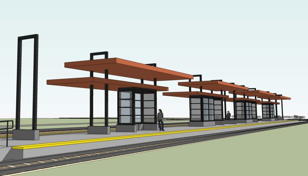
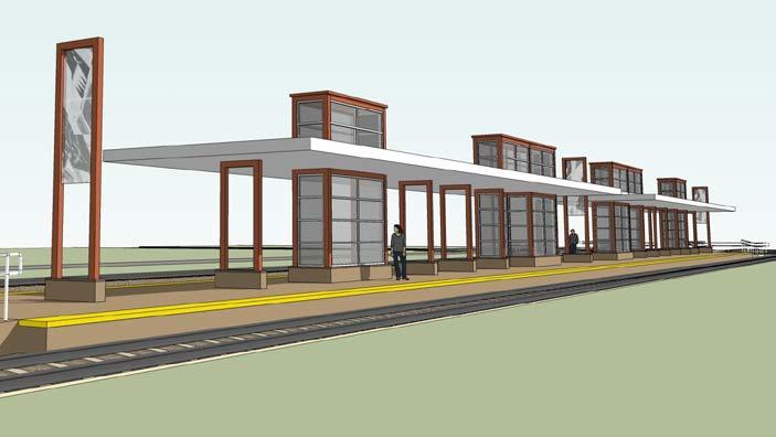
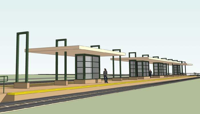
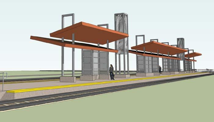
45 Supplemental Draft Environmental Impact Statement SDEIS will evaluate adjustments that may result in significant adverse impact from the proposed project since publication of the DEIS, including: Eden Prairie alignment adjustments Proposed location of the operations and maintenance facility Kenilworth corridor/freight rail alignment 45
46 Next Steps SDEIS publication (conferring with FTA) Notice of Availability starts the 45 day public comment period Document will be made available online and at public locations Open House & Hearings will be held no earlier than 15 days after publication date Comments from DEIS and SDEIS will be responded to in FEIS and through engineering design refinement Mitigation will be included in the FEIS and Record of Decision (ROD) 46
47 Section 4(f) of the Department of Transportation Act 47
48 Section 4(f) Overview Requires consideration of publically owned parks, recreation areas and wildlife refuges and publically or privately owned historic sites during transportation project development Includes coordination with officials with jurisdiction Supplemental draft 4(f) analysis included in SDEIS Updates draft analysis included in DEIS Addresses adjustments made during preliminary engineering 48
49 Section 4(f) Next Steps Coordination with officials with jurisdiction Publish full draft 4(f) evaluation (conferring with FTA) Publish final 4(f) evaluation in Final EIS 49
50 Section 106 of the National Historic Preservation Act 50
51 Section 106 Overview Requires federal agencies to consider effects of project on historic properties Includes consultation with Section 106 consulting parties MN State Historic Preservation Office Cities of Eden Prairie, Minnetonka, Hopkins, St. Louis Park, Minneapolis Hennepin County Minneapolis Park and Recreation Board Three Rivers Park District Kenwood Isles Area Association Cedar-Isles-Dean Neighborhood Association 51
52 Section 106 Next Steps Continue consultation with Section 106 Consulting Parties Make determinations of adverse effects on historic properties impacted by the project Develop Section 106 Agreement Identify measures to avoid, minimize, or mitigate adverse effects 52
53 Design and Engineering Update 53
54 Advancing Design from 30% to 60% Engineering Corridor-wide: Station architecture/integrated public art Streetscape/landscape design LRT track features Roadway and trail details Bridges and tunnels Systems elements Freight rail features ADA features Incorporate changes developed through environmental review process Unique elements: Operations and Maintenance Facility (OMF) in Hopkins Park and ride facilities 54
55 Station Design 55
56 Station Design Scope/Vision Provide architectural consistency with the Green Line and tie the SWLRT corridor together with a corridor-wide design approach Control construction and maintenance costs and learn from past projects Acknowledge the different communities and station sites along the SWLRT corridor Apply one of four identified station types based on previous public input and site observations 56
57 Station Prototypes Landscape Neighborhood Town Square Landmark Landmark 57
58 Four Station Types Landscape Station Understated Neighborhood Station Town Square Station Landmark Station Bold 58
59 Integrated Public Art 59

60 Integrated Public Art Scope Incorporate public art concepts into ongoing station design process Enhance unique identity of stations, aid in passenger wayfinding, promote transit use and community pride Reflect community values and histories Green Line East Bank Station 60
61 Kenilworth Corridor Landscaping 61
62 Kenilworth Landscape Design Scope/Vision Reflect existing setting of the Kenilworth corridor Design vegetation and landscape with trails, freight rail and light rail Ensure quality user experience 62
63 Design: Next Steps Seek appointments to advisory committees Station Art Committees (SAC) Kenilworth Landscape Design/Station Art Committee (KDLC/SAC) Initiate community engagement Hold kick-off meeting with KDLC/SAC Hold open houses on station prototype location and site elements Refine station prototype designs to reflect site and public input Select artists and hold kick-off meeting with the SACs Host public events seeking input on station design and public art design concepts 63
64 Kenilworth Channel Bridge Design Concepts 64
65 Kenilworth Channel Bridge Design Scope Incorporate Section 106 process for historic properties, considerations coordinated with design process Reflect input received from consulting parties Maximize natural light between bridges Create more space for skiers and kayakers Use natural materials/dark colors Consider vegetation and bridge abutments along embankments Meet functional requirements that is tested with structural engineering 65
66 Kenilworth Channel Bridge Design Next Steps Continue review with State Historic Preservation Office (SHPO) and consulting parties Seek public comments at open houses Q
67 Member and Committee Reports / Public Forum 67
68 Next Meeting Tuesday, March 31, 2015 at 6 PM 68

69 More Information Online: Twitter: 69
Transportation Committee
 Transportation Committee Business Item No. 2013-286SW Meeting date: October 14, 2013 For the Metropolitan Council meeting of October 16, 2013 Subject: Southwest Light Rail Transit (Green Line Extension):
Hopkins. Development Guidelines May Overview. Sponsored by: Blake Road Corridor Collaborative City of Hopkins
 Hopkins Blake Road LRT Station Area Development Guidelines May 2015 Sponsored by: Blake Road Corridor Collaborative City of Hopkins Overview Hopkins is a dynamic community of over 17,000 residents located
Southwest Light Rail Transit (LRT) A corridor of opportunity
 A corridor of opportunity") Southwest Light Rail Transit (LRT) A corridor of opportunity Minneapolis Jobs: 151,200 Suburban Jobs: 72,400 Downtown Minneapolis 147,000 emp.* West Calhoun 4,200 emp. Beltline Business Park 6,000 emp.
Southwest Light Rail Transit (LRT) A corridor of opportunity Minneapolis Jobs: 151,200 Suburban Jobs: 72,400 Downtown Minneapolis 147,000 emp.* West Calhoun 4,200 emp. Beltline Business Park 6,000 emp.
Corridor Management Committee. September 29, 2017
 Corridor Management Committee September 29, 2017 1 Today s Topics Chair s Update Proposed Corridor Protection Wall Aesthetic Design Overview Public Outreach Environmental Review Civil Construction Update
Atlanta BeltLine Corridor Environmental Study. Scoping Meeting August 2008
 Atlanta BeltLine Corridor Environmental Study Scoping Meeting August 2008 What Will We Be Discussing Today? Study Overview - How Did We Get Here? - What Is the Study About? - Who Is Involved? - Where Is
Bassett Creek Valley Working Group. October 4, 2017
 Bassett Creek Valley Working Group October 4, 2017 1 Today s Topics Introductions Overview of Design Teams (P+W and WSP) Expertise Working Group Roles and Responsibilities Schedule & Community Engagement
St. Louis Park Wooddale LRT Station Site development guidelines
 St. Louis Park Wooddale LRT Station Site development guidelines November 2013 OVERVIEW St. Louis Park s convenient location as a neighbor to Minneapolis means you re only minutes away from some of the
Land Use and Economic Development 2015 New Starts Executive Summary
 Land Use and Economic Development 2015 New Starts Executive Summary TRANSIT-SUPPORTIVE POLICIES St. Louis Park Minneapolis GROWTH MANAGEMENT STATION AREA PLANNING Hopkins REGIONAL JOB CENTERS TRANSIT-ORIENTED
Chapter 1: Introduction
 Chapter 1: Introduction The Penn Avenue Community Works Corridor Vision and Implementation Framework presents an integrated communitybased vision and a coordinated, long-term implementation framework for
Kenilworth Landscape Design Community Workshop. June 13, 2015
 Kenilworth Landscape Design Community Workshop June 13, 2015 1 Meeting Agenda 8:30 9:00 am: Project presentation 9:00 11:00 am: Small group / table activities 11:00 11:30 am: Reporting and next steps 11:30
Robbinsdale LRT Station. CDI Development Guidelines. August Overview
 Robbinsdale LRT Station August 2018 Overview The City of Robbinsdale may have the coolest opportunity site along the 13 mile stretch of the Bottineau LRT corridor / Blue Line extension. Located a block
Corridor Vision. 1Pursue Minnehaha-Hiawatha Community Works Project. Mission of Hennepin County Community Works Program
 1Pursue Minnehaha-Hiawatha Community Works Project Minnehaha-Hiawatha Community Works is a project within the Hennepin Community Works (HCW) program. The mission of the HCW program is to enhance how the
ROBBINSDALE LRT STATION CDI DEVELOPMENT GUIDELINES
 August 2018 OVERVIEW The City of Robbinsdale has a prime-opportunity site in the middle of the 13 mile stretch of the Bottineau LRT corridor / Blue Line extension. Robbinsdale offers a prominent, vital,
The University District envisions, in its neighborhood
 Envisioning the University District Link Light Rail in Seattle s neighborhoods CIY OF SEALE CONCEP-LEVEL SAION AREA PLANNING RECOMMENDAION RESOLUION # 30165 EXHIBI L Vision 08.2000 he University District
RECOMMENDED GOALS, CONCEPTS, GUIDELINES PUBLIC PARTICIPATION PROGRAM
 2015 RECOMMENDED GOALS, CONCEPTS, GUIDELINES PUBLIC PARTICIPATION PROGRAM THE MARYLAND-NATIONAL CAPITAL PARK AND PLANNING COMMISSION PRINCE GEORGE S COUNTY PLANNING DEPARTMENT SEPTEMBER 24, 2015 INTRODUCTION
RESOLUTION NO. R Refining the route, profile and stations for the Downtown Redmond Link Extension
 RESOLUTION NO. R2018-32 Refining the route, profile and stations for the Downtown Redmond Link Extension MEETING: DATE: TYPE OF ACTION: STAFF CONTACT: Capital Committee Board PROPOSED ACTION 09/13/2018
BROOKLYN PARK / 85TH AVE LRT STATION CDI DEVELOPMENT GUIDELINES DRAFT
 August 2018 Page intentionally left blank The Brooklyn Park Library adjacent to the 85th Ave LRT Station Area. OVERVIEW The Blue Line LRT Extension / Bottineau corridor offers a unique opportunity to leverage
Corridor Background. Defining the Corridor Study Area. Lake Street. 38th Street. 46th Street
 1 Corridor Background Defining the Corridor Study Area Minnehaha Avenue (CSAH 48) and Hiawatha Avenue (MN 55) are parallel diagonal roadways, approximately three blocks apart, that provide two direct arterial
Kenilworth Station Art and Landscape Committee (KSALC) June 25, 2015
 June 25, 2015") Kenilworth Station Art and Landscape Committee (KSALC) June 25, 2015 1 Today s Topics Welcome and Introductions Appoint Committee Co-Chairs Summary of Community Workshop #1 Kenilworth Channel Bridge Design
Kenilworth Station Art and Landscape Committee (KSALC) June 25, 2015 1 Today s Topics Welcome and Introductions Appoint Committee Co-Chairs Summary of Community Workshop #1 Kenilworth Channel Bridge Design
City of Hopkins 2012 Mission and Goals
 City of Hopkins 2012 Mission and Goals Mission Statement Partnering with the community to enhance the quality of life by Inspiring Educating Involving Communicating Collaborative with School District Overcoming
Transportation Working Team Duane Diggs, Co-Chair (VOICE Buffalo) Kelly Dixon, Co-Chair (GBNRTC) Paul Ray, Facilitator (UB Regional Institute)
 Kelly Dixon, Co-Chair (GBNRTC) Paul Ray, Facilitator (UB Regional Institute)") towards a more sustainable Buffalo Niagara Transportation Working Team Duane Diggs, Co-Chair (VOICE Buffalo) Kelly Dixon, Co-Chair (GBNRTC) Paul Ray, Facilitator (UB Regional Institute) Agenda Welcome,
towards a more sustainable Buffalo Niagara Transportation Working Team Duane Diggs, Co-Chair (VOICE Buffalo) Kelly Dixon, Co-Chair (GBNRTC) Paul Ray, Facilitator (UB Regional Institute) Agenda Welcome,
CHAPTER 7: Transportation, Mobility and Circulation
 AGLE AREA COMMUNITY Plan CHAPTER 7 CHAPTER 7: Transportation, Mobility and Circulation Transportation, Mobility and Circulation The purpose of the Transportation, Mobility and Circulation Chapter is to
TOD 101 CREATING LIVABLE COMMUNITIES WITH TRANSIT
 1 CREATING LIVABLE COMMUNITIES WITH TRANSIT What are transit Centered Communities? Benefits of Partnerships to Support and Implement What You Will Learn Portland s Pearl District Your Trainers Today Catherine
WELCOME and introduction
 1 WELCOME and introduction Mobility Hub Locations within Burlington STUDY OVERVIEW STUDY OBJECTIVES The City of Burlington is developing four Area Specific Plans, one for each of Burlington s Mobility
Making Transit Oriented Development Work For Boonton, NJ
 Making Transit Oriented Development Work For Boonton, NJ Bloustein School of Planning and Public Policy Studio Dan Burton Loannie Dao Webster Slater Brandon Williams Ian Watson Maria Laham Nicola Mammes
City of Tacoma Planning and Development Services
 Agenda Item E-1 City of Tacoma Planning and Development Services To: Planning Commission From: Elliott Barnett, Planning Services Division Subject: Tacoma Mall Regional Center Subarea Plan and EIS Meeting
2040 LUP is a part of the Comprehensive Plan and carries the same legal authority. Economic Challenges
 1.1. Guiding Anchorage s Growth Where will new residents settle over the next two decades? Where will people work, shop, and play? Will there be enough room to grow? How will Anchorage look? Will growth
Planning for TOD Implementation at a Corridor Scale
 Planning for TOD Implementation at a Corridor Scale Catherine Cox Blair, Reconnecting America Presentation to DRCOG and the Sustainable Communities Initiative May 14, 2012 What is Reconnecting America?
UPDATE ON THE INDEPENDENCE BOULEVARD AREA PLAN. Citizen Advisory Group Meeting March 3, 2011
 UPDATE ON THE INDEPENDENCE BOULEVARD AREA PLAN Citizen Advisory Group Meeting March 3, 2011 Purpose: Why are we here? To provide an update on the Independence Boulevard Area Plan 1. Overview of the ULI
Promoting Economic Development Through Upfront SEPA Review: Lessons from South Downtown Tacoma
 Promoting Economic Development Through Upfront SEPA Review: Lessons from South Downtown Tacoma 1 This session will focus on the City of Tacoma s South Downtown Subarea Plan and associated Non-Project SEPA
7.0 DRAFT SECTION 4(f) EVALUATION
 EVALUATION") 7. DRAFT SECTION 4(f) EVALUATION 7.1 Background Information and Regulatory Requirements This chapter presents the existing conditions and potential effects on parks, recreation areas, wildlife and waterfowl
7. DRAFT SECTION 4(f) EVALUATION 7.1 Background Information and Regulatory Requirements This chapter presents the existing conditions and potential effects on parks, recreation areas, wildlife and waterfowl
Denver Moves: Transit Task Force
 Insert transit picture Denver Moves: Transit Task Force Meeting #8 October 5, 2017 1. Welcome & Introductions Opening remarks and housekeeping Task Force and audience introductions Upcoming events and
Atlanta BeltLine Subarea 3 Master Plan Update
 Atlanta BeltLine Subarea 3 Master Plan Update April 14, 2018 Workshop Meeting 1 22 miles, connecting 45 neighborhoods 22 MILES of transit 46 MILES of streetscapes and complete streets 33 MILES of urban
Route 110 Alternatives Analysis
 Route 110 Alternatives Analysis Public Meeting #1 December 15, 2014 Source: Town of Babylon Agenda Welcome/Introduction Hon. Antonio A. Martinez Deputy Supervisor, Town of Babylon Update on East Farmingdale
Developer s Program. The Station at East 54
 Developer s Program The Station at East 54 Existing Conditions The Station at East 54 is proposed for a 1.12 acre site at the northeast corner of Hamilton Road and Prestwick Road, tucked between the East
Cultivate Hopkins: Built Environment. Comprehensive Plan Advisory Committee September 13, 2017
 Cultivate Hopkins: Built Environment Comprehensive Plan Advisory Committee September 13, 2017 Four Dimensions of a Sustainable Plan Land Use Urban Design Housing Transportation Resilience Water Resources
FUNDING CORRIDOR REVITALIZATION
 FUNDING CORRIDOR REVITALIZATION Integrated corridor planning for the 21 st Century America Planning Association Annual Conference Atlanta, GA April 27, 2014 Mariia Zimmerman, MZ Strategies, LLC mariia@mzstrategies.com
Urban Planning and Land Use
 Urban Planning and Land Use 701 North 7 th Street, Room 423 Phone: (913) 573-5750 Kansas City, Kansas 66101 Fax: (913) 573-5796 Email: planninginfo@wycokck.org www.wycokck.org/planning To: From: City Planning
JANUARY 19, 2011 CENTRAL AVENUE-METRO BLUE LINE TRANSIT-ORIENTED DEVELOPMENT IMPLEMENTATION PROJECT COMMUNITY FORUM
 CENTRAL AVENUE-METRO BLUE LINE TRANSIT-ORIENTED DEVELOPMENT IMPLEMENTATION PROJECT COMMUNITY FORUM JANUARY 19, 2011 THE MARYLAND-NATIONAL CAPITAL PARK AND PLANNING COMMISSION PRINCE GEORGE S COUNTY PLANNING
A. WHAT IS A GENERAL PLAN?
 I. Introduction A. WHAT IS A GENERAL PLAN? A general plan is the planning guideline for the future of a city. It contains goals and policies which regulate urban development, the protection of the natural
Midtown Greenway Land Use and Development Plan Executive Summary
 Midtown Greenway Land Use and Development Plan Executive Summary Introduction The Midtown Greenway Land Use and Development Plan sets policy direction for land use and development in the Midtown Greenway
New Partners for Smart Growth Conference February 5, 2010
 Dan Stroh, Planning Director City of Bellevue Planning and Community Development Bellevue, WA New Partners for Smart Growth Conference February 5, 2010 Summary of Project Long-range plan update for Bel-Red
University of Saskatchewan CAMPUS MASTER PLAN. Senate Meeting Preliminary Presentation. April 21, 2018 DIALOG ECS DA WATT
 University of Saskatchewan CAMPUS MASTER PLAN Senate Meeting Preliminary Presentation April 21, 2018 DIALOG ECS DA WATT project process presentation agenda Stakeholder Engagement Project Control phase1
Northwest LRT Downtown to. Northwest Edmonton Study. Public Workshops
 Northwest LRT Downtown to Northwest Edmonton Study Public Workshops March 23 & 24, 2010 Welcome Thank you all for attending Welcome Introductions Welcome Our Team s Commitment to You for Tonight To provide
East Bench Master Plan Update
 Community & Economic Development Office of the Director East Bench Master Plan Update To: From: Planning Commission Wayne Mills, Senior Planner Date: November 18, 2015 CC: Re: Nora Shepard, City Planning
Isabel Neighborhood Plan: Alternatives
 Isabel Neighborhood Plan: Alternatives Presented by: Lori Parks, Associate Planner February 2, 2015 Agenda 1. Background on BART to Livermore 2. Isabel Neighborhood Plan 3. Alternative Scenarios 4. General
Tyvola & Archdale Transit Station Area Plan. June 5, 2008
 Tyvola & Archdale Transit Station Area Plan Second Public Meeting June 5, 2008 Presentation Outline 1. Purpose and Process 2. Station Area Overview 3. Plan Recommendations 4. Comments Received and Proposed
Infrastructure Engineering Planning Construction Suite 300 Minneapolis, MN Tel: Fax:
 Infrastructure Engineering Planning Construction 701 Xenia Avenue outh uite 300 Minneapolis, MN 55416 Tel: 763-541-4800 Fax: 763-541-1700 Memorandum To: Minnehaha Creek Watershed District Board From: Tony
Point A Point B Point C Point D. City of Hapeville Public Meeting July 25, 2017
 City of Hapeville Public Meeting July 25, 2017 Fulton County Transit Master Plan Overview Following last year s ¾-cent TSPLOST effort, the Mayors of the 14 Cities outside of Atlanta and the Fulton County
This chapter describes the purpose of the Plan, introduces how the Plan is organized and provides contextual background for the Plan.
 Chapter 1: INTRODUCTION Purpose of a Comprehensive Plan The 2040 Comprehensive Plan establishes Medina s vision as a community and sets goals and objectives which guide future decisions and policies. The
POLICY ADVISORY COMMITTEE
 July 26, 2018 POLICY ADVISORY COMMITTEE ENVIRONMENTAL ANALYSIS PHASE Agenda 1. Welcome and introductions. 2. Overview of project activities. 3. Community Advisory Committee update. 4. Public engagement
Plan Overview. Manhattan Area 2035 Reflections and Progress. Chapter 1: Introduction. Background
 Plan Overview The Manhattan Urban Area Comprehensive Plan (the Comprehensive Plan) is a joint planning initiative of the City of Manhattan, Pottawatomie County, and Riley County. The 2014 Comprehensive
REVIEW AND EVALUATION OF REGIONAL LAND USE
 REVIEW AND EVALUATION OF REGIONAL LAND USE AND TRANSPORTATION SCENARIOS #220831 Environmental Justice Task Force October 7, 2014 VISION 2050 Process Development of Guiding Vision for Land Use and Transportation
Corridor-Level Approaches to Creating Transit-Oriented Districts
 Corridor-Level Approaches to Creating Transit-Oriented Districts Dena Belzer Strategic Economics and Center for Transit-Oriented Development August 2011 5-year old partnership dedicated to improving practice
BeltLine Corridor Environmental Study
 BeltLine Corridor Environmental Study Joint TAC and SAC Meeting December 8, 2008 What We Will Discuss Today Outreach and Agency Coordination Scoping Results Existing Conditions Historical and Archeological
Town Center (part of the Comprehensive Plan)
") Town Center (part of the Comprehensive Plan) Mercer Island Town Center Looking North (2014) In 1994, a year-long process culminated in a set of design guidelines and code requirements for the Town Center
Town Center (part of the Comprehensive Plan) Mercer Island Town Center Looking North (2014) In 1994, a year-long process culminated in a set of design guidelines and code requirements for the Town Center
Welcome to the Oakridge Centre Open House
 Welcome to the Oakridge Centre Open House Why is the City hosting this event? This open house is to inform you of a rezoning application submitted to the City of Vancouver to amend the existing CD-1 (Comprehensive
TRANSIT-ORIENTED DEVELOPMENT POLICY DRAFT. City Planning and Development Department Kansas City, Missouri
 TRANSIT-ORIENTED DEVELOPMENT POLICY DRAFT City Planning and Development Department Kansas City, Missouri What is Transit Oriented Development (TOD)? Development that focuses land uses around a transit
Streets, Connectivity & Built Environment Working Group August 2, 2017
 Streets, Connectivity & Built Environment Working Group August 2, 2017 DOWNTOWN OAKLAND SPECIFIC PLAN WELCOME Streets, Connectivity & Built Environment Working Group Social Equity Meeting August 2, 2017
Chapter 4. Linking Land Use with Transportation. Chapter 4
 Chapter 4 Linking Land Use with Transportation Chapter 4 59 Chapter 4 Linking Land Use with Transportation Community Design and Transportation Program Introduction Since the 1950s, the predominant development
Transportation. Strategies for Action
 Transportation A major priority for the Overlake Neighborhood is to develop a multimodal transportation system. To achieve this system, a balance has to be found among travel, circulation and access needs;
West Broadway Transit Study Initial Screening of Alternatives Memo
 West Broadway Transit Study Initial Screening of Alternatives Memo 5/22/2015 Prepared by the SRF Consulting Group Team for Table of Contents Purpose... 1 Methodology... 1 Screening... 5 Screening Criteria...
Moody Centre Station TOD Area Today
 Moody Centre Station TOD Area Today WHAT IS a transit-oriented Murray Street development area? A Transit-Oriented Development (TOD) Area is a dense, walkable residential and commercial area built to support
Equitable Growth Through TOD Planning
 Equitable Growth Through TOD Planning Community Meeting # 2 November 2017 Goals Objectives Extend investment from downtown Connect neighborhoods physically and economically Enhance places based on local
South Davis County COMMUNITY SPOTLIGHT
 South Davis County COMMUNITY SPOTLIGHT Davis/SLC Community Connector Bus Rapid Transit line connecting SLC & Davis County RTP Phase 1 Project Generate 3,100 average weekday riders Relieve congestion on
Chapter 1.0 Introduction
 Chapter 1.0 Introduction 1.1 Background The North Metro commuter rail line is part of the RTD FasTracks regional transit system expansion program to build more than 100 miles of rail transit throughout
Community Engagement Committee Meeting #1 December 10, :30pm-8:30pm
 Community Engagement Committee Meeting #1 December 10, 2014 6:30pm-8:30pm Welcome and Introductions Dana Murdoch Minneapolis Park and Recreation Board Project Manager Ryan French Walker Art Center Director
Mississippi Skyway Preliminary Engineering Report
 EXECUTIVE SUMMARY Mississippi Skyway Preliminary Engineering Report CITY OF RAMSEY, MINNESOTA DECEMBER 2014 City of RAMSEY EXECUTIVE SUMMARY Project Need and Intent The Mississippi Skyway pedestrian bridge
1 October Dear Citizens of Charlotte and Mecklenburg County,
 1 October 2011 Dear Citizens of Charlotte and Mecklenburg County, As co-chairs of the Center City 2020 Vision Plan Steering Committee, we are proud to present the Center City 2020 Vision Plan, which sets
2035 General Plan Update and Belmont Village Specific Plan. Joint Study Session with the City Council and Planning Commission April 12, 2016
 2035 General Plan Update and Belmont Village Specific Plan Joint Study with the City Council and Planning Commission April 12, 2016 Agenda 1. Welcome and Introductions 2. General Plan Update Status of
North Fair Oaks Community Plan Summary and Information
 North Fair Oaks Community Plan Summary and Information WHAT IS THE NORTH FAIR OAKS COMMUNITY PLAN? The North Fair Oaks Community Plan is part of the San Mateo County General Plan, and establishes policies
Welcome! Please sign-in and participate in the activities in the registration area before finding your seat. Thank you!
 Welcome! Please sign-in and participate in the activities in the registration area before finding your seat. Thank you! Planning Kickoff July 31, 2018 University of Baltimore Public Planning Kick-off Agenda
Status Report: MD 355 Project
 Status Report: MD 355 Project OCTOBER 2006 M-NCPPC MONTGOMERY COUNTY PLANNING DEPARTMENT Summary of Community Comments, and break to the Results of the MD 355 Participation Session Brookside Gardens -
Don Mills Crossing Study and Celestica Lands Development Application Community Meeting, Open House, and Breakout Discussions
 Consultation Summary Don Mills Crossing Study and Celestica Lands Development Application Community Meeting, Open House, and Breakout Discussions This report is not intended to provide a verbatim transcript
Northwest Rail Corridor and US 36 BRT Development Oriented Transit Analysis 4.4 STATION AREA FINDINGS
 4.4 STATION AREA FINDINGS Each station is different, and each one requires a separate set of recommendations based on the vision for the site. This section outlines an initial TOD strategy and recommendations
THE 355/270 CORRIDOR:
 THE 355/270 CORRIDOR: Strategic Ideas for Sustaining a Livable Work Place Project Summary ACCESS LIFE DESIGN HEALTH WORK Montgomery County Planning Department The Maryland-National Capital Park and Planning
Concord Community Reuse Project Goals and Guiding Principles. Overarching Goals (OG)
") Concord Community Reuse Project Goals and Guiding Principles Overarching Goals (OG) No priority is implied by the order of presentation of the goals and guiding principles. Overarching goals for the Concord
Concord Community Reuse Project Goals and Guiding Principles Overarching Goals (OG) No priority is implied by the order of presentation of the goals and guiding principles. Overarching goals for the Concord
Blueprint Denver Task Force Meeting #
 Blueprint Denver Task Force Meeting #1 6.23.16 1. Welcome and Introductions Your name and affiliation Name 1 thing you love about Denver Name 1 thing you d change about Denver All in 30 seconds! Ready,
Chapter 2: Vision, Goals and Strategies
 Chapter 2: Vision, Goals and Lake Elmo Today & Tomorrow Comprehensive Plan 2040 2 VISION, GOALS & STRATEGIES - DRAFT 4-6-2018 INTRODUCTION Comprehensive Plan Purpose Perhapse the most important objective
D-O LRT Zoning Discussion. Chapel Hill Boards & Commissions October 16, 2017
 D-O LRT Zoning Discussion Chapel Hill Boards & Commissions October 16, 2017 Update on Overall D-O LRT Station Area Initiative Objectives Design and educate on principles of Good Transit-Oriented Development
City Council and Planning & Zoning Commission Workshop March 20, 2018
 City Council and Planning & Zoning Commission Workshop March 20, 2018 Completed July 27, 2017 Kick-Off Sept 13 Built Environment Nov 8 Natural Environment Jan 10, 2018 Economic Environment Feb 7 Social
Silver Line CPAM UPDATE. Transportation and Land Use Committee October 14, 2016
 Silver Line CPAM UPDATE Transportation and Land Use Committee October 14, 2016 Purpose Recap Project History and Map Changes Provide Overview of CPAM Components Discuss Transportation Impacts Discuss Fiscal
NORTH CLAYMONT AREA MASTER PLAN COMMUNITY WORKSHOP #1 FEBRUARY 3, 2016
 NORTH CLAYMONT AREA MASTER PLAN COMMUNITY WORKSHOP #1 FEBRUARY 3, 2016 1. Introduction To the team and to the Plan Planning Partners The Claymont Community WILMAPCO New Castle County Claymont Renaissance
5 EIS Process, Content, and Exhibits
 5 EIS Process, Content, and Exhibits 5.1 Draft and Final Environmental Impact Statements The recent SW LRT process began with a comprehensive analysis of alternative corridors, the results of which form
Future Proposed Development
 Future Proposed Development on and around Link light rail s Capitol Hill Station Meeting September 24, 2012 Tonight s Agenda 6:00 pm Open House 6:30 pm Introductions Richard Conlin, City of Seattle Councilmember/Sound
The Need to Develop a Transit Ready Community
 Evaluation & Appraisal Report (EAR) Major Issue # 6 The Need to Develop a Transit Ready Community July 3, 2007 EAR Major Issue # 6 Transit Ready Existing Comp Plan policies apply only to Indiantown Road:
Downtown Elkton Station Area Plan, Elkton, MD. Difficult enough to get support for new starts challenge to fund Houston transit
 Difficult enough to get support for new starts challenge to fund Houston transit More difficult to build Community Support for dense development at station areas Major Concerns: Traffic, Property values,
PLAN ELEMENTS WORKSHOP. April 5, 2016
 PLAN ELEMENTS WORKSHOP April 5, 2016 needs more housing. But there is no one-size fits-all solution. Every neighborhood has its own character. In some places, density is not only appropriate it is badly
REGIONAL ACTIVITY CENTER
 DRAFT REGIONAL ACTIVITY CENTER 70 EAST BENCH MASTER PLAN DRAFT 06 Introduction The East Bench Regional Activity center is comprised of large educational, research, medical, and employment centers. These
PRINCE GEORGE S PLAZA TRANSIT DISTRICT DEVELOPMENT PLAN AND TRANSIT DISTRICT OVERLAY ZONE UPDATE
 PRINCE GEORGE S PLAZA TRANSIT DISTRICT DEVELOPMENT PLAN AND TRANSIT DISTRICT OVERLAY ZONE UPDATE UNIVERSITY PARK TOWN LISTENING SESSION JUNE 12, 2014 Prince George s County Planning Department The Maryland-National
Glenborough at Easton Land Use Master Plan
 Vision Statement Sunrise Blvd. Hazel Ave. Prairie City Rd. Gencorp Property Lincoln Regional Airport 1.0 VISION STATEMENT The identifies City of the principles, goals, policies, and standards Lincoln that
Blue Line LRT Extension
 v e Noble Pkwy Noble Pkwy Xerxes Ave N Shingle Creek Penn Ave N Penn Ave N Fremont Ave N Lyndale Ave N S Washington Ave University Ave NE Blue Line LRT Extension LIGHT RAIL PLATFORM AND STATION DESIGN
3. Endorse the LRT vision in transforming Surrey into Connected-Complete-Livable communities, and more specifically, the official vision statement:
 CORPORATE REPORT NO: R038 COUNCIL DATE: February 20, 2017 REGULAR COUNCIL TO: Mayor & Council DATE: February 16, 2017 FROM: General Manager, Engineering FILE: 8740-01 SUBJECT: Surrey Light Rail Transit
Issues, Challenges & Opportunities
 Below is a summary of issues, challenges, and opportunities relating to the revitalization of Downtown Romeoville and potential development of the Village s East Side TOD Area. Current Issues & Challenges
Plano Tomorrow Vision and Policies
 Plano Tomorrow Vision and Policies PLANO TOMORROW PILLARS The Built Environment The Social Environment The Natural Environment The Economic Environment Land Use and Urban Design Transportation Housing
METRO Gold Line BRT CBAC Meeting. August 23, 2018
 METRO Gold Line BRT CBAC Meeting August 23, 2018 1 Today s Topics Introductions Corridor Management Committee Update Public Engagement Update History of Alignment Project Scope Discussions Upcoming CBAC
Southwest LRT Potential Cost Reduction Scenario A Western End at Southwest Station
 Southwest LRT Potential Cost Reduction Scenario A Western End at Southwest Station Cost Category: Range Potential Cost Reduction Ridership (In Millions) Delta Cost ID Description (In Millions) Low High
KCATA Transit Oriented Development Initiatives
 KCATA Transit Oriented Development Initiatives KCATA: Regional Transportation Authority Created by bi-state compact Approved by Congress 7 County service area Quasi-governmental with broad powers Power
Urban Design Manual PLANNING AROUND RAPID TRANSIT STATIONS (PARTS) Introduction. Station Study Areas
 Introduction. Station Study Areas") 111111 PLANNING AROUND RAPID TRANSIT STATIONS (PARTS) Introduction The ION rapid transit system will link Waterloo, Kitchener and Cambridge through a central transit corridor (CTC). There are a number
111111 PLANNING AROUND RAPID TRANSIT STATIONS (PARTS) Introduction The ION rapid transit system will link Waterloo, Kitchener and Cambridge through a central transit corridor (CTC). There are a number
Embrace Green Urban Space:
 1 Embrace Green Urban Space: Parks/Green Space as Vital to Urban Livability Jenna Fletcher The Trust for Public Land LUAC November 15, 2012 2 The Trust for Public Land conserves land for people to enjoy