LAND TO THE NORTH OF ASTON ROAD HADDENHAM
|
|
|
- Julia Eaton
- 5 years ago
- Views:
Transcription


1 LAND TO THE NORTH OF ASTON ROAD HADDENHAM Design & Access Statement Incorporating Design Code IN SUPPORT OF RESERVED MATTERS APPLICATION PHASE 1 & 2 May 2017


2 FOREWORD ABOUT DANDARA Emerging over the last two decades as one of the UK s most diverse property developers, the Dandara Group is now renowned for award winning quality and landmark buildings. With a wealth of experience, encompassing both high end residential and commercial developments, Dandara has established a reputation of versatility and vision. We are passionate about quality, which is why we undertake every aspect of the development process ourselves, from land buying and planning, to design, build and sales. We know just what it takes to make a house a home. We invest in research and development and spend time talking with prospective home buyers to create practical, comfortable homes that provide quality and value for years to come.
3 CONTENTS INTRODUCTION OUTLINE PLANNING APPLICATION 01 PLANNING APPLICATION PROPOSAL 03 SITE LAYOUT PROPOSAL 05 CONSTRAINTS & OPPORTUNITIES 07 DESIGN CODE DESIGN FRAMEWORK PRINCIPLES 11 DESIGN CONCEPT 13 INTEGRATING INTO THE NEIGHBOURHOOD 01. Connections Facilities and services Public transport Meeting local housing requirements 23 CREATING A PLACE 05. Character Working with the site and its context Creating well defined streets and spaces Easy to find your way around 41 STREET & HOME 09. Streets for all Car parking Public and private spaces External storage and amenity space 53 SUMMARY BUILDING FOR LIFE 12 SUMMARY 57 DESIGN CONCEPT SUMMARY 59
4
5 INTRODUCTION


6 OUTLINE PLANNING APPLICATION 1. Church can be seen from the entrance on Stanbridge Road 2. Existing hedgerow along the centre of the site 3. Southern part of the site looking northwards 4. Houses along the northern boundary 5. Entrance to site across Stanbridge Road The Approved Application In February 2015, AVDC granted outline planning permission (ref: LPA 14/02666/ AOP) for a new development of up to 280 dwellings along side associated parking, landscaping, public open space and off site highway works. The application also included 35 retirement properties and a burial ground. The outline application Design & Access Statement The Site The Land to the North of Aston Road forms a logical and coherent addition to the village which bounds the site to the north and west. The village is well served with key local amenities such as: primary school, village hall, sports, leisure facilities, and garden centre together with public houses and key local shops. included an Illustrative Master plan for the site that was produced following design framework principles. This identified a range of design elements including key spaces, building frontages, urban structure, vehicle routes and public realm. The Reserved Matters application has sought to retain these key design principles within the final proposal. 1

7 OUTLINE PLANNING APPLICATION Outline Application Boundary showing views of the Outline application site The approved Outline Illustrative Master plan 2


8 PLANNING APPLICATION PROPOSAL Jan 2017 Feb 2017 March 2017 April 2017 Design Evolution: The above images show the evolution of the development informed by design reviews and consultation with AVDC Reserved Matters Application This Design and Access Statement has been prepared to support the submission of a Reserved Matter application which seeks planning permission for Phase 1 and 2 of the residential development on the land to the north of Aston Road in Haddenham. The preparation of this document is in conjunction with the guidance notes provided by CABE in Design and access statements How to write, read and use them The purpose of this document is to set out the design evolution of the application proposal. It demonstrates how the scheme has advanced whilst complying with supporting best practice principles and recommended design guides. This document outlines the vision, key design principles, access, movement, layout and appearance of the proposed neighbourhood. This document also explains how the Outline design principles have evolved into a detailed proposal and should therefore be read in conjunction with the Design & Access Statement for the Outline planning application and the Planning Supporting Statement. The design has evolved following numerous consultations with Aylesbury Vale District Council, Bucks County Council, and Haddenham Parish Council. Through preapplication discussions the proposal has evolved into the development which forms this Reserved Matters application. Whilst this Reserved Matters application is for Phase 1 and 2 of the development only, this Design and Access Statement will consider elements of the scheme as a whole. 3


9 PLANNING APPLICATION PROPOSAL Site Location Plan Outline Application Boundary Phasing Plan Site Location Plan Phasing Plan Taken from Google Earth Outline Application Boundary Phase 1 & 2 Reserved Matters Boundary Phase 3 & 4 4

10 SITE LAYOUT PROPOSAL The Proposed Illustrative Site Layout Proposed Illustrative Site Layout The proposed Layout Plan shows the arrangement of buildings on the site. It also shows the relationship between built form and open spaces as well as paths and road network. The key elements to note is the Central Green space which acts as the main focal point to the scheme. Other points to note are the diverse style, sizes, clustering of the proposed buildings and how their arrangement define the space in which they sit. The public open spaces are a key element to the scheme, providing ample play space, visual amenity and permeability. The natural landscape features have been retained where possible. The road network and new pedestrian links are well connected throughout the site making movement around the scheme clear. The proposed illustrative site layout accommodates a total of 280 units. However, the number of units provided for the Reserved Matters Application for Phase 1 & 2 of the Proposal equates to a total of 143 new homes. 1 Bedroom Apartment 2 Bedroom House 3 Bedroom House 4 Bedroom House 5 Bedroom House Total Private Market Housing Affordable Rent Shared Ownership Total (Phases 1 & 2) The Tenure Mix Provisions for Phase 1 & 2 5


11 SITE LAYOUT PROPOSAL Extract showing the Central Green Space Extract showing the Public Open Space to the south western corner Extract showing the Neighbourhood Area Equipped for Play (NEAP) situated towards the north western part of the site Extract showing provided facilities including a Cricket Pitch and allocated space for a Pavilion 6

12 CONSTRAINTS & OPPORTUNITIES Constraints Plan Neighbouring residential proprieties Public Right of Way Oil Pipe Sewer Pipe Retained Hedgerows Site Analysis This section describes the analysis of the site and its surroundings and how this has shaped the concept upon which the development proposal is based. The analysis for the Constraints and Opportunities have directly informed the proposed site layout. These were formed following the gathering of information during the Outline proposal phase and have been carried across during evaluation at the Reserved Matters stage. Easements The site is constrained by numerous utility easements. These physical constraints create nondevelopable paths cutting across the site. This includes an oil pipeline towards the south eastern section of the site as well as a sewer easement that cuts across the middle of the site. Site Topography The site gently slopes from the north to the south east of the site. This forms an opportunity to create a natural way of disposing surface water towards the south-eastern corner through the proposal of an attenuation pond. Existing Hedgerow and Trees There are a number of trees and hedgerows on the site, some of which are retained. The proposal seeks to incorporate these within the development by integrating them into the landscape strategy for the overall site. Large field boundaries are found across the site in the form of hedgerows that will be retained where possible and enriched with native planting. 7

13 CONSTRAINTS & OPPORTUNITIES Opportunities Plan Public Open Space Countryside Site Entrance Long Views Links with surrounding community Existing links The two existing public rights of way allow for additional connections into the site from its local surroundings. Both footpaths will be retained. The site offers an opportunity to provide high quality public open spaces which connect into the network of public rights of way, allowing the development to legibly integrate with its surrounding context. New footpaths are proposed to connect to the existing public rights of way creating further connections and encouraging pedestrian and cycle movement throughout the site. Adjoining Village The existing residential dwellings found towards the Northern edge of the site limit opportunities with the design proposal. An existing row of houses here means that there is a restriction to the size of the units in terms of storey height. Furthermore, the orientation of any proposed dwelling along this edge are restricted and will therefore be north facing frontages. Key Views The site offers a great deal of views of surrounding landscaping towards the southern and western parts. Views towards the church can also be seen by the entrance to the site situated by Stanbridge Road. Open Space The site consists of generous amounts of open spaces. These spaces have opportunities to create parkland and play areas. They also have the potential to connect the areas with its wider vicinity through the existing links found on the edges of these spaces. 8
14
15 DESIGN CODE


16 Page 1 DESIGN FRAMEWORK PRINCIPLES Design Guides The qualities of character, continuity, enclosure of the public realm, ease of movement, legibility, adaptability, diversity, security and services are the basis for all successful developments and are reflected in a variety of national guidance documents including the following: Secured by Design Version 1; February 2016 By Design, 2000 Manual for Streets 2, 2010 Open Space Strategies, 2009 Secured by Design, 2016 Together with Aylesbury Vale District Local Plan, the Haddenham Neighbourhood Plan 2016 and Recycling and Waste Advice Note for Developers 2015, these documents have formed the basis of the Design Concept and Design Framework Principles for the scheme. These documents have been used as guidance tools throughout the design process. The development proposal s compliance with key planning policies and supplementary planning guidance is set out in more detail within the Planning Supporting Statement which accompanies the application. Recycling and Waste: Advice note for developers 2015 April 2015 Design Framework Principles Based on the above guidelines, general design framework principles and objectives have been outlined in order to form the Design Concept. These are four objectives that establish the vision for the development and have been used as a tool throughout the design process. These are: REFLECTION: A proposal that takes strong aesthetic references from local vernacular for design and materials Deliver a community that sits within the landscape and relates better to it Incorporate sustainable building techniques and materials RESPONSIVE Retain existing landscape character Preserve and enhance existing ecological value Maximise the opportunities given by the site Develop a design that has regard to improving accessibility to existing facilities Utilise the constraints of the site to dictate the form of the development DISTINCTION: Design new landscaped spaces establishing a transition between the development and the surrounding area Maintain the existing views that the site offers CONNECTIONS: A development proposal that allows for visual and physical permeability and connections throughout the site Maximise the potential of the site in terms of a sustainable transport approach Define a series of open spaces that allow easy and clear navigation Create a variety of house types and sizes Create a sense of place for those that live there, and an environment that fosters a sense of neighbourhood and community Link to existing areas and wider neighbourhood Develop network of vehicular and pedestrian access points Create a safe neighbourhood that ensures that there is natural surveillance to all elevations. 11

17 DESIGN FRAMEWORK PRINCIPLES Building For Life 12 Dandara are committed to excellence in design and place making. Through a careful design-led approach we aim to create and deliver a successful and exemplar development. Our approach to this proposal has been tested against the Building for Life 12 document (2015) to demonstrate that it meets with our established Design Framework Principles highlighted in this section. This Design and Access Statement has therefore been informed by the Building for Life 12 principles. BF12 is endorsed by government and is the industry standard for well-designed homes and neighbourhoods. It can help local communities, local authorities and developers work together to create a good place to live. This document will apply the 12 outlined urban design principles recommended by Building for Life 12 as a guiding tool to demonstrate that the scheme has met with a high standard of design. These principles are outlined in the form of questions throughout the document and answered by demonstrating how the development meets with the BF12 principles as well as our own framework objectives. Below are the BF12 principles that will be discussed throughout the document. Building for Life 12 1 Connections Does the scheme integrate into its surroundings by reinforcing existing connections and creating new ones, while also respecting existing buildings and land uses around the development site? 2 Facilities and Services Does the development provide (or is it close to) community facilities, such as shops, schools, work places, parks, play areas, pubs or cafés? 3 Public transport Does the scheme have good access to public transport to help reduce car dependency? 4 Meeting local housing requirements Does the development have a mix of housing types and tenures that suit local requirements? 5 Character Does the scheme create a place with a locally inspired or otherwise distinctive character? 6 Working with the site and its context Does the scheme take advantage of the existing topography, landscape features (including water courses), trees and plants, wild life habitats, existing buildings, site orientation and micro-climate? 7 Creating well defined streets and spaces Are buildings designed and positioned with landscaping to define and enhance streets and spaces and are buildings designed to turn street corners successfully? 8 Easy to find your way around Is the development designed to make it easy to find your way around? 9 Street for all Are streets designed in a way that encourage low vehicle speeds and allow them to function as social spaces? 10 Car parking Is resident and visitor parking sufficient and well integrated so that it does not dominate the street? 11 Public and Private Spaces Will public and private spaces be clearly defined and designed to have appropriate access and be able to be well managed and safe to use? 12 External Storage and amenity space Is there adequate external storage space for bins and recycling, as well as vehicles and cycles? 12

18 DESIGN CONCEPT DISTINCTIVE: RESPONSIVE: A naturally evolved scheme that has been shaped by its constraints and turned them into opportunities. 13


19 DESIGN CONCEPT CONNECTIONS: Creating a scheme with strong permeable views and links both within the development and the wider context REFLECTION: 14
20
21 I N T E G R A T I N G I N T O T H E N E I G H B O U R H O O D


22 CONNECTIONS 1.1. Neighbourhood Connections Train Line Principle Roads A Roads Site Boundary Proposed Road Network 1 Connections Does the scheme integrate into its surroundings by reinforcing existing connections and creating new ones, while also respecting existing buildings and land uses around the development site? 1.2. View of A4129 Thame Rd. Image 1.1. & 1.2 Taken from Google Earth Integrate into surroundings The new proposed development adjoins the residential district in Haddenham and is well connected to the existing local highways network and public transport links. The site lies a short driving distance from the A418 to the north of the site as well as a short drive to the A4129 to the south. The A418 is 22.3 miles away from the M25, taking approximately 30 minutes to drive. The A4129 is 23.6 miles away from the M40 taking approximately 27 minutes to drive. These roads offer ideal connections to nearby cities including London and Oxford. Proposed roads within the new development will offer road links from two separate access points; Stanbridge Road to the east of the site and Aston Road to the south of the site. This will allow for alternative route options and increased connectivity to the surrounding network of roads. 17

23 01. CONNECTIONS Proposed Road network Primary Roads Secondary Roads Tertiary Roads Movement The connections and established links within the layout have evolved from a constraints and opportunities plan undertaken during site analysis. The alignment of the vehicular, cycle and pedestrian routes through the scheme were agreed under the Outline planning permission. A primary route through the site was established to connect the two approved access points. Streets have been designed to create paths for both the pedestrians, cyclists and vehicles. The layout has been designed to minimise cul-de-sacs and maximise permeability through the site. Permeability & Connectivity The master plan build upon existing connections whilst establishing new connections to create improved connectivity and permeability through the site and out to the surrounding areas. The design framework established under the outline planning application ensures the connectivity of routes are firmly established within the fabric of the design. The primary road through the site has the open central green space at the heart of the layout which acts as the defining feature of the site. Secondary streets also lead onto the central green whilst the tertiary routes have a domestic character where vehicular movement is reduced to provide quieter environments with greater privacy. Access The movement network within the site will be provided for all potential users. It will maximise accessibility to all parts of the site, be at an appropriate gradient and will be suitably well lit. Changes in level, including kerbs have been kept to a minimum between the pedestrian and highway zones. This ensures ease of access throughout the scheme whilst providing clear definition and distinction between shared surfaces and public roads, achieved through textural/material changes and shaped surfaces. 18

24 FACILITIES AND SERVICES Commercial Housing Sports Church School Transport Medical Centre Fire Station Park Fields 2.1. Land Use upgrading of existing public rights of way, establishment of 2 Facilities and Services new routes and enhancements to public transport services. Image Taken from Google Earth Existing Community Facilities The application site is within walking distance of the village centre which provides a wide range of public amenity, shops, leisure and sporting facilities. The local village is easily accessible by public footpaths. Does the development provide (or is it close to) community facilities, such as shops, schools, work places, parks, play areas, pubs or cafés? Access to Haddenham will be further improved by the Proposed Community Facilities As part of the Section 106 legal agreement, the final development will accommodate a Cricket Pitch, Cricket Nets, a Sports Pavilion with associated parking, a LEAP, a NEAP and a burial ground. The Pavilion will provide flexible use and can therefore be used for other community purposes. These new facilities are located to be accessible not only to the new development but also serve the existing communities surrounding the application site. The proposed development allows for the delivery of two bus stops associated with an improved services being discussed with the Parish Council. 19


25 02. FACILITIES AND SERVICES Haddenham Community Junior School 2.3. Haddenham Medical Centre 2.4. Haddenham St Mary s CE School 2.5. Haddenham & Thame Parkway train station 2.6. Retail Park along Pegasus Way 2.7. Local shops on Strokes Croft Road 2.8. Haddenham Fire Station 20
26 PUBLIC TRANSPORT 3.1. Proposed links Potential future Bus stops Potential future bus route Cycle Route Proposed foot-links Mon&Fri 1 journey per day Wed&Fri 1 journey 3 Public transport Does the scheme have good access to public transport to help reduce car dependency? Existing Transport Links The application site is within close proximity to numerous public transport facilities. Haddenham & Thame Parkway train station is situated approximately 1 mile away from the site. Trains currently include connections that run to London Marylebone twice every hour with a journey time of 40 minutes. Other connections include to Banbury and Oxford which also have frequent train services with journey times of 30 minutes. At present there are four bus services (numbers 111, 112, 274 and 280) with stops located near the application boundary. These buses offer services to nearby centres such as Oxford as well as to the Haddenham Thame Parkway train station. Buses run at the following times: per day, Mon to Sat 1 journey per day, 280 every 20 min Monday to Saturday & every 60min on Sundays. Alternative Travel Links Pedestrian and cycle access has been carefully considered to provide safe and meaningful access throughout the site. Footpaths have been proposed throughout the scheme including along the main spine road. Cycle and bus routes have been introduced within the development, creating connections between identified key areas and to the surrounding areas the importance of spaces within the proposed site layout. The spine road has been designed to accommodated a potential new bus route through the new development. This will serve all phases and the existing neighbourhood. The new bus service will link the site to the wider area for future and existing residents. The bus will be accessed through Aston Road and Stanbridge Road, connecting through the Central Green along the Primary road. 21

27 03. PUBLIC TRANSPORT Local train station and train line 3.3. Local bus routes and bus stops 3.4. Cycle Routes Image Taken from Google Earth 22

28 MEETING LOCAL HOUSING REQUIREMENTS 4.1. Plan showing the overall House Type Mix 4 Meeting local housing requirements Does the development have a mix of housing types and tenures that suit local requirements? Local Housing Requirements The layout provides a range of houses across the site and will provide a mix of homes for those starting families, downsizing or buying their first home. The range of houses can be seen in figure 4.1. The housing mix has been informed by a range of evidence base documents prepared to inform the emerging Local Plan. 2 BED BUNGALOW (over 55 s) 756sqft 2 BED BUNGALOW (over 55 s) 975sqft 3 BED HOUSE (over 55 s) 1005/998sqft 3 BED HOUSE 1005/998sqft 3 BED HOUSE 1104/1110sqft 4 BED HOUSE 1273 sqft 4 BED HOUSE 1452 sqft 4 BED HOUSE 1603sqft 4 BED HOUSE 1758 sqft 5 BED HOUSE 1956 sqft 2 BED HOUSE 764 sqft 3 BED HOUSE 883 sqft 4 BED HOUSE 1076 sqft 1 BED FLATS 458 sqft Affordable Housing The provision of 35% affordable housing will have been designed to be integrated with tenure blindness and a range of house typologies are provided for rent and shared ownership. The affordable housing shall be constructed in accordance with HCA Design Quality Standards and will achieve minimum HQI scores as follows; Unit size - 41; Internal layout 32; Noise, services & Light 22; Building for Life 12. Elderly Housing The scheme has been designed to provide homes for the elderly. The overall scheme will comprise 35 elderly persons dwellings as required by the Section 106 legal agreement. However, Phases 1 and 2 will contain a total of 19 elderly persons dwellings which comprises a mix of bungalows and traditional houses. This scheme requires that the primary occupants of these homes are by those aged 55 years or over. 23

29 04. MEETING LOCAL HOUSING REQUIREMENTS Plan showing the Tenure Mix Private Tenures Affordable Tenures 4.3. Plan showing the Over 55 s dwellings 2 Bed detached bungalow 2 Bed semi-detached bungalow 3 Bed semi-detached/terraced house 24
30
31 C R E A T I N G A P L A C E


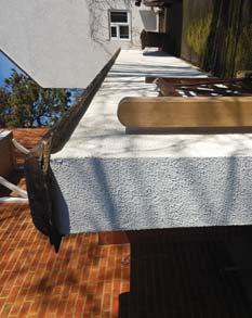
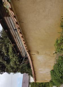
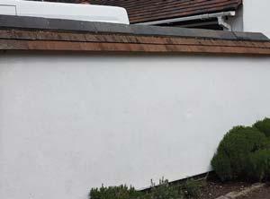
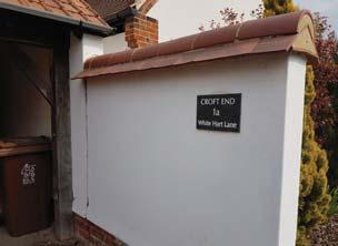
32 CHARACTER 5.1. Wychert Wall Plan 5 Character Does the scheme create a place with a locally inspired or otherwise distinctive character? 5.2. Proposed Wychert Wall by the entrance of Stanbridge Road Wychert Walls Wychert walls are traditional structures found across the village of Haddenham. These walls are a distinct signature style to the local area and can be seen throughout the village surrounding the application site. Similar to that of a cob construction, the historic method of building Wychert walls includes a natural blend of white chalk and clay which is mixed together with straw to form the structure. Traditionally it is topped with thatch or with red clay tiles. However, over the years various styles and variations of the traditional wall have emerged throughout Haddenham. Proposed Wychert Walls The proposed site plan includes several Wychert walls interspersed throughout the scheme. These appear in most places where traditionally, a brick wall may have acted as a boundary between public and private space. These include garden boundary lines that face onto the public realm. To include Wychert walls in the proposed scheme will make the transition between the local town and the new development seem coherent and allow the scheme to relate to Haddenham as a distinctive historic settlement. 27


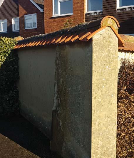
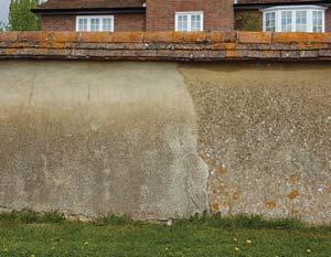


33 05. CHARACTER Variation of existing Wychert Walls across Haddenham 28


34 CHARACTER 5.4. Photographs of local town show fully boarded buildings, combinations of black weatherboarding with white/cream render and local brick Local Materials The proposed building fabric for the new development is a reflection of the materials found in the local town and in neighbouring sites. Proposing a range of locally distinctive materials will allow the new scheme to blend in naturally with its local surroundings. Black Weatherboarding One of the signature features on buildings in Haddenham is either fully or partly weatherboarded houses. These are often prominent buildings. On partly weatherboarded buildings the boarding is found on the gable, highlighting it as a main feature. There are a large number of black boarded buildings accompanied with a contrasting white render. Fully boarded buildings are often accompanied with a red pantiled roof. Brick There are several varieties of brick houses in Haddenham offering a range in colours and shades. Through some research it was noted that the most common shade is a traditional red brick. However, there are also multibricks and buff brick houses found throughout the town. In key areas, brick buildings are often paired with features of black feather edge boarding. Render There are two distinct shades of render found repeatedly in the local town. This includes a chalk white render and a cream/pearl render. Despite the difference in shade, these rendered buildings are often paired with black weatherboarding and red roof tiles. Rendered buildings with joining Wychert walls are often of the same shade. Tiles A varied mixture of roof tiles can be found in Haddenham. This includes red tiles, grey tiles and a variety of pantiles. It was discovered that a lot of the red tiles were accompanied with buildings with black weatherboarding as a main cladding material. 29


35 05. CHARACTER A black boarded house terminates the view of this proposed street, mirroring the existing black weatherboarded barn which terminates the view at the end on Church End Road, Haddenham The entrance from Aston Road features a prominent black weatherboarded house to mark the arrival into the proposed development 30


36 CHARACTER 5.7. Local architectural features found across the town in Haddenham Local Architectural Features To ensure that the design of the houses are suitable with their village setting and architectural context, research of the local architectural character has been undertaken. It took the form of an extensive tour of the local area, paying particular attention to defining architectural styles and detailing, elevation composition and distinctive materials. The above photographic summary illustrates the initial findings of this character style: A combination of red pantile roofs as well as grey roof tiles Cottage styled front doors Flat arched voussoir headers and traditional solider coursing Brick sill detailing Cottage styled crossbar windows Local brick buildings with exposed brick chimneys with simple detailing Full and partly feather-edged black weatherboarding occasionally paired with white rendered surfaces or brick Lean-to and gabled porches As shown on the opposite page, the selection of materials proposed for the development is a reflection of those found within Haddenham to ensure that the development responds positively to the local vernacular of the area. 31


37 05. CHARACTER 05 Plot 17: Character Features Full brick chimney, cross-bar windows, red pantiles roof, black weatherboarding Plot 70: Character Features Red tile roof, white render, partly weatherboarded, lean-to porch Plot 22: Character Features Rooftop chimney, cross-bar windows, brick cladding, voussoir lentils, brick sill, lean-to porch Plot 4: Character Features Rooftop chimney, cross-bar windows, red pantiles roof, half-boarded, brindle brick, gabled porch, cottage door Plots 181, 182, 183: Character Features Grey roof tiles, cross-bar windows, pearl render, black weatherboarding, gabled porch, cottage door 5.8. Local architectural features 32


38 CHARACTER 5.9. Character Area Plan The Central Green Connective Corridor Park View Village Edge The Lanes The Village Rural Edge Typical Character of Central Green The Central Green The Central Green represents the heart of the development, providing a generous open aspect as one enters off Stanbridge Road. The area provides a gateway through the site incorporating landscaping, public open space, a play area and vehicular, pedestrian and cycle routes. It will act as a main thoroughfare, creating a sense of community through movement, play and recreation. High quality dwellings will frame the space, providing a sense of ownership and passive surveillance to the Central Green and incorporating a traditional townscape vernacular comprising predominately red brick and a pearl render with weatherboarded accents, particularly to those buildings which frame key views through the space towards St Mary s Church. Typical Character of The Lanes The Lanes These residential areas have developed a strong sense of privacy within a more domestic setting off the principal vehicular routes. They will comprise intimate clusters of smaller sized homes along shared surface streets which encourage a sense of community and pedestrian and cycle priority. These areas take inspiration from the historic core of Haddenham where small collections of cottage-style dwellings share an access off the main street within a tranquil residential setting. These homes will comprise buff brick as the principal material alongside cottage style doors, porches and windows. The buff of the boundary of the site. 33


39 05. CHARACTER 05 Typical Character of Rural Edge Rural Edge These dwellings overlook the generous areas of public open space and the country park. They consist of family sized dwellings set within larger plots which are of a scale able to successfully frame such an expanse of open space. They have been designed to read as more visually imposing dwellings so that when viewed from within the open space, they give the perception of the type of properties which would have historically framed a central village square or would represent a historic village centre when viewed across farmland. The architecture at the edges of the site offer a modern interpretation of the local fabric comprising predominantly brindle brick and black weatherboarding as the prime materials. These family homes will include angled bay windows, chimneys, brick sills and voussoir headers. Typical character of the Connective Corridor Connective Corridor This part of the site has been designed to frame an important movement corridor as one travels north-south through the site. The properties comprise predominately smaller sized dwellings which create a strong collective street-scape along these routes in a manner that recognises the importance of the corridor but simultaneously seeks to reinforce the residential community that has been created. The overriding aim is to facilitate ease of movement through a part of the site which remains a coherent residential street and community. The palette of materials chosen will incorporate elements from all parts of the scheme in recognition of the connections that this space facilitates throughout the development. Typical character of The Village The Village The houses found on these quiet streets consist mainly of larger family homes set within an established residential context, similar to the historic heart of Haddenham. As one moves within the site from the more formal rural edge, there is an increasing sense of domesticity where traditional family homes create a sense of established community living within the heart of the development. These homes display a more varied vernacular including features such as white render accompanied with black weatherboarding and red roof tiles as the primary external building fabric. Houses will include angled bay windows, chimneys on key buildings and cross bar windows. Other key features in these areas Typical character of Village Edge Village Edge These areas adjoin the existing edge of Haddenham village and provide continuity between existing and future communities. The properties include a mixture of houses, bungalows and apartments, creating a varied street-scape which is representative of Haddenham as it has grown outward from its historic core over-time. The streets have a quiet, domestic character reinforced by shared surface treatments which encourage pedestrian and cycle movements and the creation of new neighbourhoods. Materials vary from pearl render and a local red brick with occasional black boarding to highlight feature buildings. Typical character of Park View Park View These dwellings overlook the large areas of public open space along the western section of the site. The houses here carry a varied mix between 2, 3 and 4 bed homes. Facing along this edge will minimise the visual impact of the new development. Homes on this road are on prominent locations on the Primary and Secondary road. Some houses will therefore be clad in black weatherboarding or include chimneys to address the roads as well as the public open space. 34
40 WORKING WITH THE SITE AND ITS CONTEXT 6.1. Outline Application Illustrative Master plan Key Frontages 6.2. Reserved Matters Application Proposed Site Layout 6 Working with the site and its context Does the scheme take advantage of the existing topography, landscape features (including water courses), trees and plants, wild life habitats, existing buildings, site orientation and micro-climate? Existing Site The Outline illustrative master plan was designed to both accommodate and respond to the existing topography whilst taking on the building grain that was shaped by the existing constraints and opportunities. The detailed proposal continues these principles by providing: The central green space that was identified in the Outline illustrative plan which is established as the heart of the development The main spine road that connects the main entrances has been maintained The same key frontages looking onto open space The sensitive rural edge to the south and west of the development remains as public open space The existing pedestrian links identified in the Outline master plan have been incorporated into the scheme and improved The proposed development is fitting to the site and its surroundings, and will make a positive contribution to the existing local character and within the wider context of Haddenham. The scheme will maximise the opportunities created by the existing site s topography, views, open spaces and the new links and connections formed. Minimal Visual Impact Special consideration has been given to the site s context, and every effort has been made to ensure that the scale and massing of the overall proposed scheme respects its rural location. The scheme therefore consists of low-rise residential homes respecting the surrounding urban grain and context. This will have a minimal visual impact allowing the new scheme to blend in with the existing village edge. 35
41 06. WORKING WITH THE SITE AND ITS CONTEXT Proposed Storey Heights Single Storey Two Storey Boundary and Site Edges The edges of the site are presented with key buildings carrying signature features. However, these buildings are not statement buildings or landmark buildings as this would detract from the project framework of blending in with the village approach to the development. These are instead versions of common house types, incorporating standalone features to achieve a sense of individuality and prominence. Sustainable Design The scheme has been designed with the key principles of sustainable development at the heart of the design process. A number of specific elements will be incorporated into the scheme from eliminating waste during the construction process through to benefiting the occupiers. The design of the proposed dwellings addresses energy efficiency to ensure conformity with policy and current Building Regulations including; high levels of thermal insulation to the external fabric; efficient heating systems; the use of low energy light fittings; use of energy efficient white goods; low water-use fittings to sanitary appliances; the use of PIR operated external light fittings; maximising the opportunity for waste recycling. Retaining Existing Landscape We have looked to retain and utilise the existing features of the site, namely the established hedgerow running east-west across the site. This will be reused as the boundary line fencing off the proposed burial ground. Landscape features provide character areas with dwellings facing onto the landscape and public open spaces. The layout has evolved to provide maximum permeability, defined character and enhanced landscaping to aid wayfinding through the scheme. Streets have been designed to create paths for both pedestrians, cyclists and vehicles to maximise permeability. 36
, trees and plants, wild life")
42 WORKING WITH THE SITE AND ITS CONTEXT 6.4. Landscape Strategy Plan 6 Working with the site and its context Does the scheme take advantage of the existing topography, landscape features (including water courses), trees and plants, wild life habitats, existing buildings, site orientation and micro-climate? Landscape Strategy Our vision for the site s landscape strategy has been driven by the site s natural features and the desire to enhance connections into the wider community. A network of green infrastructure will help create a legible, attractive and functional environment that supports a sense of community. Within this Green Infrastructure there are several important landscape spaces; Community Park, Country Park, Green Corridor and a Burial Ground. The Community Park is at the largest of the landscape spaces and provides essential play, recreation, sport and community space. Within this area, the Neighbourhood Equipped Area for Play (NEAP) will consist of a range of timber play equipment and be enveloped by earth mounding, tree planting and natural materials to create a sense of enclosure, encourage natural play and provide a secure stimulating play environment. Central to the park and framed by sculptural earth modelling, the cricket pitches have been provided to encourage community sports and promote an active healthy lifestyle. Proposed parkland tree planting and subtle sculptural land modelling has been incorporated into the open space to provide an undulating and sometimes playful environment. Along the south eastern boundary, the Country Park provides an informal character with an ecological focus. Naturally this area lends itself to the introduction of an attenuation basin for surface water, undulating landforms and swathes of wildflower meadow. A post and rail fence encloses the space to create a safe dog walking area. 37
43 NT_Bpub NS_Corave NS_Corave NS_Vibop NS_Vibop NT_Ag NT_Bpub NS_Corave NT_Ag NT_Bpub NT_Bpub 06. WORKING WITH THE SITE AND ITS CONTEXT The Green Corridor is set within the residential area Drainage Foul drainage will be via connections to the providing play, and passive recreation opportunities public foul sewers in Stanbridge Road, Aston Road and in the heart of the community. The Local Equipped located within the site boundary. Area for Play (LEAP) will be positioned within the Green Corridor and consist of a range of timber Due to the site topography it is not possible to connect play equipment and sculptural earth mounding to all new properties via a gravity network therefore encourage a sense of place through the atmosphere approximately 40No houses will be served by a foul created by play. Railings and self-closing gates pumping station located in the Amenity Land adjacent the securely contain the play area while allowing natural Aston Road boundary, which will in turn connect to the surveillance from adjacent housing. A swale, swathes public sewer in Aston Road. of wildflower meadow and community lawns surround the play area to help create a pleasant, gardenesque All foul sewer connections will be subject to consultation centre to the development with a human scale. with Thames Water to ensure the existing public sewer network has sufficient capacity to accommodate The Burial Ground reflects the seasonal cycle through the proposed flows with no detriment to other users planting and colour by incorporating memorial downstream of the development. meadows, woodland burial and a memorial garden. 06 The proposals seek to retain the existing public footpaths that run through and around the site, protecting the existing pedestrian links into Haddenham. In addition to these existing movement routes, several new pedestrian/ cycle connections are being created throughout the site, connecting up the green open spaces within the development to the existing connections beyond the boundary. The primary new connection point has been proposed to align with the pedestrian movement between the development and Haddenham St Mary s Church of England School and St Mary s Church to the west. Highways Access points for the residential development site are from Stanbridge Road and Aston Road and comprise a 6.75m wide carriageway m radius kerbs, sufficient to accommodate the proposed bus route. Other access points off Aston Road to serve the Burial Ground and Pumping Station comprise 5.5m carriageway + 6.0m radius kerbs. Visibility splays to each access point off Stanbridge Road and Aston Road are provided in accordance with 85th percentile measured vehicle speeds as given in the Transport Assessment undertaken by Transport Planning Associates (Sept 2014). The on-site road network will be to adoptable standard and derived in accordance with Manual for Streets 2 with 2.4m x 43.0m and 2.4m x 25.0m visibility splays/forward visibility envelopes suitable for 30mph and 20mph vehicle speeds respectively, where appropriate. The road network has been checked to ensure sufficient turning and manoeuvring for refuse vehicles (11.12m long) and fire tenders (7.70m long). In addition the main 6.75m wide bus route has been checked to ensure two buses can pass each other on the 90degree bend to the western side of the development. SUDS Surface water disposal will be via a combination of infiltration, via permeable road construction, and attenuated off-site discharge to the adjacent ditch network. The off-site discharge will be controlled to green field run-off rates, as agreed with the Lead Local Flood Authority (Buckinghamshire County Council), with storage provided on site via an open pond designed to accommodate storm events up to and including the 1in100year + 40% allowance for climate change. Open, shallow swales will be incorporated into the layout where possible to receive run-off from adjacent carriageways. The swales will have outfalls to the surface water drainage network NS_Co NS_ 6.5. Extract of Landscape Strategy Plan showing the proposed attenuation pond 38
44 CREATING WELL DEFINED STREETS AND SPACES 7.1. Plan showing the Constraints & Opportunities Gateway Buildings View terminating Buildings Key Buildings site. For instance, some have been designed to turn a 7 Creating well defined streets and spaces Are buildings designed and positioned with landscaping to define and enhance streets and spaces and are building designed to turn street corners well? corner and some carry added architectural elements that turns them into a key building. Using prime design features including full chimneys, weatherboarding and angled bay windows allows the key buildings to aid as way-finding through the scheme and provides points of reference along the internal routes. Enhanced Streets and Spaces The primary road has been defined by an open green space with informal planting. This provides a wider distance between dwellings along this route, clearly defining it as an informal primary space for all to use. A lower level of landscaping has been implemented on secondary streets, with grass, shrubs and bushes used to define the private and public realms. These areas are subservient to the central green space found along the primary route. Housing typology House types have been designed to perform specific roles depending where they sit on the As a principle there is no parking designed to be on the corner of a street, as this would create a weak edge with the car dominating the corner. Instead, we have used house types with dual aspects to turn the corner. These gateway houses (shown on Fig. 7.4) are successful in turning the corner due to the L shaped plan providing built form with bay windows to the side and a large window to the front of the plot. This extended side elevation provides mass to the corner plot. On most occasions, there will be a mirrored building that mimics the same material and architectural features. Paired, these will form a gateway which acts as a formal entrance to a new part of the site. 39


45 07. CREATING WELL DEFINED STREETS AND SPACES Streets on corners are designed to be turned well by addressing both frontages. Paired, these form a gateway access 7.3. The key building at the end of this road terminates the view and frames the space Gateway building: These buildings have a dual street aspect and have therefore been designed to address both sides using a side bay window. They further act as natural surveillance and ensures that public spaces are well over looked. Key buildings: These buildings have a more prominent presence and are often located in areas that will highlight them as a focal point. These aid the layout in terminating views and by acting as nodal points. 40

46 EASY TO FIND YOUR WAY AROUND 08.1 The Primary Road offers direct access to the Central Green space. This permeable area connects the north and south parts of the site. well as a key feature of the development. This large area 8 Easy to find your way around Is the development designed to make it easy to find your way around? further acts as a transition space between the northern and southern half of the site, making connections between and across the site visible and permeable. Secondary and tertiary streets provide maximum connectivity across the site. Secondary public spaces are predominantly soft landscaped and provide connections within the site Permeability The proposed layout has evolved to provide maximum permeability, defined character and enhanced landscaping to aid way-finding through the scheme. The large Central Green space situated at the heart of the scheme provides a civic space which integrates with the public open space connecting the site with the wider network. This central green area has been identified as a primary public space and acts as an arrival space as and to surrounding areas by a series of green links that are often reinforced by key buildings, features to corners and street ends to provide focal points and address the spaces. These spaces create a sense of place and strengthen the overall scheme. The public spaces proposed vary in size and character and form part of a comprehensive public realm strategy. Key spaces have been arranged throughout the proposed site plan to provide a variety of architectural and community focuses. 41


47 08. EASY TO FIND YOUR WAY AROUND The Central Green space allows for permeable connections and views, making it easy to identify your location 8.3.Street Scene extract: Key buildings and a varied mix in architectural style and methods aid in distinguishing different areas in the development 42


48 EASY TO FIND YOUR WAY AROUND Aerial View of Banks Road, Fort End and High Street View of Banks Road, Fort End and High Street Aerial View of The Paddocks View of The Paddocks Aerial View of Windmill Road View of Windmill Road Church End Aston Road The Paddocks Church End Aston Road All Images from section 8.5. Taken from Google Earth 8.5. Examples of the urban grain of the surrounding area in Haddenham 43


49 1. Informal Close. 2. Village Court 08. EASY TO FIND YOUR WAY AROUND 3. The Village Green. 08 The roads and footpaths within this enclosure are terminated with a terrace to create a sense of enclosure. The road leading up to this area reveals a wide open space at the end of it. This court has houses overlooking the area which also includes landscaping. This open space was not proposed in the Outline illustrative master plan, however, it was felt that it was essential to include this element in order to introduce another green space which will further act as an arrival space and nodal point Key plan highlighting areas where courts have been formed 8.7. Views of proposed court area with village green 8.8. View of proposed Village Green Urban Grain Analysis Following an extensive study of the local layout and building formation within Haddenham, it was discovered that there were several trigonal courts formed by the arrangement of street, roads and foot links. These spaces are often green and have houses overlooking the open space. The proposed site layout has drawn inspiration from the arrangement of buildings and roads found across the local area in order to create village court areas within the scheme. Way Finders The creation of these courts results in areas of unique identity. These open spaces will encourage a sense of community and a place of recognition, thus acting as pronounced way-finders around the development. Furthermore, these courts will mirror the existing local grain that surrounds the site, making it blend in with its wider urban context. 44
50
51 S T R E E T & H O M E
52 STREETS FOR ALL BCP 9.1. Extract of External Works Plan showing the changes in material on the streets and road surfaces because of the material changes creating a sense that the 9 Street for all Are streets designed in a way that encourage low vehicle speeds and allow them to function as social spaces? pedestrian has priority. This green space, once emphasis on vehicular movement is reduced, becomes a civic space. Connected to the existing landscape features and the pedestrian routes, the central green could be used for community events. Private drives are utilised to access small clusters of Vehicle Speeds and Social Spaces The proposed access roads will serve residential dwellings, comfortably accommodating the various vehicle types and anticipated manoeuvres. Within the proposed development the access road has been designed in order to encourage low vehicle speeds with appropriate traffic calming features such as changes in materials, bends, road narrowing and raised tables. On the Central Green, the difference in the soft and hard landscaping are detailed differently to the road to emphasise the transition. This space becomes a traffic calming measure homes. These streets have reduced widths to emphasise their private nature and reduce speeds across the shared surfaces. The proposed roads have been checked digitally for swept paths and forward visibility splays for refuse vehicles, service and fire vehicles. The overall movement network within the site will provide for all potential users, and maximise accessibility to all parts of the development. 47


53 09. STREETS FOR ALL Swept Path Analysis. Extract of proposed site plan indicating tracking for anticipated manoeuvres 48

54 CAR PARKING Parking Plan Garage Visitor Parking Spaces Assigned Parking Spaces visitor parking spaces. This standard in accordance with 10 Car parking Is resident and visitor parking sufficient and well integrated so that it does not dominate the street? the Neighbourhood plan and equates to the provision of 0.2 spaces per dwelling. Garages have not been counted towards the total count of car parking spaces and at no point are there more than two cars park spaces arranged in tandem. Car Parking An appropriate level of resident and visitor parking will be provided as part of the scheme, which will comfortably accommodate the expected requirement as stated in the Haddenham Neighbourhood Plan. For the overall development, there is sufficient parking spaces in accordance with the Neighbourhood Plan standards. The overall scheme will include a total of 56 unallocated Bicycle Parking The scheme complies with the Neighbourhood Plan guidance for cycling parking spaces. All houses have provided a space for two bicycles. These are to be stored in a proposed shed found in the rear gardens. As clear access between all rear gardens and public space are connected via their garden gates, all houses will have accessible, practical and safe cycling storage. This will promote and encourage the use of cycling as a means of transport. The apartment has a provision of 9 bicycles, one for each flat. These are stored in a joint storage facility. 49


55 10. CAR PARKING 10 Car parking spaces provided per dwelling On-plot/Allocated Parking Spaces Shared/ Unallocated Parking Spaces Cycle parking spaces provided per dwelling Individual Storage Communal Storage Not Applicable Table 2: Car and Cycle Parking The overall development complies with the Haddenham Neighbourhood Plan parking standards Street Scene extract: The majority of the houses have on plot parking, removing the need for overbearing parking courts 50


56 PUBLIC AND PRIVATE SPACES The diagrams show that areas not situated in the open space are well overlooked. Natural surveillance Existing foot - links Proposed foot - links cycle links. Within the site, more informal and visual open Public and Private Zones Public and private spaces will be clearly defined through the variety in material use and landscaping. In front of houses, low level landscaping will provide enclosure and a sense of private space. 11 Public and Private Spaces Will public and private spaces be clearly defined and designed to have appropriate access and be able to be well managed and safe in use? Defined parklands and open space have been provided within the scheme. This includes the linear tree line along the western part of the scheme which forms a formal entrance from Aston Road. This tree line leads up towards the play facilities, connecting to the zone at the north corner of the site. This park space also includes a cricket pitch and is intended for sports and recreational purposes. These spaces are easily accessible to all residents in the vicinity and are also connected via footpaths and spaces are provided. At the entrance of the southern entrance the space incorporates green parkland which leads up to the proposed attenuation pond. This area creates attractive views to the new residents and is primarily dedicated to dog walkers. The public open space through the centre of the site provides opportunities to create pedestrian links through the scheme connecting to the adjoining zones. To the south of the site the crescent of houses frame the southern view. Within this public open space an attenuation basin integrates with a strategic drainage system. Further to these public spaces all houses will have access to private amenity with gardens. These have been designed wherever possible to have a minimum of 20m back to back distances and 14m back to flanks. Natural Surveillance The development layout follow the principles of Secure by Design. All public open spaces are overlooked by active frontages offering natural surveillance. However, the scheme ensures that even narrow passages and pathways are overlooked by additional side windows on nearby houses. 51


57 11. PUBLIC AND PRIVATE SPACES The development on the southern edge frames the public open space at the south-western corner of the site. 52
58 EXTERNAL STORAGE AND AMENITY SPACE Refuse Strategy Plan Ownership Boundary 12 External Storage and amenity space Is there adequate external storage space for bins and recycling, as well as vehicle and cycles? First Reserved Matters Application Boundary Waste Storage Location in rear garden Waste Collection Location Pedestrian Route from Storage to Collection Crew distance to Bin Collection Point Refuse Strategy Provision for bin storage is in line with the councils refuse policy. Bins for all houses will be stored at the rear garden. Therefore each house has a gated access to the front of the property. This leaves the street frontages of all streets free of bins. In cases where a house is mid terrace, a short pathway to the rear is provided with a hard standing for bin collection from a designated place. Where relevant, the provision for bins is in line with adopted policy regarding drag distances. Vehicle turning head The apartment block has a designated bin store which includes provision for recycling. This bin storage complies with the councils refuse policy, providing the prescribed amount of bin capacity for the required amount of bin and recycling storage. 53
 Number of containers required for recycling 1 x 240 (mixed recycling) 1x 23 litre food caddy 1 x 240 litre wheeled bin (garden waste) 0-7 1 x 1100 litre bins 1 x")


59 12. EXTERNAL STORAGE AND AMENITY SPACE 12 Number of properties Individual houses Number of containers required for refuse 1 x 140 litre bin (where 5 or more people are resident 1 x 240 litre wheeled bin is supplied by application only) Number of containers required for recycling 1 x 240 (mixed recycling) 1x 23 litre food caddy 1 x 240 litre wheeled bin (garden waste) x 1100 litre bins 1 x 1100 litre bin x 1100 litre bins 2 x 1100 litre bins Container Dimensions (mm) Min floor space required(mm) 25 litre food waste bin Width x 420 Depth 400 Height litre wheeled bin Width x 570 Depth 558 Height litre wheeled bin Width 720 Depth 734 Height x x 1100 litre bins 3 x 1100 litre bins x 1100 litre bins per 21 4 x 1100 litre bins per 21 properties 360 litre wheeled bin (commercial waste only) 660 litre wheeled bin (commercial waste only) Width 760 Depth 880 Height 1100 Width 1000 Depth 800 Height x x litre Width 1375 wheeled bin Depth 1000 Height 1470 Height with lid open x Required bin capacity for the proposed development The required container dimensions for the bin provisions The proposed bin and bicycle storage for the Apartment block meets with the AVDC Recycling and Waste: Advice note for developers 2015 guidance All houses have external access to the rear garden to keep bins stored away from the street frontages, creating a clear street scape 54
60
61 S U M M A R Y
62 BUILDING FOR LIFE 12 SUMMARY 1 Connections Does the scheme integrate into its surroundings by reinforcing existing connections and creating new ones, while also respecting existing buildings and land uses around the development site? 2 Facilities and Services Does the development provide (or is it close to) community facilities, such as shops, schools, work places, parks, play areas, pubs or cafés? The proposal creates a development which integrates the new connections with the existing network links surrounding the site. Following the initial Outline application this scheme has ensured that all existing links and access points are preserved. The introduction of new access points, roads and footpaths will create accessibility and permeability to the new residents as well as existing ones. Haddenham offers several facilities and services including shops, schools and a medical centre. Facilities provided by the new development will include large open spaces, parks and landscaping, play areas, a cricket pitch, a pavilion and a burial ground. The new facilities are easily accessible and will be a positive addition to the wider community. 3 Public transport Does the scheme have good access to public transport to help to reduce car dependency? 4 Meeting local housing requirements Does the development have a mix of housing types and tenures that suit local requirements? The surrounding area of the site offers several existing services including local bus services train station. The location for the new development provides existing transport services such as buses, cycle routes and a train station. The project proposal looks to include further cycle routes as well as a new bus service which will go through the new development. The new bus service will encourage the use of public transport and benefit the new locals as well as the existing ones. The residential aspect of the scheme responds to the AVDC standards preferred mix of housing. This includes provisions for affordable houses and homes for the elderly. The affordable dwellings have been integrated well across the site with no excessively large clusters. The overall scheme has a varied mix of house types and sizes, all of which are tenure blind. 5 Character Does the scheme create a place with a locally inspired or otherwise distinctive character? 6 Working with the site and its context Does the scheme take advantage of the existing topography, landscape features (including water courses), trees and plants, wild life habitats, existing buildings, site orientation and micro-climate? Despite carrying its own identity, the proposed scheme has adopted the local style of the existing village. The distinct character areas have underpinned the rural identity of the local vernacular, and materials and architectural style mimicking those found within the local town. This includes incorporating Wychert Walls across the new development. Where possible the existing topography and landscape features are retained & enhanced with new green infrastructure and a new attenuation pond towards the sloping end of the site. The new dwellings will sit within a diverse range of new landscaped streets and public open spaces which will in-turn encourage social activities and community engagement. The proposed dwellings are a reflection of the existing village and are all below 2 storey in height. This means that the visual impact will be at a minimal. 57
63 BUILDING FOR LIFE 12 SUMMARY 7 Creating well defined streets and spaces Are buildings designed and positioned with landscaping to define and enhance streets and spaces and are building designed to turn street corners well? 8 Easy to find your way around Is the development designed to make it easy to find your way around? There are a series of attractive streets and spaces with a clear hierarchy of roads, footpaths, private drives and shared surface roads. Pedestrian routes are well defined linking onto all public open spaces. Houses have been designed to address streets through their materials and architectural features. This includes gateway buildings which successfully turns corners by addressing both sides of the street. The proposed development is both pedestrian and bicycle friendly. It has deliberately been designed to make it easy to move around. The Central Green found at the heart of the site acts as a reference point along the primary route. Due to its large site, the Central Green is easily accessible and quick to locate. Distinct characters such as key buildings and courts have been articulated to be more distinct in design. This allows them to aid in movement around the site by acting as way-finders. 9 Street for all Are streets designed in a way that encourage low vehicle speeds and allow them to function as social spaces? 10 Car parking Is resident and visitor parking sufficient and well integrated so that it does not dominate the street? The proposed roads follow a hierarchy and pattern that are pedestrian friendly. These are designed to encourage vehicles to drive slowly and carefully using traffic calming measures including bends on the roads, change of materials, narrowing of roads and raised tables where appropriate. The streets and public open spaces are designed with Manual for Streets guidance in mind to increase the potential of social activity. Parking where possible is on plot and in accordance with policy found in Haddenham Neighbourhood Plan Spaces in the count does not include garages. Using on plot parking avoids an overbearing impact on the streetscape. Visitor parking spaces have been provided throughout the scheme, providing 0.2 spaces per house which is in accordance with the local policy. Bicycle storage is provided for all dwellings as per the required amount stated in the Haddenham Neighbourhood Plan Public and Private Spaces Will public and private spaces be clearly defined and designed to have appropriate access and be able to be well managed and safe in use? 12 External Storage and amenity space Is there adequate external storage space for bins and recycling, as well as vehicle and cycles? Spaces throughout the scheme have been well defined to establish Public and Private spaces. This has been achieved in a variety of ways including a change in the material language on roads and landscaping. Secured By Design principles have been used to create a safe neighbourhood by maximising permeability and by ensuring that all areas within the proposed design are well overlooked. Secure and sufficient storage space will be provided for bins. This will carefully be integrated into the typologies predominantly within private back gardens. This includes all proposed houses as they have been designed to provide access to the rear garden. This reduced the visual impact the bins will have on the streetscape. The apartment block has a shared bin storage and collection point. All bin storage spaces are designed in accordance with AVDC s Recycling and Waste Advice Notes for Developers 2015 guidance document. 58
64 DESIGN CONCEPT SUMMARY DISTINCTION: The design proposal has created a clear distinguished space that has its own identity. Throughout the scheme there are areas of interest, attractive and successful outdoor spaces which provide facilities for the wider community. CONNECTIONS: The site is easily accessible and the proposed connections around the new development are made to be clear and easy to move around the scheme. Newly proposed footpaths, cycle routes and bus services will encourage the use more public transport. RESPONSIVE: The scheme has been moulded by its existing constraints and opportunities. It has naturally evolved by using and developing existing character features including its open spaces, views and landscape features. REFLECTION: Haddenham. Features including architectural character, local grain have all been adopted to create a development that sits well along its vicinity. 59


65 DESIGN CONCEPT SUMMARY A varied mix of house types have been designed and articulated using a palette of architectural materials, styles and textures prevalent with its local area. The overall design proposal provides a safe and community led neighbourhood that sits well in its landscape surrounding. The new development offers open spaces, play areas and transport services. Through the development of new access points and connections the scheme encourages integration with the wider context of Haddenham, contributing these facilities for all. This development has been designed to give a sense of place and with the intention of making the new residents feel a sense of belonging, ownership and delight. 60
Public Consultation. Land at Monks Farm, North Grove. Welcome
 Welcome Welcome to our public exhibition for development on Land at Monks Farm, orth Grove. Gallagher Estates and Gleeson Strategic Land are preparing an outline planning application for new homes, open
DESIGN & ACCESS STATEMENT
 DESIGN & ACCESS STATEMENT January 2016 Contents Introduction section 1 Section 1 - Introduction Section 2 - Assessment Section 3 - Involvement Section 4 - Evaluation Section 5 - Design Section 6 - Layout
PHASE III: Reserved Matters Submission
 Statement of Compliance with the outline approval for the proposed residential development of land at: BURGES LANE, WIVELISCOMBE PHASE III: Reserved Matters Submission Foreword Contents: This Statement
Chapter 2: OUTLINE PLANNING APPLICATION PROPOSALS. A New Garden Neighbourhood Matford Barton 17
 Chapter 2: OUTLINE PLANNING APPLICATION PROPOSALS A New Garden Neighbourhood Matford Barton 17 2.1. SUMMARY AND STATUS OF THE PROPOSALS 2.1.1. The parameter plans and associated wording in this chapter
CALA HO ME S WELCOME
 WELCOME Welcome to this public consultation event for our proposed residential development of 56 high quality homes on land to the north east of Station Road in Earls Colne. Thank you for taking the time
PDP DESIGN & ACCESS STATEMENT
 PDP The Planning & Design Partnership Planning.. Architecture.. Interiors.. Landscape The Chicory Barn Studio, The Old Brickyards, Moor Lane, Stamford Bridge York, The East Riding Of Yorkshire, YO41 1HU.
INTRODUCTION. Land south of Bishopswood Lane, Tadley
 0 INTRODUCTION THE SITE Introduction Gladman Developments Ltd. has successfully invested in communities throughout the UK over the past 0 years, developing high quality and sustainable residential, commercial
WELCOME. Land North of STEVENAGE. We would like to thank you for attending our public exhibition today.
 WELCOME We would like to thank you for attending our public exhibition today. The purpose of this event is to share our proposals and hear your thoughts on our ideas. Members of the project team are on
Colchester Northern Gateway Master Plan Vision Review Draft. July 2016
 Colchester Northern Gateway Master Plan Vision Review Draft July 2016 Contents Introduction 4 Context 8 Purpose of the Report 8 Strategic Position 9 Overview of the Process 11 2012 Master Plan Vision 12
Welcome to our public exhibition
 About our development Welcome to our public exhibition This exhibition gives you the chance to view and comment on our proposals for a new residential development of 165 high-quality homes, along with
8.0 Design and Form of Development 43/
 42/ 8.0 Design and Form of Development 43/ Rothwells Farm, Golborne/ Development Statement Figure 7. Site Constraints Key 44/ Site Boundary 360 Bus Route/Stops Existing Trees Underground Water Pipe Sensitive
DESIGN & ACCESS STATEMENT
 DESIGN & ACCESS STATEMENT Land to the South East of the A495, Bronington Erection of 31 Dwellings (27 dwellings and 4 bungalows including 4 Affordable Dwellings), Realignment and Improvements to A495 (including
Kibworth Harcourt. Introduction. Introduction
 Introduction Introduction Welcome to this public exhibition on the proposals for the delivery of new homes on land at The Kibworths. The purpose of today s exhibition is to give you the opportunity to
Welcome. Land adjacent Sandy Lane WALTHAM CHASE THE PROPOSED SITE
 Land adjacent Sandy Lane WALTHAM CHASE Existing Linden Homes developments Welcome Welcome to Linden Homes Southern s ( Linden ) public exhibition about its proposals for a range of high-quality homes for
DESIGN & ACCESS STATEMENT. REVISION A Residential Development, Neon Social Club, Nairn Street, Jarrow.
 DESIGN & ACCESS STATEMENT. REVISION A Residential Development, Neon Social Club, Nairn Street, Jarrow. The following Design & Access Statement is in support of a Full Planning Application for a residential
HARDWICK GREEN, King s Lynn. Welcome to our Exhibition. What are your views? Introduction to the site and proposals. About us
 HARDWICK GREE, King s Lynn Welcome to our Exhibition Welcome to our exhibition, which is being held to provide you with the opportunity to understand and comment upon our proposals for new residential
Welcome to our public exhibition
 About Our Scheme Welcome to our public exhibition This exhibition gives you the chance to view and comment upon our emerging proposals for a new residential development of 68 new homes on the site of the
Statement of Community Involvement LAND OFF SOUTHDOWN ROAD HORNDEAN, HAMPSHIRE
 LAND OFF SOUTHDOWN ROAD HORNDEAN, HAMPSHIRE CONTENTS Page 1. Introduction 3 2. Pre-application Discussions 4 3. The Consultation Process 5 4. Consultation Feedback 7 5. Responses to Consultation Feedback
Welcome to our public exhibition
 About our scheme Welcome to our public exhibition Taylor Wimpey East Anglia intends to submit a detailed planning application for a new residential development of 39 high-quality homes at the B&M Concrete
Schedule of Planning Applications Committee Date: 23 May Reference: 06/17/0726/F Parish: Hemsby Officer: Mr J Beck Expiry Date:
 Schedule of Planning Applications Committee Date: 23 May 2018 Reference: 06/17/0726/F Parish: Hemsby Officer: Mr J Beck Expiry Date: 22-05-2018 Applicant: Proposal: Site: Mr Gillett Change of use to the
Story Homes. Land at Thirsk Road, Kirklevington. An Introduction to Story Homes. Our Foundations. Commitment to Consultation.
 Story Homes An Introduction to Story Homes Founded by Fred Story in 1987, Story Homes has a long and successful reputation of building high quality and high specification homes. The family owned business
CALA Homes is preparing a planning application for a development of up to 36 new homes, including a mix of properties to meet local demand.
 WELCOME Welcome to this public consultation event for our proposed development on land to the south of Twelve Leys in Wingrave. Thank you for taking the time to come along today. Homes is preparing a planning
WELCOME GYPSY LANE. Wider Site Location plan. Proposals for the development of LAND OFF FOXLYDIATE LANE WEBHEATH. Proposals for the development of
 WELCOME The developers are preparing an outline planning application for a residential led development and need the community s views in order to develop the proposals further WHAT IS PROPOSED? A high
vision & process willowburn, tarves community engagement 04/18
 vision & process Historic Conservation area Scotia intend to create a high quality residential development based upon best practice urban design principles. This will include a contemporary reinterpretation
LONGDEN VILLAGE DEVELOPMENT STATEMENT
 LONGDEN VILLAGE DEVELOPMENT STATEMENT 2017-2027 1 Longden Development Statement 2017-2027 15/01/18 1. Background 1.1 Longden Village Longden village is a very rural and traditional community first mentioned
97 Lea Bridge Road, Leyton, E10 7QL London Borough of Waltham Forest December 2015
 97 Lea Bridge Road, Leyton, E10 7QL London Borough of Waltham Forest December 2015 Public Realm and Landscape Proposals LEA BRIDGE ROAD, WALTHAMSTOW Public Realm & Landscape Proposals BDP(90)RPT001 December
WELCOME TO THE NEW WILTON PARK
 WELCOME TO THE NEW WILTON PARK VISION HISTORY OF WILTON PARK TOWARDS A PLANNING APPLICATION Our objective is to create a truly outstanding environment at Wilton Park. At the heart of our proposals is a
Derry City and Strabane District Council Planning Committee Report
 Derry City and Strabane District Council Planning Committee Report COMMITTEE DATE: 23 rd March 2016 APPLICATION No: APPLICATION TYPE: PROPOSAL: LOCATION: APPLICANT: LA11/2015/0395/F Residential Development
Warren Farm, Ampthill
 1 Welcome The developers of the Warren Farm site, Bloor Homes and Connolly Homes, are holding this exhibition on the emerging Design Codes for the development prior to their formal submission to Central
Introduction. Welcome to this consultation regarding the draft redevelopment proposals for the former CeramTec factory on Sidmouth Road, Colyton.
 Introduction Welcome to this consultation regarding the draft redevelopment proposals for the former CeramTec factory on Sidmouth Road, Colyton. We are currently considering options for the mixed-use redevelopment
Housing Development at Balloonagh Tralee Co Kerry
 Design Statement Housing Development at Balloonagh Tralee Co Kerry Area of site 10,400m2 24 houses-12no 3 bed, 12no 2 bed and 4 single bed apartments total residential area of 2411m2 Open space provided
MATURE SUBURBS RESIDENTIAL DEVELOPMENT GUIDELINES
 MATURE SUBURBS RESIDENTIAL DEVELOPMENT GUIDELINES DRAFT FEBRUARY 2005 BIRMINGHAM CITY COUNCIL 1 Introduction Mature Suburbs Residential Development Guidelines - Interim Supplementary Planning Advice -
BLETCHLEY PARK AREA - DEVELOPMENT FRAMEWORK
 ANNEX A To Item 9 REVISED TEXT: additions shown bold and underlined, deletions in (brackets and in italics). BLETCHLEY PARK AREA - DEVELOPMENT FRAMEWORK This framework sets out the key objectives and requirements
ABOUT CALA HOMES CALA HOMES
 WELCOME Welcome to this public consultation event for our proposed development on land to the east of Salisbury Road, in Hungerford. Thank you for taking the time to come along today. Homes and Wates Developments
Neighbourhood Planning Site Assessment Pro-forma and Guide Version 2
 Neighbourhood Planning Site Assessment Pro-forma and Guide Version 2 September 2014 Site HNP 006 Land East of Stanbridge Road and North of Lower Road 1. Background information Site location and use Site
Carterton Construction Ltd is bringing forward plans for up to 85 new family homes and extra care facilities on land east of Burford.
 Welcome Carterton Construction Ltd is bringing forward plans for up to 85 new family homes and extra care facilities on land east of. We are at the early stages of designing our proposals and have a number
Neighbourhood Planning Local Green Spaces
 Neighbourhood Planning Local Green Spaces Introduction... 2 1. Why green space is important... 4 2. Neighbourhood plans and green space... 6 3. Evidence... 8 Statutory designations... 9 Green space audit...
STATEMENT OF OBJECTION TO THE PROPOSED DEVELOPMENT OF LAND AT CHURCH CLIFF DRIVE FILEY
 STATEMENT OF OBJECTION TO THE PROPOSED DEVELOPMENT OF LAND AT CHURCH CLIFF DRIVE FILEY You will be aware that Scarborough borough council have adopted a new local plan that includes land at Church Cliff
Newcourt Masterplan. November Exeter Local Development Framework
 Newcourt Masterplan November 2010 Exeter Local Development Framework Background The Exeter Core Strategy Proposed Submission sets out the vision, objectives and strategy for the development of Exeter up
Welcome to our exhibition
 Welcome to our exhibition The Homes & Communities Agency (HCA) welcomes you to this public exhibition explaining our proposals for the redevelopment of the former Lea Castle Hospital site. About the Homes
PROPOSED RESIDENTIAL DEVELOPMENT LAND AT TRETHURFFE LADOCK, TRURO Design & Access Statement
 PROPOSED RESIDENTIAL DEVELOPMENT LAND AT TRETHURFFE LADOCK, TRURO Design & Access Statement Heron Way, Newham, Truro, Cornwall, TR1 2XN Tel: 08453 707 111 Fax: 08453 707 113 www.csa-architects.co.uk E:
Welcome. Site/11/04. Site/11/03. Proposed Site. 11,400 new homes needed in east Cambs
 Welcome Welcome to our consultation on our proposals for new homes on land north east of Soham Road, Fordham. Members of the project team are available to answer any questions you have and listen to feedback.
1. Local Plan Context
 1. Local Plan Context WHY ARE YOU HERE? ABOUT US PLANNING APPLICATION CONSULTATION Stewart Milne Homes are in the process of preparing a detailed planning application for a development of approximately
New-Cast Mixed-use Development Proposal King Street West, Newcastle, Ontario
 URBAN DESIGN BRIEF New-Cast Mixed-use Development Proposal King Street West, Newcastle, Ontario TABLE OF CONTENTS: 1.0 Executive Summary 2.0 Creating Vibrant and Sustainable Urban Places: Excerpts from
Subdivision Design Criteria. Penihana North GUIDELINES TO THE RULES
 Created September 2013 Penihana North Subdivision Design Criteria GUIDELINES TO THE RULES This part of the Plan sets out the design criteria for subdivision in Penihana North. The criteria will be considered
Welcome. Proposals for land at Smug Oak Lane BRICKET WOOD
 Proposals for land at Smug Oak Lane BRICKET WOOD Previous Linden Homes and Wates Developments scheme Welcome Welcome to Linden Homes and Wates Developments public exhibition. Working together as joint
CAERNARFON DEPENDENCY CATCHMENT AREA
 CAERNARFON DEPENDENCY CATCHMENT AREA GWYNEDD UNITARY DEVELOPMENT PLAN - HOUSING Map not to scale Dependency Catchment Area Location 2 Caernarfon Topic Housing To the rear of Bro Eglwys, Bethel. Grid Ref.
Urban Design Guidelines
 Urban Design Guidelines These Urban Design Guidelines comprise the Key Design Objectives below, the Roads Design Guidelines overleaf and Neighbourhood Framework Plans. Together with Section 3: Urban Design
Persimmon Homes Thames Valley Date received: 2 nd April week date(major): 2 nd July 2014 Ward: Nascot
: 2 nd July 2014 Ward: Nascot") PART A Report of: DEVELOPMENT MANAGEMENT SECTION HEAD Date of Committee: 26 th June 2014 Site address: Rounton, 28, Nascot Wood Road Reference Number: 14/00497/REM Description of Development: Reserved
PART A Report of: DEVELOPMENT MANAGEMENT SECTION HEAD Date of Committee: 26 th June 2014 Site address: Rounton, 28, Nascot Wood Road Reference Number: 14/00497/REM Description of Development: Reserved
2.0 Strategic Context 4
 2.0 Strategic Context 4 2.1 The Area Action Plan is a non-statutory plan, which forms a corporate policy document, expressing particular issues and areas of concern while also providing a vision for the
BLACKHEATH SQUASH CLUB Blackheath Sports Club, Rectory Field, Charlton Road, London, SE7 7EY. Planning, Design and Access Statement
 Planning, Design and Access Statement Revised: 28 th Jan 2016 Peter Pendleton & Associates Ltd Introduction Planning permission will be sought for a refurbishment of existing courts and extension to provide
Nelson Residential Street Frontage Guideline
 DRAFT 22-06-2012 Nelson Residential Street Frontage Guideline June 2012 1317273 Contents and purpose Residential s are important Residential s are much more than corridors which move traffic. Streets allow
4.0 URBAN DESIGN FRAMEWORK. The vision for the future development of the plan area is to:
 4.0 The vision for the future development of the plan area is to: Create a new neighbourhood that focuses on the highly valued natural and aesthetic features of the lands and provides good quality homes,
Alder View. Introduction. Alder View. Harwell. The Vision. The Team. Taylor Wimpey
 Introduction Welcome to the public exhibition for, a development by Taylor Wimpey on the land south of Grove Road,. This exhibition will provide an overview of the development proposals for the site and
10 Proposed Redevelopment, Tewkesbury Road, Cheltenham SCHEME EVOLUTION STARBUCKS
 SCHEME EVOLUTION STARBUCKS The proposed Starbucks Drive Thru alongside the proposed food store provides an appropriate mix of uses, suitable for this location. The proposed store is bespoke, designed specifically
INTRODUCTION NORTH HEYBRIDGE GARDEN SUBURB
 INTRODUCTION This event is being hosted by the promoters of the proposed North Heybridge Garden Suburb who are working with Maldon District Council and other key stakeholders on the preparation of a comprehensive
Carton Avenue Action Area Plan Maynooth
 Carton Avenue Action Area Plan Maynooth Kildare County Council JULY 2006 (AAP) Table of Contents Section 1. Introduction...3 Statement of Strategy...3 Location of the Lands...3 Context in the Town Development
3.1 The hybrid planning application proposes the following description of development:
 CHAPTER 3: PROPOSED DEVELOPMENT 3.1 The hybrid planning application proposes the following description of development: Hybrid (part-outline/part-full) planning application for a single composite development
PLANNING COMMITTEE. 14 October 2014
 AGENDA ITEM NO 8 PLANNING COMMITTEE 14 October 2014 APPLICATION NUMBER : CA//14/01744/FUL PROPOSAL : Extension and conversion of roof space of an existing detached bungalow together with enhanced parking
Page 1 of 19 URBAN DESIGN FRAMEWORK FOR BOLTON STREET WATERFORD
 Page 1 of 19 URBAN DESIGN FRAMEWORK FOR BOLTON STREET WATERFORD 1.0 Introduction: The relocation of the City Council stores and depot from Bolton Street creates an exciting opportunity for development
Section Three, Appendix 17C Multiple Unit Housing Design Assessment Criteria
 APPENDIX 17C MULTIPLE UNIT HOUSING DESIGN ASSESSMENT CRITERIA Purpose of Appendix 17C In the Residential 9 Zone the construction and use of multiple household units located within the Multiple Household
DESIGN AND ACCESS STATEMENT Reserved Matters Application
 DESIGN AND ACCESS STATEMENT Reserved Matters Application Submitted to: Newcastle Under Lyme Borough Council Prepared by: Nicol Thomas Architects On behalf of: Kier Living Proposed Residential Development
Land Adj. 63 Sunny Bank Road, Sutton Coldfield, Birmingham, B73 5RJ
 Committee Date: 11/07/2013 Application Number: 2013/03520/PA Accepted: 20/05/2013 Application Type: Full Planning Target Date: 15/07/2013 Ward: Sutton Vesey Land Adj. 63 Sunny Bank Road, Sutton Coldfield,
CENTRAL BEDFORDSHIRE COMMITTED TO WORKING TOGETHER WITH LOCAL COMMUNITIES
 WELCOME Thank you for coming to our consultation event to find out more about our emerging proposals for Hayfield Park, a residential development jointly promoted by the Hayfield Consortium: Martin Grant
Derry City and Strabane District Council Planning Committee Report. Amended layout from approval A/2004/0462/F with reduction from 166 units
 Derry City and Strabane District Council Planning Committee Report COMMITTEE DATE: 1 st February 2017 APPLICATION No: APPLICATION TYPE: PROPOSAL: LOCATION: APPLICANT: AGENT: Full Planning application Amended
Introduction to MP3. MP3 H4 Park Central (North)
") MP H4 Park Central (North) Introduction to MP A visualisation of the Illustrative Masterplan with MP shaded in blue MP is the third phase of the Elephant Park regeneration and is bounded by on the north,
MP H4 Park Central (North) Introduction to MP A visualisation of the Illustrative Masterplan with MP shaded in blue MP is the third phase of the Elephant Park regeneration and is bounded by on the north,
DESIGN & ACCESS STATEMENT
 . DESIGN & ACCESS STATEMENT Site Adjacent to The Manor House, Upper Street,, Kingsdown, Deal, Kent. DESIGNS ARCHITECTURE + PLANNING CONTENTS Design and Access Statement Introduction Site and Location Planning
Section Three, Appendix 16C Medium Density Housing, Design Assessment Criteria (Residential 8A zone)
") APPENDIX 16C MEDIUM DENSITY HOUSING, DESIGN ASSESSMENT CRITERIA (RESIDENTIAL 8A ZONE) PURPOSE OF APPENDIX 16C (RESIDENTIAL 8A ZONE) In the Residential 8A Zone the following are defined as restricted discretionary
APPENDIX 16C MEDIUM DENSITY HOUSING, DESIGN ASSESSMENT CRITERIA (RESIDENTIAL 8A ZONE) PURPOSE OF APPENDIX 16C (RESIDENTIAL 8A ZONE) In the Residential 8A Zone the following are defined as restricted discretionary
FORMER CANADIAN FORCES BASE (CFB) ROCKCLIFFE SECONDARY PLAN. Official Plan Amendment XX to the Official Plan for the City of Ottawa
 ROCKCLIFFE SECONDARY PLAN. Official Plan Amendment XX to the Official Plan for the City of Ottawa") FORMER CANADIAN FORCES BASE (CFB) ROCKCLIFFE SECONDARY PLAN Official Plan Amendment XX to the Official Plan for the City of Ottawa 1 INDEX THE STATEMENT OF COMPONENTS PART A THE PREAMBLE PAGE Purpose...
FORMER CANADIAN FORCES BASE (CFB) ROCKCLIFFE SECONDARY PLAN Official Plan Amendment XX to the Official Plan for the City of Ottawa 1 INDEX THE STATEMENT OF COMPONENTS PART A THE PREAMBLE PAGE Purpose...
design & access statement Proposed Erection of 68 Bedroom Hotel and Restaurant with Associated Landscaping
 Proposed Erection of 68 Bedroom Hotel and Restaurant with Associated Landscaping Promenade, design & access statement lawrencemcphersonassociates 6 new road, ayr, ka8 8ex On Behalf of July 2015 CONTENTS
Application Recommended for Approval Hapton with Park Ward
 Application Recommended for Approval Hapton with Park Ward APP/2017/0036 Outline Planning Application Outline application for the construction of a new 3 bedroom dwelling (with all matters reserved for
CA//16/00504/FUL. Canterbury City Council Military Road Canterbury Kent CT1 1YW. Crown copyright and database rights 2016 Ordnance Survey
 O Scale 1:1,250 Map Dated: 09/05/2016 CA//16/00504/FUL Crown copyright and database rights 2016 Ordnance Survey 100019614 Canterbury City Council Military Road Canterbury Kent CT1 1YW AGENDA ITEM NO 13
Site north of Hattersley Road West (east of Fields Farm Road), Hattersley
, Hattersley") Application Number 17/00982/REM Proposal Site Applicant Recommendation Reason for report Application for the approval of reserved matters (means of access, landscaping, layout, scale and appearance) relating
Application Number 17/00982/REM Proposal Site Applicant Recommendation Reason for report Application for the approval of reserved matters (means of access, landscaping, layout, scale and appearance) relating
WHITELEY TOWN COUNCIL NORTH WHITELEY DEVELOPMENT SEPTEMBER 2014
 WHITELEY TOWN COUNCIL NORTH WHITELEY DEVELOPMENT SEPTEMBER 2014 Dear Resident This Special Edition of the Whiteley Voice which has been prepared in conjunction with the North Whiteley Consortium is to
Former Temple Cowley Pools, Oxford TEMPLE COWLEY LIBRARY * ELEVATION SHOWN IS INDICATIVE AND SUBJECT TO FINAL DESIGN AND AGREEMENT.
 OPEN SPACE TEMPLE COWLEY LIBRARY library beyond Proposed apartments Proposed apartments Proposed houses Temple Road * ELEVATION SHOWN IS INDICATIVE AND SUBJECT TO FINAL DESIGN AND AGREEMENT. * Welcome
GREENFORD HALL & ADJOINING LAND
 GREENFORD HALL & ADJOINING LAND CONTENTS 1. Introduction 1. Introduction 2. Urban Context 2.1 The Site and Surroundings 2.2 Urban Context Map 2.3 Access and Movement 3. Planning Context 3.1 Planning History
OKEFORD FITZPAINE NEIGHBOURHOOD PLAN
 OKEFORD FITZPAINE NEIGHBOURHOOD PLAN Dear Parishioner, The Neighbourhood Plan Project Team have prepared this leaflet to summarise the full Neighbourhood Plan document. It provides a summary of the Vision,
Section 4 - Public Realm & Landscape proposals Landscape Masterplan. Section 4 52
 - Public Realm & Landscape proposals Landscape Masterplan 52 Proposed Masterplan - Green Infrastructure Strategy District Park 4.33 Ha to provide Passive and active recreation with a large play area which
Welcome to our Public Consultation
 About our development This exhibition gives you the chance to view and comment on our emerging plans for a proposed residential development located on land to the West of Alwyn Road, Rugby. Welcome to
Welcome to our public exhibition
 About our development Welcome to our public exhibition This public exhibition gives you the opportunity to view and comment on our proposals to create a new residential development on land adjacent to
Chapter 13 Residential Areas: Appendices APPENDIX 1 Residential Areas
 Chapter 13 Residential Areas: Appendices Page 1 Chapter 13 Residential Areas: Appendices APPENDIX 1 Residential Areas Design Code for Intensive Housing INTRODUCTION DESIGN ELEMENTS A NEIGHBOURHOOD DESIGN
edge of gas line corridor setback edge of gas line corridor aligned with Schlumberger building 37.0 m AOD 33.0 m AOD max
 7. Heights and Street Frontage: In accordance with the approved heights parameters, heights to along Western Access Road must respond to the existing low density character in this location. Heights are
Design Guidance. Introduction, Approach and Design Principles. Mauritius. November Ministry of Housing and Lands. .. a
 sig evelo r D Mauritius s. Utilities.. Individu a s. er itects.to ls chpers.po e Public. T. h rban D Sc U e me Promot e h ners. A Design Guidance o.h Planne rs n w iticians r l useholde National Development
PLANNING STATEMENT. Market House Market Place Kingston upon Thames KT1 1JS
 PLANNING STATEMENT To support planning and listed building consent applications for change of use from Class A1 shop and Class A3 cafe to Class A3 restaurant at: Market House Market Place Kingston upon
Chapter 5 Urban Design and Public Realm
 5.1 Introduction Public realm is all areas of the urban fabric to which the public have access. It is where physical interaction takes place between people. It therefore, includes buildings and their design,
Woodbrook - Shanganagh
 Section 4: Key Sites Framework Strategy Woodbrook - Shanganagh Local Area Plan 2017-2023 4. Site Framework Strategies The Master Plans shall have regard to the thematic objectives under the LAP Development
Land off Arbour Close and Cotswold Edge Mickleton, Gloucestershire. Design and Access Statement Mickleton, Gloucestershire
 Land off Arbour Close and Cotswold Edge Contents INTRODUCTION Vision SITE DESCRIPTION The site Technical Assessment ASSESSMENT & EVALUATION Constraints and opportunities SITE CONTEXT Pattern of Development
ILLUSTRATIVE MASTERPLAN
 ILLUSTRATIVE MASTERPLAN The Development Dairy Crest (Imperial College) The Proposed Development aims to create a new high quality residential neighbourhood, alongside a new public park for White City.
4. MASTERPLAN FRAMEWORK
 6a 6b 4. MASTERPLAN FRAMEWORK 6. Car Parks 6c Car Parks 6a and 6b will provide permanent parking. Area 6a will serve the foodstore with tarmac surfacing within a defined area to the west of the adjacent
WELCOME. North East Haverhill. The Planning Process
 WELCOME North East The site to the North East of, known as Great Wilsey Park, is identified by St Edmundsbury Borough Council in its Core Strategy as capable of delivering a Sustainable Urban Extension.
Potten End C of E First School Proposed Expansion to One Form Entry Primary Planning Consultation Presentation
 01 05 06 01 02 06 EXISTING SITE The school is located in an attractive village with predominately two storey pitched roofed houses, gardens and open common land. The existing school building is more modern
WELCOME. Olney Road, Lavendon INTRODUCTION. The Site. The Application. The Need for Housing. A Sustainable Location LAVENDON TURVEY OLNEY ROAD
 0 WELCOME INTRODUCTION Gladman Developments Ltd have successfully invested in communities throughout the UK over the past 0 years, developing high quality and sustainable residential, commercial and industrial
SOUTH CAMBRIDGESHIRE DISTRICT COUNCIL. Executive Director (Operational Services) Corporate Manager (Planning and New Communities)
 Corporate Manager (Planning and New Communities)") SOUTH CAMBRIDGESHIRE DISTRICT COUNCIL REPORT TO: Planning Committee 12 January 2011 AUTHOR/S: Executive Director (Operational Services) Corporate Manager (Planning and New Communities) Notes: S/1848/10
SOUTH CAMBRIDGESHIRE DISTRICT COUNCIL REPORT TO: Planning Committee 12 January 2011 AUTHOR/S: Executive Director (Operational Services) Corporate Manager (Planning and New Communities) Notes: S/1848/10
Reserved Matters application for a site that straddles the boundary between CBC and BBC
 BBC APPLICATION 15/02682/MAR NUMBER CBC APPLICATION CB/15/04294/RM NUMBER LOCATION Wixams Land at former storage depot, Bedford Road, Wilstead Bedfordshire PROPOSAL Reserved Matters Application for Strategic
DESIGN & ACCESS STATEMENT
 DESIGN & ACCESS STATEMENT Demolition of Detached Dwellinghouse and Construction of 11 Dwellinghouses with Access Road & Associated Infrastructure, Ystradgynlais, Powys On Behalf of Watree Homes Limited
Urban Design Brief Proposed Residential Development 5219 Upper Middle Road City of Burlington
 Urban Design Brief Proposed Residential Development 5219 Upper Middle Road City of Burlington Prepared by Weston Consulting Prepared for BLOOMFIELD DEVELOPMENT INC. Date: March 2017 Table of Contents 1.
I615. Westgate Precinct
 I615. Westgate Precinct I615.1. Precinct Description The Westgate Precinct is located approximately 18km west of the Auckland city centre. There are seven Sub-precincts in the Westgate Precinct: Sub-precinct
DEVELOPMENT MANAGEMENT REPORT
 ITEM A08-1 DEVELOPMENT MANAGEMENT REPORT TO: BY: DATE: DEVELOPMENT: SITE: WARD: APPLICATION: APPLICANT: Development Management Committee Development Manager Proposed live/work unit in connection with existing
Public Consultation 23 January Peel Hall, Warrington Board 1. A message from Satnam... Site history...
 Board 1 A message from Satnam... Thank you for attending today s public consultation about proposals to develop a new residential neighbourhood at. The display boards show why the development is needed
Memorial Business Park Site. Proposed Future Development. Design guidelines. August
 Memorial Business Park Site Proposed Future Development Design guidelines August 2014 www.designenvironment.co.nz 0064 3 358 3040 Contents 1.0 Background 1.1 Introduction 3 1.2 Objectives 4 2.0 Context