WILLISTON CROSSING. Williams County, North Dakota MAJOR COMPREHENSIVE PLAN AMENDMENT PRESENTATION 01/27/2015
|
|
|
- Derick Edwards
- 6 years ago
- Views:
Transcription
1 WILLISTON CROSSING Williams County, North Dakota MAJOR COMPREHENSIVE PLAN AMENDMENT PRESENTATION 01/27/2015

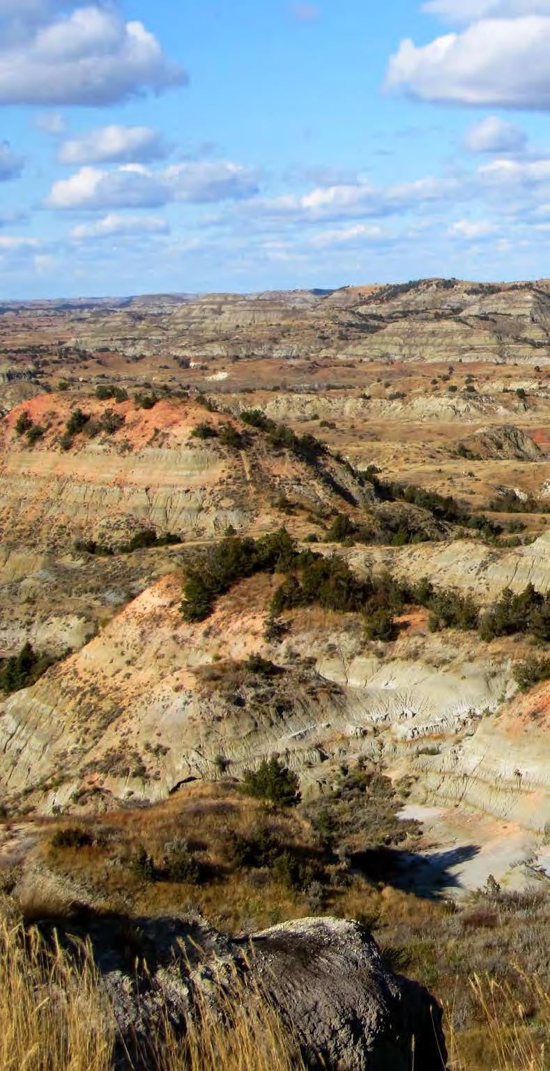
2 Williston Crossing, located in northwest North Dakota, is an exciting mixed use development planned to meet the escalating need for retail, entertainment and housing in the flourishing Williston area, focused on the opportunities and advantages provided by that extraordinary growth. These development plans incorporate best practices in order to create a unique development positioned to become an important retail center in the region with the additional land uses necessary to ensure its success. Williston Crossing will occupy a 218 acre site due north of downtown Williston in Williams County, just 5 miles from the future airport and closely accessed by the new bypass. The site is west of US Highway 2, south of 58th Street NW, east of 137th Avenue NW and north of 57th Street NW. Fendee Residential estates is located just north of the site, while Northstar occupies the site to the south. The well positioned site, with easy access and 180 degree views is perfectly situated for a retail driven mixed use project. The natural beauty of the site will be complemented by regionally inspired design conceptualized as Dakota Modern. The site s surrounding grasslands and prairies are the inspiration for the landscape concept for Williston Crossing, providing for an integrated manmade and natural landscape. Open spaces within the project, including the streets, parks, perimeter and even detention basins will reinforce the beauty of the natural environment. A central park, anchoring the development, will provide a center for a variety of programmed activities for neighbors and the community. The development will incorporate sustainable strategies and community oriented amenities and include over 900 housing units, 600,000 square feet of commercial space, almost 1 million square foot of retail and four hotels, one of which will host a water park. The mix of uses will ensure a thriving, sustainable and successful development. Williston Crossing will enhance the quality of life for Williams County residents and those in the broader region by bringing a wider range of retail, hotel, entertainment and housing options to the area. It will create jobs that diversify employment in the County. Both of these by products will serve to increase local tax revenues. The carefully conceived project, spearheaded by local investors, will provide long term benefits to Williams County. 1 PROJECT NARRATIVE

3 Create a Strong Sense of Place Strong sense of community gathering Family-oriented Integrate the Man-made and Natural Environments Work with natural features Minimize impermeable surfaces Create a Financially Sustainable Development Develop a phasing plan for long-term success Utilize a mix of uses Integrate High Quality Design Timeless Wow factor Detailing and workmanship Regionally inspired material palette 2 PLANNING PRINCIPLES


4 5 3 4 DAKOTA MODERN NATURAL, ORGANIC MATERIALS EVOKING THE GREAT PLAINS WITH GLASS AND EXPANSIVE VIEWS TO THE SKY.

5 6 Dakota Modern embodies the natural, understated beauty of the Great Plains. Dakota Modern is beautiful, open spaces that encourage warmth, community and comfort. Dakota Modern employs the clean lines and thoughtful simplicity of modern design, but is softened by organic shapes and textures evoking the local landscape. Regional materials, a natural color palette and expansive glass planes conjure the rugged beauty and vast blue sky openness of the prairies and Badlands.

6 AERIAL VIEW major ComPREHENSIVE PLAN AMENDMENT PRESENTATION 01/27/2015 Triton Asset Group, LLC Williston Crossing Williams County, North Dakota 6


7 7 REGIONAL CHARACTER LOCAL STYLE

8 SITE ANALYSIS
9 Points of Interest Williston City Hall Amtrak Depot Bus Depot Sloulin Field International Airport Future Airport - to be completed 2017 Mountrail-Williams Electric Cooperative Downtown Million Dollar Way Four Mile Corner E. Broadway Industrial Park Williston Rail Park Spring Lake Park Developments Fendee Estates Northstar Center Bakken Industrial Park The Meadows Missouri Meadows Badlands Town Center Roseland Subdivision Fairhills Development Harvest Hills Granite Peak Subdivision Sand Creek Town Centre Chandler Field/Gateway Shops Dakota Crossing Future Truck Bypass Preferred Location of Future Airport County Rd. 7 County Rd. 6 Future Truck Bypass 137th Ave. NW City Limits 1 1 PROJECT SITE 7 58th St. NW 57th St. NW 6 2 City Limits F 3 42nd St. W. 42nd St. E. 4 5 Little Muddy County Rd. 9 Heavy Commerical Commerical Residential State Highway Secondary Road Future Truck Bypass Existing Railroad City Limits County Rd. 4 City Limits Bison Dr. 26th St. W. 16th Ave. W. 13 9th Ave. NW. 18th St. W. B Main St. 26th St. E. 18th St. E. A University University 11th St. W. 11th St. E. 9th Ave. W. City Limits 2nd Ave. W W. Broadway 2nd St. W. East Dakota Parkway D 13th Ave. E. E. Broadway City Limits E Links of North Dakota 28 miles east Confluence Historical sites 25 miles southwest C Missouri River 0 1/4 1/2 1 2 MILES WILLISTON CONTEXT major ComPREHENSIVE PLAN AMENDMENT PRESENTATION 01/27/2015 Triton Asset Group, LLC Williston Crossing Williams County, North Dakota 9
 RESIDENTIAL (E) OIL WELL 58TH ST NW LEGEND Property Line Dirt Road Major Access Road State Highway Proposed NW Truck Bypass 137TH AVE NW PROJECT SITE U.S. HWY 2/85 57TH ST")
10 FENDEE ESTATES (UNDER CONSTRUCTION) RESIDENTIAL (E) OIL WELL 58TH ST NW LEGEND Property Line Dirt Road Major Access Road State Highway Proposed NW Truck Bypass 137TH AVE NW PROJECT SITE U.S. HWY 2/85 57TH ST NW TO FUTURE AIRPORT NORTHSTAR CENTER (FUTURE SITE) MIXED-USE BAKKEN INDUSTRIAL PARK LOCAL CONTEXT major ComPREHENSIVE PLAN AMENDMENT PRESENTATION 01/27/2015 Triton Asset Group, LLC Williston Crossing Williams County, North Dakota 10
11 8 WILLISTON CROSSING Williams County, North Dakota MASTER PLAN

12 ROAD TO FENDEE ESTATES DEVELOPMENT 58TH ST NW LEGEND: A MULTI-FAMILY/COURTYARD A B C D MULTI-FAMILY//SWIMMING POOL DETENTION BASIN CORRIDOR DUPLEX B D C F E G J S E F G H I LAWN OPEN SPACE TOWNHOME VEHICLE DROP-OFF LANE THEATER ACCENT PAVER CENTRAL CORRIDOR Q J ANCHOR TENANT 137TH AVE NW H I K L K L LAWN OPEN SPACE RESTAURANTS J M N M N ENTRANCE CORRIDOR RETAIL O HOTEL O P DETENTION BASIN R P Q ACCENT PAVER CROSSING R OFFICE P S BIG BOX RETAIL SCALE: 1 =500-0 ILLUSTRATIVE MASTER PLAN major ComPREHENSIVE PLAN AMENDMENT PRESENTATION 01/27/2015 Triton Asset Group, LLC Williston Crossing Williams County, North Dakota 12
13 OPEN SPACE PLAN major ComPREHENSIVE PLAN AMENDMENT PRESENTATION 01/27/2015 Triton Asset Group, LLC Williston Crossing Williams County, North Dakota 13
14 PHASING PLAN major ComPREHENSIVE PLAN AMENDMENT PRESENTATION 01/27/2015 Triton Asset Group, LLC Williston Crossing Williams County, North Dakota 14


15 CONCEPT IMAGES: D A B C D F G H I J K L G E SCALE: 1 =100-0 LEGEND: KEY PLAN: A FOUNTAIN G SCULPTURE B LAWN OPEN SPACE H DARK TAN CONCRETE PAVER C GLASS ENCLOSED CENTRAL ATRIUM I LIGHT TAN CONCRETE PAVER PEDESTRIAN LANE D KIOSK J FLOWER BED E RIVER WITH BRIDGE K LIGHT F BROWN CONCRETE PAVER STRIP L LANDSCAPE WALL RETAIL CENTER CONCEPT major ComPREHENSIVE PLAN AMENDMENT PRESENTATION 01/27/2015 Triton Asset Group, LLC Williston Crossing Williams County, North Dakota 15


16 CONCEPT IMAGES: J K L M A B C D E F G I H SCALE: 1 =100-0 LEGEND: KEY PLAN: A DETENTION BASIN G BROWN CONCRETE PAVE BAND M PLANTING BED B CONCRETE TERRACE WALL H LANDSCAPE WALL C NATURAL PLANTING AREA I LIGHT GREY CONCRETE PAVER D DARK TAN CONCRETE PAVER J BROWN CONCRETE PAVER E LIGHT TAN CONCRETE PAVER K PLANTING BED F LAWN OPEN SPACE L LIGHT GREY CONCRETE PAVER RESIDENTIAL CONCEPT major ComPREHENSIVE PLAN AMENDMENT PRESENTATION 01/27/2015 Triton Asset Group, LLC Williston Crossing Williams County, North Dakota 16

17 8 WILLISTON CROSSING Williams County, North Dakota THANK YOU
18 1. Douglas_Schulze7th by THRONPS available at under a Creative Commons Attribution-NonCommercial 2.0 Generic License. Full terms at 2. Santana Row by Erik Fredericks available at under a Creative Commons Attribution-ShareAlike 2.0 Generic License. Full terms at 3. Harvesting at Floors Farm by Anne Burgess available at under a Creative Commons Attribution-ShareAlike 2.0 Generic License. Full terms at 4. Cumulus Clouds over Yellow Prairie by Wing-Chi Poon available at under a Creative Commons Attribution-ShareAlike 2.5 Generic License. Full terms at 5. BadlandsView3 original uploaded by Wereldburger758 (transferred by Citypeek) available at under a Creative Commons Attribution-ShareAlike 3.0 Unported License. Full terms at 6. Prairie near Brooks by Brett Snyder available at under a Creative Commons Attribution 1.0 Generic License. Full terms at 7. Douglas_Schulze7th by THRONPS available at under a Creative Commons Attribution-NonCommercial 2.0 Generic License. Full terms at 8. Kim_WehnerGrandPrize by THRONPS available at under a Creative Commons Attribution-NonCommercial 2.0 Generic License. Full terms at Gensler 500 South Figueroa Tel Los Angeles CA Fax USA
19
Mariposa Lakes. Planned Community. Project Overview. Stockton, CA
 Planned Community Stockton, CA Project Overview March 2007 Summary of Proposed Community is a master-planned community proposed for development on approximately 3,810 acres in southeast Stockton. In 2004,
Blue Line LRT Extension
 v e Noble Pkwy Noble Pkwy Xerxes Ave N Shingle Creek Penn Ave N Penn Ave N Fremont Ave N Lyndale Ave N S Washington Ave University Ave NE Blue Line LRT Extension LIGHT RAIL PLATFORM AND STATION DESIGN
Northwest Rail Corridor and US 36 BRT Development Oriented Transit Analysis 4.4 STATION AREA FINDINGS
 4.4 STATION AREA FINDINGS Each station is different, and each one requires a separate set of recommendations based on the vision for the site. This section outlines an initial TOD strategy and recommendations
Cleveland Park Streetscape and Drainage Improvement Project 1
 Cleveland Park Streetscape and Drainage Improvement Project 1 Urban Context Washington, D.C. Connecticut Avenue Cleveland Park Streetscape and Drainage Improvement Project 2 Neighborhood Context Contributing
PC RESOLUTION NO ARCHITECTURAL CONTROL (AC)
") PC RESOLUTION NO. 16-07-26- ARCHITECTURAL CONTROL (AC) 15-035 A RESOLUTION OF THE PLANNING COMMISSION OF THE CITY OF SAN JUAN CAPISTRANO, CALIFORNIA APPROVING ARCHITECTURAL CONTROL (AC) 15-035, INN AT
PC RESOLUTION NO. 16-07-26- ARCHITECTURAL CONTROL (AC) 15-035 A RESOLUTION OF THE PLANNING COMMISSION OF THE CITY OF SAN JUAN CAPISTRANO, CALIFORNIA APPROVING ARCHITECTURAL CONTROL (AC) 15-035, INN AT
ROBBINSDALE LRT STATION CDI DEVELOPMENT GUIDELINES
 August 2018 OVERVIEW The City of Robbinsdale has a prime-opportunity site in the middle of the 13 mile stretch of the Bottineau LRT corridor / Blue Line extension. Robbinsdale offers a prominent, vital,
Planning Districts INTRODUCTION
 INTRODUCTION To facilitate detailed examination of development prospects for all areas of the community, Delano has been divided into 14 planning districts. The location of these planning districts is
Policies and Code Intent Sections Related to Town Center
 Policies and Code Intent Sections Related to Town Center The Town Center Vision is scattered throughout the Comprehensive Plan, development code and the 1994 Town Center Plan. What follows are sections
A Plan for the Heart of the Region: Tukwila, WA
 : Tukwila, WA 1 The Plan orchestrates the Restructuring of a 1,000-acre Regional Shopping Area into a Social and Symbolic for the Region. REGIONAL CONTEXT Downtown Seattle (Metropolitan ) 20 miles Bellevue
Lower South Street/Louisa Street Charrette Final Presentation. September 22, 2009
 Lower South Street/Louisa Street Charrette Final Presentation September 22, 2009 Recap Mayor and Council called for a Charrette to engage the public on creating a vision for the Lower South Street area.
Master Site Development Plan (MSDP) Rocky View County Campus at Balzac East
 Rocky View County Campus at Balzac East") Master Site Development Plan (MSDP) Rocky View County Campus at Balzac East Balzac East, Alberta July 2009 CONTENTS 1.0 purpose 1 2.0 guiding principles 2 3.0 site description 3 4.0 site analysis and county
Master Site Development Plan (MSDP) Rocky View County Campus at Balzac East Balzac East, Alberta July 2009 CONTENTS 1.0 purpose 1 2.0 guiding principles 2 3.0 site description 3 4.0 site analysis and county
EcoVerde MADISON TO DOWNTOWN TO BEACH. Legend Highway Major Connection Major Street Local Street Proposed Access. Response to Tropicana Field RFP
 EcoVerde TO BEACH 275 16th Street North 16th Street South 13th Street North 13th Street South 11th Street North 11th Street South 1st Avenue North Central Avenue 1st Avenue South TO DOWNTOWN 2nd Avenue
DRAFT ROOSEVELT ROAD. District Recommendations. Figure 5.23 The Roosevelt Road Corridor
 CHAPTER 5 Figure 5.23 The Road Corridor Road will develop as a mixed-use corridor, emphasizing regional retail, west of the river and mixed-use development east of the river. KEY RECOMMENDATIONS 1. High
PROJECT DESCRIPTION. Providing a mix of housing options supporting a diversity of needs (800-1,600 sf 1-3 bd flats and Townhomes).
.") ROHNERT PARK Planned Development - Preliminary Application Project Site LOCATION MAP Project Site Rohnert Crossings is a acre mixed-use urban village proposed in the center of the city adjacent what will
ROHNERT PARK Planned Development - Preliminary Application Project Site LOCATION MAP Project Site Rohnert Crossings is a acre mixed-use urban village proposed in the center of the city adjacent what will
COMMUNITY DESIGN. GOAL: Create livable and attractive communities. Intent
 COMMUNITY DESIGN Intent An attractive, well-designed County will attract quality development, instill civic pride, improve the visual character of the community, and create a strong, positive image for
Brampton. Secondary Plan. Review. Bram West. A New Direction in Planning & Public Consultation
 Brampton Bram West Secondary Plan Review A New Direction in Planning & Public Consultation Introduction The Bram West Secondary Plan Review offers an important opportunity for the community to define a
Strategic Growth Area #1 Northampton Boulevard Corridor Area
 Strategic Growth Area #1 Northampton Boulevard Corridor Area Description Strategic Growth Area #1 has established itself as a major employment center in Southside Hampton Roads. Opportunities exist to
Elm Fork Land Use. Trinity River Corridor Project Committee May 13, 2013
 Elm Fork Land Use Trinity River Corridor Project Committee May 13, 2013 Purpose Discuss Trinity River planned Land Use and Appropriate Compatible Uses, particularly with respect to the Elm Fork Area 2
Robbinsdale LRT Station. CDI Development Guidelines. August Overview
 Robbinsdale LRT Station August 2018 Overview The City of Robbinsdale may have the coolest opportunity site along the 13 mile stretch of the Bottineau LRT corridor / Blue Line extension. Located a block
Access to the University of North Carolina at Chapel Hill, UNC Hospitals, and Chapel Hill Transit.
 M 1/ 4 1/ 2 E IL M E IL Station Family: County: City: UNC Hospitals WHY THIS STATION? University Village Orange Chapel Hill Access to the University of North Carolina at Chapel Hill, UNC Hospitals, and
THE NEIGHBORHOOD TODAY
 THE NEIGHBORHOOD TODAY CORE AREA VISION How are we Good Urbanism A Site s DNA thinking about Elements of great Unique elements urban communities embedded in a place the site and design? ELEMENTS LIKE:
BROOKLYN PARK / 85TH AVE LRT STATION CDI DEVELOPMENT GUIDELINES DRAFT
 August 2018 Page intentionally left blank The Brooklyn Park Library adjacent to the 85th Ave LRT Station Area. OVERVIEW The Blue Line LRT Extension / Bottineau corridor offers a unique opportunity to leverage
Tools for Implementing your Comprehensive Plan. Josh Campbell City of Suwanee Planning and Inspections
 Tools for Implementing your Comprehensive Plan Josh Campbell City of Suwanee Planning and Inspections Tools for Implementing your Comprehensive Plan Planning Expectations and Culture Policies Regulations
The Village of Shirlington
 The Village of Shirlington Suburban Smart Growth Without Rail Transit July 2018 Agenda History (1940 to present) Attributes and Outcomes Lessons Learned Setting the Stage Arlington County Arlington is
Mark-up of the effect of the proposed Bronte Village Growth Area OPA No.18 on the text of section 24, Bronte Village, of the Livable Oakville Plan
 Mark-up of the effect of the proposed Bronte Village Growth Area OPA No.18 on the text of section 24, Bronte Village, of the Livable Oakville Plan Notes: This document is provided for information purposes
Reconnecting to a Forgotten River St. Cloud MN. Aaron Hanson Design Design Thesis LA 572, Thesis, Spring 2012
 Reconnecting to a Forgotten River St. Cloud MN Aaron Hanson Design Design Thesis LA 572, Thesis, Spring 2012 site context 2.5 Miles Sartell St. Cloud to Fargo 170 Miles (2 hrs 45 mins) Hwy 10 infrastructure
EXISTING COMPREHENSIVE PLAN
 EXISTING COMPREHENSIVE PLAN Town Center Land Use Element: V. LAND USE POLICIES Town Center Mercer Island's business district vision as described in "Your Mercer Island Citizen-Designed Downtown" was an
Appendix 1. Private Projects with Respective On Site PUS and Public Parks in the Silver Spring CBD
 Appendix 1 Private Projects with Respective On Site PUS and Public Parks in the Silver Spring CBD Green Space Guidelines for the Silver Spring Central Business District montgomery county planning board,
CHAPTER 7: Transportation, Mobility and Circulation
 AGLE AREA COMMUNITY Plan CHAPTER 7 CHAPTER 7: Transportation, Mobility and Circulation Transportation, Mobility and Circulation The purpose of the Transportation, Mobility and Circulation Chapter is to
VICTORIA DOWNTOWN DEVELOPMENT PLANNING
 VICTORIA DOWNTOWN DEVELOPMENT PLANNING A Vision & Guide for the Future Downtown Victoria thrives as a center for the community, offering a great mix of entertainment, culture, business, and recreational
DISCOVER KIRBY GROVE
 5 R I C H M O N D AV E, H O U S TO N DISCOVER KIRBY GROVE Within the Upper Kirby District, the mixed-use Kirby Grove destination features culinary concepts from renowned chefs, luxury mid-rise residences,
SYRINGA VALLEY SPECIFIC PLAN NARRATIVE
 SYRINGA VALLEY SPECIFIC PLAN NARRATIVE Introduction With this application, Pleasant Valley South LLC ( Pleasant Valley ) seeks the City of Boise s approval of a new Specific Plan Ordinance to be added
EXECUTIVE SUMMARY DRAFT CHAPTER 1 INTRODUCTION EXECUTIVE SUMMARY
 CHAPTER 1 EXECUTIVE SUMMARY INTRODUCTION Through the joint efforts of the City of Tulsa planning staff and the Land Services division of Indian Nations Council of Governments (INCOG), the Berryhill Land
Port Lavaca Future Land Use
 Port Lavaca Future Land Use Introduction The City of Port Lavaca is beginning to see sustained growth, after many years of relative stable population. New single family homes, apartments, and businesses
Small Area Plan. South Gateway
 Small Area Plan Adopted May 12, 2008 South Gateway Purpose. The South Gateway Small Area Plan defines the City s expectations for the future of the southern entrance to the City at Interstate 85 and Highway
RESOLUTION NO R
 e e RESOLUTION NO R04 0054 BE IT RESOLVED by the Mayor and City Council ofthe City ofpapillion that The Papillion Comprehensive Plan is hereby amended to incorporate the Option A Future Land Use Map Transportation
Developer s Program. The Station at East 54
 Developer s Program The Station at East 54 Existing Conditions The Station at East 54 is proposed for a 1.12 acre site at the northeast corner of Hamilton Road and Prestwick Road, tucked between the East
2.0 AREA PLANS. Lakeside Business District. Lakeside Business District Land Use Categories:
 Lakeside Business District Lakeside Business District Land Use Categories: Campus Commercial Campus Commercial means a mixture of uses which includes corporate offices, office parks, hotels, commercial,
SECTION TWO: Urban Design Concepts
 SECTION TWO: Urban Design Concepts The Gardnerville Plan for Prosperity shapes economic opportunities presented by regional growth. The Urban Design Concepts provide policies and concepts for land use,
What Pioneer Grove Will Look Like?
 The City of Deerfield Beach has embarked on a journey to create a new town center within the old heart of Deerfield Beach. The new town center is known as Pioneer Grove. Pioneer Grove will be Everybody
CHAPTER 1. Ms. Guajardo s Class - Central Elementary CH 1 1
 INTRODUCTION CHAPTER 1 Ms. Guajardo s Class - Central Elementary CH 1 1 1.1 SETTING South Centre City is a linear corridor south of Downtown Escondido paralleling Centre City Parkway and South Escondido
EL CORAZON AQUATICS CENTER
 EL CORAZON AQUATICS CENTER CONTENT EL CORAZON AQUATICS CENTER 3 4 6 8 10 INTRODUCTION SITE PLANNING AQUATICS PROGRAM PUBLIC EXPERIENCE VISION The proposed El Corazon Aquatics Center in Oceanside will be
GAMMAGE SQUARE - RECOMMENDATIONS
 GAMMAGE SQUARE - RECOMMENDATIONS We envision an expanded cultural district surrounding the historic ASU Gammage. Creating a cultural district will enhance the existing historic landmark by activating the
Sub Area 2: Downtown Overland Park
 Downtown 132 2.12 encompasses over 600 acres and extends between 71st Street and 87 th Street including Downtown Overland Park. The area is home to several individual historic sites and structures, including
Table of Contents. Elm Avenue Improvement Plan City of Waco, Texas. Introduction 1. Existing Context 1 Figure 1 2.
 Table of Contents Introduction 1 Existing Context 1 Figure 1 2 Plan Guidelines 3 Future Urban Form 4 The West-End 4 Main Street 6 The East-End 7 Figure 2 9 Public Improvement Recommendations 7 General
Welcome to Greenwood Village Corporate Capital of Colorado
 Welcome to Greenwood Village Corporate Capital of Colorado Greenwood Village Setting Incorporated: 1950 Land Area: 8.4 sq. miles + / - Budget $35M Debt $0 Reserve $20M Population Daytime: 50,000 Residents:
City of Farmington. Downtown Plan. Amendment to the 1998 Master Plan Adopted October 11, 2004
 City of Farmington Amendment to the 1998 Master Plan Adopted October 11, 2004 Introduction Planning Background 1 Scope and Components of the Plan Amendment 2 Concept Introduction 3 Plan Concepts 3 Conceptual
1375 Sunflower Ave Costa Mesa, CA Delivery Q1 2020
 1375 Sunflower Ave Costa Mesa, CA www.thepress.com Delivery Q1 2020 THE PRESS The press facility in 1968. Courtesy Costa Mesa Historical Society. From ruins to reinvention, the existing historical architecture
Welcome! to Keller Town Hall
 Welcome! to Keller Town Hall Keller Town Center Planning a New Downtown What is Keller Town Center? A new, growing downtown district planned as an urban village A combination of retail and office spaces,
appendix and street interface guidelines
 appendix five: building and street interface guidelines appendix 5 building and street interface guidelines BOULEVARDS Boulevards are generally characterized by higher levels of traffic movement at higher
Washington Plaza at the. Lake Anne Village Center
 Lake Anne Village Center Washington Plaza Design Charrette Washington Plaza at the Lake Anne Village Center Process and Recommendations Presentation to the Reston Association Board of Directors January
Glenborough at Easton Land Use Master Plan
 Vision Statement Sunrise Blvd. Hazel Ave. Prairie City Rd. Gencorp Property Lincoln Regional Airport 1.0 VISION STATEMENT The identifies City of the principles, goals, policies, and standards Lincoln that
Section4 Design Vision & Implementation Plan
 Section4 Design Vision & Implementation Plan W Woodschurch Rd 4.1 Design Focus Areas The Framework Plan is simply the starting point for directing the design and implementation of a wide range of transportation
AIRPORT BUSINESS PARK
 PIER MAC PETROLEUM INSTALLATION LTD. AIRPORT BUSINESS PARK DEVELOPMENT APPLICATIONS March 2003 4.1 Airport Business Park Development Permit Area 4.1.1 Justification/Design Concept The design concept envisioned
Further input invited as Colchester Growth Strategy nears final phase
 IUE 3 / NOVEMBER 2015 Further input invited as Colchester Growth trategy nears final phase trathcona County is seeking public feedback as it enters the final phase of work on a Growth Management trategy
Century Park to Ellerslie Road Preliminary Engineering
 Century Park to Ellerslie Road Preliminary Engineering South LRT Extension Stakeholder Information Panel Brochure March 2010 www.edmonton.ca/lrtprojects LRT Station (left) and Transit Centre Architectural
Grand Junction, Colorado
 Grand Junction, Colorado Brought to you by: THE RIVERFRONT STORY RIVERFRONT at las colonias PARK offers the next generation company and workforce an immersive experience geared toward wellness, community
Easton. Smart Growth Through Innovation. Easton
 Hazel Ave. Sunrise Blvd. Prairie City Rd. Smart Growth Through Innovation offers a unique opportunity to meet the region s future need for jobs and housing. It embodies smart growth principles advocated
[PLANNING RATIONALE] For Site Plan Control and Lifting of Holding Zone By-Law 101 Champagne Avenue. May 23, 2014
![[PLANNING RATIONALE] For Site Plan Control and Lifting of Holding Zone By-Law 101 Champagne Avenue. May 23, 2014](/thumbs/75/71599615.jpg "[PLANNING RATIONALE] For Site Plan Control and Lifting of Holding Zone By-Law 101 Champagne Avenue. May 23, 2014") [PLANNING RATIONALE] For Site Plan Control and Lifting of Holding Zone By-Law 101 Champagne Avenue May 23, 2014 Contents 1.0 Introduction... 2 2.0 Site Context... 2 2.1 Adjacent Uses... 2 Figure 1: Site
[PLANNING RATIONALE] For Site Plan Control and Lifting of Holding Zone By-Law 101 Champagne Avenue May 23, 2014 Contents 1.0 Introduction... 2 2.0 Site Context... 2 2.1 Adjacent Uses... 2 Figure 1: Site
Today Land & People. Northeast Nampa Gateway District. Employment. Land Use Characteristics. Demographics. Current Zoning
 Today Land & People Employment Major employers include Saint Alphonsus, the College of Western Idaho, the Auto Mall, Sorrento Lactalis and Walmart. 3,004 jobs in 2010 (COMPASS-CIM 2040 TAZ data) 4,345
Metro Orange Line Extension Four Years Early and $61 Million Under Budget
 White Paper: Metro Orange Line Extension Four Years Early and $61 Million Under Budget July 2013 Innovation for better mobility Metro Orange Line Extension Iteris, Inc. was the prime consultant leading
A BEAUTIFUL PLACE FOR LIVING
 A BEAUTIFUL PLACE FOR LIVING BEAULIEU: A PLACE FOR LIFE Beaulieu is a vibrant new district taking shape in Chelmsford, Essex; offering residents inspirational architecture and landscape. Developers Countryside
Land Use. Hardware Street Vendor Mixed-Use
 Land Use Definition Land Use is the way a piece of real estate is utilized. Existing, proposed, and adopted land uses all play a role in the planning process. Once a land use plan is adopted, the next
Jason D. Sutphin, Community Development Division Chief. Through: Brooke Hardin, Director of Community Development and Planning
 Meeting Date: 12/18/2017 Agenda Item: 9a. MEMORANDUM To: Chairman Cunningham and Members of the Planning Commission From: Jason D. Sutphin, Community Development Division Chief Through: Brooke Hardin,
Taming Tysons Corner Transforming the Quintessential Edge City
 Taming Tysons Corner Transforming the Quintessential Edge City Transit is the greatest catalyst for change at Tysons, but how do we take advantage of this billion-dollar investment? If transit is built
The Master Plan Framework
 The Master Plan Framework The East Harbour Master Plan advances the development of 60 acres of former industrial lands east of the Don River. The Master Plan outlines a vision for a vibrant, transit-oriented
Chapter V-Transportation
 Town of Vernon 2026 Smart Growth Plan Chapter V-Transportation DEVELOPMENT OBJECTIVES Transportation System Objective - To provide an integrated transportation system which, through its location, capacity,
DENVER DESIGN DISTRICT GDP
 DENVER DESIGN DISTRICT GDP Urban Design Standards and Guidelines November 17, 2008 Amended February 3, 2016 City and County of Denver CF Property Management, Inc. C/O Denver Design District - Starboard
POCKET COMMUNITY PLAN
 POCKET COMMUNITY PLAN Part Three : COMMUNITY PLAN AREAS AND SPECIAL STUDY AREAS CONTENTS Community Location... 3-P-3 Community Vision... 3-P-4 Community Profile... 3-P-4 Community Issues... 3-P-6 Land
ALTERNATIVE STATION AREA -
 ALTERNATIVE STATION AREA - THE 10 TH STREET GARDEN STATION Two alternative land use scenarios and designs are illustrated here: Scheme A - Transit-Oriented Development High to Mid-Density Residential /Office
Historic Preservation Preserve, restore or adaptively re-use historic structures and landscapes.
 Checklist for New Construction Developers of building projects in the Loring Park Neighborhood are encouraged to pursue the standards that are identified below. For large projects requiring special allowances,
SARANAC LAKE VISION CONCEPTS
 DRAFT SARANAC LAKE VISION CONCEPTS A GENUINE PLACE TO LIVE, WORK, SHOP AND EXPERIENCE CULTURE IN THE HEART OF THE ADIRONDACKS PHOTO COURTESY OF SARANAC LAKE SARANAC LAKE, NEW YORK DECEMBER 2007 SARANAC
The Warehouse District in West Palm Beach is comprised of approximately 85,000 square of previously underutilized warehouse / industrial buildings in
 The Warehouse District in West Palm Beach is comprised of approximately 85,000 square of previously underutilized warehouse / industrial buildings in downtown being reimagined and redeveloped into a thriving
Comprehensive Plan Advisory Panel Meeting #3
 Comprehensive Plan Advisory Panel Meeting #3 November 7, 2016 Agenda 1. September 19 th Meeting Notes 2. Summary of Focus Areas Charrette 3. Heart of the City Focus Area a. HOC2/Station Areas Concept &
SQUAMISH 2010 AND BEYOND COMMUNITY VISION
 Our plan has been imagined and created to be both pragmatic and visionary. At the core of the strategy is a consideration of the highway s role and its impact on the community. First and foremost in creating
City of Redlands Architectural Guidelines for Non-Residential Development
 14. Building articulation shall be included in the design of building, in order to create a formal entry statement. Avoid this Do this Page 11 15. Give special attention to creating pedestrian scale and
Now Pre-Leasing N. Salem Street. 17,000 sf $23.50/sf. NEW CONSTRUCTION Professional Office. Apex, NC, Highlights
 NEW CONSTRUCTION Professional Office 1950 N. Salem Street Apex, NC, 27502 Now Pre-Leasing 17,000 sf $23.50/sf Highlights 17,000 sf Two-story, professional office building $23.50 sf full service Easy access
Mississippi Skyway Preliminary Engineering Report
 EXECUTIVE SUMMARY Mississippi Skyway Preliminary Engineering Report CITY OF RAMSEY, MINNESOTA DECEMBER 2014 City of RAMSEY EXECUTIVE SUMMARY Project Need and Intent The Mississippi Skyway pedestrian bridge
September 25th, 2018 $2000 fee pd CC
 2.7267 acres 2018I-00075 September 25th, 2018 $2000 fee pd CC Rezoning Review Criteria Analysis - Map Amendment Application Number: 2018I-00075 805 W. 38 th Avenue October 19, 2018 (amd.) September 17,
LAND PARK COMMUNITY PLAN
 LAND PARK Community Plan Part Three : COMMUNITY PLAN AREAS AND SPECIAL STUDY AREAS SACRAMENTO 2030 GENERAL PLAN Contents Community Location...3-LP-3 Community Vision...3-LP-4 Community Profile...3-LP-4
1375 Sunflower Ave Costa Mesa, CA Delivery Q1 2020
 1375 Sunflower Ave Costa Mesa, CA www.thepresscostamesa.com Delivery Q1 2020 THE PRESS The press facility in 1968. Courtesy Costa Mesa Historical Society. From ruins to reinvention, existing historical
A. VOLUME I 2) DETAILED PLANS c) LANDSCAPE PLANS i) Open Space and Pathways Plan
 DETAILED PLANS c) LANDSCAPE PLANS i) Open Space and Pathways Plan") i) Open Space and Pathways Plan Fire Station Bizek Property Heritage Homestead Foundation Penitentiary Canal United Water Reservoir Idaho Power Corridor Trail Existing Trailhead Squaw (Spring) Creek Trail
i) Open Space and Pathways Plan Fire Station Bizek Property Heritage Homestead Foundation Penitentiary Canal United Water Reservoir Idaho Power Corridor Trail Existing Trailhead Squaw (Spring) Creek Trail
TRANSIT NEIGHBORHOOD PLANS PROGRAM OVERVIEW
 TRANSIT NEIGHBORHOOD PLANS PROGRAM OVERVIEW OCTOBER 2017 Los Angeles Department of City Planning @LATNP and @Planning4LA Outline Introduction Policy Framework The Transit Neighborhood Plans Program Overview:
ORANGE COUNTY IMPLEMENTING THE FOUR C s
 ORANGE COUNTY IMPLEMENTING THE FOUR C s East Central Florida Corridor Task Force O R A N G E COUN TY P LA N N I N G DIVISION C O M M U N I T Y, E N V I R O N M E N T A L A N D D E V E L O P M E N T S E
Planning Commission Staff Report June 5, 2008
 Owner/Applicant Taylor Village Sacramento Investments Partners, LP c/o Kim Whitney 1792 Tribute Road #270 Sacramento, CA 95815 Staff Recommendation Planning Commission Staff Report Project: File: Request:
FLOOD ISSUE 62 INTRODUCTION
 V I S I O N 2 0 3 0 Southwest Missouri is known for its extreme range in weather that can cause flash flooding in a moment s notice. This flooding can unfortunately lead to extreme damage and serious injury,
ITEM #8. Regional Smart Growth Program. Regional Smart Growth Program. Presentation Overview. Coast Highway Vision and Stategic Plan.
 Regional Smart Growth Program Economic Development Commission What is Smart Growth? Adopted as part of the Regional Comprehensive Plan (RCP) RCP provides vision for region based on Smart Growth and sustainability
A P P E N D I X B - O P P O R T U N I T Y S I T E S
 A P P E N D I X B - O P P O R T U N I T Y S I T E S OPPORTUNITY SITES As listed in the Land Use Element, the City has identified 15 Opportunity Sites expected to be the focus of change and revitalization
16. Peckham Peckham Area Vision
 16. 16.1. Area Vision 16.1.1. is: A lively town centre providing a range of daytime and night time activities on Rye Lane including a Library, a Leisure Centre and many independent retailers which specialise
Staff Report and Recommendation
 Community Planning and Development Planning Services 201 W. Colfax Ave., Dept. 205 Denver, CO 80202 p: 720.865.2915 f: 720.865.3052 www.denvergov.org/cpd TO: City Council Neighborhoods and Planning Committee
Without leaps of imagination or dreaming, we lose the excitement of possibilities. Dreaming, after all, is a form of planning.
 City of Garden Grove A Publication for Garden Grove Residents and Businesses Fall 2014 Without leaps of imagination or dreaming, we lose the excitement of possibilities. Dreaming, after all, is a form
14 October 10, 2012 Public Hearing APPLICANT: MPB, INC
 14 October 10, 2012 Public Hearing APPLICANT: MPB, INC PROPERTY OWNER: MUNDEN & ASSOCIATES, LP STAFF PLANNER: Karen Prochilo REQUEST: Conditional Change of Zoning (AG-1 & AG-2 to Conditional O-2) ADDRESS
Eastcreek Farm. Planned Development Standards September, 2014
 Eastcreek Farm Planned Development Standards September, 2014 ekfarm Contents 01. General Standards 02. Residential Development Standards 03. Architectural Design Standards 04. Landscape Design Standards
Albert Lea. Redevelopment Plan. 701 Xenia Avenue South, Suite 300 Minneapolis, MN Tel: (763) Fax: (763) wsbeng.
 Fax: (763) wsbeng.") Albert Lea Redevelopment Plan 701 Xenia Avenue South, Suite 300 Minneapolis, MN 55416 Tel: (763) 541-4800 Fax: (763) 541-1700 wsbeng.com Albert Lea Redevelopment Plan Table of Contents Composite Districts...
Albert Lea Redevelopment Plan 701 Xenia Avenue South, Suite 300 Minneapolis, MN 55416 Tel: (763) 541-4800 Fax: (763) 541-1700 wsbeng.com Albert Lea Redevelopment Plan Table of Contents Composite Districts...
West Kendall Corridor June 11, 2014
 June 11, 2014 Miami-Dade County Department of Regulatory and Economic Resources Development Services Division ā 1 Presentation Outline Review Study Area Review of Citizens Plans and Presentations Planning
Draft Bergamot Area Plan
 ATTACHMENT 1 Draft Bergamot Area Plan Taskforce on the Environment April 15, 2013 www.bergamotplan.net 1 Overview WHAT IS THE BERGAMOT AREA PLAN? A Community-Based Planning Document Guiding the Future
12600 S Existing Conditions
 STUDY AREA BOUNDARY Study Area Boundary Study Area Context The District Riverton Meadows Vista Station Mountain View Village Market Center 2 Mile Radius 12600 S Existing Conditions 12600 S is a river of
urban design Introduction
 ACHIEVE SP RI NGF I ELD.3 Introduction Urban Design Areas Design Areas are areas within Springfield that have a unique and recognizable character that is different from other areas in the community. The
M E M O R A N D U M July 27, 2018
 M E M O R A N D U M July 27, 2018 To: Southlake 2035 Corridor Planning Committee From: Kenneth Baker, Sr. Director of Planning and Development Services Subject: Item #6 First National Bank Purpose Review,
Waterfront West December 6, 2016
 1 Waterfront West December 6, 2016 Agenda 1. Development Team 2. Waterfront History As Our Guide. A Compelling Site Idea 4. Community Benefits 5. Zoning 6. Architectural Context 7. Project Renderings 8.