Draft proposal for the future of St Brendan's Hospital, Grangegorman (23.5 MB)
|
|
|
- Lee Russell
- 6 years ago
- Views:
Transcription
1 Draft proposal for the future of St Brendan's Hospital, Grangegorman (23.5 MB) Item type Authors Rights Report Eastern Health Board (EHB) Estate Management Department Eastern Health Board Downloaded 11-Apr :19:56 Link to item Find this and similar works at -
2 DRAFT PROPOSAL FOR THE FUTURE OF ST. BRENDAN'S HOSPITAL, GRANGEGORMAN JUNE 1998 ESTATE MANAGEMENT DEPARTMENT
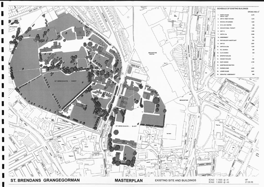
3 INTRODUCTION It has been our Board's policy and National Strategy over the past several years to reorganise the special hospital facilities away from the larger institutions such as St. Brendan's Hospital, Grangegorman. In the main this entails Acute facilities being provided in General Hospitals and supported by a whole range of Community based services in the various catchment areas throughout the Eastern Health Board area. This draft proposal suggests how the future of St. Brendan's relates to our Board's policy and makes recommendations as to its future use. Coinciding with our plans for St. Brendan's is a proposal from the Dublin Institute of Technology on their future needs and their identification of St. Brendan's as a possible solution to their requirements. The complex occupies approximately hectares (73.36 acres) and contains buildings of varying age, condition and use. From 1814 until the present day the hospital has been used for the treatment of psychiatric patients. Some of the buildings within the complex are now unused, derelict or demolished. In the near future most of the existing usable space will become redundant as the hospital contracts. As the hospital shrinks and relocates within the site, an area of hectares (63.39 acres) could become available for other use. 1
4 This could be one of the largest sites to be vacated within the Inner City in the present century. A masterplan for its future use is needed in order to protect and revitalise this important urban area. The purpose of the report is to re-assess the nature and condition of the entire site and its buildings and to consider a proposal for its possible future development. This report deals with St. Brendan's Hospital in three parts: 1) Existing Hospital Background and History (Map 1) 2) Future Patient Care, Facilities Requirements and the D.I.T. (Map 2) 3) Conclusions & Recommendations and Masterplan (Map 3) 2
5 PART 1 Existing Hospital Background and History 3
6 Site Location THE SITE The site of St. Brendan's Hospital is in the Arran Quay Ward in the district of Grangegorman, south of the Royal Canal and north of the River Liffey. The site as shown on Map No. 1 is located on both sides of Grangegorman Upper and is divided into two precincts known as St. Brendan's West and St. Brendan's East. St. Brendan's West encompasses an area of hectares (56.88 acres) and St. Brendan's East an area of 7.48 hectares (18.48 acres). The site extends from the North Circular Road on its northern boundary and almost reaches Brunswick Street North on its southern end. Its eastern edge is partly bounded by Broadstone Station: its western side is bounded by the buildings located along the east side of Prussia Street and Manor Street. The complex of buildings referred to on the latest ordnance maps as St. Laurence's Hospital, occupies a site adjacent to the south end of St. Brendan's East. This complex includes the buildings of the Whitworth and the Richmond Hospitals and the Legion of Mary Hostel. On this site the original House of Industry was built in From it sprang the Richmond Asylum, the forerunner of the present psychiatric hospital. 4
7 Site Frontage and Access St. Brendan's West has a northern boundary frontage of about 307 metres along the North Circular Road. Its eastern boundary frontage runs for some 637 metres along Grangegorman Upper. St. Brendan's East is virtually landlocked on its north, south and east sides. Its western frontage extends for almost 370 metres along Grangegorman Upper. The main and secondary entrances to the West site are from Grangegorman Upper. Individual buildings which are separate from the core complex are located along and accessible from the North Circular Road. The East site is presently entered through the old Richmond Penitentiary now known as the Annex. This access point is at the northern end of the site along Grangegorman Upper. A stone gateway, now disused, marks the entrance to the south west end of the site close to Grangegorman Lower. There is a secondary entrance to the site at its south eastern boundary via Mornina Star Avenue. 5
8 Topography and Geology The topography of the entire site is influenced by the valley of the Bradogue River in its course from Fingias to the Liffey. It sets the limits of the east boundary of the West site and runs across the southern end of the East site. The Bradogue was diverted underground in the 19 th century and runs in a brick culvert about 1.5 metres deep at a varying invert to ground level. The site of St. Brendan's West rises from its north east boundary to a ridge running east to west. It declines on an even gradient from this ridge towards its southern extremity. The east site slopes from the ridge downwards to its southern boundary. The highest point on the combined site is 29 a.o.d. and the lowest point is 15 a.o.d. The West and East sites share a common geology, "a palaeozoic bedrock zone of Mid Carboniferous limestone or calp with an average overburden of 5 metres". It is possible that part of the East site may be made - ground. 6
9 Landscape and Orientation The site is located on the upper reaches of a south facing slope of the Liffey Valley. The historical development of the site and its singular use have been responsible for its continued existence as a cultivated landscape. The extent of actual building within the site is small: buildings are freestanding surrounded generally by mature landscaping dating from the mid th 19 century. Part of the West site along its southern edge is presently occupied by playing pitches mostly under grass. Within the West site the buildings are located along the north and east sides on the east-west ridge and are set among trees and planted gardens. Much of the boundary frontages to the West site are tree lined. The East site contains the remains of a formal garden along its southern edge. The recent demolition of buildings in the centre of the site has left an area occupied only by rubble and scrub.
10 Site use and Condition Most of the hospital buildings presently in use are located in the West site. This area was developed from the mid 19 th century onwards when the East site has reached its built capacity. The earliest hospital building on the West site dates from 1849 and the latest from the 1960's. Many of these buildings are in good condition. Almost one third of the West site is used as playing fields. These are in constant use and provide the only large green space in a densely built-up area of the city. Many of the buildings on the East site have been demolished or are derelict. Still standing and in use are the Annex and the Nurses Home on the north-western side of the site along Grangegorman Upper. The southern end of the East site contained the original Richmond Lunatic Asylum, of which only the three storey stone-faced southern range known as the Lower House remains. Three of its ranges which completed the original quadrangle have recently been demolished. Much of the East site, especially at its southern end, is unused. The original formal gardens are in poor condition and the area between the Lower House and the Annex / Nurses Home is deserted. 8
11 THE HISTORY OF THE SITE AND ITS BUILDINGS The Development of the Site In 1773 the Corporation for the Relief of the Poor of the City of Dublin founded a House of Industry at Brunswick Street North. The purpose of the building was to house the mendicant and homeless population of the city. The building was expanded in the next decade and in the 1830's became known as the North Union Workshops. In 1806 an asylum for children, designed by Francis Johnston and named the Bedford Asylum, was built to the north of the House of Industry. This building together with the Hardwicke Fever Hospital and the Hardwicke Lunatic Cells were, by the early 1800's, inadequate for the treatment of mental patients. In 1810, the governors of the House of Industry decided to build a separate institution to house mental patients. The asylum was named the Richmond Lunatic Asylum after the Lord Lieutenant, Charles Lennox, 4 th Duke of Richmond. It was designed by Francis Johnston, Architect of the Board of Works and Civic Buildings and completed in This building is now known as the Lower House and is located at the southern end of the East site. 9
12 In the same year, 1810, Francis Johnston designed a General Penitentiary on the site north of the proposed Richmond Asylum. The building was completed in 1816 and known as the Richmond Penitentiary. The section of this building which remains intact is now known as the Annex. Until the construction of Grangegorman Upper in 1852 which linked the North Circular Road to Grangegorman Lane and the city, the lands of the East and West sites were not separated. In 1832 a Penitentiary Garden was build in what is now part of the West site. A Church of Ireland Church, attributed to William Murray, Johnston's successor, was built in the Penitentiary Garden in An underpass was constructed under Grangegorman Lane to link the Church to the Asylum grounds. A Roman Catholic church was erected on the West site in 1849 and designed by William G. Murray the son of William Murray. In the same year he also designed an Infirmary building on the site. In 1850 a Fever Hospital, again designed by William G. Murray, was constructed in the Penitentiary Garden. This building is now known as Unit 22. By 1850 the East site had been developed to capacity and additional land was acquired to the north west in the present West site. On this land William G. Murray designed a complex then called the Richmond District Asylum and opened in
13 It is now known as the North House. Lord Monck, from whom the land was acquired, reserved an area along the North Circular Road and refused access from it to the new Asylum. Much of the present open space to the south of the West site was acquired in In 1895 a site on the North Circular Road was bought to accommodate a Resident Medical Superintendent. The building on this site is now known as St. Dymphna's. By the turn of the century the boundaries of the hospital had been established and are little changed today. From 1900 to the present day a number of new buildings were added to the complex and some of the existing buildings were extended and / or converted. 11
14 The Significant Buildings In terms of historical significance only three buildings within the St. Brendan's Hospital complex are worthy of serious note. These are (i) the Lower House designed by Francis Johnston, (ii) the Annex designed by Francis Johnston and (iii) the "Gothic" Church designed by William G. Murray. The Lower House Designed by Francis Johnston in 1810, the building originally consisted of four wings or ranges enclosing a courtyard. Within a year additional accommodation was required and Johnston designed two-storey flanking wings to the east and west of the south range. These wings were later raised by one storey to match the original building. Within the last decade much of the original Richmond Lunatic Asylum or Lower House has been demolished. The demolition included three of the four wings and the link through the courtyard. The gross area of the Lower House was 9,750m z in In 1995 the gross area is approximately (assuming the presence of floors) 3,000m. The remaining southern wing of the Lower House is undoubtedly the finest section of the original building. It is three storey's high, 115m long and varies in width from approximately 9m to 16m. 12
15 Built mainly in calp, possibly quarried locally, its quoins and window surrounds are in dressed granite. In the recessed wings to the left and right of the main portico the window surrounds are in brick and the stonework is less finely detailed, suggesting that the facade may originally have been plastered or that the windows have been altered. A grey limestone plaque with the Richmond Arms carved in high relief, surmounts the granite frieze at the main entrance. The plaque was executed and signed by the contemporary sculptor, Richard Steward. The Annex The Annex as it presently exists is the remains of the original Richmond Penitentiary designed in 1810 by Francis Johnston and completed in It is the only Penitentiary building among his known works. Originally housing hospital patients, it was opened as a prison in The Penitentiary was a huge building made up of a series of splayed wings and radial links surrounding open courtyards. The remaining structure contains the Main Entrance, Administration and Chapel (now the Board Room) of the original building. The Annex consists of a centre block with symmetrical wings and a return block off the centre axis. Its front facade, giving directly onto Grangegorman Upper, is built in limestone ashlar and with a projecting granite pediment surmounted by a granite clock tower, copper dome and iron weather vane. 13
16 It is a building of considerable architectural importance and shown as a listed building in the Dublin City Development Plan 1991, as is the Lower House and the Gothic Church. The building is currently an active part of the hospital complex and contains a gross floor area of 4,755sq.m. The Roman Catholic Church / The "Gothic" Church Dating from 1849 this church, together with an adjoining Male and Female Infirmary (now known as Units 23 / 23A), was designed by William G. Murray. It was built in the style referred to as ecclesiastical "gothic revival" and is a well designed, typical example of the architecture of the Victorian era. The external walls are granite faced and the pitched roof is of natural slate. The Church is 288sq.m. in area. It was carefully restored about 15 years ago and is in active use. It is one of the List 2 buildings identified by Dublin Corporation within the hospital complex. 14
17
18 PART 2 Future Patient Care, Facilities Requirements and The DIT
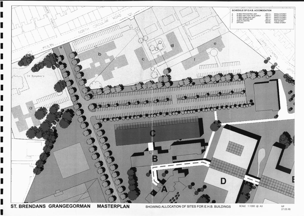
19 The Hospital Plan We are presently considering the future of St. Brendan's Hospital and its site, both in terms of service requirements in the EHB region and of future site requirements. The changing nature of psychiatric care and the need for community based facilities will in time make most of the St. Brendan's complex inoperable. Current policy envisages the use of open user-friendly community-centred units instead of traditional enclosed institutions. This will free most of the existing hospital site for other uses. We see the future requirements of St. Brendan's Hospital being adequately met on a smaller site within the existing complex. It is envisaged that in the longer term the only remaining services on the site will be: 1) 30 Bed Transitional Psychiatric Unit 2) 50 Bed Community Unit for the Elderly Mentally 111 3) 15 Bed Unit for the Homeless 4) 15 Bed Unit for Psychiatric Use (Secure) 5) Primary Care Unit (Health Centre) 6) Administration Offices The suggested location for these units is along the North Circular Road and Grangegorman Upper and are shown on Map 2 attached. 16
20 These new facilities alone will not of course serve the needs of patient and client requirements and will require other major developments around Dublin before the overall plan may be implemented. In this regard the plan is dependent on the provision of the following: A) New Acute Units as James Connolly Memorial Hospital, Blanchardstown and St. Vincent's Hospital, Elm Park. B) 3 Further 30 Bed Transitional Psychiatric Units in our Boards Catchment area. C) 2 Further 15 Bed (Secure) Units possibly at Dundrum and Portrane. D) New Occupational Therapy Unit for Day Services in Dublin 7 Area. In addition provision will have to be made off site for the Engineering base which may in the long-term be dispersed around several location. Catering facilities and library research facilities can remain on the site in the short term by arrangement with the D.I.T. 17
21 St. Brendan's Hospital and the Dublin Institute of Technology The present hospital of St. Brendan's gives little to the City and deliberately excludes connection with its neighbourhood. With the exception of the playing pitches in the West site it is, for obvious security reasons, inaccessible to the public. Its visual inaccessibility is maintained by the presence of high stone walls around its street boundaries, although this is partly reduced between its two entrances on Grangegorman Upper by the use of an open-railed fence on a stone plinth. The St. Brendan's Hospital precinct is essentially a 19 th century creation and its public image is a reflection of the values and concerns of that era. The reorganisation of the hospital provides an unprecedented opportunity for opening up the site and reintroducing it into its urban context. It also provides the possibility of reinterpretating the standard view of a psychiatric hospital. The following is an extract of a report submitted to Dublin Institute of Technology by Consultant Architects Scott Tallon Walker: 18
22 "This is an interim report on the Masterplanning for the Dublin Institute of Technology. The study is intended to advise on the future needs of the Institute into the early years of the next century, including an assessment of current accommodation and the re-structuring of the Institute on a faculty basis. A building atlas is in the course of preparation to assess existing accommodation, its suitability and the efficiency of its planning and use. Initial evaluation of current accommodation, its deficiencies in space, location and suitability for teaching purposes and an assessment of future expansion has made it clear that the accommodation problems of the D.I.T. can not be solved without the acquisition of additional lands. CURRENT ACCOMMODATION Current accommodation is located in some twenty two different locations ranging from Mountjoy Square in the North City to Rathmines in the South City. Total current accommodation is approximately 99,810sq.m. of which 15,550sq.m. is in unsuitable rented accommodation. The existing sites are very restricted and have a total site are of about 10 acres. 19
23 CURRENT NUMBERS In 1994 /95 the D.I.T. student body comprises 9469 Whole Time Students 8553 Part Time Students 4210 Apprentices Total Student Body = 22,412 Estimated equivalent whole time = 13,500 E.W.T. Staff Numbers Approximately 1,000 wholetime academic 1,000 part time academics 500 Administrative and Technical SPACE DEFICIENCIES On current number of 13,500 E.W.T. and applying approximate norm, of 10.5m" per student, Current accommodation should be: 13,500x10.5 = 141,750m 2 Current Accommodation is 99,81 Om 2 Therefore current space deficiency is 41,940m 2 Needed to replace rented accommodation 15,550m 2 Therefore new building required to make-up Current shortfall 57,490m 2
24 Much of the existing accommodation is inconveniently dispersed, inappropriate for function, inefficient and uneconomical. Specialist facilities including Library / Information Technology, student services and social facilities are required. FUTURE SPACE REQUIREMENTS Projected student numbers in 2005 Total required 16,500 x 10.5 Less existing space 16,500 E.W.T. 173,250 sq.m. 99,630 Add to replace rented space 73,620 sq.m. 15,550 89,170 sq.m. EXISTING MAJOR PROBLEMS Because of the scale of investment (one estimate c. 100m) in Bolton Street, Kevin Street and Aungier Street as purpose made Colleges with excellent accommodation, these centres would be retained in any Masterplanning exercise. A preliminary study has been made to see how accommodation can be maximised at these centres and possible extension areas are as follows: Bolton Street Kevin Street Aungier Street 3,000sq.m. (adjoining property would have to be acquired). 5,000sq.m. (CDVEC site in Pleasant Street has to be transferred). 10,000sq.m. Making a Total of 18,000sq.m. 21
25 Assuming that 18,000sq.m. can be extended to these Colleges it leaves an area of 71,170sq.m. to be provided at a new location. If the hotel and catering management would eventually be moved to a new location, an area of 90,670sq.m. should be provided for in the Masterplarming exercise to remedy current deficiencies and allow for short term expansion as well as to consolidate dispersed accommodation, to withdraw from leased accommodation and to provide some scope for the future development of the Institute. Studies have been made of every available site in proximity to the major Colleges. No suitable sites were identified that would meet all the requirement for space accommodation, economy of shared accommodation, sports facilities and student accommodation. The acquisition of sites adjoining the Kevin Street / Aungier Street complex, such as the Meath the Adelaide Hospital sites would continue the disjointed development of the Institute. All our studies have indicated that the only suitable site that can meet all the future needs is located in the North West Inner-City on the properties at present occupied by St. Brendan's Hospital. The site is in two lots on each side of Grangegorman Road. The main Hospital site is 55 acres. Approximately half of this area is zoned "to preserve recreational amenity including open space" and half is zoned "to protect and improve residential amenities". 22
26 The smaller site to the east of Grangegorman Road is 18 acres in area and is zoned "to protect the existing architectural and civic design character, to allow for limited expansion consistent with the conservation objective and to allow primarily residential and compatible office uses and institutional uses". Some existing structures are listed under List 2 of the Dublin Corporation Development Plan. This site adjoins the Broadstone site currently occupied by Bus Eireann as a bus depot and maintenance centre. The main Terminal Building, the front portion of which is listed, houses workshops and administrative offices. The northern portion of the site is not in use and most building are currently vacant. CLE. have indicated that they would be interested in any proposals for acquisition of portion of this site with the acquisition of the Grangegorman site could directly link the main property investment of the D.I.T. at Bolton Street and Linenhall Place directly to the Grangegorman site. Any study of the light transit rail system planned for 1999 would indicate that it cannot function without a maintenance centre on the rail line and Broadstone would appear to be the obvious centre for this. It has been indicated to us that the two lines most likely to be addressed first in the light transit proposals would go from Dorset Street, via O'Connell Street, Dame Street, St. Georges Street to Charlemont Street with a further link from Heuston Station via Benburb Street, Abbey Street to O'Connell Street. 23
27 A very short extra run would link the Dorset Street line through Dominick Street into Broadstone providing a direct connection by light rail for the Grangegorman site, Bolton Street, Cathal Brugha Street, Kevin Street and Aungier Street, thereby linking all the Colleges of D.I.T. which will be retained. CLE. would be very supportive of this idea as it provides them with a direct access to servicing accommodation and a direct connection to the existing line to the north west section of the City through Cabra to the Liffey junction. This reinforces the case for the suitability of the Grangegorman site for the D.I.T. The site would also provide accommodation for sports facilities in the area zoned as open space, it can accommodate all the future needs in space provisions and being directly linked to the major property at Bolton Street can provide the unifying element required by the Institute. It is located in the North West Inner City, an area in great need of rejuvenation in our City. The proposed site is also very much linked to the Smithfield area of Dublin, a priority area with Dublin Corporation for redevelopment and an area that could be developed by private enterprise to provide student accommodation and leisure facilities. The site of 18 acres to the east of Grangegorman Road is virtually unoccupied at present and the entire site could be available within five years. 24
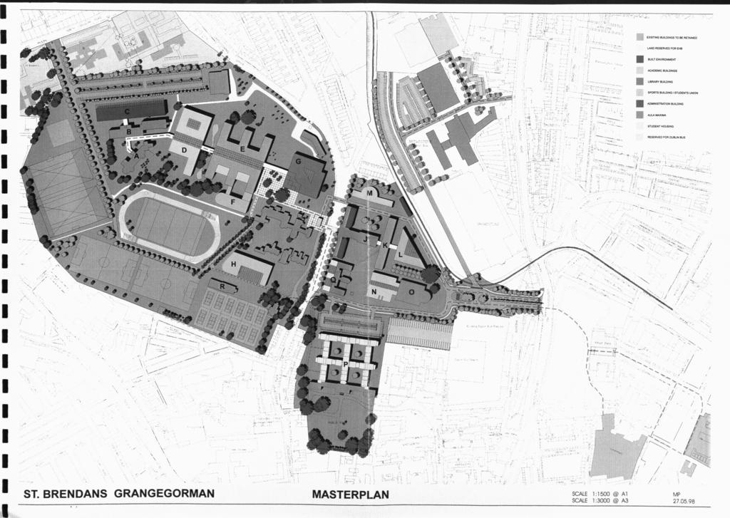
28 Existing buildings on the site have to be assessed for their suitability for D.I.T. uses, but we are satisfied that some of the existing listed buildings are very suited to refurbishment for immediate use, including the provision of a D.I.T. Headquarters. Preliminary master planning studies have been made to test the suitability of the Grangegorman site to meet the future needs of the D.I.T. We have included with this preliminary report some of these studies showing how the building volume can be accommodated and how the full needs for both buildings and sport facilities can be readily provided within the existing zoning and objectives of Dublin Corporation. The detail of the study will be the subject of a later report when the condition and suitability of existing accommodation has been properly assessed. 25
29
30 PART 3 Recommendations and Masterplan 26
31 RECOMMENDATIONS: In order to develop and carry out our policy there is no doubt that St. Brendan's Hospitals as we know it today will eventually reduce to only provide the services suggested earlier in this report. Regarding its future use we have studied carefully the proposals from DIT and consulted widely with Architects Scott Tallon Walker, Arthur Gibney & Partners and with the Planning Department and Senior Management of Dublin Corporation. All are of the opinion that St. Brendan's can provide a University Campus setting and offers an excellent planning solution for the long-term future of St. Brendan's Hospital. From a planning viewpoint it is regarded as an exceptional opportunity to protect an important Inner City area for future generations in the Capital City. However, I am conscious that in pursuing this proposal we must take careful account of our Board" requirements and of course that any disposal that may ensue to D.I.T. represents the market value of the complex. This draft proposal and any changes therefrom will of course take a considerable time scale to implement. In this regard it is likely to take up to 5 years on a phased basis. It is my recommendation that our Board agrees in principle to formalising arrangements with the D.I.T. subject to a further report detailing the phasing of such arrangements and the price to be obtained. 27
32
2bPlanning Scheme. Appendix. Conservation - Removal of Structures. Grangegorman
 Appendix 2bPlanning Scheme Grangegorman Conservation - Removal of Structures Innovative Urban Quarter Contemporary Healthcare Facilities Modern Education Hub Accessible Public Spaces Appendix 2b: Purpose
Grangegorman A New Campus for a New University
 Grangegorman A New Campus for a New University Dr Louis Gunnigan Campus Planning Team Dublin Institute of Technology Grangegorman A Project that is Changing a City Background Grangegorman 200 year+ history
heuston gateway: sections heuston gateway: regeneration strategy and development framework plan
 B B1 A B1 B C A heuston gateway: sections B B1 C 117 4.3.3 Zoning The station is the central hub of the area and this function must be preserved and developed. However large areas of the Heuston Station
Developing a New Urban Quarter at Grangegorman, Dublin: The Role of Planning in its Successful Delivery
 Developing a New Urban Quarter at Grangegorman, Dublin. Developing a New Urban Quarter at Grangegorman, Dublin: The Role of Planning in its Successful Delivery Terry Prendergast BSc, MPhil, MSc, MIPI Principal
Lancaster Conservation Area Appraisal. Character Area 8. Cathedral
 Lancaster Conservation Area Appraisal Character Area 8. Cathedral March 2013 118 3.8 Character Area 8. Cathedral 3.8.1. Definition of Special Interest "This character area is distinctive for the fine group
7.0 NATIONAL WINE CENTRE
 91 7.0 NATIONAL WINE CENTRE 7.1 Description of Campus The National Wine Centre Campus is located on the south eastern corner of the Botanic Gardens. It occupies a site originally used for the Lunatic Asylum
Housing Land Initiative. Feasibility Study. Update
 Report to the Housing & Community Strategic Policy Committee Housing Land Initiative Feasibility Study Update September 2016 Oscar Traynor Road Site Site Description Dublin City Council owns a 17.014 ha
stakeholders Zoning Conservation Connections
 4.7.1 Zoning The Phoenix Park site is identified as an important gateway site to the city. The site should be developed as a landmark public building with office or cultural use. The present zoning, Z9,
WELLINGTON HOSPITAL DESIGN GUIDE TABLE OF CONTENTS
 WELLINGTON HOSPITAL DESIGN GUIDE TABLE OF CONTENTS 1.0 Introduction Page 2 The Place of Wellington Hospital 2 The Future of the Hospital 2 2.0 The Intention of the Design Guide 3 3.0 Analysis 4 General
NHS DUMFRIES & GALLOWAY - NITHBANK
 NHS DUMFRIES & GALLOWAY - NITHBANK Feasibility Options 19 March 2018 nithbank - site appraisal Site Analysis Set high on a terrace above a formal garden and the main road. This position and setting is
UNIVERSITY TOWN NEIGHBOURHOODS 5.5 HOUSING MELBOURNE CAMPUS MASTER PLAN 2014
 5.5 169 EXISTING CONDITIONS & VISION NEIGHBOURHOOD VISION The provision of on-campus housing into the future will continue to be an important element of the La Trobe University experience. A long-term
development framework plan
 3.2.1.1 Phoenix Park to Royal Hospital Kilmainham The Phoenix Park and Royal Hospital Kilmainham Park have been separated since the construction of the Heuston Station in the mid 1800s. Consequently both
GREAT WESTERN SQUARE & ENVIRONS
 GREAT WESTERN SQUARE & ENVIRONS Draft Architectural Conservation Area Report Character Appraisal and Policy Framework 20 1 Architectural Conservation Area Report: GREAT WESTERN SQUARE & ENVIRONS Draft
6.1 University Projects
 The Campus Master Plan provides a framework and guidelines for uottawa s evolution over the next 20 or more years. This chapter provides direction for the near term, identifying current and proposed initiatives
Lincoln Townscape Assessment. Boultham Park Inherited Character Area Statement
 Lincoln Townscape Assessment Boultham Park Inherited Character Area Statement January 2008 Page 2 of 12 Table of Contents Page Overview 2 Historical Development 2 Urban form 3 Views 5 Condition of Buildings
ELMVALE ACRES SHOPPING CENTRE MASTER PLAN
 ELMVALE ACRES SHOPPING CENTRE MASTER PLAN Contents 1.0 INTRODUCTION... 2 2.0 LOCATION... 2 3.0 EXISTING CONTEXT... 2 4.0 VISION & GUIDING PRINCIPLES... 2 5.0 LAND USE AND BUILT FORM... 4 5.1 St. Laurent
GREENFORD HALL & ADJOINING LAND
 GREENFORD HALL & ADJOINING LAND CONTENTS 1. Introduction 1. Introduction 2. Urban Context 2.1 The Site and Surroundings 2.2 Urban Context Map 2.3 Access and Movement 3. Planning Context 3.1 Planning History
4.00 STAKEHOLDERS. urbanprojects
 4.00 STAKEHOLDERS 94 heuston gateway: regeneration strategy and development framework plan 95 The Heuston Gateway presents one of the greatest concentrations of brown field development sites located adjacent
Warren Farm, Ampthill
 1 Welcome The developers of the Warren Farm site, Bloor Homes and Connolly Homes, are holding this exhibition on the emerging Design Codes for the development prior to their formal submission to Central
17. Coolaney-Rockfield Mini-Plan
 County Development Plan 2017-2023 Consolidated Draft + Adopted Amendments - August 2017 17. Coolaney-Rockfield Mini-Plan Village profile Coolaney is located approximately 23 km to the south-west of Sligo
BORRISOKANE SETTLEMENT PLAN
 BORRISOKANE SETTLEMENT PLAN 1.0 General Introduction and Development Context Location Borrisokane is located 15km north of Nenagh on the N52. While the town is primarily residential, it acts as a market
Page 1 of 19 URBAN DESIGN FRAMEWORK FOR BOLTON STREET WATERFORD
 Page 1 of 19 URBAN DESIGN FRAMEWORK FOR BOLTON STREET WATERFORD 1.0 Introduction: The relocation of the City Council stores and depot from Bolton Street creates an exciting opportunity for development
Part D. College Avenue Campus PAGE 121 UNIVERSITY OF REGINA / CAMPUS MASTER PLAN 2011
 Part D College Avenue Campus UNIVERSITY OF REGINA / CAMPUS MASTER PLAN 2011 PAGE 121 PAGE 122 PREPARED BY / DIALOG Figure D-1. A view of the College Building at the College Avenue Campus in winter 11.0
Memo. B R A Y H e r i t a g e
 6 1 3. 5 4 2. 3 3 9 3 6 1 3. 5 4 9. 6 2 3 1 c a r l @ b r a y h e r i t a g e. c o m Memo To: Jennifer Murray, Windmill Development Corporation From: Carl Bray, Bray Heritage Date: Monday, June 5, 2017
28. Coolaney-Rockfield Mini-Plan
 28. Coolaney-Rockfield Mini-Plan 28. Coolaney-Rockfield Mini-Plan Community facilities Community facilities in Coolaney-Rockfield consist of a primary school, crèche, community centre, sports field and
DUBLIN DOCKLANDS MASTER PLAN AND RELATIONSHIP WITH OTHER PLANS
 .1 National Policy and Programmes.1.1 Sustainable Development A Strategy for Ireland, 1997.1.2 National Climate Change Strategy, 2007-2012.1. National Development Plan 2007-201.1.4 National Spatial Strategy,
COURTHOUSE CAMPUS BARNSLEY Executive Summary March 2010
 COURTHOUSE CAMPUS BARNSLEY Executive Summary March 2010 Estell Warren Cartwright Pickard Buro Happold King Sturge BWA Barnsley Metropolitan Borough Council introduction Courthouse Campus is the last major
SUBJECT: PREDEVELOPMENT PLAN REVIEW OF PROJECT LOCATED AT 2632 EAST WASHINGTON BOULEVARD ('ST. LUKE MEDICAL CENTER')
") TO: FROM: Honorable Mayor and City Council Planning & Community Development Department SUBJECT: PREDEVELOPMENT PLAN REVIEW OF PROJECT LOCATED AT 2632 EAST WASHINGTON BOULEVARD ('ST. LUKE MEDICAL CENTER')
TO: FROM: Honorable Mayor and City Council Planning & Community Development Department SUBJECT: PREDEVELOPMENT PLAN REVIEW OF PROJECT LOCATED AT 2632 EAST WASHINGTON BOULEVARD ('ST. LUKE MEDICAL CENTER')
ALTERNATIVE PROPOSAL FOR TRI LOCATED NATIONAL PAEDIATRIC HOSPITAL BY 2016 ON A 20.5 ACRE (8.3 HECTARE) SITE
 SITE") ALTERNATIVE PROPOSAL FOR TRI LOCATED NATIONAL PAEDIATRIC HOSPITAL BY 2016 ON A 20.5 ACRE (8.3 HECTARE) SITE EXECUTIVE SUMMARY This is a viable and achievable proposal to realise an iconic tri located National
ALTERNATIVE PROPOSAL FOR TRI LOCATED NATIONAL PAEDIATRIC HOSPITAL BY 2016 ON A 20.5 ACRE (8.3 HECTARE) SITE EXECUTIVE SUMMARY This is a viable and achievable proposal to realise an iconic tri located National
WELCOME TO THE NEW WILTON PARK
 WELCOME TO THE NEW WILTON PARK VISION HISTORY OF WILTON PARK TOWARDS A PLANNING APPLICATION Our objective is to create a truly outstanding environment at Wilton Park. At the heart of our proposals is a
Sheffield Victoria Station Development Prospectus January 2014
 6 Billion extra GVA growth for Sheffield City Region s economy Sheffield Victoria Station Development Prospectus January 2014 Document produced by Sheffield City Council Introduction The construction of
ARCHITECTURAL SERVICES DEPARTMENT
 ARCHITECTURAL SERVICES DEPARTMENT 25th August 2016: COUNTY ARCHITECT S REPORT FOR PART 8 DISPLAY / CONSULTATION Project Details - Part 8 Application DEVELOPMENT OF A NEW PUBLIC LIBRARY ON CASTLETYMON ROAD
13 THORNHILL YONGE STREET STUDY IMPLEMENTATION CITY OF VAUGHAN OPA 669 AND TOWN OF MARKHAM OPA 154
 13 THORNHILL YONGE STREET STUDY IMPLEMENTATION CITY OF VAUGHAN OPA 669 AND TOWN OF MARKHAM OPA 154 The Planning and Economic Development Committee recommends the adoption of the recommendations contained
Colchester Northern Gateway Master Plan Vision Review Draft. July 2016
 Colchester Northern Gateway Master Plan Vision Review Draft July 2016 Contents Introduction 4 Context 8 Purpose of the Report 8 Strategic Position 9 Overview of the Process 11 2012 Master Plan Vision 12
BLETCHLEY PARK AREA - DEVELOPMENT FRAMEWORK
 ANNEX A To Item 9 REVISED TEXT: additions shown bold and underlined, deletions in (brackets and in italics). BLETCHLEY PARK AREA - DEVELOPMENT FRAMEWORK This framework sets out the key objectives and requirements
Welcome to our exhibition
 Welcome to our exhibition The Homes & Communities Agency (HCA) welcomes you to this public exhibition explaining our proposals for the redevelopment of the former Lea Castle Hospital site. About the Homes
WINDSOR GLEN DESIGN GUIDELINES
 WINDSOR GLEN DESIGN GUIDELINES Adopted by Council, 2006 WINDSOR GLEN REDEVELOPMENT DESIGN GUIDELINES August 2006 1.0 Master Plan Organization For this area of the Coquitlam Town Centre, a mix of high,
Horwood Map of London, Westminster & Southwark First edition
 Barratt London is developing plans in tandem with Southwark Council and TfL to transform the southern end of Blackfriars Road. The residential-led, mixed-use scheme will deliver new private and affordable
BLACKHEATH SQUASH CLUB Blackheath Sports Club, Rectory Field, Charlton Road, London, SE7 7EY. Planning, Design and Access Statement
 Planning, Design and Access Statement Revised: 28 th Jan 2016 Peter Pendleton & Associates Ltd Introduction Planning permission will be sought for a refurbishment of existing courts and extension to provide
I539. Smales 2 Precinct
 I539. Smales 2 Precinct I539.1. Precinct Description The Smales 2 Precinct applies to a 4.8 hectare block of land located on the southern side of Northcote Road and fronting Lake Pupuke, Takapuna. The
DESIGN AND ACCESS STATEMENT NEW TALYBONT HALLS, CARDIFF UNIVERSITY JULY 2018
 DESIGN AND ACCESS STATEMENT NEW TALYBONT HALLS, CARDIFF UNIVERSITY JULY 2018 1 FILE NTHCU-STL-XX-XX-RP-A-9075-RP013 PROJECT New Talybont Halls, Cardiff University CLIENT Cardiff University STRIDE TREGLOWN
Introduction. Welcome to this consultation regarding the draft redevelopment proposals for the former CeramTec factory on Sidmouth Road, Colyton.
 Introduction Welcome to this consultation regarding the draft redevelopment proposals for the former CeramTec factory on Sidmouth Road, Colyton. We are currently considering options for the mixed-use redevelopment
I331. St John s Theological College Precinct
 I331. St John s Theological College Precinct I331.1. Precinct Description The precinct contains the existing St John s Theological College which is a residential college for the Anglican Church in New
3.3. Urban Structure Defining a New Hierarchy of Routes and Spaces >Images
 Section 3.0 I The Masterplan Framework 18 >Images Examples of high quality routes and spaces 3.3. Urban Structure The success of any masterplan lies in a clear definition of the future urban structure
EVALUATION OF MASTER PLAN ALTERNATIVES
 7 The Environmental Report is required to identify, describe and evaluate reasonable alternatives, taking into account the objectives and geographical scope of the Master Plan 2008. Three plan alternatives
5. Bankside and The Borough 5.1. Bankside and The Borough Area Vision
 5. 5.1. Area Vision 5.1.1. are: A globally significant central London business district which is home to international business headquarters; At the heart of the commercial and cultural life of the capital
1.0 Purpose of a Secondary Plan for the Masonville Transit Village
 Report to Planning and Environment Committee To: Chair and Members Planning & Environment Committee From: John M. Fleming Managing Director, Planning and City Planner Subject: Masonville Transit Village
01 Welcome! About Ontario Shores
 01 Welcome! Thank you for participating in the Master Planning Open House. Ontario Shores Centre for Mental Health Sciences is in the process of preparing a Master Program and Master Plan for submission
development framework
 dublin city council: heuston gateway regeneration strategy substudy document: guinness udv lands Guinness UDV Lands development framework Dublin City Council Steering Group: Sean Carey Ast. City manager
Chapter 2: OUTLINE PLANNING APPLICATION PROPOSALS. A New Garden Neighbourhood Matford Barton 17
 Chapter 2: OUTLINE PLANNING APPLICATION PROPOSALS A New Garden Neighbourhood Matford Barton 17 2.1. SUMMARY AND STATUS OF THE PROPOSALS 2.1.1. The parameter plans and associated wording in this chapter
ROYAL MINT COURT SECURES PLANNING CONSENT FOR 600,000 SQ. FT. COMMERCIAL SCHEME FOR OVER 6,000 LONDON WORKERS
 PAGE 1 OF 5 ROYAL MINT COURT SECURES PLANNING CONSENT FOR 600,000 SQ. FT. COMMERCIAL SCHEME FOR OVER 6,000 LONDON WORKERS JULY 2016 Approved plans will transform the historic 5.2 acre central London site
Physical Structure. This historic image from 1882 emphasizes the dramatic topography that distinguishes Cornell s setting at the top of East Hill.
 Physical Structure The natural, agrarian and urban setting for Cornell s campus is a precious resource to protect and enhance. It has also shaped the physical structure of the campus. Buildings, roads
public spaces and accociated development
 4.0 Public Spaces and Associated Development The development must address appropriately the public spaces immediately adjoining it: the River Walkway and Parkgate Street. The development is also highly
MDP -- District Plan Webform Submissions Submission Details
 MDP -- District Plan Webform Submissions Submission Details Completed Time Represented By Who Title Age Bracket 03/31/2017-16:44 I am submitting my Mr 40-49 organisation's submission First Name Last Name
Sunday's Well Proposed Architectural Conservation Area
 1 Sunday's Well Proposed Architectural Conservation Area D A E C B F Old City Gaol Saint Vincent s RC Church Saint Albert s Former Good Shepherd Convent Boundary of Area Sunday's Well is an area located
30. Riverstown Mini-Plan
 County Development Plan 2017-2023 Consolidated Draft + Adopted Amendments August 2017 Volume 2, Chapter 30 Riverstown Mini-Plan 30. Riverstown Mini-Plan Village profile Riverstown is located approximately
10. East Dulwich East Dulwich Area Vision
 10. 10.1. Area Vision 10.1.1. is: A predominantly residential area characterised by mostly medium density housing, including many family homes. Many parts of have retained historic character and it includes
An Bord Pleanála. Inspector s Report. Grangegorman Planning Scheme. Location: St. Brendan s Hospital Grounds, Upper Grangegorman, Dublin 7.
 An Bord Pleanála Inspector s Report Board Reference: 29Z.ZD2005 Planning Authority: Dublin City Council Development Agency: Grangegorman Development Agency Proposal: Grangegorman Planning Scheme Location:
L 2-1 HERITAGE REPORT: REASONS FOR HERITAGE DESIGNATION. Cheyne Family Cemetery. Main Street South
 L 2-1 HERITAGE REPORT: REASONS FOR HERITAGE DESIGNATION Cheyne Family Cemetery Main Street South October 2013 L 2-2 PROFILE OF SUBJECT PROPERTY: Municipal Address Main Street South (Lot 14, Con 1, EHS)
PLANNING RATIONALE FOR THE PROPOSED RIVERSIDE SOUTH ELEMENTARY SCHOOL 715 BRIAN GOOD AVENUE, OTTAWA, ON
 PLANNING RATIONALE FOR THE PROPOSED RIVERSIDE SOUTH ELEMENTARY SCHOOL 715 BRIAN GOOD AVENUE, OTTAWA, ON Conseil des écoles publiques de l'est de l'ontario (CEPEO) French Public School Board TABLE OF CONTENTS
Gas Works Site Land-Use Study
 City of New Westminster Background Context 2 Neighbourhood Context 3 Program Elements 4 Proposed Site Planning Approach 5 Design Rationale 10 Design Elements 11 Phasing 21 C o n t e n t s b a c k g r o
3.0 Area-Wide Strategies 30
 3.0 Area-Wide Strategies 30 3.6 Tourism Strategy This section of the plan aims to develop and improve the tourism potential of the area. Strategic Context The City Plan outlines the potential of Cork to
GUIDELINES TORONTO GENERAL HOSPITAL LOCATION. INTRODUCTION Existing College Wing Buildings and Site Plan - Figure 1A and Figure 1B.
 GENERAL HOSPITAL Development in the south-east quandrant of University Avenue and College Street will be consistent with the following urban design guidelines. LOCATION Lands owned by the Toronto General
Ordnance Street 110 Plan OS Lot 413 B202; parts of Lot 412 and portion of Lot 413
 Ordnance Street 110 Plan OS Lot 413 B202; parts of Lot 412 and portion of Lot 413 110 Ordnance Street has cultural heritage value under 3 categories Physical built in 1886, it is an example of late 19
Derry City and Strabane District Council Planning Committee Report
 Derry City and Strabane District Council Planning Committee Report COMMITTEE DATE: 23 rd March 2016 APPLICATION No: APPLICATION TYPE: PROPOSAL: LOCATION: APPLICANT: LA11/2015/0395/F Residential Development
MOUNT AVENUE MASTERPLAN WORKING DRAFT NOVEMBER 2006
 MOUNT AVENUE MASTERPLAN WORKING DRAFT NOVEMBER 2006 1 1. OVERALL MASTERPLAN IDENTITY: Dun Dealgan motte and bailey The Dun Dealgan motte and bailey, a national monument, is located to the north east of
YONGE STEELES CORRIDOR SECONDARY PLAN. Young + Wright / IBI Group Architects Dillon Consulting Ltd. GHK International (Canada) Ltd.
 Ltd.") PART A: PREAMBLE 1.0 PURPOSE The purpose of this Secondary Plan is to provide a development framework for intensification of the Yonge/ Steeles corridor including the north side of Steeles Avenue West
PART A: PREAMBLE 1.0 PURPOSE The purpose of this Secondary Plan is to provide a development framework for intensification of the Yonge/ Steeles corridor including the north side of Steeles Avenue West
Master Plan. Centre for Addiction and Mental Health. Executive Summary. for the Queen Street West Toronto, Ontario
 Master Plan Executive Summary for the Centre for Addiction and Mental Health 1001 Queen Street West Toronto, Ontario August 2002 INTRODUCTION The redevelopment of 1001 Queen Street West in Toronto provides
URBAN DESIGN BRIEF 305, 309, & 315 SOUTHDALE ROAD WEST LONDON ONTARIO
 URBAN DESIGN BRIEF 305, 309, & 315 SOUTHDALE ROAD WEST LONDON ONTARIO CARVEST PROPERTIES LTD. December 2013 Section 1 - Land Use Planning Context 1.1 Subject Lands The subject lands are located immediately
6. Bermondsey 6.1. Bermondsey Area Vision
 6. 6.1. Area Vision 6.1.1. is: An inner-london neighbourhood characterised by modest worker ho associated with the historic Rotherhithe docks and local manufacturing industries such as biscuits, jam, vinegar
Doncaster Christ Church Conservation Area
 Doncaster Christ Church Conservation Area Review June 2017 www.doncaster.gov.uk/conservationareas Doncaster Christ Church Conservation Area Review Since the appraisal was finalised in February 2011, the
SECTION ONE: INTRODUCTION. introduction
 introduction 1 INTRODUCTION Since it was first established in 1843 as a trading post for the Hudson s Bay Company, Victoria has evolved into a Provincial capital city that is recognized across Canada and
Seneca Meadows. Block 4 Locate office, technology, and medical development adjacent to I Screen views of garage structures from I-270.
 Seneca Meadows Seneca Meadows has an industrial park in its southern end and a mixed-use employment area planned for the north end. The district benefits from extensive I-270 visibility, stream valley
Persimmon Homes Thames Valley Date received: 2 nd April week date(major): 2 nd July 2014 Ward: Nascot
: 2 nd July 2014 Ward: Nascot") PART A Report of: DEVELOPMENT MANAGEMENT SECTION HEAD Date of Committee: 26 th June 2014 Site address: Rounton, 28, Nascot Wood Road Reference Number: 14/00497/REM Description of Development: Reserved
PART A Report of: DEVELOPMENT MANAGEMENT SECTION HEAD Date of Committee: 26 th June 2014 Site address: Rounton, 28, Nascot Wood Road Reference Number: 14/00497/REM Description of Development: Reserved
Former Keighley College Buildings, North Street
 Introduction The Vision To create a high quality, mixed-use destination that will lead to the successful redevelopment of the site and contribute to the wider regeneration of the town centre The Opportunity
[PLANNING RATIONALE] For Site Plan Control and Lifting of Holding Zone By-Law 101 Champagne Avenue. May 23, 2014
![[PLANNING RATIONALE] For Site Plan Control and Lifting of Holding Zone By-Law 101 Champagne Avenue. May 23, 2014](/thumbs/75/71599615.jpg "[PLANNING RATIONALE] For Site Plan Control and Lifting of Holding Zone By-Law 101 Champagne Avenue. May 23, 2014") [PLANNING RATIONALE] For Site Plan Control and Lifting of Holding Zone By-Law 101 Champagne Avenue May 23, 2014 Contents 1.0 Introduction... 2 2.0 Site Context... 2 2.1 Adjacent Uses... 2 Figure 1: Site
[PLANNING RATIONALE] For Site Plan Control and Lifting of Holding Zone By-Law 101 Champagne Avenue May 23, 2014 Contents 1.0 Introduction... 2 2.0 Site Context... 2 2.1 Adjacent Uses... 2 Figure 1: Site
Commenting on Planning Applications: MHPRA Policy
 Commenting on Planning Applications: MHPRA Policy millhillparkacton.org Our Area The Mill Hill Park Residents Association covers the Mill Hill Park Conservation Area in Acton, W3. Objectives We aim to
Welcome to our exhibition
 Welcome to our exhibition housing development A46 Wildmoor Alcester Road Canal Quarter A422 Town Centre housing development Warwickshire-based IM Properties, one of the UK s largest privately owned property
Bus Rapid Transit Backgrounder. December 2016
 Bus Rapid Transit Backgrounder December 2016 Background The City of London is completing the second stage of Shift, its public transit planning exercise. Shift, focuses on rapid transit, along with vehicular
Status Update (2006 vs. Now) Citizen s Advisory Committee February Plan for Prosperity
 Citizen s Advisory Committee February Plan for Prosperity") Status Update (2006 vs. Now) Citizen s Advisory Committee February 2018 Plan for Prosperity 2000 2017 2000 2017 Gardnerville Population 6,000 5,760 5746 5,500 5,000 5,067 5,550 5,165 5,394 5,412 5,250
Status Update (2006 vs. Now) Citizen s Advisory Committee February 2018 Plan for Prosperity 2000 2017 2000 2017 Gardnerville Population 6,000 5,760 5746 5,500 5,000 5,067 5,550 5,165 5,394 5,412 5,250
Craigmillar, Edinburgh, UK
 I m p r o v i n g t h e q u a l i t y o f l i f e i n L a r g e U r b a n D i s t r e s s e d A r e a s Craigmillar, Edinburgh, UK E-Compendium: Good Practice Case Studies LUDA is a research project of
UDF PLANS AND GUIDELINES
 UDF PLANS AND GUIDELINES 5 Land Use Land Use Development Plan Plan no. 3 Land Use Development Mixed Use Retail / Leisure Residential Civic and Institutional Proposed Zoning Table Development Edges Plan
13. London Bridge London Bridge Area Vision
 13. 13.1. Area Vision 13.1.1. is: A globally significant central London business district which is home to international business headquarters; Internationally renowned for its prominent riverfront location
SITE ANALYSIS CALVARY HOSPITAL NORTH ADELAIDE LARGE INSTITUTIONS AND COLLEGES DPA CALVARY HOSPITAL
 SITE ANALYSIS Located at: 81-100 Strangways Terrace 55-79 Barnard Street 2-34 Hill Street 312-320 Ward Street HISTORY The Calvary Hospital was established in 1900 and is one of Adelaide's oldest hospitals.
2.0 Strategic Context 4
 2.0 Strategic Context 4 2.1 The Area Action Plan is a non-statutory plan, which forms a corporate policy document, expressing particular issues and areas of concern while also providing a vision for the
NORTH CIRCULAR ROAD - REGENERATION IN ACTION
 NORTH CIRCULAR ROAD - REGENERATION IN ACTION Notting Hill Housing is a social enterprise which has been at the forefront of vibrant urban regeneration since 1963. Notting Hill has over 25,000 homes across
THE GEORGE WASHINGTON UNIVERSITY MOUNT VERNON CAMPUS
 THE GEORGE WASHINGTON UNIVERSITY MOUNT VERNON CAMPUS CAMPUS PLAN AMENDMENT AND FURTHER PROCESSING APPLICATION: PRE-HEARING SUBMISSION PELHAM REPLACEMENT PROJECT FILED WITH THE ZONING COMMISSION OF THE
Public Consultation. Land at Monks Farm, North Grove. Welcome
 Welcome Welcome to our public exhibition for development on Land at Monks Farm, orth Grove. Gallagher Estates and Gleeson Strategic Land are preparing an outline planning application for new homes, open
TO: Mayor & Council DATE: April 12, The Planning and Development Department and the Engineering Department recommend that Council:
 CORPORATE REPORT NO: R080 COUNCIL DATE: April 12, 2010 REGULAR COUNCIL TO: Mayor & Council DATE: April 12, 2010 FROM: SUBJECT: General Manager, Planning and Development General Manager, Engineering Neighbourhood
Mr & Mrs Connolly per Pump House Designs Pump House Yard The Green SEDLESCOMBE, East Sussex. TN33 0QA
 AGENDA ITEM NO: 5 (c) Report to: PLANNING COMMITTEE Date: 03 June 2015 Report from: Head of Housing and Planning Services Application Address: Proposal: Application No: Recommendation: Ward: File No: Applicant:
Oscar Traynor Road Land Initiative Project
 Oscar Traynor Road Land Initiative Project Page 1 INTRODUCTION This report has been prepared as a follow up document to the Housing Land Initiative Feasibility Study presented to the joint Housing and
75-89 Wallis Road & 59 Berkshire Road, Hackney Wick, London, E9 5LN
 East London Mixed-Use Development Opportunity CGI of Proposed Scheme Summary A mixed-use development opportunity located in Hackney Wick within the jurisdiction of the London Legacy Development Corporation.
Land Use Amendment in Southwood (Ward 11) at and Elbow Drive SW, LOC
 at and Elbow Drive SW, LOC") 2018 November 15 Page 1 of 10 EXECUTIVE SUMMARY This land use amendment application was submitted by Rick Balbi Architect on 2017 August 31 on behalf of Sable Developments Ltd, and with authorization from
2018 November 15 Page 1 of 10 EXECUTIVE SUMMARY This land use amendment application was submitted by Rick Balbi Architect on 2017 August 31 on behalf of Sable Developments Ltd, and with authorization from
22.15 OUTDOOR ADVERTISING SIGNAGE POLICY
 22.15 OUTDOOR ADVERTISING SIGNAGE POLICY This policy applies to all land where a planning permit is required to construct or display a sign under the provisions of the Kingston Planning Scheme. 22.15-1
The Proposed Auckland Unitary Plan (notified 30 September 2013)
") 3 Business zones Introduction There are 10 business zones in the Unitary Plan: City Centre Metropolitan Centre Town Centre Local Centre Neighbourhood Centre Mixed Use General Business Business Park Light
3 Business zones Introduction There are 10 business zones in the Unitary Plan: City Centre Metropolitan Centre Town Centre Local Centre Neighbourhood Centre Mixed Use General Business Business Park Light
INTRODUCTION. Land West of Main Road, Stanton Harcourt THE SITE. Why is the Site Suitable for Development?
 0 INTRODUCTION THE SITE Application Boundary Gladman Developments Ltd has successfully invested in communities throughout the UK over the past 0 years, developing high quality and sustainable residential,
6 Site Framework Strategies
 6 Site Framework Strategies 6.1 Introduction Section 6 identifies a number of specific areas which are considered to be key sites within the Plan area and which may have potential for development / redevelopment.
Woodbrook - Shanganagh
 Section 4: Key Sites Framework Strategy Woodbrook - Shanganagh Local Area Plan 2017-2023 4. Site Framework Strategies The Master Plans shall have regard to the thematic objectives under the LAP Development
REPORT BACK BROADSHEET 3 May 2016
 Paddington Place REPORT BACK BROADSHEET May 06 Architects and planners should work with the community first and then thinking about developers profits second. - Quote from participant at Paddington Place
SCHEDULE 12 TO THE DESIGN AND DEVELOPMENT OVERLAY GLEN WAVERLEY ACTIVITY CENTRE STRUCTURE PLAN
 DD/MM/YY Proposed C120 SCHEDULE 12 TO THE DESIGN AND DEVELOPMENT OVERLAY Shown on the planning scheme map as DDO12. GLEN WAVERLEY ACTIVITY CENTRE STRUCTURE PLAN 1.0 Design objectives DD/MM/YY Proposed