Mt Baker Park Safe Access Project
|
|
|
- Lesley Chapman
- 6 years ago
- Views:
Transcription


1 Mt Baker Park Safe Access Project


2 PROJECT TEAM Greg funk, stairway inspector karen selander, project manager pam kliment, neighborhood planner Property Owner Development / Design Guidelines Project oversight Funding Agency Community Process, Guidelines Project oversight Property Owner Development / Design Guidelines Project oversight jill mckinstry, Co-chair Friends of Mt. Baker Safe Access Volunteer Public Outreach / Engagement Community Builder / Champion Grant Applicant susan kocik, co-chair Friends of Mt. Baker Safe Access Volunteer Public Outreach / Engagement Community Builder / Champion Grant Applicant NIC MORIN, PLA & PETER CROMWELL Team Coordination & Project Management Community Design Process Landscape Architecture Analysis, Design & Construction Drawings Fundraising Support Fiscal Sponsor
3 SUMMARY OF PROJECT GOALS 1. Identify Needs of the Community 2. Respect City Standards (Design, Construction, Maintenance) 3. Upgrade the Trail 4. Connect to History 5. Synthesize & Blend into a Compelling Design
4 PROJECT SCHEDULE & PROCESS MAY - Project Kick-off: Outreach, Background, Site Analysis JUNE - First Community Meeting: Identify community needs, Design Game/Brainstorm JULY/AUGUST - Synthesize into 2-3 Alternatives & Review with City/Steering Committee SEPTEMBER - Second Community Meeting: Review findings, Discuss Design Alternatives OCTOBER - Generate Preferred Alternative & Review with City/Steering Committee NOVEMBER - Third Community Meeting: Refine Preferred Alternative DECEMBER - Complete Preferred Alternative


5 COMMUNICATION & OUTREACH Primary Project Contact: Jill McKinstry / Susan Kocik mtbakerparksafeaccess@gmail.com Seattle Department of Transportation: Greg Funk Greg.Funk@seattle.gov Seattle Parks and Recreation: Pam Kliment Pamela.Kliment@seattle.gov Design Consultant: Nic Morin/Peter Cromwell Nicolas@barkerla.com / Peter@barkerla.com Facebook: Twitter: Instagram:

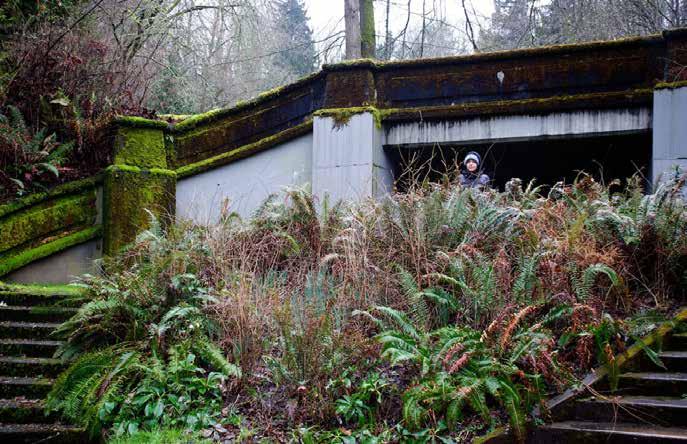
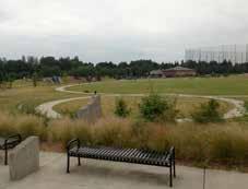
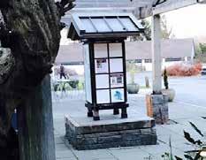
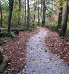
6 NEIGHBORHOOD CONTEXT

7 HISTORIC CONTEXT
8 SITE ANALYSIS To Lake Washington th Ave S S Lander St LEGEND Property Line Neighborhood Entrance SDOT Property Seattle Parks Property 110 Mt. Baker Park Main Trail Project Boundary Ex Gravel Trail Ex Dirt Trail PM Sun AM Sun Ex Concrete Steps Ex Wood Steps Prevailing Winds Ellsworth Storey House (Historical Site) To Playground & Tennis Courts


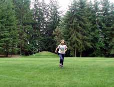
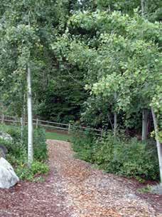
9 SITE CHARACTER


10 SITE CHARACTER

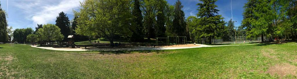
11 SITE CHARACTER


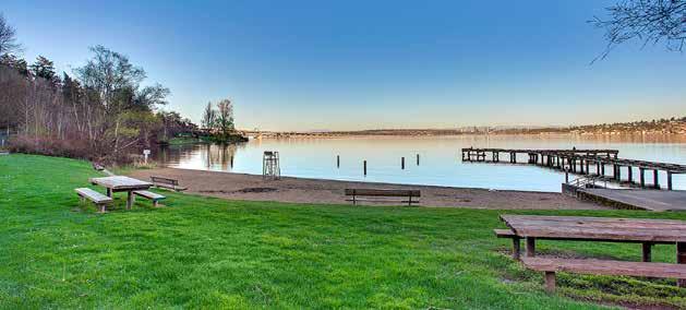


12 PARK CHARACTER


13 OLMSTED INFLUENCE


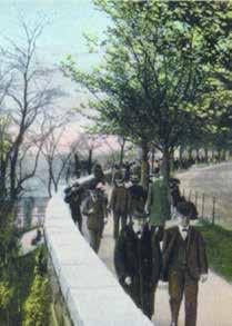
14 OLMSTED DETAILS

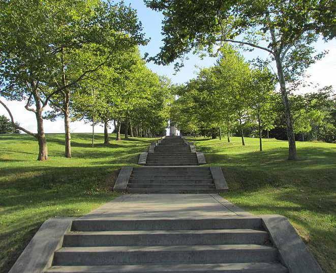


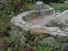
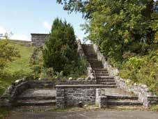
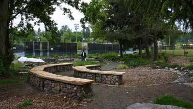
15 INSPIRATION


16 INSPIRATION
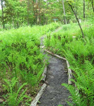


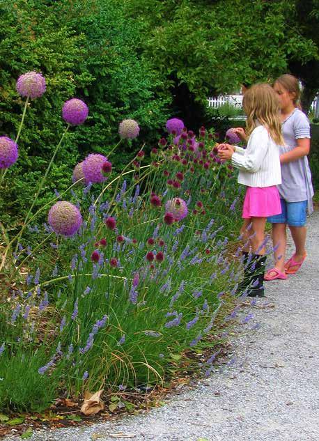


17 INSPIRATION
18 SUMMARY OF GROUND RULES Listen to everyone s viewpoint, common good is informed by all Everyone participates, together we know more Engage, not recruit Practice generosity & be civil Be positive & constructive; propose flexible solutions Be willing to change your mind when hearing new information Seek common ground Look for win-win solutions where all can succeed


19 DESIGN GAME ELEMENTS Bike Rack Artistic Handrail Benches Picnic Tables Standard Handrail Guardrail Standard Staircase Map / Wayfinding Seatwall Olmstedian Staircase Art / Sculpture Bike Runnel Natural Stone Staircase Gathering Area Interpretive Signage (Park/ Neighborhood History)


20 DESIGN GAME ELEMENTS Donor Recognition Concrete Path Rain Garden Overlook Asphalt Path Lawn / Turf Formal Entrance Gravel Path Low Maint. Eco Turf Natural Play Area Wood Chip Path Restoration/Habitat Plantings Kiosk Traffic Calming / Street Mural Polinator Pathway


21 DESIGN GAME EXAMPLE


22 COMMUNITY INPUT Group 1 Bench Formal Entry Stone Stairs Asphalt Path Artistic Railings Rain Garden Asphalt Path Asphalt Path Comments: Little bike trail Like formal entry Include a bench Natural stone staircase and artistic railing Bike runnel (minority voice in the group) Make lower trail asphalt, gravel has been used at the lake, it was costly and does not work Keep it simple
 Art on raisers stairs -")
 Take out guardrail and add seatwall Stairs with a stroller path- accessible for kids on bikes Artistic railing Native plantings throughout Sledding")
23 Group 2 Group 3 Olmsted Staircase Si ng Wall Artistic Railings Barkchip Path Map/Wayfinding None Seat Wall Picnic Tables Bike Runnel Olmsted Staircase Artistic Railing Bike Runnel None Comments: Sledding path Biking path stairs and path to accommodate bikes and strollers Remove shrub on north side of pathway, just above lower stairs Native plants (along north edge) Art on raisers stairs - donors. Leaf theme Olmsted seat wall with bollard (top) Take out guardrail and add seatwall Stairs with a stroller path- accessible for kids on bikes Artistic railing Native plantings throughout Sledding hill Remove hazelnut, more room and use Could bike path be the sledding hill? Staircase side to side kills all other uses. N. trail - wood chip Street side = Olmsted stairs - more natural below May/wayfinding at bottom Like the idea of fundraising through tiles Ceramic tiles by Mike Rosen at seating area Comments: Maintain trail so have a direct route to playground and beach Bike runnel Plaza at top Picnic table at top with light Can you lessen the slope? Can we do serpentine path with stairs? Remove existing guardrail and replace with seatwall Nice and sunny and dry Maybe picnic table or two- kid space - could be nice Revisit Olmsted steps down below Serpentine trail for bikes and strollers- trail for all 20 yrs ago, slipped and broke arm here
 Bicycle ramp (top) Flowers along green strip (top) Switch back sloping path.")
 Focus on aesthetics Beautiful location, park Make accessible for bike riders, hard to push bike up hill, now it s dangerous A lot of invasives to remove Use")
24 Group 4 Group 5 Seat Wall Formal Entry Overlook Restoration/Habitat Plantings Bike Runnel Artistic Railing Rain Garden Seat Wall Formal Entry Donor Recognition Concrete Path Bike Runnel Artistic Railings Bench Art/Sculpture Kiosk Comments: Start the staircase within the sidewalk (at the top) Bicycle ramp (top) Flowers along green strip (top) Switch back sloping path. Porous material - bikable kids Bikable for little kids & strollers Pull out flat area (middle b/w staircases) Omstedean staircase or artistic handrail Tear out invasive plants and put in natives! Get rid of roted wood planks (at bottom) Focus on aesthetics Beautiful location, park Make accessible for bike riders, hard to push bike up hill, now it s dangerous A lot of invasives to remove Use natives, rain gardens, help habitat Invasive hard habitat Like Olmstedian influence - compatible with park and neighborhood Maintain lower paths Improve upper areas Two houses contrast one another Could be work of art Resurrect parks committee through Mt. Baker Community Club Comments: Sled hill Bikable tobaggon runnel Kill tree (shrub in middle b/w staircases) Synthetic track surface path (bottom north trail) Kill some trees (bottom by Mt Baker park main trail) Synthetic track material path (bottom) Keep it open Sledding Hill (good) / bike access 2 seatwalls for formal entrance Donor recognition Bike runnel Overlook Remove shrub/ hazelnut Kill some trees Bobsled type trail, S trail 365 days Sculpture somewhere bottom like at community club Lower paths - rubber synthetic turf Surfaces with good traction
 Comments: Dog poop bag dispense (at top) Concrete Bag dispenser for dogs Seat wall at top of trail Stairs & ramp at upper area Liked")

25 Group 6 Group 7 Olmstedian Staircase Seatwall Interpretive Signage (Park/Neighborhood History) Benches Concrete Path Restoration/Habitat Plantings None Art/Sculpture Olmstedian Staircase Seat Wall Bike Runnel Natural Stone Staircase (Park/Neighborhood History) Comments: Dog poop bag dispense (at top) Concrete Bag dispenser for dogs Seat wall at top of trail Stairs & ramp at upper area Liked ideas proposed by other groups Comments: Swale (middle) along sides of path Steps/ramp to (transition to the) path (at the north and south) Steep Serpentine trail to get down from upper area Wide enough for bikes, strollers, etc. Formal entry Art work- welcome to our park sculpture and si ng bench Contemplative area/ character below Integrate swales down path to help manage run-off from path - nice to see this around town Keep lower paths - people will take direct route, anyway Sign about project Serpentine trail at Freeway Park is good example Can you do steps and serpentine trail at top?


26 LOCAL PRECEDENT / COMPARISON Mt. Baker Safe Access Site Upper Entrance Plan View View from Below Charlestown Hillclimb Upper Entrance Plan View View from Below
 130 120 15% Slope (Approx.")
27 Existing Conditions 34th Ave S Sylvan Terrace Dr. S. To Lake Washington S Lander St LEGEND Property Line Project Boundary Ex Gravel Trail Ex Dirt Trail Ex Concrete Steps Ex Wood Steps Neighborhood Entrance Overlook % Slope (Approx.) % Slope (Approx.) SDOT Property Seattle Parks Property 110 Mt. Baker Park Main Trail Scale: 1 = 10-0 (24 x36 Sheet) Neighborhood Entrance N Ellsworth Storey House (Historical Site) % Slope (Approx.) To Playground & Tennis Courts


 Trail +120.")


28 Alternative A 34th Ave S Asphalt Trail Concrete Circles Boulders Concrete Stairs Plinths h f A Flagstone C B 5% 8% D 8% E 9% Slope N g Ellsworth Storey House (Historical Site) 40 Scale: 1 = 10-0 (24 X36 SHEET) Trail Neighborhood Entrance 10 Mt. Overlook Concrete Trail Rain Garden rk Main Baker Pa S Lander St Pervious Concrete 110 E 13% Slope Seattle Parks Property 12% SDOT Property Project Boundary 12% Property Line Neighborhood Entrance LEGEND To Lake Washington g Sylvan Terrace Dr. S. To Playground & Tennis Courts A Historic Character Prominent Entry Features b Flagstone Landings c Stone Seatbench d 3 Switchbacks, 12% Slope e Asphalt Connector Trails, 8% Slope g f Gardenesque Plantings Interpretive Signage / Wayfinding hi Historic Railing I Donor Recognition Tiles


29 34th Ave S Alternative B Sylvan Terrace Dr. S. Existing Slope To Lake Washington S Lander St Scale: 1 = 10-0 (24 X36 SHEET) LEGEND Property Line Project Boundary Gravel Trail Concrete Trail Asphalt Trail Concrete Circles Boulders Flagstone Concrete Stairs Plinths Neighborhood Entrance Overlook Neighborhood Entrance N A b 12% 12% 140 C Ellsworth Storey House (Historical Site) 130 d f 18% Slope 120 h h e e SDOT Property Seattle Parks Property 110 Existing Slope g Mt. Baker Park Main Trail Rain Garden To Playground & Tennis Courts A b c d e f g h Simple Design Street Plantings Stairs from Overlook Natural Seating 2 18% Slope Convert Connector Trails to Gravel Native / Habitat Plantings Natural Play Elements Standard Railing Lower Cost / Faster Build
ANCHORAGE PARK REPORT CARD Assessing A Park s Appearance, Function, & Condition
 ANCHORAGE PARK REPORT CARD Assessing A Park s Appearance, Function, & Condition Park Name: Is Your Park an A or an F? Your Name: Contact Information Optional: Date: General Instructions: Phone: Email:
alum creek park public workshop January 16, 2014
 alum creek park public workshop January 16, 2014 brief History Schneider Park Early 2000 s - Clean Ohio Fund - Acquisition & Invasive Species Removal SWBMP - Capital University agrees to assist with land
Draft Master Plan for Franklin Park
 Draft Master Plan for Franklin Park Metro Parks Tacoma with SiteWorkshop November 2009 I. overview & background Process & History Master Plan Process The Master Plan is based on a community involvement
PUBLIC RIGHT-OF-WAY IN THIS CHAPTER PUBLIC REALM
 PUBLIC RIGHT-OF-WAY This section provides design guidelines for improvements in the public right-of-way. The public right-of-way refers to streets, sidewalks, non-vehicular thoroughfares, parks and greenways
Charles P. Johnson and Associates. Annapolis Landscape Architects
 Charles P. Johnson and Associates Annapolis Landscape Architects AGENDA Introduction Project Limits and Scope Site Analysis Opportunities & Constraints Program Goals Image Boards Design Alternatives Pros
SF REC & PARK STANYAN STREET IMPROVEMENT. Supervisor London Breed District 5. Project Manager Dan Mauer Recreation and Parks Department
 SF REC & PARK STANYAN STREET IMPROVEMENT PLANNING PRESENTATION WEDNESDAY, OCTOBER 19, 2016 Supervisor London Breed District 5 Project Manager Dan Mauer Recreation and Parks Department Design Team William
Long Branch-Wayne Local Park Renovation Project
 Montgomery Parks Long Branch-Wayne Local Park Renovation Project Community Meeting #2 September 20, 2016 Oak View Elementary School 7:00-9:00 PM Welcome / Team Introductions M-NCPPC (Montgomery Parks)
Barrie Park Site Master Plan
 Barrie Park Site Master Plan Community Meeting Number 4 May 13th, 2015 Barrie Park Site Master Plan: Process A Blue Print for the Future Already taken place: Site walkthrough, Focus Groups, 3 Community
Silver Creek Subdivision Public Park
 Silver Creek Subdivision Public Park Design Team: team80026 Munding Design Lead Consultant Gaia Designs Landscape Architect Wildrye Design Landscape Architect Akamai Design Civil Engineer introduction
Rosslyn Highlands Park + Coordinated Open Spaces Plan (Plan Adoption) County Board Meeting September 24, 2016
 County Board Meeting September 24, 2016") Rosslyn Highlands Park + Coordinated Open Spaces Plan (Plan Adoption) County Board Meeting September 24, 2016 BACKGROUND The County Board shall consider adoption of the proposed Rosslyn Highlands Park
Rosslyn Highlands Park + Coordinated Open Spaces Plan (Plan Adoption) County Board Meeting September 24, 2016 BACKGROUND The County Board shall consider adoption of the proposed Rosslyn Highlands Park
Montana Rail Link Park
 Montana Rail Link Park Neighborhood Open House A Missoula Community Partnership WITH LEADERSHIP FROM THE FRANKLIN TO THE FORT & SOUTHGATE TRIANGLE NEIGHBORHOODS Sovereign Hope Church, (1919 North Ave.)
WELCOME PG&E HUNTERS POINT COMMUNITY OPEN HOUSE THANK YOU FOR COMING PG&E
 WELCOME PG&E HUNTERS POINT COMMUNITY OPEN HOUSE THANK YOU FOR COMING NEWHALL ST JENNINGS ST B SHORELINE I SHORELINE EVANS AVE J C/D MIDDLE POINT ROAD OPERATING SUBSTATION A SHORELINE H Remediation Complete
Planning Board Hearing October 20th, 2016
 Planning Board Hearing October 0th, 06 Developer: Real Estate Management & Leasing: Architect: Transportation Engineers: Landscape Architect: Civil Engineer: THE ARSENAL PROJECT Planning Board AGENDA Introduction
Design Alternatives Workshop. Hilfiker Park Master Plan Workshop #2
 Design Alternatives Workshop Hilfiker Park Master Plan Workshop #2 Agenda for Tonight Staff Presentation (40 min) Introduction Master Plan Process Planning Context What We ve Heard So Far Design Alternatives
Design Considerations
 Essential to the development of a successful Master Plan for the Park Complex is input from the community that the park will serve. The community outreach component of the planning process included numerous
BENJAMIN BANNEKER PARK FRAMEWORK PLAN (PLAN ADOPTION)
") BENJAMIN BANNEKER PARK FRAMEWORK PLAN (PLAN ADOPTION) COUNTY BOARD MEETING DECEMBER 16, 2017 County Board Consideration: Adopt the Benjamin Banneker Park Framework Plan and Design Guidelines Framework
BENJAMIN BANNEKER PARK FRAMEWORK PLAN (PLAN ADOPTION) COUNTY BOARD MEETING DECEMBER 16, 2017 County Board Consideration: Adopt the Benjamin Banneker Park Framework Plan and Design Guidelines Framework
COMPLETE GREEN STREET CHECKLIST
 COMPLETE GREEN STREET CHECKLIST This document was developed to dissect the structure of an urban street and explore opportunities to make our streets more complete while also integrating green street strategies.
VEHICULAR AND PEDESTRIAN CIRCULATION
 This perspective sketch communicates the intended character and quality of a proposed streetscape design. Locate benches near a major intersection where people tend to gather. Seating and lighting provide
Community Meeting #2. Cabrillo Playground Renovation A 2008 Clean and Safe Neighborhood Parks Bond Project
 Cabrillo Playground Renovation A 2008 Clean and Safe Neighborhood Parks Bond Project Community Meeting #2 September 22, 2010 District Supervisor Eric Mar Paulina Araica, Project Manager Andy Maloney, Architect
PHASE 3-4 PARKS SOUTH PARK AND CHANNEL PARK
 PHASE 3-4 PARKS SOUTH PARK AND CHANNEL PARK Sheet List L1.0 L2.0 L3.0 L4.0 L5.0 L6.0 L7.0 L8.0 L9.0 L10.0 L11.0 L12.0 L13.0 L14.0 L15.0 L16.0 L17.0 L18.0 L19.0 L20.0 L21.0 L22.0 Cover Open Space Context
City of Plattsburgh DRI: Downtown Streetscapes & Riverfront Access. Downtown Streetscape and Riverfront Access Design
 City of Plattsburgh DRI: Downtown Streetscapes & Riverfront Access Welcome Thank you for coming this evening. Agenda PART I - Project Context The Downtown Revitalization Program Our DRI Projects Other
A 2012 Clean and Safe Neighborhood Parks Bond Project. Katy Tang, District Supervisor. Jasmine Kaw, Landscape Architect Will Kwan, Architect
 West Sunset Park A 2012 Clean and Safe Neighborhood Parks Bond Project Community Meeting #2 November 20, 2013 Katy Tang, District Supervisor Dan Mauer, Project Manager Jasmine Kaw, Landscape Architect
12 Foot Davis and Adjacent Sites
 Peace River, Alberta Proposed Concept Design Presentation and Discussion January 26, 2010 Peace River Provincial Recreation Area 12 Foot Davis Grave Site Dr. Greene Cairn North Environments Landscape Architects
Project purpose. advise. The purpose of the Beaumaris Lake Open Space Rehabilitation project is to: + Develop a Functional Program Concept
 Project purpose owns Road Beaumaris Road The purpose of the Beaumaris Lake Open Space Rehabilitation project is to: + Develop a Functional Program Concept + Guide Rehabilitation of Landscape and Community
WELCOME OLD SOUTH The Green Community Input Session. April 6, 2017
 WELCOME OLD SOUTH The Green Community Input Session April 6, 2017 AGENDA Welcome/Introductions Project History Heritage Status Existing Conditions What We ve Heard to Date Design Principles Concept Plan
AVONDALE ESTATES GREENSPACE AD-HOC COMMITTEE
 AVONDALE ESTATES GREENSPACE AD-HOC COMMITTEE INVENTORY AND RECOMMENDATIONS REPORT November 7, 2018 Our Mission Statement: To provide assistance and support, through professional expertise in matters of
TOWN COUNCIL / PLANNING COMMISSION
 Workshop #3 TOWN COUNCIL / PLANNING COMMISSION January 20, 2011 Consultant Team In Attendance Tonight BMS Design Group Nevada City and San Francisco Michael Smiley, AICP, ASLA Partner-in-Charge Nancy L.
MASTER PLAN IMPLEMENTATION COSTS. Appendix A
 Appendix A MASTER PLAN IMPLEMENTATION COSTS Town of Bradford West Gwillimbury HENDERSON COMMUNITY PARK MASTER PLAN IMPLEMENTATION COSTS Draft Order of Magnitude Costing Revised 5/27/2014 ITEM DESCRIPTION
PIKE PINE RENAISSANCE: ACT ONE. October 19, 2017
 PIKE PINE RENAISSANCE: ACT ONE October 19, 2017 WATERFRONT SEATTLE PROGRAM PROJECT INTRODUCTION Pike and Pine streets, between First and Melrose avenues Pedestrian and streetscape improvements Budget:
TA B L E O F C ON T EN T S
 TA B L E O F C ON T EN T S Introduction 1 Site Analysis 2 EXISTING TREE ANALYSIS 3 Community Outreach 5 PUBLIC WORK SHOP #1 GENERAL PUBLIC 6 PUBLIC WORKSHOP #2 4 TH OF JULY CELEBRATION 9 PUBLIC WORKSHOP
A.9. Cannon River. Campostella Park. Adjacent Industrial & City Facility Uses
 Campostella Park Classification: Nature Area 14 acres Character: This park is an undeveloped, heavily wooded natural open space park located along the Cannon River, just to the southwest of Babcock Park
VISION PLAN PRESENTATION - SEPTEMBER 28, 2013
 AREAS OF IMPROVEMENT E A POOL HOUSE POOL DECK B B MAIN BUILDING UPPER PLAZAS A D F G C MAJOR BLEACHERS DUGOUTS FIELD MAIN COURTYARD D REGGIE PARK C E SPORT COURT ADA RAMP H F G H TENNIS COURTS KITCHENETTE
AvalonBay Communities + BRIDGE Housing. Mission Housing Habitat for Humanity Pacific Union Development Corporation
 AvalonBay Communities + BRIDGE Housing Mission Housing Habitat for Humanity Pacific Union Development Corporation Tonight s Agenda Recap of discussion from last CAC meeting Updates on meetings with Stakeholders
LELAND & VISITACION PARK COMMUNITY MEETING
 LELAND & VISITACION PARK COMMUNITY MEETING July 16th, 2016 SAN FRANCISCO RECREATION AND PARK GLS LANDSCAPE ARCHITECTURE BAYSIDE DEVELOPMENT LLC MEETING OBJECTIVES 1. FEEDBACK ON LELAND / BAYSHORE CORNER
Preliminary Sketch Plan for Fort Hunter Park
 Preliminary Sketch Plan for Fort Hunter Park Public Presentation November 19, 2009 Dauphin County Parks and Recreation 100 Fort Hunter Road Harrisburg, PA 17110 (717) 599-5188 www.dauphinc.org THOMAS COMITTA
South Bend Park. Visioning Plan
 South Bend Park Visioning Plan 2007 South Bend Park, Visioning Program, Executive Summary The South Bend Park Visioning Program began with the receipt of an application from the Friends of South Bend Park,
Subject: Expo Light Rail - Revision of the Terminus Station North Entrance Design
 Information Item Date: June 12, 2012 To: Mayor and City Council From: David Martin, Director, Planning & Community Development Martin Pastucha, Director, Public Works Kathryn Vernez, Deputy City Manager
BISCUIT RUN PARK MASTER PLAN
 BOARD OF SUPERVISORS November 14, 2018 BISCUIT RUN PARK MASTER PLAN COUNTY OF ALBEMARLE ANHOLD ASSOCIATES Contents Project Introduction Property Background County Park Planning Process Existing Site &
Port of Camas-Washougal Waterfront Trail Master Plan
 Port of Camas-Washougal Waterfront Trail Master Plan The Port s facilities are the products of its mission: To make strategic investments that enhance the community s quality of life by bringing jobs,
Waterlily Playscape Committee Waterlily Playscape, Waterlily Park, Ocean Shores Draft Concept Plan. G Issue D 14/07/16
 Waterlily Playscape Committee Waterlily Playscape, Waterlily Park, Ocean Shores Draft Concept Plan Issue D 14/07/16 New two level wharf for fishing and interacting with waters edge (exact location to be
South th E ast Communit ity Centre (SECC)
") South East Community Centre (SECC) 1 New Park Design & Community Centre Update Thursday, February 8, 2018 Public Open House Thank you for attending this Open House! The town and the Consulting Team will
South East Community Centre (SECC) 1 New Park Design & Community Centre Update Thursday, February 8, 2018 Public Open House Thank you for attending this Open House! The town and the Consulting Team will
Update on Angus Glen. Community Park. Development Services Committee. December 6, Part A ANGUS GLEN PARK MASTER PLAN. Town of Markham & LA+ED
 Update on Angus Glen Community Park Part A Development Services Committee December 6, 2011 Agenda Overview of Project Background Current Project Status Proposed Park Program and Activities Revised Master
Throughout. square. (Crystal City Vision Plan 2050)
") 1: Terms related to the PSMP document 1 public space (see also public realm, civic space) An open space designated on the regulating plan, accessible to all, including Plazas, Mini Parks, and Neighborhoods
1: Terms related to the PSMP document 1 public space (see also public realm, civic space) An open space designated on the regulating plan, accessible to all, including Plazas, Mini Parks, and Neighborhoods
Washington Park Diagonal
 Public Input Meeting August 3, 2011 Nicole Stahly RLA DPR Project Manager Jesse Clark RLA, LEED Stream Design Paul Thomas RLA Stream Design Kerry White RLA Urban Play Studio Tonight s Agenda 1st Meeting:
Terrace View Park. Master Plan
 Terrace View Park Master Plan Table of Contents Terrace View Park Master Plan Page Executive Summary 1 Project Background 3 Master Planning Process Existing Conditions Master Plan 9 Park Zones and Amenities
Dowdy Park. Concept Plans TOWN OF NAGS HEAD NORTH CAROLINA. Developed by: Albemarle & Associates, Ltd VHB/ Vanasse Hangen Brustlin, Inc.
 TOWN OF NAGS HEAD NORTH CAROLINA Concept Plans Developed by: Albemarle & Associates, Ltd VHB/ Vanasse Hangen Brustlin, Inc. Site Looking Southeast Dowdy Park Existing Conditions Nags Head Woods Sound Future
Landscape and Streetscape Design 2.5
 Landscape and Streetscape Design 2.5 2.5.1 Goals 2.5.2 Planting 2.5.3 Sidewalks and Pavement 2.5.4 Furnishings 2.5.5 Walls 2.5.6 Lighting 2.5.7 Stormwater 2.5.8 Street Cross Sections 2.5 LANDSCAPE AND
Call for Artists for: Design and Construction of Environmental Art Activation Story Mill Community Park, Bozeman, MT
 Call for Artists for: Design and Construction of Environmental Art Activation Story Mill Community Park, Bozeman, MT Seeking artists to design, fabricate and install art elements in the nature sanctuary
WARM SPRINGS PARK MASTER PLAN
 TABLE OF CONTENTS page 1.0 Introduction and Overview 1 2.0 Information Gathering 2 3.0 Conceptual Alternative Development 8 4.0 Master Plan Development 14 5.0 Construction Cost Estimates 19 LIST OF FIGURES
Proposed Park Master Plan: The Master Plan has been revised to incorporate suggestions received in response to the Park Survey:
 March 31, 2010 SUBJECT: Morningcrest Park Master Plan Dear Resident, I would like to thank you for your comments on the Morningcrest Park that was mailed out and posted online on the City website in February,
MASTER PLAN for the EARL NEWHOUSE WATERFRONT
 MASTER PLAN for the EARL NEWHOUSE WATERFRONT on RESERVOIR POND - CANTON, MA Community Meeting #2 - Thursday, January 11 th PROJECT INTRODUCTION Project Goals: To prepare a MASTER PLAN which develops the
Reconnecting to a Forgotten River St. Cloud MN. Aaron Hanson Design Design Thesis LA 572, Thesis, Spring 2012
 Reconnecting to a Forgotten River St. Cloud MN Aaron Hanson Design Design Thesis LA 572, Thesis, Spring 2012 site context 2.5 Miles Sartell St. Cloud to Fargo 170 Miles (2 hrs 45 mins) Hwy 10 infrastructure
New Park / Entry Court & Plaza Concept Design
 New Park / Entry Court & Plaza Concept Design The SECC Public realm is proposed to have a focus on health, wellness, and community and that site users will include patrons of the neighbourhood. The block
The open space system should provide connective elements, relate to natural resources, and enhance the suburban character of the landscape..
 The open space system should provide connective elements, relate to natural resources, and enhance the suburban character of the landscape.. Mixed-use and infill development should maintain or enhance
MICHAELS AVE RESERVE. Draft Concept Plan of South Section September Contents. 1 Project Background. 2 Masterplan Timeline
 MICHAELS AVE ESEVE Draft Concept Plan of South Section September 05 Contents Project Background Masterplan Timeline Photographic Analysis Option A - Updated Masterplan 5 Option B - Alternative Design 6
Great Neck Library Landscaping Committee Wednesday, January 18, 2017, 7:30pm Main Library
 Great Neck Library Landscaping Committee Wednesday, January 18, 2017, 7:30pm Main Library Board Members: Robert Schaufeld, Chair (RS) Marietta DiCamillo (MD) Josie Pizer (absent) JP Francine Ferrante Krupski
Fifth and Detroit Street Design May 2017 Capital Improvements Committee. DOWNTOWN Street Design
 1 Fifth and Detroit Street Design May 2017 Capital Improvements Committee Agenda 2 Review Street Configuration Prior Meeting Review Outreach Synopsis Functional Street Design Refinements Curb Edge, Turning
MOBILITY35 AESTHETICS
 MOBILITY35 AESTHETICS Aesthetics Working Group 3 March 29, 2016 What we heard regarding three themes Connectivity: Improve east/west pedestrian connections Safe and well marked Local identity defined by
Route 347. New York State Department of Transportation Region 10, Long Island. THE GREENING of ROUTE 347
 The GREENING of Route 347 The Greening of Route 347 The Greening of Route 347: History 3 The Greening of Route 347 4 The Greening of Route 347 5 The Greening of Route 347 Smith Haven Mall 6 The Greening
Main Street Conversion Site
 Main Street Conversion Site Borough of Brooklyn, New York Preliminary Presentation Park Expansion Design & Development Committee 13 September 2012 Michael Van Valkenburgh Associates, Inc. Landscape Architects,
Kittson Parkway / Watershed Park Parking Lot
 Kittson Parkway / Watershed Park Parking Lot Date Constructed: Summer 2005 Site Location / Description: Kittson Parkway, North Delta, British Columbia. Permeable parking lot adjacent to Watershed Park;
SF REC & PARK STANYAN STREET IMPROVEMENT. Supervisor London Breed District 5. Project Manager Dan Mauer Recreation and Parks Department
 SF REC & PARK STANYAN STREET IMPROVEMENT COMMUNITY MEETING #3 THURSDAY, JANUARY 25 TH, 2018 Supervisor London Breed District 5 Project Manager Dan Mauer Recreation and Parks Department Design Team William
SF RECREATION & PARK DEPARTMENT URBAN TRAILS PROGRAM
 SF RECREATION & PARK DEPARTMENT URBAN TRAILS PROGRAM TRAIL IMPROVEMENTS October 5, 2011 TRAIL IMPROVEMENTS 6:30 8:00 p.m. AGENDA WELCOME & INTRODUCTION URBAN TRAILS PROGRAM OVERVIEW TRAIL IMPROVEMENTS
RPD GEORGE CHRISTOPHER PLAYGROUND COMMUNITY MEETING 1 SEPTEMBER 24, Duncan St
 RPD GEORGE CHRISTOPHER PLAYGROUND COMMUNITY MEETING 1 SEPTEMBER 24, 2015 Duncan St Supervisorial District 8 Supervisor Scott Wiener 1 Agenda Welcome & Introductions Purpose of Meeting Ground Rules Project
Errol Heights Park and Community Garden Frequently Asked Questions March 22, 2018
 Errol Heights Park and Community Garden Frequently Asked Questions March 22, 2018 Question 1: What improvements are planned for Errol Heights Park? How will the community be engaged in the process to shape
4 Semi-Private & Private Open Spaces
 4 Semi-Private & Private Open Spaces 4.1 Semi-private Open Space 4.1.1 Common Courtyards The common courtyards for each complex will be designed and programmed for the typical owners living there. They
Pomegranate Center and Tully s Coffee Gathering Grounds program partnership Butterfly Park Gathering Place Project Preliminary Design I.
 Pomegranate Center and Tully s Coffee Gathering Grounds program partnership Pomegranate Center, ARTS /A Reason To Survive, Olivewood Gardens, San Diego Foundation, and City of National City Butterfly Park
Community Earth Day Celebration
 1 Friends of the End Community Earth Day Celebration Saturday, April 22nd, 2017 The Dead End at Albemarle Road and East 17th Street THE PROJECT On Saturday, April 22nd, in celebration of Earth Day 2017,
MADISON MANOR PARK RENOVATIONS
 MADISON MANOR PARK RENOVATIONS COMMUNITY KICK-OFF MEETING MINUTES To: Wilfredo Calderon, Steven Torgerson (AMT), Tom Mitchler, Kevin Stalica, Vincent Verweij, Greg Anselene, Chris Willett, Peter Alchin,
L-1 LEGEND HOMES AT DEER HILL LAFAYETTE, CALIFORNIA
 LEGEND Soccer Field 100 Yards (300 ft) x 60 Yards (180 ft) 6 Vinyl-Coated Chainlink Fence 15 Vinyl-Coated Chainlink Fence DE See Sheet L-2 for Filed North Enlargement Plan ER Park Boundary HIL LR OA D
University of the District of Columbia Van Ness Campus Master Plan Community Open House 3. December 8, 2010
 University of the District of Columbia Van Ness Campus Master Plan Open House 3 December 8, 2010 Introductions Sequence of Work: Campus Master Plan BEGIN: INTRODUCE AND START WORK Project Initiation Team
Philip A. Ginsburg, General Manager Toks Ajike, Acting Planning and Capital Program Director
 Date: March 7, 2018 To: Through: From: Subject: Recreation and Park Commission Capital Committee Philip A. Ginsburg, General Manager Toks Ajike, Acting Planning and Capital Program Director Dan Mauer,
W&OD PARK MASTER PLAN. The City s Greenest Street. DRAFT W&OD Trail Master Plan v4.docx Page 1
 W&OD PARK MASTER PLAN Adopted XXX-XX-XXXX The City s Greenest Street DRAFT W&OD Trail Master Plan v4.docx Page 1 Introduction and Purpose The Washington & Old Dominion Railroad Regional Park (W&OD) (which
Public Workshop #2 Summary
 Public Workshop #2 Summary Project Number: Project Title: 2320.01 (R&M) MOA Parks and Recreation Muldoon Town Square Park Master Plan Subject: Muldoon Town Square Park Master Plan Public Workshop #2 Author:
SOUTH PARK. Construction of a Portion of South Park at Fresh Kills Park, Staten Island
 SOUTH PARK Construction of a Portion of South Park at Fresh Kills Park, Staten Island FRESHKILLS PARK FIRST PHASE OF SOUTH PARK FRESHKILLS PARK CONTEXT SOUTH PARK EXISTING CONDITIONS PROJECT OPPORTUNITIES
Old Town Neighborhoods Plan. Choices Event Wednesday, December 9, 2015
 Old Town Neighborhoods Plan Choices Event Wednesday, December 9, 2015 Agenda 6:00 6:10 p.m. Welcome + Sign In 6:10 6:30 p.m. Presentation 6:30 8:00 p.m. Workshop + Open House Seeking your input on: Neighborhood
Comment NATURAL ELEMENTS & PLANTINGS
 Park at Gables N. Rolfe Public Meeting, 4/09/14 Public Comments by Topic Location of Comment Comment NATURAL ELEMENTS & PLANTINGS #1 [Like] The preservation of nature [Like] The large amount of green [Like]
Public responses to the question what do you want Muscatine to be, 20 years from now? (Responses were categorized as follows)
") Mississippi Drive Kickoff Event 9/1/2015 Blue Zones Kickoff Presentation Public responses to the question what do you want Muscatine to be, 20 years from now? (Responses were categorized as follows) Physical
Mississippi Drive Kickoff Event 9/1/2015 Blue Zones Kickoff Presentation Public responses to the question what do you want Muscatine to be, 20 years from now? (Responses were categorized as follows) Physical
ROSLINDALE BRANCH, BPL COMMUNITY PRESENTATION #2 MARTIN J. WALSH, MAYOR CITY OF BOSTON PUBLIC FACILITIES DEPARTMENT 02/07/2018
 ROSLINDALE BRANCH, BPL COMMUNITY PRESENTATION #2 MARTIN J. WALSH, MAYOR CITY OF BOSTON PUBLIC FACILITIES DEPARTMENT 02/07/2018 MEETING AGENDA TEAM & GOALS ENTRY DESIGN PROGRESS INTERIOR PLAN DESIGN PROGRESS
PARK DATA THEMES SUMMARY:
 area and identified key themes that should be addressed in the upcoming design process. The following is a compilation of the themes identified (organized by park). Not every park was addressed in this
Appendix E Section 4(f) Evaluation
 Evaluation") Appendix E Section 4(f) Evaluation Appendix E Draft Section 4(f) Evaluation E.1 Introduction This appendix addresses a federal regulation known as Section 4(f), which protects parks, recreation areas,
Appendix E Section 4(f) Evaluation Appendix E Draft Section 4(f) Evaluation E.1 Introduction This appendix addresses a federal regulation known as Section 4(f), which protects parks, recreation areas,
Planning Stage. Mosaic Park. Long Term Project. Restoration of 4 Mile Run. Planning Stage. Herndon and 13 th. Project Underway. Clarendon Central Park
 Planning Stage Long Term Project Planning Stage Project Underway Mosaic Park Restoration of 4 Mile Run Herndon and 13 th Clarendon Central Park Arlington County Parks, Recreation and Cultural Resources
3.1 community vision. 3.3 required plan elements
 Chapter 3 Community Form 3.1 community vision 3.2 Parks & landscaping concepts 3.3 required plan elements D R A F T 20 Community Form Chapter 3 3.0 Community form 3.1 community vision The Specific Plan
Point Defiance Park. Master Plan Update. April 23 rd 2015
 Point Defiance Park Master Plan Update April 23 rd 2015 Public Participation 1/29, 2/26, 3/26 & 4/23 Tonight s Agenda: Introduction: March Meeting Recap: Overview Feedback Responses Presentation of Master
Norwood Public Library Rendering
 The new Norwood Public Library is based on a lot that is a few blocks south of Highway 145 (Main Street) in Norwood, Colorado at the intersection of Pine Street and San Miguel Street. It is owned by the
Revitalization of Durand Park. Durand Park Proposal June 2008
 Revitalization of Durand Park Durand Park Proposal June 2008 Background! " Property purchased in 1974! " Opened in September 1975, largely thanks to the work of the DNA! " Only park in the Durand: 12 000
CHAPPLES PARK MASTER PLAN
 CHAPPLES PARK MASTER PLAN Presentation of Preliminary Development Options Public Open House #2 Wednesday November 2 nd, 2016 TONIGHT S AGENDA 1. Welcome & Introductions 2. Presentation by Sierra Planning
SDOT DCLU. Director s Rule Seattle Design Guidelines for Link Light Rail, Beacon Hill Station. City of Seattle
 SDOT DCLU Director s Rule 11-2003 Applicant: Page Supersedes: City of Seattle Department of Transportation (SDOT) Department of Design, Construction and Land Use (DCLU) 1 of 10 Publication: 7/3/03, 8/29/02*
Bow to Bluff Public Realm Plan Design Update
 Bow to Bluff Public Realm Plan Design Update December 017 Great public spaces encourage people to gather, recreate, explore and discover. Introduction The City of Calgary is planning to improve the corridor
PEQUITSIDE FARM ONE PROPERTY, MANY USES
 PEQUITSIDE FARM ONE PROPERTY, MANY USES Laura Campbell March 8, 2016 A plan for the public use of a historic estate Introduction At 33 acres, Peuitside Farm is the largest public owned open space in the
Hidden Pointe Landscape Master Plan. June, archi terra
 Hidden Pointe Landscape Master Plan June, 2006 t h e archi terra g r o u p 1 Table of Contents Background Purpose and Goals of the Master Plan Master Plan Process Existing Conditions Entrance Hidden Pointe
R STREET CORRIDOR NEIGHBORHOOD Site Plan and Design Review Supplemental Guidelines Checklist
 R STREET CORRIDOR NEIGHBORHOOD Site Plan and Design Review Supplemental Guidelines Checklist Applicant s Name: Project Address: Phone: Email: Applicant shall fill out the design guidelines checklist for
ROCKTON DOWNTOWN STREETSCAPE MASTER PLAN. Plan Commission Presentation April 10, 2018 Teska Associates Christopher Burke Engineering
 ROCKTON DOWNTOWN STREETSCAPE MASTER PLAN Plan Commission Presentation April 10, 2018 Teska Associates Christopher Burke Engineering AGENDA 1. Project Scope & Schedule 2. Steering Committee & Community
Access Specifications
 Access Specifications 1 Introduction At Waddesdon, we welcome all visitors and strive to make everyone s visit as comfortable and enjoyable as possible. This Access Specifications Guide provides detailed
4. Parks, Open Space and Urban Forest
 4. Parks, Open Space and Urban Forest Goals 1. Enhance parks as public gathering places for the neighbourhood 2. Refresh park facilities to attract diverse ages and activities 3. Improve waterfront access
Benedict Fountain Park Meeting Notes Wednesday, February 15, 2012
 Benedict Fountain Park Meeting Notes Wednesday, February 15, 2012 ALTERNATIVE #1 Like the big open lawn space in alternative 1. Like cohesiveness of sidewalk walk and play areas shown on alternative 1
Welcome to the. Open House
 Welcome to the 5th Street to Kinsman Road Open House November 14 5:30 7:00 p.m. Please sign in Project Overview In December 2016, City Council adopted SW 5th Street as the preferred alignment to connect
More than 30 adults and 19 children were involved in these community workshops.
 Linwood Workshops held at Household of Faith Deliverance Church 3.29.08 and 4.05.08 What is a Design Workshop? We use the term workshop (often called charrette among design professionals) to describe a
The University District envisions, in its neighborhood
 Envisioning the University District Link Light Rail in Seattle s neighborhoods CIY OF SEALE CONCEP-LEVEL SAION AREA PLANNING RECOMMENDAION RESOLUION # 30165 EXHIBI L Vision 08.2000 he University District
M E M O R A N D U M February 21, 2018
 M E M O R A N D U M February 21, 2018 Project: Action Requested: Background Information: CP18-001, Ordinance No. 1060-A, Amendment to the City of Southlake Parks, Recreation & Open Space / Community Facilities