Settlement Nodes - North Tipperary County Development Plan 2010 (as varied)
|
|
|
- Clinton Sullivan
- 6 years ago
- Views:
Transcription

1 North Tipperary County Development Plan (as varied) Settlement Nodes - North Tipperary County Development Plan 2010 (as varied) Settlement Nodes are outlined below and comprise a written statement and associated map. These village statements have been updated by the adoption of variations number 1 and 2 of the North Tipperary County Development Plan. Variation number 1 incorporated new landzoning maps for the settlements of Borrisokane, Borrisoleigh, Cloughjordan, Littleton, Toomevara and Two-Mile-Borris and also incorporated Settlement Plans for Ballina, Ballinderry, Birdhill, Dromineer, Garrykennedy, Kilbarron, Newtown, Portroe, Puckaun, Terryglass. Variation number 2 incorporated a revised settlement hierarchy (Section 3.2.2) this amended the placement of certain settlements in the settlement hierarchy for the county. Landuse zoning categories are indicated in this Plan (as varied) and are set out below. The land use zoning objectives should be read in conjunction with the settlement plans and associated maps set out below. Phase 1 and Phase 2 lands for Residential Development Lands in certain settlement centres have been zoned Phase 1 and Phase 2. Phase 1 lands relate to lands to be developed up to 2016 and Phase 2 lands relates to land which will be available for development between 2016 and 2022, subject to Phase 1 lands being developed in the interim. Landuse zoning categories
2 North Tipperary County Development Plan (as varied) Map Index Settlement Nodes There are 32 Settlement Nodes as outlined in the Settlement Strategy (Chapter 3) of the North Tipperary County Development Plan 2010 (as varied). These are listed below in the following order: 1. Aglish 2. Balinahinch 3. Ballinderry 4. Ballingarry 5. Ballycahill 6. Ballycommon Notice Please note that this website is under construction and therefore formatting, page numbers etc may be imprecise. The planning section requests your patience in this respect. 7. Ballinree/Ballymackey 8. Ballynaclough 9. Birdhill 10. Carrig
3 North Tipperary County Development Plan (as varied) Carrigahorrig 12. Castleiney 13. Clonakenny 14. Clonmore 15. Dolla 16. Drom 17. Drumbane 18. Garrykennedy 19. Gortagarry 20. Horse and Jockey 21. Kilbarron 22. Kilcommon 23. Kileen 24. Killoscully 25. Knock 26. Lelagh 27. Loughmnore 28. Moycarkey 29. Moyne 30. Riverstown 31. Templederry 32. The Ragg
4 AGLISH SETTLEMENT PLAN
5 1.0 General Introduction and Development Context Location Aglish is a small village approximately 5km northwest of Ballingarry within the northern part of the county. Population Aglish has a population of 289 people (2006 Census) much of which is dispersed outside the settlement. This is a decrease from 292 in the 2002 Census. Settlement Form The settlement at Aglish is very traditional in origin, centred around the church. This village currently comprises a number of detached houses on large sites, located along the main road with a small number of farmsteads also sited within this area. To support opportunities for commercial and employment facilities. 3.0 Services and Social Infrastructure Water Supply Aglish is served by a public water supply. Waste Water The village is not served by the public sewer. Developments within the village are served by individual on-site septic tanks and treatment systems. Roads and Transport Infrastructure Aglish is located on the Local Road (L- 5036) close to the junction with Local road (L-1074), 2km from the Regional Road (R438). Public footpaths are evident within the village and there is a limited network of public lighting. Social and Community Infrastructure 2.0 Key aim and objectives The key aim of the settlement plan is to provide a framework for the development for appropriate residential, commercial and light industrial development and to enhance the visual character and amenities of the village. Key Objectives To facilitate low density, high quality housing appropriate to the village location. To maintain and enhance social, community and amenity facilities within the village. A Roman Catholic Church, national school, 2 public houses, and guesthouses are currently located within the settlement. 4.0 Key Messages for Aglish The settlement should be developed in a properly planned and co-ordinated manner in accordance with the zoning objectives of the settlement plan. Low density rural clustered style development is promoted on residential zoned sites. Proposals for development will require provision to be made for on-site effluent treatment. This provision will be a key factor
6 which will influence the scale and design of developments. Development should contribute towards the consolidation of the village centre close to the church and national school. 5.0 General Development Objectives Proposals for development will be assessed in accordance with the policies and objectives of the County Development Plan, as set out in the main text in Volume 1. In addition to general policy requirements for development, the Council will seek to implement the following objectives: The Council will seek to make provision and/or facilitate the provision of footpaths and public lighting to enhance the local infrastructure. The Council will seek to foster a village identity and definition of the village by facilitating the provision of hard and soft landscaping and signage. The Council will seek to control ribbon development on the approach roads to preserve and consolidate the built environment of the village. The Council will seek to ensure hedgerows, trees and any natural stone walls are preserved and maintained in any new development proposals. The Council will seek to continue to improve the approach roads to the village. The Council will seek the redevelopment of derelict sites within the settlement.
7 BALLINAHINCH SETTLEMENT PLAN
8 1.0 General Introduction and Development Context Location Ballinahinch is located approximately 7km to the north of Newport., and just south of the new M8. Population Ballinahinch is located in the Birdhill DED and had a population of 671 in This represented an increase of 83 or 12%. Settlement Form The village is linear in nature with no defined streetscape. The centre of the village is given definition by the local church and an Bothan Bui pub. The village has an attractive natural setting with landscaping and natural stone walls contributing to the visual amenity of the settlement. 2.0 Key Aim and Objectives The key aim of the settlement plan is to provide a framework for the development for appropriate residential, commercial and light industrial development and to enhance the visual character and amenities of the village. Key Objectives To facilitate low density, high quality housing appropriate to the village location. To maintain and enhance social, community and amenity facilities within the village. To support opportunities for commercial and employment facilities. 3.0 Services and Social Infrastructure Water Supply The village is serviced by a public water supply. Waste Water The village is not served by the public sewer. Developments within the village are served by individual on-site septic tanks and treatment systems. Roads and Transport Infrastructure. The village is served by local roads which links the settlement to Newport and the N7. The new M8 runs c. 500m north of the settlement which represents a locational transport link advantage for the settlement. There are no public footpaths on the local road. There is an existing network of public lighting within the settlement. Social and Community Infrastructure The village is served by church, primary school and community hall and public house. There are no public footpaths on the local road. There is an existing network of public lighting within the settlement. 4.0 Architectural and Archeological Heritage The local church and An Bothan Bui pub are listed on the record of protected structures under Volume III of the Plan.

9 An Bothan Bui S General Development Objectives Proposals for development will be assessed in accordance with the policies and objectives of the County Development Plan, as set out in the main text in Volume 1. Church S Key Messages for Ballinahinch The settlement should be developed in a properly planned and coordinated manner in accordance with the zoning objectives of the settlement plan. Low density rural clustered style development is promoted on residential zoned sites. Proposals for development will require provision to be made for onsite effluent treatment. This provision will be a key factor which will influence the scale and design of developments. In addition to general policy requirements for development, the Council will seek to implement the following objectives: The Council will seek to make provision and/or facilitate the provision of footpaths and public lighting to enhance the local infrastructure. A public footpath and lighting linking the core of the settlement with the school is considered a particularly priority. The Council will require proposals for the residential development opposite the church to incorporate a village green and play area. The Council will seek to foster a village identity and definition of the village by facilitating the provision of hard and soft landscaping and signage. The Council will seek to ensure the protection of the protected structure and archaeological monument (i.e by preservation in situ or at a minimum protection by record). The Council will seek to control ribbon development on the approach roads to preserve and consolidate the built environment of the village. The Council will seek to ensure hedgerows, trees and any natural stone walls are preserved and maintained in any new development proposals.
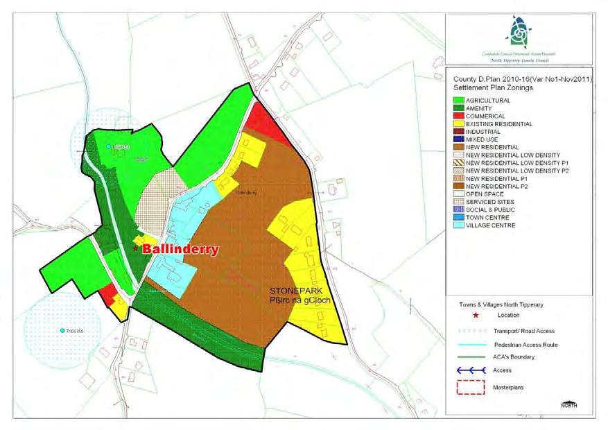
10 BALLINDERRY SETTLEMENT PLAN 30
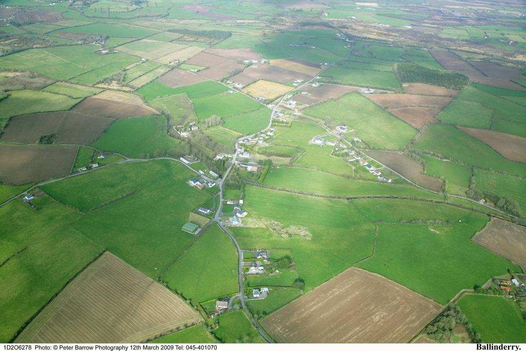
11 1.0 General Introduction and Development Context Location Ballinderry is located approximately 7km to the west of Borrisokane and 4km south of Terryglass on the R493. The village has formed around the Ballyfinboy River. Population Ballinderry is located predominantly in the Terryglass DED which had a population of 451 in This represented a decrease of 53 persons or 10.5% from A small portion of the village is within the Kilbarron DED which experienced a slight decrease in population. Settlement Form The village is linear in nature with some fine examples of historic buildings within the village most notably the village public house Elsie Hogans. The village has an attractive natural setting with landscaping and natural stone walls contributing to the visual amenity of the settlement. The bridge over the Ballyfinboy River marks the entrance to the village on its southern approach. Expansion within the village in recent decades has been very slow with existing permissions not having been realised. 2.0 Key Aim and Objectives The key aim of the settlement plan is to provide a framework for the development of residential, commercial and other appropriate development and to enhance the visual character and the amenities of the village. Key Objectives To facilitate low density, high quality housing appropriate to the village location to ensure adequate critical mass to maintain/improve local service provision. To provide, maintain and enhance social, community and amenity facilities within the village. To support opportunities for commercial and employment facilities. Cater for a number of small in-depth housing schemes, serviced sites developments and also commercial / employment generating development which is appropriate in terms of scale, use and location within the village. Contain development in order to enhance the village and its setting. 3.0 Services and Social Infrastructure Water Supply The village is serviced by a local group water supply. Waste Water The village is not served by the public sewer. 31


 and Elsie Hogans")
12 Developments within the village are served by individual on-site septic tanks and treatment systems. Roads and Transport Infrastructure. The village is served by a regional road and local roads which link the settlement to Borrisokane and the N52 and N65. There are no public footpaths on the local road. There is an existing network of public lighting within the settlement. Social and Community Infrastructure The village is served by a public house and a caravan park. There are no public footpaths on the regional road or on the local roads. There is an existing network of public lighting within the settlement. 4.0 Architectural and Archaeological Heritage There are a number of historic buildings and sites within the village boundaries. Significant buildings within the village which have been included on the Record of Protected Structures include the vast ruins of Ballinderry Mill, Mill Lodge (a former RIC barracks) and Elsie Hogans public house. The bridge over the Ballyfinboy river is also a significant structure in the village and frames the entrance to the village to the south. Ballinderry Mill in the village is also a recorded monument Elsie Hogans S 300 Ballinderry Mill S296 Ballinderry Bridge S
13 5.0 Key Messages for Ballinderry The settlement should be developed in a properly planned and co-ordinated manner in accordance with the zoning objectives of the settlement plan. Low density rural clustered style development is promoted on residential zoned sites. Promotion of low-density linear or clustered style development within the village, with the exception of slightly tighter knit development in the core. The conservation and integration into new development of existing stone walls, trees and native hedgerows, and promotion of similar materials for new boundaries. High quality designs, which are reflective of the existing rural character of the village, without precluding high quality innovative contemporary designs. Proposals for development will require provision to be made for on-site effluent treatment. This provision will be a key factor which will influence the scale and design of all developments. 6.0 General Development Objectives Proposals for development will be assessed in accordance with the policies and objectives of the County Development Plan, as set out in the main text in Volume 1. In addition to general policy requirements for development, the Council will seek to implement the following objectives: The Council will seek to make provision and/or facilitate the provision of footpaths and public lighting to enhance the local infrastructure. The provision of a public footpath is considered a particularly priority. The Council will seek to foster a village identity and definition of the village by facilitating the provision of hard and soft landscaping and signage. The Council will seek to ensure the protection of the protected structure and archaeological monument (i.e. by preservation in situ or at a minimum protection by record). The Council will seek to control ribbon development on the approach roads to preserve and consolidate the built environment of the village. The Council will seek to ensure hedgerows, trees and any natural stone walls are preserved and maintained in any new development proposals. Promotion of low-density linear or clustered style development within the village, with the exception of slightly tighter knit development in the core. 33
14 STAGE ONE FLOOD RISK ASSESSMENT - BALLINDERRY 1.0 Introduction This is the Stage 1 Flood Risk Identification for Variation No. 1 of the County Development Plan 2010 (hereafter referred to as the Plan), prepared in accordance with the Planning System and Flood Risk Management Guidelines for Planning Authorities published by the Department of the Environment, Heritage and Local Government and the OPW in November The purpose of this process is to identify whether there may be any flooding or surface water management issues related to the plan area that may warrant further investigation through stage 2 and 3 Flood Risk Assessment. This stage 1 Flood Risk Assessment forms an integral part of the SEA process for Variation of the Plan and will inform the approach to future planning and development in North Tipperary. 2.0 Flood Risk Identification (Stage 1) The following sources of information have been investigated in order to determine flood risk potential; 1. OPW preliminary Flood Risk Assessment indicative fluvial flood maps. 2. Predictive and historic flood maps, and benefiting land maps, such as those at 3. Predicative flood maps produced under the CFRAM. 4. River Basin Management Plans and reports. 5. Indicative assessment of existing flood risk under preliminary flood risk assessment. 6. Expert advice from OPW 7. Consultation with local authority 8. Topographical maps. 9. GSI Alluvial deposit map. 10. Liable to flood markings on the old 6 inch maps. 11. Newspaper reports. 12. Consultation with Local Community 13. Walkover survey Each of these sources is addressed individually below: 1. OPW preliminary Flood Risk Assessment indicative fluvial flood maps. These are being produced through the catchment-based Flood Risk Assessment and Management Study. These maps are not yet available for the River Shannon Catchment. 2. Predictive and historic flood maps, and benefiting land maps, such as those at This website was consulted. It was found that there were no recorded flood events in the village of Ballinderry. 3. Predicative flood maps produced under the CFRAM. The Shannon Catchment Flood Risk and Management Study (CFRAM) is to be commenced in 2010 and is scheduled to be completed by the end of Therefore the predicative flood maps to be prepared under this project are not yet available. 4. Catchment Flood Risk Assessment and Management Plans and reports. The Shannon Catchment Flood Risk and Management Study (CFRAM) is to be commenced in 2010 and is scheduled to be completed by the end of Therefore this Stage 1 Flood Risk 34

15 Assessment has not been able to make reference to any guidance or information which may be contained within it. It is hoped that as part of the review of the Plan, to be completed by 2013 that this information will be available and can feed into the Assessment for the new Plan. 5. Indicative assessment of existing flood risk It is noted that the OPW has no recorded flood events in and around the village. 6. Expert advice from OPW This Stage 1 Flood Risk has been undertaken with the advantage of expert advice from the OPW. 7. Consultation with local authority A site visit was undertaken and planning histories consulted. There is no evidence of flooding history. 8. Topographical maps. County Topographical maps do not adequately address the local Ballinderry area as they are based on the topography of the county. 9. GSI Alluvial deposit map. GSI Soils Map for Ballinderry The GSI Soils map is set out above for Ballinderry. The yellow/mustard area represents that area where alluvial soils have been historically deposited. Alluvial soil mapping alone is not a definitive gauge of areas at flood risk, however, it a useful indicator of areas where flood events have occurred historically. The GSI Soils Map has informed the Land Use Zoning Map and areas 35
16 which are potentially liable to flooding have been zoned for amenity uses (save where they have already been developed. 10. Liable to flood markings on the old 6 inch maps. None of the lands within the village or adjacent to the river, within the settlement boundary have been identified on the 6 maps as being liable to flooding. 11. Newspaper reports The Newspaper Reports available at were consulted as part of this Stage 1 Flood Risk Assessment. There was no record of reports of flooding in the village. 12. Consultation with local people. Consideration will be given to any comments received during the public consultation phase on the Development Plan that relate to flooding in the area. 13. Walkover survey to assess potential sources of flooding. A number of inspections were carried out on site by the Planning Officer during the preparation of the Variation. 3.0 Conclusion This is the Stage 1 Flood risk assessment for Variation No. 1 to the County Development Plan The Planning Authority is satisfied that there is no potential flood risk identified in areas planned for growth in Ballinderry based on an assessment of all the sources listed above and bearing in mind a precautionary approach. This report should be read in conjunction with the SEA and HDA Report documentation as part of the variation process. It is concluded that there will be no significant flood risk to the Plan area and any surrounding areas as a result of Variation No. 1 to the County Development Plan
17 BALLYINGARRY SETTLEMENT PLAN
18 1.0 General Introduction and Development Context Location It located on the N52, approximately half way between Borrisokane and Birr. Population Ballingarry has a population of 574 people (2006 Census) much of which is dispersed outside the settlement. This is a decrease from 583 in the 2002 Census. Settlement Form The village is dominated by the N52 which runs through it. The built settlement is formed around two local roads which join the N52 in the village. While the settlement has suffered the loss of its petrol station in recent years, it is the base for two significant companies. To facilitate low density, high quality housing appropriate to the village location. To maintain and enhance social, community and amenity facilities within the village. To support opportunities for commercial and employment facilities. To encourage the consolidation of the village around the existing crossroads. 3.0 Services and Social Infrastructure Water Supply Ballingarry is served by a public water supply. Waste Water The village is not served by the public sewer. Developments within the village are served by individual on-site septic tanks and treatment systems. Roads and Transport Infrastructure The village is bisected by the N52, with the local road, L-1074 to the west and L to the east. Approach roads to the villages are of a high amenity quality and are well maintained. 2.0 Key aim and objectives The key aim of the settlement plan is to provide a framework for the development for appropriate residential, commercial and light industrial development and to enhance the visual character and amenities of the village. Key Objectives There are existing public footpaths within the village and there is a limited network of public lighting. Social and Community Infrastructure The village shop and filling station has been closed, but the shop and pumps are still in place and could be opened again. There are two public houses, a community hall and GAA grounds with large hall. On

19 the eastern edge of the village there is a Church of Ireland Church. The Catholic Church is located at the Pike Cross Roads approximately 1 mile to the east of the village. The Community have created an amenity area along Church Lane and there is a unique opportunity to identify a looped walk around the village within the Plan. 4.0 Architectural and Archaeological Heritage There are a number of significant historical sites within the village. These include; Ballingarry Castle (in ruins) is located to the east side of the village Tower House Site Church and Graveyard Bee-Boles In the bawn of Ballingarry castle on a south-facing wall are 18 arched recessed arches, known as bee boles. Only a dozen or so of these rare 16th bee boles are recorded in Ireland. In these recesses or boles were placed the straw beehives or skeps. The boles are in three tiers, the lowest 18 inches off the ground, the highest 9 ft. They are believed to have been in use until the last century. Bees have always been important in the Irish rural economy. 5.0 Key Messages for Ballingarry The settlement should be developed in a properly planned and co-ordinated manner in accordance with the zoning objectives of the settlement plan. Low density rural clustered style development is promoted on residential zoned sites. Proposals for development will require provision to be made for on-site effluent treatment. This provision will be a key factor which will influence the scale and design of developments. Development should contribute towards the consolidation of the village centre around the existing junctions. Re-opening of the shop and petrol station would enhance the quality of life within the village. 6.0 General Development Objectives Proposals for development will be assessed in accordance with the policies and objectives of the County Development Plan, as set out in the main text in Volume 1. In addition to general policy requirements for development, the Council will seek to implement the following objectives: The Council will seek to make provision and/or facilitate the provision of footpaths and public lighting to enhance the local infrastructure. The Council will seek to foster a village identity and definition of the village by facilitating the provision of hard and soft landscaping and signage. The Council will seek to ensure the protection of Protected Structures and archaeological monument (i.e. by preservation
20 in situ or at a minimum protection by record). The Council will seek to control ribbon development on the approach roads to preserve and consolidate the built environment of the village. The Council will seek to ensure hedgerows, trees and any natural stone walls are preserved and maintained in any new development proposals. The Council will seek to continue to improve the approach roads to the village and improve traffic calming. The Council will seek to ensure that development is focused within the village around the core area so as to consolidate the centre of the village. The Council will seek to develop a looped walk around the village, identified on the zoning map.
21 BALLYCAHILL SETTLEMENT PLAN
22 1.0 General Introduction and Development Context Location Ballycahill is located on the R-503 regional road c. 5km west of Thurles. Population Ballycahill is located in the district electoral division of Ballycahill, which has experienced a population decline during the inter-censal period of 13% (from persons). During the period the population declined further by 3 people (CSO, 2006). Settlement Form The settlement has developed in a linear pattern running along the regional road and in a southern axis from the crossroads. The village is characterised by the two thatched properties which abut the crossroad and the centrally located village green. 2.0 Key aim and objectives The key aim of the settlement plan is provide a framework for the development for appropriate residential, commercial and light industrial development and to enhance the visual character and amenities of the village. Key Objectives To facilitate low density, high quality housing appropriate to the village location. To maintain and enhance social, community and amenity facilities within the village. To support opportunities for commercial and employment facilities. 3.0 Services and Social Infrastructure Water Supply The village is serviced by a public water supply. Waste Water The village is not served by a public wastewater treatment plant. Developments within the village are served by individual on-site septic tanks and treatment systems.
23 Roads and Transport Infrastructure The village is on a key regional transport route linking Thurles to Limerick, the R There is a limited network of footpaths and public lighting within the village. Social and Community Infrastructure The village is served by a church, public house, community hall, school and playing field. 4.0 Architectural and Archaeological Heritage The thatched house at the regional road junction is listed on the record of protected structures under Volume III of the Plan. There are also a number of recorded monuments to the west of the village, including includes a fortified church and graveyard. 5.0 Key Messages for Ballycahill The settlement should be developed in a properly planned and co-ordinated manner in accordance with the zoning objectives of the settlement plan. Low density rural clustered style development is promoted on residential zoned sites. Proposals for development will require provision to be made for on-site effluent treatment. This provision will be a key factor which will influence the scale and design of developments. 6.0 General Development Objectives Proposals for development will be assessed in accordance with the policies and objectives of the County Development Plan, as set out in the main text in Volume 1. In addition to general policy requirements for development, the Council will seek to implement the following objectives: The Council will seek to make provision and/or facilitate the provision of footpaths and public lighting to enhance the local infrastructure. The Council will seek to foster a village identity and definition of the village by facilitating the provision of hard and soft landscaping and signage. The Council will seek to ensure the protection of protected structures and archaeological monument (i.e by preservation in situ or at a minimum protection by record). The Council will seek to control ribbon development on the approach roads to preserve and consolidate the built environment of the village. The Council will seek to ensure hedgerows, trees and any natural stone walls are preserved and maintained in any new development proposals.
24 BALLYCOMMON SETTLEMENT PLAN

25 1.0 General Introduction and Development Context Location Ballycommon is a small village approximately 3km outside Nenagh on the road to Dromineer. Settlement Form The settlement at Ballycommon is very traditional in origin, given its location at a junction in the road network. The village has seen some development in recent years, and it is likely that the village will grow into the future given its location close to Nenagh. 3.0 Services and Social Infrastructure Water Supply The village is serviced by a public water supply. Waste Water Historically the village has been served by individual treatment systems. A recent residential development has provided a treatment plant capable to treat effluent from the village. It si desirable that future development in the village take place through connections to a communal treatment plant. Roads and Transport Infrastructure The village is located at the crossroads of the Regional Road (R-495) and Local Roads (L-1021 and L-1022). 2.0 Key aim and objectives The key aim of the settlement plan is provide a framework for the development for appropriate residential and commercial development and to enhance the visual character and amenities of the village. Key Objectives To maximise the tourism opportunities within the village. To facilitate low density, high quality housing appropriate to the village location. To maintain and enhance social, community and amenity facilities within the village. To support opportunities for commercial and employment facilities. There are currently no public footpaths in the area. Public lighting is provided throughout the settlement. Social and Community Infrastructure The village has a public house, shop/filling station, and community hall. 4.0 Key Messages for Ballycommon The settlement should be developed in a properly planned and co-ordinated manner in accordance with the zoning objectives of the settlement plan. Low density rural clustered style development is promoted on residential zoned sites. Derelict sites within the village should be a focus for redevelopment.
26 The conservation and integration into new development of existing stone walls, trees and native hedgerows, and promotion of similar materials for new boundaries. High quality designs, which are particularly reflective of the predominantly rural character of the area, without precluding high quality innovative contemporary designs. 5.0 General Development Objectives Proposals for development will be assessed in accordance with the policies and objectives of the County Development Plan, as set out in the main text in Volume 1. In addition to general policy requirements for development, the Council will seek to implement the following objectives: The Council will seek to make provision and/or facilitate the provision of footpaths and public lighting to enhance the local infrastructure. The Council will seek to foster a village identity and definition of the village by facilitating the provision of hard and soft landscaping and signage. The Council will seek to control ribbon development on the approach roads to preserve and consolidate the built environment of the village. The Council will seek to ensure hedgerows, trees and any natural stone walls are preserved and maintained in any new development proposals. The Council will seek to continue to improve the approach roads to the village and improve traffic calming.
27 B ALLYMACKEY/BALLINREE SETTLEMENT PLAN
28 Ballinree 1.0 General Introduction and Development Context Location The village of Ballymackey mid-way between Nenagh and Toomevara and north of the N7. Settlement Form The upper village (Ballymackey) and the lower village (Ballinree) are separated by circa 1 km but are reasonably well defined where little development has taken place between both. 2.0 Key aim and objectives The key aim of the settlement plan is to provide a framework for the development for appropriate residential, commercial and light industrial development and to enhance the visual character and amenities of the village. Key Objectives To facilitate low density, high quality housing appropriate to the village location. To maintain and enhance social, community and amenity facilities within the village. To support opportunities for commercial and employment facilities. 3.0 Services and Social Infrastructure Water Supply The village is serviced by a public water supply.


29 Waste Water The village is not serviced by public waste waster treatment system. Developments within the village are served by individual on-site septic tanks and treatment systems. Roads and Transport Infrastructure The settlement is served by a local road network. However, the village is located close to strategic route corridor of the N7, the lower village will be located just north of the new M7. There are no footpaths or public lighting in the upper or lower village. Social and Community Infrastructure The settlement is served by a shop, public house, sports field and garda station. Ballinree RC Chruch, a detached gable fronted church built c St. Michaels Church The Rectory 4.0 Architectural and Archaeological Heritage There a number of structure of architectural importance in the village including: St. Michael Church of Ireland Church, which detached singlecell church built c and while ruined contributes significantly to the heritage and amenity of the area. The former rectory/curates house, is a detached L-plan two story dwelling which was built c The walled garden is still in use, and the house is complemented by its outbuildings. Ballinree Roman Catholic Church TI Ballymackey Church (in ruins) and Graveyard, The Church was a
30 building used for public Christian worship. These can be of any date from c. 500 AD onwards and the graveyard associated with it. 5.0 Key Messages for Ballymackey/Ballinree The settlement should be developed in a properly planned and co-ordinated manner in accordance with the zoning objectives of the settlement plan. Low density rural clustered style development is promoted on residential zoned sites. Proposals for development will require provision to be made for on-site effluent treatment. This provision will be a key factor which will influence the scale and design of developments. The Council will seek to ensure the protection of the protected structure and archaeological monument (i.e by preservation in situ or at a minimum protection by record). The Council will seek to control ribbon development on the approach roads to preserve and consolidate the built environment of the village. The Council will seek to ensure hedgerows, trees and any natural stone walls are preserved and maintained in any new development proposals. 6.0 General Development Objectives Proposals for development will be assessed in accordance with the policies and objectives of the County Development Plan, as set out in the main text in Volume 1. In addition to general policy requirements for development, the Council will seek to implement the following objectives: The Council will seek to make provision and/or facilitate the provision of footpaths and public lighting to enhance the local infrastructure. The Council will seek to foster a village identity and definition of the village by facilitating the provision of hard and soft landscaping and signage.
31 BALLINACLOUGH SETTLEMENT PLAN
32 1.0 General Introduction and Development Context Location Ballinaclough is located c. 6km south of Nenagh. Population The village is located the D.E.D of Ballinaclough. The population of Ballinaclough (DED) is 654 persons, an increase of 5.1% since 1996 (CSO, 1996). Settlement Form The village is characterised by its picturesque setting afforded by its location on the Nenagh River and the presence of a number of structure of archaeological and architectural significance. To facilitate low density, high quality housing appropriate to the village location. To maintain and enhance social, community and amenity facilities within the village. To support opportunities for commercial and employment facilities. 3.0 Services and Social Infrastructure Water Supply The village is serviced by a public water supply. Waste Water The village is not served by the public sewer. Developments within the village are served by individual on-site septic tanks and treatment systems. Roads and Transport Infrastructure 2.0 Key aim and objectives The key aim of the settlement plan is to provide a framework for the development for appropriate residential and commercial development and to enhance the visual character and amenities of the village. Key Objectives To maintain and protect the Architectural and Archaeological heritage of the area. The area is served by a local road network. However, given its relative proximity to Nenagh is close to key strategic road transport corridors. There are no public footpaths and a limited network of public lighting. Social and Community Infrastructure The village provide little local service provision, with the local school an RC church located in the rural hinterland. 4.0 Architectural and Archaeological Heritage

33 The settlement has a strong historical legacy and is one of two medieval manors established in the 12 th century to support the Anglo-Norman Butler family in Nenagh. There are a number of recorded monuments located within the settlement. There are also a number of buildings within the settlement which are listed on the record of protected structures under Volume III of the Plan. There include Ballinnaclough House and the bridge over the Nenagh River. Bridge S692 Low density rural clustered style development is promoted on residential zoned sites. Development proposed should have particular regarded to the architectural heritage of the area. Proposals for development will require provision to be made for onsite effluent treatment. This provision will be a key factor which will influence the scale and design of developments. 6.0 General Development Objectives Proposals for development will be assessed in accordance with the policies and objectives of the County Development Plan, as set out in the main text in Volume 1. In addition to general policy requirements for development, the Council will seek to implement the following objectives: Church S Key Messages for Ballinaclough The settlement should be developed in a properly planned and coordinated manner in accordance with the zoning objectives of the settlement plan. The Council will seek to make provision and/or facilitate the provision of footpaths and public lighting to enhance the local infrastructure. The Council will seek to foster a village identity and definition of the village by facilitating the provision of hard and soft landscaping and signage. The Council will seek to ensure the protection of the protected structure and archaeological monument (i.e by preservation in situ or at a minimum protection by record). The Council will seek to control ribbon development on the approach roads to preserve and consolidate the built environment of the village.
34 The Council will seek to ensure hedgerows, trees and any natural stone walls are preserved and maintained in any new development proposals.
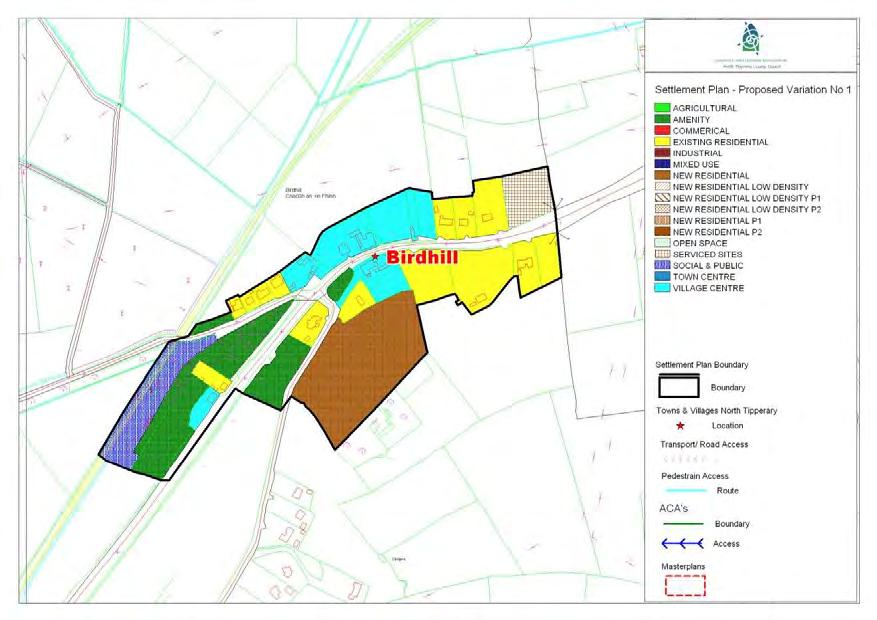
35 BIRDHILL SETTLEMENT PLAN 48
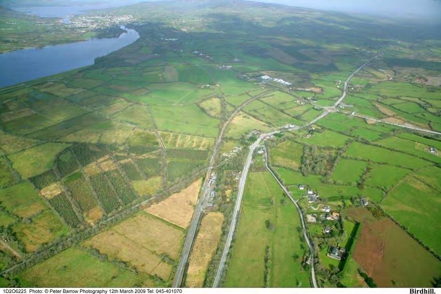
36 1.0 General Introduction and Development Context Location The village of Birdhill is located mid-way between Limerick City (20km) and Nenagh Town (19km). Ballina/Killaloe is situated c. 5km to the north west while Newport is situated c. 6km to the south west. Population Birdhill is located in the Birdhill DED and had a population of 671 in This represented an increase of 83 persons or 14.1% from Settlement Form Birdhill has predominantly a linear shape, the central core of the village has developed along the R445 (former N7) and from there the village expanded outwards along the routes of the Newport road R504, the R494 (Ballina Road) and the R466 (Coosane/Shannon Crossing). The village core unlike most traditional villages is not formed by a street but rather a series of detached buildings with a mix of residential and commercial units. It is noteworthy that the built fabric of the village core has not altered significantly over the past 100 years, as illustrated by the historical and most recent ordinance survey maps of the settlements. 2.0 Key Aim and Objectives The key aim of the settlement plan is to provide a framework for the development of residential, commercial and other appropriate development and to enhance the visual character and amenities of the village. Key Objectives To facilitate low density, high quality housing appropriate to the village location to ensure adequate critical mass to maintain/improve local service provision. To provide, maintain and enhance social, community and amenity facilities within the village. To support opportunities for commercial and employment facilities. Cater for a number of small in-depth housing schemes, serviced sites developments and also commercial / employment generating development which is appropriate in terms of scale, use and location within the village. Consolidate development within the delineated village boundary in order to protect the area of high amenity within which the village is set. Foster the creation of a more coherent settlement, with adequate critical mass to maintain/improve local service provision. 3.0 Services and Social Infrastructure Water Supply The village is serviced by a public water supply. Waste Water The village is not served by the public sewer. Developments within the village are served by individual on-site septic tanks and treatment systems. 49


37 Roads and Transport Infrastructure. The new M7, which has recently been opened bypasses the village and will reduce travel times to nearby towns, including the primary service centres of Limerick and Nenagh. The opening of the motorway presents a number of advantages for the settlement, including increased traffic and pedestrian safety, reduced noise and pollution. The village has a key advantage in being located on the Limerick-Ballybrophy-Dublin railway line which provides daily services. Public footpaths are evident within the village and there is an existing network of public lighting within the settlement. Social and Community Infrastructure The village is served by a public house, pub/restaurant and furniture store. 4.0 Architectural and Archaeological Heritage There are a number of historic buildings and sites within the village boundaries. Significant buildings within the village considered worthy of protection and other buildings/features of note in and around the village are illustrated below. Browser s Furniture Company - S 711 Matt The Threshers S 712 Birdhill Railway Station - S
38 5.0 Key Messages for Birdhill The settlement should be developed in a properly planned and co-ordinated manner in accordance with the zoning objectives of the settlement plan. Low density rural clustered style development is promoted on residential zoned sites. Promotion of low-density linear or clustered style development within the village, with the exception of slightly tighter knit development in the core. The conservation and integration into new development of existing stone walls, trees and native hedgerows, and promotion of similar materials for new boundaries. High quality designs, which are reflective of the existing rural character of the village, without precluding high quality innovative contemporary designs. Proposals for development will require provision to be made for on-site effluent treatment. This provision will be a key factor which will influence the scale and design of all developments. 6.0 General Development Objectives Proposals for development will be assessed in accordance with the policies and objectives of the County Development Plan, as set out in the main text in Volume 1. In addition to general policy requirements for development, the Council will seek to implement the following objectives: The Council will seek to improve and extend the provision of footpaths and public lighting to enhance the local infrastructure. The Council will seek to foster a village identity and definition of the village by facilitating the provision of hard and soft landscaping and signage. A traditional streetscape which maintains where possible the front boundary wall and trees. The Council will seek to ensure hedgerows, trees and any natural stone walls are preserved and maintained in any new development proposals. Promotion of low-density linear or clustered style development within the village, with the exception of slightly tighter knit development in the core. Buildings which respect the scale, massing and design of existing buildings in the village. The Council will seek to ensure the protection of protected structures. The Council will seek to control ribbon development on the approach roads to preserve and consolidate the built environment of the village. The creation of a civic space, designed for active public use. Protection of public vistas to Lough Derg. Retention of Existing Structures on the sites where appropriate. Landscaping of native species and incorporating flower beds indicative of the area. All developments within the village shall have due regard to the Birdhill Village Design Statement. 51
39 STAGE ONE FLOOD RISK ASSESSMENT - BIRDHILL 1.0 Introduction This is the Stage 1 Flood Risk Identification for Variation No. 1 of the County Development Plan 2010 (hereafter referred to as the Plan), prepared in accordance with the Planning System and Flood Risk Management Guidelines for Planning Authorities published by the Department of the Environment, Heritage and Local Government and the OPW in November The purpose of this process is to identify whether there may be any flooding or surface water management issues related to the plan area that may warrant further investigation through stage 2 and 3 Flood Risk Assessment. This stage 1 Flood Risk Assessment forms an integral part of the SEA process for Variation of the Plan and will inform the approach to future planning and development in North Tipperary. 2.0 Flood Risk Identification (Stage 1) The following sources of information have been investigated in order to determine flood risk potential; 1. OPW preliminary Flood Risk Assessment indicative fluvial flood maps. 2. Predictive and historic flood maps, and benefiting land maps, such as those at 3. Predicative flood maps produced under the CFRAM. 4. River Basin Management Plans and reports. 5. Indicative assessment of existing flood risk under preliminary flood risk assessment. 6. Expert advice from OPW 7. Consultation with local authority 8. Topographical maps. 9. GSI Alluvial deposit map. 10. Liable to flood markings on the old 6 inch maps. 11. Newspaper reports. 12. Consultation with Local Community 13. Walkover survey Each of these sources is addressed individually below: 1. OPW preliminary Flood Risk Assessment indicative fluvial flood maps. These are being produced through the catchment-based Flood Risk Assessment and Management Study. These maps are not yet available for the River Shannon Catchment. 2. Predictive and historic flood maps, and benefiting land maps, such as those at This website was consulted. It was found that there were no recorded flood events in the village of Birdhill. 3. Predicative flood maps produced under the CFRAM. The Shannon Catchment Flood Risk and Management Study (CFRAM) is to be commenced in 2010 and is scheduled to be completed by the end of Therefore the predicative flood maps to be prepared under this project are not yet available. 4. Catchment Flood Risk Assessment and Management Plans and reports. The Shannon Catchment Flood Risk and Management Study (CFRAM) is to be commenced in 2010 and is scheduled to be completed by the end of Therefore this Stage 1 Flood Risk 52

40 Assessment has not been able to make reference to any guidance or information which may be contained within it. It is hoped that as part of the review of the Plan, to be completed by 2013 that this information will be available and can feed into the Assessment for the new Plan. 5. Indicative assessment of existing flood risk There is no river flowing through Birdhill village and the topography is such that the land falls from the south east to north west direction. A recorded flood event took place on the Shannon Callows in January This land is at a substantially lower level to the village itself. It is noted that the OPW has no recorded flood events in the village. 6. Expert advice from OPW This Stage 1 Flood Risk has been undertaken with the advantage of expert advice from the OPW. 7. Consultation with local authority A site visit was undertaken and planning histories consulted. There is no evidence of flooding history. 8. Topographical maps. County Topographical maps do not adequately address the local Birdhill area as they are based on the topography of the county. 9. GSI Alluvial deposit map. GSI Soils Map for Birdhill The GSI Soils map is set out above for Birdhill. The red area represents that area where Acid Brown Earths Brown Podzolics soils are in existence. The GSI Soils Map has informed the Land Use Zoning Map. 10. Liable to flood markings on the old 6 inch maps. None of the lands within the village or adjacent to the river, within the settlement boundary have been identified on the 6 maps as being liable to flooding. 53
41 11. Newspaper reports The Newspaper Reports available at were consulted as part of this Stage 1 Flood Risk Assessment. There was no record of reports of flooding in the village. 12. Consultation with local people. Consideration will be given to any comments received during the public consultation phase on the 2010 Development Plan variation that relate to flooding in the area. 13. Walkover survey to assess potential sources of flooding. A number of inspections were carried out on site by the Planning Officer during the preparation of the Variation. 3.0 Conclusion This is the Stage 1 Flood risk assessment for Variation No. 1 to the County Development Plan The Planning Authority is satisfied that there is no potential flood risk identified in areas planned for growth in Birdhill based on an assessment of all the sources listed above and bearing in mind a precautionary approach. This report should be read in conjunction with the SEA and HDA documentation prepared as part of the variation process. It is concluded that there will be no significant flood risk to the Plan area and any surrounding areas as a result of Variation No. 1 to the County Development Plan
42 CARRIG SETTLEMENT PLAN
43 1.0 General Introduction and Development Context Location Carrig is a small village which has developed around the small river which runs through it and junction of the N52 with local road L Population The settlement of Carrig has a population of 188 people (CSO, 2006) up from 186 people in the 2002 Census. Settlement Form The built settlement is formed by a cluster of buildings, centred on either side of the river. The village is linear in nature and is dominated by the N52 which runs through it. Key Objectives To facilitate low density, high quality housing appropriate to the village location. To maintain and enhance social, community and amenity facilities within the village. To support opportunities for commercial and employment facilities. 3.0 Services and Social Infrastructure Water Supply The village is serviced by a public water supply. Waste Water The village is not served by the public sewer. Developments within the village are served by individual on-site septic tanks and treatment systems. Roads and Transport Infrastructure The settlement is strategically located on the N52 approximately half way between Ballngarry and Birr. There are no public footpaths within the village and there is a limited network of public lighting. 2.0 Key aim and objectives The key aim of the settlement plan is provide a framework for the development for appropriate residential and commercial development and to enhance the visual character and amenities of the village. Social and Community Infrastructure The settlement is served by a shop with a filling station, a church, public house, a community hall and there is a sports field located 0.4km outside the village.
 Carrig Windmill (in ruins) on-site effluent treatment. This provision will be a key factor which will influence the scale and design of developments. 6.")

44 4.0 Architectural and Archaeological Heritage There are a number of significant historical sites within the village. These include; Carrig castle (site of) Carrig Windmill (in ruins) on-site effluent treatment. This provision will be a key factor which will influence the scale and design of developments. 6.0 General Development Objectives Proposals for development will be assessed in accordance with the policies and objectives of the County Development Plan, as set out in the main text in Volume 1. In addition to general policy requirements for development, the Council will seek to implement the following objectives: 5.0 Key Messages for Carrig The settlement should be developed in a properly planned and co-ordinated manner in accordance with the zoning objectives of the settlement plan. Low density rural clustered style development is promoted on residential zoned sites. The river which runs through the village provides an opportunity to extending the amenity area and provide a river walk. Development in the vicinity should seek to ensure its amenity value is enhanced and protected. Proposals for development will require provision to be made for The Council will seek to make provision and/or facilitate the provision of footpaths and public lighting to enhance the local infrastructure. The Council will seek to foster a village identity and definition of the village by facilitating the provision of hard and soft landscaping and signage. The Council will seek to ensure the protection of Protected Structures and archaeological monument (i.e by preservation in situ or at a minimum protection by record). The Council will seek to control ribbon development on the approach roads to preserve and consolidate the built environment of the village. The Council will seek to ensure hedgerows, trees and any natural stone walls are preserved and maintained in any new development proposals. The Council will seek to continue to improve the approach roads to the village and improve traffic calming.
45 CARRIGAHORIG SETTLEMENT PLAN
46 1.0 General Introduction and Development Context Location The village of Carrigahorig is located in the north of the County c. 30km north of Nenagh. The N65 to Portumna runs through it, and the R493 to Terryglass lies to its south. The village is situated within 2km of the eastern shore of Lough Derg on a picturesque river with a small waterfall. Population Carrigahorig is located in the D.E.D. of Terryglass and has a population of 451. The population has decreased by 53 people between (CSO, 2006). Settlement Form The built settlement is formed by a cluster of buildings, centred on either side of the river. The village is small in nature and is dominated by the 90 degree bend on the N65 which lies in the centre of the village. The village community have developed and maintained an attractive riverside park within the village, focused on the waterfall. This provides a focal point for the village. 2.0 Key aim and objectives The key aim of the settlement plan is to provide a framework for the development for appropriate residential and commercial development and to enhance the visual character and amenities of the village. Key Objectives To facilitate low density, high quality housing appropriate to the village location. To maintain and enhance social, community and amenity facilities within the village. To support opportunities for commercial and employment facilities. To focus development around the core of the village. 3.0 Services and Social Infrastructure Water Supply The village is serviced by a public water supply. Waste Water The village is not served by the public sewer. Developments within the village are served by individual on-site septic tanks and treatment systems. Roads and Transport Infrastructure The village is well serviced by key transport links, located at the junction of national secondary road N65 (Borrisokane/Portumna Road) and regional road R493 to Terryglass. There are no recognisable public footpaths in the area. Public lighting is provided within the settlement. Social and Community Infrastructure The village centre provides a selection of services such as a post office, a shop and a public house. There are a small number of residences within the village. 4.0 Key Messages for Carrigahorig The settlement should be developed in a properly planned and co-ordinated manner in
47 accordance with the zoning objectives of the settlement plan. Low density rural clustered style development is promoted on residential zoned sites. Development in the vicinity of the amenity area and the river should seek to ensure its value to the community is enhanced and protected. Proposals for development will require provision to be made for on-site effluent treatment. This provision will be a key factor which will influence the scale and design of developments. The Council will seek to continue to improve the approach roads to the village and improve traffic calming. The Council will seek to ensure that development is focused within the village around the core area so as to consolidate the centre of the village. The Council will seek the redevelopment of derelict sites within the village. 5.0 General Development Objectives Proposals for development will be assessed in accordance with the policies and objectives of the County Development Plan, as set out in the main text in Volume 1. In addition to general policy requirements for development, the Council will seek to implement the following objectives: The Council will seek to make provision and/or facilitate the provision of footpaths and public lighting to enhance the local infrastructure. The Council will seek to foster a village identity and definition of the village by facilitating the provision of hard and soft The Council will seek to control ribbon development on the approach roads to preserve and consolidate the built environment of the village. The Council will seek to ensure hedgerows, trees and any natural stone walls are preserved and maintained in any new development proposals.
48 CASTLEINEY SETTLEMENT PLAN
.")

49 1.0 General Introduction and Development Context Location Castleiney is a small located c. 5km east of Templemore. The village is sometimes known locally as Washpen. Population Casttleiney is located within the DED of Templetouhy which had a population of 837 in This represented a decrease of 16 since 2002 (CSO, 2006). Settlement Form The is a clustered settlement which has developed around the local road crossroads. New development has built up in a linear pattern to the east of the crossroads. 2.0 Aim and Objectives The key aim of the settlement plan is to provide a framework for the development for appropriate residential, commercial and light industrial development and to enhance the visual character and amenities of the village. Key Objectives To facilitate low density, high quality housing appropriate to the village location. To maintain and enhance social, community and amenity facilities within the village. To support the provision of a local shop to serve the settlement and its hinterland. To support opportunities for commercial and employment facilities. 3.0 Services and Social Infrastructure Water Supply The village is serviced by a public water supply. Waste Water A public wastewater treatment plant does not serve the village. Developments within the village are served by individual on-site septic tanks and treatment systems. Roads and Transport Infrastructure The village is served by a network of local roads, linking to the R-502 to the north. There are no public footpaths within the settlement and a limited network of public lighting. Social and Community Infrastructure The village is served by a church, parish hall, school, shop and FAS office. 4.0 Architectural Heritage The RC Church and 1930s handball alley are protected structures under the plan proposed protected structures. Castleiney RC Church S702 Handball Alley S704
50 Full record of protected structures is contained in Volume III of the Plan. 5.0 Key messages for Caslteleiny The settlement should be developed in a properly planned and co-ordinated manner in accordance with the zoning objectives of the settlement plan. Low density rural clustered style development is promoted on residential zoned sites. The river provides an opportunity to create a passive amenity area and development in the vicinity should ensure this amenity value is preserved and enhanced. Proposals for development will require provision to be made for on-site effluent treatment. This provision will be a key factor which will influence the scale and design of developments. 6.0 General Development Objectives Proposals for development will be assessed in accordance with the policies and objectives of the County Development Plan, as set out in the main text in Volume 1. In addition to general policy requirements for development, the Council will seek to implement the following objectives: The Council will seek to make provision and/or facilitate the provision of footpaths and public lighting to enhance the local infrastructure. The Council will seek to foster a village identity and definition of the village by facilitating the provision of hard and soft landscaping and signage. The Council will seek to ensure the protection of the protected structures. The Council will seek to control ribbon development on the approach roads to preserve and consolidate the built environment of the village. The Council will seek the provision of play areas in new residential developments.
51 CLONAKENNY SETTLEMENT PLAN
52 1.0 General Introduction and Development Context development and to enhance the visual character and amenities of the village. Location Clonakenny is a small settlement located c. 7km south east of Dunkerrin. Population The village is located within the DED of Bourney West. The population was 371 in 2006, which represented a decrease of 12 people since 2002 (CSO, 2006). Settlement Form The village has a dispersed settlement pattern, with no defined streetscape. However, the village has a rich historical heritage and the archaeological monuments at the south of the settlement, the church and vernacular buildings contribute to the traditional village character. The natural environment of the village has been greatly enhanced by the development of incidental amenity areas and landscaping and the approach roads are particularly characterised by natural stone walls. 2.0 Aim and Objectives Key Objectives To facilitate low density, high quality housing appropriate to the village location. To maintain and enhance social, community and amenity facilities within the village. To support the provision of a local shop to serve the settlement and its hinterland. To support opportunities for commercial and employment facilities. 3.0 Services and Social Infrastructure Water Supply The village is serviced by a public water supply. Waste Water The village is not served by a public wastewater treatment plant. Developments within the village are served by individual on-site septic tanks and treatment systems. The key aim of the settlement plan is to provide a framework for the development for appropriate residential, commercial and light industrial


53 Roads and Transport Infrastructure The village is served by a network of local roads, linking north to the N7 and to Templemore to the south. There is a limited network of footpaths and public lighting within the settlement. Social and Community Infrastructure The village is served by a public house and church. There is a fully equipped playground and picnic area, which was recently developed to the south of the settlement near Castlepark estate. Clonakenny G.A.A. grounds are located to the c. 1km north of the settlement at Corriga. 4.0 Architectural and Archaeological Heritage St. Bridget s RC Church (S-663) built in 1899, a focal building in the village is a proposed protected structure under Draft Plan. St. Bridget s RC Church (S-663) The local pub a building dating to c is also proposed for protection. There are a number of recorded archaeological monuments at the south edge of the settlement including a church, which dates back to early Christian times (TN ) and a Fortified House and walled bawn dating back to the 1500s. (TN /02). Full record of protected structures is contained in Volume III of the Plan. 5.0 Key Messages for Clonakenny The settlement should be developed in a properly planned and co-ordinated manner in accordance with the zoning objectives of the settlement plan. Low density rural clustered style development is promoted on residential zoned sites. The expansion of local services to particular include a local shop is promoted. The amenity areas should be maintained and an opportunity is provided to provide an additional river amenity area at the northern boundary. Proposals for development will require provision to be made for on-site effluent treatment. This provision will be a key factor, which will influence the scale and design of developments.
54 6.0 General Development Objectives Proposals for development will be assessed in accordance with the policies and objectives of the County Development Plan, as set out in the main text in Volume 1. In addition to general policy requirements for development, the Council will seek to implement the following objectives: The Council will seek to make provision and/or facilitate the provision of footpaths and public lighting to enhance the local infrastructure. It is a specific objective to make provision for a footpath should be made to provide a pedestrian link to the playground. The Council will seek the preservation of existing stone walls and natural hedgerows within development proposals. The Council will seek to ensure the protection of the protected structure and archaeological monuments (i.e by preservation in situ or at a minimum protection by record). The Council will seek to control ribbon development on the approach roads to preserve and consolidate the built environment of the village. The Council will seek to ensure hedgerows and trees are preserved, particularly on land abutting the river.
55 CLONMORE SETTLEMENT PLAN
56 1.0 General Introduction and Development Context Location Clonmore is located 5km northeast of Templemore Town on the regional road R-433 linking Templemore and Rathdowney. Population The settlement is located within the DED of Killavinoge. The population in 2006 was 405, the exact number which existed in 2002 (CSO, 2006). Settlement Form The village has a predominantly linear pattern, with development largely located along the local road running north. The natural centre point of the village is defined by the cluster of community buildings, which includes the church, pub and community centre. 2.0 Aim and Objectives The key aim of the settlement plan is to provide a framework for the development for appropriate residential, commercial and light industrial development and to enhance the visual character and amenities of the village. 3.0 Services and Social Infrastructure Water Supply The village is serviced by an existing public water supply. Waste Water Clonmore was one of the Seven Villages Sewage DBO Sewerage Scheme. The waste water treatment plant became operational in November, 2008 and caters for a design population equivalent of 300 people. Roads and Transport Infrastructure The settlement is served by the regional road west to Templemore and by a local road network linking the N62 north of the village. There is an network of public footpaths and lighting but it does not cover the entire area. Social and Community Infrastructure The village is served by church, school, public house, shop and community hall and a playground. Key Objectives To facilitate low density, high quality housing appropriate to the village location. To maintain and enhance social, community and amenity facilities within the village. To support opportunities for commercial and employment facilities.

57 4.0 Archaeological Heritage The RC Church, a detached gable fronted church built in 1832, is listed as a protected structure under Volume III of the Plan. St. Anns RC Church DPS Key Messages for Clonmore The settlement should be developed in a properly planned and co-ordinated manner in accordance with the zoning objectives of the settlement plan. The up-graded wastewater treatment plant provides an opportunity to facilitate new residential and commercial developments. Low density rural clustered style development is promoted on residential zoned sites. The definition of the village should be improved by infrastructure improvements, landscaping and signage. In addition to general policy requirements for development, the Council will seek to implement the following objectives: The Council will seek to make provision and/or facilitate the provision of footpaths and public lighting to enhance the local infrastructure. The Council will seek to foster a village identity and definition of the village by facilitating the provision of hard and soft landscaping and signage. The Council will seek to make provision for traffic calming proposals within the village boundary. The Council will seek to ensure the protection of the protected structures. The Council will seek to control ribbon development on the approach roads to preserve and consolidate the built environment of the village. 6.0 General Development Objectives Proposals for development will be assessed in accordance with the policies and objectives of the County Development Plan, as set out in the main text in Volume 1.
58 DOLLA SETTLEMENT PLAN
59 1.0 General Introduction and Development Context Location Dolla is a small settlement, located 5km southwest of Nenagh at the junction of two regional road corridors, the R-499 and R497. Population The settlement is located within the DED s of Ballinclough and Kilmore. The population in these DEDs has remained effectively static in recent years, only growing from 212 people to 214 people during the intercensal period (CSO, 1996). Settlement Form The built settlement is formed by a cluster of buildings, centred on the Dolla river. The main focal building is the pub/shop and former petrol station on the northern side of the R499. The settlement has a scenic natural setting given its location at the foothills of the Silvermines Mountains. The natural setting is enhanced by the mature hedgerows and trees which line the approach roads, and the demesne walls and gate lodges of Kilboy house which mark the entrance to the village when approaching from the east. 2.0 Key aim and objectives The key aim of the settlement plan is to provide a framework for the development for appropriate residential, commercial and light industrial development and to enhance the visual character and amenities of the village. Key Objectives To facilitate low density, high quality housing appropriate to the village location. To maintain and enhance social, community and amenity facilities within the village. To support opportunities for commercial and employment facilities. 3.0 Services and Social Infrastructure Water Supply The village is serviced by a public water supply. Waste Water The village is not serviced by public waste waster treatment system. Developments within the village are served by individual on-site septic tanks and treatment systems. Roads and Transport Infrastructure The settlement is strategically located on two main regional transport routes running north-south from Nenagh and onto the R507 to Thurles and east-west from the N7 through Silvermines to Toomevara. There are no public footpaths within the village and there is a limited network of public lighting. Social and Community Infrastructure The settlement is served by a shop, public house, sports field and garda station.
60 4.0 Architectural Heritage The Garda Station is a protected structure (S145) under the County Development Plan. The structure was a former RIC barracks and was built c The structure is the oldest building within the settlement boundary and provides a historical context to the settlement. 5.0 Key Messages for Dolla The settlement should be developed in a properly planned and co-ordinated manner in accordance with the zoning objectives of the settlement plan. Low density rural clustered style development is promoted on residential zoned sites. The Dolla river provides an opportunity to extending the amenity area and provide a river walk. Development in the vicinity should seek to ensure its amenity value is enhanced and protected. Proposals for development will require provision to be made for on-site effluent treatment. This provision will be a key factor which will influence the scale and design of developments. 6.0 General Development Objectives Proposals for development will be assessed in accordance with the policies and objectives of the County Development Plan, as set out in the main text in Volume 1. In addition to general policy requirements for development, the Council will seek to implement the following objectives: The Council will seek to make provision and/or facilitate the provision of footpaths and public lighting to enhance the local infrastructure. The Council will seek to foster a village identity and definition of the village by facilitating the provision of hard and soft landscaping and signage. The Council will seek to ensure the protection of the protected structure and archaeological monument (i.e by preservation in situ or at a minimum protection by record). The Council will seek to control ribbon development on the approach roads to preserve and consolidate the built environment of the village. The Council will seek to ensure hedgerows, trees and any natural stone walls are preserved and maintained in any new development proposals.
61 DROM SETTLEMENT PLAN
62 1.0 General Introduction and Development Context Location Drom is located south of the R-501 midway between Borrisoleigh and Templemore. Population Drom is located within the DED of Drom which had a population of 920 in This is an increase of 127 since 2002 (CSO, 2006). Settlement Form Drom is a small traditional cross road village defined by a cluster of buildings. There has been little development within the settlement in the recent past which from a built environment perspective has contributed to the preservation of the village character. 2.0 Key aim and objectives The key aim of the settlement plan is provide a framework for the development for appropriate residential, commercial and light industrial development and to enhance the visual character and amenities of the village. Key Objectives To facilitate low density, high quality housing appropriate to the village location. To maintain and enhance social, community and amenity facilities within the village. To support opportunities for commercial and employment facilities. 3.0 Services and Social Infrastructure Water Supply The village is serviced by a public water supply. Waste Water The village is not served by the public sewer. Developments within the village are served by individual on-site septic tanks and treatment systems. Roads and Transport Infrastructure The village is served by a local road network and well connected to nearby settlements by the regional road, R-591. There is a limited network of footpaths and public lighting in the village.

63 Social and Community Infrastructure The village is served by a church, public house, community hall and playing field. 4.0 Architectural Heritage The thatched house at the local road junction an is listed as a protected structure in Volume III of the Plan. Thatch House (S754) Full record of protected structures is contained in Volume III of the Draft Plan and recorded monuments are illustrated on the attached map. 5.0 Key Messages for Drom The settlement should be developed in a properly planned and co-ordinated manner in accordance with the zoning objectives of the settlement plan. Low density rural clustered style development is promoted on residential zoned sites. Proposals for development will require provision to be made for on-site effluent treatment. This provision will be a key factor, which will influence the scale and design of developments. 6.0 General Development Objectives Proposals for development will be assessed in accordance with the policies and objectives of the County Development Plan, as set out in the main text in Volume 1. In addition to general policy requirements for development, the Council will seek to implement the following objectives: The Council will seek to make provision and/or facilitate the provision of footpaths and public lighting to enhance the local infrastructure. The Council will seek to foster a village identity and definition of the village by facilitating the provision of hard and soft landscaping and signage. The Council will seek to ensure the protection of the protected structure and archaeological monument (i.e by preservation in situ or at a minimum protection by record). The Council will seek to control ribbon development on the approach roads to preserve and consolidate the built environment of the village. The Council will seek to ensure hedgerows, trees and any natural stone walls are preserved and maintained in any new development proposals.
64 2.4 Other Features The National Inventory of Architectural Heritage lists the local Church as Reg. No , Saint Mary's Roman Catholic Church a detached gablefronted T-plan church with apse, built 1829, with three-bay nave, single-bay transepts, and re-entrant corners. This building is located in a prominent position within the village. the dead, not associated with a church and sometimes defined by a low earthen or stone bank. These date from the medieval period (5th - 16th centuries AD) up to the 20th century. The National Inventory of Architectural Heritage lists the public house as Reg. No a detached three-bay single-storey house, built c. 1800, with glazed porch addition to front and a hipped reed thatched roof with raised ridge, swept over porch, and having rendered chimneystack. This building is an interesting example of Irish vernacular architecture. Although it has been recently renovated and extended, it retains much of its original form. National Monuments Record shows TI Ritual Site - Holy Well possible - A well or spring, which usually bears a saint's name and is often reputed to possess miraculous healing properties. These may have their origins in prehistory but are associated with devotions from the medieval period (5th- 16th centuries AD) onwards. National Monuments Record shows TI Burial Ground possible - An area of ground, set apart for the burial of
65 DROMBANE SETTLEMENT PLAN
66 1.0 General Introduction and Development Context Location Drombane is located 5km southwest of Ballycahill at the base of Knockalough Hill. Population Drombane is located within the Rural Electoral Division of Moyaliff, which had a population of 392 in This represented an increase of 7% since 2002 (CSO, 2006). Settlement Form Drombane is a traditional rural settlement formed by a cluster of detached buildings running close to the Aughboy River. Key Objectives To facilitate low density, high quality housing appropriate to the village location. To maintain and enhance social, community and amenity facilities within the village. To support opportunities for commercial and employment facilities. 3.0 Services and Social Infrastructure Water Supply The village is serviced by a public water supply. Waste Water The village is not serviced by a public wastewater treatment plant. Developments within the village are served by individual on-site septic tanks and treatment systems. There has been no significant development within the village, save for a small housing scheme and a partially constructed redevelopment of the local pub. 2.0 Key aim and objectives The key aim of the settlement plan is provide a framework for the development for appropriate residential, commercial and light industrial development and to enhance the visual character and amenities of the village. Roads and Transport Infrastructure The village is served by a local road network linking it to north to the R503 and to the south to Holycross. There is a limited network of footpaths and public lighting in the village. Social and Community Infrastructure The village is served by a shop, public house, community hall, church and graveyard.

67 4.0 Architectural and Archaeological Heritage St Mary s Church which forms a central and prominent position in the village is a protected structure. St Mary s Church S841 Full record of protected structures is contained in Volume III of the Plan. 5.0 Key Messages for Drombane The settlement should be developed in a properly planned and co-ordinated manner in accordance with the zoning objectives of the settlement plan. Low density rural clustered style development is promoted on residential zoned sites. The Aughboy river provides an opportunity to provide a passive amenity area. Proposals for development will require provision to be made for on-site effluent treatment. This provision will be a key factor which will influence the scale and design of developments. Development Plan, as set out in the main text in Volume 1. In addition to general policy requirements for development, the Council will seek to implement the following objectives: The Council will seek to make provision and/or facilitate the provision of footpaths and public lighting to enhance the local infrastructure. The Council will seek to foster a village identity and definition of the village by facilitating the provision of hard and soft landscaping and signage. The Council will seek to ensure the protection of the protected structures. The Council will seek to control ribbon development on the approach roads to preserve and consolidate the built environment of the village. The Council will seek to ensure hedgerows; trees and any natural stone walls are preserved and maintained in any new development proposals. 6.0 General Development Objectives Proposals for development will be assessed in accordance with the policies and objectives of the County
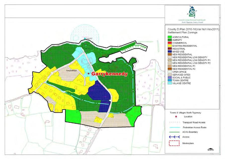
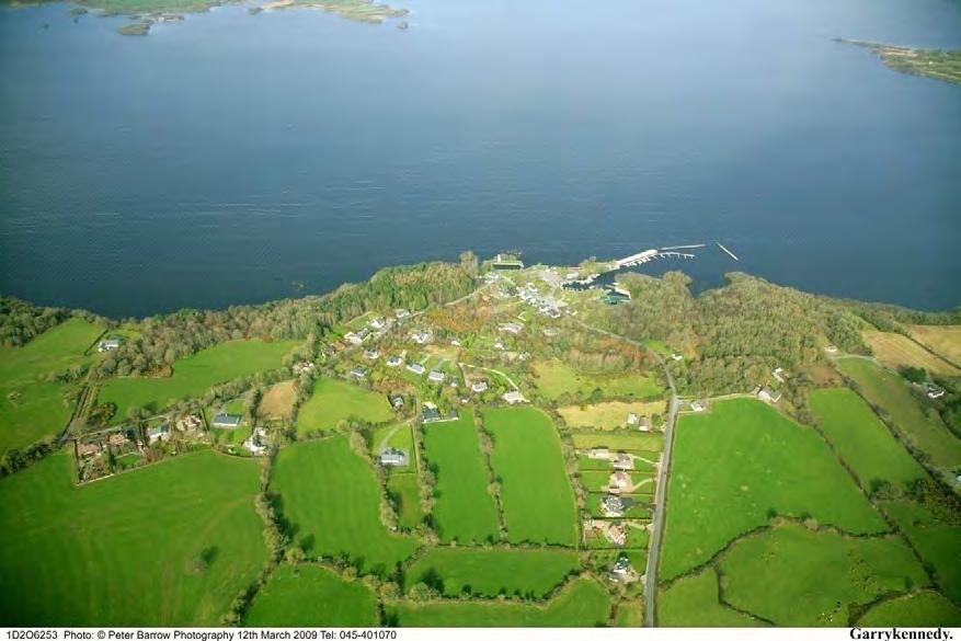
68 GARRYKENNEDY SETTLEMENT PLAN 63
69 1.0 General Introduction and Development Context Location Garrykennedy (Garraí Uí Chinnéide) is located north of Portroe less than two miles off the Nenagh-Ballina R494 lake-drive road. The settlement is located at the edge of Lough Derg. Fronted by two impressive harbours, Castle (in ruins) and a slipway. Garrykennedy is a small rural lakeside village with a distinctive character defined by traditional buildings, stone walls and lake harbours. The land surrounding the village rises and is wooded with many farms. The village is a popular centre for fishing and water sports and attracts a large number of visitors to the area. Over the years, the village has entered and been commended in the Tidy Towns competitions. The Lough Derg Way passes through the village. Population Although the core of the village is quite compact, Garrykennedy extends over a much larger area. It has approximately 50 residential buildings within the village area accounting for a population of about c.100. Of the 50 residences in Garrykennedy, 25 (50%) are holiday homes with no one residing in them on a permanent basis. If the settlement continues to follow this pattern of development, it will result in all the negative aspects associated with rural development in Ireland without any of the benefits of community and cultural development. During the period 1991 and 2006 the population of the Castletown DED (of which Garrykennedy forms part) grew by 24.4%. In fact there has been a higher increase in population in Castletown between the 1996/2002 Census (6.5%) and the 2002/2006 Census (10%). Settlement Form The history of Garrykennedy dates back to the Norman era, when the village was the stronghold of the O Kennedys. The ruins of their castle, built in 1480 on the lake shore remains the centerpiece of the village today. The old stone Quay in the village was built in the late 1700's (extended in 1829) using stone from the old castle. The Quay was used in the 1800 s to ship slate from the nearby slate quarries in Portroe. Generally the original houses form a small terrace, and one and half and two storey dwellings front the road. Newer residential development takes the form of detached houses within cul-de-sacs. A line of one-off detached two storey houses has recently been built on the approach road to the village. Tourism Garrykennedy is a popular tourist destination. Recent improvements to the harbour and the provision of changing facilities cater for increased cruiser traffic and the needs of other visitors. Walking, hiking and fishing are also popular to the area. Key Objectives To facilitate low density, high quality housing appropriate to the village location to ensure adequate critical mass to maintain/improve local service provision. To provide, maintain and enhance social, community and amenity facilities within the village. 64


70 Promotion of Garrykennedy as a tourism destination in North Tipperary and to facilitate and encourage the development of commercial and employment opportunities which are necessary in sustaining its tourism base. To support opportunities for commercial and employment facilities. Cater for a number of small serviced sites developments and also commercial / employment generating development which is appropriate in terms of scale, use and location within the village. Consolidate development within the delineated village boundary in order to protect the area of high amenity within which the village is set. Foster the creation of a more coherent settlement, with adequate critical mass to maintain/improve local service provision. 3.0 Services and Social Infrastructure Water Supply The village is serviced by a public water supply. Waste Water There is no public sewage facility. Roads and Transport Infrastructure. Garrykennedy is situated on local road L , just 2km north of Portore village and conveniently located in relation to Nenagh town. There are currently no public footpaths in the village and public lighting will need upgrading and improvement. Social and Community Infrastructure The village is served by two public houses, one with a restaurant. With regards to amenity facilities there are Bar-B-Q facilities in the village and public toilet and shower facilities. The village is also serviced by private and public marinas. 5.0 Architectural and Archaeological Heritage There are a number of historic buildings and sites within the village boundaries. Significant buildings within the village considered worthy of protection and other buildings/features of note in and around the village are illustrated below. Garrykennedy Castle & Quay Ciss Ryans Public House S 561 S559 and Recorded Monument 65
71 5.0 Natura 2000 Sites Given its location on the shores of Lough Derg, Garrykennedy village abuts Lough Derg proposed Natural Heritage Area (pnha) and Special Area of Conservation (SAC). Any development proposed within the village will need to clearly demonstrate as part of any planning application that no negative impact is caused to the Natura 2000 sites. 6.0 Key Messages for Garrykennedy The settlement should be developed in a properly planned and co-ordinated manner in accordance with the zoning objectives of the settlement plan. Developments which would be harmful to, or that would result in a significant deterioration of habitats and/or disturbance of species in a Natura 2000 site will be resisted. Low density rural clustered style development is promoted on residential zoned sites. Promotion of low-density linear or clustered style development within the village, with the exception of slightly tighter knit development in the core. Facilitate and encourage the development of commercial and employment opportunities which are necessary in sustaining its tourism base. Encourage the use of natural building and boundary materials. The conservation and integration into new development of existing stone walls, trees and native hedgerows, and promotion of similar materials for new boundaries. High quality designs, which are reflective of the existing rural character of the village, without precluding high quality innovative contemporary designs. 7.0 General Development Objectives Proposals for development will be assessed in accordance with the policies and objectives of the County Development Plan, as set out in the main text in Volume 1. In addition to general policy requirements for development, the Council will seek to implement the following objectives: The Council will seek to improve and extend the provision of footpaths and public lighting to enhance the local infrastructure. The Council will seek to foster a village identity and definition of the village by facilitating the provision of hard and soft landscaping and signage. A traditional streetscape which maintains where possible the front boundary wall and trees. The Council will seek to ensure hedgerows, trees and any natural stone walls are preserved and maintained in any new development proposals. Promotion of low-density linear or clustered style development within the village, with the exception of slightly tighter knit development in the core. Buildings which respect the scale, massing and design of existing buildings in the village. The Council will seek to ensure the protection of protected structures, historic buildings and buildings/structures of archaeological significance. The Council will seek to control ribbon development on the approach roads to preserve and consolidate the built environment of the village Protection of public vistas to and from Lough Derg. Protection of Natura 2000 site. 66
72 Encourage and facilitate co-operation between/ amongst the different development interests in order to maximise community gain, for the greater good of the settlement. Encourage the creation of walking routes through the village. All developments within the village shall have due regard to the Garrykennedy Village Design Statement. 8.0 Specific Objective T1: Mixed Use Tourism It is a specific objective of the Council that any proposped development of these sites shall be for tourism related activities which are necessary in sustaining Garrykennedy s tourism base. Development will ensure that the integrity of the Special Protection Area (SPA) and Special Area of Conservation (SAC) are protected. 67
73 STAGE ONE FLOOD RISK ASSESSMENT - GARRYKENNEDY 1.0 Introduction This is the Stage 1 Flood Risk Identification for Variation No. 1 of the County Development Plan 2010 (hereafter referred to as the Plan), prepared in accordance with the Planning System and Flood Risk Management Guidelines for Planning Authorities published by the Department of the Environment, Heritage and Local Government and the OPW in November The purpose of this process is to identify whether there may be any flooding or surface water management issues related to the plan area that may warrant further investigation through stage 2 and 3 Flood Risk Assessment. This stage 1 Flood Risk Assessment forms an integral part of the SEA process for Variation of the Plan and will inform the approach to future planning and development in North Tipperary. 2.0 Flood Risk Identification (Stage 1) The following sources of information have been investigated in order to determine flood risk potential; 1. OPW preliminary Flood Risk Assessment indicative fluvial flood maps. 2. Predictive and historic flood maps, and benefiting land maps, such as those at 3. Predicative flood maps produced under the CFRAM. 4. River Basin Management Plans and reports. 5. Indicative assessment of existing flood risk under preliminary flood risk assessment. 6. Expert advice from OPW 7. Consultation with local authority 8. Topographical maps. 9. GSI Alluvial deposit map. 10. Liable to flood markings on the old 6 inch maps. 11. Newspaper reports. 12. Consultation with Local Community 13. Walkover survey Each of these sources is addressed individually below: 1. OPW preliminary Flood Risk Assessment indicative fluvial flood maps. These are being produced through the catchment-based Flood Risk Assessment and Management Study. These maps are not yet available for the River Shannon Catchment. 2. Predictive and historic flood maps, and benefiting land maps, such as those at This website was consulted. It was found that there were no recorded flood events in the village of Garrykennedy. 3. Predicative flood maps produced under the CFRAM. The Shannon Catchment Flood Risk and Management Study (CFRAM) is to be commenced in 2010 and is scheduled to be completed by the end of Therefore the predicative flood maps to be prepared under this project are not yet available. 68
 is to be commenced in 2010 and is scheduled to be completed by the end of 2013.")
74 4. Catchment Flood Risk Assessment and Management Plans and reports. The Shannon Catchment Flood Risk and Management Study (CFRAM) is to be commenced in 2010 and is scheduled to be completed by the end of Therefore this Stage 1 Flood Risk Assessment has not been able to make reference to any guidance or information which may be contained within it. It is hoped that as part of the review of the Plan, to be completed by 2013 that this information will be available and can feed into the Assessment for the new Plan. 5. Indicative assessment of existing flood risk There is no river flowing through Garrykennedy and the topography is such that the land falls in a south to north direction. It is noted that the OPW has no recorded flood events in and around the village. 6. Expert advice from OPW This Stage 1 Flood Risk has been undertaken with the advantage of expert advice from the OPW. 7. Consultation with local authority A site visit was undertaken and planning histories consulted. There is no evidence of flooding history. 8. Topographical maps. County Topographical maps indicate that Garrykennedy is situated on lands gradually inclining south to north toward the basin of Lough Derg. 9. GSI Alluvial deposit map. GSI Soils Map for Garrykennedy 69
75 The GSI Soils map is set out above for Garrykennedy. The red area represents where Acid Brown Earths Brown Podzolics soils are in existence. The GSI Soils Map has informed the Land Use Zoning Map. 10. Liable to flood markings on the old 6 inch maps. None of the lands within the village or adjacent to the river, within the settlement boundary have been identified on the 6 maps as being liable to flooding. 11. Newspaper reports The Newspaper Reports available at were consulted as part of this Stage 1 Flood Risk Assessment. There was no record of reports of flooding in the village. 12. Consultation with local people. Consideration will be given to any comments received during the public consultation phase on the Development Plan that relate to flooding in the area. 13. Walkover survey to assess potential sources of flooding. A number of inspections were carried out on site by the Planning Officer during the preparation of the Variation. 3.0 Conclusion This is the Stage 1 Flood risk assessment for Variation No. 1 to the County Development Plan The Planning Authority is satisfied that there is no potential flood risk identified in areas planned for growth in Garrykennedy based on an assessment of all the sources listed above and bearing in mind a precautionary approach. This report should be read in conjunction with the SEA and HDA documentation prepared as part of the variation process. It is concluded that there will be no significant flood risk to the Plan area and any surrounding areas as a result of Variation No. 1 to the County Development Plan
76 GORTAGARRY SETTLEMENT PLAN
77 1.0 General Introduction and Development Context Location Gortagarry is a very small settlement located c. 6km south-west of Toomevara. Population The village is located within the DED of Aghnamedle. The population was 275 people in 2006 which represented an increase of 4 people in the since 2002 (CSO, 2006). Settlement Form The settlement is formed by a cluster of buildings, which is afforded a sense of place and identity by the presence of a church and school. 2.0 Key aim and objectives The key aim of the settlement plan is to provide a framework for the development for appropriate residential, commercial and light industrial development and to enhance the visual character and amenities of the village. Key Objectives To facilitate low density, high quality housing appropriate to the village location. To maintain and enhance social, community and amenity facilities within the village. To support opportunities for commercial and employment facilities. 3.0 Services and Social Infrastructure Water Supply The village is serviced by a public water supply. Waste Water The village is not served by the public sewer. Developments within the village are served by individual on-site septic tanks and treatment systems. Roads and Transport Infrastructure The village is served by a network of local roads. There is no footpaths or public lighting with the village. Social and Community Infrastructure The village is served by a church and school which has recently been redeveloped. The village is not served by a shop or other services, however the area benefits from its proximity to services in Toomevara. 4.0 Architectural Heritage Gortagarry Church (S463) is listed as a protected structure under the plan. Gortagarry Church S463 Gortagarry School
78 5.0 Key Messages for Gortagarry The settlement should be developed in a properly planned and co-ordinated manner in accordance with the zoning objectives of the settlement plan. Low density rural clustered style development is promoted on residential zoned sites. Proposals for development will require provision to be made for on-site effluent treatment. This provision will be a key factor which will influence the scale and design of developments. lighting to enhance the local infrastructure. The Council will seek to foster a village identity and definition of the village by facilitating the provision of hard and soft landscaping and signage. The Council will seek to ensure the protection of the protected structures. The Council will seek to control ribbon development on the approach roads to preserve and consolidate the built environment of the village. The Council will seek the provision of play areas in new residential developments. 6.0 General Development Objectives Proposals for development will be assessed in accordance with the policies and objectives of the County Development Plan, as set out in the main text in Volume 1. In addition to general policy requirements for development, the Council will seek to implement the following objectives: The Council will seek to make provision and/or facilitate the provision of footpaths and public
79 HORSE AND JOCKEY SETTLEMENT PLAN

80 1.0 General Introduction and Development Context Location Horse and Jockey is strategically located on the old N8 at its intersection with the new M8 and is at the entry point to the town of Thurles. The Horse and Jockey has been renowned for many years as being at the mid point between Dublin and Cork and as being a place for drivers to stop and get refreshments in the village. The Horse and Jockey public house forms a limited focal point for the village along the main road. The railway station located on the old Clonmel to Thurles railway line has been renovated and is an intrinsic part of the history and character of Horse and Jockey. The remainder of the built fabric of the village is formed by a number of auto service centres and industrial structures. The Horse and Jockey lies c. 7km to the south east of Thurles, close to the border with South Tipperary. Population The village is located within the Rural Electoral Division of Ballymurreen which has experienced a population decline during the inter-censal period from 282 to 252 persons (or a decrease of 10%). The village and its surrounding area has further declined to 231 people in the 2006 Census (a decrease of 8%). Settlement Form While the village is small in nature, it is well known nationally, given its historical position on the national road network. The boundary of the village with its rural hinterland is reasonably well defined, however, there has been liner growth of dwellings on the only local road entering the village. There has been little residential development in the village in the recent past. The village suffers from a lack of any real built fabric. It has until recently been subject to the main Dublin / Cork road running though it and consequently it has not been able to develop a village centre which is evident in other villages in North Tipperary. The village has recently been bypassed and the village has the M8 Motorway Interchange located on the N62, c.500m to the north. This allows numerous opportunities for the village to reclaim itself from being a transient village to a community village. The opening of the M8 motorway has made a significant difference to the quality of life for those living and working in the village, as the large volumes of traffic which used to travel through the village now have an alternative route. Consequently traffic numbers have been vastly reduced. The positive implications of the new roadway far out way the negatives. The positive implications include the following: A vast reduction of traffic going through the village. The reduction of fumes and the improvement in air quality. The reduction of noise levels. Increase in pedestrian and road safety.

81 Negative implications are few and include the following: The possible reduction in business for hotel and other establishments in the area. 2.0 Key aim and objectives The main aim of the settlement plan is to provide a framework for appropriate development while at the same time enhancing the visual character and amenities of the village. The village has an opportunity to benefit from its strategic location just off the M8. It is a key aim of this Plan to facilitate and support opportunities in the Horse and Jockey for the creation of jobs and employment through the provision of commercial, light/semi-light industrial, business park developments etc. around the village. Key Objectives To facilitate low density, high quality housing appropriate to the village location. To maintain and enhance social, community and amenity facilities within the village. To support opportunities for commercial and employment facilities. To focus development around the core of the village. village will need to demonstrate how effluent is to be treated. Roads and Transport Infrastructure Horse and Jockey village is located circa 2.5 km south west of Littleton at a major junction of the old N8, with the N62, and is used as an entry point onto the new M8 motorway via the adjoining interchange. There is a limited network of public footpaths in the area. Public lighting is provided throughout the settlement. Social and Community Infrastructure The village has a hotel, public house, shop, garage, and a sports club. 4.0 Architectural and Archaeological Heritage There are a number of important sites within the village. These include; Former railway station, built c.1880 A detached single-bay two-storey railway signal box, built c.1880, now disused Parkstown House, a detached fivebay two-storey over basement house, built c Services and Social Infrastructure Water Supply The village is serviced by a public water supply. Waste Water The village is not served by the public sewer. Developments within the village are served by individual on-site septic tanks and treatment systems. Any significant developments within the Parkstown Castle (site of) TI , unclassified. They can date from the late 12th to the 16th century AD
82 5.0 Key Messages for the Horse and Jockey The settlement should be developed in a properly planned and co-ordinated manner in accordance with the zoning objectives of the settlement plan. Low density rural clustered style development is promoted on residential zoned sites. The provision of additional passive amenity spaces including playground facilities should be provided. High quality designs, which are particularly reflective of the character of the area, without precluding high quality innovative contemporary designs. The conservation and protection of protected structures, recorded monuments and other features of archaeological and historical merit within the settlement. Avail of opportunities offered to the village by now being bypassed. Maximise the potential of the village for employment generating investment, including commercial, light and semi-light industrial and business park developments etc. given the proximity of the village to the interchange onto the new M General Development Objectives Proposals for development will be assessed in accordance with the policies and objectives of the County Development Plan, as set out in the main text in Volume 1. In addition to general policy requirements for development, the Council will seek to implement the following objectives: The Council will seek to ensure the protection of Protected Structures and archaeological monument (i.e. by preservation in situ or at a minimum protection by record). The Council will seek to clearly define the village boundary on all roads and junctions within the village by means of signage, soft landscaping and traffic calming measures. The Council will seek the improvements to the fabric of the village by means of footpaths and pavement pullouts, defining and reducing the width of the main road within the village and provide tree planting and landscaping along the carriageway to give a sense of enclosure within the village. The Council will seek to regularise on street car parking at the public house and provide a single access point from the kerbside parking onto the main road in order to improve traffic safety in the village. The Council will seek the removal of inappropriate uses and structures from the centre of the village and promote the redevelopment of these sites for residential and other uses suitable to the village context. The Council will seek to ensure that all new housing schemes add to the character of the village through their overall layout and house designs. Housing development should, where applicable, provide an element of streetscape so as to create a village centre and village identity.
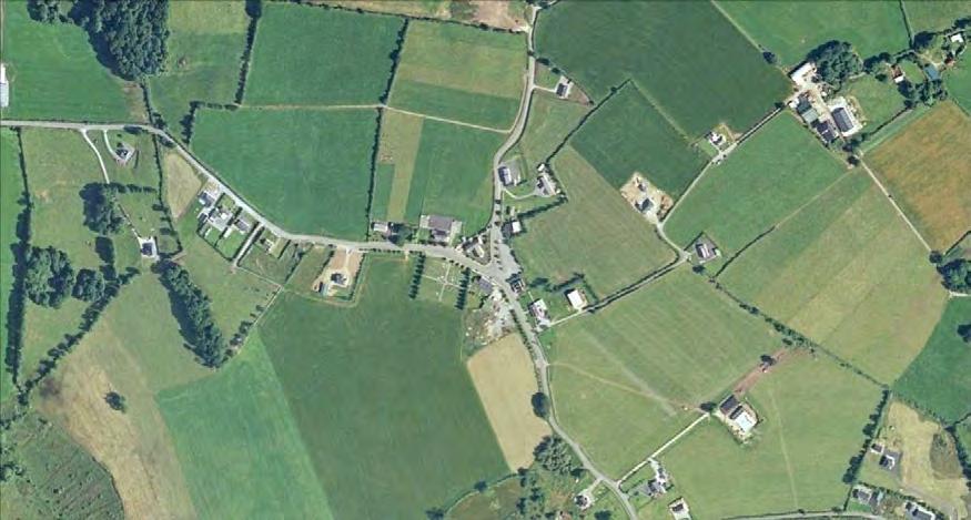
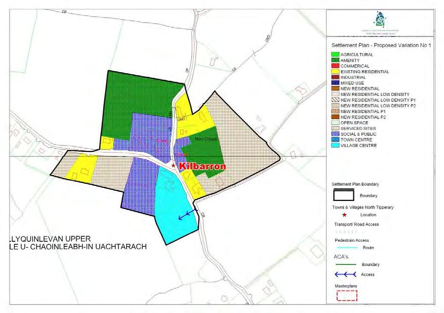
83 KILBARRON SETTLEMENT PLAN 71
84 1.0 General Introduction and Development Context Location Kilbarron is a small village located 2 miles east of Coolbawn. The village is located within the Kilbarron DED. Population Kilbarron Village has witnessed a growth in population between 1996 and 2002 from 553 to 576 people with a slight decrease between 1996 and 2002 to 572 people. Settlement Form The village has developed around the crossroads/junction which is framed by the local church. Development has been ill-defined and no real streetscape exists within the village. However the village has an attractive natural setting with landscaping and natural stone walls contributing to the visual amenity of the settlement. Expansion within the village in recent decades has been very slow. 2.0 Key Aim and Objectives The key aim of the settlement plan is to provide a framework for the development for appropriate residential, commercial and other appropriate development and to enhance the visual character and amenities of the village. Key Objectives To facilitate low density, high quality housing appropriate to the village location to ensure adequate critical mass to maintain/improve local service provision. To provide, maintain and enhance social, community and amenity facilities within the village. To support opportunities for commercial and employment facilities. Cater for a number of small in-depth housing schemes, serviced sites developments and also commercial / employment generating development which is appropriate in terms of scale, use and location within the village. Contain development in order to enhance the village and its setting. 3.0 Services and Social Infrastructure Water Supply The village is serviced by a group water supply. Waste Water The village is not served by the public sewer. Developments within the village are served by individual on-site septic tanks and treatment systems. Roads and Transport Infrastructure. The village is served by a local road network which link the settlement to Borrisokane and the N52 and N65. 72


85 There is a limited network of public footpaths and public lighting within the village. The village is clearly marked with signage on all approach roads. Social and Community Infrastructure The village is serviced by a shop, post office and public house, a National School which has a recent extension, an impressive Roman Catholic Church and graveyard and a community centre. In recent times a number of planning permissions have been granted for one off housing development on housing on all approaches to the village. 4.0Architectural and Archaeological Heritage There are a small number of historic buildings and sites within the village boundaries. Significant buildings within the village which have been included on the Record of Protected Structures include the Church and the school Kilbarron R.C. Church S 67 Kilbarron National School S 68 A ballaun stone is located in the grounds of the R.C. church in the village. The stone is a small granite boulder with a deep circular depression and was found in a field beside an old building that was believed by locals to have been a possible church. 5.0 Key Messages for Kilbarron The settlement should be developed in a properly planned and co-ordinated manner in accordance with the zoning objectives of the settlement plan. Low density rural clustered style development is promoted on residential zoned sites. Promotion of low-density linear or clustered style development within the village, with the exception of slightly tighter knit development in the core. The conservation and integration into new development of existing stone walls, trees and native hedgerows, and promotion of similar materials for new boundaries. High quality designs, which are reflective of the existing rural character of the village, without precluding high quality innovative contemporary designs. Proposals for development will require provision to be made for on-site effluent treatment. This provision will be a key factor which will influence the scale and design of all developments. 73
86 6.0 General Development Objectives Proposals for development will be assessed in accordance with the policies and objectives of the County Development Plan, as set out in the main text in Volume 1. In addition to general policy requirements for development, the Council will seek to implement the following objectives: The Council will seek to make provision and/or facilitate the provision of footpaths and public lighting to enhance the local infrastructure. The Council will seek to foster a village identity and definition of the village by facilitating the provision of hard and soft landscaping and signage. The creation of streetscapes within the village centre will be particularly encouraged. The Council will seek to ensure the protection of the protected structure and archaeological monument (i.e. by preservation in situ or at a minimum protection by record). The Council will seek to control ribbon development on the approach roads to preserve and consolidate the built environment of the village. The Council will seek to ensure hedgerows, trees and any natural stone walls are preserved and maintained in any new development proposals. 74
87 STAGE ONE FLOOD RISK ASSESSMENT - KILBARRON 1.0 Introduction This is the Stage 1 Flood Risk Identification for Variation No. 1 of the County Development Plan 2010 (hereafter referred to as the Plan), prepared in accordance with the Planning System and Flood Risk Management Guidelines for Planning Authorities published by the Department of the Environment, Heritage and Local Government and the OPW in November The purpose of this process is to identify whether there may be any flooding or surface water management issues related to the plan area that may warrant further investigation through stage 2 and 3 Flood Risk Assessment. This stage 1 Flood Risk Assessment forms an integral part of the SEA process for Variation of the Plan and will inform the approach to future planning and development in North Tipperary. 2.0 Flood Risk Identification (Stage 1) The following sources of information have been investigated in order to determine flood risk potential; 1. OPW preliminary Flood Risk Assessment indicative fluvial flood maps. 2. Predictive and historic flood maps, and benefiting land maps, such as those at 3. Predicative flood maps produced under the CFRAM. 4. River Basin Management Plans and reports. 5. Indicative assessment of existing flood risk under preliminary flood risk assessment. 6. Expert advice from OPW 7. Consultation with local authority 8. Topographical maps. 9. GSI Alluvial deposit map. 10. Liable to flood markings on the old 6 inch maps. 11. Newspaper reports. 12. Consultation with Local Community 13. Walkover survey Each of these sources is addressed individually below: 1. OPW preliminary Flood Risk Assessment indicative fluvial flood maps. These are being produced through the catchment-based Flood Risk Assessment and Management Study. These maps are not yet available for the River Shannon Catchment. 2. Predictive and historic flood maps, and benefiting land maps, such as those at This website was consulted. It was found that there were no recorded flood events in the village of Kilbarron. There is however a turlough with a recorded flood event. It is 0.16km to the south east of the village (Newchapel Turlough in the townland of Firgrove). 3. Predicative flood maps produced under the CFRAM. The Shannon Catchment Flood Risk and Management Study (CFRAM) is to be commenced in 2010 and is scheduled to be completed by the end of Therefore the predicative flood maps to be prepared under this project are not yet available. 75
 is to be commenced in 2010 and is scheduled to be completed by the end of 2013.")
88 4. Catchment Flood Risk Assessment and Management Plans and reports. The Shannon Catchment Flood Risk and Management Study (CFRAM) is to be commenced in 2010 and is scheduled to be completed by the end of Therefore this Stage 1 Flood Risk Assessment has not been able to make reference to any guidance or information which may be contained within it. It is hoped that as part of the review of the Plan, to be completed by 2013 that this information will be available and can feed into the Assessment for the new Plan. 5. Indicative assessment of existing flood risk There is no river flowing through Kilbarron village. The topography of the land is fairly level overall. No flood event was recorded in the village of Kilbarron. 6. Expert advice from OPW This Stage 1 Flood Risk has been undertaken with the advantage of expert advice from the OPW. 7. Consultation with local authority A site visit was undertaken and planning histories consulted. There is no evidence of flooding history. 8. Topographical maps. County Topographical maps do not adequately address the local Kilbarron area, as they are based on the topography of the county. 9. GSI Alluvial deposit map. GSI Soils Map for Kilbarron 76
89 The GSI Soils map is set out above for Kilbarron The purple area represents that an area where soil in existence is grey brown podzolics, brown earths (medium-high base status). The type group is deep well drained minerals. No alluvial deposits were identified in the Kilbarron village area. The GSI Soils Map has informed the Land Use Zoning Map. 10. Liable to flood markings on the old 6 inch maps. None of the lands within the village or within the settlement boundary have been identified on the 6 maps as being liable to flooding. The area around Newchapel Turlough is liable to flood. 11. Newspaper reports The Newspaper Reports available at were consulted as part of this Stage 1 Flood Risk Assessment. There was no record of reports of flooding in the village. 12. Consultation with local people. Consideration will be given to any comments received during the public consultation phase on the 2010 Development Plan variation that relate to flooding in the area. 13. Walkover survey to assess potential sources of flooding. A number of inspections were carried out on site by the Planning Officer during the preparation of the Variation. 3.0 Conclusion This is the Stage 1 Flood risk assessment for Variation No. 1 to the County Development Plan The Planning Authority is satisfied that there is no potential flood risk identified in areas planned for growth in Kilbarron based on an assessment of all the sources listed above and bearing in mind a precautionary approach. This report should be read in conjunction with the SEA and HDA documentation prepared as part of the variation process. It is concluded that there will be no significant flood risk to the Plan area and any surrounding areas as a result of Variation No. 1 to the County Development Plan
90 KILCOMMON SETTLEMENT PLAN
91 Kilcommon Lower 1.0 General Introduction and Development Context Location Kilcommon village is located on the southern foothills of the Silvermines Mountains mid-way between Thurles and Newport. Kilcommon is unique, as it forms two distinct parts, namely Kilcommon Upper which is located c. 1.25km north of the regional road R-503 and Kilcommon Lower which is located at the junction with the regional road R-503. Population The settlement is located within the DED of Foilnaman. The population in the DED was 290 in 2006, which represented a decrease of 3 persons since 2002 (CSO, 2006) Settlement Form Killcommon Upper is a well defined traditional rural village, bounded by the Bilboa River to the north, and characterised by a strong streetscape of vernacular buildings, a church and associated gardens which contributes significantly to the visual amenity and character of the area. The village has been subject to little new development, which from a built environment perspective has served to

92 maintain its traditional and picturesque context. Killcommon Lower is defined by a cluster of development consisting of a pub/shop, private housing and playing pitch. 2.0 Key aim and objectives The key aim of the settlement plan is to provide a framework for the development for appropriate residential, commercial and light industrial development and to preserve and enhance the visual character and amenities of the village. Key Objectives To encourage the re-use of existing buildings to strengthen the physical and social fabric of the village. To preserve the village setting of Kilcommon Upper by promoting high quality vernacular designs appropriate to the village setting. To maintain and enhance social, community and amenity facilities within the village. To support opportunities for commercial and employment facilities. 3.0 Services and Social Infrastructure Water Supply The settlement is serviced by a public water supply. Waste Water The settlement is not serviced by a public wastewater treatment plant. Developments within the village are served by individual on-site septic tanks and treatment systems. Roads and Transport Infrastructure The village while having a relatively remote rural setting is well connected to Thurles via the R503 and Nenagh via the R-497. The upper village has a network of public lighting and footpaths, however this infrastructure does not serve the entire area. The lower village is not served by public lighting and footpaths. Services and Social Infrastructure The upper village provides a range of services including two pubs, school, church, graveyard and community hall. The village also benefits from a beautifully maintained prayer garden and a picnic area near the Bilboa river. 4.0 Architectural and Archaeological Heritage The Catholic Church at the centre of Kilcommon Upper, is listed as a protected structure under Volume III Plan. The church was built c. 1875, is a cruciform plan church with an associated graveyard and prayer garden which adds to its setting.
 also cover the Bilboa River. 5.0 Key Messages for Kilcommon The parochial house built around c. 1800 is also listed for protection under the Plan.")
.")
93 RC Church S802 whereby the upper village and part of the lower village is designated a SPA the E.U. Bird Directive of special conservation interest to the Hen Harrier. The Lower River Shannon (SAC Site No ) also cover the Bilboa River. 5.0 Key Messages for Kilcommon The parochial house built around c is also listed for protection under the Plan. The structure is located to the west of the church also takes a prominent setting within the village. Parochial House S803 Archaeological Monuments A former Benedictine Priory lies just north of the existing church and is a and is a recorded monument (TN02590). Full record of protected structures is contained in Volume III of the Draft Plan and recorded monuments are illustrated on the attached map. Conservation Designations Kilcommon is located is an area of significant natural heritage significance, The settlement should be developed in a properly planned and co-ordinated manner in accordance with the zoning objectives of the settlement plan. Low density rural clustered style development is promoted on residential zoned sites. The re-development of buildings within the village for appropriate commercial and residential uses is encouraged. The amenity areas including the prayer garden and picnic area should be preserved and enhanced by the linking the spaces by means of a walkway by the river. Proposals for development will require provision to be made for on-site effluent treatment. This provision will be a key factor, which will influence the scale and design of developments. 6.0 General Development Objectives Proposals for development will be assessed in accordance with the policies and objectives of the County Development Plan, as set out in the main text in Volume 1. In addition to general policy requirements for development, the
94 Council will seek to implement the following objectives: The Council will seek to make provision and/or facilitate the provision of footpaths and public lighting to enhance the local infrastructure. The Council will seek to foster a village identity and enhance the definition of the village by facilitating the provision of hard and soft landscaping and signage. The Council will seek to encourage the re-use of buildings along the streetscape. The Council will seek to ensure the protection of the protected structures and archaeological monument (i.e by preservation in situ or at a minimum protection by record). The Council will seek to control ribbon development on the approach roads to preserve and consolidate the built environment of the village. The Council will seek to ensure hedgerows, trees and any natural stone walls are preserved and maintained in any new development proposals.
95 KILEEN SETTLEMENT PLAN
96 1.0 General Introduction and Development Context Location Kileen is a small dispersed settlement, located 5km to the west of Dolla and 5km to the east o Templederry at the junction of two local roads, the L-2123 and L Population The settlement is located within the DED of Dolla. The population in this DED has remained effectively static in recent years, only growing from 215 people to 217 people during the inter-censal period (CSO). Settlement Form The built settlement is formed by a cluster of buildings, dispersed along both Local Roads. The main focal buildings would include the school, the Church and the old shop at the junction of the local roads. The settlement has a scenic natural setting given its location between Ballinacurra Hill and Cooneen Hill. The natural setting is enhanced by the mature hedgerows and trees which line the approach roads, and the significant fall in gradient between the local road junction and the school. 2.0 Key aim and objectives The key aim of the settlement plan is to provide a framework for the development for appropriate residential, commercial and light industrial development and to enhance the visual character and amenities of the village. Key Objectives To facilitate low density, high quality housing appropriate to the village location. To maintain and enhance social, community and amenity facilities within the village. To support opportunities for commercial and employment facilities. 3.0 Services and Social Infrastructure Water Supply The village is serviced by a group water scheme which has a number of supplies in an around the village. Waste Water The village is not serviced by public waste waster treatment system. Developments within the village are served by individual on-site septic tanks and treatment systems. Given the presence of water sources within and around the village, any treatment of effluent will have to have regard to public health and a source protection area around the wells. Roads and Transport Infrastructure The settlement is located on two local transport routes which would service primarily local traffic. The main route between Dolla and Templederry is located to the south of the village. There are no public footpaths within the village and there is a limited network of public lighting. Social and Community Infrastructure The settlement is served by a school, a church and a shop which appears to be closed. 4.0 Architectural Heritage Kileen Roman Catholic Church is a protected structure (S20) under the County Development Plan.
97 as set out in the main text in Volume 1. In addition to general policy requirements for development, the Council will seek to implement the following objectives: 5.0 Key Messages for Kileen The settlement should be developed in a properly planned and coordinated manner in accordance with the zoning objectives of the settlement plan. Low density rural clustered style development is promoted on residential zoned sites. Proposals for development will require provision to be made for onsite effluent treatment. This provision will be a key factor which will influence the scale and design of developments. Regard should be had to the presence of wells serving the Group Water Scheme in and around the village. The Council will seek to make provision and/or facilitate the provision of footpaths and public lighting to enhance the local infrastructure. The Council will seek to foster a village identity and definition of the village by facilitating the provision of hard and soft landscaping and signage. The Council will seek to ensure the protection of the protected structure and archaeological monument (i.e by preservation in situ or at a minimum protection by record). The Council will seek to control ribbon development on the approach roads to preserve and consolidate the built environment of the village. The Council will seek to ensure hedgerows, trees and any natural stone walls are preserved and maintained in any new development proposals. 6.0 General Development Objectives Proposals for development will be assessed in accordance with the policies and objectives of the County Development Plan,
98 KILLOSCULLY SETTLEMENT PLAN
99 1.0 General Introduction and Development Context Location Killoscully is a small rural settlement located approximately 8km to the north east of Newport, at the foothill of Keeper Hill. Population The settlement is located within the DED s of Killoscully. The area experienced a significant population growth during the intercensal period from 311 to 387 people or an increase of 24% (CSO, 2006) Settlement Form The village is a very small traditional settlement formed by a cluster of a traditional vernacular buildings centred around the local thatched pub. The settlement has preserved its rural character with very limited encroachment of modern developments. In this regard, the northern and southern approach roads, are lined by natural trees and hedgerows which from a visually pleasing vista and contribute to the visual amenity and setting of the village. 2.0 Key aim and objectives The key aim of the settlement plan is to provide a framework for the development for appropriate residential, commercial and light industrial development and to enhance the visual character and amenities of the village. Key Objectives To facilitate low density, high quality housing appropriate to the village location. To maintain and enhance social, community and amenity facilities within the village. To preserve and enhance the rural character of the village by promoting rural vernacular design and retention of natural boundaries and stone walls. To support opportunities for commercial and employment facilities. 3.0 Services and Social Infrastructure Water Supply The village is serviced by a public water supply. Waste Water A public wastewater treatment plant does not service the village. Developments within the village are served by individual on-site septic tanks and treatment systems. Roads and Transport Infrastructure The village is served by a relatively poor local network of roads.
 This monument is located to the north of the")

100 There is no network of public footpaths and there is a limited public lighting. Social and Community Infrastrcture The village is served by a public house, a church, graveyard and community hall Church and Graveyard (TN ) This monument is located to the north of the existing church and dates from c. 500 A.D. onwards. Cromwells Road (TN ) 4.0 Architectural and Archaeological Heritage Kiloscully RC Church and the thatch pub are listed protected structures under the Plan. Kiloscully Church S731 Cromwells Road runs to the north-east of the village. The road is a way, deliberately constructed between places, used by travellers and wide enough to accommodate vehicles. 5.0 Key Messages for Killoscully Thatched Pub S-714 The village and its surrounding area also has a rich archaeological heritage and the following features are particularly noteworthy: The settlement should be developed in a properly planned and co-ordinated manner in accordance with the zoning objectives of the settlement plan. Low density rural clustered style development is promoted on residential zoned sites. Rural vernacular architecture in keeping with the village character is encouraged. Proposals for development will require provision to be made for on-site effluent treatment. This provision will be a key factor, which will influence the scale and design of developments. 6.0 General Development Objectives
101 Proposals for development will be assessed in accordance with the policies and objectives of the County Development Plan, as set out in the main text in Volume 1. In addition to general policy requirements for development, the Council will seek to implement the following objectives: The Council will seek to make provision and/or facilitate the provision of footpaths and public lighting to enhance the local infrastructure. The Council will seek to foster a village identity and definition of the village by facilitating the provision of hard and soft landscaping and signage. The Council will seek to ensure the protection of the protected structures and archaeological monuments (i.e by preservation in situ or at a minimum protection by record). The Council will seek to control ribbon development on the approach roads to preserve and consolidate the built environment of the village. The Council will seek to ensure hedgerows, trees and natural stone walls are preserved and maintained in any new development proposals. The Council will seek to facilitate an extension to the existing graveyard.
102 KNOCK SETTLEMENT PLAN
103 1.0 General Introduction and Development Context Location Knock is a village located c. 8km south east of Roscrea Town and just east of the Co. Laois border. Population The village is located within the DED of Bourney West. The population was 371 people in 2006, which represented a decrease of 12 people since 2002 (CSO, 2006). Settlement Form Knock is a small crossroads village, interestingly located at the meeting point of five local roads. The village is defined by the community buildings including the church, former school and pub. 2.0 Key aim and objectives The key aim of the settlement plan is provide a framework for the development for appropriate residential, commercial and light industrial development and to enhance the visual character and amenities of the village. Key Objectives To facilitate low density, high quality housing appropriate to the village location. To maintain and enhance social, community and amenity facilities within the village. To support opportunities for commercial and employment facilities. 3.0 Services and Social Infrastructure Water Supply The village is serviced by a public water supply. Waste Water The village is not served by the public sewer. Developments within the village are served by individual on-site septic tanks and treatment systems. Roads and Transport Infrastructure The village is well served by transport links, located just south of the N7 and east of the new M7. There are no public footpaths within the village and there is a limited network of public lighting. Social and Community Infrastructure The village is served by a church and a pub. There is no shop in the village and the school closed a number of years ago. 4.0 Architectural Heritage The RC Church is a protected structure under the Plan. RC Church S609
104 5.0 Key Messages for Knock The settlement should be developed in a properly planned and co-ordinated manner in accordance with the zoning objectives of the settlement plan. The service provision should be expanded to contribute to the viability of the settlement. Low density rural clustered style development is promoted on residential zoned sites. The re-opening of the local school is encouraged. Proposals for development will require provision to be made for on-site effluent treatment. This provision will be a key factor, which will influence the scale and design of developments. The Council will seek to ensure the protection of the protected structure. The Council will seek to control ribbon development on the approach roads to preserve and consolidate the built environment of the village. The Council will seek to ensure hedgerows, trees and any natural stone walls are preserved and maintained in any new development proposals. 6.0 General Development Objectives Proposals for development will be assessed in accordance with the policies and objectives of the County Development Plan, as set out in the main text in Volume 1. In addition to general policy requirements for development, the Council will seek to implement the following objectives: The Council will seek to make provision and/or facilitate the provision of footpaths and public lighting to enhance the local infrastructure. The Council will seek to foster a village identity and definition of the village by facilitating the provision of hard and soft landscaping and signage.
105 LELAGH SETTLEMENT PLAN
106 1.0 General Introduction and Development Context Location Lelagh is a small dispersed settlement, located 65km to the west of Riverstown and 3.5km to the south of Rathcabbin at the four way junction of two Regional roads, the R- 439 and R438. Population The settlement is located within the DED of Graigue. The population in this DED has grown in recent years, growing from 267 people to 276 people during the inter-censal period (CSO). Settlement Form The built settlement is formed by a cluster of buildings, dispersed along both Regional Roads. The main focal buildings would include the old petrol station which is closed down. There is little in the way of significant trees or hedgrows in or around the settlement. The gradient is relatively flat and the dispersed nature of the buildings provides for no definition to the settlement. 2.0 Key aim and objectives The key aim of the settlement plan is to provide a framework for the development for appropriate residential, commercial and light industrial development and to enhance the visual character and amenities of the village. Key Objectives To facilitate low density, high quality housing appropriate to the village location. To maintain and enhance social, community and amenity facilities within the village. To support opportunities for commercial and employment facilities. 3.0 Services and Social Infrastructure Water Supply The settlement is serviced by a public water pipe which runs along the R439. Waste Water The village is not serviced by public waste waster treatment system. Developments within the village are served by individual on-site septic tanks and treatment systems. Roads and Transport Infrastructure The settlement is strategically located on two main regional transport routes, the R438 running north-south from Nenagh / Borrisokane towards Cloghan and onto the N62 and east-west from Birr/Riverstown and Portumna. There are no public footpaths within the village and there is no public lighting. Social and Community Infrastructure The settlement is used to be served by a shop and petrol station, which has now closed. There are no other social or community infrastructure in the settlement. 4.0 Architectural Heritage Walshpark Lodge is a protected structure (S397) under the County Development Plan. 5.0 Key Messages for Lelagh
107 The settlement should be developed in a properly planned and coordinated manner in accordance with the zoning objectives of the settlement plan. Low density rural clustered style development is promoted on residential zoned sites. Proposals for development will require provision to be made for onsite effluent treatment. This provision will be a key factor which will influence the scale and design of developments. maintained in any new development proposals, where appropriate. 7.0 General Development Objectives Proposals for development will be assessed in accordance with the policies and objectives of the County Development Plan, as set out in the main text in Volume 1. In addition to general policy requirements for development, the Council will seek to implement the following objectives: The Council will seek to make provision and/or facilitate the provision of footpaths and public lighting to enhance the local infrastructure. The Council will seek to foster a village identity and definition of the village by facilitating the provision of hard and soft landscaping and signage. A defined settlement boundary and possible traffic calming may need to be examined. The Council will seek to ensure the protection of the protected structure. The Council will seek to control ribbon development on the approach roads to preserve and consolidate the built environment of the village. The Council will seek to ensure hedgerows, trees and any natural stone walls are preserved and
108 LOUGHMORE SETTLEMENT PLAN
109 1.0 General Introduction and Development Context Location Loughmore village is located approximately c. 0.5km east of the N62, Thurles-Templemore national secondary road. Thurles is located 4km to the south and Templemore is located c. 9km to the north. Population The village is located in the DED of Loughmore. The population of the DED in 2006 was 599, an increase of 30 people since 2002 (CSO, 2006). Settlement Form The village has developed in a linear pattern along the local road with the railway line and River Suir forming the eastern boundary. The settlement is characterised by its historic links to the past with Loughmore Court located in the southern foreground and the old mill at the eastern boundary. The structures contribute to Loughmore s distinct character and amenity of the settlement. 2.0 Key Aim and Objectives The key aim of the settlement plan is to provide a framework for the development for appropriate residential, commercial and light industrial development and to enhance the visual character and amenities of the village. contribute to the distinct character of the settlement. 3.0 Services and Social Infrastructure Water Supply The village is serviced by an existing public water supply. Waste Water Loughmore was one of the Seven Villages Sewage DBO Sewerage Scheme. The waste water treatment plant became operational in November, 2008 and caters for a design population equivalent of 300 people. Roads and Transport Infrastructure The settlement is well serviced through its proximity of the N62 to Thurles and Templemore. There is a limited network of public footpaths. Public lighting is provided but does not cover the entire area. Social and Community Infrastructure The village is served by a church, school, public house, shop and amenity area. Key Objectives To promote the development of infill sites to consolidate the streetscape and to promote low density cluster housing development to provide a range of house types. To maintain and enhance social, community within the village. To support opportunities for commercial and employment facilities. To protect and enhance the architectural and archaeological heritage which 4.0 Archaeological and Archaeological Heritage The village has a rich architectural and archaeological heritage and has a number of features of interest. Of particular prominence in the settlement is the Mill at the eastern boundary, built c and which is protected


110 under the Plan and any works to the parts of the Mill utilised by bats should only be carried out under license. Loughmore Court located to the southeast, which is a recorded monument. Mill S762 Maintain the natural heritage of the village. Woodland within the Settlement Plan area will be maintained or restored (if necessary to fell trees for safety reasons) as a foraging resource for bats. 6.0 General Development Objectives Proposals for development will be assessed in accordance with the policies and objectives of the County Development Plan, as set out in the main text in Volume 1. In addition to general policy requirements for development, the Council will seek to implement the following objectives: Loughmore Court Full record of protected structures is contained in Volume III of the Plan. 5.0 Key Messages for Loughmore The settlement should be developed in a properly planned and co-ordinated manner in accordance with the zoning objectives of the settlement plan. The up-graded wastewater treatment plant provides an opportunity to facilitate new residential and commercial developments. Low density rural clustered style development is promoted on residential zoned sites. The River Suir provides an opportunity to provide an additional amenity area with an associated link by way of a pedestrian bridge to the Loughmore Court. The Council will seek to make provision and/or facilitate the provision of footpaths and public lighting to enhance the local infrastructure. The Council will seek to foster a village identity and definition of the village by facilitating the provision of hard and soft landscaping and signage. The Council will seek to control ribbon development on the approach roads to preserve and consolidate the built environment of the village. The Council will seek to facilitate the provision of amenity and play areas on the designated amenity space and within new proposals for development. The Council will seek to ensure that new development contributes to this provision. The Council will seek to ensure hedgerows, trees and any natural stone walls are preserved and maintained in any new development proposals
111 MOYCARKEY SETTLEMENT PLAN
112 1.0 General Introduction and Development Context Location Moycarkey is a small village located c. 6km south of Thurles and west of the N62. Population Moycarkey is located within the DED of Moycarkey which recorded a population of 533 in The population had increased by 13 people (2.5%) during the inter-censal period (CSO, 2006). Settlement Form The village is formed by a cluster of buildings, with the ruins of the old settlement, church and graveyard forming a focal centre point of the village. The village has witnessed limited new residential development. However there has been a significant build up of one-off housing along the approach roads due to Moycarkey s proximity to Thurles. 2.0 Aim and Objectives The key aim of the settlement plan is provide a framework for the development for appropriate residential, commercial and light industrial development and to enhance the visual character and amenities of the village. Key Objectives To facilitate low density, high quality housing appropriate to the village location. To preserve the village setting and archaeological heritage of the area. To support opportunities for commercial and employment facilities. 3.0 Services and Social Infrastructure Water Supply The village is serviced by a public water supply. Waste Water The village is not served by the public sewer. Developments within the village are served by individual on-site septic tanks and treatment systems. Roads and Transport Infrastructure The settlement is served by a local road network, but is strategically located close to key transport links, north through Thurles and south to the M8 Cork to Dublin Motorway. There is a very limited network of public footpaths within the village and there is a limited network of public lighting. Social and Community Infrastructure The settlement is poorly served by community infrastructure and does not have a retail function. However, the village has a local church and a local school, which is located 1.5km to the north in Drumgowern. Notwithstanding the lack of services in the immediate vicinity, residents of Morcarkey have the benefit of services

113 in nearby Thurles and the Horse and Jockey. 4.0 Architectural and Archaeological Heritage Morcarkey despite its small scale is rich in Architectural and Archaeological heritage. A number of structures are protected under the Plan and include Morcarkey Cottage, which is a detached five bay single-storey house with domered attic and built c The house as noted by the NIAH makes a positive contribution to the streetscape adjoining the graveyard and St. Peter s Church. Moycarkey Cottage S865 The village has a number of recorded monuments as illustrated on the attached map and as a result the land within the settlement boundary exhibits significantly archaeological potential. The recorded monuments include the ruined church and graveyard at the heart of the village. Full record of protected structures is contained in Volume III of the Plan. 5.0 Key Messages for Moycarkey The settlement should be developed in a properly planned and co-ordinated manner in accordance with the zoning objectives of the settlement plan. Low density rural clustered style development is promoted on residential zoned sites. Developments should take reference from historical buildings and vernacular architecture of the village. The architectural heritage of the village should be preserved and enhanced as key amenity facilities for the village. Proposals for development will require provision to be made for on-site effluent treatment. This provision will be a key factor which will influence the scale and design of developments. 6.0 General Development Objectives Proposals for development will be assessed in accordance with the policies and objectives of the County Development Plan, as set out in the main text in Volume 1. In addition to general policy requirements for development, the Council will seek to implement the following objectives:
114 The Council will seek to make provision and/or facilitate the provision of footpaths and public lighting to enhance the local infrastructure. The Council will seek to foster a village identity and definition of the village by facilitating the provision of hard and soft landscaping and signage. The Council will seek to ensure the protection of the protected structures and archaeological monument (i.e by preservation in situ or at a minimum protection by record). The Council will seek to control ribbon development on the approach roads to preserve and consolidate the built environment of the village. The Council will seek to ensure hedgerows, trees and any natural stone walls are preserved and maintained in any new development proposals.
115 MOYNE SETTLEMENT PLAN
116 1.0 General Introduction and Development Context Location Moyne is located c. 8km northeast of Thurles. however there is significant ribbon development on both approach roads to the north and south. 2.0 Key aim and objectives The key aim of the settlement plan is provide a framework for the development for appropriate residential, commercial and light industrial development and to enhance the visual character and amenities of the village. Population Moyne is located within the DED of Moyne. The population of the district electoral division was 494 in 2006, which represented an increase of 10 people or 2.1% since 2002 (CSO, 2006). Settlement Form The village has a traditional form and character, with a strong vernacular streetscape and church located in the centre point of the village. Key Objectives To facilitate low density, high quality housing appropriate to the village location. To encourage the re-use and appropriate re-development of buildings along the main street to protect and enhance the viability of the settlement. To maintain and enhance social, community and amenity facilities within the village. To support opportunities for commercial and employment facilities. 3.0 Services and Social Infrastructure Water Supply The village is serviced by a public water supply. The village has experienced little new development within its boundary, Waste Water The village is not served by the public sewer. Developments within the village are served by individual on-site septic tanks and treatment systems.


117 Roads and Transport Infrastructure The village is served by a local road network which links the settlement to Thurles to the southwest and to the Cork-Dublin Motorway c. 7km to the south. There is a limited network of public footpaths and lighting within the settlement boundary. Social and Community Infrastructure The village is served by a church, school, public house, garda station and community hall. The village is not currently served by a local shop. 4.0 Architectural and Archaeological Heritage Moyne has a number of buildings of architectural significance and both Molony s and Mullany s pubs and the church are protected structures under the Plan. Molony s Pub S777 Mullany s Pub S777 St. Mary s RC Church S775 The old Church and graveyard located to the rear of the community hall is a recorded monument (TN ). Full record of protected structures are contained in Volume III of the Plan.
118 5.0 Key Messages for Moyne The settlement should be developed in a properly planned and co-ordinated manner in accordance with the zoning objectives of the settlement plan. Low density rural clustered style development is promoted on residential zoned sites. The appropriate re-development and re-use of existing premises on the main street, to include the re-establishment of a local shop is encouraged. Proposals for development will require provision to be made for on-site effluent treatment. This provision will be a key factor, which will influence the scale and design of developments. The Council will seek to ensure the protection of the protected structures and archaeological monuments (i.e by preservation in situ or at a minimum protection by record). The Council will seek to control ribbon development on the approach roads to preserve and consolidate the built environment of the village. The Council will seek to ensure hedgerows, trees and any natural stone walls are preserved and maintained in any new development proposals. The Council will seek the provision of new play areas in new residential developments to contribute to the amenity provision of the village. 6.0 General Development Objectives Proposals for development will be assessed in accordance with the policies and objectives of the County Development Plan, as set out in the main text in Volume 1. In addition to general policy requirements for development, the Council will seek to implement the following objectives: The Council will seek to make provision and/or facilitate the provision of footpaths and public lighting to enhance the local infrastructure. The Council will seek to foster a village identity and definition of the village by facilitating the provision of hard and soft landscaping and signage.
119 RIVERSTOWN SETTLEMENT PLAN
120 1.0 General Introduction and Development Context Location The village of Riverstown is strategically located at the junction of the N52 and the R489. It lies at the border between North Tipperary and County Offaly, with the Little Brosna River dividing it from the neighbouring village of Drumbane in Co. Offaly. The village lies only 4km from Birr. Population Riverstown is located in the D.E.D. of Riverstown with a population of 522. The population has increased by 40 people (8.3%) between (CSO, 2006). Settlement Form The village is dispersed and linear in nature extending over a kilometre along the R489. Limited development has taken place along the N52. While some residential development has taken place in recent years, the village appears to have developed through the provision of one-off housing. The core of the village is located around the river and provides an attractive centre when viewed with the village of Drumbane on the Offaly side. 2.0 Key aim and objectives The key aim of the settlement plan is to provide a framework for the development for appropriate residential commercial and light industrial development and to enhance the visual character and amenities of the village. Key Objectives To facilitate low density, high quality housing appropriate to the village location. To maintain and enhance social, community and amenity facilities within the village. To support opportunities for commercial and employment facilities. To focus development around the core of the village. 3.0 Services and Social Infrastructure Water Supply The village is serviced by a public water supply. Waste Water The village is serviced by a sewage treatment plant. However, up-grade works may be required to cater for additional development.


121 Roads and Transport Infrastructure The village is located at the junction of national secondary road N52 (Borrisokane/Birr Road) and regional road R489 to Portumna. Riverstown Bridge a five-arched limestone road bridge over Little Brosna River, built c There is a limited network of public footpaths in the area. Public lighting is provided throughout the settlement. Social and Community Infrastructure The village centre provides a selection of services such as shops, public houses, a school, a community hall, a playing field and a church. 4.0 Architectural and Archaeological Heritage There are a number of important sites within the village. These include; Castleview, a detached three-bay two-storey over half basement house, built c Castle - Motte And Bailey Terraced of houses in the village 5.0 Key Messages for Riverstown The settlement should be developed in a properly planned and co-ordinated manner in accordance with the zoning objectives of the settlement plan. Low density rural clustered style development is promoted on residential zoned sites. The provision of additional passive amenity spaces including playground facilities should be provided. High quality designs, which are particularly reflective of the predominantly rural character of the area, without precluding high quality innovative contemporary designs. The conservation and protection of protected structures, recorded monuments and other features of archaeological and historical merit within the settlement. 6.0 General Development Objectives Riverstown House, a detached five-bay two-storey two-pile house with attic, built c Proposals for development will be assessed in accordance with the policies and objectives of the County Development Plan, as set out in the main text in Volume 1. In addition to general policy requirements for development, the
122 Council will seek to implement the following objectives: The Council will seek to make provision and/or facilitate the provision of footpaths and public lighting to enhance the local infrastructure. The Council will seek to foster a village identity and definition of the village by facilitating the provision of hard and soft landscaping and signage. The Council will seek to ensure the protection of Protected Structures and archaeological monument (i.e by preservation in situ or at a minimum protection by record). The Council will seek to control ribbon development on the approach roads to preserve and consolidate the built environment of the village. The Council will seek to ensure hedgerows, trees and any natural stone walls are preserved and maintained in any new development proposals. The Council will seek to continue to improve the approach roads to the village and improve traffic calming. The Council will seek to ensure that development is focused within the village around the core area so as to consolidate the centre of the village.
123 TEMPLEDERRY SETTLEMENT PLAN
124 1.0 General Introduction and Development Context Location Templederry is located northeast of Borrisoleigh and c. 2.5km east of the R- 498 linking Nenagh and Thurles. Population The village is located in the DED of Kilnaneave. During the inter-censal period, the population of the district electoral division increased by 14 people to 475, which represented an increase of 3%. This increase continued with a population of 488 recorded in the 2006 Census (CSO, 2006). Settlement Form The settlement has a traditional village pattern, built around the local road crossroads. The main streetscape runs east-west from the cross roads and incorporates a number of traditional vernacular buildings, punctuated by a modern vehicular sales outlet. The church take a prominent position on an elevated site to the west of the crossroads and picturesque views are afforded of the surrounding countryside to the north of the village. A tributary of the Nenagh River runs to the rear of the main street, which adds to the setting of the village when approaching from the south. 2.0 Key aim and objectives The key aim of the settlement plan is to provide a framework for the development for appropriate residential, commercial and light industrial development and to enhance the visual character and amenities of the village. Key Objectives To facilitate low density, high quality housing appropriate to the village location. To maintain and enhance social, community and amenity facilities within the village. To support opportunities for commercial and employment facilities. 3.0 Services and Social Infrastructure Water Supply The settlement is serviced by a public water supply. Waste Water A public wastewater treatment plant does not serve the settlement. Developments within the village are served by individual on-site septic tanks and treatment systems. Roads and Transport Infrastructure The village is well connected to Nenagh and Thurles by the R-498 which runs to the west of the village. There is a limited network of public footpaths in the area. Public lighting is provided throughout the settlement. Social and Community Infrastructure The village is serviced by a garda station, public houses, shops, a commercial garage. The village also has
125 a church, school, playing field and community centre. 4.0 Architectural Heritage There are a number of buildings of architectural merit within the settlement boundary, which are designated protected structures. These include the RC Church (RPS- 480), which provides and interesting example of the Gothic Revival architecture in Ireland and Cloughan House (RPS, 479) located opposite the church. The setting of Cloughan Housewith is particularly enhanced by the mature tress which contribute to the public view within the village Templederry church S480 accordance with the zoning objectives of the settlement plan. Low density rural clustered style development is promoted on residential zoned sites. The river provides and opportunity to create an amenity walkway and development in the vicinity should ensure amenity value is preserved and enhanced. Proposals for development will require provision to be made for on-site effluent treatment. This provision will be a key factor which will influence the scale and design of developments. 6.0 General Development Objectives Proposals for development will be assessed in accordance with the policies and objectives of the County Development Plan, as set out in the main text in Volume 1. In addition to general policy requirements for development, the Council will seek to implement the following objectives: 5.0 Key Messages for Templederry The settlement should be developed in a properly planned and co-ordinated manner in The Council will seek to make provision and/or facilitate the provision of footpaths and public lighting to enhance the local infrastructure. The Council will seek to foster a village identity and definition of the village by facilitating the provision of hard and soft landscaping and signage. The Council will seek to ensure the protection of the protected structure and archaeological monuments (i.e by preservation in situ or at a minimum protection by record).
126 The Council will seek to control ribbon development on the approach roads to preserve and consolidate the built environment of the village. The Council will seek to ensure hedgerows and trees are preserved, particularly on close to the river.
127 THE RAGG SETTLEMENT PLAN
.")
128 1.0 General Introduction and Development Context Location The Ragg is a small village which has developed around cross roads on the R498, c.5km northwest of Thurles. Population The village is located within the Rural Electoral Division of Inch, which experienced a population increase during the inter-censal period , from 405 to 421 people (4%). The population increased to 452 in the 2006 Census (an increase of 7%) Settlement Form The village is primarily dispersed along the minor local roads with boundaries being formed by the church, the school and graveyard. There has been little development in the village in the recent past while The Ragg public house forms the focal point of the village along the Regional Road. The village is undefined as there is little consolidation of built fabric present while car parking at the church and outside the licensed premises detract from any visual enclosure within the village. 2.0 Key aim and objectives The key aim of the settlement plan is provide a framework for the development for appropriate residential, commercial and light industrial development and to enhance the visual character and amenities of the village. Key Objectives To facilitate low density, high quality housing appropriate to the village location. To maintain and enhance social, community and amenity facilities within the village. To support opportunities for commercial and employment facilities. To consolidate the core of the village. 3.0 Services and Social Infrastructure Water Supply The village is serviced by a public water supply. Waste Water The village is not served by the public sewer. Developments within the village are served by individual on-site septic tanks and treatment systems. Roads and Transport Infrastructure The Ragg is located at a crossroads where two local roads join the regional road R498. The village is on one of the busiest regional roads in the county and suffers from being divided by the road which runs through the centre of it.

129 There are limited public footpaths within the village`, although there is a good network of public lighting. Social and Community Infrastructure The village provides a selection of services such as public houses, school, playing pitch, community hall and church. 4.0 Architectural and Archaeological Heritage There are a number of significant historical sites within the village. These include; Bouladuff House, a detached three-bay two-storey house, built c. 1850, with two-bay singlestorey addition to the north gable Monroe Roman Catholic Church, a detached T-plan church, built c. 1840, and containing elements of 1806 church There is a registered monument i.e. mound and cist located at Bouladuff outside the village. 5.0 Key Messages for The Ragg The settlement should be developed in a properly planned and co-ordinated manner in accordance with the zoning objectives of the settlement plan. Low density rural clustered style development is promoted on residential zoned sites. Proposals for development will require provision to be made for on-site effluent treatment. This provision will be a key factor which will influence the scale and design of developments. 6.0 General Development Objectives Proposals for development will be assessed in accordance with the policies and objectives of the County Development Plan, as set out in the main text in Volume 1. In addition to general policy requirements for development, the Council will seek to implement the following objectives: The Council will seek to clearly define the village boundary on all roads and junctions within the village by means of signage, soft landscaping and traffic calming measures. The Council will seek the improvements to the fabric of the village by means of footpaths and pavement pullouts, defining and reducing the width of the main road within the village and provide tree planting and landscaping along the carriageway to give a sense of enclosure within the village. Clearly define the boundary of the existing car parking at the church and the vehicular access point from the licensed premises onto the main road, in order to improve visual enclosure and traffic safety. The Council will seek to ensure that all new housing schemes add to the character of the village through their overall
CLOUGHJORDAN SETTLEMENT PLAN
 CLOUGHJORDAN SETTLEMENT PLAN 1.0 General Introduction and Development Context Location The market town of Cloughjordan lies close to the border with Offaly at the junction of the R490 and R491 Regional
BORRISOKANE SETTLEMENT PLAN
 BORRISOKANE SETTLEMENT PLAN 1.0 General Introduction and Development Context Location Borrisokane is located 15km north of Nenagh on the N52. While the town is primarily residential, it acts as a market
Service Centres - North Tipperary County Development Plan 2010 (as varied)
") North Tipperary County Development Plan 2010 (as varied) 2015 Service Centres - North Tipperary County Development Plan 2010 (as varied) Service Centres are outlined below and comprise a written statement
North Tipperary County Development Plan 2010 (as varied) 2015 Service Centres - North Tipperary County Development Plan 2010 (as varied) Service Centres are outlined below and comprise a written statement
Variation to North Tipperary County Development Plan Text/Maps to be replaced
 North Tipperary 2010 (as varied) 2015 Service Centres - North Tipperary 2010 (as varied) Service Centres are outlined below and comprise a written statement and associated map. These village statements
Rathmolyon Written Statement
 Settlement Rathmolyon Position in Settlement Hierarchy Village - Local centre for services and local enterprise development Position in Retail Strategy Fourth tier retail centre Population (2011) Census
28. Coolaney-Rockfield Mini-Plan
 28. Coolaney-Rockfield Mini-Plan 28. Coolaney-Rockfield Mini-Plan Community facilities Community facilities in Coolaney-Rockfield consist of a primary school, crèche, community centre, sports field and
6. Ballintogher Mini-Plan
 County Development Plan 2017-2023 Consolidated Draft + Adopted Amendments August 2017 Volume 2, Chapter 6 Ballintogher Mini-Plan 6. Ballintogher Mini-Plan Village profile Ballintogher is located approximately
17. Coolaney-Rockfield Mini-Plan
 County Development Plan 2017-2023 Consolidated Draft + Adopted Amendments - August 2017 17. Coolaney-Rockfield Mini-Plan Village profile Coolaney is located approximately 23 km to the south-west of Sligo
30. Riverstown Mini-Plan
 County Development Plan 2017-2023 Consolidated Draft + Adopted Amendments August 2017 Volume 2, Chapter 30 Riverstown Mini-Plan 30. Riverstown Mini-Plan Village profile Riverstown is located approximately
20. Ballysadare Mini-Plan
 20. Ballysadare Mini-Plan 20. Ballysadare Mini-Plan Community facilities Ballysadare has a wide range of community facilities: a primary school, St Mary s College (secondary school), a health centre, playing
County Development Plan Consolidated Draft + Adopted Amendments August 2017 Volume 2, Chapter 22 Easky Mini-Plan
 22. Easky Mini-Plan Village profile Easky is a coastal settlement located approximately 40 km to the west of Sligo City, in a designated Rural Area In Need of Regeneration. The nearby coastline is designated
Clonard Written Statement
 Settlement Clonard Position in Settlement Hierarchy Village - Local centre for services and local enterprise development Position in Retail Strategy Fourth tier retail centre Population (2011) Census 339
Kilmessan Written Statement
 Settlement Kilmessan Position in Settlement Hierarchy Village - Local centre for services and local enterprise development Position in Retail Strategy Fourth tier retail centre Population (2011) Census
Kibworth Harcourt. Introduction. Introduction
 Introduction Introduction Welcome to this public exhibition on the proposals for the delivery of new homes on land at The Kibworths. The purpose of today s exhibition is to give you the opportunity to
Ballivor Written Statement
 Settlement Ballivor Position in Settlement Hierarchy Village - Local centre for services and local enterprise development Position in Retail Strategy Fourth tier retail centre Population (2011) Census
5. Bankside and The Borough 5.1. Bankside and The Borough Area Vision
 5. 5.1. Area Vision 5.1.1. are: A globally significant central London business district which is home to international business headquarters; At the heart of the commercial and cultural life of the capital
7. The Landscape. 7.1 Introduction. Environmental Impact Statement (EIS) Scoping Report
 Scoping Report") 7. The Landscape 7.1 Introduction The purpose of this section of the EIS Scoping Report is to describe the scope of work and methods to be applied in the identification and assessment of landscape and
7. The Landscape 7.1 Introduction The purpose of this section of the EIS Scoping Report is to describe the scope of work and methods to be applied in the identification and assessment of landscape and
Carnaross Written Statement
 Ca n rrnarrossss W t rriittten Sttattementt Settlement Position in Settlement Hierarchy Position in Retail Strategy Population (2011) Geodirectory (No census data available) Committed Housing Units (Not
Drrumconrratth Wrriitttten Sttattementt. Position in Settlement Hierarchy Village - Local centre for services and local enterprise development
 Drrumconrratth Wrriitttten Sttattementt Settlement Drumconrath Position in Settlement Hierarchy Village - Local centre for services and local enterprise development Position in Retail Strategy Level 4
Ratthcaiirrn Wrriitttten Sttattementt
 Ratthcaiirrn Wrriitttten Sttattementt Settlement Rathcairn Position in Settlement Hierarchy Village Serve a smaller rural catchment; provide local services with some smaller scale rural enterprises in
INTRODUCTION. Land West of Main Road, Stanton Harcourt THE SITE. Why is the Site Suitable for Development?
 0 INTRODUCTION THE SITE Application Boundary Gladman Developments Ltd has successfully invested in communities throughout the UK over the past 0 years, developing high quality and sustainable residential,
2.0 Strategic Context 4
 2.0 Strategic Context 4 2.1 The Area Action Plan is a non-statutory plan, which forms a corporate policy document, expressing particular issues and areas of concern while also providing a vision for the
7.2.9 Eudlo local plan code
 7.2.9 local plan code 7.2.9.1 Application (1) This code applies to assessable development:- (a) within the local plan area as shown on Map ZM29 contained within Schedule 2 (Mapping); and (b) identified
Public Consultation. Land at Monks Farm, North Grove. Welcome
 Welcome Welcome to our public exhibition for development on Land at Monks Farm, orth Grove. Gallagher Estates and Gleeson Strategic Land are preparing an outline planning application for new homes, open
6 Growth Management Challenges and Opportunities
 6 Growth Management Challenges and Opportunities The Town has established a goal of attaining a 50% participation rate with respect to employment opportunities versus residential population. The Town s
Dunboyne/Dunboyne North/ Clonee/ Local Area Plan
 Dunboyne/Dunboyne North/ Clonee/ Local Area Plan Strategic Policy SP 1 To operate an Order of Priority for the release of residential lands in compliance with the requirements of CS OBJ 6 of the County
Kildalkey Written Statement
 Settlement Kildalkey Position in Settlement Hierarchy Village - Local centre for services and local enterprise development Position in Retail Strategy Fourth tier retail centre Population (2011) Census
Appendix 1 Structure plan guidelines
 Appendix 1 Structure plan guidelines This appendix forms part of the regional policy statement [rps]. 1.1. Introduction Structure plans are an important method for establishing the pattern of land use
8.0 Design and Form of Development 43/
 42/ 8.0 Design and Form of Development 43/ Rothwells Farm, Golborne/ Development Statement Figure 7. Site Constraints Key 44/ Site Boundary 360 Bus Route/Stops Existing Trees Underground Water Pipe Sensitive
STATEMENT OF OBJECTION TO THE PROPOSED DEVELOPMENT OF LAND AT CHURCH CLIFF DRIVE FILEY
 STATEMENT OF OBJECTION TO THE PROPOSED DEVELOPMENT OF LAND AT CHURCH CLIFF DRIVE FILEY You will be aware that Scarborough borough council have adopted a new local plan that includes land at Church Cliff
CASE STUDY 3 : ROSCOMMON BALANCING URBAN AND RURAL ISSUES
 CASE STUDY 3 : ROSCOMMON BALANCING URBAN AND RURAL ISSUES MARY GRIER SENIOR PLANNER ROSCOMMON COUNTY COUNCIL SETTING THE SCENE County Roscommon key facts County Roscommon urban v rural development in recent
Newcourt Masterplan. November Exeter Local Development Framework
 Newcourt Masterplan November 2010 Exeter Local Development Framework Background The Exeter Core Strategy Proposed Submission sets out the vision, objectives and strategy for the development of Exeter up
ROSCREA LOCAL AREA PLAN
 ROSCREA LOCAL AREA PLAN 2012-2018 June 2012 Table of Contents Chapter 1:Introduction 1.1 How to use this plan 3 1.2 Purpose of the plan 3 1.3 What is a Local Area Plan 3 1.4 Composition of the Plan 4 1.5
35. Gorteen Mini-Plan
 35. Gorteen Mini-Plan 35. Gorteen Mini-Plan Community facilities Community facilities in Gorteen consist of a crèche, community centre, sports field, church, burial ground and health centre. The former
Appendix. Statement Outlining Compliance with Ministerial Guidelines
 18 Appendix Statement Outlining Compliance with Ministerial Guidelines A18 Statement Outlining Compliance with Ministerial Guidelines Under section 28 of the Planning and Development Act 2010, Meath County
Welford-on-Avon Neighbourhood Plan Consultation Event Sunday, 6 April Your name Your address
 Welford-on-Avon Neighbourhood Plan Consultation Event Sunday, 6 April 2014 Your name Your email address Please either: - complete this feedback form and put it in the box before leaving the Memorial Hall
Welcome to our exhibition
 Welcome to our exhibition The Homes & Communities Agency (HCA) welcomes you to this public exhibition explaining our proposals for the redevelopment of the former Lea Castle Hospital site. About the Homes
WELCOME. Olney Road, Lavendon INTRODUCTION. The Site. The Application. The Need for Housing. A Sustainable Location LAVENDON TURVEY OLNEY ROAD
 0 WELCOME INTRODUCTION Gladman Developments Ltd have successfully invested in communities throughout the UK over the past 0 years, developing high quality and sustainable residential, commercial and industrial
Chapter 5 Urban Design and Public Realm
 5.1 Introduction Public realm is all areas of the urban fabric to which the public have access. It is where physical interaction takes place between people. It therefore, includes buildings and their design,
LONGDEN VILLAGE DEVELOPMENT STATEMENT
 LONGDEN VILLAGE DEVELOPMENT STATEMENT 2017-2027 1 Longden Development Statement 2017-2027 15/01/18 1. Background 1.1 Longden Village Longden village is a very rural and traditional community first mentioned
6 Site Framework Strategies
 6 Site Framework Strategies 6.1 Introduction Section 6 identifies a number of specific areas which are considered to be key sites within the Plan area and which may have potential for development / redevelopment.
Colchester Northern Gateway Master Plan Vision Review Draft. July 2016
 Colchester Northern Gateway Master Plan Vision Review Draft July 2016 Contents Introduction 4 Context 8 Purpose of the Report 8 Strategic Position 9 Overview of the Process 11 2012 Master Plan Vision 12
MOUNT AVENUE MASTERPLAN WORKING DRAFT NOVEMBER 2006
 MOUNT AVENUE MASTERPLAN WORKING DRAFT NOVEMBER 2006 1 1. OVERALL MASTERPLAN IDENTITY: Dun Dealgan motte and bailey The Dun Dealgan motte and bailey, a national monument, is located to the north east of
Planning and Sustainability Statement
 Land adjacent to Manor Farm, Catterick Village Pallett Hill Sand and Gravel Co Ltd Proposed 10 new dwellings, (6 No market dwellings and 4 No affordable dwellings) with access, associated car parking and
NOVEMBER 2013 CARRICK ON SUIR TOWN DEVELOPMENT PLAN Carrick on Suir Town Council
 NOVEMBER 2013 CARRICK ON SUIR TOWN DEVELOPMENT PLAN 2013 Carrick on Suir Town Council Effective from the 26 th November 2013 TABLE OF CONTENTS Table of Figures... 6 List of Tables... 7 Schedule of Policies...
A Growing Community Rural Settlement Areas
 Town of Huntsville Official Plan Review - POLICY BACKGROUND PAPER A Growing Community Rural Settlement Areas BACKGROUND: In addition to the fully municipally-serviced Urban Settlement Area and the Hidden
14.5 HOPEFIELD: (REFER PLAN 39 AND PLAN 40)
") URBAN DYNAMICS WESTERN CAPE INC. 248 14.5 HOPEFIELD: (REFER PLAN 39 AND PLAN 40) FIGURE 83: LOCALITY - HOPEFIELD Within the context of the Saldanha Bay Municipal area, Hopefield, an historical agricultural
URBAN DYNAMICS WESTERN CAPE INC. 248 14.5 HOPEFIELD: (REFER PLAN 39 AND PLAN 40) FIGURE 83: LOCALITY - HOPEFIELD Within the context of the Saldanha Bay Municipal area, Hopefield, an historical agricultural
3. Kilmacanogue Settlement Plan
 . Settlement Profile he town of Kilmacanogue is located at the junction of the R to Roundwood and the N, km south of Bray town centre. Kilmacanogue is located equidistant between the Little Sugar Loaf
Chapter 3 Core Strategy
 Chapter 3 Core Strategy 3.0 Introduction The core strategy sets out how the development objectives in the Development Plan are consistent with the National Spatial Strategy and the Regional Planning Guidelines.
SOUTH EAST LINCOLNSHIRE LOCAL PLAN: HOUSING PAPER DONINGTON (JUNE 2016)
") SOUTH EAST LINCOLNSHIRE LOCAL PLAN: HOUSING PAPER DONINGTON (JUNE 2016) 1 DONINGTON S PLACE IN THE SPATIAL STRATEGY 1.1 Policy 2 of the South East Lincolnshire Local Plan 2011-2036 Draft for Public Consultation
SOUTH EAST LINCOLNSHIRE LOCAL PLAN: HOUSING PAPER DONINGTON (JUNE 2016) 1 DONINGTON S PLACE IN THE SPATIAL STRATEGY 1.1 Policy 2 of the South East Lincolnshire Local Plan 2011-2036 Draft for Public Consultation
EAST OF ENGLAND OFFICE
 Mr Philip Isbell Direct Dial: 01223 582751 Mid Suffolk District Council 131 high Street Our ref: P00524468 Needham Market Ipswich Suffolk IP6 8DL 18 January 2017 Dear Mr Isbell T&CP (Development Management
Proposed Amendment to the
 Proposed Amendment to the Carrigaline Electoral Area Local Area Plan Amendment No 1: Carrigaline (T-02, O-02 & U-02) August 2012 Proposed Amendment to the Carriagline Electoral Area Local Area Plan 2011
Carlanstown Written Statement
 Settlement Carlanstown Position in Settlement Hierarchy Village - Local centre for services and local enterprise development Position in Retail Strategy Fifth tier retail centre Population (2011) Census
Site ref: AS06 Site Name or Address: Murreys Court, Agates Lane
 Site ref: AS06 Site Name or Address: Murreys Court, Agates Lane Proposed Land Use: Total Site Area (Ha): Housing 1.85 Ha Description: It is understood that the owner has no plans to dispose of the site
Welcome. Site/11/04. Site/11/03. Proposed Site. 11,400 new homes needed in east Cambs
 Welcome Welcome to our consultation on our proposals for new homes on land north east of Soham Road, Fordham. Members of the project team are available to answer any questions you have and listen to feedback.
Crossakiel Written Statement
 Crrossssakiiell Wrriittten tt Sttattementt Settlement Crossakiel Position in Settlement Hierarchy Village - Local centre for services and local enterprise development Position in Retail Strategy Third
Derry City and Strabane District Council Planning Committee Report. Amended layout from approval A/2004/0462/F with reduction from 166 units
 Derry City and Strabane District Council Planning Committee Report COMMITTEE DATE: 1 st February 2017 APPLICATION No: APPLICATION TYPE: PROPOSAL: LOCATION: APPLICANT: AGENT: Full Planning application Amended
Submission to the Kildare County Council Development Plan North Kildare Chamber. Executive Summary
 ` 28 th May 2015 Submission to the Kildare County Council Development Plan 2017-2023 North Kildare Chamber Executive Summary North Kildare Chamber s mission is to work with businesses, community groups,
EXECUTIVE SUMMARY DRAFT CHAPTER 1 INTRODUCTION EXECUTIVE SUMMARY
 CHAPTER 1 EXECUTIVE SUMMARY INTRODUCTION Through the joint efforts of the City of Tulsa planning staff and the Land Services division of Indian Nations Council of Governments (INCOG), the Berryhill Land
Examination of South Cambridgeshire Local Plan
 Matter SC6A - Policy SS/5 Waterbeach New Town Historic England( formerly English Heritage) 874 Rep Nos 59748, 60250, 60253 Examination of South Cambridgeshire Local Plan Historic England, Hearing Statement
Draft Eastern District Plan
 Draft Eastern District Plan Submission_id: 31238 Date of Lodgment: 13 Dec 2017 Origin of Submission: Online Organisation name: Turrulla Gardens Pty Ltd C/- Mecone Organisation type: Industry First name:
Variation No 1: Dundalk & Environs Development Plan Core Strategy
 Variation No 1: Dundalk & Environs Development Plan 2009-2015 Core Strategy Adopted on 29 th August 2011 CONTENTS Page Section 1 1.0 Synopsis 1 1.1 Background Document 1 1.2 Variation of Dundalk and Environs
KELLS DEVELOPMENT PLAN
 KELLS DEVELOPMENT PLAN 2013-2019 J Statement Outlining Compliance with Ministerial Guidelines Adopted 7th October 2013 APPENDIX J STATEMENT OUTLINING COMPLIANCE WITH MINISTERIAL GUIDELINES Under section
DESIGN & ACCESS STATEMENT
 DESIGN & ACCESS STATEMENT January 2016 Contents Introduction section 1 Section 1 - Introduction Section 2 - Assessment Section 3 - Involvement Section 4 - Evaluation Section 5 - Design Section 6 - Layout
Droitwich Spa 6. Reasoned Justification
 87 Droitwich Spa 6 Reasoned Justification 6.1 Droitwich Spa is identified in the settlement hierarchy (Policy SWDP1) as a main town being the largest settlement in Wychavon District with an estimated population
Settlement Boundaries Methodology North Northumberland Coast Neighbourhood Plan (August 2016)
") Introduction This background paper sets out a methodology for the definition of settlement boundaries in the North Northumberland Coast Neighbourhood Plan. The neighbourhood plan is planning positively
Introduction This background paper sets out a methodology for the definition of settlement boundaries in the North Northumberland Coast Neighbourhood Plan. The neighbourhood plan is planning positively
SUBMISSION TO DRAFT FINGAL COUNTY DEVELOPMENT PLAN RE: LANDS AT CASTLEKNOCK VILLAGE CENTRE
 April 2016 SUBMISSION TO DRAFT FINGAL COUNTY DEVELOPMENT PLAN 2017-2023 RE: LANDS AT CASTLEKNOCK VILLAGE CENTRE On behalf of: Lidl Ireland GmbH Submitted to: Planning & Strategic Infrastructure Department
Nobber LOCAL AREA PLAN Adopted on Friday, 24 th July 2009
 Nobber LOCAL AREA PLAN 2009-2015 Adopted on Friday, 24 th July 2009 This document was prepared by: Declan Brassil & Company Ltd, Lincoln House, Phoenix Street, Smithfield, Dublin 7, Ireland. Telephone:
Plumpton Neighbourhood Development Plan Revised Pre Submission Document - Regulation 14 Consultation
 REPRESENTATIONS... Plumpton Parish Council Plumpton Neighbourhood Development Plan Revised Pre Submission Document - Regulation 14 Consultation Representations submitted on behalf of: Cala Homes (South
APP/G1630/W/15/
 Appeal Decision Site visit made on 20 October 2015 by William Fieldhouse BA (Hons) MA MRTPI an Inspector appointed by the Secretary of State for Communities and Local Government Decision date: 20 November
A VISION FOR BLAIRGOWRIE
 Welcome to the Westpark Partnership and Lidl UK GmbH Community Presentation. The purpose of this presentation is for you to view and comment upon the revised and updated proposals for the allocated development
PUBLIC REALM STUDY AREA
 WELCOME PUBLIC REALM STUDY AREA WHAT IS PUBLIC REALM? Welcome to the Ballina Town Public Realm public consultation event. Mayo Council is in the process of producing a Public Realm Strategy for Ballina
Gold Line Bus Rapid Transit Transit Oriented Development (BRTOD) Helmo Station Area Plan
 Helmo Station Area Plan") Appendix F Gold Line Bus Rapid Transit Transit Oriented Development (BRTOD) Helmo Station Area Plan Introduction and Purpose of the Plan The Gold Line Bus Rapid Transit facility is an eleven-mile dedicated
Appendix F Gold Line Bus Rapid Transit Transit Oriented Development (BRTOD) Helmo Station Area Plan Introduction and Purpose of the Plan The Gold Line Bus Rapid Transit facility is an eleven-mile dedicated
elbridge Core Strategy
 C elbridge Core Strategy Celbridge is designated as a Moderate Growth Town in the RPGs. The County Development Plan reinforces this designation in its settlement strategy. Moderate Growth Towns within
Land at Fiddington Hill Nursery, Market Lavington
 Land at Fiddington Hill Nursery, Market Lavington Briefing Report for Market Lavington Parish Council Persimmon Homes (Wessex) April 2016 Background This brief report has been prepared following the Market
Strategic Environmental Assessment Screening Report. Dublin Port Masterplan Review 2017
 Strategic Environmental Assessment Screening Report Dublin Port Masterplan Review 2017 Table of Contents 1 Introduction... 1 2 Purpose of the Masterplan... 2 3 Task 1.1 Pre-Screening Check... 5 4 Task
16. Collooney Mini-Plan
 16. Collooney Mini-Plan Village profile Collooney is located approximately 13 km to the south of Sligo City, in a designated Rural Area under Urban Influence. The village provides a range of services for
Peckham Peckham Area Vision Map
 Area Vision Map PNAAP13 PNAAP8 Sumner Road Surrey Canal Walk Bird in Bush Park Key: NSP Site Allocations PNAAP Allocations Greenspace Low Line Cycle Network Primary Shopping Areas Square Surrey Canal Walk
WELCOME GYPSY LANE. Wider Site Location plan. Proposals for the development of LAND OFF FOXLYDIATE LANE WEBHEATH. Proposals for the development of
 WELCOME The developers are preparing an outline planning application for a residential led development and need the community s views in order to develop the proposals further WHAT IS PROPOSED? A high
University Park, Worcester Non Technical Summary December 2011
 University Park, Worcester Non Technical Summary December 2011 Introduction UW Wrenbridge LLP, a Joint Venture Company of the University of Worcester and Wrenbridge Land Ltd (the Applicants ) intend to
Schedule of Planning Applications Committee Date: 23 May Reference: 06/17/0726/F Parish: Hemsby Officer: Mr J Beck Expiry Date:
 Schedule of Planning Applications Committee Date: 23 May 2018 Reference: 06/17/0726/F Parish: Hemsby Officer: Mr J Beck Expiry Date: 22-05-2018 Applicant: Proposal: Site: Mr Gillett Change of use to the
Thurles and Environs Development Plan Variation No. 1
 Thurles and Environs Development Plan 2009-2015 Variation Number 1 To take account of amendments to Chapter 1 Introduction Chapter 2 Demographics and Development Strategy Chapter 3 - Housing and Settlement
3. Neighbourhood Plans and Strategic Environmental Assessment
 1. Introduction This report sets out a draft Screening Determination for the Preston Parish Council s Neighbourhood Plan and has been prepared by rth Hertfordshire District Council. The purpose of the
Copyright Nigel Deeley and licensed for reuse under this Creative Commons Licence
 1 Copyright Nigel Deeley and licensed for reuse under this Creative Commons Licence Prepared by the Neighbourhood Plan Steering Group on behalf of Garway Parish Council with assistance from 2 Table of
6.0 Land Use Policies for Rural Settlements. 6.1 Rural Settlement Strategy
 6.0 Land Use Policies for Rural Settlements 6.1 Rural Settlement Strategy INTRODUCTION AMENDMENT NO. 131 PURPOSE Designated rural settlements comprise Rural Clusters, Villages and Serviced Villages as
16. Peckham Peckham Area Vision
 16. 16.1. Area Vision 16.1.1. is: A lively town centre providing a range of daytime and night time activities on Rye Lane including a Library, a Leisure Centre and many independent retailers which specialise
Application and Proposals. Part 211
 Application and Proposals Part 211 Site Location and Context The application site comprises two distinct land parcels totalling some 135 hectares. The site is bisected eastwest by Churchlands Development.
WELCOME. Land North of STEVENAGE. We would like to thank you for attending our public exhibition today.
 WELCOME We would like to thank you for attending our public exhibition today. The purpose of this event is to share our proposals and hear your thoughts on our ideas. Members of the project team are on
WELCOME. Welcome and thank you for visiting today.
 WELCOME Welcome and thank you for visiting today. Bellway Homes Ltd (Yorkshire) are preparing a reserved matters planning application for a residential development of 293 homes at land North of Yew Tree
Drrumcconrratth Wrriitttten Sttattementt. Position in Settlement Hierarchy Village - Local centre for services and local enterprise development
 Drrumcconrratth Wrriitttten Sttattementt Settlement Drumconrath Position in Settlement Hierarchy Village - Local centre for services and local enterprise development Position in Retail Strategy Level 4
PHASE III: Reserved Matters Submission
 Statement of Compliance with the outline approval for the proposed residential development of land at: BURGES LANE, WIVELISCOMBE PHASE III: Reserved Matters Submission Foreword Contents: This Statement
OKEFORD FITZPAINE NEIGHBOURHOOD PLAN
 OKEFORD FITZPAINE NEIGHBOURHOOD PLAN Dear Parishioner, The Neighbourhood Plan Project Team have prepared this leaflet to summarise the full Neighbourhood Plan document. It provides a summary of the Vision,
13. London Bridge London Bridge Area Vision
 13. 13.1. Area Vision 13.1.1. is: A globally significant central London business district which is home to international business headquarters; Internationally renowned for its prominent riverfront location
Mark-up of the effect of the proposed Bronte Village Growth Area OPA No.18 on the text of section 24, Bronte Village, of the Livable Oakville Plan
 Mark-up of the effect of the proposed Bronte Village Growth Area OPA No.18 on the text of section 24, Bronte Village, of the Livable Oakville Plan Notes: This document is provided for information purposes
EVALUATION OF MASTER PLAN ALTERNATIVES
 7 The Environmental Report is required to identify, describe and evaluate reasonable alternatives, taking into account the objectives and geographical scope of the Master Plan 2008. Three plan alternatives
CITY OF FREMANTLE LOCAL PLANNING SCHEME NO. 4 AMENDMENT NO. 68 SCHEME AMENDMENT REPORT
 CITY OF FREMANTLE LOCAL PLANNING SCHEME NO. 4 AMENDMENT NO. 68 SCHEME AMENDMENT REPORT CITY OF FREMANTLE PLANNING AND DEVELOPMENT SERVICES 8 WILLIAM STREET FREMANTLE WA 6160 PLANNING AND DEVELOPMENT ACT
EXISTING COMPREHENSIVE PLAN
 EXISTING COMPREHENSIVE PLAN Town Center Land Use Element: V. LAND USE POLICIES Town Center Mercer Island's business district vision as described in "Your Mercer Island Citizen-Designed Downtown" was an
heuston gateway: summary report
 Significant View: Royal Hospital Kilmainham to Phoenix Park. hoenix Park to Royal Hospital: view of Royal Hospital from Phoenix Park to Wellington Monument view of Royal Hospital rail bridge from Conyngham
Case Studies; Meitheal Clusters Applied to Villages and Rural Settlements
 Case Studies; Meitheal Clusters Applied to Villages and Rural Settlements 23.3.9 (ii) Case Studies, Meitheal Clusters applied to villages and rural settlments Fig 22.3.12 Cluster site plan; church opposite
Enfield Written Statement
 Settlement Enfield Position in Settlement Hierarchy Small Town local commuter town situated close to larger centres. Position in Retail Strategy Third tier retail centre Population (2011) Census 2,929