Fenkell Commercial Corridor Study
|
|
|
- Lily Day
- 5 years ago
- Views:
Transcription
1 Fenkell Commercial Corridor Study April 25, 2014 Michigan State University Planning Practicum Christian Savona Marguerite Novak Aaron Dawson Ken Hall Dawn Ceballos Andre Dompierre
2 Project Introduction The Client, Project Goal, Site Location, Area History, Neighborhood Character
3 The Client Brightmoor Alliance Established in 2000 Collection of about 50 nonprofit organizations Main focus: Organize its resources to help restore the neighborhood so that it is not only functional and livable, but also vibrant and attractive

4 Project Goal Recommend compatible, phased-growth commercial redevelopment for Fenkell Avenue between Burt & Dacosta Streets Source: Google Maps


5 Site Location State of Michigan City of Detroit Source: ESRI Source: ESRI


6 Site Location Brightmoor Neighborhood Fenkell Corridor Focus Area Source: ESRI Source: ESRI


")


7 Area History Neighborhood developed in 1921 Annexed to Detroit in ) Fenkell Avenue: Brightmoor s commercial corridor Main thoroughfare connecting to major highways 1) Source: All other images) Source: Practicum Team

 Source:")
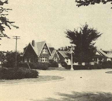


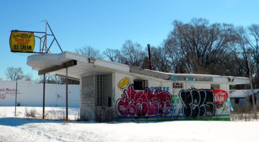
8 Neighborhood Character Past Present 1) Source: Google Maps 1) Source: All other images) Source: Practicum Team
9 Strengths, Weaknesses, Opportunities, Threats (S.W.O.T.) Analysis


10 STRENGTHS Gompers Elementary Brightmoor Community Center Source: Poor infrastructure High vacancy rates Source: Practicum Team WEAKNESSES


11 OPPORTUNITIES Urban agriculture Local grassroots art Source: Source: Practicum Team Further decline of commercial corridor Source: Google Maps THREATS
12 Socioeconomic Profile Total Population, Racial Composition, Household Income, Educational Attainment, Employment Status, Summary

13 Fenkell Corridor Focus Area Census Tracts Source: ESRI
14 Fenkell Corridor Focus Area Total Population Brightmoor Detroit Michigan ,815 34, ,270 9,938, ,742 23, ,777 9,883,640 %Δ -41% -31% -25% -1% Sources: 2000, 2010 U.S. Census


15 Racial Composition Fenkell Corridor Focus Area 2.9% 6.7% Brightmoor 3.3% 9.8% 90.4% 86.9% White Alone Black or African American Alone Other Race 6.2% Detroit 11.6% White Alone Black or African American Alone Other Race 6.7% Michigan 14.0% 82.2% 79.3% White Alone Black or African American Alone Other Race White Alone Black or African American Alone Other Race Source: ACS Year Estimate
16 2.2% 3.5% 1.2% 0.4% 0.0% 7.0% 2.6% 0.9% 0.8% 0.1% 6.2% 3.2% 1.6% 1.1% 0.6% 7.3% 4.1% 3.7% 3.0% Percent of Total Households 11.3% 9.0% 17.8% 20.4% 16.6% 12.9% 14.3% 13.2% 20.4% 19.7% 17.1% 14.7% 18.7% 11.9% 38.6% 39.4% 54.6% Household Income Distribution Fenkell Corridor Focus Area Brightmoor Detroit Michigan Less than $20,000 $20,000 to $34,999 $35,000 to $49,999 $50,000 to $74,999 $75,000 to $99,999 $100,000 to $124,999 $125,000 to $149,999 $150,000 to $199,999 Source: ACS Year Estimate
17 4.1% 1.5% 0.5% 7.7% 2.7% 0.6% 7.4% 3.7% 1.3% 2.7% 11.3% 15.7% 7.2% Percent of Population 21.0% 22.8% 26.3% 31.2% 34.1% 33.4% 32.7% 32.2% 30.7% 32.4% 36.8% 40.0% Educational Attainment, People 25 and Older 35.0% 30.0% 25.0% 20.0% 15.0% 10.0% 5.0% 0.0% Fenkell Corridor Area Brightmoor Detroit Michigan Less Than High School Some college Master's degree High School Graduate (includes equivalency) Bachelor's degree Professional school / Doctorate degree Source: ACS Year Estimate
18 7.8% 18.0% 17.2% 14.8% Percentage of Total Population 36.0% 40.9% 39.0% 54.0% 53.8% 54.4% 58.2% 62.3% 70.0% Employment Status 60.0% 50.0% 40.0% 30.0% 20.0% 10.0% 0.0% Fenkell Corridor Area Brightmoor Detroit Michigan In Labor Force Employed Unemployed Source: ACS Year Estimate
19 Socioeconomic Summary Highest percentage of total population loss at 41% Largest racial group: African American at just over 90% Nearly 55% of household earn less than $20,000 annually Approximately 4% of residents earn Bachelor s degrees 26% of residents did not receive a high school diploma Highest current unemployment: 18%
20 Market Analysis Current Industry Profile, Industry Surpluses & Leakages
21 Current Industry Profile 24.40% 14.90% 4.60% 56.10% Retail Trade Finance, Insurance, Real Estate Services Other Source: 2012 ESRI Business Segment Concentration

22 Industry Surpluses & Leakages Surpluses Convenience stores Gas stations Liquor stores Leakages: Grocery stores Source: Practicum Team Lawn / garden equipment and supplies stores Used merchandise stores
23 Parcel Inventory Assessment Assessment Tool, Findings, Parcel Inventory
24 Assessment Tool Example Vacant Parcel Score Criteria General Parcel Condition Extreme and obvious environmental concerns, significant large debris, extreme brush growth, requires significant remediation (heavy equipment, specialized labor) Obvious but correctable environmental concerns, considerable debris, tall unkempt brush growth, requires considerable remediation (dedicated human labor) Minor environmental concerns, light debris or litter, intermittently maintained vegetation, requires light remediation (minor human labor) No environmental concerns, no debris or significant litter, well maintained vegetation, requires little or no remediation (ready for development)
25 Assessment Tool Parcel Score 0 to 4 5 to 9 10 to to 18 Lot requires large landowner and government investments to be considered for economic development. Lot generally in poor condition, requires significant landowner and government investment to be considered for economic development. Lot in serviceable condition, needs minor landowner and government investment to be considered for economic development. Lot in good condition, prime development potential. Requires little to no investment for economic development.
26 Assessment Tool Structure Score 0 to 4 Completely unserviceable, recommend deconstruction. 5 to 9 Structure requires significant investment to be serviceable. 10 to to 18 Structure requires little to moderate investment to be serviceable. Structure is ready to be utilized as is. No investment required.

27 Findings Vacant Parcel Condition

28 Findings Vacant Structure Condition
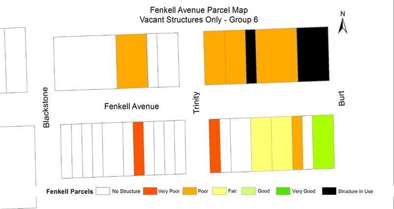
29 Parcel Inventory Vacant Structure Not Structure In Total Parcel In Use Use Parcels Group 1 3 (8.3%) 17 (47%) 16 (44%) 36 Group 2 7 (23.3%) 8 (26.7%) 15 (50%) 30 Group 3 3 (12%) 6 (24%) 16 (64%) 25 Group 4 14 (60.8%) 2 (8.7%) 7 (30.4%) 23 Group 5 24 (82.8%) 4 (13.8%) 1 (3.4%) 29 Group 6 16 (57.1%) 10 (35.7%) 2 (7.1%) 28

30

31
32 General Corridor Recommendations 1 Year, 1-3 Years, 3-5 Years
33 General Corridor Recommendations Low Cost Medium Cost High Cost Non-structural blight removal Major façade improvements Assisting local businesses Minor façade improvements (paint/signage) for existing businesses in use with advertisement Minor or 1 Year Inform community of development on corridor Update existing bus signage Notify possible developers of structures ready for business targeted sidewalk improvements based on walking audit results


34 Sidewalk Example Source: Google Maps Source:
35 General Corridor Recommendations Low Cost Medium Cost High Cost Inform community of development on Clear alleyways of debris and/or Demolition/ Structural blight corridor blight removal 1-3 Years Gateways to direct traffic into corridor Supplement current businesses with advertising, signage, and Community land acquisition general improvements


36 Gateway Example Source: Google Maps Source:
37 General Corridor Recommendations Low Cost Medium Cost High Cost 3-5 Years Inform community of development on corridor Present possible developers with parcel inventory data, funding sources, and economic analysis data Pedestrian safety signage/lighting Major sidewalk improvements focusing on total reconstruction Development of industries: Building materials and supply dealers, lawn and garden equipment and supplies, health and personal care, used merchandise, grocery/specialty food stores

38 Sidewalk Lighting Example Source: Google Maps Source:


39 Acknowledgements Joe Rashid, Kirk Mayes Brightmoor Alliance & Brightmoor Community Members Dr. Zenia Kotval Dr. Rex LaMore Michigan State University
40 Questions?
Site Map. Meadowlark Dr & Robinhood Rd, Winston Salem, NC, October 31, Esri
 Site Map Robinhood Village Meadowlark Dr & Robinhood Rd, Winston Salem, NC, 27106 Ring: 1, 3, 5 Miles Latitude: 36.120508 Longitude: -80.367204 October 31, 2011 2011 Esri Executive Summary Ring: 1, 3,
EDC ADDENDUM to the INTERIM REPORT
 EDC ADDENDUM to the INTERIM REPORT Economic Impact Assessment of Mansfield Park November 2018 STEWARDSHIP STRATEGIES Design Planning Historic Preservation Economic Development INTERIM REPORT - Economic
Retail MarketPlace Profile
 Retail MarketPlace Profile Drive Time: 5 minute radius Longitude: -77.40323 Summary Demographics 2015 Population 8,394 2015 Households 3,199 2015 Median Disposable Income $38,578 2015 Per Capita Income
Cumberland Comprehensive Plan Town Council adopted August 2003, State adopted June 2004 TABLE OF CONTENTS
 TABLE OF CONTENTS I. Executive Summary A. Scope of the Comprehensive Plan I-2 B. Plan Development Process I-3 C. Plan Format I-3 D. Acknowledgements I-4 II. Demographic Analysis A. Introduction II-1 B.
Demographic and Income Profile
 Demographic and Income Profile Summary Census 21 212 217 Population 3,718 3,985 4,362 Households 1,316 1,418 1,571 Families 1,128 1,212 1,336 Average Household Size 2.82 2.81 2.77 Owner Occupied Housing
City of Melissa Comprehensive Plan Update
 City of Melissa Draft: April 1, 2015 TABLE OF CONTENTS Chapter 1: Existing Conditions Analysis Introduction... 1.1 Demographic Characteristics... 1.3 Housing Characteristics... 1.22 Land Use Characteristics...
Idora: Creating a Smaller Stronger Neighborhood Thriving Communities Ohio Land Bank Conference
 Idora: Creating a Smaller Stronger Neighborhood Thriving Communities Ohio Land Bank Conference Wednesday, November 28, 2012 11:10am to 12:00pm Ian J. Beniston YNDC YNDC Ian Beniston, Deputy Director Youngstown
Remington-Holland Corridor Revitalization Cathedral District Saginaw, Michigan
 Remington-Holland Corridor Revitalization Cathedral District Saginaw, Michigan Daniel Beard Annie Matouka Jennifer McGrath Devon Munsell Emily Petz Bradley Sherman Stephanie Willavize Jie Yan Spring 2008
Joint Meeting City Council and the Plan Commission. September 1st, 2015
 Joint Meeting City Council and the Plan Commission September 1st, 2015 1 The City Plan Commission shall recommend a City Plan for the physical development of the City Article IX Section 2 of the City of
Chapter 1: Introduction
 Chapter 1: Introduction The Penn Avenue Community Works Corridor Vision and Implementation Framework presents an integrated communitybased vision and a coordinated, long-term implementation framework for
SECTION 1 Introduction...1. SECTION 2 Regional Context Criteria for Planning Districts Description of Planning District...
 Table of Contents SECTION 1 Introduction...1 SECTION 2 Regional Context...2 2.1 - Criteria for Planning Districts...2 2.2 - Description of Planning District...2 SECTION 3 Goals & Objectives...5 SECTION
Downtown Dubuque...it s a great time.
 Downtown Dubuque...it s a great time. Your timing could not be better to invest in Downtown. With hundreds of millions in public and private investment occurring on the City s downtown waterfront, millions
A community focused on developing a strong foundation with sustainable achievements. Special Acknowledgements: S. Robert Kaufman (Capstone Mentor),
,") A community focused on developing a strong foundation with sustainable achievements. Special Acknowledgements: S. Robert Kaufman (Capstone Mentor), Southwest Partnership Presenter: Molline C. Jackson Spring
A community focused on developing a strong foundation with sustainable achievements. Special Acknowledgements: S. Robert Kaufman (Capstone Mentor), Southwest Partnership Presenter: Molline C. Jackson Spring
Retail / Office - Available on Busy Florence Ave.
 Retail / Office - Available on Busy Florence Ave. 1931-1935 Florence Ave. Los Angeles, CA 90001 DEMOS 1 mile 3 mile 5 mile Population 62,398 489,568 1,146,128 Avg. HH Income $43,380 $44,533 $45,775 Daytime
Sustainably Repositioning Greyfield Sites. Greyfield Sites Anywhere
 Sustainably Repositioning Greyfield Sites Jim Constantine Looney Ricks Kiss Architects Todd Poole 4ward Planning Greyfield Sites Anywhere Pennsylvania Chapter American Planning Association Conference 2009
Kensington Center. Public Meeting # Transit-Oriented Development, Town of Berlin, CT
 Kensington Center Public Meeting #1 10.27.16 Transit-Oriented Development, Town of Berlin, CT CivicMoxie 2016 What is Transit-Oriented Development Definition: Transit-Oriented Development (TOD) = is an
Atlanta BeltLine Subarea 3 Master Plan Update
 Atlanta BeltLine Subarea 3 Master Plan Update April 14, 2018 Workshop Meeting 1 22 miles, connecting 45 neighborhoods 22 MILES of transit 46 MILES of streetscapes and complete streets 33 MILES of urban
Michigan City Alternative Analysis Realignment Study. Progress Status Update Report Presentation to City Council February 1, 2012
 Michigan City Alternative Analysis Realignment Study Progress Status Update Report Presentation to City Council Project Web Site Project Web Site is Active www. emichigancity.com Click on NICTD logo at
Table of Contents. Elm Avenue Improvement Plan City of Waco, Texas. Introduction 1. Existing Context 1 Figure 1 2.
 Table of Contents Introduction 1 Existing Context 1 Figure 1 2 Plan Guidelines 3 Future Urban Form 4 The West-End 4 Main Street 6 The East-End 7 Figure 2 9 Public Improvement Recommendations 7 General
City of Long Beach. creating vibrant and exciting places
 City of Long Beach creating vibrant and exciting places Land Use Element Urban Design Element Overview of the two draft General Plan elements Discuss areas of change Economic goals of the plans Case study
EXHIBIT A. Tax Increment Reinvestment Zone No. 1 (Town Center) First Amended Project Plan 1
 First Amended Project Plan 1") EXHIBIT A Tax Increment Reinvestment Zone No. 1 (Town Center) First Amended Project Plan 1 1 As amended by Resolution No. 2008-02-001(TR1R) of the Tax Increment Reinvestment Zone No.1, and approved to
EXHIBIT A Tax Increment Reinvestment Zone No. 1 (Town Center) First Amended Project Plan 1 1 As amended by Resolution No. 2008-02-001(TR1R) of the Tax Increment Reinvestment Zone No.1, and approved to
RETAIL PROPERTY FOR LEASE RYLAND PLAZA Ryland Pike, Huntsville, AL Clinton Avenue Suite 501 Huntsville, AL deancre.
 1001 Ryland Pike, Huntsville, AL 35811 2101 Clinton Avenue Suite 501 Huntsville, AL 35805 deancre.com 1001 RYLAND PIKE, HUNTSVILLE, AL 35811 EXECUTIVE SUMMARY OFFERING SUMMARY Available SF: 1,000-2,000
International Blvd. TOD Plan Public Workshop #1
 International Blvd. TOD Plan Public Workshop #1 Add photos or project images September 21 and 22, 2010 Workshop Purpose Introduce the public to the Project Review and discuss the existing conditions analysis
Boston Square Planning & Design Project Grand Rapids, Michigan
 Boston Square Planning & Design Project Grand Rapids, Michigan Joseph Calhoun, Elise Fields, Joseph Manzella, Colin Pahl, Jay Roberts, Kent Sugiura, Erin Whitney, Holly Zoe Prepared for UP 494/894 Urban
Making Transit Oriented Development Work For Boonton, NJ
 Making Transit Oriented Development Work For Boonton, NJ Bloustein School of Planning and Public Policy Studio Dan Burton Loannie Dao Webster Slater Brandon Williams Ian Watson Maria Laham Nicola Mammes
Town Center (part of the Comprehensive Plan)
") Town Center (part of the Comprehensive Plan) Mercer Island Town Center Looking North (2014) In 1994, a year-long process culminated in a set of design guidelines and code requirements for the Town Center
Town Center (part of the Comprehensive Plan) Mercer Island Town Center Looking North (2014) In 1994, a year-long process culminated in a set of design guidelines and code requirements for the Town Center
KARNS, TENNESSEE 5.7 Acres Available Located on Oak Ridge Highway Excellent Development Opportunity!
 KARNS, TENNESSEE 5.7 Acres Available Located on Oak Ridge Highway Excellent Development Opportunity! DIXON GREENWOOD, CCIM Ball Realty & Auction, Inc. P.O. Box 237, Tazewell, TN 37879 423-626-9393 office
The Auburn Plan Designing the Future of Auburn February 28, 2005
 The Auburn Plan Designing the Future of Auburn February 28, 2005 Block-by-Block Bicycle Tour Aerial survey Focus Group Meetings September 7 and 8 Design Workshops October 11, 14, and 21 Revitalization
REGIONAL ACTIVITY CENTER
 DRAFT REGIONAL ACTIVITY CENTER 70 EAST BENCH MASTER PLAN DRAFT 06 Introduction The East Bench Regional Activity center is comprised of large educational, research, medical, and employment centers. These
Pace University Land Use and Sustainable Development Conference Tensions and Opportunities in Urban Revitalization
 Pace University Land Use and Sustainable Development Conference Tensions and Opportunities in Urban Revitalization Ken Schwartz, Principal, VHB December 6, 1013 Pace University Land Use and Sustainable
Implementation Guide Comprehensive Plan City of Allen
 Implementation Guide 2030 Comprehensive Plan City of Allen DRAFT 2015 Implementation Guide Allen 2030 Comprehensive Plan INTRODUCTION The Comprehensive Plan serves as a guide for the growth and development
THE POLICY FRAMEWORK FOR WALKABLE COMMUNITIES. Community Technical Assistance Program Building Active Communities Institute March 2016
 THE POLICY FRAMEWORK FOR WALKABLE COMMUNITIES Community Technical Assistance Program Building Active Communities Institute March 2016 ACTIVE COMMUNITIES BACK THEN ACTIVE COMMUNITIES BACK THEN Lifestyle
4- PA - LD - LIVELY DOWNTOWN. LD - Background
 4- PA - LD - LIVELY DOWNTOWN LD - Background The downtown has been the service centre for the community since the city s inception and the area continues to supply people with their personal services,
Danvers High Street I-1 District Study
 Danvers High Street I-1 District Study Presentation of Final Recommendations Planning Board Presentation June 26 th, 2018 1 Introductions Metropolitan Area Planning Council Sam Cleaves AICP, Principal
Planning Districts INTRODUCTION
 INTRODUCTION To facilitate detailed examination of development prospects for all areas of the community, Delano has been divided into 14 planning districts. The location of these planning districts is
BAGBY STREET RECONSTRUCTION PROJECT OCTOBER 2, 2015
 BAGBY STREET RECONSTRUCTION PROJECT OCTOBER 2, 2015 CLAIRE HEMPEL, PLA, AICP, LEED GA PREPARED BY Aspen Asheville Austin Chicago Denver Dubai Houston Lake Tahoe Los Angeles MIDTOWN : A MODEL OF URBAN DEVELOPMENT
The GATEWAYS Sub Area Master Plan. City of Walker
 The GATEWAYS Sub Area Master Plan City of Walker Introduction: The Walker City Commission and Planning Commission decided in 2011 to create a sub-area master plan for the Remembrance Road and Wilson Avenue
Land Use Amendment in Southwood (Ward 11) at and Elbow Drive SW, LOC
 at and Elbow Drive SW, LOC") 2018 November 15 Page 1 of 10 EXECUTIVE SUMMARY This land use amendment application was submitted by Rick Balbi Architect on 2017 August 31 on behalf of Sable Developments Ltd, and with authorization from
2018 November 15 Page 1 of 10 EXECUTIVE SUMMARY This land use amendment application was submitted by Rick Balbi Architect on 2017 August 31 on behalf of Sable Developments Ltd, and with authorization from
LUNDY S LANE COMMUNITY IMPROVEMENT PLAN STUDY
 PUBLIC INFORMATION MEETING #2 October 12, 2016 LUNDY S LANE COMMUNITY IMPROVEMENT PLAN STUDY AGENDA 5:00 to 5:30pm: Open House 5:30 to 6:15pm: Presentation 6:15 to 7:00pm: Individual paced workshop with
SECOND FLOOR STUDIO AVAILABLE ON VENTURA BLVD
 SECOND FLOOR STUDIO AVAILABLE ON VENTURA BLVD Located at 13563 1/2 Ventura Blvd, Sherman Oaks, CA 91423 DEMOS 1 mile 3 mile 5 mile Population 24,151 187,734 519,845 Avg. HH Income $121,056 $109,474 $101,327
Dyersville Downtown Plan. Open House October 24, 2017
 Dyersville Downtown Plan Open House October 24, 2017 What is a Comprehensive Plan? - Vision - Guidance for decisions - Basis for regulations What is a Downtown Plan? - Understand priorities - Identify
hermitage town center
 hermitage town center A Community Vision prepared by Strada for The City of Hermitage and The Mercer County Regional Planning Commission January 2007 table of contents introduction 3 design principles
4.1.3 LAND USE CATEGORIES
 4.1.3 LAND USE CATEGORIES a. City Center District The City Center District incorporates the existing character and mix of uses in downtown Belmont to encourage redevelopment and new development in keeping
ROBBINSDALE LRT STATION CDI DEVELOPMENT GUIDELINES
 August 2018 OVERVIEW The City of Robbinsdale has a prime-opportunity site in the middle of the 13 mile stretch of the Bottineau LRT corridor / Blue Line extension. Robbinsdale offers a prominent, vital,
SUMMERSIDE / MT. CARMEL REINVESTMENT CORRIDOR COMMUNITY DEVELOPMENT STRATEGY
 SUMMERSIDE / MT. CARMEL REINVESTMENT CORRIDOR COMMUNITY DEVELOPMENT STRATEGY FEBRUARY 2013 I. Location of the Summerside/Mt. Carmel Reinvestment Corridor The Summerside/Mt. Carmel Reinvestment Corridor
12 th Street Connector Alignment Study VISIONING PUBLIC WORKSHOP - JUNE 25, :00PM TO 8:00PM
 12 th Street Connector Alignment Study VISIONING PUBLIC WORKSHOP - JUNE 25, 2018 6:00PM TO 8:00PM Goals for Today s Workshop Agenda: Project Introduction, Purpose, and Goals Existing Conditions Traffic
A BLUEPRINT FOR BROCKTON A CITY-WIDE COMPREHENSIVE PLAN
 A BLUEPRINT FOR BROCKTON A CITY-WIDE COMPREHENSIVE PLAN Public Meeting October 2016 1 Plan Summary and Discussion Public Meeting May 4 2017 City of Brockton Bill Carpenter, Mayor Department of Planning
SECTION ONE: INTRODUCTION. introduction
 introduction 1 INTRODUCTION Since it was first established in 1843 as a trading post for the Hudson s Bay Company, Victoria has evolved into a Provincial capital city that is recognized across Canada and
East Central Area Plan
 East Central Area Plan Steering Committee Meeting March 8 th, 2018 CHUN Tears McFarlane House Vision Statement Development Opportunities Analysis Vision Elements 1. Equitable, Affordable and Inclusive
Cumberland Region Tomorrow is a private, non-profit, citizen based regional organization working with Greater Nashville Regional Council
 Cumberland Region Tomorrow is a private, non-profit, citizen based regional organization working with Greater Nashville Regional Council and others in the public and private sectors, dedicated to planning
City of Bristol Route 6 Corridor Implementation Program
 City of Bristol Route 6 Corridor Implementation Program FITZGERALD & HALLIDAY, INC. Innovative Planning, Better Communities June 2017 Route 6 Corridor Plan IMPLEMENTATION PROGRAM The following Implementation
8implementation. strategies
 PROGRAM STRATEGIES 8implementation strategies T he implementation actions of this chapter are designed to support and carry out the land use, economic development, transportation, urban design, and program
LAND USE OVERVIEW WHAT YOU WILL FIND IN THIS CHAPTER
 LAND USE WHAT YOU WILL FIND IN THIS CHAPTER Information about the City s expected population and employment growth. Description and capacity of existing and future land use designations. Policies that
Urban Development Areas Albemarle County
 1 Urban Development Areas Albemarle County UDA Needs Profile: All UDAs Albemarle County has two UDAs: the Pantops UDA located east of the Rivanna River and the City of Charlottesville, and Places 29 South,
COMMUNITY DESIGN. GOAL: Create livable and attractive communities. Intent
 COMMUNITY DESIGN Intent An attractive, well-designed County will attract quality development, instill civic pride, improve the visual character of the community, and create a strong, positive image for
TUSTIN RED HILL DEVELOPMENT TUSTIN CITY COUNCIL WORKSHOP
 TUSTIN RED HILL DEVELOPMENT TUSTIN CITY COUNCIL WORKSHOP 7-6-15 CONTEXT MAP PREVIOUS CHURCH AND ADJACENT RETAIL SITE EXISTING RETAIL CENTER SITE CONDITIONS PREVIOUS SITE CONDITIONS PREVIOUSLY APPROVED
GPA FALL 2017 CONFERENCE
 Change in Doraville Doraville at the beginning of a new era Design Doraville (Comp. Plan) adopted in 2016 Doraville Town Center Masterplan LCI (2005) Downtown Doraville Masterplan LCI (2010) 2014 Adoption
12/9/2013. HOLLYWOOD/PINES CORRIDOR PROJECT AMPO 2013 Annual Conference October 24, Our Perspective. Broward.
 HOLLYWOOD/PINES CORRIDOR PROJECT AMPO 2013 Annual Conference October 24, 2013 Our Perspective Broward Fort Lauderdale 1 Broward Metropolitan Planning Organization Fort Lauderdale Fort Lauderdale Skyline
East Central Area Plan
 East Central Area Plan Steering Committee Meeting January 10 th, 2019 Tears-McFarlane House Community Room East Central Area Plan Steering Committee Meeting January 10 th, 2019 CHUN Tears-McFarlane House
TOD 101 CREATING LIVABLE COMMUNITIES WITH TRANSIT
 1 CREATING LIVABLE COMMUNITIES WITH TRANSIT What are transit Centered Communities? Benefits of Partnerships to Support and Implement What You Will Learn Portland s Pearl District Your Trainers Today Catherine
CHAPTER 3 VISION, GOALS, & PLANNING PRINCIPLES. City of Greensburg Comprehensive Plan. Introduction. Vision Statement. Growth Management Goals.
 CHAPTER 3 VISION, GOALS, & PLANNING PRINCIPLES Introduction The Greensburg Comprehensive Plan is intended as a working community document. A combination of long and short-term goals, this document is intended
ITEM #8. Regional Smart Growth Program. Regional Smart Growth Program. Presentation Overview. Coast Highway Vision and Stategic Plan.
 Regional Smart Growth Program Economic Development Commission What is Smart Growth? Adopted as part of the Regional Comprehensive Plan (RCP) RCP provides vision for region based on Smart Growth and sustainability
Retail space for lease? Take a closer look at the coin laundry business.
 Retail space for lease? Take a closer look at the coin laundry business. Introducing a collaborative program to fill vacancies with a Wascomat Commercial Laundry Center, a world-class, reliable and innovative
Long Lost Allies? Walking Advocates & Business District Organizations. Matt Kazinka Lake Street Council. Shaina Brassard Seward Redesign
 Long Lost Allies? Walking Advocates & Business District Organizations Shaina Brassard Seward Redesign Rob Hanson West Broadway Business and Area Coalition Matt Kazinka Lake Street Council Jamie Schumacher
and services The protection and conservation of environmentally significant and sensitive natural heritage features and functions.
 6. Land Use 6.0 Preamble A healthy and livable city is one in which people can enjoy a vibrant economy and a sustainable healthy environment in safe, caring and diverse neighbourhoods. In order to ensure
The Lincoln Neighborhood Corridor Plan. The LiNC
 October 1, 2014 Planning Commission Study Session The Lincoln Neighborhood Corridor Plan The LiNC Purpose of Tonight s Meeting Introduction to The LiNC Review of Existing Conditions and Community Identified
Roosevelt Corridor. R e i n v e s t m e n t P l a n. Public Meeting Gilbert Elementary School May 12, :00 pm
 Roosevelt Corridor R e i n v e s t m e n t P l a n Public Meeting Gilbert Elementary School May 12, 2009 6:00 pm Agenda 6:00 6:10 6:25 6:40 6:55 7:00 Opening Comments Councilwoman Jennifer V. Ramos District
Status Update (2006 vs. Now) Citizen s Advisory Committee February Plan for Prosperity
 Citizen s Advisory Committee February Plan for Prosperity") Status Update (2006 vs. Now) Citizen s Advisory Committee February 2018 Plan for Prosperity 2000 2017 2000 2017 Gardnerville Population 6,000 5,760 5746 5,500 5,000 5,067 5,550 5,165 5,394 5,412 5,250
Status Update (2006 vs. Now) Citizen s Advisory Committee February 2018 Plan for Prosperity 2000 2017 2000 2017 Gardnerville Population 6,000 5,760 5746 5,500 5,000 5,067 5,550 5,165 5,394 5,412 5,250
Town of Peru Comprehensive Plan Executive Summary
 Town of Peru Comprehensive Plan Executive Communities that plan grow by choice, not by chance. A plan makes growth thoughtful, understandable, and predictable. A plan shows that a community is managing
DRAFT Land Use Chapter
 Stevens Creek Urban Village DRAFT 1 18 17 Land Use Chapter INTRODUCTION This Land Use Chapter describes how the Stevens Creek Urban Village will accommodate the growth that is planned for it in the Envision
BUDGETING FOR OUTCOMES TRINITY RIVER CORRIDOR
 BUDGETING FOR OUTCOMES TRINITY RIVER CORRIDOR Trinity River Corridor Team Members: Kelly High, Streets Department Megan Lam, Office of Financial Services Mike Mikeska, Dallas Water Utilities Diana Ochoa,
A Plan Enhancement Process for the Future of Howard Design Studio 2 May 28-30, The Howard Plan
 A Plan Enhancement Process for the Future of Howard Design Studio 2 May 28-30, 2011 The Howard Plan West of Pinecrest Future Land Use Plan Velp Corridor Land Use Analysis & Recommendations Duck Creek /Quarry
Plano Tomorrow Vision and Policies
 Plano Tomorrow Vision and Policies PLANO TOMORROW PILLARS The Built Environment The Social Environment The Natural Environment The Economic Environment Land Use and Urban Design Transportation Housing
In the heart of the Southern Sector is a diamond in the rough
 WESTMORELAND DART STATION AREA PLAN Map III-2.24 The Westmoreland DART Station Area In the heart of the Southern Sector is a diamond in the rough the Westmoreland Transit Station. This DART station, near
URBAN DESIGN BRIEF NORTHVIEW FUNERAL HOME HIGHBURY AVE N, LONDON, ON
 URBAN DESIGN BRIEF NORTHVIEW FUNERAL HOME - 1490 HIGHBURY AVE N, LONDON, ON 1.1Purpose The intent of the following report is to identify an opportunity for redevelopment of two residential properties within
Take a closer look at the coin laundry business
 Retail space for lease? Take a closer look at the coin laundry business Introducing a collaborative program to fill vacancies with an Electrolux Laundry Center, a globally recognized brand name anchor.
A citizen s guide to the. Comprehensive Plan. City of Lakeville, Minnesota 1
 A citizen s guide to the Comprehensive Plan 2008 City of Lakeville, Minnesota 1 Introduction The City of Lakeville completed an update of its Comprehensive Plan in 2008. A comprehensive plan is a tool
Robbinsdale LRT Station. CDI Development Guidelines. August Overview
 Robbinsdale LRT Station August 2018 Overview The City of Robbinsdale may have the coolest opportunity site along the 13 mile stretch of the Bottineau LRT corridor / Blue Line extension. Located a block
EXISTING PLANS Harriet Festing Center for Neighborhood Technology Midlothian Community Meeting March 12, 2015
 EXISTING PLANS Harriet Festing Center for Neighborhood Technology Midlothian Community Meeting March 12, 2015 BENEFITS Bring economic, community + environmental benefits Enhance property values Use
Committee Meeting: Downtown Today & Concept Refinement September 11, 2017
 Committee Meeting: Downtown Today & Concept Refinement September 11, 2017 AGENDA 1. Brief Input Update 2. Comprehensive Plan Principles 3. Downtown Today 4. Concept Updates 5. Future Schedule What is a
FUNDING CORRIDOR REVITALIZATION
 FUNDING CORRIDOR REVITALIZATION Integrated corridor planning for the 21 st Century America Planning Association Annual Conference Atlanta, GA April 27, 2014 Mariia Zimmerman, MZ Strategies, LLC mariia@mzstrategies.com
Acknowledgements. Port St. Lucie CRA Master Plan. City of Port St. Lucie City Council
 DRAFT Acknowledgements City of Port St. Lucie City Council Robert E. Minsky, Mayor James E. Anderson, Vice Mayor Patricia P. Christensen Jack Kelly Glenn H. Magrane Special thanks to: St. Lucie County
TEMPLE MEDICAL & EDUCATION DISTRICT
 City of Temple, Texas TEMPLE MEDICAL & EDUCATION DISTRICT 1 Description. The City of Temple joined in partnership with key public and private entities to jointly promote education and medical activities
2030 Comprehensive Plan VISION STATEMENT
 RESOURCE DOCUMENT for Steering Committee Meeting #2 July 12, 2017 2030 Comprehensive Plan VISION STATEMENT Steering Committee from 2008 Established the Lauderdale s Vision as: Creating a livable, lovable
FOR LEASE CORNERSTONE BANK BUILDING SIZE DESCRIPTION LLOYD COMPANIES $18.50 / SF NNN 1,588-3,835 SF. 69th & Louise RAQUEL BLOUNT, SIOR 605
 6045 S Louise Avenue Sioux Falls, SD 57108 FOR LEASE $18.50 / SF NNN 1,588-3,835 SF SIZE Suite A: 1,588 SF Suite B: 2,247 SF DESCRIPTION PRICE $18.50 / SF NNN TIA: $40.00 / SF Class A first generation
12600 S Existing Conditions
 STUDY AREA BOUNDARY Study Area Boundary Study Area Context The District Riverton Meadows Vista Station Mountain View Village Market Center 2 Mile Radius 12600 S Existing Conditions 12600 S is a river of
Table L-1 Summary Action Strategy. Action Item Timing Status Responsible Agency
 CHAPTER 4: CIRCULATION ELEMENT ISSUE #1: MAJOR THOROUFARES AND TRANSPORTATION ROUTES A balanced transportation system for Fontana is provided that meets the mobility needs of current and future residents
.33 AC AC RETAIL LAND FOR SALE OR BUILD TO SUIT ORCHARD ROAD & OAK STREET, NORTH AURORA, IL 60542
 Development Opportunity.33 AC - 6.74 AC RETAIL LAND FOR SALE OR BUILD TO SUIT ORCHARD ROAD & OAK STREET, NORTH AURORA, IL 60542 OFFERING SUMMARY Price / Acre: See Enclosed Pricing Summary Lot Size:.33
The transportation system in a community is an
 7 TRANSPORTATION The transportation system in a community is an important factor contributing to the quality of life of the residents. Without a sound transportation system to bring both goods and patrons
Real Estate/Economic Considerations
 Real Estate/Economic Considerations Why a Market Study? Understand demographic trends & real estate market conditions Translate growth forecasts into New housing Workplace uses Hotel/lodging Retail & supporting
Silverdale Regional Center
 Silverdale Regional Center Vision for Silverdale Regional Center The Silverdale Regional Center Plan (Plan) will guide the evolution of the Silverdale Regional Center from a collection of strip malls and
RESOURCE PACKET River Crossing
 RESOURCE PACKE River Crossing Overall Project Focus: "River Crossing" project is funded through an NEA Our own grant that provides a comprehensive plan for public art and arts experiences that will connect
ANC 2A Presentation. November 9, 2006
 ANC 2A Presentation November 9, 2006 Introduction & Overview Applicants Boston Properties and KSI Services (project developers) The George Washington University (land owner) 2.66 acre site (former GW hospital
Business-Facts Summary - Workplace Business and Employment
 - Workplace Business and Employment Title Page Title Page Data Version: 2018 Feb (Internal) Report Generation Method: Single Analysis Area: 1789 STATE ST, SAN DIEGO, CA, 92101-2530 Reporting Detail: As
WATERFORD Plan of Preservation, Conservation and Development Supplement Part 1 - Policy Element
 WATERFORD 2012 Plan of Preservation, Conservation and Development 2015 Supplement Part 1 - Policy Element Effective June 11, 2015 2015 Plan Update GOAL To respond to the evolving land use needs and continually
Retail MarketPlace Profile
 Drive Time: 5 minute radius Longitude: -86.79066 Summary Demographics 2015 Population 10,596 2015 Households 4,648 2015 Median Disposable Income $55,009 2015 Per Capita Income $47,446 Industry Summary
Retail MarketPlace Profile
 Ring: 1 mile radius Latitude: 32.35365 Summary Demographics 2016 Population 7,400 2016 Households 3,138 2016 Median Disposable Income $41,269 2016 Per Capita Income $24,267 Industry Summary (Retail Potential)
3598 OLD JENNINGS RD 3598 Old Jennings Rd, Middleburg, FL 32068
 LAND FOR SALE 3598 OLD JENNINGS RD 3598 Old Jennings Rd, Middleburg, FL 32068 PROPERTY FEATURES 7.69 Acres at Lighted intersection Adjacent Properties are Zoned MPC, School & Retail NC Across Tynes Water
CHAPTER 7: VISION AND ACTION STATEMENTS. Noble 2025 Vision Statement
 CHAPTER 7: VISION AND ACTION STATEMENTS This chapter presents the vision, policy and action statements that transform the comprehensive planning study, an analysis of Noble s past, future trends and community
Chicago Neighborhoods 2015: Assets, Plans and Trends A project of The Chicago Community Trust
 NORTHWEST SIDE Jefferson Park Milwaukee/Lawrence Corridor Study August 2008 Community Areas: Jefferson Park Department of Planning and Development, Skidmore, Owings & Merrill LLP, Applied Real Estate Analysis,