FOREWORD TO THE POOLBEG PLANNING SCHEME BY THE CHAIRMAN
|
|
|
- Wilfrid Lee
- 5 years ago
- Views:
Transcription
1 Draft Poolbeg Planning Scheme December 2008
2 FOREWORD TO THE POOLBEG PLANNING SCHEME BY THE CHAIRMAN Introduction On behalf of the Dublin Docklands Development Authority, I am very pleased to welcome you to the public consultation stage on the Draft Planning Scheme for an area of the Poolbeg peninsula. The Authority received, in 2007, an Order from the Minister of Environment Heritage and Local Government that was supported unanimously by the Oireachtas, directing us to prepare this Draft Planning Scheme. Since that time, the Authority has worked hard, meeting with interested stakeholder groups, to capture their vision for the area and to understand their concerns. In particular however, I want to thank the very many residents from Sandymount, Irishtown, Poolbeg and Ringsend area, who came to our many workshops and voiced their concerns and contributed in such a constructive way towards the new Draft Planning Scheme. This 62 day long public consultation period, is a vitally important stage in the preparation of the Draft Planning Scheme. We invite you to review this document, visit one of the displays in the area, and to make any submissions or comments you have to the Authority. The Authority, and its consultant team will carefully review and consider all your submissions and will amend or modify the Draft, prior to submitting the document to the Minister of Environment Heritage and Local Government for approval. I assure you that your views are very welcome and will be taken very seriously. Issues of Concern in the Draft Poolbeg Planning Scheme We thought it would be helpful if I was to highlight some of the specific issues that we know are of concern in relation to the Poolbeg scheme and to set out our approach to addressing those concerns. Transport We are aware that traffic and transportation issues are of major concern to residents. All would accept that transport and travel issues throughout the city are a challenge for any Planning Authority or Agency and Poolbeg is no different. Concerns feature heavily on the increase in the number of cars going through the area. Will there be gridlock into and out of Poolbeg? Will there be an improvement in Public Transport into the area? These are all very real concerns. Public transport improvements are an essential part of the Draft Planning Scheme in order to permit development to proceed, as well as walking and cycling. Our most important response is the innovation in the Draft Planning Scheme for the establishment of a new DRT (Docklands Rapid Transport), which goes someway towards meeting the immediate transport challenges as well being part of a long term solution. The DRT is essentially a high quality/high frequency bus based system. Innovative measures such as cycle share system, the use of car pooling, car clubs, and water based transport are encouraged.
3 DRAFT POOLBEG PENINSULA PLANNING SCHEME In relation to existing traffic, the Draft Planning Scheme requires improvements to the road network to reduce the impact of the proposed development on adjacent roads. It is also a requirement of the Draft Planning Scheme that a Luas link, or a similar high capacity line, will need to be delivered in order to implement the latter phase of the Draft Planning Scheme. Flooding The issue of flooding will be of concern to residents. A flood risk assessment has been carried out by the design teams and they have planned for measures, such as raising the ground floor of all buildings above flood levels, and ensuring that sea water levels do not breach the peninsula s infrastructure. You will have an opportunity during the public display to meet with our planners and put your concerns directly to them. Building Height and Densities Building heights, densities will also be of concern to local residents. It is important where we are building in urban areas to build sustainable densities, which are well served by public transport. The Draft Planning Scheme ensures that the density of building is spread fairly across the entire site, based on sound planning reasons. Within the Draft Planning Scheme building heights will be set to an upper limit. We have deliberately omitted any high rise towers in this scheme as we feel it is important to maintain a medium rise development and have designed a height strategy that ensures that as many people as possible benefit from the views across Dublin Bay and the river, and while respecting the adjacent residential and public open space areas. All applicants are required to demonstrate daylight, sunlight and shadow impact assessment on existing and proposed residential development and on existing and proposed open spaces. The Authority has a very strong commitment to architectural quality and legacy. The Draft Planning Scheme encourages excellence in design and therefore another of the Scheme requirements is that all development proposals are subject to a design review process. Sustainable Development The Authority has included new ground breaking measures to ensure the best international practices in sustainable development are included in the scheme. For example, reuse of rain water, district heating, high quality low energy buildings, well managed open spaces, play spaces for children, cycle lanes, and a high emphasis on recycling and waste management. The Draft Planning Scheme requires applicants to fill in a Sustainability Toolkit that sets out
4 FOREWORD TO THE POOLBEG PLANNING SCHEME BY THE CHAIRMAN required performance levels for sustainable measures. In fact for the first time in Ireland, a sustainability certification system is included in the scheme. Community Facilities and Community Gain The Authority has in its 2008 Master Plan committed the Authority to providing community gain and provision of community facilities in tandem with development. We have listened to the Community s concerns that Community facilities should be delivered in parallel with commercial and residential developments. The Authority in this Draft Planning Scheme, will ensure that this will happen. Throughout the drafting of this scheme, the Authority has consulted with members of the Community and Public Representatives to identify the prioritised Community Gain needs for the area in the future. Following this consultation, the main Community Gain facilities to be provided under the Draft Planning Scheme proposals include: - Contributions to the Docklands Community Trust - A Community Centre - Community Youth facilities - Community Play Facilities - A Community Arts/Cultural Centre - A Heritage and Biodiversity Centre The Authority intends securing this gain for the Community s through the introductions of a new type of community development scheme. Through this scheme, developers will be required to deliver from the prioritised list Community Gain projects in the area based on each phase of development. This is in addition to the Authority ensuring the continued provision of 20% social and affordable housing which it first introduced in the Master Plan Local Employment Charter Another important objective as set out in our Act is to promote and the development of employment in the Docklands Area. One of the major new changes to this draft Planning Scheme is the stated intention of the Authority to reserve discretion to include the Local Employment Charter as a condition of the Section 25 certificate. Through this development the Authority hopes to be in a position to encourage the provision of 20% employment for local residents. Land Ownership Some people have questioned us being able to give ourselves certificates of compliance with the Planning Scheme. Further, in all of the Planning Schemes areas within Docklands the Authority has owned land on which it has
5 DRAFT POOLBEG PENINSULA PLANNING SCHEME made a Planning Scheme and awarded itself Section 25 planning approval. Indeed, as a developing Authority, this has enabled us to achieve greater control over the successful development of the land to deliver on community development, education, employment, civic infrastructure, social and affordable housing deficits and architectural legacy to ensure that the long-term sustainability of Docklands is secured. Indeed, this was why the power to purchase land and to give ourselves planning was specifically included in our founding legislation. It is also very relevant that the Authority s part purchase of the former Irish Glass Bottle site in the Draft Poolbeg Planning Scheme area was at the specific request of members of the Council. The site was purchased by Becbay Ltd, a company owned jointly by the Authority and a consortium of Developers. Our Shareholders Agreement provides the Authority with a 26% interest in the property. When purchasing this site, the Authority insisted that its primary focus was good planning and development, community gain and good infrastructure and the Authority is committed to delivering this. Section 25 Procedures You may be aware of the recent High Court judgement in relation to North Lotts and wonder how this affects the Authority and the preparation of this Draft Planning Scheme and its Section 25 procedures. The Authority has introduced amendments to the Section 25 planning process that allow for an additional level of consultation, specifically aimed at residents, land and property owners in the area. Full details of this new process are available on the Docklands website. The Authority has decided to introduce a practical step to avoid any apprehension of bias involving Section 25 applications where the Authority has a property interest in the land. Where applications are made for certification in respect of such lands, the Authority will obtain an opinion from an external planner which the Authority will have regard to in coming to a decision on such application. Conclusion While addressing the above issues of concern to all our stakeholders, I must emphasise that the statutory consultation period is only starting with the publication of this Draft Planning Scheme and all concerns and issues will continue to be addressed through further consultation over the minimum period of 62 days. I genuinely hope you find the Scheme exciting and progressive. All the members of the Authority s Board and Council look forward to receiving your views on how best we can deliver a Poolbeg Planning Scheme which meets the majority of your concerns and needs and make Poolbeg a great place to live, a great to work and a great place to visit. Donal O Connor Chairman December 2008
6 FOREWORD TO THE POOLBEG PLANNING SCHEME BY THE CHAIRMAN
7 DRAFT POOLBEG PENINSULA PLANNING SCHEME Statutory Instrument No. 297 of 2007 DUBLIN DOCKLANDS DEVELOPMENT AUTHORITY ACT 1997 (SECTION 25 PLANNING SCHEME) OR- DER 2007 The Minister for the Environment, Heritage and Local Government, in exercise of the powers conferred on him by Section 25(1) of the Dublin Docklands Development Authority Act, 1997 (No.7 of 1997), hereby specifies the area described in the schedule to this Order as an area for which the Dublin Docklands Development Authority may prepare a planning scheme under Section 25 of the said Act. SCHEDULE In this Schedule Unless otherwise specified, any reference to a line drawn along any bridge, railway track, river, road or street, shall be construed as a line drawn along the centre of such bridge, railway track, river, road or street, as the case may be. The part of the county borough of Dublin bounded by a line commencing at the point (hereinafter in this description referred to as the first-mentioned point) where the River Liffey is intersected by the northerly projection of Thorncastle Street, then continuing in a southerly direction along the said projection and Thorncastle Street to the point where it joins York Road, then continuing in an easterly direction where it intersects with the roundabout at Sean Moore Road and continues in a south-westerly direction along Sean Moore Road to the point where it intersects with Beach Road and continues in a south-easterly direction along Beach Road to the point where it is joined by Marine Drive, then continuing in a north easterly direction in a straight undefined line to the point where it intersects with the high water mark of Dublin Bay along the south eastern boundary of Sean Moore Park, then continuing, initially in a north easterly direction, along the said high water mark to the point where it first adjoins the southern side of the Great South Wall, then continuing due north along a line to the point where it intersects the high water mark on the northern side of the Great South Wall, then continuing, initially in a westerly direction, along the last-mentioned high water mark for a distance of 373 metres, then turning due south and continuing to the intersection point with Pigeon House Road then continuing in a westerly direction along Pigeon House Road for 492 metres, then continuing due north for 55 metres and turning west for 60 metres, then north for 71 metres, north west for 67 metres then north-east for 185 metres, then turning north along a projected line until it intersects with the high water mark and
8 STATUTORY INSTRUMENT NO. 297 OF 2007 continuing along said high water mark until a point where it intersects with the northerly projection of the junction between Pigeon House Road and an undefined access road immediately west of the cooling pond for the Synergen plant, then turning south to the intersection with Pigeon House Road then continuing in an easterly direction for 467 metres along Pigeon House Road to the intersection point with the access road to the Water Treatment Plant, then in a southerly direction along the eastern boundary of the access road for 63.5 metres, then in an easterly direction for 275 metres and then turning due south and continuing for 245 metres, then continuing in a westerly direction for 558 metres to the intersection point of Shelly Banks Road, then turning north along Shelly Banks Road for 106 metres, then turning west for 15 metres, then continuing in a south westerly direction for 75 metres before turning west for 90 metres, then south for 82 metres to the intersection with South Bank Road, then turning west for 215 metres along South Bank Road, then turning north for 344 metres to the intersection point with Pigeon House Road, then continuing west for 84 metres to the intersection point with Whitebank Road, then west for 287 metres to the intersection point with the northern spur of South Bank Road and continuing west to the intersection with Pigeon House Road, then continuing for 198 metres to the end of Pigeon House Road, then continuing along a northwesterly projection to the intersection point of the high water mark to the south west of the Marina and continuing along the last mentioned high water mark to the point where it joins the East Link Bridge, then continuing in a westerly direction to the first mentioned point. GIVEN under my Official Seal, 11 June 2007 DICK ROCHE, Minister for the Environment, Heritage and Local Government
9 DRAFT POOLBEG PENINSULA PLANNING SCHEME EXECUTIVE SUMMARY 1.0 INTRODUCTION THE POOLBEG PLANNING SCHEME STATUTORY BACKGROUND PLANNING POLICY CONTEXT VISION AND OBJECTIVES GENERAL NOTES ON THE PLANNING SCHEME 2.0 CONTEXT THE POOLBEG PENINSULA PLANNING SCHEME ZONES URBAN CHARACTER AND ANALYSIS MOVEMENT FRAMEWORK NATURAL ENVIRONMENT HISTORIC ENVIRONMENT SERVICES AND INFRASTRUCTURE DEVELOPMENT CONSTRAINTS 3.0 OVERALL DESIGN THEMES AND LANDSCAPE FRAMEWORK DESIGN THEMES BUILDING WITH NATURE BUILDING WITH HERITAGE LANDSCAPE FRAMEWORK NATURE AND EXTENT OF PROPOSED DEVELOPMENT AMOUNT OF DEVELOPMENT DEVELOPMENT ZONES DISTRIBUTION OF DENSITY POLICIES 5.0 DISTRIBUTION AND LOCATION OF USES OVERALL LAND USE RESIDENTIAL DEVELOPMENT OFFICE AND ENTERPRISE DEVELOPMENT DEVELOPMENT OF RETAIL AND NON-RETAIL SERVICES CULTURAL, LEISURE, ENTERTAINMENT AND TOURISM DEVELOPMENT PROVISION OF COMMUNITY FACILITIES AND COMMUNITY GAIN PROVISION OF NEW PUBLIC OPEN SPACE, SPORT, RECREATION AND PLAYSPACE POLICIES 6.0 OVERALL DESIGN PRINCIPLES URBAN STRUCTURE AND GRAIN URBAN SCALE ARCHITECTURAL QUALITY AND EXTERNAL FINISHES SPECIAL BUILDINGS SUSTAINABLE DESIGN DEISGN REVIEW POLICIES
10 CONTENTS TRANSPORT AND MOVE- MENT MOVEMENT STRATEGY PUBLIC TRANSPORT CYCLING AND WALKING ROAD NETWORK PARKING STANDARDS TRANSPORT IMPACT ASSESSMENTS TRAFFIC MANAGEMENT POLICIES 8.0 ENVIRONMENTAL AMENITIES AND ARCHITECTURAL HERITAGE ENVIRONMENT STRATEGY HERITAGE STRATEGY POLICIES 9.0 INFRASTRUCTURE, FLOOD PROTECTION AND REMEDIATION INFRASTRUCTURE FLOOD PROTECTION REMEDIATION POLICIES 10 DELIVERY AND IMPLEMENTA- TION GENERAL APPROACH ENABLING AND SUPPORTING DEVELOPMENT DEVELOPMENT PHASES FUNDING AND DELIVERY PHASED IMPLEMENTATION PROJECTS REQUIRED OUTSIDE THE PLANNING SCHEME BOUNDARY SUSTAINABILITY TOOLKIT APPLICATIONS FOR CERTIFICATION LOCAL EMPLOYMENT CHARTER CONSTRUCTION OF DEVELOPMENT POLICIES APPENDICES APPENDIX 1: DAYLIGHTING AND SUNLIGHTING STANDARDS APPENDIX 2: PARKING STANDARDS APPENDIX 3: GUIDELINES FOR THE PREPARATION OF MOBILITY MANAGEMENT PLANS APPENDIX 4: REPORT ON SITE CONTAMINATION REQUIREMENTS APPENDIX 5: SUSTAINABILITY TOOLKIT APPENDIX 6: CONTENT OF APPLICATION FOR SEC- TION 25 CERTIFICATE APPENDIX 7: LOCAL EMPLOYMENT CHARTER GLOSSARY IMAGE CREDITS TEAM

11
12
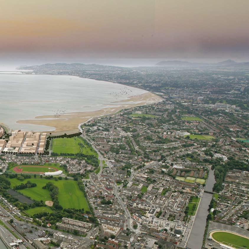
13 DRAFT POOLBEG PLANNING SCHEME EXECUTIVE SUMMARY 12 Preface The Poolbeg Peninsula occupies a historic gateway location on Dublin Bay at the mouth of the River Liffey, near to the established neighbourhoods of Ringsend, Sandymount and Irishtown. With substantial areas of developable land, it is in a unique position to help meet Dublin s growing needs, and provides an outstanding opportunity to create a new sustainable living and working community within 2km of O Connell Bridge. In recognition of its potential, a Ministerial Order has been granted for the designation of much of the peninsula for the preparation of a Draft Section 25 Planning Scheme. Poolbeg is, and always was, important to Dublin. It contains a significant cluster of historic structures including the former Pigeon House Power Station, Hotel and Dock together with the remains of the Fort. Now the peninsula is home to many of the city s major power, sewage, storage and port facilities. Its iconic chimneys are widely visible in the Dublin region. The peninsula contains valued open space, including Sean Moore Park and Irishtown Nature Park, whilst its southern shore opens on to Dublin Bay, recognised by a number of European environmental designations. The Planning Scheme will provide the framework to deliver long-term social, economic, planning and environmental benefits for Dublin. Overall the potential development floorspace within will be in the region of 750,000 square metres. This equates to a potential residential population of 10,100 people and potential working population of 16,000 people. The Planning Scheme seeks excellence in urban design, architecture and the public realm. It will include environmental, landscape and public realm improvements and will promote accessible and attractive public open spaces. Transport improvements are an essential and integral part of the Planning Scheme. The road network in the area is congested and it is essential that it promotes sustainable means of transport walking, cycling, and public transport. The Planning Scheme places heavy emphasis on the provision of quality public transport in the form of a Docklands Rapid Transit system and a proposed Luas service (or equivalent high capacity public transport service). The Planning Scheme will contain a district centre, a local centre and a full range of community facilities including education and health facilities to support the living and working community on the peninsula and the neighbouring areas of Ringsend, Irishtown and Sandymount. The community facilities will be provided as an integral part of the development and phasing will ensure that they are provided at the right time. Phasing is thus connected with the creation of inte-
14 EXECUTIVE SUMMARY grated communities and is equitable in terms of its relationship to land ownership. The Planning Scheme will be in conformity with the Dublin Docklands Area Master Plan (2008), which is the statutory framework for Dublin Docklands. National, regional and local planning policies have also informed the preparation of the Planning Scheme and particular regard has been had to Ireland: National Climate Change Strategy (2007); Sustainable Residential Development in Urban Areas Consultation Draft Guidelines for Planning Authorities (February 2008), which is a current statement of Government policy relating to residential development; and the Urban Design Manual (February 2008), which is a best practice companion guide to the draft guidelines. Sustainability is a defining theme of the Master Plan and is inherent in all policies and delivery and implementation mechanisms. All development which is part of the Planning Scheme will be subject to sustainability assessment against a Sustainability Toolkit (see section 10.0). The Planning Scheme is supported by an Environmental Impact Assessment. The Planning Scheme has been prepared with full community engagement which has taken place in advance of the formal process of statutory consultation. Regular meetings were held with the local community and there were ongoing discussions with a special interest group set up to look at and comment on the emerging proposals in more detail. This consultation has been invaluable in informing the Planning Scheme during the process of its development and production. Vision The overall vision for Poolbeg is: To create an urban waterside quarter that facilitates sustainable and consolidated growth of Dublin City and articulates a new relationship between the city and the Bay. The quarter will provide for commercial, residential, cultural and amenity uses, whilst balancing the essential industrial and infrastructural requirements of the area. The recreational and amenity potential will be enhanced through a landscape and environmental framework, which optimises the natural resources of the peninsula. 13
15 DRAFT POOLBEG PLANNING SCHEME 14 Planning Scheme Zones The Planning Scheme boundary covers over 90 hectares, but excludes port operations, industrial and utilities plants which will continue in operation. The land intended for comprehensive redevelopment within the Planning Scheme is about 40 hectares and this is divided into four Development Zones. The plot ratio for the areas of the Planning Scheme intended for comprehensive redevelopment, taken as a whole, will be about 2.0:1, with an overall land use mix of 60 percent to 70 percent residential floorspace to 30 percent to 40 percent commercial floorspace. Both plot ratio and development mix will however differ significantly for each of the Development Zones and these will be applied through policies in the Planning Scheme, with a degree of flexibility in the mix of uses. An indicative guideline density of 247 dwellings per hectare will apply to Zones 1, 2 and 4, and 150 dwellings per hectare in Zone 3. The development components of the Planning Scheme are as follows. Zone 1 Zone 1 comprises the former Irish Glass Bottle land (10.1 hectares) and the adjacent Fabrizia land (4.6 hectares). This will become a mixed use neighbourhood which will include residential, commercial and retail development, including a district centre of up to 20,000 square metres net retail floorspace. This Zone will have a relatively high development density with a plot ratio of 2.5:1 to 3.0:1 and a mix of 60 percent residential to 40 percent commercial (with 10 percent flexibility to increase the residential provision). Zone 1 will contain the Luas stop. It will also contain an important new park, the Dublin Bay Valley Park, which will be a centrepiece for the development and will connect the built up area with the southern shore of the peninsula and beach. Development in Zone 1 will generally be in the form of larger blocks with internal courtyards. The district centre will focus on an urban plaza fronted by taller, slender buildings marked by a landmark building of 15 storeys together with a special building incorporating a public use. The area between Dublin Bay Valley and Sean Moore Park will be a mainly residential neighbourhood, with community facilities including a primary school, and small neighbourhood parks. A variety of building heights will be employed on the Sean Moore Park frontage. Parking for retail and office units will mainly be underground. Within Development Zone 1, the former Irish Glass Bottle land is currently in the ownership of a consortium known as BECBAY, of which the Authority has membership of 26 percent. Zone 2 A 1.2 hectare strip of port-owned land just to the north of Zone 1. This will be an area for commercial development (100 percent commercial) with a relatively high density. Plot ratios will be within a range of 2.8:1 to 3.3:1. It will benefit from a high level of public transport accessibility and reasonably
16 EXECUTIVE SUMMARY close proximity to the district centre. Development in Zone 2 will be in the form of a row of larger, individually-designed blocks. Zone 3 An area of approximately 11 hectares under the ownership of Dublin Port, on the peninsula s southern shore. Development in this Zone will maximise the potential offered by a prominent position overlooking Dublin Bay. The northern part adjacent to the utilities will be partly devoted to logistics and the remainder will be a family friendly neighbourhood. The area will have an overall ratio of 90 percent residential to 10 percent commercial (allowing for 10 percent flexibility up or down) with an informal and varied architectural character and much lower plot ratios of 0.5:1 to 1.0:1. To the north of the spine road, development will consist of medium to fine grain apartments and to the south, low-rise fine grain development with a range of townhouse, patio house and beach pavilion building types. There will be constructive interplay between topography and underground parking, with ground floor levels rising away from Dublin Bay to facilitate views to the south. Zone 4 A 2.5 hectare area around Pigeon House Dock dominated by a number of iconic buildings and structures including the former Pigeon House Power Station, Pigeon House Hotel and the Dock itself. Currently in Dublin City Council ownership, it will provide a focal point for heritage, arts, culture and media uses, with an 80 percent to 20 percent residential to commercial mix (allowing for 10 percent flexibility up or down) and will have a medium density of 1.1:1 to 1.6:1. Development in Zone 4 will comprise three strong architectural clusters of buildings. Firstly, the Pigeon House Power Station is proposed to be refurbished with contemporary additions to the rear to accommodate new uses. The adjacent Pigeon House Hotel is also proposed to be refurbished. The proposed building to the south of the Hotel should ensure that the view of the primary façade of the hotel from Green Hill is respected. Secondly, there will be a commercial cluster of up to seven buildings which are arranged around a central covered atrium. Thirdly, there will be a series of larger-scale modern buildings north of Pigeon House Park. Open Space Open space within the Planning Scheme includes Sean Moore Park, Irishtown Nature Park, land near the wastewater treatment works, and land at the eastern extremity of the peninsula. These areas will not form part of the development area but will be critical to the overall landscape framework, which is based upon an appreciation of the natural features of the peninsula. The Planning Scheme will include a green chain of continuous and accessible public ways which will take in these spaces and give access to a range of different kinds of experience: sports, leisure, ecological, wetland, shoreline and beach. 15
17 DRAFT POOLBEG PLANNING SCHEME 16 The Planning Scheme will also include new and improved open spaces. Dublin Bay Valley Park will be a wedge shaped public space that will provide views and access to the Dublin Bay from the central part of the development in Zone 1. The southern shore will be improved as a public recreational resource, Beach Park, whilst ensuring that there is no impact on the designated conservation areas. A linear, ecological park, South Shore Green, will be located between the Synergen power station and Zone 3 to orientate development towards the Dublin Bay and to provide an appropriate edge to the industrial development. In Zone 4, the Waste Water Treatment Plant overflow tanks will be required to be covered to provide a focal green open space for the cluster of development in the Pigeon House area. Urban Design The Planning Scheme policies aim to promote excellence in urban, architectural and landscape design. The Planning Scheme promotes a finer grain of development compared with some of the recent development in Docklands. In order to enhance street interest and provide a vibrant mix of uses, office buildings must accommodate transparent office entrance lobbies or atriums and integrate shops, cafés, leisure activities and other microeconomic activities which each have their own front door access. Residential streets will also have clearly defined apartment and duplex entrances fronting the street to create ground level interest and natural surveillance of the street. The Planning Scheme will require all development proposals to demonstrate architectural diversity. Architectural style and design should be varied and may be introduced through design, materials, colour, building height and detail. Within each block of development, no more than 10,000 square metres of development may be designed by one architect. A high standard of design will also be required in the design of the streets, spaces and the public realm within the Planning Scheme. The Planning Scheme will encourage excellence in design and therefore, all development proposals will be subject to design review. Exceptionally high architectural and placemaking qualities will be sought for schemes which are to achieve the upper half of the plot ratio range in each development area; and exceptionally high architectural and placemaking qualities will be sought for special buildings and buildings in the 14 to 15 storey height band. In addition, to develop within the upper half of the plot ratio range in each development area, applications must also achieve high sustainability performance standards through the achievement of a Gold Commendation in the Sustainability Toolkit and must implement playspaces in excess of the Authority s Play Space Guidelines. Building heights are set by means of a height strategy consisting of a set of height bands which will apply to each plot of development within the Planning Scheme. The heights have been determined by taking into account urban design, the mix of uses, air quality and daylighting and sunlighting fac-
18 EXECUTIVE SUMMARY tors. The upper number of storeys in the height band applying to a plot is the maximum building height permitted on that plot. This maximum height applies to the whole building; setbacks, penthouses and substantial roof level plant all count as storeys. The highest building within the Planning Scheme will be 15 storeys. The height strategy takes into account the results of the air quality modeling of emissions from the existing and proposed industrial installations on the peninsula. All buildings should have a taller ground-floor storey height, to create attractive and appropriately scaled entrance, reception and living spaces. The minimum height for ground floor storeys of commercial, retail and public buildings is 4.5 metres. All buildings should have underground car parking, unless there are justifiable reasons otherwise, to ensure car parking does not dominate the street space nor provide inactive frontages onto streets. Section 25 Applications are required to be assessed against the daylighting, sunlighting and shadow standards set out in appendix 1. The Planning Scheme also defines a small number of special buildings for which exceptionally high architectural and design quality is required. The buildings are special, either through their position within the Planning Scheme or their proposed use. The nature of the special buildings should inform their design. The most important of these is the former Pigeon House Power Station itself. This should be sensitively refurbished to accommodate new public uses such as an art gallery, museum, cultural centre, exhibition space or a media centre to which the public would have some access. A sympathetic extension to the rear of the former power station could be provided to accommodate complementary uses such as a gallery/museum shop and café, archive and gallery space, meeting rooms and lettable workspace/offices units. Housing Size and Quality Policies within the Planning Scheme will ensure that residential development provides a wide mix of dwelling types, sizes and tenures to ensure that a sustainable residential environment is created. A minimum of 25 percent of units are to be of 3 bedrooms or above (5 percent of these are encouraged to be four bedrooms and above), and 20 percent of all residential development must be social and/or affordable housing, which should be indistinguishable from market housing and distributed throughout the development. All units will be fully accessible. Policies will require that the space standards and other requirements of the Achieving Liveable, Sustainable New Apartment Homes policy of Dublin City Council, Variation 21, are complied with. The Planning Scheme encourages the provision of familyoriented dwellings. It seeks a high proportion of homes with access to outdoor private open space, such as an outdoor 17
19 DRAFT POOLBEG PLANNING SCHEME 18 garden, balcony or outdoor terrace and a high proportion with its own front door access. It also seeks a high proportion of traditional houses with gardens and duplexes/large apartments with outdoor space in areas such as Zone 3, which has a lower density and access to public open space. The Planning Scheme encourages innovative house typologies, such as house-over-house and patio houses (where the house occupies an entire plot, with open space and car parking contained within the volume of the building), where they would provide housing suitable for families. Self building is also encouraged, particularly in Zone 3. Scheme will also require childcare facilities to be provided in accordance with Child Care Facilities Guidelines For Planning Authorities (2001). In addition to these, the Authority will seek a range of other community gain facilities, which will support the new community on the peninsula and the existing communities nearby. Those currently identified include community childcare facilities, a community centre, community youth facilities, heritage centre, biodiversity centre and a cultural/arts facility. Further facilities may be identified by the Authority as considered necessary, appropriate and reasonable. Community Facilities and Community Gain The district centre in Zone 1 will provide significant shopping and community facilities not only for the new development on the peninsula, but also for the existing communities of Irishtown, Ringsend and Sandymount. Policies in the Planning Scheme require it to be laid out on a street-based format rather than an indoor arrangement. A local centre in Zones 3 will also be provided. A range of community facilities will be provided within the Planning Scheme. Policies will require that developers reserve land for schools, and will require the direct provision of other community facilities in association with site development. This applies to the primary health care facility, doctors and/ or dentists surgeries, a library and a post office. The Planning The Authority will also require financial contributions from developers to a community gain levy. This will comprise contributions to (a) the Community Trust Fund, which has been established by the Authority as a sustainable, independent source of finance to support innovative and creative projects in the community sector and (b) community recreational facilities, which will cover the provision and/or enhancement of community sports facilities and the provision of community playspaces, including a playground on Sean Moore Park. Consultation with local residents, community representatives and key stakeholders has been undertaken to inform proposals for the provision of community facilities and community gain.
20 EXECUTIVE SUMMARY Sustainable Development Water supply and demand management are significant issues for the Greater Dublin area. The Planning Scheme Sustainability Toolkit has been designed with regard to the principles of sustainable water management. Developers will be required to adopt comprehensive water use reduction, conservation and reuse initiatives within the built environment, including sustainable urban drainage systems and rainwater recovery. The Planning Scheme Sustainability Toolkit promotes low energy, low carbon development. Electrical and thermal energy demand will be minimised by means of a design strategy with higher standards than the existing Building Regulations together with the utilisation of heat and electricity from existing and future resources on the peninsula. The Toolkit encourages the use of passive design strategies, renewable energy technologies and energy/heat recovery techniques. The Planning Scheme Sustainability Toolkit promotes the use of natural and recovered, sustainably-sourced, safe and durable materials with a low embodied energy. It also encourages building design techniques that allow for end of life deconstruction with components that are easy to recover, reuse and recycle. A policy of sourcing building materials from the locality is also encouraged, where practicable. residual waste at centralised locations for apartment blocks and commercial businesses and adequate space and access will be provided in all units for the separation and movement of waste streams. A target of 90 percent recycling and re-use will be set for developments. The Planning Scheme Sustainability Toolkit requires that developers must have due regard for the provisions of the Greater Dublin Strategic Drainage Study and CIRIA Sustainable Urban Drainage Guidelines and provide evidence in the form of a Sustainable Drainage Strategy, incorporated into the Stormwater Attenuation Plan, demonstrating how best practice has been followed. In addition to the specific environmentally-related standards set out above, developments within the Poolbeg Planning Scheme area will be required to provide sustainable living and working environments, adhering to standards for the creation of comfortable and safe buildings and surroundings. All buildings should be accessible to persons with disabilities, have comfortable internal environments in terms of daylighting and sunlighting and noise protection standards and should be designed to minimise the opportunities for crime. 19 As regards waste management, the Planning Scheme Sustainability Toolkit gives priority to waste prevention and reduction followed by re-use and then recycling. Facilities will be provided for mixed dry recyclables, biodegradable waste and
21 DRAFT POOLBEG PLANNING SCHEME 20 Transport and Movement The Planning Scheme aims to reduce the need to travel by providing residential and employment development alongside leisure and cultural development, community facilities, open space and major transport links. It also aims to maximise the use of sustainable transport modes. The movement strategy will support the provision of safe and efficient transportation and access to the area whilst minimising the impact of new development on local residents and other users of Dublin s transport network. The movement strategy has been developed on the basis that the following modal split will be achieved when all the proposed development is delivered: Public Transport: percent of journeys Walking: percent of journeys Cycling: 5-10 percent of journeys Internal Trips: 5-10 percent of journeys Car: A maximum of percent of journeys. services and the future Metro North line and Interconnector. The DRT will take advantage of the proposed public transport bridge across the mouth of the Dodder River. In later phases, it is intended that the Luas (or an equivalent high capacity public transport service) will be extended to Poolbeg and will vastly increase public transport carrying capacity on the peninsula. The new Luas line will be subject to detailed feasibility studies to determine the preferred alignment. The movement strategy aims to enhance the permeability of the area and improve the environment for pedestrians and cyclists. A network of routes will be implemented to improve connections to Ringsend, Sandymount, other parts of the Dublin Docklands, the city centre and wider area. Streets, public spaces and the public realm will be designed in a way that is accessible, convenient, attractive and safe for pedestrians and cyclists to use. Enhanced bus services will be required to be delivered at the outset of the development. This will support the initial public transport requirements. In the early phase, a high capacity bus based system the Docklands Rapid Transit (DRT) system will be required to be delivered to provide high frequency and high quality public transport connecting the Poolbeg peninsula with the city centre and major public transport nodes such as the Docklands, Tara Street and Pearse Street Rail Stations, existing bus The two main access points to the development will be from Sean Moore Road, one from the site of the existing Sean Moore roundabout and the other opposite Bremen Road. The Planning Scheme is designed with a road hierarchy which identifies primary, secondary and tertiary routes according to their function. Street profiles have been designed for each of the routes. Car parking will be mostly underground; policies will set the maximum amount of parking permitted. The standards are
22 EXECUTIVE SUMMARY restrictive to reflect the high level pf public transport which will serve the peninsula. Transport Impact Assessments (TIA) will be required to support Applications for Certification and Mobility Management Plans will be required for larger commercial proposals. Environment and Heritage The Planning Scheme aims to conserve and enhance the area s ecology and biodiversity (including habitats), complementing the existing nature conservation areas and creating new areas of ecological value and green spaces. The Planning Scheme will introduce new habitats and sustainable urban drainage systems will form part of the development. The landscape framework will be supported by a nature route, linking environmental destinations or nodes across the peninsula. The nature route is a walk along the Dublin Bay, from Strand Road and Sandymount Strand, along the southern shores of the peninsula to the South Bull Wall and the Poolbeg Lighthouse. The Planning Scheme will seek to encourage the appropriate conservation, interpretation and re-use of protected structures and monuments: Pigeon House Dock conservation Former Pigeon House Power Station conservation and reuse Pigeon House Hotel conservation and reuse Great South Wall conservation and interpretation Pigeon House Fort conservation and interpretation Infrastructure To facilitate the development of the peninsula and other developments, it is likely that a trunk main augmentation to this general area, from the Dublin City Council reservoir at Stillorgan, will be required. Strategically, DCC are also concerned about their ability to provide treated drinking water for the level of development now envisaged throughout the city and it is likely that a new supply of drinking water will be required. At the local level, upgrading and extension of the existing trunk water main is required during the first phase of development. New development on the peninsula is planned to drain to the Ringsend Waste Water Treatment plant, subject to available capacity, via a new network of foul sewers and a new sewage pumping station which will be delivered in Phase 1 of development. All new development will include appropriate provision for surface water infrastructure to serve new development. All developments proposed within the Planning Scheme area will be required by the Planning Scheme Sustainability Toolkit to connect to a district heating network where the opportunity is provided. District heating will ultimately allow the occupants and inhabitants of the Poolbeg peninsula to benefit from a more cost effective and environmentally friendly heat source than conventionally available. 21
23 DRAFT POOLBEG PLANNING SCHEME 22 A new electricity substation and associated network of medium voltage distribution lines, plus a new Bord Gais above ground pressure reduction station and associated local distribution mains will be delivered before Phase 2 of development proceeds. A high-speed electronic data transfer network is required to meet the needs of new enterprises and expectations of future residents. In order to guarantee a secure communications service, a telephone exchange building and associated feed cables will be delivered in Phase 1 of development. change will raise flood risk and it is recommended that future ground floor levels be designed based on a future tide height of at least 4.0m ODM (above the Irish Ordnance Survey Datum at Malin Head) or as may be required by Dublin City Council or the Office of Public Works. These requirements are incorporated into the Planning Scheme. All development proposals and landscape works will need to be rigorously assessed to ensure that they do not increase flood risk in any area, and reduce the risk where possible. Individual Flood Risk Assessments will be required for all development proposals to identify where site-specific flood protection works are necessary. It is anticipated that many development sites will have contaminated soil and groundwater arising from previous landfilling and heavy industrial uses. Developers will be required to carry out a full contaminated land risk assessment before development takes place and ensure that any contaminated soil or water encountered is appropriately dealt with. The Planning Scheme takes into account the presence of adjacent land covered by the Seveso II Directive, under the European Communities (Control of Major Accident Hazards Involving Dangerous Substances) Regulations (2006), situated on the Poolbeg peninsula. The Poolbeg peninsula is constructed from reclaimed and made ground. The ground level across much of the peninsula is relatively high, offering some level of protection against future flooding. Anticipated rises in sea level due to climate Phasing The implementation of development through the Planning Scheme is designed to ensure that delivery is equitable between major landowners and existing developers and that critical infrastructure is brought forward in tandem with development. The phasing strategy is based upon an approach which will deliver successful places within each phase of the development. A number of phases have been identified in the Planning Scheme, within which strategic infrastructure, including community facilities, public transport and utilities and telecommunications, will be delivered to enable and support the development.
24 EXECUTIVE SUMMARY 23
25
EVALUATION OF MASTER PLAN ALTERNATIVES
 7 The Environmental Report is required to identify, describe and evaluate reasonable alternatives, taking into account the objectives and geographical scope of the Master Plan 2008. Three plan alternatives
DUBLIN DOCKLANDS MASTER PLAN AND RELATIONSHIP WITH OTHER PLANS
 .1 National Policy and Programmes.1.1 Sustainable Development A Strategy for Ireland, 1997.1.2 National Climate Change Strategy, 2007-2012.1. National Development Plan 2007-201.1.4 National Spatial Strategy,
3.2 EXISTING LAND USE. Landscape & Urban Design Framework
 3.2 EXISTING LAND USE Landscape & Urban Design Framework 26 3.2 EXISTING LAND OWNERSHIP 27 Poolbeg Awakens 3.3 PLOTS CONSIDERED WITHIN PLANNING BOUNDARY plots within Planning Scheme Boundary Landscape
Poolbeg West SDZ Draft Planning Scheme
 Poolbeg West SDZ Draft Planning Scheme Introduction/vision Housing Community Economy/Employment Movement/transport Infrastructure green infrastructure /open space Land-use and phasing Public Realm Urban
NORTH CIRCULAR ROAD - REGENERATION IN ACTION
 NORTH CIRCULAR ROAD - REGENERATION IN ACTION Notting Hill Housing is a social enterprise which has been at the forefront of vibrant urban regeneration since 1963. Notting Hill has over 25,000 homes across
Keystone Business Park Precinct Structure Plan North East Industrial Precinct. Part 2 Design Principles
 Keystone Business Park Precinct Structure Plan North East Industrial Precinct Part 2 Design Principles Context Issues Services Landform Issues Geotech and contamination Ecology Traffic and access Issues
Welcome. Walk Around. Talk to Us. Write Down Your Comments
 Welcome This is an information meeting introducing the applications for proposed redevelopment of the Yorkdale Shopping Centre site at 3401 Dufferin Street and 1 Yorkdale Road over the next 20+ years,
Welcome to our exhibition
 Welcome to our exhibition The Homes & Communities Agency (HCA) welcomes you to this public exhibition explaining our proposals for the redevelopment of the former Lea Castle Hospital site. About the Homes
Newcourt Masterplan. November Exeter Local Development Framework
 Newcourt Masterplan November 2010 Exeter Local Development Framework Background The Exeter Core Strategy Proposed Submission sets out the vision, objectives and strategy for the development of Exeter up
Land Use Amendment in Southwood (Ward 11) at and Elbow Drive SW, LOC
 at and Elbow Drive SW, LOC") 2018 November 15 Page 1 of 10 EXECUTIVE SUMMARY This land use amendment application was submitted by Rick Balbi Architect on 2017 August 31 on behalf of Sable Developments Ltd, and with authorization from
2018 November 15 Page 1 of 10 EXECUTIVE SUMMARY This land use amendment application was submitted by Rick Balbi Architect on 2017 August 31 on behalf of Sable Developments Ltd, and with authorization from
Woodbrook - Shanganagh
 Section 4: Key Sites Framework Strategy Woodbrook - Shanganagh Local Area Plan 2017-2023 4. Site Framework Strategies The Master Plans shall have regard to the thematic objectives under the LAP Development
I615. Westgate Precinct
 I615. Westgate Precinct I615.1. Precinct Description The Westgate Precinct is located approximately 18km west of the Auckland city centre. There are seven Sub-precincts in the Westgate Precinct: Sub-precinct
URBAN DESIGN BRIEF URBAN DESIGN BRIEF 721 FRANKLIN BLVD, CAMBRIDGE August 2018
 URBAN DESIGN BRIEF URBAN DESIGN BRIEF 721 FRANKLIN BLVD, CAMBRIDGE August 2018 DESIGN BRIEF CONTENTS PART A 1.0 INTRODUCTION 2.0 DESCRIPTION & ANALYSIS OF SITE CONTEXT 3.0 DESIGN CONSTRAINTS AND OPPORTUNITIES
ELMVALE ACRES SHOPPING CENTRE MASTER PLAN
 ELMVALE ACRES SHOPPING CENTRE MASTER PLAN Contents 1.0 INTRODUCTION... 2 2.0 LOCATION... 2 3.0 EXISTING CONTEXT... 2 4.0 VISION & GUIDING PRINCIPLES... 2 5.0 LAND USE AND BUILT FORM... 4 5.1 St. Laurent
Former North Works, Lickey Road, Longbridge, Birmingham
 Committee Date: 14/11/2013 Application Number: 2013/06431/PA Accepted: 27/08/2013 Application Type: Full Planning Target Date: 26/11/2013 Ward: Longbridge Former North Works, Lickey Road, Longbridge, Birmingham
elbridge Core Strategy
 C elbridge Core Strategy Celbridge is designated as a Moderate Growth Town in the RPGs. The County Development Plan reinforces this designation in its settlement strategy. Moderate Growth Towns within
3.1 The hybrid planning application proposes the following description of development:
 CHAPTER 3: PROPOSED DEVELOPMENT 3.1 The hybrid planning application proposes the following description of development: Hybrid (part-outline/part-full) planning application for a single composite development
WHITELEY TOWN COUNCIL NORTH WHITELEY DEVELOPMENT SEPTEMBER 2014
 WHITELEY TOWN COUNCIL NORTH WHITELEY DEVELOPMENT SEPTEMBER 2014 Dear Resident This Special Edition of the Whiteley Voice which has been prepared in conjunction with the North Whiteley Consortium is to
1.0 Purpose of a Secondary Plan for the Masonville Transit Village
 Report to Planning and Environment Committee To: Chair and Members Planning & Environment Committee From: John M. Fleming Managing Director, Planning and City Planner Subject: Masonville Transit Village
Page 1 of 19 URBAN DESIGN FRAMEWORK FOR BOLTON STREET WATERFORD
 Page 1 of 19 URBAN DESIGN FRAMEWORK FOR BOLTON STREET WATERFORD 1.0 Introduction: The relocation of the City Council stores and depot from Bolton Street creates an exciting opportunity for development
4 RESIDENTIAL ZONE. 4.1 Background
 4 RESIDENTIAL ZONE 4.1 Background The residential areas within the City are characterised by mainly lowrise dwellings sited on individual allotments. Past architectural styles, settlement patterns and
Chapter 2: OUTLINE PLANNING APPLICATION PROPOSALS. A New Garden Neighbourhood Matford Barton 17
 Chapter 2: OUTLINE PLANNING APPLICATION PROPOSALS A New Garden Neighbourhood Matford Barton 17 2.1. SUMMARY AND STATUS OF THE PROPOSALS 2.1.1. The parameter plans and associated wording in this chapter
FORMER CANADIAN FORCES BASE (CFB) ROCKCLIFFE SECONDARY PLAN. Official Plan Amendment XX to the Official Plan for the City of Ottawa
 ROCKCLIFFE SECONDARY PLAN. Official Plan Amendment XX to the Official Plan for the City of Ottawa") FORMER CANADIAN FORCES BASE (CFB) ROCKCLIFFE SECONDARY PLAN Official Plan Amendment XX to the Official Plan for the City of Ottawa 1 INDEX THE STATEMENT OF COMPONENTS PART A THE PREAMBLE PAGE Purpose...
FORMER CANADIAN FORCES BASE (CFB) ROCKCLIFFE SECONDARY PLAN Official Plan Amendment XX to the Official Plan for the City of Ottawa 1 INDEX THE STATEMENT OF COMPONENTS PART A THE PREAMBLE PAGE Purpose...
599 Kennedy Road - Official Plan Amendment and Zoning Amendment Application - Preliminary Report
 STAFF REPORT ACTION REQUIRED 599 Kennedy Road - Official Plan Amendment and Zoning Amendment Application - Preliminary Report Date: March 7, 2017 To: From: Wards: Reference Number: Scarborough Community
6.0 Development of Amenities,
 6.0 Development of Amenities, conservation of architectural heritage and other features This chapter outlines the Area's significant potential to provide for amenities of city wide and local importance
DRAFT POOLBEG PLANNING SCHEME
 CONTEXT The Poolbeg Peninsula Planning Scheme Zones Urban Character and Analysis Movement Framework Natural Environment Historic Environment Services and Infrastructure Development Constraints 38 DRAFT
Official Plan Review: Draft Built Form Policies
 PG.30.1 REPORT FOR ACTION Official Plan Review: Draft Built Form Policies Date: May 15, 2018 To: Planning and Growth Management Committee From: Chief Planner and Executive Director, City Planning Division
YONGE STEELES CORRIDOR SECONDARY PLAN. Young + Wright / IBI Group Architects Dillon Consulting Ltd. GHK International (Canada) Ltd.
 Ltd.") PART A: PREAMBLE 1.0 PURPOSE The purpose of this Secondary Plan is to provide a development framework for intensification of the Yonge/ Steeles corridor including the north side of Steeles Avenue West
PART A: PREAMBLE 1.0 PURPOSE The purpose of this Secondary Plan is to provide a development framework for intensification of the Yonge/ Steeles corridor including the north side of Steeles Avenue West
GREENFORD HALL & ADJOINING LAND
 GREENFORD HALL & ADJOINING LAND CONTENTS 1. Introduction 1. Introduction 2. Urban Context 2.1 The Site and Surroundings 2.2 Urban Context Map 2.3 Access and Movement 3. Planning Context 3.1 Planning History
... on the draft Arden Vision & Framework
 April 2017 Integrated world-class urban renewal Feedback... on the draft Arden Vision & Framework On 1 September 2016 the Victorian Planning Authority (VPA) released the draft Arden Vision & Framework
PORT WHITBY COMMUNITY
 PORT WHITBY COMMUNITY SECONDARY PLAN UPDATE COMMUNITY IMPROVEMENT PLAN URBAN DESIGN GUIDELINES September 2015 DRAFT PROPOSED AMENDMENT NUMBER # to the Whitby Official Plan PURPOSE: The intent of this Amendment
Tāhuhu whakaruruhau ā-taone The sheltering ridge pole
 B2. Tāhuhu whakaruruhau ā-taone - Urban growth and form B2.1. Issues Tāhuhu whakaruruhau ā-taone The sheltering ridge pole Auckland s growing population increases demand for housing, employment, business,
BLETCHLEY PARK AREA - DEVELOPMENT FRAMEWORK
 ANNEX A To Item 9 REVISED TEXT: additions shown bold and underlined, deletions in (brackets and in italics). BLETCHLEY PARK AREA - DEVELOPMENT FRAMEWORK This framework sets out the key objectives and requirements
WATERLOO STATE SIGNIFICANT PRECINCT SUMMARY OF STUDIES
 WATERLOO STATE SIGNIFICANT PRECINCT SUMMARY OF STUDIES Technical studies will be undertaken to inform the master planning process for the Waterloo precinct to develop a Precinct Proposal to redevelop the
Place Brief. National Collections Facility (NCF site)
") Place Brief. National Collections Facility (NCF site) Contents 1.0 Purpose 2.0 Location and Proposal 3.0 Vision and Aim 4.0 Placemaking Principles 5.0 Conclusion Plan 1 Location Plan Plan 2 Placemaking
Place Brief. National Collections Facility (NCF site) Contents 1.0 Purpose 2.0 Location and Proposal 3.0 Vision and Aim 4.0 Placemaking Principles 5.0 Conclusion Plan 1 Location Plan Plan 2 Placemaking
Submission to Dublin City Council regarding the proposed Poolbeg West SDZ Planning Scheme
 Submission to Dublin City Council regarding the proposed Poolbeg West SDZ Planning Scheme 25 th July 2016 Introduction The Poolbeg West Strategic Development Zone (SDZ) was established by Government on
Welcome to our public exhibition
 About Our Scheme Welcome to our public exhibition This exhibition gives you the chance to view and comment upon our emerging proposals for a new residential development of 68 new homes on the site of the
EAST VILLAGE STRATEGIC SITE NOVEMBER 2017
 EAST VILLAGE STRATEGIC SITE NOVEMBER 2017 East Village will be a sustainable, mixeduse precinct with a focus on innovative employment and education opportunities. Enhanced by green spaces and places for
2.0 Strategic Context 4
 2.0 Strategic Context 4 2.1 The Area Action Plan is a non-statutory plan, which forms a corporate policy document, expressing particular issues and areas of concern while also providing a vision for the
INTRODUCTION NORTH HEYBRIDGE GARDEN SUBURB
 INTRODUCTION This event is being hosted by the promoters of the proposed North Heybridge Garden Suburb who are working with Maldon District Council and other key stakeholders on the preparation of a comprehensive
1071 King Street West Zoning Amendment Application - Preliminary Report
 STAFF REPORT ACTION REQUIRED 1071 King Street West Zoning Amendment Application - Preliminary Report Date: August 9, 2012 To: From: Wards: Reference Number: Toronto and East York Community Council Director,
(DC1) Direct Development Control Provision DC1 Area 4
 Direct Development Control Provision DC1 Area 4") . General Purpose (DC) Direct Development Control Provision DC Area 4 The purpose of this Provision is to provide for an area of commercial office employment and residential development in support of the
. General Purpose (DC) Direct Development Control Provision DC Area 4 The purpose of this Provision is to provide for an area of commercial office employment and residential development in support of the
Bloor St. W. Rezoning - Preliminary Report
 STAFF REPORT ACTION REQUIRED 1638-1644 Bloor St. W. Rezoning - Preliminary Report Date: April 1, 2008 To: From: Wards: Reference Number: Toronto and East York Community Council Acting Director, Community
Complete Neighbourhood Guidelines Review Tool
 Complete Neighbourhood Guidelines Review Tool Prepared By: City of Regina Planning Department October 2014 Page 1 of 14 Community Development Review Checklist for Secondary Plans and Concept Plans The
Urban Design Guidelines
 Urban Design Guidelines These Urban Design Guidelines comprise the Key Design Objectives below, the Roads Design Guidelines overleaf and Neighbourhood Framework Plans. Together with Section 3: Urban Design
Welcome to the Oakridge Centre Open House
 Welcome to the Oakridge Centre Open House Why is the City hosting this event? This open house is to inform you of a rezoning application submitted to the City of Vancouver to amend the existing CD-1 (Comprehensive
8.0 Design and Form of Development 43/
 42/ 8.0 Design and Form of Development 43/ Rothwells Farm, Golborne/ Development Statement Figure 7. Site Constraints Key 44/ Site Boundary 360 Bus Route/Stops Existing Trees Underground Water Pipe Sensitive
WELCOME GYPSY LANE. Wider Site Location plan. Proposals for the development of LAND OFF FOXLYDIATE LANE WEBHEATH. Proposals for the development of
 WELCOME The developers are preparing an outline planning application for a residential led development and need the community s views in order to develop the proposals further WHAT IS PROPOSED? A high
TABLE OF CONTENTS 1.0 INTRODUCTION... 3
 TABLE OF CONTENTS 1.0 INTRODUCTION... 3 1.1. BACKGROUND... 3 1.2. THE PROPOSAL... 5 2.0 EXISTING POLICY FRAMEWORK... 5 2.1. PROVINCIAL POLICY STATEMENT (PPS)... 5 2.2. CITY OF LONDON OFFICIAL PLAN (OP)...
Colchester Northern Gateway Master Plan Vision Review Draft. July 2016
 Colchester Northern Gateway Master Plan Vision Review Draft July 2016 Contents Introduction 4 Context 8 Purpose of the Report 8 Strategic Position 9 Overview of the Process 11 2012 Master Plan Vision 12
WINCHESTER TOWN 3.1 LOCATION, CHARACTERISTICS & SETTING
 WINCHESTER TOWN 3.1 LOCATION, CHARACTERISTICS & SETTING 3.1.1 The area referred to by the City Council, as Winchester Town, consists of the Winchester Wards plus the adjoining built up areas of Badger
SCHEDULE 12 TO THE DESIGN AND DEVELOPMENT OVERLAY GLEN WAVERLEY ACTIVITY CENTRE STRUCTURE PLAN
 DD/MM/YY Proposed C120 SCHEDULE 12 TO THE DESIGN AND DEVELOPMENT OVERLAY Shown on the planning scheme map as DDO12. GLEN WAVERLEY ACTIVITY CENTRE STRUCTURE PLAN 1.0 Design objectives DD/MM/YY Proposed
15.0 EFFECT ON THE ENVIRONMENT: Sunlight
 15.0 EFFECT ON THE ENVIRONMENT: Sunlight 15.1 Introduction 15.1.1 ARC Architectural Consultants Ltd has been retained to carry out an analysis of the shadows likely to be cast by the proposed structures
Plan Modification to Chapter B2 of the Auckland Unitary Plan(AUP) Operative in part (15 November 2016)
 Operative in part (15 November 2016)") UNITARY PLAN UPDATE REQUEST MEMORANDUM TO FROM Phill Reid Linley Wilkinson DATE 25 September 2018 SUBJECT Plan Modification to Chapter B2 of the Auckland Unitary Plan(AUP) Operative in part (15 November
UNITARY PLAN UPDATE REQUEST MEMORANDUM TO FROM Phill Reid Linley Wilkinson DATE 25 September 2018 SUBJECT Plan Modification to Chapter B2 of the Auckland Unitary Plan(AUP) Operative in part (15 November
Draft Masterplan Consultation Report Summer 2015 Spring (Updated following community review)
") Draft Masterplan Consultation Report Summer 2015 Spring 2016 (Updated following community review) CONTENTS FOREWORD FROM BRITISH LAND 04 CHAPTER 1 EXECUTIVE SUMMARY 07 CHAPTER 2 CONTEXT 15 CHAPTER 3 CONSULTATION
Draft Masterplan Consultation Report Summer 2015 Spring 2016 (Updated following community review) CONTENTS FOREWORD FROM BRITISH LAND 04 CHAPTER 1 EXECUTIVE SUMMARY 07 CHAPTER 2 CONTEXT 15 CHAPTER 3 CONSULTATION
Kibworth Harcourt. Introduction. Introduction
 Introduction Introduction Welcome to this public exhibition on the proposals for the delivery of new homes on land at The Kibworths. The purpose of today s exhibition is to give you the opportunity to
DRAFT Northeast Quadrant of Kipling Avenue and Highway 7 DRAFT AUGUST 29, Goals Land Use. The goals of this Plan are to:
 AUGUST 29, 2017 12.15 Northeast Quadrant of Kipling Avenue and Highway 7 12.15.1 Goals 12.15.2 Land Use The goals of this Plan are to: 12.15.2.1 General Provisions: a) Ensure the development of a compact
TALL BUILDING GUIDELINES
 TALL BUILDING GUIDELINES Urban Design Guidance for the Site Planning and Design of Tall Buildings in Milton May, 2018 A Place of Possibility Contents 1.0 INTRODUCTION 1 1.1 What is a Tall Building? 2
Carton Avenue Action Area Plan Maynooth
 Carton Avenue Action Area Plan Maynooth Kildare County Council JULY 2006 (AAP) Table of Contents Section 1. Introduction...3 Statement of Strategy...3 Location of the Lands...3 Context in the Town Development
and Richmond Street West - Official Plan Amendment Application - Preliminary Report
 STAFF REPORT ACTION REQUIRED 822-838 and 860-862 Richmond Street West - Official Plan Amendment Application - Preliminary Report Date: August 14, 2017 To: From: Wards: Reference Number: Toronto and East
KANATA CENTRUM 255 KANATA AVENUE OFFICIAL PLAN AMENDMENT ZONING BY-LAW AMENDMENT
 KANATA CENTRUM 255 KANATA AVENUE OFFICIAL PLAN AMENDMENT ZONING BY-LAW AMENDMENT JUNE 2015 PREPARED BY: FOTENN Consultants Inc. 223 Mcleod Street Ottawa, ON K2P OZ8 (613) 730-5709 PREPARED FOR: Kanata
Former Temple Cowley Pools, Oxford TEMPLE COWLEY LIBRARY * ELEVATION SHOWN IS INDICATIVE AND SUBJECT TO FINAL DESIGN AND AGREEMENT.
 OPEN SPACE TEMPLE COWLEY LIBRARY library beyond Proposed apartments Proposed apartments Proposed houses Temple Road * ELEVATION SHOWN IS INDICATIVE AND SUBJECT TO FINAL DESIGN AND AGREEMENT. * Welcome
PHASE III: Reserved Matters Submission
 Statement of Compliance with the outline approval for the proposed residential development of land at: BURGES LANE, WIVELISCOMBE PHASE III: Reserved Matters Submission Foreword Contents: This Statement
Chapter 5 Urban Design and Public Realm
 5.1 Introduction Public realm is all areas of the urban fabric to which the public have access. It is where physical interaction takes place between people. It therefore, includes buildings and their design,
6 Site Framework Strategies
 6 Site Framework Strategies 6.1 Introduction Section 6 identifies a number of specific areas which are considered to be key sites within the Plan area and which may have potential for development / redevelopment.
QUEEN-RIVER SECONDARY PLAN
 34 QUEEN-RIVER SECONDARY PLAN 34. QUEEN RIVER SECONDARY PLAN 1. INTRODUCTION The Queen-River area is approximately 6.4 hectares and is located at the eastern edge of the Downtown as shown on Map 34-1.
Highland Village Green Design Guidelines
 Highland Village Green Design Guidelines Publishing Information Title Highland Village Green Design Guidelins Author The City of Calgary Status DRAFT - Proposed document subject to changes Additional Copies
13 THORNHILL YONGE STREET STUDY IMPLEMENTATION CITY OF VAUGHAN OPA 669 AND TOWN OF MARKHAM OPA 154
 13 THORNHILL YONGE STREET STUDY IMPLEMENTATION CITY OF VAUGHAN OPA 669 AND TOWN OF MARKHAM OPA 154 The Planning and Economic Development Committee recommends the adoption of the recommendations contained
1.0 INTRODUCTION. Brantham Industrial Area Regeneration - Factory Lane - Brantham
 1.0 INTRODUCTION Welcome to this exhibition of our proposals for the regeneration of the Brantham Industrial Area located off Factory Lane in Brantham. This presentation will give you an opportunity to
DAREBIN PLANNING SCHEME AMENDMENT C137
 Who is the planning authority? Planning and Environment Act 1987 DAREBIN PLANNING SCHEME AMENDMENT C137 EXPLANATORY REPORT This amendment has been prepared by the Darebin City Council, who is the planning
The Master Plan Framework
 The Master Plan Framework The East Harbour Master Plan advances the development of 60 acres of former industrial lands east of the Don River. The Master Plan outlines a vision for a vibrant, transit-oriented
Policies and Code Intent Sections Related to Town Center
 Policies and Code Intent Sections Related to Town Center The Town Center Vision is scattered throughout the Comprehensive Plan, development code and the 1994 Town Center Plan. What follows are sections
MOUNT AVENUE MASTERPLAN WORKING DRAFT NOVEMBER 2006
 MOUNT AVENUE MASTERPLAN WORKING DRAFT NOVEMBER 2006 1 1. OVERALL MASTERPLAN IDENTITY: Dun Dealgan motte and bailey The Dun Dealgan motte and bailey, a national monument, is located to the north east of
PUBLIC REALM STRATEGY
 CONSULTATION DRAFT PUBLIC REALM STRATEGY Trenchard Street & Frogmore Street City Design Group Place Directorate Public Realm Strategy Trenchard Street & Frogmore Street Contents 1. Introduction 2. Understanding
Edward R. Sajecki Commissioner of Planning and Building
 Corporate Report Clerk s Files Originator s Files CD.03.POR DATE: TO: FROM: SUBJECT: Chair and Members of Planning and Development Committee Meeting Date: February 27, 2012 Edward R. Sajecki Commissioner
Proposed Student Accommodation Development
 Statement of Response to the Notice of Pre- Application Consultation Opinion Former "Matts of Cabra" public house and lands to the rear, Fassaugh Avenue, Cabra, Dublin 7 Proposed Student Accommodation
The Proposed Auckland Unitary Plan (notified 30 September 2013)
") 3 Business zones Introduction There are 10 business zones in the Unitary Plan: City Centre Metropolitan Centre Town Centre Local Centre Neighbourhood Centre Mixed Use General Business Business Park Light
3 Business zones Introduction There are 10 business zones in the Unitary Plan: City Centre Metropolitan Centre Town Centre Local Centre Neighbourhood Centre Mixed Use General Business Business Park Light
Mark-up of the effect of the proposed Bronte Village Growth Area OPA No.18 on the text of section 24, Bronte Village, of the Livable Oakville Plan
 Mark-up of the effect of the proposed Bronte Village Growth Area OPA No.18 on the text of section 24, Bronte Village, of the Livable Oakville Plan Notes: This document is provided for information purposes
WELCOME. Land North of STEVENAGE. We would like to thank you for attending our public exhibition today.
 WELCOME We would like to thank you for attending our public exhibition today. The purpose of this event is to share our proposals and hear your thoughts on our ideas. Members of the project team are on
The journey so far. The new masterplan for Dargavel Village
 The journey so far Our vision for Dargavel Village began over ten years ago when the original masterplan for transforming the former Royal Ordnance Factory site into a thriving community was established.
heuston gateway: sections heuston gateway: regeneration strategy and development framework plan
 B B1 A B1 B C A heuston gateway: sections B B1 C 117 4.3.3 Zoning The station is the central hub of the area and this function must be preserved and developed. However large areas of the Heuston Station
Strategic Environmental Assessment Screening Report. Dublin Port Masterplan Review 2017
 Strategic Environmental Assessment Screening Report Dublin Port Masterplan Review 2017 Table of Contents 1 Introduction... 1 2 Purpose of the Masterplan... 2 3 Task 1.1 Pre-Screening Check... 5 4 Task
Public Open House. Overview of the Downtown Plan Official Plan Amendment April 23, 2018
 Public Open House Overview of the Downtown Plan Official Plan Amendment April 23, 2018 1 A 25-Year Plan for Downtown To ensure growth contributes positively to Toronto s Downtown as a great place to live,
Memorial Business Park Site. Proposed Future Development. Design guidelines. August
 Memorial Business Park Site Proposed Future Development Design guidelines August 2014 www.designenvironment.co.nz 0064 3 358 3040 Contents 1.0 Background 1.1 Introduction 3 1.2 Objectives 4 2.0 Context
Uptown Rideau Street Secondary Plan [Amendment #166, January 12, 2016]
![Uptown Rideau Street Secondary Plan [Amendment #166, January 12, 2016]](/thumbs/76/73760497.jpg "Uptown Rideau Street Secondary Plan [Amendment #166, January 12, 2016]") [Amendment #166, January 12, 2016] The policies of this Secondary Plan are in effect, save and except for the property at 560 Rideau Street, for which there remains a site specific appeal to this Secondary
[Amendment #166, January 12, 2016] The policies of this Secondary Plan are in effect, save and except for the property at 560 Rideau Street, for which there remains a site specific appeal to this Secondary
public spaces and accociated development
 4.0 Public Spaces and Associated Development The development must address appropriately the public spaces immediately adjoining it: the River Walkway and Parkgate Street. The development is also highly
The West Vaughan Employment Area Secondary Plan Policies
 Part 2: The West Vaughan Employment Area Secondary Plan Policies 2.1 General Policies It is the policy of Council: 2.1.1. That the West Vaughan Employment Area (the WVEA), identified on Schedule 1, will
Meridian Water Phase 1 Application
 Meridian Water Phase 1 Application MW11 Environmental Statement Non-Technical Summary London Borough of Enfield March 2016 Contents 1 Introduction 1 2 The proposed development 2 3 Evolution of the proposed
PART AOTEA PRECINCT
 CONTENTS... PAGE AOTEA PRECINCT...4 14.5.1 INTRODUCTION...4 14.5.2 RESOURCE MANAGEMENT ISSUES...4 14.5.3 RESOURCE MANAGEMENT OBJECTIVES AND POLICIES... 4 14.5.4 RESOURCE MANAGEMENT STRATEGY...5 14.5.5
1. Welcome. Background
 1. Welcome The purpose of this exhibition is to provide you with an update on progress on the Kilnwood Vale Scheme. In order to improve the scheme and deliver key facilities earlier in the development,
and services The protection and conservation of environmentally significant and sensitive natural heritage features and functions.
 6. Land Use 6.0 Preamble A healthy and livable city is one in which people can enjoy a vibrant economy and a sustainable healthy environment in safe, caring and diverse neighbourhoods. In order to ensure
178 Carruthers Properties Inc.
 178 Carruthers Properties Inc. Planning Rationale for 178 Carruthers Avenue Site Plan Control Application June 2014 Table of Contents 1.0 Introduction 2.0 Overview of Subject Property 3.0 Current Zoning
John M. Fleming Managing Director, Planning and City Planner. Old East Village Dundas Street Corridor Secondary Plan Draft Terms of Reference
 Report to Planning and Environment Committee To: From: Subject: Chair and Members Planning & Environment Committee John M. Fleming Managing Director, Planning and City Planner Old East Village Dundas Street
MOBILITY HUB GUIDELINES 2012 TAC Sustainable Urban Transportation Award Submission BACKGROUND MOBILITY HUB GUIDELINES
 MOBILITY HUB GUIDELINES 2012 TAC Sustainable Urban Transportation Award Submission BACKGROUND Rapid population growth, increasing congestion, and years of under investment in transit in the Greater Toronto
[PLANNING RATIONALE] For Site Plan Control and Lifting of Holding Zone By-Law 101 Champagne Avenue. May 23, 2014
![[PLANNING RATIONALE] For Site Plan Control and Lifting of Holding Zone By-Law 101 Champagne Avenue. May 23, 2014](/thumbs/75/71599615.jpg "[PLANNING RATIONALE] For Site Plan Control and Lifting of Holding Zone By-Law 101 Champagne Avenue. May 23, 2014") [PLANNING RATIONALE] For Site Plan Control and Lifting of Holding Zone By-Law 101 Champagne Avenue May 23, 2014 Contents 1.0 Introduction... 2 2.0 Site Context... 2 2.1 Adjacent Uses... 2 Figure 1: Site
[PLANNING RATIONALE] For Site Plan Control and Lifting of Holding Zone By-Law 101 Champagne Avenue May 23, 2014 Contents 1.0 Introduction... 2 2.0 Site Context... 2 2.1 Adjacent Uses... 2 Figure 1: Site
FRUITVALE TRANSIT VILLAGE (Phase 2) Residential Project
 Residential Project") FRUITVALE TRANSIT VILLAGE (Phase 2) Residential Project DEVELOPER: SIGNATURE PROPERTIES ARCHITECT: HKIT ARCHITECTS April 23, 2010 TABLE OF CONTENTS 3 Vision 4 Description of Site 5 Guiding Concepts 6
FRUITVALE TRANSIT VILLAGE (Phase 2) Residential Project DEVELOPER: SIGNATURE PROPERTIES ARCHITECT: HKIT ARCHITECTS April 23, 2010 TABLE OF CONTENTS 3 Vision 4 Description of Site 5 Guiding Concepts 6
HARDWICK GREEN, King s Lynn. Welcome to our Exhibition. What are your views? Introduction to the site and proposals. About us
 HARDWICK GREE, King s Lynn Welcome to our Exhibition Welcome to our exhibition, which is being held to provide you with the opportunity to understand and comment upon our proposals for new residential
8 Oak Street - Official Plan and Zoning By-law Amendment Application - Preliminary Report
 STAFF REPORT ACTION REQUIRED 8 Oak Street - Official Plan and Zoning By-law Amendment Application - Preliminary Report Date: March 17, 2014 To: From: Wards: Reference Number: Planning and Growth Management
CENTRAL BEDFORDSHIRE COMMITTED TO WORKING TOGETHER WITH LOCAL COMMUNITIES
 WELCOME Thank you for coming to our consultation event to find out more about our emerging proposals for Hayfield Park, a residential development jointly promoted by the Hayfield Consortium: Martin Grant
Planning Proposal Charlestown Swim and Leisure Centre LEP Amendment
 Planning Proposal Charlestown Swim and Leisure Centre LEP Amendment Amendment No. 4 to Lake Macquarie Local Environmental Plan 2014 (PP_2014_LAKEM_005_00) Local Government Area: Name of Draft LEP: Lake