BLACK CAT QUARRY EXTENSION ENVIRONMENTAL STATEMENT NON TECHNICAL SUMMARY VOLUME 3
|
|
|
- Tobias Lynch
- 5 years ago
- Views:
Transcription

1 BLACK CAT QUARRY EXTENSION ENVIRONMENTAL STATEMENT NON TECHNICAL SUMMARY VOLUME 3 October 2015
2
3 ENVIRONMENTAL STATEMENT NON TECHNICAL SUMMARY VOLUME 3 BLACK CAT QUARRY Extension of Black Cat Quarry with Restoration to Agriculture and Nature Conservation Hope Construction Materials Ltd Job no NTS Volume 3 Status: Final October 2015 Ref: NTS
4
5 CONTENTS CONTENTS 1.0 INTRODUCTION Background The Application Site Proposed Development The Non Technical Summary Technical Studies Document Availability THE PROPOSED DEVELOPMENT Black Cat Quarry: Current Circumstances Proposed Development Processing Plant Hours of Operation Output and Traffic Movements Restoration Strategy SUMMARY OF ENVIRONMENTAL ISSUES Introduction Landscape and Visual Effects Ecology Surface and Groundwater Noise Air Quality Traffic Cultural Heritage CONCLUSIONS LIST OF FIGURES Figure Site Location Plan... 4 Figure 2-1 Current Situation... 9 Figure 2-2 Quarry Phasing Scheme Figure 2-3 Restoration Strategy Black Cat Quarry P a g e i SLR Consulting Limited
6
7 1.0 INTRODUCTION 1.1 Background Hope Construction Materials Limited has submitted a planning application for the extraction of some 650,000 tonnes of sand and gravel, with restoration to agriculture and nature conservation, as an extension to the existing Black Cat Quarry. The application is accompanied by an Environmental Statement (ES) which sets out the results of an environmental Impact Assessment which has been undertaken to consider the potential environmental effects of the extension development. This document is a Non Technical Summary (NTS) of the main ES. The application site is located immediately east of the A1/A421 Black Cat interchange, near Chawston. The location of the existing Quarry and proposed extension areas are illustrated on Figure 1-1. Black Cat Quarry enjoys the benefit of a planning permission originally granted in March 2008, and revised in 2015 to take account of the upgrades to the Black Cat roundabout. The original planning permission was issued to Lafarge Aggregates, but the site was subsequently acquired by Hope Construction Materials Ltd who are now responsible for the operation. The development commenced in 2014 and has progressed in accordance with the approved schemes, with the erection of a washing and screening plant, access onto the Black Cat A1/A421 roundabout, and the commencement of the phased extraction scheme. The remaining reserves (of approximately 400,000 tonnes) within the current permitted area will allow extraction to continue until the summer of Additional reserves are sought to provide for continuity of production and supplies to established markets. Of this total of 400,000 tonnes, some 75% is available to work, with the remaining proportion located within the current plant site and stocking areas. The proposed extension development will provide an additional reserve of some 650,000 tonnes, which, with the remaining permitted reserves, and at current rates of production of up to 350,000 tonnes per annum, will allow the quarry to continue in operation for a further period of up to 3 years. A further 18 months thereafter is required for restoration to be completed. In January 2014, Bedford Borough Council, Central Bedfordshire Council and Luton Borough Council adopted their Minerals and Waste Local Plan: Strategic Sites and Policies (MWLP). The MWLP includes the identification of reserves at six strategic sites (Policy MSP1), which includes extensions to the Black Cat Quarry. These comprise land to the north of the quarry and a small southern extension within a triangular area of land south of the Rockham Ditch. These areas represent the extension land which forms the subject of the planning application. 1.2 The Application Site The existing Black Cat Quarry is located immediately to the east of the major junction of the A1 with the A421 roads, on the edge of the village of Chawston, approximately 9km to the north east of Bedford and 3km south of Wyboston, as shown on Figure 1-1. It lies within a block of land bounded to the west by the A1 and the intersection referred to above, and to the east by the River Great Ouse. The southern boundary of the existing site is defined by Rockham Ditch to the south, and an unnamed ditch to the north, which runs in a westerly direction from just north of the Black Cat Services to the River. The extraction area associated with the current Quarry is influenced by two residential properties on the eastern side of the site, and appropriate stand-offs from the ditches and the River. The southern extension is an area of 3.1 ha, bounded by the A1, the River and by Rockham Ditch. The northern extension areas are defined by the current northern boundary of the Quarry, by the A1 and the boundaries of existing residential properties on the western boundary, by an unnamed ditch on the northern boundary, and the River in the east. The gross area of the northern Black Cat Quarry P a g e 1 SLR Consulting Limited
8 extension extends to 31.1 ha. In total, the combined area of the existing permitted area, and the southern and northern areas will be some 68.9 ha. The area within the existing Quarry of 34.3 hectares comprises the existing processing plant site, fresh water and silt lagoon areas, remaining extraction area, soil and overburden storage areas, land undergoing/awaiting restoration, and intervening areas. The southern and northern extension land generally consists of pasture/grass scrub, although an area immediately east of the A1 in the northern extension area is used as a grass-racing track. Other features within the extension areas include a network of hedgerows, trees of various ages, and an oil pipeline. iv. The progressive stripping of the topsoil and subsoil from the working phases, and the use of the soil resource either directly in the restoration of preceding phases or temporary stockpiles for use as part of the restoration scheme; v. The continuation of existing operational practices at the site; vi. vii. The use of the existing site access to the national highway network via the A421 and A1; The phased restoration of the entire site in a logical manner that concludes with the removal and restoration of the current site facilities; 1.3 Proposed Development viii. The use of only indigenous materials in the restoration scheme; The key elements of the development are southern and northern extensions that will yield reserves of some 650,000 tonnes of sand and gravel. The reserves will be transported via internal haul roads to the existing Black Cat Quarry processing plant in general accordance with the current arrangements at the existing quarry. There will be no changes to the pattern of output and sales as a consequence of the extension development: the reserves will simply allow the quarry to continue in operation for an additional period of up to 3 years based upon a continuation of output of up to 350,000 tonnes per annum. The scheme, which is discussed in greater detail in Sections 3.0 and 4.0 of the ES, and summarised in Chapter 2.0 of this NTS makes provision for: i. The completion of extraction of the remaining reserves within Black Cat Quarry, by approximately the Summer 2019; ix. The re-establishment of approximately 23ha. of agricultural land, 23ha of wetlands and lakes, and some 20 ha of wet grassland; and x. The completion of restoration of land at the Quarry by Summer In accordance with the MWLP designation, the intention is to continue the operational principles that have been implemented by the Applicant. These have been established through the imposition of conditions by the Minerals Planning Authority, endorsed through the submission of various working schemes, and implemented on site using effective management techniques. 1.4 The Non Technical Summary ii. iii. The phased extraction of some 650,000 tonnes of sand and gravel, working first in the southern extension area, and then in a generally anti-clockwise direction in the northern extension area; The continuation of the use of the existing processing plant, silt lagoons and site access/egress; An Environmental Impact Assessment (EIA) has been undertaken to consider the environmental effects of the proposed development. The results are presented in an Environmental Statement which accompanies the planning application. This document is a non technical summary (NTS) of the Environmental Statement (ES), and presents the main findings of the Environmental Impact Assessment (EIA) in non technical language. Black Cat Quarry P a g e 2 SLR Consulting Limited
9 The NTS, as the title suggests, provides only a brief summarised account of a large amount of technical reports and data. However, it is intended to provide a sufficient overview of the development scheme, and the environmental issues which would be associated with the development, to allow the reader to gain an understanding of the key issues, and the way in which the EIA has informed the preparation of the proposed development scheme. The NTS comprises Volume 3 of a comprehensive submission which consists of: Volume 1: Environmental Statement (ES); Volume 2: Technical Appendices; and Volume 3: Non Technical Summary of the ES (i.e. this document). The planning application is supported by a Planning Application Statement (PAS) which includes the formal application plans which illustrate the details of the proposed development. Selected plans are reproduced in this NTS for ease of reference. 1.6 Document Availability The ES volumes are available for inspection at the offices of Central Bedfordshire Council, Priory House, Monks Walk, Chicksands, Shefford, Bedfordshire SG17 5TQ. Copies may be purchased from the Applicant s Agents SLR Consulting Ltd, Fulmar House, Beignon Close, Ocean Way, Cardiff CF24 5PB (Tel ). The cost of volumes (inclusive of VAT and postage) is: ES Volumes 1 3 and Planning Application Statement Printed versions CD version 5.00 Volume 3 NTS: (Printed version) Technical Studies As part of the EIA, technical studies have been undertaken to consider the effect of the development in terms of: Landscape and Visual Impact; Ecology; Soils and Agricultural Land; Hydrology and Hydrogeology; Noise; Air Quality; Transportation; and Cultural Heritage. In addition, technical inputs on the design of the working scheme, geology and reserve assessment, have been provided by in-house expertise at Hope Construction Ltd. Black Cat Quarry P a g e 3 SLR Consulting Limited

10 Figure Site Location Plan Black Cat Quarry P a g e 4 SLR Consulting Limited
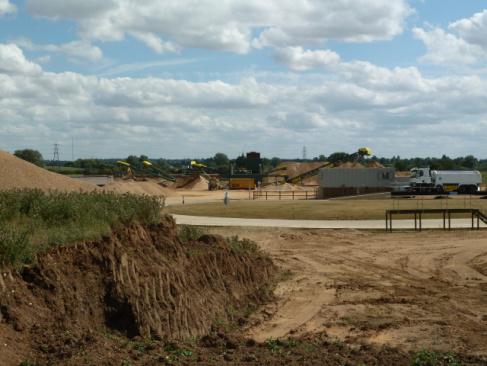
11 2.0 THE PROPOSED DEVELOPMENT 2.1 Black Cat Quarry: Current Circumstances The currently approved quarry development scheme involves the extraction of sand and gravel via a nine phase development scheme, in a generally clockwise direction within a site bounded by the River Ouse to the east and the A1 to the west. The extension area seeks to secure the extraction of some 150,000 tonnes to the south of the current Quarry and 500,000 to the north. Figure 2-1 illustrates the general arrangement of the existing quarry and the extension areas. The proposed development seeks to continue the principles of the permitted scheme in terms of the methodology of extraction and the operational controls imposed on the Quarry. The existing Quarry has progressed into extraction of Phases 6 and 7 during early 2015, with Phases 1 and 3 now comprising the plant site and stock areas; Phase 2 the silt lagoon area. Phases 8 and 9 are currently undisturbed awaiting future development. The current restoration scheme is based upon re-creating agricultural land in the western part of the site to reinstate some 13 hectares of best and most versatile agricultural land, largely above the flood plain and to preexcavation ground levels. The eastern area of the site will be restored as a lake, with a series of islands, sandbanks, reed beds, flood plain pasture and wet woodland which will create a wide range of wildlife habitats. This element of the restoration work will be achieved using indigenous overburden and by over deepening the lake area to provide additional restoration material. The proposed extension development extraction and restoration proposals are illustrated on Figures 2-2 and The scheme represents a progression of the phased development of the existing quarry into the extension areas, and where the restoration scheme for the extension areas builds upon the same restoration principles and land uses as will be implemented at the existing quarry. The proposed phasing scheme for the extension areas is based upon the boundaries of the preferred area application in the MWLP (reference MWLP Inset Map 5). Consistent with the current scheme, the extension development will adopt the same working margins of: Residential properties: 100m Bank of River Ouse: 30m A1: 15m Rockham Ditch: 7m South Brook (in northern extension area): 7m The current scheme includes a standoff margin of 100m to the residential property Green Acres which is situated on the west side of the site, and 100m to a first floor flat above an industrial premises at Keen Screen Services off the Black Cat roundabout. 2.2 Proposed Development The proposed development will continue to use the existing facilities at the Black Cat plant site for the duration of the extension period. The current processing plant, weighbridge and office accommodation will all be retained, and the existing road access onto the Black Cat roundabout will continue to be the only public highway access/egress. Figure 2-1 shows the general layout of the application site, identifying the mineral extraction area, plant site, soil storage area, and ancillary facilities. The development of the extraction areas can therefore be described in three distinct phases, to be commenced during the extraction of minerals from Phase 9: (i) The preliminary works associated with gaining access from Phase 9 to Phase 10 will be followed by soil and overburden stripping and placement followed by the initial extraction phase; (ii) development will then be transferred to the northern area, with the construction of the haul road from Phase 1 to Phase 11, and the progression of soil stripping, placement, extraction and restoration through Phases 11 to 14; Black Cat Quarry P a g e 5 SLR Consulting Limited
12 (iii) The final restoration of the site and associated aftercare. Figure 2.3 illustrates the phasing throughout the working period of the site, and the manner of progressive restoration which focuses on the eastern part of the existing site, followed by the southern areas, the northern fields, and is completed by the current plant site etc. within the central area adjacent to the A1 and the Black Cat Roundabout. The following summarises the development of each of the Phases within the extension areas and the final works associated with the restoration of the site Phase 10 Phase 10 represents the southernmost extent of the extraction scheme. During the latter stages of the extraction from phase 9, a bridge will be constructed over Rockham Ditch to create an access route into the working area of Phase 10. Phase 10 has been designed to be completed within 6 months of commencement: the topsoil and overburden will be transported the short distances to the stockpile locations within Phase 9. It is assumed that the gas pipeline that crosses this phase will be diverted/removed in advance of the development of the phase commencing. The extraction of approximately 150,000 tonnes of sand and gravel from an area of 2.6 ha. will then take place in a west to east direction with all material transported via the bridge, through Phases 9 and 4 to the processing plant Phase 11 During the latter stage of Phase 10 operations, preparation works will commence which will open up the northern extension area. A breach some 10m wide will be created in the topsoil bund that is in place along the northern boundary of Phase 1, to facilitate the crossing of the ditch, and gain access to the northern extension area. The stripping of topsoils from a net area of 4.7ha. will commence in order to establish screening bunds along the western and northern boundaries, which will define the extent of extraction. In addition a bund will be created on the north-west corner of Phase 12. The quantity of overburden within Phase 11 and the requirement to retain the material within the phase boundary is such that the stripping of overburden and the extraction of sand and gravel (110,000 tonnes) will be undertaken in sub-phases, with stripping and extraction occurring almost contemporaneously in a west to east direction. Limited short-term storage of overburden will be required within Phase 11. During the operations in Phase 11, the restoration in Phase 10 and then Phase 9 will be undertaken. Phase 10 will be restored in accordance with the lake, reed beds, and wet grassland as shown on Drawing BC06. The restoration of Phase 9 will also commence with the placement of topsoils from Phase 4, followed by the removal of the bund along the eastern perimeter of Green Acres. Phase 9 will be restored entirely to agricultural use Phase 12 Operations will move into Phase 12 (net area 4.5 ha.), the eastern boundary of which is defined by the current route of the oil pipeline. Topsoils and overburden will be used to restore Phase 11, thus removing the need to create stockpiles of material for later restoration, avoiding the need for double handling of material, and ensuring that restoration of Phase 11 to agricultural use is undertaken swiftly and efficiently. This will be assisted by the use of topsoils and overburden from the perimeter screen bunds within Phase 11. Extraction of approximately 92,000 tonnes will take place in an easterly direction, with material transported southwards to the plant site Phase 13 The extraction operations will continue into Phase 13 with stripped topsoils and overburden again used to immediately restore Phase 12 to Black Cat Quarry P a g e 6 SLR Consulting Limited
13 agriculture. A haul route will be created along the northern bank of the southern ditch, defined by a 2m high overburden bund. Some 150,000 tonnes of sand and gravel will be extracted from the 6.8ha. within Phase 13. The intention is to avoid the storage of significant quantities of soils within Phase 13 by directly restoring Phase 12, although residual overburden and topsoil may be stored within this phase, pending its restoration Phase 14 The development of Phase 14 (8.9 ha.) will commence with the construction of a crossing of South Brook which runs along the northern boundary of Phase 13, with a haul route following the boundary of Phase 12 restoration. Some 154,000 tonnes of sand and gravel will be extracted from Phase 14 in a clockwise direction, with approximately one third of the total topsoil and overburden used to restore Phase 13 to lake and wet grassland, with the remaining material stored around the perimeter of the phase Final Working Phases The final elements of the scheme will include material from Phase 14 used to profile the margins of a lake and to create wet grassland, with the remainder used to restore the haul routes, and complete Phase 13. All remaining topsoils and overburden from the northern extension will be used to complete all elements of restoration. The focus will then turn to the extraction and restoration of the final elements of the site, including the extraction of approximately 100,000 tonnes of sand and gravel from beneath the current stockpile area (in Phase 4), the processing plant area (Phase 3), and finally the site facilities and car park (Phase 1). The dedicated access from the Black Cat roundabout will be retained. 2.3 Processing Plant The plant comprises a conventional washing and screening plant which produces the required sand and gravel products. No changes to the existing arrangements or output volumes are proposed as part of the current application. 2.4 Hours of Operation The current hours of working as prescribed in the 2015 planning permission are: Monday Friday, and on Saturday No operations take place on Sundays, Bank or Public holidays. No changes to these operational hours and working practices are proposed as part of the current application. 2.5 Output and Traffic Movements The proposed output from the Quarry is forecast to be up to an average of 350,000 tonnes per annum. Based upon the above working hours, a 275 day working year, and average load sizes of 20 tonnes, this equates to an average of 63 loads per day (126 movements). This proposed traffic flow is in accordance with the current planning condition that restricts the site to no more than 200 HGV movements (into or out of the site) in any one day (or part of), and no more than 20 HGV movements per hour between the peak hours of 07:00 and 09:00. It is proposed that these terms are replicated in order to ensure that any shortterm increase in production can continue to be supplied. Black Cat Quarry P a g e 7 SLR Consulting Limited
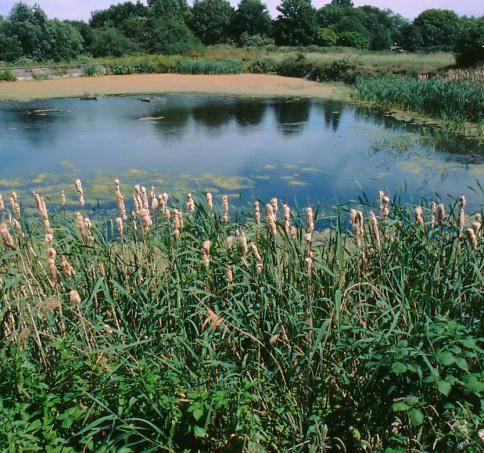
14 All traffic to and from the quarry uses the dedicated access route from the Black Cat roundabout, which was improved as part of a Highways England scheme in 2014/2015. This gives all vehicles unrestricted access via the A1 and A421 to local markets in all directions. It is proposed that this arrangement will continue for the duration of the operations, and that there are no capacity issues on the Black Cat interchange. 2.6 Restoration Strategy The proposed Restoration Strategy is shown on Figure 2-4 and acts as a logical progression from the currently permitted final restoration scheme. The existing scheme involves the re-establishment of agricultural land in the western area of the site, above the floodplain, and the creation of a series of lakes and wetland habitats in the eastern area designed to enhance the landscape and nature conservation value of the restored site. The Restoration Strategy accompanying the extension application adopts the same land use principles as those included within the currently approved scheme, and will extend the acknowledged landscape and nature conservation benefits along the river corridor. The reintroduction of natural features such as woodland and hedgerow planting will mitigate for the loss of landscape features in the medium to long term and will ultimately add landscape / conservation value to the site. This is consistent with the other restored workings present within the local area (such as Begwary Brook), of which most are recognised as important wildlife sites. Overall the scheme aims to make best use of the materials available on site in order to improve the long term visual appearance of the site, draw strong links to the wider landscape character, and be beneficial in terms of ecology including the provision of habitat resource. The key planting types include the establishment of willow carr, woodland and hedgerows with trees; the pond margins will include reedbed and shingle bars, with the surrounding areas being developed as wet grassland. The western area of the site will be restored to arable agricultural use. These areas will be divided by hedgerow planting with an unexploited strip or conservation headland being retained to protect the hedgerows and improve biodiversity. The site will be progressively restored with levels within the western part of the site being bought up to tie into adjacent areas, ultimately to be returned to agricultural after uses. This agricultural restoration will include Phase 11 and the majority of 12 which will act as a continuation of restored agricultural land within Phases 1, 3, 4 and 9. The eastern part of the restored site will continue the land use strategy of the approved scheme for the existing quarry, incorporating a series of ponds and wetland areas. This includes restoration of Phase 10 to the south of the site which, immediately following extraction, will be restored to a pond surrounded by wet grassland. Phases 13 and 14 to the north bear a close relationship to the river and Begwary Brook Nature Reserve and will thus also be restored to ponds / wetland, continuing the theme set by Phases 2, 5, 6, 7, and 8 of the current permission. Black Cat Quarry P a g e 8 SLR Consulting Limited

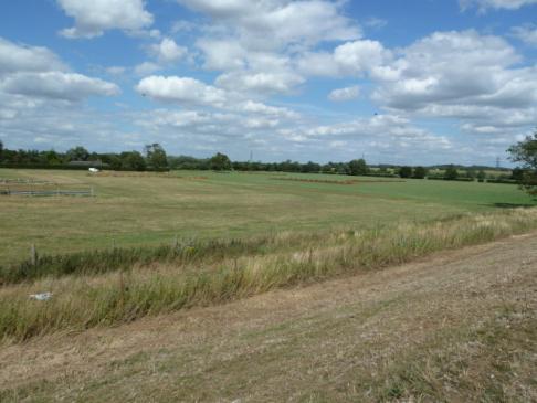
15 Figure 2-1 Current Situation Black Cat Quarry P a g e 9 SLR Consulting Limited

16 Figure 2-2 Quarry Phasing Scheme Black Cat Quarry P a g e 10 SLR Consulting Limited
17 Black Cat Quarry P a g e 11 SLR Consulting Limited
18 Black Cat Quarry P a g e 12 SLR Consulting Limited

19 Figure 2-3 Restoration Strategy Black Cat Quarry P a g e 13 SLR Consulting Limited
20 Black Cat Quarry P a g e 14 SLR Consulting Limited
21 3.0 SUMMARY OF ENVIRONMENTAL ISSUES 3.1 Introduction The main Environmental Statement (ES) has considered the potential environmental effects of the proposed extension to Black Cat Quarry. Based upon the studies and content of the individual chapters, the underlying conclusion of the ES is that there is no single topic, or combination of issues which will objectively prevent the development from proceeding. This in part reflects the fact that the extension areas are allocated in the adopted MWLP as preferred areas for future sand and gravel extraction, with the acknowledged general environmental suitability of the sites for the proposed development (as discussed in more detail in the Planning Application Statement). The respective environmental studies have assessed the effects of the proposed development and where relevant, the studies have made a series of recommendations for measures which could minimise effects, and/ or result in positive enhancements. These issues are set out below as a summary of the technical studies reported in the ES. For each topic, the summary describes the key elements of the study which has been undertaken, the mitigation measures which have been incorporated into the design of the working and restoration scheme or which will be implemented as part of the development, and the conclusions which are reached regarding environmental effects. 3.2 Landscape and Visual Effects LVIA Study The landscape and visual impact assessment has been carried out with particular regard to the Guidance for Landscape and Visual Assessment- 3rd Edition, produced by the Landscape Institute and Institute of Environmental Management and Assessment A study of the landscape and visual components of the site and the development was undertaken through desktop study and fieldwork. This study identified the main receptors and created a baseline visual appraisal against which the existing and proposed landscape and visual impacts were assessed. The main landscape and visual implications of the development and their potential impacts were identified and mitigation described to further reduce these impacts Landscape Impact The proposed mineral extraction will result in a direct physical change to the landscape, most notably in the short to medium term while quarrying takes place. Alongside these physical changes increased activity will be present, this being associated with the movement of plant / vehicles within the site and on the adjoining road network. The effects associated with the quarrying activity will be present for approximately 3 years, and towards the end of this process the progressive restoration of the application site will commence. At this point the natural characteristics of the site will begin to return, ultimately resulting in the site being restored to a combination agricultural after use and wetland habitat in the medium to long term i.e. once the landscape treatments have established. This is likely to be seen as beneficial in terms of adding value and interest to the landscape The combination of inherent mitigation provided by vegetation, infrastructure and other built development along with screening Black Cat Quarry P a g e 15 SLR Consulting Limited
22 measures within the site itself will help to reduce any perceived landscape effects on the adjacent / wider landscape Visual Impact The 3 year duration of the proposed quarry extension means that visual effects relating to extraction activity will be short / medium term, with the establishment of restoration works occurring in the medium / long term i.e. allowing time for seeding, hedgerows and tree belts to establish. The viewpoint analyses describes what will be the worst case scenario for the identified views, as the viewpoints represent what are likely to be the least interrupted views of the proposed development. Surrounding tree belts combined with the additional screening provided by screen bunds means that views are generally glimpsed through gaps in this vegetation. Overall the visual impact study concludes that the proposed development will not give rise to a significant visual effect Landscape Mitigation measures Landscape mitigation measures have been included within the development proposals including the phased programme of working and restoration, the direction of working, and the creation of screen bunds. The presence of an existing processing plant and associated features is such that there will be little change in the overall landscape. The size and extent of the extraction area will be restricted by the phased working and restoration scheme. In addition, the nature of the soil stripping and extraction will minimise the visibility of any disturbance. The key mitigation measure is the restoration scheme itself which seeks to enhance the landscape and ecological value of the site. Overall the scheme aims to make best use of the materials available on site in order to improve the long term visual appearance of the site, draw strong links to the wider landscape character and be beneficial in terms of ecology including the provision of habitat resource. Areas to the west of the site will be restored to arable agricultural use, with the eastern areas restored as a series of ponds and wetland which will support a wide range of habitat types Landscape and Visual Conclusions Any potential impacts as a result of the proposed development will be minimised as a result of the design of the working scheme, the short duration of the development, and the beneficial effects of the restoration scheme. 3.3 Ecology Ecology Study There are no statutory designations within or adjacent to the proposed development site. The River Great Ouse County Wildlife Site lies along the eastern boundary of both the north and south extensions, and the the Begwary Brook Pits County Wildlife Site lies adjacent to the northeast of the northern extension. Surveys have been undertaken to assess the presence of potential features and species of interest within the site. Potential impacts have then been assessed with regard to direct and indirect effects. Potential direct effects on habitats and species include habitat loss (both permanent and temporary); habitat degradation (for example, due to deposition of dust, or changes in hydrology); disturbance to and displacement of species (for example, through increased human presence, noise and artificial lighting); and injury/mortality. Potential indirect impacts comprise exclusion from habitat (for example, by physical barriers); dispersal from and abandonment of a specific site or area of habitat; habitat fragmentation (for example, by severance of favoured commuting/migration routes); altered behavioural patterns (for example, increased foraging by some species of bats around lighting, Black Cat Quarry P a g e 16 SLR Consulting Limited
23 but avoidance by others); and injury/mortality (for example, due to increased predation risk following habitat fragmentation) Ecology Impacts The site has been assessed as having a low ecological value. The only receptor that has specific value is the hedgerows and associated trees that will be removed as part of the extraction works. Full ecological surveys including surveys for protected species have identified that none will suffer a significant adverse impact during the life of the quarry. A length of 325m of hedgerow including six mature trees, across the northern extension area, will need to be removed to facilitate mineral extraction. The central corridor alongside South Brook will be retained except for the widening of the existing bridge crossing the brook. Rockham Ditch that flows along the northern edge of the southern extension area along with adjacent hedgerow will be retained except for the creation of a new bridge crossing for the haul road into the southern extensions area. There will be no indirect impact on other habitats as sufficient stand-off zones between the workings and adjacent habitats like the River Great Ouse, South Brook, Rockham Ditch, hedges and trees will be sufficient to ensure no indirect impact. Extensive surveys have identified no protected species present on the site. During the development works, there will be a low level of impact due to the loss of the central hedgerow across the northern extension area. Surveys showed a low level of bat foraging along this hedgerow although the absence of bat roosts. A low level of bird activity was observed and therefore loss of the hedgerow will have a low negative impact due to loss of potential bat foraging habitat and nesting sites Ecology Mitigation measures The 325m of hedgerow that will be lost during mineral extraction in the northern extension will be replaced by 750m of new hedgerow planting in the restoration scheme. A minimum of ten standard trees will be planted in the hedgerows to replace those lost. No hedgerow will be lost in the southern extension area but an additional 150m of new hedgerow with three standard trees will be created in the restoration of the southern extension area. In addition, extensive new areas of habitat will be created on the eastern side of both the northern and southern extension areas with water bodies encompassing reed beds, shingle bars surrounded by large areas of wet grassland. These will greatly enhance the biodiversity of the site and provide new habitats to the site by creating a string of water bodies along the River Great Ouse corridor starting from the Begwary Brook Pits County Wildlife Site in the north Removal of existing hedgerows and trees will be carried out between October and February to avoid the nesting bird season. Any vegetation clearance outside that time will be preceded by a nesting bird survey by a suitably experienced ecologist. The new hedgerow and tree planting will provide additional opportunities for foraging bats and for nesting birds. The extensive areas of water bodies, reed beds and wet grassland will provide habitats for a wider variety of species than occupy the site before mineral extraction commences Ecology Conclusions The restoration scheme presents a significant opportunity to enhance and improve the ecological value of what are currently low ecological value areas of grassland. 3.4 Surface and Groundwater Surface and Groundwater Study A detailed study has ensured that surface water and groundwater conditions at the site are fully understood and thus able to inform the Black Cat Quarry P a g e 17 SLR Consulting Limited
24 assessment of the potential impacts posed by the proposed development upon the water environment. Approximately 60% of the site area lies within Flood Risk Zone 3 which means that there is a risk of flooding occurring one or more times every hundred years. The assessment considers how the working of the site in the manner currently permitted has the potential to impact upon the water environment in terms of: Where potential impacts have been identified, outline mitigation measures, additional monitoring and data assessment are recommended, including: i. the existing regime of monthly groundwater monitoring will be continued for the life-span of the proposed development and into the aftercare period. ii. Cut-of drains will be installed as part of the restoration of the site; i. Potential for impact upon groundwater levels and flow. ii. iii. iv. Potential for direct derogation of surface water flows and waterbodies. Potential for direct derogation of groundwater quality. Potential for direct derogation of surface water quality. v. Potential for the quarry to increase the existing flood risk Mitigation Measures: The mitigation measures in respect of the water environment, and the Flood Risk Assessment specifically focus on design elements. iii. vi. vii. viii. ix. Routine sampling of off-site discharge and analysis for suspended solids content; Formulation of a flood emergency plan; to ensure routes of access / egress are clear at all times; Bunds will not impede the flow of flood waters, by use of breaks / offsets / orientation / adequate under drainage as appropriate. Quarry faces abutting local surface water features will be clay battered during mineral extraction to minimise groundwater ingress (as currently undertaken); Surface water level monitoring will be established in the South Brook and Rockham Ditch; The site will establish a flood emergency plan, to be adopted within the quarry emergency procedure. This will include measures for the evacuation of all vulnerable areas in the event of flooding, with routes of access / egress being kept clear at all times. No additional mitigation measures are considered necessary with regards to the prevention of impact on flood risk posed to / by the proposed development Surface and Groundwater Conclusions In view of the findings of the assessment and the planned approach to the proposed development, which includes specific measures for the protection of the water environment, there are considered to be no over-riding surface or groundwater reasons why the planned development could not proceed. Black Cat Quarry P a g e 18 SLR Consulting Limited
25 3.5 Noise Noise Study The methodology for the noise study follows the advice and approach to suggesting site noise limits as set out in the Planning Practice Guidance (PPG) to the National Planning Policy Framework (NPPF). The assessment considers the likely noise levels that would be generated by the proposed development at the nearby noise-sensitive receptors. An assessment has been made of the baseline situation and the potential impact of the proposals and, where appropriate, mitigation measures have been identified to offset potentially adverse environmental impacts. Operational noise levels generated by the mobile plant associated with operations at the site have been predicted and have been assessed against the guidance contained in the PPG. The predicted noise emissions have been compared against the existing average background noise around the application site measured at four representative properties, and the noise limits at these properties have been calculated based on the guidelines in the PPG. The noise limits are based upon the advise in PPG that, under normal circumstances, noise from the site should not exceed the existing background (LA90) noise level by more than 10dB, and should in any event not exceed a maximum of 55dB LAeq,1hr. The development includes an in built design mitigation measures in the form of screen bunds and stand-offs from noise sensitive properties. the predicted noise levels for normal operations will be below the proposed noise limits at all locations assessed. The construction of infrastructure associated with the development (internal haul routes etc.) and soil stripping will be confined to periods of no more than eight weeks in any year where the noise levels will be considerably below the noise levels allowable for temporary operations (70dB LAeq,1hr for up to eight weeks per year) Noise Conclusions With the implementation of the recommended mitigation measures, and the attenuation provided by working at the base of the sand and gravel deposit to extract the mineral, the assessment has found that: noise levels generated by infrastructure development and soil stripping would meet the proposed noise limits based upon advice in PPG at all assessed locations; noise levels generated by infrastructure development and soil stripping would be within the maximum noise limit (55dB LAeq,1hr) allowable for normal operations; and noise levels associated with temporary operations would below that allowable for temporary operations (70dB LAeq,1hr for up to eight weeks per year). Based on the operational activities described, the strategic location of storage and screening mounds, and the application of mitigation measures, it is considered that the applicant has taken all practical steps to ensure that the proposed development meets the proposed noise limits derived in accordance with current PPG and the NPPF Noise Mitigation Measures The predicted noise levels do not take into account the attenuation that may be provided by the quarry face as extraction takes place below ground level. With the inclusion of this additional mitigation measure, Black Cat Quarry P a g e 19 SLR Consulting Limited
26 3.6 Air Quality Air Quality Study The assessment has considered the potential impacts on air quality with reference to the relevant legislation, baseline conditions, activities associated with the site including haulage, excavation activities, storage of material, and restoration of the site. An assessment of deposited dust identified the potential sources of dust on site. Receptors were ranked in terms of the risk of dust impact which is dependent on the distance from the site boundary, the frequency of wind direction and rainfall patterns. The implementation of dust control measures as part of routine good management are considered to offer effective safeguards, and therefore impacts are considered to be insignificant. The potential for dust impacts on the surrounding ecological sites has been assessed as insignificant Air Quality Mitigation Measures Mitigation measures for the stripping of soils / overburden, the storage and the subsequent restoration activities focuses on effective site management. Given the proximity of the water table to the surface of the application site, the mineral is likely to be extracted with a high moisture content and therefore of minimal requirement for additional water during extraction and immediate transfer. In the unlikely event that mineral is allowed to dry out during these activities, control of dust will be aided through the use of water suppressants as and when required such as during dry and windy weather conditions Dust emissions during the transfer of material will be minimised by ensuring drop heights are minimised wherever practicable and vehicles are not overfilled for transfer to the processing plant. The storage of mineral is the only dust source that will be an on-going operation throughout the circa 3 year duration of the development. Stockpile surfaces will be profiled and sprayed regularly and to prevent the dispersion of material, areas around the base of stockpiles will be clearly designated to ensure passing vehicles do not disturb dusty material. Haulage on temporary, compacted haul roads has been identified as one of the activities with the highest potential for dust emissions in the absence of mitigation. The primary control measure that will be employed on site is the surface treatment of the haul roads through the use of watering by a tractor and bowser. Maintenance of haul roads by grading also minimises dust emissions due to less erosion of the haul road by passing vehicles. Vehicle speed restrictions will also be implemented and enforced Air Quality Conclusions In summary, the risk of dust impact at the receptor locations surrounding the quarry is considered to be reduced to an insignificant or acceptable level following the application of the mitigation measures described. 3.7 Traffic Traffic Study In the context of transport and highways issues, the key features of the development are as follows: The extraction of the remaining reserves at the existing quarry, up to the summer of 2016, based upon the current planning permission; The extraction and distribution of an additional 650,000 tonnes of sand and gravel from the extension areas, over a period of up to 3 years; Black Cat Quarry P a g e 20 SLR Consulting Limited
27 The predicted output from the site is anticipated to remain at recent levels of up to 350,000 tonnes per annum, generating some 65 loads per day (130 movements); No changes are proposed to the current access arrangements or pattern of vehicle movements; and The operating hours will remain unchanged from those set out in the current planning permission. In effect, in terms of transport and highway matters, the proposed development will result in no change to the current situation, beyond the fact that the existing traffic movements to/from the site will continue for an additional period, and some 3 years overall Traffic Mitigation Measures The recent improvements to the Black Cat Roundabout arrangement are such that no mitigation measures are proposed Traffic Conclusions The development proposals will create a temporary and negligible traffic impact on the surrounding road network. Aggregate will continue to use existing arrangements. 3.8 Cultural Heritage Cultural Heritage Study There have been considerable archaeological investigations undertaken within the existing Black Cat Quarry. An initial Desk Based Assessment (DBA) considered the archaeological and historical background of the original quarry area (Phases1-9) together with a wider 1km study area, which included the northern and southern extension areas. This DBA identified that the proposed quarry had high potential for the existence of significant archaeology from the Iron Age and Romano- British periods, with a lower probability of evidence for small-scale early prehistoric and Saxon activity. It also concluded that archaeological remains of a lesser significance such as medieval ridge and furrow could survive, and that the palaeochannels (former river courses) thought to be present on the site have the potential to preserve evidence for past environments. The DBA highlighted the presence of cropmarks of probable Iron Age or Romano-British date including an enclosure within the quarry area as well as a smaller enclosure immediately to the south, in what is now the proposed Phase 10 extraction area. A subsequent phase of evaluation trenching was undertaken in 2005, along with geophysical survey in 2006 and further evaluation in 2007 which assessed the archaeological potential of the original quarry area and its surrounding environs ARS Ltd carried out a strip, map and sample evaluation within the original quarry boundary throughout 2014 and 2015 within phases 1-9 (with the exception of Phases 5, 8 and 9, which have not yet started). The archaeological evidence uncovered during this evaluation also contained features and material culture dating from the Prehistoric to the modern period. ARS Ltd has also carried out a phased programme of archaeological evaluation as part of this application for the north and south extension areas including geophysical survey, evaluation trenching (and aerial photographic mapping, in addition to a desk-based study. Evaluation trenching within the proposed southern (Phase 10) and northern (Phase 11-14) extension areas was undertaken in July and early August Five trenches were excavated within Phase 10, which comprises a triangular field to the south of the main quarry on the southern side of the watercourse known as the Rockham Ditch. A further 28 trenches were excavated across Phases 11 to 14 in three fields to the north of the main quarry in the northern extension zone. Black Cat Quarry P a g e 21 SLR Consulting Limited
28 Phase 10 contained archaeological features that are likely to be associated with prehistoric or Roman period land division on the higher gravel terrace found immediately to the west of the River Great Ouse in this area. In the northern extension area archaeological features of a very similar nature to those in the southern area were identified, with features appearing on the higher gravel terraces of Phases 11 and 12. All of the trenches in Phase 13 and those in the eastern half of Phase 14 were located on the lowest lying areas of the floodplain and contained no archaeological features Mitigation measures Consistent with the approach in the existing quarry, a strip, map and sample methodology will be deployed for the extension Phases with archaeological supervision of the stripping of topsoil and subsoil layers undertaken in a flexible way so that it is intermittent over areas of low archaeological intensity and continuous over those areas of high intensity. The stripping will be undertaken by experienced machine operatives. This will allow for the soil of an area to be removed, the surface of the subsoil inspected for archaeological remains, followed by their targeted mapping and sampling. Once this is complete then the subsoil can be removed down to the next layer where archaeological remains can again be mapped and sampled. submitted to the Bedford Borough Council s Historic Environment Team for approval prior to the works taking place. After completion the programme of mitigation will include provision for reporting, archiving and widespread dissemination of the results in an appropriate academic format and format for the wider public (e.g. webbased information) Cultural Heritage Conclusions The assessment has identified that both the northern and southern extension areas are likely to contain archaeological remains of a similar nature to those already recorded in the Phase 1-9 areas where a large rectilinear enclosure and appended field systems dating to the Romano-British period was recorded, as well as isolated prehistoric pits. Similar, though smaller, rectilinear enclosures have been identified as cropmarks in both of the extension areas, though it is likely that the southern example will have been truncated by the pipeline that is known to cross this area. It is concluded that the fieldwork methodologies undertaken during previous phases of extraction, comprising strip, map and sample ahead of each phase of extraction will be appropriate mitigation for the proposed quarry extension areas, and a WSI providing a detailed methodology for these works will be submitted to Bedford Borough Council s Historic Environment Team for approval prior to topsoil stripping commencing. This flexible approach means that the archaeological response can be scaled up or down according to the volume of archaeological remains present. This approach is in line with those advocated in Mineral Extraction and Archaeology: A Practice Guide (MHEF 2008) which sets out national best practice and endorsed by both the minerals industry, archaeology sector and planning sector. Full details of the fieldwork and post-excavation methodologies will be provided in a Written Scheme of Investigation (WSI) which will be Black Cat Quarry P a g e 22 SLR Consulting Limited
NON-TECHNICAL SUMMARY
 Proposed Sand and Gravel Extraction and Associated Processing Operations with Restoration to a Mixture of Agriculture and Nature Conservation including Areas of Shallow Water at Hedgeley, Northumberland
PANSHANGER QUARRY, Hertfordshire
 PANSHANGER QUARRY, Hertfordshire Proposed enhanced restoration of Phases F & H Briefing Note 1 March 2015 INERT (INACTIVE) RESTORATION MATERIALS, CONTROLS AND OPERATIONS 1 Introduction This briefing note
Rempstone Extension - East Leake 2014
 Overall Restoration of East Leake Quarry Sand Martin Face Southern Agricultural Corridor Wetland Ponds/Conservation Corridor following Sheepwash Brook Reinstated Bridleway/Footpaths Southern Agricultural
BREEDON NORTHERN LIMITED
 Non Technical Summary CONTENTS 1 INTRODUCTION... 1 2 SITE DESCRIPTION... 1 3 DESCRIPTION OF THE DEVELOPMENT... 6 4 NEED FOR THE DEVELOPMENT... 8 5 KEY ISSUES CONSIDERED IN THE ENVIRONMENTAL IMPACT ASSESSMENT...
Town and Country Planning (Environmental Impact Assessment Regulations) 2011 SCOPING OPINION
 2011 SCOPING OPINION") Town and Country Planning (Environmental Impact Assessment Regulations) 2011 SCOPING OPINION Application Site and Description of Development Proposed new quarry at Culham, Oxfordshire Land and Mineral
Town and Country Planning (Environmental Impact Assessment Regulations) 2011 SCOPING OPINION Application Site and Description of Development Proposed new quarry at Culham, Oxfordshire Land and Mineral
Wyvern Park Skipton Environmental Statement. Non-technical Summary - April 2015
 Wyvern Park Skipton Environmental Statement Non-technical Summary - April 2015 BWB Consulting Ltd Whitehall Waterfront 2 Riverside Way Leeds LS1 4EH Telephone: +44(0)113 233 8000 Copyright This Report
University Park, Worcester Non Technical Summary December 2011
 University Park, Worcester Non Technical Summary December 2011 Introduction UW Wrenbridge LLP, a Joint Venture Company of the University of Worcester and Wrenbridge Land Ltd (the Applicants ) intend to
Replacement Golf Course Facilities and Residential Development, Churston. Environmental Statement Non-Technical Summary
 Replacement Golf Course Facilities and Residential Development, Churston Environmental Statement Non-Technical Summary July 2011 Reproduced from the Ordnance Survey s map with the permission of the Controller
SPG 1. * the northern and western sections which are open fields used for pasture and grazing;
 SPG 1 1.0 INTRODUCTION This development brief is based on the allocation of the Priors Hall site for employment and countryside recreational purposes in the Corby Borough Local Plan. The brief is intended
LAND AT WEST YELLAND. Environmental Statement Non-Technical Summary Welbeck Strategic Land LLP
 LAND AT WEST YELLAND Environmental Statement Non-Technical Summary Welbeck Strategic Land LLP May 2014 Quality Management Issue/revision Issue 1 Revision 1 Revision 2 Revision 3 Remarks Draft FINAL Date
Request for a Scoping Opinion by Provectus. Proposed Surface Mining of Coal on Land west off the A61, Hill Top Farm, Clay Cross, Derbyshire
 Request for a Scoping Opinion by Provectus Proposed Surface Mining of Coal on Land west off the A61, Hill Top Farm, Clay Cross, Derbyshire January 2012 Contents 1 Introduction & Background... 1 2 Site
Kier Infrastructure and Overseas Limited Greenburn Surface Mine, Dalgig Farm Site
 Kier Infrastructure and Overseas Limited Greenburn Surface Mine, Dalgig Farm Site Planning application pursuant to s.42 Town and Country Planning (Scotland) Act 1997 to amend the restoration scheme Volume
Barvills Solar Farm Environmental Statement Non-Technical Summary
 Barvills Solar Farm Environmental Statement Non-Technical Summary 13 March 2015 Produced for Prepared by St John s House Queen Street, Manchester M2 5JB Contents Contents... 2 1 Introduction... 3 1.1 Development
Departure from the Development Plan. Town Council objection to a major application. DETERMINE
 Item No. 9 APPLICATION NUMBER CB/17/01642/OUT LOCATION Land rear of 43 to 91 Silver Birch Avenue South of Alder Green and Aspen Gardens, Aspen Gardens, Stotfold PROPOSAL Outline application for up to 95
Grantham Southern Quadrant Link Road Environmental Statement
 Grantham Southern Quadrant Link Road Environmental Statement Non Technical Summary Introduction Lincolnshire County Council (LCC) is submitting a planning application for the proposed implementation of
Inert Recycling (UK) Ltd Boxgrove Quarry Restoration Environmental Statement
 Ltd Boxgrove Quarry Restoration Environmental Statement") November 2013 Non-Technical Summary Empress House, 12 Empress Road, Lyndhurst, SO43 7AE Tel: 023 8028 3226 Email: waste.enquiries@wyg.com Introduction Background EIA is a process by which the environmental
November 2013 Non-Technical Summary Empress House, 12 Empress Road, Lyndhurst, SO43 7AE Tel: 023 8028 3226 Email: waste.enquiries@wyg.com Introduction Background EIA is a process by which the environmental
Ʊ ± ªº Œª ºª ø ª ª ± ª
 Ʊ ± ªº Œª ºª ø ª ª ± ª ø º Õ± ± ± Œ±øºÙ Õ ß Æª ø檺 ±Æ ƪ ø檺 æß Æ± Ʊ ª ø ø fl ª ª ± ê ø Õ øæß ª ª æªæ Ó ÔÌ Non-Technical Summary Introduction A planning application has been submitted to the Vale
Interim Advice Note 76 / 06 ASSESSMENT PART 1 AIMS AND OBJECTIVES OF ENVIRONMENTAL ASSESSMENT. Contents
 Interim Advice Note 76 / 06 VOLUME 11 SECTION 1: ENVIRONMENTAL ASSESSMENT INTRODUCTION PART 1 AIMS AND OBJECTIVES OF ENVIRONMENTAL ASSESSMENT Contents 1. Introduction and Application 2. Aims and Objectives
ROCHFORD LOCAL DEVELOPMENT FRAMEWORK: Sustainability Appraisal/ Strategic Environmental Assessment. Rochford Core Strategy Preferred Options Document
 ROCHFORD LOCAL DEVELOPMENT FRAMEWORK: Sustainability Appraisal/ Strategic Environmental Assessment Non Technical Summary Rochford Core Strategy Preferred Options Document October 2008 SUSTAINABILITY APPRAISAL
DEFGH. Crystal Place Park. Environmental Impact Assessment (EIA) Elin Thomas and Emily Low Waterman Environmental
 Elin Thomas and Emily Low Waterman Environmental") DEFGH Crystal Place Park Environmental Impact Assessment (EIA) Elin Thomas and Emily Low Waterman Environmental 10.12.07 EIA Presentation Content What is EIA? Legal Requirements Process Q&A Key Topics
DEFGH Crystal Place Park Environmental Impact Assessment (EIA) Elin Thomas and Emily Low Waterman Environmental 10.12.07 EIA Presentation Content What is EIA? Legal Requirements Process Q&A Key Topics
The Place Solar Farm
 The Place Solar Farm Environmental Statement Non-Technical Summary 28 August 2014 Produced for Prepared by St John s House Queen Street, Manchester M2 5JB Contents Contents... 2 1 Introduction... 3 1.1
ABBEY MANOR GROUP/SAINSBURY S SUPERMARKETS LTD
 ABBEY MANOR GROUP/SAINSBURY S SUPERMARKETS LTD Mixed Use Development including Business Park and Foodstore Land at Bunford Park, Bunford Lane, Yeovil Environmental Statement: Non-Technical Report June
Archaeological evaluation at Willowdene, Chelmsford Road, Felsted, Essex
 Archaeological evaluation at Willowdene, Chelmsford Road, Felsted, Essex August 2013 report prepared by Ben Holloway on behalf of Mr Anthony McGurren Planning reference: UTT/13/0235 CAT project ref.: 13/07g
RYALL NORTH QUARRY, WORCESTERSHIRE
 RYALL NORTH QUARRY, WORCESTERSHIRE ENVIRONMENTAL STATEMENT NON TECHNICAL SUMMARY VOLUME 3 March 2015 ENVIRONMENTAL STATEMENT NON TECHNICAL SUMMARY VOLUME 3 Proposed sand and gravel quarry Land north of
Greenfield. Greenfield. Proposed River Thames Marina Development: near Wallingford, Oxfordshire
 Proposed River Thames Marina Development: near Wallingford, Oxfordshire Need & Alternatives to the Scheme It is necessary to consider planning policies and any related guidance concerning recreational
LAND AT HOWES LANE, BICESTER ENVIRONMENTAL STATEMENT NON-TECHNICAL SUMMARY. March 2017 Our Ref: Q70433
 LAND AT HOWES LANE, BICESTER ENVIRONMENTAL STATEMENT NON-TECHNICAL SUMMARY March 2017 Our Ref: Q70433 Contents 1 INTRODUCTION AND SITE DESCRIPTION... 1 2 EIA METHODOLOGY... 5 3 ALTERNATIVES... 6 4 DESCRIPTION
LONDON BRIDGE STATION ENVIRONMENTAL STATEMENT NON-TECHNICAL SUMMARY
 LONDON BRIDGE STATION ENVIRONMENTAL STATEMENT NON-TECHNICAL SUMMARY June 2011 1 EXECUTIVE SUMMARY 2 INTRODUCTION CONTENTS Page 2.1 Introduction 4 2.2 The Site 4 3 THE DEVELOPMENT 3.1 What is it? 5 3.2
Land at Copshurst Quarry, Stoke-on-Trent. Environmental Impact Assessment. Environmental Statement, Non-Technical Summary.
 VOLUMEI I I NONTECHNI CALSUMMARY Pl anni ngappl i cat i onf ort hepr oposedext ensi ont ocopshur stquar r y Jul y2015 Land at Copshurst Quarry, Stoke-on-Trent Environmental Impact Assessment Environmental
Chapter 4. Route Window C12: Mile End Park and Eleanor Street Shafts
 Chapter 4 Route Window C12: Mile End Park and Eleanor Street Shafts 48 Crossrail Amendment of Provisions 4 Route Window C12: Mile End Park and Eleanor Street Shafts Location plan of Mile End Park and Eleanor
Newcourt Masterplan. November Exeter Local Development Framework
 Newcourt Masterplan November 2010 Exeter Local Development Framework Background The Exeter Core Strategy Proposed Submission sets out the vision, objectives and strategy for the development of Exeter up
volume 11 environmental assessment section 2 environmental impact assessment Part 7 ha 218/08
 DESIGN MANUAL FOR ROADS AND BRIDGES volume 11 environmental assessment section 2 environmental impact assessment Part 7 ha 218/08 glossary of terms Used in DMRB Volume 11, Sections 1 and 2 SUMMARY This
WELCOME GYPSY LANE. Wider Site Location plan. Proposals for the development of LAND OFF FOXLYDIATE LANE WEBHEATH. Proposals for the development of
 WELCOME The developers are preparing an outline planning application for a residential led development and need the community s views in order to develop the proposals further WHAT IS PROPOSED? A high
Environmental Impact Assessment
 Environmental Impact Assessment Environmental impact assessment (EIA) is the process of systematically drawing together an assessment of the likely significant environmental effects of a development project.
Public Consultation. Land at Monks Farm, North Grove. Welcome
 Welcome Welcome to our public exhibition for development on Land at Monks Farm, orth Grove. Gallagher Estates and Gleeson Strategic Land are preparing an outline planning application for new homes, open
PERSIMMON HOMES (SW) LIMITED LAND AT ADDINGTON, LISKEARD ENVIRONMENTAL STATEMENT NON-TECHNICAL SUMMARY
 LIMITED LAND AT ADDINGTON, LISKEARD ENVIRONMENTAL STATEMENT NON-TECHNICAL SUMMARY") PERSIMMON HOMES (SW) LIMITED LAND AT ADDINGTON, LISKEARD ENVIRONMENTAL STATEMENT NON-TECHNICAL SUMMARY APRIL 2010 INTRODUCTION This document is the Non-Technical Summary (NTS) of an Environmental Statement
PERSIMMON HOMES (SW) LIMITED LAND AT ADDINGTON, LISKEARD ENVIRONMENTAL STATEMENT NON-TECHNICAL SUMMARY APRIL 2010 INTRODUCTION This document is the Non-Technical Summary (NTS) of an Environmental Statement
Cotswolds AONB Landscape Strategy and Guidelines. June 2016
 Cotswolds AONB Landscape Strategy and Guidelines June 2016 Cotswolds AONB Landscape Strategy and Guidelines Introduction The evolution of the landscape of the Cotswolds AONB is a result of the interaction
NON-TECHNICAL SUMMARY
 NON-TECHNICAL SUMMARY THE HIDE, BISHOP AUCKLAND PROPOSED ECO CHALET DEVELOPMENT NON-TECHNICAL SUMMARY 1 Introduction 1.1.1 This non-technical summary for the (ES) prepared in relation to the proposed eco-chalet
volume 11 environmental assessment section 2 environmental impact assessment Part 4 ha 204/08 scoping of environmental impact assessments
 DESIGN MANUAL FOR ROADS AND BRIDGES volume 11 environmental assessment section 2 environmental impact assessment Part 4 ha 204/08 scoping of environmental impact assessments SUMMARY This Advice Note provides
Open Report on behalf of Richard Wills Executive Director, Environment & Economy. Planning and Regulation Committee
 Regulatory and Other Committee Open Report on behalf of Richard Wills Executive Director, Environment & Economy Report to: Planning and Regulation Committee Date: 5 October 2015 Subject: County Matter
ABOUT CALA HOMES CALA HOMES
 WELCOME Welcome to this public consultation event for our proposed development on land to the east of Salisbury Road, in Hungerford. Thank you for taking the time to come along today. Homes and Wates Developments
Kibworth Harcourt. Introduction. Introduction
 Introduction Introduction Welcome to this public exhibition on the proposals for the delivery of new homes on land at The Kibworths. The purpose of today s exhibition is to give you the opportunity to
Longbridge Town Centre Phase 2 Planning Application
 Longbridge Town Centre Phase 2 Planning Application Non-Technical Summary of the Environmental Statement December 2013 Introduction A full application for Planning Permission has been submitted to Birmingham
Haydock Point. Welcome
 Welcome Peel Logistics Property, alongside Peel Land and Property, is preparing a planning application for Haydock Point, a high-quality logistics park east of Haydock. The purpose of this exhibition is
Derry City and Strabane District Council Planning Committee Report. Amended layout from approval A/2004/0462/F with reduction from 166 units
 Derry City and Strabane District Council Planning Committee Report COMMITTEE DATE: 1 st February 2017 APPLICATION No: APPLICATION TYPE: PROPOSAL: LOCATION: APPLICANT: AGENT: Full Planning application Amended
Comments on the proposed scope are requested from WCC/NBBC officers to be provided to SLC Rail by 25 th March 2016 and sent to
 Introduction WCC have indicated that in advance of the surveys and assessments being undertaken consultation should be undertaken with technical officers of both Warwickshire CC and Nuneaton and Bedworth
Great Easton Neighbourhood Plan Statement of Basic Conditions
 Great Easton Neighbourhood Plan 2017-2031 Statement of Basic Conditions OCTOBER 2016 GREAT EASTON PARISH COUNCIL Contents 1.0 Introduction....Page 2 2.0 Summary of Submission Documents and Supporting Evidence..
ES 5. Drakelow Park. Environmental Statement. Volume 5: Non Technical Summary. Lead Author Waterman Energy, Environment and Design Ltd
 Drakelow Park ES 5 Environmental Statement Volume 5: Non Technical Summary Lead Author Waterman Energy, Environment and Design Ltd April 2009 Environmental Statement Volume 5: Non-Technical Summary DRAKELOW
Ivol Buildings, Woodcote Road, South Stoke, Oxfordshire
 Ivol Buildings, Woodcote Road, South Stoke, Oxfordshire An Archaeological Watching Brief For Christ Church, Oxford by Pamela Jenkins Thames Valley Archaeological Services Ltd Site Code IBSS 04/03 March
64 Mineral Extraction Area Rules
 64 Mineral Extraction Area Rules 64.1 Introduction For the purposes of this Chapter: Active Area, in relation to a Mineral Extraction Area (MEA), is that part of the Mineral Extraction Area which is owned
9 CITY OF VAUGHAN OFFICIAL PLAN AMENDMENT NO BOCA EAST INVESTMENTS LIMITED
 9 CITY OF VAUGHAN OFFICIAL PLAN AMENDMENT NO. 631 - BOCA EAST INVESTMENTS LIMITED The Planning and Economic Development Committee recommends the adoption of the recommendations contained in the following
Land at BROOK STREET PROPERTIES TENCREEK FARM, LISKEARD. Environmental Statement: Non-Technical Summary
 BROOK STREET PROPERTIES TENCREEK FARM, LISKEARD Land at Environmental Statement: Non-Technical Summary Introduction Brook Street Properties is applying to Cornwall Council for outline planning permission
Former RAF Sealand Site EIA
 Praxis (Holdings) Ltd. Former RAF Sealand Site EIA Environmental Statement - Non Technical Summary February 2012 in association with P a g e 1 1. Introduction Praxis (Holdings) Ltd. is applying to Flintshire
Planning and Regulatory Committee 23 September Applicant Local Councillor
 Planning and Regulatory Committee 23 September 2014 8. TEMPORARY CHANGE OF USE OF A SECTION OF A FIELD TO A TEMPORARY SITE COMPOUND. THE PROPOSED TEMPORARY SITE COMPOUND MEASURES APPROXIMATELY 4,310 SQUARE
A737/A738 Trunk Road (Dalry Bypass)
") IN ASSOCIATION WITH DRAWING STATUS A737/A738 Trunk Road (Dalry Bypass) Environmental Statement July 2013 Introduction The A737 trunk road forms a strategic link from the M8 motorway, at Paisley, to Ayrshire.
IN ASSOCIATION WITH DRAWING STATUS A737/A738 Trunk Road (Dalry Bypass) Environmental Statement July 2013 Introduction The A737 trunk road forms a strategic link from the M8 motorway, at Paisley, to Ayrshire.
Florida Farm North. Environmental Statement. Non-Technical Summary. July /04/MW/PN
 Florida Farm North Environmental Statement Non-Technical Summary July 2016 41575/04/MW/PN Nathaniel Lichfield & Partners 3rd Floor One St James's Square Manchester M2 6DN 01618376130 www.nlpplanning.com
Archaeological Evaluation and Assessment of Land at Minnis Beeches, Canterbury Road, Swingfield, Dover, Kent
 Archaeological Evaluation and Assessment of Land at Minnis Beeches, Canterbury Road, Swingfield, Dover, Kent NGR: TQ 6307 1545 Site Code: MB-EV-10 (Planning Consent Y10/0311/SH) Report for Thorndene Ltd.
Welcome. Site/11/04. Site/11/03. Proposed Site. 11,400 new homes needed in east Cambs
 Welcome Welcome to our consultation on our proposals for new homes on land north east of Soham Road, Fordham. Members of the project team are available to answer any questions you have and listen to feedback.
Archaeological Evaluation and Assessment of Land at Kent Cottage, 19 Chapel Street, Hythe, Kent
 Archaeological Evaluation and Assessment of Land at Kent Cottage, 19 Chapel Street, Hythe, Kent Planning Application Y13/0463/SH Date of Report: 29/04/2015 Report for Marc Carney SWAT. ARCHAEOLOGY Swale
London Road, Derker. Non Technical Summary. Introduction
 London Road, Derker Non Technical Summary Introduction The Oldham Rochdale Housing Market Pathfinder was set up to tackle longstanding problems of poor quality housing and to provide the framework for
Archaeological evaluation: land to the rear of Clare Road, Braintree, Essex
 Archaeological evaluation: land to the rear of 41-45 Clare Road, Braintree, Essex March 2014 commissioned by Mr Mark Plummer report prepared by Ben Holloway and Howard Brooks Planning reference: 13/000585/FUL,
Environmental Statement (Volume 1) Non Technical Summary
 Non Technical Summary") Environmental Statement (Volume 1) Non Technical Summary Prepared by: The Environment Partnership Haydock Point Environmental Statement (Volume 1): Non-Technical Summary March 2017 Contents 1. Introduction
Environmental Statement (Volume 1) Non Technical Summary Prepared by: The Environment Partnership Haydock Point Environmental Statement (Volume 1): Non-Technical Summary March 2017 Contents 1. Introduction
LAND SECURITIES REDEVELOPMENT OF NEWNHAM COURT SHOPPING VILLAGE, MAIDSTONE
 LAND SECURITIES REDEVELOPMENT OF NEWNHAM COURT SHOPPING VILLAGE, MAIDSTONE Land at Environmental Statement: Non-Technical Summary Introduction Land Securities plc is applying to Maidstone Borough Council
ARTICLE VI: SITE PLAN REVIEW
 Section 6.01 - Site Plan Review (All Districts) ARTICLE VI: SITE PLAN REVIEW Site plans give the Planning commission an opportunity to review development proposals in a concise and consistent manner. The
Reserved Matters application for a site that straddles the boundary between CBC and BBC
 BBC APPLICATION 15/02682/MAR NUMBER CBC APPLICATION CB/15/04294/RM NUMBER LOCATION Wixams Land at former storage depot, Bedford Road, Wilstead Bedfordshire PROPOSAL Reserved Matters Application for Strategic
17A. Wind Microclimate
 17A. Wind Microclimate 17A.1 Introduction 17A.1.1 17A.1.2 17A.1.3 17A.1.4 This Chapter, which has been prepared by Waterman and BMT, provides further information with regard to the potential wind microclimate
Wiltshire Council s Core Strategy
 HAWKE Wiltshire Council s Core Strategy 2006-2026 As part of its Core Strategy (master plan), Wiltshire Council needs to find areas to develop for employment purposes up to 2026. This land was first suggested
Archaeological trial-trenching evaluation: New Hall School, The Avenue, Boreham, Essex. July 2015
 Archaeological trial-trenching evaluation: New Hall School, The Avenue, Boreham, Essex report prepared by Ben Holloway on behalf of New Hall School Planning reference: 14/01846/FUL CAT project ref.: 15/04i
Land at Rampton Road. Cottenham
 Land at Rampton Road Cottenham Introduction TEP is preparing an outline planning application for 54 dwellings on 6.9 hectares of land adjacent to Rampton Road, Cottenham on behalf of the owners Cambridgeshire
SOUTH EAST LINCOLNSHIRE LOCAL PLAN: HOUSING PAPER DONINGTON (JUNE 2016)
") SOUTH EAST LINCOLNSHIRE LOCAL PLAN: HOUSING PAPER DONINGTON (JUNE 2016) 1 DONINGTON S PLACE IN THE SPATIAL STRATEGY 1.1 Policy 2 of the South East Lincolnshire Local Plan 2011-2036 Draft for Public Consultation
SOUTH EAST LINCOLNSHIRE LOCAL PLAN: HOUSING PAPER DONINGTON (JUNE 2016) 1 DONINGTON S PLACE IN THE SPATIAL STRATEGY 1.1 Policy 2 of the South East Lincolnshire Local Plan 2011-2036 Draft for Public Consultation
HRA PLANNING Chartered Town Planning and Environmental Consultants
 HRA PLANNING Chartered Town Planning and Environmental Consultants Screening Statement for the Purposes of Determining the need for Appropriate Assessment Proposed development of 74 no. residential units
Meridian Water Phase 1 Application
 Meridian Water Phase 1 Application MW11 Environmental Statement Non-Technical Summary London Borough of Enfield March 2016 Contents 1 Introduction 1 2 The proposed development 2 3 Evolution of the proposed
E16: MAINTENANCE OF LANDSCAPED AREAS
 HIGH SPEED TWO INFORMATION PAPER E16: MAINTENANCE OF LANDSCAPED AREAS This paper outlines the proposed approach to the maintenance of landscaped areas created for HS2 Phase One. It will be of particular
7. The Landscape. 7.1 Introduction. Environmental Impact Statement (EIS) Scoping Report
 Scoping Report") 7. The Landscape 7.1 Introduction The purpose of this section of the EIS Scoping Report is to describe the scope of work and methods to be applied in the identification and assessment of landscape and
7. The Landscape 7.1 Introduction The purpose of this section of the EIS Scoping Report is to describe the scope of work and methods to be applied in the identification and assessment of landscape and
NON TECHNICAL SUMMARY
 CONTENTS Introduction...1 Site Setting and Description...3 Proposed Development...3 Proposed Time Extension...4 Proposed Lateral Extension...4 Improvement of the main access road (Downs Lane)...4 Restoration
Thornton Road, Pickering Environmental Statement Non-Technical Summary. January 2016
 Thornton Road, Pickering Environmental Statement Non-Technical Summary January 2016 EIA Quality This Environmental Statement, and the Environmental Impact Assessment (EIA) carried out to identify the significant
SOUTH CAMBRIDGESHIRE DISTRICT COUNCIL. Planning and New Communities Director
 SOUTH CAMBRIDGESHIRE DISTRICT COUNCIL REPORT TO: Planning Committee 9 January 2013 AUTHOR/S: Planning and New Communities Director S/2270/12/FL FEN DRAYTON 850m long flood defence embankment ranging in
Watford Local Plan Part 2 Publication Stage Environmental Report. Appendix 3: Consultation Comments
 Watford Local Plan Part 2 Publication Stage Environmental Report Appendix 3: Consultation Comments August 2016 Appendix 3 - Responses to Consultation of the Local Plan Part 2 As required by the SEA Directive,
Test Valley Borough Council Southern Area Planning Committee 8 January 2019
 ITEM 11 APPLICATION NO. 18/02218/FULLS APPLICATION TYPE FULL APPLICATION - SOUTH REGISTERED 23.08.2018 APPLICANT Rugby Football Union SITE The Trojans Club, Stoneham Lane, Eastleigh, SO50 9HT, CHILWORTH
NORTHAMPTON. Overstone Leys. Delivering a New Sustainable Urban Extension for Northampton. Progress Report March 2013
 Overstone Leys NORTHAMPTON Delivering a New Sustainable Urban Extension for Northampton Progress Report March 2013 Prepared by Pegasus Group Barratt Developments 18.03.13 EMS.2089 _27 A Contents 1. Background
Re-location of Rugby Farmers Mart
 Re-location of Rugby Farmers Mart LaSalle Investment Management Barberry Logo here Environmental Statement Non-Technical Summary August 2017 Re-location of Rugby Farmers Mart Non-Technical Summary Report
South Whitehaven, Cumbria EIA
 South Whitehaven, Cumbria EIA Environmental Statement - Non Technical Summary June 2013 in association with 1. Introduction Story Homes is applying to Copeland Borough Council (CBC) for a new residential
High Speed Rail (London- West Midlands)
") High Speed Rail (London- West Midlands) Draft Environmental Minimum Requirements Annex 3: Draft Heritage Memorandum November 2013 ESA 4.4 High Speed Rail (London- West Midlands) Draft Environmental Minimum
High Speed Rail (London- West Midlands) Draft Environmental Minimum Requirements Annex 3: Draft Heritage Memorandum November 2013 ESA 4.4 High Speed Rail (London- West Midlands) Draft Environmental Minimum
Sustainability Statement. Whitby Business Park Area Action Plan
 Sustainability Statement Whitby Business Park Area Action Plan November 2014 Contents Page 1. Introduction 1 2. Scoping 3 3. Sustainability Appraisal of Options 6 4. Assessment of Draft Area Action Plan
M4 Corridor around Newport Environmental Statement Volume 3: Appendices
 Environmental Statement Volume 3: Appendices Environmental Statement Volume 3: Appendices At Issue March 2016 CVJV/AAR 3 rd Floor Longross Court, 47 Newport Road, Cardiff CF24 0AD Volume 3: Contents 1
A payment of 1080 is due in this instance, for a meeting and follow up written response, and will be made by card over the phone.
 JPPC ref: AG/6002 18 th September 2014 Planning Services Vale of White Horse District Council Benson Lane Crowmarsh Gifford Wallingford OX10 8ED Dear Sir/Madam REQUEST FOR PRE-APPLICATION ADVICE RE: RESIDENTIAL
Parish of Repton NEIGHBOURHOOD DEVELOPMENT PLAN
 Parish of Repton NEIGHBOURHOOD DEVELOPMENT PLAN BASIC CONDITIONS STATEMENT December 2018 CEF 4 Legal Requirements This statement has been produced by the NDP Working Group on behalf of Repton Parish Council
3.1 This evidence is based on the landscape and visual impact assessment included in Chapter 10 and Appendix I of the EIS.
 LANDSCAPE & VISUAL 1 QUALIFICATIONS AND EXPERIENCE 1.1 My name is Raymond Holbeach and I am a Regional Director for RPS Planning & Environment with full responsibility for management of the RPS Belfast
Plumpton Neighbourhood Development Plan Revised Pre Submission Document - Regulation 14 Consultation
 REPRESENTATIONS... Plumpton Parish Council Plumpton Neighbourhood Development Plan Revised Pre Submission Document - Regulation 14 Consultation Representations submitted on behalf of: Cala Homes (South
i.6 Under this Key Area of Change the Daresbury Strategic Site will deliver:
 I.0 NON-TECHNICAL SUMMARY Introduction i.1 Redrow Homes NW Ltd is applying to Halton Borough Council for planning permission for the development of up to 300 high quality residential dwellings, including
The Trustees of the Standen Estate Land South of Clitheroe Non-Technical Summary
 1 The Trustees of the Standen Estate Land South of Clitheroe Non-Technical Summary 1. Introduction This report summarises the results of an assessment that has been undertaken to determine how a proposed
MERIDAN PLAINS SAND RESOURCE AREA
 MERIDAN PLAINS SAND RESOURCE AREA INFORMATION SHEET October 2010 BACKGROUND The Meridan Plains Extractive Resource Area is located on the western fringe of the coastal urban communities of Caloundra West
The Town and Country Planning (Environmental Impact Assessment) (Wales) Regulations 2016, Regulation 13 Scoping Opinion
 (Wales) Regulations 2016, Regulation 13 Scoping Opinion") Mr Graham Clark Berrys Newchurch Farm Kinnersley Hereford HR3 6QQ BY EMAIL The Town and Country Planning (Environmental Impact Assessment) (Wales) Regulations 2016, Regulation 13 Scoping Opinion SC/2017/0001
Mr Graham Clark Berrys Newchurch Farm Kinnersley Hereford HR3 6QQ BY EMAIL The Town and Country Planning (Environmental Impact Assessment) (Wales) Regulations 2016, Regulation 13 Scoping Opinion SC/2017/0001
Moat Lane Regeneration Project Environmental Statement
 AECOM Environment Towcester Regeneration Ltd. October 2012 Moat Lane Regeneration Project Environmental Statement Non-Technical Summary Prepared by:... Checked by:... Sophie Collins Scott Wilson Environmental
Welcome to our exhibition
 Welcome to our exhibition The Homes & Communities Agency (HCA) welcomes you to this public exhibition explaining our proposals for the redevelopment of the former Lea Castle Hospital site. About the Homes
SOIL EROSION AND SEDIMENT CONTROL
 SOIL EROSION AND SEDIMENT CONTROL SECTION 1: AUTHORITY, TITLE AND PURPOSE 11. STATUTORY AUTHORIZATION This ordinance is adopted pursuant to the provisions of the Federal Water Pollution Control Act 86
Peter Brett Associates LLP (PBA) act on behalf of db symmetry ltd in respect of the proposed symmetry park, Kettering development (the Site).
 act on behalf of db symmetry ltd in respect of the proposed symmetry park, Kettering development (the Site).") Our ref: 30062 2 nd August 2017 Kettering Borough Council Planning Department Municipal Offices Bowling Green Rd Kettering NN15 7QX 61 Oxford Street Manchester M1 6EQ T: +44 (0)161 245 8900 E: manchester@peterbrett.com
Our ref: 30062 2 nd August 2017 Kettering Borough Council Planning Department Municipal Offices Bowling Green Rd Kettering NN15 7QX 61 Oxford Street Manchester M1 6EQ T: +44 (0)161 245 8900 E: manchester@peterbrett.com
Kings Road Industrial Development, Immingham. Environmental Impact Assessment. Non Technical Summary
 Environmental Impact Assessment Non Technical Summary Report prepared by: Ecus Ltd. Brook Holt 3 Blackburn Road Sheffield S61 2DW 0114 266 9292 December 2013 Page left intentionally blank INTRODUCTION
LAND NORTH OF NETHERHOUSE COPSE, FLEET
 REPORT N O 70020067 LAND NORTH OF NETHERHOUSE COPSE, FLEET ENVIRONMENTAL STATEMENT VOLUME 3:NON-TECHNICAL SUMMARY OF THE ENVIRONMENTAL STATEMENT PUBLIC JUNE 2016 LAND NORTH OF NETHERHOUSE COPSE, FLEET
NON-TECHNICAL SUMMARY
 Hybrid outline/detailed planning application comprising an outline planning application for 196 residential dwellings, landscaping, open space, estate roads and infrastructure, plus 4 permanent gypsy and
an Inspector appointed by the Secretary of State for Communities and Local Government
 Appeal Decision Site visit made on 14 July 2015 by I Radcliffe BSc(Hons) MCIEH DMS an Inspector appointed by the Secretary of State for Communities and Local Government Decision date: 18 August 2015 Appeal