RYALL NORTH QUARRY, WORCESTERSHIRE
|
|
|
- Ursula Polly Ferguson
- 5 years ago
- Views:
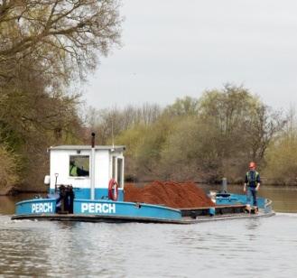
Transcription


1 RYALL NORTH QUARRY, WORCESTERSHIRE ENVIRONMENTAL STATEMENT NON TECHNICAL SUMMARY VOLUME 3 March 2015
2
3 ENVIRONMENTAL STATEMENT NON TECHNICAL SUMMARY VOLUME 3 Proposed sand and gravel quarry Land north of Ryall, Worcestershire Client: CEMEX Job no Document title: Environmental Statement Non Technical Summary Volume 3 Status: Final Date: Ref: NTS
4
5 CONTENTS CONTENTS 1.0 INTRODUCTION Background The Application Site The Proposed Development The Non Technical Summary Technical Studies Document Availability THE PROPOSED DEVELOPMENT General Overview Phased Quarry Development Scheme Phased Working Scheme Hours of Operation Mineral Processing RESTORATION STRATEGY Introduction Restoration principles SUMMARY OF ENVIRONMENTAL ISSUES Introduction Landscape and Visual Effects Ecology Agriculture and Soil Resources Surface and Ground Water Noise Air Quality Traffic Cultural Heritage CONCLUSIONS LIST OF FIGURES Figure Site Location Plan... 4 Figure 3-1 Phase Figure 3-2 Phase Figure 3-3 Phase Figure 3-4 Phase Figure 3-5 Phase Figure 4-1 Restoration Plan Ryall North Quarry P a g e i SLR Consulting Limited
6
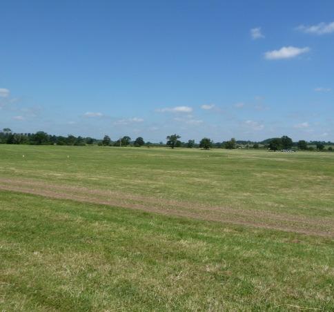
7 1.0 INTRODUCTION 1.1 Background A planning application has been submitted by and CEMEX UK to Worcestershire County Council (WCC) which seeks planning permission for for the extraction of sand and gravel from land north of Ryall in the Severn Valley. A plan illustrating the location of the application site is produced as Figure 1-1. The development at the application site, referred to as Ryall North, is intended to provide a source of sand and gravel for processing at the existing Ryall House Farm Quarry plant, which lies some 2km to the south. Ryall House Farm Quarry is an established sand and gravel quarry located approximately 1.5km to the south east of Upton on Severn, and some 12 km to the south of Worcester. It has been worked since 1990 and benefits from a full processing plant and related infrastructure, including access onto the A38. Reserves of sand and gravel at Ryall House Farm Quarry are fully worked out. At present sand and gravel is being worked from land near Ripple (located some 2km south of Ryall House Farm Quarry either side of the M50 Queenhill motorway bridge), and transported to the processing plant at Ryall House Farm Quarry by barge along the River Severn. Reserves at Ripple will be exhausted by the summer of 2015, and Ryall North is intended to act as a replacement source of sand and gravel. The sand and gravel from Ryall North would similarly be transported by barge along the River Severn to Ryall House Farm Quarry, and, like Ripple, there would be no processing operations at the Ryall North site. 1.2 The Application Site The proposed Ryall North extraction area lies to the north west of the villages of Ryall / Holly Green, some 600m north of Upton on Severn and approximately 800m to the east of Hanley Castle / Church End. The application site extends to approximately 50.3hectares (ha) of which the proposed extraction area is some 32.5 hectares in extent. It comprises a series of fields and part fields lying to the east of the River Severn. The site is essentially flat with levels averaging 11m AOD. The fields within the application site are in agricultural use, partly arable and partly pasture, and with ocassional intermittent / gappy hedgerows and isolated former hedgerow trees. The southern area of the site is bisected by an agricultural track running east to west between Ryall Court Farm and the River Severn. The application site also includes two smaller areas of land linked to the main body of the application site by narrow corridors. To the west, and situated adjacent the banks of the River Severn, an area of some 3.8 ha would accommodate the proposed wharf and associated infrastructure, whilst to the east, and located on higher ground, an area of 5.5 ha would be used for the storage of soils. The mineral extraction area of the application site lies between 210m and 340m from the banks of the River Severn, with the intervening land being in agricultural use and lying at a similar elevation to the application site. To the south, and bounding the application site is an overhead electricity transmission line. To the east is further agricultural land, together with a track, which serves as a bridleway. Access to the site would be derived off a minor road (Ryall Court Lane) which leads off the A4104 immediately north of Holly Green/Ryall, and which provides access to Ryall s Court Farm. A number of rights of way exist within and in the vicinity of the application site. Brideleway No 508 runs parallel with the eastern bank of the River Severn and forms part of the Severn Way continuing south across Upton Bridge and along the west bank of the River Severn, and Ryall North Quarry P a g e 1 SLR Consulting Limited
8 north towards Severn Stoke and beyond. Footpath No 511 runs in a northerly direction from the A4104 for a distance of some 300m before diverting into FP501 and FP 508. FP 501 runs in a northerly direction through the eastern area of the application site, although the route is not evident on the ground in view of the arable use of the fields. FP 508 runs in a north easterly direction to join Bridleway 506 which runs in a northely direction from the A4014 some 200m to the east of the application site, continuing parallel with the application site passing to the west of Ryall s Court Farm and Day House Cottages to join a second bridleway running east to west from the A38 (to the north of Earl s Crombe), and the Severn Way. 1.3 The Proposed Development The scheme makes provision for: i) The phased extraction of some 1.4 tonnes (net) of sand and gravel from the defined extraction area; ii) The establishment of wharf and related infrastructure alongside the River Severn for the loading of sand and gravel into barges for transportation to the existing processing facilities at Ryall House Farm Quarry; iii) The progressive restoration of the extraction area to provide for an amenity / nature conservation lake with shallow margins designed to encourage bio diversity; iv) The temporary diversion of public footpaths which currently cross the extraction area, and their re instatement on existing or new routes as part of the restoration scheme. 1.4 The Non Technical Summary An Environmental Impact Assessment (EIA) has been undertaken to consider the environmental effects of the proposed development. The results are presented in an Environmental Statement which accompanies the planning application. This document is a non technical summary (NTS) of the Environmental Statement (ES), and presents the main findings of the Environmental Impact Assessment (EIA) in non technical language. The NTS, as the title suggests, provides only a brief summarised account of a large amount of technical reports and data. However, it is intended to provide a sufficient overview of the development scheme, and the environmental issues which would be associated with the development, to allow the reader to gain an understanding of the key issues, and the way in which the EIA has informed the preparation of the proposed development scheme. The NTS comprises Volume 3 of a comprehensive submission which consists of: Volume 1: Environmental Statement (ES); Volume 2: Technical Appendices; and Volume 3: Non Technical Summary of the ES (i.e. this document). The planning application is supported by a Planning Application Statement (PAS) which includes the formal application plans which illustrate the details of the proposed development. Selected plans are reproduced in this NTS for ease of reference. 1.5 Technical Studies As part of the EIA, technical studies have been undertaken to consider the effect of the development in terms of: Landscape and Visual Impact; Ecology; Soils and Agricultural Land; Hydrology and Hydrogeology; Noise; Air Quality; Transportation; and Cultural Heritage. Hints Quarry P a g e 2 SLR Consulting Limited
9 In addition, technical inputs on the design of the working scheme, geology and reserve assessment, have been provided by in-house expertise at CEMEX. 1.6 Document Availability The ES volumes are available for inspection at the offices of Worcestershire County Council, County Hall, Spetchley Road, Worcseter WR5 2NP. Copies may be purchased from the Applicant at CEMEX UK Operations Limited, Wolverhampton Road, Oldbury, Warley, West Midlands B69 4RJ (tel ). The cost of volumes (inclusive of VAT and postage) is: ES Volumes 1 3 and Planning Application Statement: Printed versions CD version 5.00 Volume 3 NTS: (Printed version) 5.00 Ryall North Quarry P a g e 3 SLR Consulting Limited

10 Figure Site Location Plan Hints Quarry P a g e 4 SLR Consulting Limited
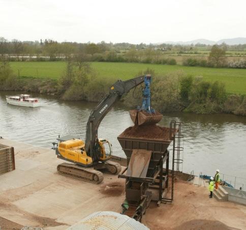
11 THE PROPOSED DEVELOPMENT THE PROPOSED DEVELOPMENT 2.1 General Overview It is proposed to develop the site in a similar manner to the operation at Ripple, with phased extraction of sand and gravel as a series of campaigns. These would take place up to 4 times a year over periods of up to 7 weeks. The sand and gravel would be transported to a temporary storage area adjoining the proposed wharf, and material from the storage area would then be progressively used to load the barges for transportation of the sand and gravel to the processing plant site at Ryall House Farm Quarry. Outside of the extraction campaigns, activities other than restoration works would be confined to the intermittent barge loading operations. The site would be progressively restored on a phased basis extraction on a phase by phase basis, minimising the extent of operational land at any one time. An average of 12 barge loads per day (180 tonnes per load) would be transported from the wharf to the Ryall House Farm Quarry processing plant site. The proposed development would benefit from existing infrastructure located at Ryall House Farm Quarry in terms of the processing plant, weighbridge and office accommodation. As is the case at Ripple, there would be no transportation of aggregates by road from the application site. The site would be progressively restored primarily to a landscaped amenity lake with the adjoining areas restored to agricultural use. The development would comprise three distinct phases: (i) The preliminary works associated with soil and overburden stripping from the initial extraction phase, the development of the wharf loading facility, and related site infrastructure associated with the preparation of the storage pile area and internal haul roads; (ii) The phased extraction of minerals together with progressive restoration; and (iii) The final restoration of the site and associated aftercare. 2.2 Phased Quarry Development Scheme Preliminary works Access to the application site would be taken from Ryall Court Lane, which joins the A4104 immediately north of Ryall. Ryall Court Lane provides access to Ryall s Court Farm, beyond which existing farm tracks lead to the application site. A series of new tracks would be constructed on site, to allow movements between the extraction areas, storage areas and the wharf. The wharf would be constructed on the banks of the River Severn in the location chosen to minimise visual effects when viewed from properties on the opposite west bank of the River Severn. The barges would be loaded via an inclined conveyor, fed by a feed hopper located behind the existing flood defences. The surge pile of excavated sand and gravel would be located to the south west of the wharf. At its maximum extent it would contain approximately 25,000 cubic metres, which would then be gradually reduced before being replenished as part of the next campaign extraction programme. The surge pile area would be aligned north east to south west parallel with the River Severn flood barrier and parallel with the flow of any floodwater which enters the site. A separate application has been submitted which seeks a localised diversion of Bridleway 508 to a route to the east of the loading hopper and inclined conveyor. This would ensure that users of the bridleway would be able to proceed along the BW unhindered by the conveyor and related infrastructure associated with the barge loading. Warning signs would be erected at an at grade bridleway crossing point from the surge pile to the loading hopper. Ryall North Quarry P a g e 5 SLR Consulting Limited
12 THE PROPOSED DEVELOPMENT Phased Working Scheme Introduction The sand and gravel extraction scheme would progress in 5 phases, as illustrated on Figures Phase 1 Operations in Phase 1 (Figure 3.1), would commence with the separate stripping of the topsoil and subsoil from Phase 1, which would be placed in a soil storage area to the north east of the extraction area, outside the main River Severn flood plain. Sand and gravel extraction would then commence as an initial campaign which would extract some 25,000 m 3 which would be placed in the wharf storage pile area. The sand and gravel is overlain by a thickness of some 2m of clay overburden. This overburden would be retained within the working void, and used to progressively profile the margins of the void as part of the initial restoration works. Successive campaigns would then be undertaken to replenish the surge pile, with an anticipated 4 x 7 week extraction campaigns per annum over the 2.5 year phase 1 period. The anticipated circumstances at the site at the end of Phase 1 are illustrated on Figure Phase 2 Operations in phase 2 would commence with the separate stripping of the top soil and sub soil, which would be placed direct into the eastern and western margins of phase 1 to progress the profiling of the margins of the future amenity lake. A temporary soil screen bund would be positioned to the west of Days House Cottage for the duration of extraction and restoration works within phase 2. The overburden would be progressively extracted and similarly used for re-profiling operations either direct to the margins of the worked out extraction area, or temporarily stored at the base of the excavation pending use in the restoration works. Sand and gravel extraction would then commence, working from south to north, again on a campaign basis. The anticipated circumstances at the site at the end of Phase 2 are illustrated on Figure Phase 3 Preliminary works in Phase 3 would comprise the stripping of the top soil and sub soil which would be used to progress the re-profiling and restoration works along the north eastern margin of phase 2. This would be supplemented by overburden stripped from Phase 3. Upon completion of these re-profiling and restoration works, the temporary soil screen bund to the west of Days House Cottages would be removed. Sand and gravel extraction in phase 3 would then progress working from north to south again on a campaign basis. The anticipated circumstances at the site at the end of Phase 3 are illustrated on Figure Phase 4 Preliminary works in Phase 4 would follow the established pattern of the stripping of the top soils, sub soils and overburden, which would be used for direct re-profiling and restoration works within Phase 3. Sand and gravel extraction in phase 4 would progress from phase 3 in a north south direction to the defined southern boundary, fixed by a line parallel to the existing overhead power line. The anticipated circumstances at the site at the end of Phase 4 are illustrated on Figure 3.4. Hints Quarry P a g e 6 SLR Consulting Limited
13 THE PROPOSED DEVELOPMENT Phase 5 The final extraction phase would similarly follow the established pattern of operations, with the soils and overburden used to progress and complete restoration in Phases 3 and 4. Sand and gravel extraction would progress in a generally south / south east direction from the exposed faces on the southern and eastern edges of phases 3 and 4 to the defined southern boundary of phase 5. The anticipated circumstances at the site at the end of Phase 5 are illustrated on Figure Hours of Operation The operational hours associated with the extraction and transportation of aggregates at the site would reflect the existing hours of working at the Ripple satellite site, namely: Mondays to Fridays; and on Saturdays. No working is allowed on Sundays and Bank Holidays. 2.5 Mineral Processing As confirmed above, there would be no processing of sand and gravel within the application site. Excavated sand and gravel would be transferred from the working face to the storage area by dump trucks, from where it would be loaded onto barges for transportation to the processing plant located at Ryall House Farm Quarry. Ryall North Quarry P a g e 7 SLR Consulting Limited
14
15 Figure 2-1 Phase 1 Ryall North Quarry P a g e 9 SLR Consulting Limited
16 Figure 2-2 Phase 2 Hints Quarry P a g e 10 SLR Consulting Limited
17 Figure 2-3 Phase 3 Ryall North Quarry P a g e 11 SLR Consulting Limited
18 Figure 2-4 Phase 4 Hints Quarry P a g e 12 SLR Consulting Limited
19 Figure 2-5 Phase 5 Ryall North Quarry P a g e 13 SLR Consulting Limited
20 Hints Quarry P a g e 14 SLR Consulting Limited
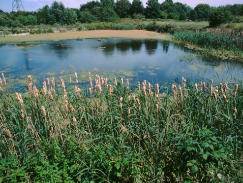
21 3.0 RESTORATION STRATEGY 3.1 Introduction Worcestershire County Council has produced a series of documents which set out principles for restoration of mineral working sites. In particular these include: Biodiversity and Mineral Sites in Worcestershire: Guidance for the Sustainable Management of Biodiversity Action Plan Habitats at Worcestershire Mineral Sites; Worcestershire Green Infrastructure Strategy; Worcestershire Habitat Inventory: Green Infrastructure Wetland ; and Ryall North - Mineral Working and Restoration for Green Infrastructure: Concept Statement. The Concept Statement defines a series of key objectives to: Create lowland wet grassland and water meadow habitats; Provide a layout of ditches to reflect historic field enclosure patterns; Enhance planting along hedges and ditches; and Provide as much marginal habitat as possible along existing and new watercourses, ponds and other watercourses. 3.2 Restoration principles Based upon the above guidance and feedback from public consultation (public exhibition 13 th and 14 th November 2014), the key design principles for the proposed restoration scheme have been to create a multi-functional area of benefit to local residents and to wildlife. The scheme is thus based upon establishing a lake with a more open area of water to the south which is intended for public access and amenity and would be suitable for fishing, boating and quiet recreational pursuits, and a smaller, narrower and more sheltered body of water for wildlife conservation to the north. The junction of these two areas has been designed to include a narrowing of the area of water to reinforce the separation of the two after uses. A basic restoration profile has been applied to the lake shore with shallow gradients to a depth of 1m below the final water level, with a wide bench to create scrapes and shoreline features with gentle gradients to tie into the existing ground levels around the edge of the restored area. The shoreline of the resultant lake has been designed to create a large number of bays and promontories and wider areas of shallow water for the establishment of reed beds and wetland plant species. To the south the lake is bounded by traditional grassland to provide open access to the shore for visitors, whilst to the north the focus on nature conservation has resulted in the creation of more extensive reed-beds, larger areas of swales and wet grassland. The suggested additional measures to ensure that biodiversity and habitat creation is maximised are shown on the restoration plan and could include the creation of a wildlife viewing area screened by hedge and scrub planting at the northern end of the site. It is considered that this approach is consistent with one of the key aims of the Green Infrastructure Concept Statement to deliver net biodiversity gain. In addition, areas of hedgerow planting which would be supplemented by the introduction of standard hedgerow trees, with limited areas of scrub woodland planting proposed to shelter the conservation area would further diversify the restoration habitats. Also, as suggested by the Green Infrastructure Concept Statement, the re-creation of former hedges and ditch lines around the lake are intended to re-establish landscape connectivity. The resultant restoration plan is illustrated in Figure 4.1. Ryall North Quarry P a g e 15 SLR Consulting Limited
22 Figure 3-1 Restoration Plan Hints Quarry P a g e 16 SLR Consulting Limited
23 4.0 SUMMARY OF ENVIRONMENTAL ISSUES 4.1 Introduction The Environmental Statement (ES Volume 1) has considered the potential environmental effects of the proposed sand and quarry at Ryall North. Based upon the studies and content of the individual chapters, the underlying conclusion of the EIA is that there is no single topic, or combination of issues which should objectively prevent the development from proceeding. This in part reflects the fact that allocation of majority of the site in the adopted Hereford and Worcester Minerals Local Plan as a preferred area for future sand and gravel extraction, and the acknowledged general environmental suitability of the site for the proposed development (as discussed in more detail in the Planning Application Statement). The respective environmental studies have assessed the effects of the proposed development and where relevant, the studies have made a series of recommendations for measures which could minimise effects, and/ or result in positive enhancements. These issues are summarised below as a brief resumé of the preceding chapters and the conclusions which are drawn. For each topic, the summary describes the key elements of the study which has been undertaken, the mitigation measures which have been incorporated into the design of the working and restoration scheme or which will be implemented as part of the development, and the assessed residual effects taking into account the mitigation measures. 4.2 Landscape and Visual Effects Landscape Impact The direct effects on the landscape within the application site would remove a limited number of trees and hedgerows. The proposal to extract sand and gravel and to restore the land to a lake would introduce a new character to the area, but this would not be inappropriate to the position of the site on the river flood plain. The other aspects of the development including the wharf, haul route and surge pile are all considered to be temporary uses of the land and the impact on those areas is considered to be reversible Visual Impact Visual impact is generally well restricted by vegetation and landform, and almost all views are within a short distance of the site. Existing vegetation is concentrated towards the south end of the proposed extraction area, whereas the northern section is more open. Most views would occur from public rights of way, with impacts increasing towards the north end of the site. Day House Cottages and the Severn Way are particularly sensitive to visual impact. However, the Severn Way is more distant from the extraction area and as such perceived change and hence impact would be lessened. There would be temporary effects at Day House Cottages during soil stripping and construction of the soil screen bund, and when extraction is taking place in phase 2 and extraction reaches the northern limit of phase 2 (albeit with extraction operations screened by the bund). After that period impacts would be much less and declining as the restoration matured. In the long term the presence of the lake is considered to enhance the views from that area. Views on the Severn Way would be of significance as it passes through the wharf area due to the visible operations and mineral storage. These views would quickly diminish with distance, but would last for the life of the extraction period. These views may not necessarily be regarded as Ryall North Quarry P a g e 17 SLR Consulting Limited
24 negative as they provide a focus of interest on the water, and perception is likely to be very subjective in nature. Overall the identification of these visual impacts has to be balanced by the restricted visual impact for the development in general Landscape Mitigation measures A number of in-built mitigation measures have been included within the development proposals including the phased programme of working and restoration, the direction of working, and the proposal to process the material off-site at the main Ryall House Farm Quarry. The apparent size and extent of the extraction area would be restricted by a phased working and restoration scheme. In addition, the campaign nature of the soil stripping and extraction would minimise the time that disturbance was visible, other than for views of the wharf area. A hedgerow would be planted along the southern edge of the extraction area. This area would be one of the last to be extracted and thus the hedgerow would have around 6 years to develop, and would assist in screening the final phases of the development. This hedge would in part replace existing hedgerows that would be lost from within the extraction area. The key medium term mitigation measure is the restoration scheme itself which seeks to maintain and enhance the landscape and ecological value of the site, which would include: Creation of a new lake linked to the existing network of ditches around the site in order to maximise ecological value; Enhancement of retained hedgerows through infill planting and hedgerow tree planting; Planting of replacement hedgerows around site perimeter to reinforce the landscape character; Translocation of sections of hedgerow which would be removed as part of the development; Selective planting along water course and ditches; Small areas of dry and wet woodland planting; and Creation of new wetlands including open water, marginal aquatic habitats and damp margins. These habitats would be linked to the existing network of ditches around the site in order to maximise their value Landscape Conclusions Opportunities exist to ameliorate some of the potential impacts and provide for some beneficial impacts/ enhancements, principally through ecological diversification, as part of the restoration and management of the site in the medium to long term. The surrounding landscape would be minimally affected by the development during working, and unaffected upon completion. Of the viewpoints which have been assessed, most have restricted views of the application site, principally due to a combination of a largely flat landscape and intervening vegetation. However, viewpoints in elevated locations or situated in close proximity to the working or along the footpaths on either sides of the site are more susceptible to potential visual impacts. However, these would be of generally short duration (Days House Cottage) or of restricted areas (wharf). 4.3 Ecology Ecology Study A series of habitat and species surveys have been carried out whic confirm that the ecological receptors within and in the vicinity of Ryall North comprise:- Three Statutory Wildlife Sites comprising:- o Upton Ham SSSI; o Earl s Croome Meadow SSSI; and o Brotheridge Green Meadows SSSI. Hints Quarry P a g e 18 SLR Consulting Limited
25 Four Non-Statutory Wildlife Sites comprising:- o River Severn LWS; o Pool and Mere Brooks LWS; o Holly Green Meadows (WGI); and o Severn Bank Meadow (WGI). UK BAP Priority Habitats comprising:- o c. 189 m stretch of Rivers ; o c ha of Eutrophic Standing Waters ; o c ha of Ponds ; o c ha of Arable Field Margins ; and o c m of Hedgerows. Four veteran trees; A small non-breeding population of great crested newts (comprising two males) in one on-site pond in the south of the site, and a medium population of great crested newts in an off-site pond c. 80 m to the east; Four common toads; Barn owls, known to be present (non-breeding) within the site; A suite of nesting birds; Badgers, with one unoccupied single-hole outlier sett in the site; Otters (considered due to their presence on the River Severn and within LWS); A single bat roost; and A suite of foraging and potentially roosting bats. There would be no direct negative impacts upon the Statutory and non statutory Wildlife Sites and no material indirect effects. The proposed development would result in the permanent loss of four veteran trees, as well as a the existing habitats within the site comprising some ha of habitat and 1921 m of linear habitat, and including the 0.05 standing waters, and 0.37 ha of Arable Field Margins. In the absence of mitigation measures, the development also has the potential to impact on the protected species identified as being present within and in the vicinity of the site Ecology Mitigation measures Habitats The restoration scheme has been designed to compensate for the loss of habitats of importance and be sympathetic towards nature conservation priorities. The restoration scheme will encompass five UK BAP Priority Habitats, occupying a total of c ha and c m. The five UK BAP Priority Habitats comprise:- Approximately 16.2 ha of Lowland Meadows ; Approximately 1.1 ha of Reedbeds ; Approximately ha of Eutrophic Standing Waters ; Approximately 0.09 ha of Ponds ; and Approximately 1750 m of Hedgerows. The restoration scheme therefore ensures there will be no net loss of three existing UK BAP Priority Habitats comprising Eutrophic Standing Waters, Ponds and Hedgerows, but in fact a gain of c ha, c ha and c. 635 m respectively. The restoration scheme also envisages the gain of two new UK BAP Priority Habitats comprising Lowland Meadows and Reedbeds, as well as the retention of an existing UK BAP Priority Habitat comprising Rivers. Therefore, following the restoration, the Ryall North site will encompass a total of six UK BAP Priority Habitats. Furthermore, eight black poplar trees will be incorporated on field corners within new hedgerow planting. A Species Action Plan for black poplar exists within the Worcestershire Biodiversity Action Plan. Ryall North Quarry P a g e 19 SLR Consulting Limited
26 Great Crested Newts Great Crested newts have been found in a small pond in the southern phase 5 area of the site (referred to as pond 3. The maximum number of great crested newts was five in 2005 and two in However, breeding was not confirmed in either year and in 2014 only two adult male newts were encountered. No great crested newts were recorded in Ponds 1 or 2 in the central and northern areas of the site. This is considered to result from barriers to their movements across the site in the form of trapezoid drains which carry flow across the site and into the River Severn. In addition, the full extent of the site and substantial areas outside the site, lie within the floodplain of the River Severn. Following a flood event, great crested newts would be unable to re-colonise the development site until water within the field-drains was sufficiently low and flow sufficient weak, to allow them to cross. Once newts had crossed these drains, seasonal increases in the flow of the drains would mean they were then cut-off by variations in north/south and south/north flow of drains throughout the site and would then be at risk from drowning if they were hibernating within the floodplain. The detailed great crested newt strategy is outlined within an Ecological Management Plan which accompanies the ES. This makes provision for the creation of new ponds and the re-location of great crested newts into these ponds.. No work that might disturb or destroy potential bird nesting habitat will be undertaken within the accepted bird breeding season (1 st March to 31 st August) unless survey by an experienced ornithologist has determined that nesting birds are not present. The results of the badger survey in 2014 identified the presence of ten setts, of which a single outlier sett lies within the development footprint and extraction boundary. Prior to soil stripping and earth movements within each phase of the development, a walk-over badger survey would be undertaken by an experienced ecologist to ensure that no occupied badger setts are present within the development footprint. The results of these surveys will be used to define an appropriate stand-off from setts outside the development footprint. If an occupied badger sett is recorded within the development footprint, a licence may be required from Natural England in order to close the sett and allow works to proceed. No potential otter holt sites were identified on the eastern bank (the bank included within the development footprint), and it is therefore concluded that otter presence will be transient and limited to animals hunting or commuting along the River Severn. The bat survey identified the presence of a single bat roost within an oak tree which is earmarked for removal during Phase 4 of the working scheme. Therefore a programme of mitigation and compensation is proposed. To ensure there is no net loss of bat-roosting opportunities in the site, compensation will comprise the provision of artificial bat-roost boxes in locations to be agreed Ecology Conclusions With the implementation of the mitigation measures which have been proposed, no adverse residual ecological impacts are anticipated. There are no thus ecological constraints to mineral development at Ryall North. In contrast, significant biodiversity gains are anticipated from the restoration scheme. 4.4 Agriculture and Soil Resources ALC and Soil Study The published 1:63,360 Agricultural Land Classification (ALC) Map (Sheet shows most of the application site as undifferentiated land of Grade 3 quality. Hints Quarry P a g e 20 SLR Consulting Limited
27 Based upon a more detailed soil survey, undertaken in accordance with the up to date revised ALC system, the site was found to contain roughly equal amounts of land of Sub-grade 3a and Sub-grade 3b quality. The site inspection confirmed the distribution of the three soil types referred to as:- Soil Type A - Moderately well drained soils in alluvium; Soil Type B - Poorly drained soils in clayey alluvium; and Soil Type C - Well drained loamy soils in terrace deposits Mitigation Measures Because of the location of the site within the Severn floodplain, the opportunities for agricultural restoration are limited. This has been recognised in Chapter 4.0 (Restoration), and the restoration proposals seek to enhance the biodiversity of the area through the creation of new wetland habitats. Thus the proposed lake margins would be restored to grassland with scrapes and low gradients. The high ground water levels would enable the retention of moisture with the soil horizon, aiding the establishment of wet grassland. Detailed soil handling protocols are described based upon established techniques of soil stripping, storage and restoration which would ensure no adverse effect to soil resources Agriculture and Soils Conclusions The soil resources would be used beneficially for the restoration land uses proposed in Chapter 3.0 above. 4.5 Surface and Ground Water upon Severn. The River Severn flows in a southerly direction past the application site, via its confluence with the River Avon at Tewkesbury approximately 8km to the south, to discharge to the Severn Estuary near Gloucester. The topography of the application site is essentially flat lying at between 10.2m and 11.8m Ordnance Datum (OD) and rises relatively steeply to the east of the, up to 38m AOD. A number of minor drains and ditches cross the application site which discharge to the River Severn via flap valves. A detailed flood risk assessment has been prepared which indicates that almost the entire application site lies within the floodplain of the River Severn. The Environment Agency has confirmed 1 that the application site lies within Flood Zone 3 (with a small area in Flood Zone 2). Flood Zone 3 is defined as the area of high flood risk where the annual probability of flooding is greater than or equal to 1%. The Agency has confirmed that the outskirts of Upton upon Severn are subject to frequent flooding, with the sources of flood risk being both the River Severn and Pool Brook, a westerly tributary of the River Severn. There are existing flood defences along this stretch of the River Severn between Ryall and Severn Bank on the east bank adjacent to the application site and also from Hanley Castle to Cliffey Wood on the west bank. These defences are agricultural defences and offer protection up to a 1 in 5 year event. The Environment Agency has confirmed that there are ten licensed surface water abstractions within 3km of the application site and three licensed abstractions from groundwater within 3km of the application site. None of these abstractions are within the radius of influence of the dewatering operations which would be undertaken at the quarry Surface and Groundwater Study The application site lies to the immediate east of the River Severn within a gentle meander of the river channel just to the north of the town of Upton 1 Environment Agency letter dated 23 November 2004, EA Ref: LS/CS/ Ryall North Quarry P a g e 21 SLR Consulting Limited
28 Groundwater abstracted during dewatering activities would be discharged, following settlement, to the River Severn. Therefore no residual losses of flow within the River Severn would be anticipated Flood Risk Assessment The Flood Risk Assessment considers the potential impact of the proposed development on local flood risk and surface water runoff. It is noted that no built development or land raising (other than the temporary sand and gravel storage pile) is proposed within the floodplain throughout the life of the site. The main soil stockpiles would be placed outside of the flood zone, with a small soil screen bund at Ryall House Cottages aligned in the direction of any flood flow. It is proposed that all plant on site would be mobile and would be moved out of the floodplain in response to flood warnings. The proposed development of a loading wharf adjacent to the River Severn would be located within the floodplain but would be of limited dimensions. The presence of a quarry void within the floodplain would increase flood flow movement conveyance, and calculations within the FRA show that the net effect would be an overall lowering of flood levels and a consequent small reduction in flood risk locally. Dewatering is proposed to facilitate working of the mineral and appropriate authorisations including an Environmental Permit and Flood Defence consent would be obtained from the Environment Agency for the proposed works. The long term site restoration proposals are to open water. The final post-development topography would be equal to or lower than the current pre-development topography with restoration using site derived soils and overburden. Therefore the post-development site would not increase local surface water runoff rates nor be at greater risk of flooding than pre-development. Indeed the final, lower topography and restoration to open water would reduce runoff rates and provide additional floodplain storage (above the rest water level) relative to predevelopment conditions Mitigation Measures Given the location of the application site within Flood Zones 2 and 3, no ground raising is proposed within the floodplain. All soil/overburden stockpiles would be constructed outside of the floodplain in the eastern part of the site. The mineral storage pile at the wharf site would be temporary only, and kept to a minimum required for barge loading. Any loss of floodplain would be compensated by storage provided within the quarry workings (above rest groundwater level). It is recommended that the quarry operators register with the Environment Agency Floodline Warnings Direct service, to obtain flood warnings by phone, text and . These should be used as triggers for the orderly evacuation of the site, prior to the onset of flooding. A number of general pollution prevention measures would be employed to ensure that both ground and surface waters are not contaminated at any stage of the development. The development would be constructed, operated and restored in line with relevant Pollution Prevention Guidelines and other codes of best practice Surface and Ground Water Conclusions The surface and groundwater regimes at the application site have been assessed with reference to information held by the Environment Agency, Local Authorities and others, and by the consideration of site specific investigation and monitoring data. Due to the proposed method of working and site restoration, potential impacts to water quality, flood risk and water resources have been identified. A number of appropriate mitigation measures have been identified, including good site practice, the inclusion of settlement lagoons for abstracted water and the provision of flood storage. Hints Quarry P a g e 22 SLR Consulting Limited
29 Overall, it is concluded that, with respect to the water environment, there are no significant residual impacts of the development after consideration of the identified mitigation measures. 4.6 Noise Noise Study The methodology for the noise study follows the advice and approach to suggesting site noise limits as set out in the Planning Practice Guidance (PPG) to the National Planning Policy Framework (NPPF). Operational noise levels generated by the mobile plant associated with operations at the site have been predicted and have been assessed against the guidance contained in the PPG. The predicted noise emissions have been compared against the existing average background noise around the application site measured at four representative properties, and the noise limits at these properties have been calculated based on the guidelines in the PPG. The noise limits are based upon the advise in PPG that, under normal circumstances, noise from the site should not exceed the existing background (L A90 ) noise level by more than 10dB, and should in any event not exceed a maximum of 55dB L Aeq,1hr. The development includes an in built design mitigation measures in the form of a noise screen bund to the west of Days House Farm Cottages. The assessment has shown that in the absence of further mitigation the predicted noise emissions due to normal operations at the site will, with one exception, be below the proposed noise limits at the nearest noisesensitive receptors and therefore negligible impacts are anticipated at these receptors. The exception referred to is at Days House Cottages where in the absence of further mitigation the proposed noise limits will be exceeded by just over 1 db during Phase 2 operations at the northern extent of the site. When works are undertaken at distances further than 300m from Days Cottages, (i.e. towards the southern extent of Phase 2) the noise levels are within the proposed noise limits. It should be noted, however, that predicted noise levels during Phase 2 operations at the northern extent of the site are still within the 55dB L Aeq,1hr maximum limit for normal operations recommended within the PPG Noise Mitigation Measures The predicted noise levels do not take into account the attenuation that may be provided by the quarry face as extraction takes place at an average depth of approximately 6m below ground level. With the inclusion of this additional mitigation measure, the predicted noise levels for normal operations during Phase 2 (in the northern part of this phase and taking into account attenuation provided by the quarry face ) will be below the proposed noise limits at all locations assessed. The construction of infrastructure associated with the development (the wharf, internal haul routes etc.) and soil stripping would be confined to periods of no more than eight weeks in any year where the noise levels would be considerably below the noise levels allowable for temporary operations (70dB L Aeq,1hr for up to eight weeks per year) Noise Conclusions With the implementation of the recommended mitigation measures, and inclusion of the barrier attenuation provided by working at the base of the sand and gravel deposit to extract the mineral, the assessment has found that: noise levels generated by infrastructure development and soil stripping would meet the proposed noise limits based upon advice in PPG at all assessed locations; noise levels generated by infrastructure development and soil stripping would be within the maximum noise limit (55dB L Aeq,1hr ) allowable for normal operations; and Ryall North Quarry P a g e 23 SLR Consulting Limited
30 noise levels associated with temporary operations would below that allowable for temporary operations (70dB L Aeq,1hr for up to eight weeks per year). It should also be noted that the campaign nature of the sand and gravel extraction operations would ensure that the principal noise source (extraction and transportation of the sand and gravel to the wharf surge pile) would be confined to approximately 4 x 7 week periods per annum. 4.7 Air Quality Air Quality Study The assessment has considered the potential impacts on air quality as a result of the proposed development at Ryall North Quarry. The potential impacts of the development have been assessed in terms of potential emissions of particulates (dust). Two assessments have been undertaken; the first to assess the fine dust fraction, referred to as PM 10 for which Air Quality Standards exist, and the second to assess the coarse fraction dust which is typically associated with amenity issues. The assessment found that the existing background PM 10 level is well below the national air quality standard and the risk that operations will give rise to an exceedance of this standard is low. The assessment has identified the potential sources of amenity (coarse) dust on site. However, the implementation of dust control measures as part of routine good management are considered to be effective and therefore impacts are considered to be insignificant. The potential for dust impacts on the surrounding ecological sites has been assessed as insignificant Air Quality Mitigation Measures Mitigation measures for the stripping of soils / overburden, the storage and the subsequent restoration activities should focus on the sensible timing of operations and good site management in relation to rainfall, wind conditions and seasonal factors. Excavation would be undertaken in campaign digs, each campaign with a duration of approximately 7 weeks. Given the proximity of the water table to the surface of the application site, the mineral is likely to be extracted with a high moisture content which is likely to minimise dust emissions. In the unlikely event that mineral is allowed to dry out during these activities, control of dust should be aided through the use of water as and when required such as during dry and windy weather conditions Dust emissions during the transfer of material would be minimised by ensuring drop heights are minimised wherever practicable and vehicles are not overfilled for transfer to the wharf storage area. The storage of mineral is the only dust source that would be an ongoing operation throughout the circa 7 year duration of the development. Stockpile surfaces should be profiled and sprayed regularly, and to prevent the dispersion of material areas around the base of the stockpile should be clearly designated to ensure passing vehicles do not disturb dusty material and the area should be kept clean and in good repair. Haulage on temporary, compacted haul roads has been identified as one of the activities with the highest potential for dust emissions in the absence of mitigation. Haulage within the site would however be restricted as internal site transfers would only be required on a regular basis during the campaign digging operations. The majority of the time when there are no campaign digging activities there would be minimal use of the internal haul roads. Hints Quarry P a g e 24 SLR Consulting Limited
31 The primary control measure that should be employed on site is the surface treatment of the haul roads through the use of watering by a tractor and bowser. Maintenance of haul roads by grading also minimises dust emissions due to less erosion of the haul road by passing vehicles. Vehicle speed restrictions would also be implemented and enforced Air Quality Conclusions In summary the risk of dust impact at the receptor locations surrounding the quarry is considered to be reduced to an insignificant or acceptable level following the application of the mitigation measures described. 4.8 Traffic Traffic Study The development proposals provide for the extraction of 1.4 mt of sand and gravel over a period of some 7 years. All as-dug material would be transported by barge to the existing processing plant located at Ryall House Farm Quarry, and subsequently exported to local markets. There would therefore be no exports of material by road from the application site; the only movements generated would be those associated with the transportation of plant and machinery. It is anticipated that aggregate exports from Ryall House Farm Quarry would continue at current levels. It is proposed that the site would be accessed from Ryall Court Lane, which joins the A4104 at an existing priority junction. There is good visibility in both directions at the Ryall Court Lane / A4104 junction, with a 40MPH speed restriction along the A4014 in the vicinity of the junction. Ryall Court Lane is an unclassified public highway which provides access to Ryall Court Farm. The Lane is fully surfaced to the Farm, averaging 3.5m in width, with a series of informal passing points. The boundary of the planning application site links to the public highway at Ryall Court Farm, beyond which access to the main application site would be gained via existing agricultural roads and new internal access roads as appropriate. The A4104 provides access to the A38 approximately 400m north-east of Ryall Court Lane. Both the A4104 and the A38 are identified on the Worcestershire County Council Advisory Lorry Route Map, with the A38 designated a preferred lorry route. The A38 provides local access to the M50 motorway at Junction 1, which in turn provides access to the M5 motorway at Junction 8. Access to the application site would only be required for the movement of plant and machinery for soil stripping and excavation operations, including an excavator, articulated dump trucks, bulldozers and a wheeled loading shovel. Plant and machinery would be transported by low loader type HGV s. It is proposed to extract the mineral on a campaign basis, 4 times a year, with each period lasting around 7 weeks. Outside of these periods all plant and machinery would be removed from the application site, with the exception of the loading shovel, which would remain to load the barges. HGV movements to and from the application site would therefore occur approximately 4 times a year, with approximately 2 low loader trips (4 movements) each time. At most 5 full time workers would be based on site during periods of extraction, which would decrease outside of these times. The application site would therefore generate minimal light vehicle movements Rights of Way Bridleway No.508 follows the eastern bank of the River Severn within the vicinity of the application site. The bridleway, which is part of the Severn Way, passes through the application site where the proposed wharf facility is to be located. It is therefore proposed to divert the bridleway around the eastern perimeter of the wharf. The bridleway diversion would cross the wharf access track and therefore suitable measures would be put in place to warn both bridleway users and quarry workers against the possibility of any potential conflict. Footpath No. 511 runs in a northerly direction from the A4104 before dividing into Footpath No. 501 and Footpath No Footpath No. Ryall North Quarry P a g e 25 SLR Consulting Limited
NON-TECHNICAL SUMMARY
 Proposed Sand and Gravel Extraction and Associated Processing Operations with Restoration to a Mixture of Agriculture and Nature Conservation including Areas of Shallow Water at Hedgeley, Northumberland
PANSHANGER QUARRY, Hertfordshire
 PANSHANGER QUARRY, Hertfordshire Proposed enhanced restoration of Phases F & H Briefing Note 1 March 2015 INERT (INACTIVE) RESTORATION MATERIALS, CONTROLS AND OPERATIONS 1 Introduction This briefing note
University Park, Worcester Non Technical Summary December 2011
 University Park, Worcester Non Technical Summary December 2011 Introduction UW Wrenbridge LLP, a Joint Venture Company of the University of Worcester and Wrenbridge Land Ltd (the Applicants ) intend to
BREEDON NORTHERN LIMITED
 Non Technical Summary CONTENTS 1 INTRODUCTION... 1 2 SITE DESCRIPTION... 1 3 DESCRIPTION OF THE DEVELOPMENT... 6 4 NEED FOR THE DEVELOPMENT... 8 5 KEY ISSUES CONSIDERED IN THE ENVIRONMENTAL IMPACT ASSESSMENT...
Rempstone Extension - East Leake 2014
 Overall Restoration of East Leake Quarry Sand Martin Face Southern Agricultural Corridor Wetland Ponds/Conservation Corridor following Sheepwash Brook Reinstated Bridleway/Footpaths Southern Agricultural
Request for a Scoping Opinion by Provectus. Proposed Surface Mining of Coal on Land west off the A61, Hill Top Farm, Clay Cross, Derbyshire
 Request for a Scoping Opinion by Provectus Proposed Surface Mining of Coal on Land west off the A61, Hill Top Farm, Clay Cross, Derbyshire January 2012 Contents 1 Introduction & Background... 1 2 Site
NON-TECHNICAL SUMMARY
 NON-TECHNICAL SUMMARY THE HIDE, BISHOP AUCKLAND PROPOSED ECO CHALET DEVELOPMENT NON-TECHNICAL SUMMARY 1 Introduction 1.1.1 This non-technical summary for the (ES) prepared in relation to the proposed eco-chalet
Replacement Golf Course Facilities and Residential Development, Churston. Environmental Statement Non-Technical Summary
 Replacement Golf Course Facilities and Residential Development, Churston Environmental Statement Non-Technical Summary July 2011 Reproduced from the Ordnance Survey s map with the permission of the Controller
BLACK CAT QUARRY EXTENSION ENVIRONMENTAL STATEMENT NON TECHNICAL SUMMARY VOLUME 3
 BLACK CAT QUARRY EXTENSION ENVIRONMENTAL STATEMENT NON TECHNICAL SUMMARY VOLUME 3 October 2015 ENVIRONMENTAL STATEMENT NON TECHNICAL SUMMARY VOLUME 3 BLACK CAT QUARRY Extension of Black Cat Quarry with
Grantham Southern Quadrant Link Road Environmental Statement
 Grantham Southern Quadrant Link Road Environmental Statement Non Technical Summary Introduction Lincolnshire County Council (LCC) is submitting a planning application for the proposed implementation of
The Place Solar Farm
 The Place Solar Farm Environmental Statement Non-Technical Summary 28 August 2014 Produced for Prepared by St John s House Queen Street, Manchester M2 5JB Contents Contents... 2 1 Introduction... 3 1.1
Town and Country Planning (Environmental Impact Assessment Regulations) 2011 SCOPING OPINION
 2011 SCOPING OPINION") Town and Country Planning (Environmental Impact Assessment Regulations) 2011 SCOPING OPINION Application Site and Description of Development Proposed new quarry at Culham, Oxfordshire Land and Mineral
Town and Country Planning (Environmental Impact Assessment Regulations) 2011 SCOPING OPINION Application Site and Description of Development Proposed new quarry at Culham, Oxfordshire Land and Mineral
Barvills Solar Farm Environmental Statement Non-Technical Summary
 Barvills Solar Farm Environmental Statement Non-Technical Summary 13 March 2015 Produced for Prepared by St John s House Queen Street, Manchester M2 5JB Contents Contents... 2 1 Introduction... 3 1.1 Development
LAND AT WEST YELLAND. Environmental Statement Non-Technical Summary Welbeck Strategic Land LLP
 LAND AT WEST YELLAND Environmental Statement Non-Technical Summary Welbeck Strategic Land LLP May 2014 Quality Management Issue/revision Issue 1 Revision 1 Revision 2 Revision 3 Remarks Draft FINAL Date
Public Consultation. Land at Monks Farm, North Grove. Welcome
 Welcome Welcome to our public exhibition for development on Land at Monks Farm, orth Grove. Gallagher Estates and Gleeson Strategic Land are preparing an outline planning application for new homes, open
Inert Recycling (UK) Ltd Boxgrove Quarry Restoration Environmental Statement
 Ltd Boxgrove Quarry Restoration Environmental Statement") November 2013 Non-Technical Summary Empress House, 12 Empress Road, Lyndhurst, SO43 7AE Tel: 023 8028 3226 Email: waste.enquiries@wyg.com Introduction Background EIA is a process by which the environmental
November 2013 Non-Technical Summary Empress House, 12 Empress Road, Lyndhurst, SO43 7AE Tel: 023 8028 3226 Email: waste.enquiries@wyg.com Introduction Background EIA is a process by which the environmental
LAND AT HOWES LANE, BICESTER ENVIRONMENTAL STATEMENT NON-TECHNICAL SUMMARY. March 2017 Our Ref: Q70433
 LAND AT HOWES LANE, BICESTER ENVIRONMENTAL STATEMENT NON-TECHNICAL SUMMARY March 2017 Our Ref: Q70433 Contents 1 INTRODUCTION AND SITE DESCRIPTION... 1 2 EIA METHODOLOGY... 5 3 ALTERNATIVES... 6 4 DESCRIPTION
SOUTH CAMBRIDGESHIRE DISTRICT COUNCIL. Planning and New Communities Director
 SOUTH CAMBRIDGESHIRE DISTRICT COUNCIL REPORT TO: Planning Committee 9 January 2013 AUTHOR/S: Planning and New Communities Director S/2270/12/FL FEN DRAYTON 850m long flood defence embankment ranging in
Longbridge Town Centre Phase 2 Planning Application
 Longbridge Town Centre Phase 2 Planning Application Non-Technical Summary of the Environmental Statement December 2013 Introduction A full application for Planning Permission has been submitted to Birmingham
LONDON BRIDGE STATION ENVIRONMENTAL STATEMENT NON-TECHNICAL SUMMARY
 LONDON BRIDGE STATION ENVIRONMENTAL STATEMENT NON-TECHNICAL SUMMARY June 2011 1 EXECUTIVE SUMMARY 2 INTRODUCTION CONTENTS Page 2.1 Introduction 4 2.2 The Site 4 3 THE DEVELOPMENT 3.1 What is it? 5 3.2
SPG 1. * the northern and western sections which are open fields used for pasture and grazing;
 SPG 1 1.0 INTRODUCTION This development brief is based on the allocation of the Priors Hall site for employment and countryside recreational purposes in the Corby Borough Local Plan. The brief is intended
WELCOME GYPSY LANE. Wider Site Location plan. Proposals for the development of LAND OFF FOXLYDIATE LANE WEBHEATH. Proposals for the development of
 WELCOME The developers are preparing an outline planning application for a residential led development and need the community s views in order to develop the proposals further WHAT IS PROPOSED? A high
Ʊ ± ªº Œª ºª ø ª ª ± ª
 Ʊ ± ªº Œª ºª ø ª ª ± ª ø º Õ± ± ± Œ±øºÙ Õ ß Æª ø檺 ±Æ ƪ ø檺 æß Æ± Ʊ ª ø ø fl ª ª ± ê ø Õ øæß ª ª æªæ Ó ÔÌ Non-Technical Summary Introduction A planning application has been submitted to the Vale
Non-technical summary
 Non-technical summary Introduction NTS.1 is applying for outline planning permission for a residential development of up to 80 dwellings on land at Hambrook, on the northern fringe of Bristol. NTS.2 An
Frequently Asked Questions
 1. Where is Aylesbury Woodlands? Frequently Asked Questions Aylesbury Woodlands lies to the east of Aylesbury. It is bounded to the south by the A41. To the north is the Aylesbury Arm of the Grand Union
Rannoch 132 / 33 kv Substation Extension
 Who we are Scottish and Southern Energy Power Distribution is part of the SSE plc group of companies. We own, maintain and invest in the networks in the north of Scotland the electricity transmission network
Land at Copshurst Quarry, Stoke-on-Trent. Environmental Impact Assessment. Environmental Statement, Non-Technical Summary.
 VOLUMEI I I NONTECHNI CALSUMMARY Pl anni ngappl i cat i onf ort hepr oposedext ensi ont ocopshur stquar r y Jul y2015 Land at Copshurst Quarry, Stoke-on-Trent Environmental Impact Assessment Environmental
The Trustees of the Standen Estate Land South of Clitheroe Non-Technical Summary
 1 The Trustees of the Standen Estate Land South of Clitheroe Non-Technical Summary 1. Introduction This report summarises the results of an assessment that has been undertaken to determine how a proposed
Welcome to our exhibition
 Welcome to our exhibition The Homes & Communities Agency (HCA) welcomes you to this public exhibition explaining our proposals for the redevelopment of the former Lea Castle Hospital site. About the Homes
London Road, Derker. Non Technical Summary. Introduction
 London Road, Derker Non Technical Summary Introduction The Oldham Rochdale Housing Market Pathfinder was set up to tackle longstanding problems of poor quality housing and to provide the framework for
Report reference: LT/WTE/LZH/1655/01/SCOPING June 2015
 PROPOSALS FOR THE SCOPE AND CONTENT OF AN APPLICATION FOR PLANNING PERMISSION AND AN ENVIRONMENTAL STATEMENT FOR THE EXTRACTION OF LIMESTONE FROM EXTENSION AREAS AT WHITWELL QUARRY, DERBYSHIRE Report reference:
Wyvern Park Skipton Environmental Statement. Non-technical Summary - April 2015
 Wyvern Park Skipton Environmental Statement Non-technical Summary - April 2015 BWB Consulting Ltd Whitehall Waterfront 2 Riverside Way Leeds LS1 4EH Telephone: +44(0)113 233 8000 Copyright This Report
A737/A738 Trunk Road (Dalry Bypass)
") IN ASSOCIATION WITH DRAWING STATUS A737/A738 Trunk Road (Dalry Bypass) Environmental Statement July 2013 Introduction The A737 trunk road forms a strategic link from the M8 motorway, at Paisley, to Ayrshire.
IN ASSOCIATION WITH DRAWING STATUS A737/A738 Trunk Road (Dalry Bypass) Environmental Statement July 2013 Introduction The A737 trunk road forms a strategic link from the M8 motorway, at Paisley, to Ayrshire.
Open Report on behalf of Richard Wills Executive Director, Environment & Economy. Planning and Regulation Committee
 Regulatory and Other Committee Open Report on behalf of Richard Wills Executive Director, Environment & Economy Report to: Planning and Regulation Committee Date: 5 October 2015 Subject: County Matter
Kier Infrastructure and Overseas Limited Greenburn Surface Mine, Dalgig Farm Site
 Kier Infrastructure and Overseas Limited Greenburn Surface Mine, Dalgig Farm Site Planning application pursuant to s.42 Town and Country Planning (Scotland) Act 1997 to amend the restoration scheme Volume
E&JW Glendinning Ltd.
 Proposed extension and deepening of quarry for extraction of minerals for high specification aggregate and other products, and construction of spoil tip at Pigsdon Quarry Non Technical Summary of Environmental
TOWN AND COUNTRY PLANNING ACT 1990 (AS AMENDED).
.") FAO: D. Williams Isle of Anglesey County Council Council Offices Llangefni Anglesey LL77 7TW 16 November 2017 DCRM Ref. No: WN0904-QUD-OS-LET-00002_English Dear Mr Williams TOWN AND COUNTRY PLANNING ACT
FAO: D. Williams Isle of Anglesey County Council Council Offices Llangefni Anglesey LL77 7TW 16 November 2017 DCRM Ref. No: WN0904-QUD-OS-LET-00002_English Dear Mr Williams TOWN AND COUNTRY PLANNING ACT
E16: MAINTENANCE OF LANDSCAPED AREAS
 HIGH SPEED TWO INFORMATION PAPER E16: MAINTENANCE OF LANDSCAPED AREAS This paper outlines the proposed approach to the maintenance of landscaped areas created for HS2 Phase One. It will be of particular
NON TECHNICAL SUMMARY
 CONTENTS Introduction...1 Site Setting and Description...3 Proposed Development...3 Proposed Time Extension...4 Proposed Lateral Extension...4 Improvement of the main access road (Downs Lane)...4 Restoration
South Whitehaven, Cumbria EIA
 South Whitehaven, Cumbria EIA Environmental Statement - Non Technical Summary June 2013 in association with 1. Introduction Story Homes is applying to Copeland Borough Council (CBC) for a new residential
ABBEY MANOR GROUP/SAINSBURY S SUPERMARKETS LTD
 ABBEY MANOR GROUP/SAINSBURY S SUPERMARKETS LTD Mixed Use Development including Business Park and Foodstore Land at Bunford Park, Bunford Lane, Yeovil Environmental Statement: Non-Technical Report June
DELEGATED REPORT. LOCATION Land At Hawley Common Minley Road Blackwater Camberley Surrey
 DELEGATED REPORT APPLICATION NO. 16/03200/FUL LOCATION Land At Hawley Common Minley Road Blackwater Camberley Surrey PROPOSAL APPLICATION FOR TEMPORARY PLANNING PERMISSION FOR USE OF LAND FOR FILMING AND
PLANNING FOR THE SUPPLY OF BUILDING AND ROOFING STONE The Planning Officers Society 2008
 PLANNING FOR THE SUPPLY OF BUILDING AND ROOFING STONE The Planning Officers Society 2008 Extraction of minerals, including building and roofing stone, from the land requires planning permission under the
Statement of Community Involvement LAND OFF SOUTHDOWN ROAD HORNDEAN, HAMPSHIRE
 LAND OFF SOUTHDOWN ROAD HORNDEAN, HAMPSHIRE CONTENTS Page 1. Introduction 3 2. Pre-application Discussions 4 3. The Consultation Process 5 4. Consultation Feedback 7 5. Responses to Consultation Feedback
Welcome to our Public Consultation
 About our development This exhibition gives you the chance to view and comment on our emerging plans for a proposed residential development located on land to the West of Alwyn Road, Rugby. Welcome to
Tandridge Local Plan Assessing the Ecological Suitability of 183 sites considered for development Tandridge District Council, Surrey
 Tandridge Local Plan Assessing the Ecological Suitability of 183 sites considered for development Tandridge District Council, Surrey PLANNING I DESIGN I ENVIRONMENT 1.0 INTRODUCTION TEP conducted Site
UTT/17/2075/FUL - (BERDEN) (Referred to Committee by Councillor Janice Loughlin. Reason: In the Public Interest)
 (Referred to Committee by Councillor Janice Loughlin. Reason: In the Public Interest)") UTT/17/2075/FUL - (BERDEN) (Referred to Committee by Councillor Janice Loughlin. Reason: In the Public Interest) PROPOSAL: LOCATION: APPLICANT: Amendments to the design of a scheme for a 49.99MW battery
UTT/17/2075/FUL - (BERDEN) (Referred to Committee by Councillor Janice Loughlin. Reason: In the Public Interest) PROPOSAL: LOCATION: APPLICANT: Amendments to the design of a scheme for a 49.99MW battery
PINEWOODS HOLIDAY PARK: HORSE PADDOCK. Non-Technical Summary
 PINEWOODS HOLIDAY PARK: HORSE PADDOCK June 2014 1 Introduction 1.1 The existing Pinewoods Holiday Park is located approximately 1 km to the north of Wells-nextthe-Sea on the north Norfolk coast. Pinewoods
Derry City and Strabane District Council Planning Committee Report. Amended layout from approval A/2004/0462/F with reduction from 166 units
 Derry City and Strabane District Council Planning Committee Report COMMITTEE DATE: 1 st February 2017 APPLICATION No: APPLICATION TYPE: PROPOSAL: LOCATION: APPLICANT: AGENT: Full Planning application Amended
M4 Corridor around Newport Environmental Statement Volume 3: Appendices
 Environmental Statement Volume 3: Appendices Environmental Statement Volume 3: Appendices At Issue March 2016 CVJV/AAR 3 rd Floor Longross Court, 47 Newport Road, Cardiff CF24 0AD Volume 3: Contents 1
Meridian Water Phase 1 Application
 Meridian Water Phase 1 Application MW11 Environmental Statement Non-Technical Summary London Borough of Enfield March 2016 Contents 1 Introduction 1 2 The proposed development 2 3 Evolution of the proposed
WELCOME. Land North of STEVENAGE. We would like to thank you for attending our public exhibition today.
 WELCOME We would like to thank you for attending our public exhibition today. The purpose of this event is to share our proposals and hear your thoughts on our ideas. Members of the project team are on
NON TECHNICAL SUMMARY
 NON TECHNICAL SUMMARY INTRODUCTION NTS.1 CEMEX UK Properties Limited is applying for planning permission to South Cambridgeshire District Council (SCDC) for the redevelopment of the former CEMEX cement
Cardiff International Sports Village Waterfront Development Volume IV : Non-Technical Summary of the Environmental Statement
 Greenbank Partnerships Ltd October 2012 Cardiff International Sports Village Waterfront Development Volume IV : Non-Technical Summary of the Environmental Statement Environmental Statement - Non Technical
Strategic Employment Site, on land to the East of the M5, south of Junction 6, west of Pershore Lane. Environmental Statement. Non Technical Summary
 Strategic Employment Site, on land to the East of the M5, south of Junction 6, west of Pershore Lane Environmental Statement Non Technical Summary March 2010 Strategic Employment Site, on Land to the East
Technical note. Option 3a (cyan route) Project: To: A428 Bus Enhancement Scheme. Rid Hollands, Colin Young
 Project: To: A428 Bus Enhancement Scheme. Rid Hollands, Colin Young") Project: A428 Bus Enhancement Scheme To: Rid Hollands, Colin Young Subject: Flood Risk Desktop study From: Liz Hillcoat, Charlotte Nunns Date: 26 Jan 2017 cc: Term Awarded Watercourse Main River Ordinary
Project: A428 Bus Enhancement Scheme To: Rid Hollands, Colin Young Subject: Flood Risk Desktop study From: Liz Hillcoat, Charlotte Nunns Date: 26 Jan 2017 cc: Term Awarded Watercourse Main River Ordinary
Former RAF Sealand Site EIA
 Praxis (Holdings) Ltd. Former RAF Sealand Site EIA Environmental Statement - Non Technical Summary February 2012 in association with P a g e 1 1. Introduction Praxis (Holdings) Ltd. is applying to Flintshire
Thornton Road, Pickering Environmental Statement Non-Technical Summary. January 2016
 Thornton Road, Pickering Environmental Statement Non-Technical Summary January 2016 EIA Quality This Environmental Statement, and the Environmental Impact Assessment (EIA) carried out to identify the significant
7 Scoping and Introduction to the Assessments
 7 Scoping and Introduction to the Assessments 7.1 Scope of the assessments 7.1.1 Rule 8 of the TWR makes provision for an applicant to request a scoping opinion from the SoS indicating the information
ES 5. Drakelow Park. Environmental Statement. Volume 5: Non Technical Summary. Lead Author Waterman Energy, Environment and Design Ltd
 Drakelow Park ES 5 Environmental Statement Volume 5: Non Technical Summary Lead Author Waterman Energy, Environment and Design Ltd April 2009 Environmental Statement Volume 5: Non-Technical Summary DRAKELOW
DEFGH. Crystal Place Park. Environmental Impact Assessment (EIA) Elin Thomas and Emily Low Waterman Environmental
 Elin Thomas and Emily Low Waterman Environmental") DEFGH Crystal Place Park Environmental Impact Assessment (EIA) Elin Thomas and Emily Low Waterman Environmental 10.12.07 EIA Presentation Content What is EIA? Legal Requirements Process Q&A Key Topics
DEFGH Crystal Place Park Environmental Impact Assessment (EIA) Elin Thomas and Emily Low Waterman Environmental 10.12.07 EIA Presentation Content What is EIA? Legal Requirements Process Q&A Key Topics
Genex Kidston Connection Project: Draf t Environmental Assessment Report Powerlink Queensland
 : Draf t Environmental Assessment Report Powerlink Queensland Chapter 14 \\autsv1fp001\projects\605x\60577456\6. Draft Docs\6.1 Reports\4. Compiled draft 17 September\Covers\Chapters\Ch 14.docx Rev ision
Greenfield. Greenfield. Proposed River Thames Marina Development: near Wallingford, Oxfordshire
 Proposed River Thames Marina Development: near Wallingford, Oxfordshire Need & Alternatives to the Scheme It is necessary to consider planning policies and any related guidance concerning recreational
The Town and Country Planning (Environmental Impact Assessment) (Wales) Regulations 2016, Regulation 13 Scoping Opinion
 (Wales) Regulations 2016, Regulation 13 Scoping Opinion") Mr Graham Clark Berrys Newchurch Farm Kinnersley Hereford HR3 6QQ BY EMAIL The Town and Country Planning (Environmental Impact Assessment) (Wales) Regulations 2016, Regulation 13 Scoping Opinion SC/2017/0001
Mr Graham Clark Berrys Newchurch Farm Kinnersley Hereford HR3 6QQ BY EMAIL The Town and Country Planning (Environmental Impact Assessment) (Wales) Regulations 2016, Regulation 13 Scoping Opinion SC/2017/0001
Re-location of Rugby Farmers Mart
 Re-location of Rugby Farmers Mart LaSalle Investment Management Barberry Logo here Environmental Statement Non-Technical Summary August 2017 Re-location of Rugby Farmers Mart Non-Technical Summary Report
Burgess Hill, Land South of Freeks Farm Phase 1 of Burgess Hill Northern Arc East Environmental Statement Non-Technical Summary September 2016
 Burgess Hill, Land South of Freeks Farm Phase 1 of Burgess Hill Northern Arc East Environmental Statement September 2016 Contents 1.0 Introduction... 1 1.1 Background... 1 1.2 Environmental Assessment...
LAND AT PARK MILL FARM, PRINCES RISBOROUGH ENVIRONMENTAL STATEMENT SUPPLEMENT NON-TECHNICAL SUMMARY
 LAND AT PARK MILL FARM, PRINCES RISBOROUGH ENVIRONMENTAL STATEMENT SUPPLEMENT NON-TECHNICAL SUMMARY May 2016 CONTENTS CONTENTS... i 1 Introduction... 1 2 The Proposed Development... 3 3 Need and Alternatives
Neighbourhood Planning Site Assessment Pro-forma and Guide Version 2
 Neighbourhood Planning Site Assessment Pro-forma and Guide Version 2 September 2014 Site HNP 006 Land East of Stanbridge Road and North of Lower Road 1. Background information Site location and use Site
Environmental Statement (Volume 1) Non Technical Summary
 Non Technical Summary") Environmental Statement (Volume 1) Non Technical Summary Prepared by: The Environment Partnership Haydock Point Environmental Statement (Volume 1): Non-Technical Summary March 2017 Contents 1. Introduction
Environmental Statement (Volume 1) Non Technical Summary Prepared by: The Environment Partnership Haydock Point Environmental Statement (Volume 1): Non-Technical Summary March 2017 Contents 1. Introduction
SOUTH EAST LINCOLNSHIRE LOCAL PLAN: HOUSING PAPER DONINGTON (JUNE 2016)
") SOUTH EAST LINCOLNSHIRE LOCAL PLAN: HOUSING PAPER DONINGTON (JUNE 2016) 1 DONINGTON S PLACE IN THE SPATIAL STRATEGY 1.1 Policy 2 of the South East Lincolnshire Local Plan 2011-2036 Draft for Public Consultation
SOUTH EAST LINCOLNSHIRE LOCAL PLAN: HOUSING PAPER DONINGTON (JUNE 2016) 1 DONINGTON S PLACE IN THE SPATIAL STRATEGY 1.1 Policy 2 of the South East Lincolnshire Local Plan 2011-2036 Draft for Public Consultation
HRA PLANNING Chartered Town Planning and Environmental Consultants
 HRA PLANNING Chartered Town Planning and Environmental Consultants Screening Statement for the Purposes of Determining the need for Appropriate Assessment Proposed development of 74 no. residential units
Taylor Wimpey UK Ltd Proposed Development at Haydock Grange, Hoyles Lane, Preston Non-Technical Summary Revision 1 October 2011
 Taylor Wimpey UK Ltd Proposed Development at Haydock Grange, Hoyles Lane, Preston Non-Technical Summary Revision 1 October 2011 Introduction An application for outline planning permission has been submitted
LAND NORTH OF NETHERHOUSE COPSE, FLEET
 REPORT N O 70020067 LAND NORTH OF NETHERHOUSE COPSE, FLEET ENVIRONMENTAL STATEMENT VOLUME 3:NON-TECHNICAL SUMMARY OF THE ENVIRONMENTAL STATEMENT PUBLIC JUNE 2016 LAND NORTH OF NETHERHOUSE COPSE, FLEET
Comments on the proposed scope are requested from WCC/NBBC officers to be provided to SLC Rail by 25 th March 2016 and sent to
 Introduction WCC have indicated that in advance of the surveys and assessments being undertaken consultation should be undertaken with technical officers of both Warwickshire CC and Nuneaton and Bedworth
64 Mineral Extraction Area Rules
 64 Mineral Extraction Area Rules 64.1 Introduction For the purposes of this Chapter: Active Area, in relation to a Mineral Extraction Area (MEA), is that part of the Mineral Extraction Area which is owned
Start of works exhibition
 Start of works exhibition Find out about the work that Highways England are undertaking to create a new interchange junction 700 metres east of junction 10 over the M20, a dual carriageway link road to
M7 Naas to Newbridge Bypass Upgrade Scheme. Landscape and Visual Impact Assessment Brief of Evidence
 M7 Naas to Newbridge Bypass Upgrade Scheme Landscape and Visual Impact Assessment Brief of Evidence Presented by Richard Butler, Cunnane Stratton Reynolds Landscape Architect: BL Arch (University of Pretoria,
LONGDEN VILLAGE DEVELOPMENT STATEMENT
 LONGDEN VILLAGE DEVELOPMENT STATEMENT 2017-2027 1 Longden Development Statement 2017-2027 15/01/18 1. Background 1.1 Longden Village Longden village is a very rural and traditional community first mentioned
Proposed Residential Development at Church Stile Farm in Cradley, Herefordshire. Hazel Dormouse Surveys
 Proposed Residential Development at Church Stile Farm in Cradley, Herefordshire A report to: Terra Strategic BSL Strategic Ltd. 2 The Courtyard 707 Warwick Road Solihull B91 3DA By: Udall-Martin Associates
Development of land adjacent to Braggs Farm Lane and Rumbush Lane, Dickens Heath. Welcome. Today s exhibition. The proposal site
 Welcome Welcome to this event to discuss the development of land adjacent to Braggs Farm Lane. is currently in the preliminary stages of designing proposals to sensitively develop this site with high-quality
UTT/16/1466/DFO GREAT DUNMOW MAJOR
 UTT/16/1466/DFO GREAT DUNMOW MAJOR PROPOSAL: LOCATION: APPLICANT: AGENT: Reserved matters approval for the accesses to the site and principal roads within the site including spine road following outline
Planning and Regulatory Committee 23 September Applicant Local Councillor
 Planning and Regulatory Committee 23 September 2014 8. TEMPORARY CHANGE OF USE OF A SECTION OF A FIELD TO A TEMPORARY SITE COMPOUND. THE PROPOSED TEMPORARY SITE COMPOUND MEASURES APPROXIMATELY 4,310 SQUARE
Cotswolds AONB Landscape Strategy and Guidelines. June 2016
 Cotswolds AONB Landscape Strategy and Guidelines June 2016 Cotswolds AONB Landscape Strategy and Guidelines Introduction The evolution of the landscape of the Cotswolds AONB is a result of the interaction
MERIDAN PLAINS SAND RESOURCE AREA
 MERIDAN PLAINS SAND RESOURCE AREA INFORMATION SHEET October 2010 BACKGROUND The Meridan Plains Extractive Resource Area is located on the western fringe of the coastal urban communities of Caloundra West
ECOLOGICAL ADVICE SERVICE
 ECOLOGICAL ADVICE SERVICE TO: FROM: Guy Wilson Marie Thibault DATE: 11 th August 2016 SUBJECT: CA/16/01502/FUL / Land adjoining Goose Farm, Canterbury Thank you for requesting advice on this application
Planning Application 13/00952/FULLS at Ampfield Hill, Romsey, Test Valley: Great Crested Newt Survey Following on From Ecological Assessment
 10 June 2014 Mr Allan Clark esq Ampfield Parish Council Blue Haze Ampfield Hill Ampfield Romsey SO51 9BD By email only Our Ref: P13/46 Dear Mr Clark Planning Application 13/00952/FULLS at Ampfield Hill,
Welcome. Site/11/04. Site/11/03. Proposed Site. 11,400 new homes needed in east Cambs
 Welcome Welcome to our consultation on our proposals for new homes on land north east of Soham Road, Fordham. Members of the project team are available to answer any questions you have and listen to feedback.
LAND AT MIDDLETON STONEY ROAD AND HOWES LANE, BICESTER ENVIRONMENTAL STATEMENT NON-TECHNICAL SUMMARY. June 2017 Our Ref: Q70433
 LAND AT MIDDLETON STONEY ROAD AND HOWES LANE, BICESTER ENVIRONMENTAL STATEMENT NON-TECHNICAL SUMMARY June 2017 Our Ref: Q70433 Contents 1 INTRODUCTION... 2 2 SITE DESCRIPTION... 5 3 EIA METHODOLOGY...
PERSIMMON HOMES (SW) LIMITED LAND AT ADDINGTON, LISKEARD ENVIRONMENTAL STATEMENT NON-TECHNICAL SUMMARY
 LIMITED LAND AT ADDINGTON, LISKEARD ENVIRONMENTAL STATEMENT NON-TECHNICAL SUMMARY") PERSIMMON HOMES (SW) LIMITED LAND AT ADDINGTON, LISKEARD ENVIRONMENTAL STATEMENT NON-TECHNICAL SUMMARY APRIL 2010 INTRODUCTION This document is the Non-Technical Summary (NTS) of an Environmental Statement
PERSIMMON HOMES (SW) LIMITED LAND AT ADDINGTON, LISKEARD ENVIRONMENTAL STATEMENT NON-TECHNICAL SUMMARY APRIL 2010 INTRODUCTION This document is the Non-Technical Summary (NTS) of an Environmental Statement
PENRHYN QUARRY BETHESDA GWYNEDD. Proposed Inert Recycling Facility DESIGN AND ACCESS STATEMENT
 PENRHYN QUARRY BETHESDA GWYNEDD Proposed Inert Recycling Facility DESIGN AND ACCESS STATEMENT September 2010 PENRHYN QUARRY, BETHESDA, GWYNEDD Proposed development of an Inert Waste Recycling Facility
DEVELOPMENT MANAGEMENT REPORT
 ITEM A08-1 DEVELOPMENT MANAGEMENT REPORT TO: BY: DATE: DEVELOPMENT: SITE: WARD: APPLICATION: APPLICANT: Development Management Committee Development Manager Proposed live/work unit in connection with existing
Parish of Repton NEIGHBOURHOOD DEVELOPMENT PLAN
 Parish of Repton NEIGHBOURHOOD DEVELOPMENT PLAN BASIC CONDITIONS STATEMENT December 2018 CEF 4 Legal Requirements This statement has been produced by the NDP Working Group on behalf of Repton Parish Council
DESIGN & ACCESS STATEMENT
 DESIGN & ACCESS STATEMENT Land to the South East of the A495, Bronington Erection of 31 Dwellings (27 dwellings and 4 bungalows including 4 Affordable Dwellings), Realignment and Improvements to A495 (including
PLANNING APPLICATION CONONISH GOLD MINE, TYNDRUM. Planning and Environmental Statement Non-Technical Summary August 2017
 PLANNING APPLICATION CONONISH GOLD MINE, TYNDRUM Planning and Environmental Statement Non-Technical Summary August 2017 0 Scotgold Resources Ltd Cononish Gold Mine, Tyndrum On behalf of Scotgold Resources
To secure a Green Belt around Cambridge whose boundaries are clearly defined and which will endure for the plan period and beyond.
 4. GREEN BELT OBJECTIVES GB/a GB/b GB/c GB/d To secure a Green Belt around Cambridge whose boundaries are clearly defined and which will endure for the plan period and beyond. To maintain the purposes
Lead Local Flood Authority SuDS Policy Statement
 Lead Local Flood Authority SuDS Policy Statement Meeting Sustainable Drainage System Standards in Hertfordshire Addendum to the Local Flood Risk Management Strategy for Hertfordshire March 2015 Contents
Slough International Freight Exchange Proposals, Colnbrook+
 Welcome Welcome to this exhibition, which is being held in connection with our proposals for a new freight exchange facility on land to the north of the A4. Please take this opportunity to look at the
Small Heath Rail Sidings, Anderton Road, Small Heath, Birmingham, B11 1TG
 Committee Date: 20/03/2014 Application Number: 2013/07749/PA Accepted: 04/03/2014 Application Type: Full Planning Target Date: 03/06/2014 Ward: Sparkbrook Small Heath Rail Sidings, Anderton Road, Small
Site ref: AS06 Site Name or Address: Murreys Court, Agates Lane
 Site ref: AS06 Site Name or Address: Murreys Court, Agates Lane Proposed Land Use: Total Site Area (Ha): Housing 1.85 Ha Description: It is understood that the owner has no plans to dispose of the site
LAND NORTH OF STAFFORD
 REPORT N O 62000589-ESVOL3 LAND NORTH OF STAFFORD ENVIRONMENTAL STATEMENT VOLUME 3: NON-TECHNICAL SUMMARY JULY 2016 LAND NORTH OF STAFFORD ENVIRONMENTAL STATEMENT VOLUME 3: NON-TECHNICAL SUMMARY Akzo Nobel