Dogger Bank Creyke Beck: Community Working Group. 25 th October 2012
|
|
|
- Albert McDowell
- 5 years ago
- Views:
Transcription

1 Dogger Bank Creyke Beck: Community Working Group 25 th October
2 Agenda Chair s Welcome 18:45 18:50 Previous Meeting s Actions and Updates 18:50 18:55 General Project Update 18:55 19:00 Current EIA Progress 19:00 19:35 AC Cable Corridor Update 19:35 19:45 AC Cable Corridor - Access Options 19:45 20:10 Q+A Session 20:10 20:25 Chair s Closing Remarks 20:25 20:30 2
3 Chair s Welcome Councillor Jump 3
4 Previous Meeting s Actions and Updates Nikki Smith 4
5 Actions A visualisation of the converter station buildings could be shown Sam Oxley will cover this later in the presentation as part of current EIA progress. Forewind to hold a meeting for the parish councils affected by the DC cable route Meetings held in August with all nine Parish Councils along the DC cable route. This provided helpful local information which Forewind will consider in further iterations of the design. National Grid liaison officer to be invited to the next meeting Burial of converter stations Flat landscape, likely impacts on construction activity duration and flooding risks. Forewind to circulate a report showing the AC Cable route options Completed Option 1 favoured. 5
6 General Project Update Nikki Smith 6
7 Site Selection and EIA Q Scoping Q Q Q Site Selection Begins 1 st Stage of Statutory Consultation EIA Begins Baseline Surveys Q Detailed site selection Impact Assessment and reporting Q nd Stage of Statutory Consultation Consultation on Draft Environmental Statement Q Final Application 7
8 Looking ahead Forewind has recently revised its programme of development for Dogger Bank Creyke Beck In Q1 of 2013, the second stage of statutory consultation will take place This will include public exhibitions Forewind will be able to explain the potential impacts of the project as well as proposed mitigation measures This represents another chance to provide feedback and comments on the project The Development Consent Order application will now be submitted in mid Further meetings of the community working group? 8
9 Environmental Impact Assessments Current Status Jon Allen and Sam Oxley 9
10 Current EIA Progress Baseline surveys undertaken (2011 / early 2012) Impact assessments (summer 2012) Work on construction phasing and project details (summer 2012) Report writing (autumn 2012) Draft Environmental Statement End 2012 Scope Landscape and Visual Archaeology Traffic and Transport Noise and Vibration Tourism and Recreation Socio-economics Ecology Land Use and Agriculture Geology and Hydrology Flooding 10
11 Landscape and Visual Sam Oxley 11

12 Existing Landscape Recap Model Farm Model Farm Halfway House Halfway House Area of High Landscape Value A1079
13 The Proposals indicative footprint 13
14 Cross Sections a flat landscape no scope to bury it
15 Impacts and Considerations Displacement of arable field - avoids woodland but uses existing trees to help screen views Visible from close views N, S, E, W - upper part of the converter halls and the roof line - lightning rods slim - solid element in views Considerations - colour of buildings - fencing and lighting on periphery - extent of landscape planting possible - rate of growth of planting 15

16 Photomontages Shepherd Lane Listed Buildings - setting 16

17 Photomontages Long Lane Benefits of existing woodland apparent 17

18 Photomontages Cycle Route Importance of new planting along north side of road NCN 18

19 Photomontages A1079 to east Gap in woodland enables views plant? 19
20 Photomontages A1079 to west Plant to west to screen view 20
21 Photomontages Beverley Parks NR Roofline mimics that of woodland 21

22 Photomontages Dunswell Road Existing substation 22

23 Example of a Converter Station ABB ESTLINK Colour, roofline and periphery fencing important Tree planting breaks up views
24 Mitigation Various types of mitigation: Designed in or embedded measures which have been agreed to reduce landscape and visual impacts, during project siting and development E.g. location, orientation, roof height Committed landscape and habitat enhancement measures which will be agreed in principle before application but subject to detailed refinement and agreement with statutory consultees prior to construction E.g. Position and species for structure planting Additional optional measures which can be taken on during the detailed design once the project is consented and being worked up by the developer but subject to agreement with statutory consultees E.g. detailed architectural design, matching where appropriate of design details
 Drainage Example landscaping works from Glencourse Water Treatment Project, Edinburgh - swales and damp hollows - wet woodland and")
25 Landscaping Options Screening Landscape and habitat enhancement Structure planting - link to wider landscapes and habitats - woodland - hedgerows - scrub - grassland - individual trees ( park character) Drainage Example landscaping works from Glencourse Water Treatment Project, Edinburgh - swales and damp hollows - wet woodland and grassland


26 Mitigation Options - indicative Screen lower parts of views by planting around the periphery Provide landscape and habitat enhancement


27 Screen or filter views e.g. from south Importance of new planting along north side of road Plant to north of road along southern boundary NCN 27
28 Implementation of Landscape Works Landscape work could be implemented as a separate contract or as part of main engineering contract Advance planting is a possibility in order that screening is more effective In order to ensure mitigation is implemented Robust contract and specification required Regular inspections and audits during implementation to be part of contract requirements Defects period replace any failed planting Maintenance period manage planting 28
29 EIA Archaeology, Traffic and Noise Jon Allen 29
30 Archaeology Work To Date: Desk based assessment Site walkover 2011 Site Selection activities 2011/12 e.g. constraints analysis, setting of Beverley Minster Geophysics of the High Voltage Direct Current route commenced Spring 2012 Geophysics of the Converter Station sites commenced Spring 2012 Geophysics of the High Voltage Alternative Current route Autumn 2012 Targeted trial trenching - Autumn 2012 Draft Environmental Statement Chapter (end of 2012) 30

31 Desk Based Assessment Outputs 31


32 Archaeology Geophysics Geophysical surveys were run to determine where anomalies within the cable route could be found Completed over the length of the HVDC and HVAC cable route Features ranging from prehistoric roundhouses and Iron Age burial practice commons to Roman enclosures and field systems Results used to develop a targeted trial trenching approach. 32


33 Trial Trench 9 HVDC Cable Route Trial Trench 9 Roman pottery fragments found in Trench 9 Trial trenching and evaluation of the cable route is ongoing The converter station sites have not yet been examined Findings to date add to our understanding of the transition between late prehistoric and Roman settlement, and contribute to our knowledge of industry and trade in the area. 33

34 Trial Trench 2 Converter Station Site Other trenches along the route have revealed little of significance. This is as expected for such a low lying part of the county This also highlights the irregularity of the natural anomalies identified by the geophysical surveys It is likely the results will confirm the remnants of a rich prehistoric/ Roman landscape. Trial Trench 2 34

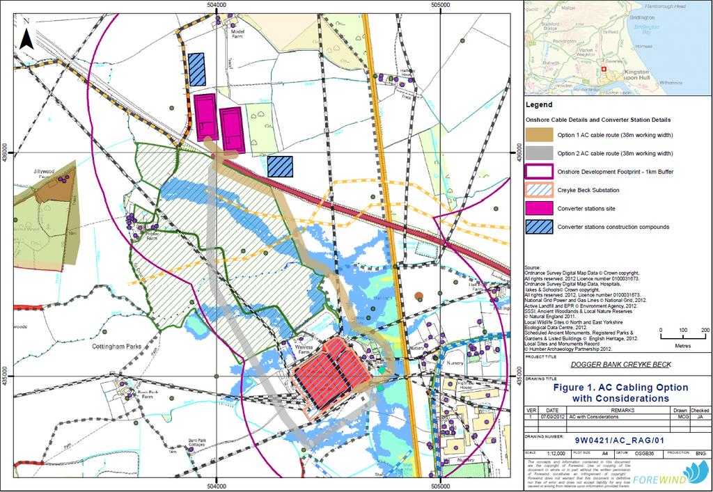
35 Setting - Beverley Minster 35
36 Traffic and Transport Site Selection Work Construction Access Agreed with ERYC Direct access off the A1079 at existing layby, left in and left out arrangement Health and safety considerations - Temporary Order to close the layby, gated access to remain shut during the operational phase Operational Access Access off A1079 not suitable Route off Long Lane down PRoW agreed in principle with ERYC on basis of 10 vehicle movements per day Detailed proposal by Forewind to be submitted to ERYC for agreement HVAC Route Construction Access Options to be assessed in group feedback session 36
37 Traffic Impact Assessment Principles Assessment will use the realistic worst case based on peak traffic generation e.g. period during construction when maximum activities are occurring at the same time along the cable route and converter stations. Modelling is currently underway Construction Total Project Construction Traffic Flows in Month 5 over 200 vehicles per day /over 400 twoway traffic movements) Approximately 60% of these are HGVs Proportion associated with converter station and HVAC is a lot lower e.g. 22 HGVs per day during Month 5 for converter construction. Operation Converter station un-manned Estimate 10 movements per day maintenance etc. 37
38 Public Rights of Way The Beverley 20 shares a 1km stretch of public bridleway which will be an operational access route to the converter stations Should any upgrades need to be made, the material used on the surface will be unbound so that the track is suitable for horses. 38
39 Noise A buffer zone of 2 km around the converter station site has been established for background noise monitoring Monitoring now complete Included in the calculations are: Operational noise from the converter stations Operational noise from the substation Construction related noise/vibration Off-site construction traffic noise Forewind will liaise with East Riding of Yorkshire Council to ensure that noise thresholds are agreed at the nearest properties. 39

40 Background Noise Monitor Locations 40
41 Noise Mitigation Best practice guidance will be followed during construction and operation, including: Construction - Well maintained vehicles - Machinery switched off when not in use - Silent generators for night time should security or lighting be required - Effective communication with locals, including information on works timings and potential night time works - Provision of site representative contact details, complaints can be dealt with directly Operation (converter stations) - Selection of quieter equipment - Installation of acoustic enclosures - Installation of acoustic barriers 41
42 AC Cable Corridor John Hughes 42
43 AC Cable Route Update This follows the information sent as part of the AC cable route update and outlines the development considerations identified for the two routes The micro-siting of the AC route has been influenced by the site selection work and proposed locations of the converter stations. Two options considered: Option 1 Eastern Route heads southeast from the A1079 road and arcs round to the east of the existing Creyke Beck substation before connecting to the south-east corner of the substation. Option 2 Western Route heads south from the A1079 road, passing across farmland before bearing east and passing to the south of the Creyke Beck substation, and connecting to the southeast corner of the substation. 43
44 44
45 Route Options Option 1 Eastern Route Option 2 Western Route Archaeology Ecology Existing Infrastructure Truncated barrow remains, easily avoidable Small number of hedgerows and watercourses to cross 2 gas pipelines, passes under some overhead lines Iron Age settlement site, must be avoided Poplar Farm Environmental Stewardship Scheme area, small number of hedgerows and watercourses 2 gas pipelines, passes under some overhead lines Residential Amenity 3 properties within 100m 1 property within 200m Public Rights of Way 1 footpath crossing 1 bridleway crossing Traffic and Transport 1 minor road crossing 1 minor road which is access route to Creyke Beck substation and Wanless Farm caravan storage 45
46 Preferred Option Option 1 is Forewind s preferred route To date, feedback from the working group has favoured Option 1 Any additional feedback? Option 1 - limits potential impact on an archaeological area of importance - avoids Poplar Farm Environmental Stewardship Scheme - avoids the use of Park Lane, an operational access road for the National Grid Substation and to the caravan storage business at Wanless Farm. The key risk with Option 1 is potential impacts on residential properties at Lawn Farm during construction Impacts will be temporary in nature, and where appropriate, mitigation measures will be identified - Due to the cables being laid underground, the potential flood risk of both options is low. 46
47 AC Cable route Temporary Construction Access Options Group feedback exercise 47

48 Temporary Access Options 48
49 Temporary Access Options Option 1 - Construction of a new, temporary road between the Beverley 20 PRoW and AC cable route - surveys must be undertaken in order to understand the full impact of this - Covers the length of the AC cable route - Impacts on a small section of Beverley 20 PRoW. Option 2 - Utilises existing private road via Poplar Farm which may or may not require upgrading - Disturbance of Poplar Farm Environmental Stewardship Scheme area - Close proximity to Poplar Farm and Wanlass residences - Impacts on Beverley 20 PRoW and National Cycle Network Route. Option 3 - Utilises agreed converter station operational access route - Joins option 1 or 2 south of A Proximity to Model Farm - Impacts on a greater length of the Beverley 20 PRoW Option 4 Passes through Cottingham village centre, additional traffic generation Same operational access as National Grid, possible conflict Impacts on National Cycle Network Route Proximity to Burn Park Cottages and Wanless residences. 49
50 Group exercise Group 1 Group 2 Group 3 Group 4 Forewind John Hughes Forewind Nikki Smith Forewind Jon Allen Forewind Rebecca Sherwood/Sam Oxley Cllr Kevin Casson Cottingham Parish Council Cllr Stephen McCloud Rowley Parish Council Cllr Peter Roustaby Skidby Parish Council Cllr Kerri Harold Woodmansey Parish Council Neville Jones CPRE East Yorkshire Gordon Scaife Cottingham Wild Spaces Group James Taylor Beverley Local Nature Reserve Doug Jennings Cottingham Civic Society Cllr Dominic Peacock ERYC Minster and Woodmansey Ward Cllr Tony Galbraith ERYC Dale Ward Cllr Ros Jump ERYC Cottingham North Ward Helen Reynolds Joint Hull and East Riding Local Access Forum Scott Royal - National Grid Steve George Beverley Minster Ian Booth St Mary s Church Rod Mackey East Riding Archaeology Society 50
51 AC Cable Corridor - Construction Access 1. Does the Working Group have any immediate thoughts on these routing options? 2. Are there any factors that we should consider which have not been mentioned in the options suggested? 3. Is there a clear preference from the options suggested? 51
52 Questions and Answers 52
53 Chair s closing remarks Cllr Jump 53
54 Thank you 54
BREEDON NORTHERN LIMITED
 Non Technical Summary CONTENTS 1 INTRODUCTION... 1 2 SITE DESCRIPTION... 1 3 DESCRIPTION OF THE DEVELOPMENT... 6 4 NEED FOR THE DEVELOPMENT... 8 5 KEY ISSUES CONSIDERED IN THE ENVIRONMENTAL IMPACT ASSESSMENT...
Replacement Golf Course Facilities and Residential Development, Churston. Environmental Statement Non-Technical Summary
 Replacement Golf Course Facilities and Residential Development, Churston Environmental Statement Non-Technical Summary July 2011 Reproduced from the Ordnance Survey s map with the permission of the Controller
Grantham Southern Quadrant Link Road Environmental Statement
 Grantham Southern Quadrant Link Road Environmental Statement Non Technical Summary Introduction Lincolnshire County Council (LCC) is submitting a planning application for the proposed implementation of
Rannoch 132 / 33 kv Substation Extension
 Who we are Scottish and Southern Energy Power Distribution is part of the SSE plc group of companies. We own, maintain and invest in the networks in the north of Scotland the electricity transmission network
Welcome to the Public Consultation Exhibition
 Welcome to the Public Consultation Exhibition Today is your opportunity to: Speak to the team Learn more about the project Leave feedback on the plans The Secretary of State for Transport has recognised
WHITELEY TOWN COUNCIL NORTH WHITELEY DEVELOPMENT SEPTEMBER 2014
 WHITELEY TOWN COUNCIL NORTH WHITELEY DEVELOPMENT SEPTEMBER 2014 Dear Resident This Special Edition of the Whiteley Voice which has been prepared in conjunction with the North Whiteley Consortium is to
University Park, Worcester Non Technical Summary December 2011
 University Park, Worcester Non Technical Summary December 2011 Introduction UW Wrenbridge LLP, a Joint Venture Company of the University of Worcester and Wrenbridge Land Ltd (the Applicants ) intend to
Wyvern Park Skipton Environmental Statement. Non-technical Summary - April 2015
 Wyvern Park Skipton Environmental Statement Non-technical Summary - April 2015 BWB Consulting Ltd Whitehall Waterfront 2 Riverside Way Leeds LS1 4EH Telephone: +44(0)113 233 8000 Copyright This Report
WELCOME. Welcome and thank you for visiting today.
 WELCOME Welcome and thank you for visiting today. Bellway Homes Ltd (Yorkshire) are preparing a reserved matters planning application for a residential development of 293 homes at land North of Yew Tree
Lower Hollow Copse. Questions and Answers on Proposals for Permanent Gypsy and Traveller Accommodation
 Lower Hollow Copse Questions and Answers on Proposals for Permanent Gypsy and Traveller Accommodation 0 Why does Mid Sussex District Council need to provide permanent gypsy and traveller accommodation?
NON-TECHNICAL SUMMARY
 Proposed Sand and Gravel Extraction and Associated Processing Operations with Restoration to a Mixture of Agriculture and Nature Conservation including Areas of Shallow Water at Hedgeley, Northumberland
Statement of Community Involvement LAND OFF SOUTHDOWN ROAD HORNDEAN, HAMPSHIRE
 LAND OFF SOUTHDOWN ROAD HORNDEAN, HAMPSHIRE CONTENTS Page 1. Introduction 3 2. Pre-application Discussions 4 3. The Consultation Process 5 4. Consultation Feedback 7 5. Responses to Consultation Feedback
Town and Country Planning (Environmental Impact Assessment Regulations) 2011 SCOPING OPINION
 2011 SCOPING OPINION") Town and Country Planning (Environmental Impact Assessment Regulations) 2011 SCOPING OPINION Application Site and Description of Development Proposed new quarry at Culham, Oxfordshire Land and Mineral
Town and Country Planning (Environmental Impact Assessment Regulations) 2011 SCOPING OPINION Application Site and Description of Development Proposed new quarry at Culham, Oxfordshire Land and Mineral
Land at Rampton Road. Cottenham
 Land at Rampton Road Cottenham Introduction TEP is preparing an outline planning application for 54 dwellings on 6.9 hectares of land adjacent to Rampton Road, Cottenham on behalf of the owners Cambridgeshire
ALLERTHORPE NEIGHBOURHOOD PLAN
 Allerthorpe s Neighbourhood Plan sets out a vision for the Parish for the next 15 years (2018 2033) that builds on and reflects the opinions and views of parish residents. VISION In 2033 Allerthorpe will
Welcome to our Public Consultation
 About our development This exhibition gives you the chance to view and comment on our emerging plans for a proposed residential development located on land to the West of Alwyn Road, Rugby. Welcome to
ABOUT CALA HOMES CALA HOMES
 WELCOME Welcome to this public consultation event for our proposed development on land to the east of Salisbury Road, in Hungerford. Thank you for taking the time to come along today. Homes and Wates Developments
The Place Solar Farm
 The Place Solar Farm Environmental Statement Non-Technical Summary 28 August 2014 Produced for Prepared by St John s House Queen Street, Manchester M2 5JB Contents Contents... 2 1 Introduction... 3 1.1
CENTRAL BEDFORDSHIRE COMMITTED TO WORKING TOGETHER WITH LOCAL COMMUNITIES
 WELCOME Thank you for coming to our consultation event to find out more about our emerging proposals for Hayfield Park, a residential development jointly promoted by the Hayfield Consortium: Martin Grant
Looking Forward. Tuesday 22 nd April 2018
 Looking Forward Tuesday 22 nd April 2018 Vernon Loo Community Engagement Manager Area Central Online HS2 has partnered with Commonplace to provide a locally focused website. This is currently being updated
Thornton Road, Pickering Environmental Statement Non-Technical Summary. January 2016
 Thornton Road, Pickering Environmental Statement Non-Technical Summary January 2016 EIA Quality This Environmental Statement, and the Environmental Impact Assessment (EIA) carried out to identify the significant
CALA Homes is preparing a planning application for a development of up to 36 new homes, including a mix of properties to meet local demand.
 WELCOME Welcome to this public consultation event for our proposed development on land to the south of Twelve Leys in Wingrave. Thank you for taking the time to come along today. Homes is preparing a planning
INTRODUCTION. Welcome to the third round of information events on the emerging Yorkshire Energy Park proposals. THE CONSULTANT TEAM WHERE IS THE SITE?
 1 INTRODUCTION Welcome to the third round of information events on the emerging Yorkshire Energy Park proposals. This is the third round of information events that we have undertaken on the project, following
UTT/17/2075/FUL - (BERDEN) (Referred to Committee by Councillor Janice Loughlin. Reason: In the Public Interest)
 (Referred to Committee by Councillor Janice Loughlin. Reason: In the Public Interest)") UTT/17/2075/FUL - (BERDEN) (Referred to Committee by Councillor Janice Loughlin. Reason: In the Public Interest) PROPOSAL: LOCATION: APPLICANT: Amendments to the design of a scheme for a 49.99MW battery
UTT/17/2075/FUL - (BERDEN) (Referred to Committee by Councillor Janice Loughlin. Reason: In the Public Interest) PROPOSAL: LOCATION: APPLICANT: Amendments to the design of a scheme for a 49.99MW battery
Welcome. Land adjacent Sandy Lane WALTHAM CHASE THE PROPOSED SITE
 Land adjacent Sandy Lane WALTHAM CHASE Existing Linden Homes developments Welcome Welcome to Linden Homes Southern s ( Linden ) public exhibition about its proposals for a range of high-quality homes for
Barvills Solar Farm Environmental Statement Non-Technical Summary
 Barvills Solar Farm Environmental Statement Non-Technical Summary 13 March 2015 Produced for Prepared by St John s House Queen Street, Manchester M2 5JB Contents Contents... 2 1 Introduction... 3 1.1 Development
Mapping produced by the Bedfordshire and Luton Biodiversity Recording and Monitoring Centre
 Mapping produced by the Bedfordshire and Luton Biodiversity Recording and Monitoring Centre Chalton Parish Green Infrastructure Plan Methodology In April 2007 Chalton Parish Council were approached with
DEFGH. Crystal Place Park. Environmental Impact Assessment (EIA) Elin Thomas and Emily Low Waterman Environmental
 Elin Thomas and Emily Low Waterman Environmental") DEFGH Crystal Place Park Environmental Impact Assessment (EIA) Elin Thomas and Emily Low Waterman Environmental 10.12.07 EIA Presentation Content What is EIA? Legal Requirements Process Q&A Key Topics
DEFGH Crystal Place Park Environmental Impact Assessment (EIA) Elin Thomas and Emily Low Waterman Environmental 10.12.07 EIA Presentation Content What is EIA? Legal Requirements Process Q&A Key Topics
LAND AT WEST YELLAND. Environmental Statement Non-Technical Summary Welbeck Strategic Land LLP
 LAND AT WEST YELLAND Environmental Statement Non-Technical Summary Welbeck Strategic Land LLP May 2014 Quality Management Issue/revision Issue 1 Revision 1 Revision 2 Revision 3 Remarks Draft FINAL Date
The Site. Welcome to the public exhibition for Boothferry Road, Hessle.
 LINDEN HOMES Welcome to the public exhibition for Boothferry Road, Hessle. We would like to hear your views about our proposals before we submit a planning application later this year. If there is anything
Route Alignment Options Summary Report
 Brechfa Forest Connection Project February 2014 Summary report 1. RSK Environment Ltd (RSK) was commissioned by Western Power Distribution (WPD) to provide environmental consultancy support services for
Welcome to our exhibition
 Welcome to our exhibition housing development A46 Wildmoor Alcester Road Canal Quarter A422 Town Centre housing development Warwickshire-based IM Properties, one of the UK s largest privately owned property
Urban Growth Boundaries
 Urban Growth Boundaries Discussion Document July 2008 Contents page Introduction... 3 What are urban growth boundaries?... 3 The need to manage growth... 3 Purpose of urban growth boundaries... 4 How will
DINBVfZGH THE CITY OF EDINBURGH COUNCIL
 DINBVfZGH THE CITY OF EDINBURGH COUNCIL Item 6 Development Management Sub-Committee 24 November 2010 Report by the Head of Planning by Scottish Water for Residential Development at Land at 55 Buckstone
Welcome to our public exhibition
 About our scheme Welcome to our public exhibition Taylor Wimpey East Anglia intends to submit a detailed planning application for a new residential development of 39 high-quality homes at the B&M Concrete
Wind energy development in the South Pennines landscape
 Wind energy development in the South Pennines landscape Programme for today Background Policy context South Pennines landscape Impacts of wind energy development The South Pennines Wind Energy Landscape
Kibworth Harcourt. Introduction. Introduction
 Introduction Introduction Welcome to this public exhibition on the proposals for the delivery of new homes on land at The Kibworths. The purpose of today s exhibition is to give you the opportunity to
Comments on the proposed scope are requested from WCC/NBBC officers to be provided to SLC Rail by 25 th March 2016 and sent to
 Introduction WCC have indicated that in advance of the surveys and assessments being undertaken consultation should be undertaken with technical officers of both Warwickshire CC and Nuneaton and Bedworth
Welcome to our public exhibition
 About Our Scheme Welcome to our public exhibition This exhibition gives you the chance to view and comment upon our emerging proposals for a new residential development of 68 new homes on the site of the
WELCOME. Land North of STEVENAGE. We would like to thank you for attending our public exhibition today.
 WELCOME We would like to thank you for attending our public exhibition today. The purpose of this event is to share our proposals and hear your thoughts on our ideas. Members of the project team are on
Linden Homes Proposals for land off Ringwood Road, Verwood
 Welcome Welcome to Linden Homes first public exhibition displaying proposals for new homes on land off Ringwood Road in Verwood. Award-winning house builder Linden Homes, part of the Galliford Try Group,
Thank you for sparing the time to visit our exhibition and to provide us with your feedback on our proposals displayed here today.
 WELCOME Aerial image of the application site in context Thank you for sparing the time to visit our exhibition and to provide us with your feedback on our proposals displayed here today. Plymouth City
Introduction. Who we are. Purpose of this public consultation
 Introduction Who we are Purpose of this public consultation SHE Transmission are proposing to submit a planning application for our proposed Development of a High Voltage Direct Current Switching Station
Development of land adjacent to Braggs Farm Lane and Rumbush Lane, Dickens Heath. Welcome. Today s exhibition. The proposal site
 Welcome Welcome to this event to discuss the development of land adjacent to Braggs Farm Lane. is currently in the preliminary stages of designing proposals to sensitively develop this site with high-quality
Caithness HVDC Switching Station Pre Application Consultation Event. August 2016
 Caithness HVDC Switching Station Pre Application Consultation Event August 2016 Introduction Who we are Purpose of this public consultation Other SSE Businesses SHE Transmission are proposing to submit
NON-TECHNICAL SUMMARY
 Hybrid outline/detailed planning application comprising an outline planning application for 196 residential dwellings, landscaping, open space, estate roads and infrastructure, plus 4 permanent gypsy and
INTRODUCTION NORTH HEYBRIDGE GARDEN SUBURB
 INTRODUCTION This event is being hosted by the promoters of the proposed North Heybridge Garden Suburb who are working with Maldon District Council and other key stakeholders on the preparation of a comprehensive
LAND NORTH OF NETHERHOUSE COPSE, FLEET
 REPORT N O 70020067 LAND NORTH OF NETHERHOUSE COPSE, FLEET ENVIRONMENTAL STATEMENT VOLUME 3:NON-TECHNICAL SUMMARY OF THE ENVIRONMENTAL STATEMENT PUBLIC JUNE 2016 LAND NORTH OF NETHERHOUSE COPSE, FLEET
HUNGERFORD SOLAR FARM
 HUNGERFORD SOLAR FARM Key Facts The site comprises approximately 26 acres/10.6 hectares of Grade 3 and 4 agricultural land, currently in arable use. It will have a generation capacity of approximately
Welcome to our public exhibition
 About our development Welcome to our public exhibition This exhibition gives you the chance to view and comment on our proposals for a new residential development of 165 high-quality homes, along with
WELCOME GYPSY LANE. Wider Site Location plan. Proposals for the development of LAND OFF FOXLYDIATE LANE WEBHEATH. Proposals for the development of
 WELCOME The developers are preparing an outline planning application for a residential led development and need the community s views in order to develop the proposals further WHAT IS PROPOSED? A high
List of Policies. SESPlan. None applicable. Consolidated Scottish Borders Local Plan 2011: POLICY G1 - QUALITY STANDARDS FOR NEW DEVELOPMENT
 List of Policies Local Review Reference: 15/00021/RREF Planning Application Reference: 15/00616/FUL Development Proposal: Installation of 16no solar photovoltaic (PV) panels to roof Location: Raebank,
Development of Land at Thorp Arch Estate, Wetherby. Environmental Statement Non-Technical Summary July 2013
 Development of Land at Thorp Arch Estate, Environmental Statement July 2013 Contents 1. Introduction... 3 1.1 Background... 3 1.2 Environmental Assessment... 3 1.3 Site Description... 4 2. The Proposals...
8.0 Design and Form of Development 43/
 42/ 8.0 Design and Form of Development 43/ Rothwells Farm, Golborne/ Development Statement Figure 7. Site Constraints Key 44/ Site Boundary 360 Bus Route/Stops Existing Trees Underground Water Pipe Sensitive
LONGDEN VILLAGE DEVELOPMENT STATEMENT
 LONGDEN VILLAGE DEVELOPMENT STATEMENT 2017-2027 1 Longden Development Statement 2017-2027 15/01/18 1. Background 1.1 Longden Village Longden village is a very rural and traditional community first mentioned
Contents. Annexes. Annex 1 Process Diagram for the discharge of the DCO Requirements. Annex 2 Design Sheet Power Generation Plant
 Design Principles Document December 2014 Contents Summary... 2 Purpose of this Statement... 2 Design Parameters... 2 Guidance Documents... 3 Additional Design Considerations... 3 Public involvement and
Dorenell Wind Farm 132 kv Grid Connection
 Who We Are Scottish and Southern Energy Power Distribution is part of the SSE plc group of companies. We own, maintain and invest in the electricity networks in the north of Scotland the electricity transmission
INTRODUCTION. Land West of Main Road, Stanton Harcourt THE SITE. Why is the Site Suitable for Development?
 0 INTRODUCTION THE SITE Application Boundary Gladman Developments Ltd has successfully invested in communities throughout the UK over the past 0 years, developing high quality and sustainable residential,
SEABANK 3. Interim Landscape and Design Statement
 SEABANK 3 Interim Landscape and Design Statement Prepared for: SSE plc URS Infrastructure & Environment UK Limited. Scott House Alencon Link Basingstoke Hampshire RG21 7PP UK 1 TABLE OF CONTENTS 1 INTRODUCTION...
Welcome. Site/11/04. Site/11/03. Proposed Site. 11,400 new homes needed in east Cambs
 Welcome Welcome to our consultation on our proposals for new homes on land north east of Soham Road, Fordham. Members of the project team are available to answer any questions you have and listen to feedback.
Longhorsley Neighbourhood Plan
 Site Assessment 1. The availability of the site 1.1 Is the land owner willing for their site to be made available for development? 1.2 If yes, do you have any written evidence to back this up? Planning
Public Consultation. Land at Monks Farm, North Grove. Welcome
 Welcome Welcome to our public exhibition for development on Land at Monks Farm, orth Grove. Gallagher Estates and Gleeson Strategic Land are preparing an outline planning application for new homes, open
Who Is Parkside Regeneration?
 Who Is Parkside Regeneration? Parkside Regeneration is a joint venture between commercial developers Langtree and St Helens Council. Langtree is a commercial property company, active in property management,
WELCOME LAND EAST OF TYE LANE, WALBERTON. Above all, it s about people
 WELCOME Welcome to this public exhibition relating to our draft residential proposals for the land east of Tye Lane, Walberton. Today gives you the opportunity to have an active role in shaping these ideas
Copyright Nigel Deeley and licensed for reuse under this Creative Commons Licence
 1 Copyright Nigel Deeley and licensed for reuse under this Creative Commons Licence Prepared by the Neighbourhood Plan Steering Group on behalf of Garway Parish Council with assistance from 2 Table of
Planning and Sustainability Statement
 Land adjacent to Manor Farm, Catterick Village Pallett Hill Sand and Gravel Co Ltd Proposed 10 new dwellings, (6 No market dwellings and 4 No affordable dwellings) with access, associated car parking and
Slough International Freight Exchange Proposals, Colnbrook+
 Welcome Welcome to this exhibition, which is being held in connection with our proposals for a new freight exchange facility on land to the north of the A4. Please take this opportunity to look at the
ROCHFORD LOCAL DEVELOPMENT FRAMEWORK: Sustainability Appraisal/ Strategic Environmental Assessment. Rochford Core Strategy Preferred Options Document
 ROCHFORD LOCAL DEVELOPMENT FRAMEWORK: Sustainability Appraisal/ Strategic Environmental Assessment Non Technical Summary Rochford Core Strategy Preferred Options Document October 2008 SUSTAINABILITY APPRAISAL
1. Local Plan Context
 1. Local Plan Context WHY ARE YOU HERE? ABOUT US PLANNING APPLICATION CONSULTATION Stewart Milne Homes are in the process of preparing a detailed planning application for a development of approximately
Thank you for coming. We want to hear your views on proposed improvements to the A1 between junction 65 (Birtley) and junction 67 (Coal House).
 and junction 67 (Coal House).") Welcome Thank you for coming. We want to hear your views on proposed improvements to the between junction 65 (Birtley) and junction 67 (Coal House). This is your opportunity to provide comments on our
Welcome Thank you for coming. We want to hear your views on proposed improvements to the between junction 65 (Birtley) and junction 67 (Coal House). This is your opportunity to provide comments on our
Environmental Impact Assessment
 Environmental Impact Assessment Environmental impact assessment (EIA) is the process of systematically drawing together an assessment of the likely significant environmental effects of a development project.
Carterton Construction Ltd is bringing forward plans for up to 85 new family homes and extra care facilities on land east of Burford.
 Welcome Carterton Construction Ltd is bringing forward plans for up to 85 new family homes and extra care facilities on land east of. We are at the early stages of designing our proposals and have a number
Departure from the Development Plan. Town Council objection to a major application. DETERMINE
 Item No. 9 APPLICATION NUMBER CB/17/01642/OUT LOCATION Land rear of 43 to 91 Silver Birch Avenue South of Alder Green and Aspen Gardens, Aspen Gardens, Stotfold PROPOSAL Outline application for up to 95
7. The Landscape. 7.1 Introduction. Environmental Impact Statement (EIS) Scoping Report
 Scoping Report") 7. The Landscape 7.1 Introduction The purpose of this section of the EIS Scoping Report is to describe the scope of work and methods to be applied in the identification and assessment of landscape and
7. The Landscape 7.1 Introduction The purpose of this section of the EIS Scoping Report is to describe the scope of work and methods to be applied in the identification and assessment of landscape and
Test Valley Borough Council Southern Area Planning Committee 8 January 2019
 ITEM 11 APPLICATION NO. 18/02218/FULLS APPLICATION TYPE FULL APPLICATION - SOUTH REGISTERED 23.08.2018 APPLICANT Rugby Football Union SITE The Trojans Club, Stoneham Lane, Eastleigh, SO50 9HT, CHILWORTH
SOUTH CAMBRIDGESHIRE DISTRICT COUNCIL. Planning and New Communities Director
 SOUTH CAMBRIDGESHIRE DISTRICT COUNCIL REPORT TO: Planning Committee 9 January 2013 AUTHOR/S: Planning and New Communities Director S/2270/12/FL FEN DRAYTON 850m long flood defence embankment ranging in
9 Archaeology & Cultural Heritage
 High Clachaig Wind Farm Scoping Report Page 56 9 Archaeology & Cultural Heritage 9.1 Introduction Cultural heritage in this context means the above- and below-ground archaeological resources, built heritage,
Newcourt Masterplan. November Exeter Local Development Framework
 Newcourt Masterplan November 2010 Exeter Local Development Framework Background The Exeter Core Strategy Proposed Submission sets out the vision, objectives and strategy for the development of Exeter up
Bloor Homes Stubbocks Walk North Hertfordshire ENVIRONMENTAL STATEMENT NON-TECHNICAL SUMMARY
 Bloor Homes Stubbocks Walk North Hertfordshire ENVIRONMENTAL STATEMENT NON-TECHNICAL SUMMARY December 2016 Environmental Statement: Non-Technical Summary Stubbocks Walk, North Hertfordshire J S Bloor
Linden Homes Land at Hill Place Farm, East Grinstead
 Welcome Welcome to Linden Homes public exhibition displaying proposals for the development of land at Hill Place Farm, East Grinstead Linden Homes has an interest in this land and is currently developing
South Whitehaven, Cumbria EIA
 South Whitehaven, Cumbria EIA Environmental Statement - Non Technical Summary June 2013 in association with 1. Introduction Story Homes is applying to Copeland Borough Council (CBC) for a new residential
Rempstone Extension - East Leake 2014
 Overall Restoration of East Leake Quarry Sand Martin Face Southern Agricultural Corridor Wetland Ponds/Conservation Corridor following Sheepwash Brook Reinstated Bridleway/Footpaths Southern Agricultural
NORTHAMPTON. Overstone Leys. Delivering a New Sustainable Urban Extension for Northampton. Progress Report March 2013
 Overstone Leys NORTHAMPTON Delivering a New Sustainable Urban Extension for Northampton Progress Report March 2013 Prepared by Pegasus Group Barratt Developments 18.03.13 EMS.2089 _27 A Contents 1. Background
About 10% of the Borough's population lives in the seven rural parishes. Population figures from the 1991 census are given below:-
 8. THE DISTRICT VILLAGES 8.1 Population About 10% of the Borough's population lives in the seven rural parishes. Population figures from the 1991 census are given below:- Village No. of Persons Cottingham
LAND AT HOWES LANE, BICESTER ENVIRONMENTAL STATEMENT NON-TECHNICAL SUMMARY. March 2017 Our Ref: Q70433
 LAND AT HOWES LANE, BICESTER ENVIRONMENTAL STATEMENT NON-TECHNICAL SUMMARY March 2017 Our Ref: Q70433 Contents 1 INTRODUCTION AND SITE DESCRIPTION... 1 2 EIA METHODOLOGY... 5 3 ALTERNATIVES... 6 4 DESCRIPTION
M4 Corridor around Newport Environmental Statement Volume 3: Appendices
 Environmental Statement Volume 3: Appendices Environmental Statement Volume 3: Appendices At Issue March 2016 CVJV/AAR 3 rd Floor Longross Court, 47 Newport Road, Cardiff CF24 0AD Volume 3: Contents 1
Section 12C Subdivision in the Rural Residential Zone
 Section 12C 12C Subdivision in the Rural Residential Zone The Rural Residential Zone provides part of the range of residential opportunities within the City. Land zoned rural residential is considered
EAST OF ENGLAND OFFICE
 Mr Philip Isbell Direct Dial: 01223 582751 Mid Suffolk District Council 131 high Street Our ref: P00524468 Needham Market Ipswich Suffolk IP6 8DL 18 January 2017 Dear Mr Isbell T&CP (Development Management
Green Infrastructure planning must be evidence led, thus the importance of this stage in collating your information and responses.
 Green Infrastructure Consultation Proforma Recipients: Andy Maginnis (Countryside Services) regarding access, recreation and tourism Ed Dursley (Transport) regarding access and movement Steve Bloomfield
Viewpoint 1. Location: View from Murch Road on the north eastern boundary of Application Site. Viewing south / southwest.
 Application Site (eastern field) Former site of St. Cyres Lower School Murch Road 1 Location: View from Murch Road on the north eastern boundary of Application Site. Viewing south / southwest. Baseline
Dear Ms Blewett. By to: Longmore House Salisbury Place Edinburgh EH9 1SH
 By email to: Jo.Blewett@transport.gov.uk Ms Jo Blewett A9 Dualling Team Transport Scotland Buchanan House 58 Port Dundas Road Glasgow G4 0HF Longmore House Salisbury Place Edinburgh EH9 1SH Adele.Shaw@hes.scot
16 LANDSCAPE AND VISUAL IMPACT
 16 LANDSCAPE AND VISUAL IMPACT 16.1 Introduction The term landscape refers primarily to the visual appearance of an area, including its shape, form and colour and the interaction of these elements to create
INTRODUCTION. Land south of Bishopswood Lane, Tadley
 0 INTRODUCTION THE SITE Introduction Gladman Developments Ltd. has successfully invested in communities throughout the UK over the past 0 years, developing high quality and sustainable residential, commercial
2.4 Site Photographs. 4 View of Listed Building looking East. 3 View looking north west of the field adjacent to the site from existing hard standing
 Looking north on to from the junction to 2 View towards the entrance of from 3 View of southern access to site from Riddles Road 4 3 2 4 Looking west on to from southern access to site View of Grade II
Local Development Scheme
 Local Development Scheme 2012 2016 The Local Development Scheme (LDS) is a project plan that outlines how and when the Authority will update its planning policies and other associated documents. It ensures
Warwickshire County Council. Upper and Lower Brailes. Landscape Study
 Warwickshire County Council Upper and Lower Brailes Landscape Study Produced by WCC Landscape Architects March 2016 Landscape Assessment of Potential Development Sites within the parish of Brailes 1.0
SOUTH CAMBRIDGESHIRE DISTRICT COUNCIL. REPORT TO: Planning Committee 1 April 2015 Planning and New Communities Director
 SOUTH CAMBRIDGESHIRE DISTRICT COUNCIL REPORT TO: Planning Committee 1 April 2015 AUTHOR/S: Planning and New Communities Director Application Number: Parish(es): Proposal: Site address: Applicant(s): Recommendation:
PANSHANGER QUARRY, Hertfordshire
 PANSHANGER QUARRY, Hertfordshire Proposed enhanced restoration of Phases F & H Briefing Note 1 March 2015 INERT (INACTIVE) RESTORATION MATERIALS, CONTROLS AND OPERATIONS 1 Introduction This briefing note
Wildlife and Planning Guidance: Neighbourhood Plans
 Wildlife and Planning Guidance: Neighbourhood Plans This Leaflet is one of a series of 4 Wildlife and Planning Guidance Leaflets and is intended to provide useful information to assist you to campaign
PROPOSED RESIDENTIAL DEVELOPMENT ON LAND SOUTH OF SUTTON ROAD, LANGLEY, MAIDSTONE
 Land at PROPOSED RESIDENTIAL DEVELOPMENT ON LAND SOUTH OF SUTTON ROAD, LANGLEY, MAIDSTONE Environmental Statement: Non-Technical Summary October 2015 Introduction Countryside Properties Ltd is applying