ACCESS MANAGEMENT REPORT U.S S.H. 1 TO S.H. 14 S.H U.S. 287 TO I-25
|
|
|
- Chastity Cooper
- 5 years ago
- Views:
Transcription
1
2 ACCESS MANAGEMENT REPORT U.S S.H. 1 TO S.H. 14 S.H U.S. 287 TO I-25 Prepared by: City of Fort Collins Transportation Planning 7951 East Maplewood Avenue, Suite E. Olive, P.O. Box 580 Englewood, CO Fort Collins, CO Project Manager: Richard R. Follmer, P.E. Project Manager: Kathleen Reavis Larimer County Balloffet & Associates, Inc. 218 West Mountain Avenue 345 E. Mountain Avenue P.O. Box 1190 Fort Collins, CO Fort Collins, CO Project Manager: Ray A. Moe Project Manager: Marc Engemoen, P.E. Colorado Department of Transportation Albertson Clark Associates Region Fairway Six Drive nd Street Fort Collins, CO Greeley, CO Project Manager: Sherry Albertson-Clark Access Manager: Tess M. Jones FHU Reference No April 4, 2000
3 TABLE OF CONTENTS EXECUTIVE SUMMARY... i 1.0 INTRODUCTION Project Background Project Coordination Public Involvement Report Format ACCESS OBJECTIVES, PRINCIPLES AND STRATEGIES Project Objectives Principles Access Issue Examples Strategies ACCESS CONTROL PLAN - US 287(NORTH COLLEGE AVENUE) Existing Conditions Inventory of Access Points Existing Traffic Conditions Projected Conditions Projected Traffic Conditions Access Control Plan Cost Estimates ACCESS CONTROL PLAN - SH 14 (JEFFERSON STREET/RIVERSIDE AVENUE) Existing Conditions Inventory of Access Points Existing Traffic Conditions Projected Conditions Projected Traffic Conditions Access Control Plan Cost Estimates ACCESS CONTROL PLAN - SH 14 (MULBERRY STREET) Existing Conditions Inventory of Access Points Existing Traffic Conditions Projected Conditions Projected Traffic Conditions Access Control Plan Cost Estimates IMPLEMENTATION
4 LIST OF APPENDICES APPENDIX A - Existing Access Points - North College Avenue APPENDIX B - Existing Access Points - Jefferson Street/Riverside Avenue APPENDIX C - Existing Access Points - Mulberry Street APPENDIX D - Public Outreach Summary APPENDIX E - Project Team Members APPENDIX F - Access Issue Photo-Log APPENDIX G - Accident History Diagrams APPENDIX H - City of Fort Collins Master Street Plan - Amended April 4, 2000
5 LIST OF FIGURES ES-1 Project Priority and Conceptual Opinion of Probable Costs - North College Avenue, Short-Term Access Plan... v ES-2 Project Priority and Conceptual Opinion of Probable Costs - North College Avenue, Long-Range Access Plan... vi ES-3 Project Priority and Conceptual Opinion of Probable Costs - Jefferson Street/Riverside Avenue Access Plan...viii ES-4 Project Priority and Conceptual Opinion of Probable Costs - Mulberry Street Access Plan... ix 1 Study Area Existing Typical North College Avenue Cross-Section Existing Traffic Volumes - North College Avenue - Jefferson Street to Conifer Street Existing Traffic Volumes - North College Avenue - Conifer Street to SH Existing Level of Service and Intersection Geometry - North College Avenue - Jefferson Street to Conifer Street Existing Level of Service and Intersection Geometry - North College Avenue - Conifer Street to SH Corridor Accidents by Severity North College Avenue Arterial Street Cross-Section Short-Term (Year 2005) Traffic Volume Projections and Level of Service - North College Avenue - Jefferson Street to Conifer Street Short-Term (Year 2005) Traffic Volume Projections and Level of Service - North College Avenue - Conifer Street to SH Long-Range (Year 2020) Traffic Volume Projections and Level of Service - North College Avenue - Jefferson Street to Conifer Street Long-Range (Year 2020) Traffic Volume Projections and Level of Service - North College Avenue - Conifer Street to SH Short-Term Access Control Plan - North College Avenue Short-Term Access Control Plan - North College Avenue Short-Term Access Control Plan - North College Avenue Short-Term Access Control Plan - North College Avenue Long-Range Access Control Plan - North College Avenue Long-Range Access Control Plan - North College Avenue Long-Range Access Control Plan - North College Avenue Long-Range Access Control Plan - North College Avenue Project Priority and Conceptual Opinion of Probable Costs - Short-Term Access Plan Project Priority and Conceptual Opinion of Probable Costs - Long-Range Access Plan Page
6 LIST OF FIGURES (Continued) 4-1 Existing Typical Jefferson Street Cross-Section Existing Typical Riverside Avenue Cross-Section Existing Traffic Volumes - Jefferson Street/Riverside Avenue Existing Levels of Service and Intersection Geometry - Jefferson Street/Riverside Avenue Corridor Accidents by Severity Proposed Jefferson Street Cross-Section Proposed Riverside Avenue Cross-Section Year 2020 Traffic Volume Projections and Level of Service - Jefferson Street/Riverside Avenue Access Control Plan - Jefferson Street Access Control Plan - Riverside Avenue Project Priority and Conceptual Opinion of Probable Costs - Jefferson Street/Riverside Avenue Access Plan Existing Typical Mulberry Street Cross-Section Existing Traffic Volumes - Mulberry Street - Riverside Avenue to Timberline Road Existing Traffic Volumes - Mulberry Street - Summit View Drive to I Existing Levels of Service and Intersection Geometry - Mulberry Street - Riverside Avenue to Timberline Road Existing Level of Services and Intersection Geometry - Mulberry Street - Summit View Drive to I Corridor Accidents by Severity Proposed Typical Mulberry Street Cross-Section Year 2020 Traffic Volume Projections and Levels of Service - Mulberry Street Riverside Avenue to Timberline Road Year 2020 Traffic Volume Projections and Levels of Service - Mulberry Street Summit View Drive to I Access Control Plan - Mulberry Street Access Control Plan- Mulberry Street Access Control Plan - Mulberry Street Access Control Plan - Mulberry Street Access Control Plan - Mulberry Street Access control Plan - Mulberry Street Project Priority and Conceptual Opinion of Probable Costs - Mulberry Street Page
7 LIST OF TABLES 3-1 Access Categories Corridor Accidents by Type (1/96-7/98) Accident Rate Comparison - North College Avenue versus Statewide Average Conceptual Opinion of Probable Costs By Section Conceptual Opinion of Probable Costs by Project - Short-Term Plan Conceptual Opinion of Probable Costs by Project - Long-Range Plan Access Categories Corridor Accidents by Type (1/96-7/98) Accident Rate Comparison - Jefferson Street and Riverside Avenue versus Statewide Average Conceptual Opinion of Probable Costs By Section Conceptual Opinion of Probable Costs by Project Access Categories Corridor Accidents by Type (1/96-7/98) Accident Rate Comparison - Mulberry Street versus Statewide Average Conceptual Opinion of Probable Costs By Section Conceptual Opinion of Probable Costs by Project... 98
8 EXECUTIVE SUMMARY Background and Purpose The City of Fort Collins, in concert with the Colorado Department of Transportation (CDOT) and Larimer County (County), is promoting the development of three Access Control Plans along two regional highways that are major arteries of the City and County street system. These two highways, United States Highway 287 (US 287) and State Highway 14 (SH 14), are two of the most important regional highways in northern Colorado, providing both north/south (US 287) and east/west (SH 14) access throughout the front range and eastern plains of Colorado. To the west of Interstate 25, and northward from the City of Fort Collins, the combination of these two routes provides an alternate for interstate traffic to the north into Wyoming. As such, these routes carry a wide range of vehicle and travel types: long-distance interstate traffic, semi-truck delivery vehicles within the Fort Collins city limits and Larimer County, tourist traffic between I-25 and Poudre Canyon, and commuter traffic to the employment bases in Fort Collins, Greeley, Loveland and the Denver metropolitan area. Development pressures within the study corridor will continue to increase the travel demand along these routes. Therefore, providing good mobility and a safe operating environment for all modes of transportation is essential. In 1995, the DRAFT Access Control Study of the US 287 and SH 14 Corridor study was prepared to develop an Access Control Plan along the same corridors. This study recommended access control measures that would also have met the objectives of this report; however, that report was not finalized and an Access Control Plan was not formally adopted. The purpose of the current planning effort was to work closely with residents, property and business owners and highway users to develop detailed, long-range Access Control Plans for the US 287 and SH 14 corridors. The Plan addresses how each access in each corridor should be treated, the cost for the recommended access modifications, and the relative priority of the improvements. The ultimate goal is to develop Access Control Plans which will be adopted as Intergovernmental Agreements by the City, CDOT and Larimer County. Study Area The study area extends along US 287 and SH 14 from SH 1 (just to the north of the Fort Collins city limit) to I-25. As such, the study area encompasses approximately 6¼ miles along these routes. The study is divided into three corridors and each corridor will have a separate Intergovernmental Agreement and Access Control Plan. Each corridor has a distinct character and is essentially urban in character. The North College Avenue (US 287) corridor serves a myriad of light industrial, retail and residential uses with numerous undefined access points. Along Jefferson Street (SH 14) and Riverside Avenue (SH 14), the character is more dense, with narrower lanes, parking and more driveway access. Along the eastern portion of the project (Mulberry Street, SH 14), commercial and residential land uses are served by a four-lane highway with a developed frontage road system. Page i
9 There are currently 331 public and private access points along these corridors. The access types have been classified as follows: Access Types Corridor Public Road Intersections with Signals Public Road Intersections without Signals Driveway Accesses Total Number of Accesses North College Avenue (1.76 Miles) Jefferson Street/ Riverside Avenue (0.97 Miles) Mulberry Street (3.29 Miles) Total Number of Accesses Includes public alley accesses. Includes accesses with the state highway and along the frontage roads. The accident history of each corridor reveals that 414 accidents occurred during the period from January of 1996 through July of Of these, percent (depending upon the corridor) were access related. Development of the Plan The physical and operational characteristics of US 287 and SH 14 are managed by the CDOT; however, these roadways also traverse the boundaries of two governmental agencies within the study limits, the City of Fort Collins and Larimer County. The City of Fort Collins, through the office of Transportation Planning, was the primary force behind the development of this project with direct input and cooperation with the CDOT. Larimer County was also involved in the Access Control Plan preparation along Mulberry Street since approximately 85 percent of the SH 14 alignment in this area is within unincorporated Larimer County, which is in the City of Fort Collins Urban Growth Area. The primary project team for development of the Access Control Plans was comprised of City and County staff, the access manager for the CDOT - Region 4, and representatives of three consultants. Plan progress was coordinated with other departments within the City, and with County and CDOT organizations. Public open house events and meetings with local business owners, property owners and residents were also conducted. Page ii
10 Public Involvement One of the most critical elements of this project was involvement with the public at open houses that were held at key stages of the study. For each corridor, a series of four open houses were conducted. The first meeting included a formal presentation that addressed the objectives of the access management efforts and provided information as to the plan process, access management principles and techniques, and how the project may be implemented. The second open house provided exhibits on the draft conceptual plans to obtain public input, while the third presented the revised plan. Comment sheets were used to record property and business owner concerns. Final plan revisions were presented at the last open house, organized for all of the corridors. Visual aids were used that included a video on access management prepared by the Federal Highway Administration. Exhibits showing historic accident data, existing and proposed traffic volumes, and existing and proposed access locations were available, with City, County, CDOT and consultant representatives in attendance to answer questions and to receive comments, concerns, and input. Mailing lists of adjacent property owners within 500 feet of each highway were maintained for the study, with each property owner and business being notified of each public meeting. Press releases were also used to inform the general public. City, County and CDOT staff also visited numerous sites along each corridor to talk individually with property owners, business owners and residents. These meetings were very informative since issues related to a specific access or property owner need could be addressed on a one-to-one basis. In addition to the public open houses and individual meetings, agency staff met with the North College Business Owners Association a total of four times during the study, while meetings with the Old Town (formerly East Side) Neighborhood Association and the Northeast Business Association were also conducted. These meetings provided good feedback from organized groups within the study corridors. Public involvement for this project resulted in business and property owners being actively involved in developing access solutions. This involvement represents a valuable piece of the project and has led to the development of Access Control Plans that are supported by the majority of business and property owners within each corridor with a high potential for success. Access Control Plans Figures ES-1 through ES-4 provide overviews of the major access improvements included in the Access Control Plans. Since implementation of the improvements will take many years, and since funding will likely come from a variety of different sources, a priority of Long-Range improvements was assigned to each plan within each corridor. Since it is difficult to define funding levels within specific time periods, the priorities were established on the basis of the greatest need as opposed to a likely time-frame for implementation. Further, for the Short-Term North College Avenue plan, a phasing scheme was used to prioritize improvements since the sequence of the improvements are more clearly defined at this time. Page iii
11 A few of the major projects along each corridor are listed below. Access management recommendations on Mulberry Street between Timberline Road and I-25 are from the I-25/SH 14 Interchange Area Study. An immediate need for access improvements was identified for North College Avenue and, therefore, both Short- Term and Long-Range Access Control Plans were developed for this corridor. Only long-range plans were developed by the project team for the Jefferson Street/Riverside Avenue and Mulberry Street corridors. Short-Term Access Management Plan - North College Avenue Improved definition of driveway access along the corridor by constructing frontage improvements. Raised median along a few segments of North College Avenue that is anticipated to reduce the accident potential in those areas. These locations include: 1) north of Willox Lane, 2) north of Cherry Street/Willow Street. Construct a second southbound left turn lane at Jefferson Street to increase vehicle storage capacity. As part of this improvement, modify the existing traffic signal to signalize the right turn movement from Jefferson Street onto northbound North College Avenue to eliminate weaving for northbound left turn movements at Cherry Street. Paving of a public alley to the east of North College Avenue between Bristlecone Drive and Conifer Street. This improvement will provide an alternative access for the businesses along North College Avenue from the back of their parcels. Long-Range Access Management Plan - North College Avenue Construct the City of Fort Collins Arterial Street section along the entire length of North College Avenue. Develop a parallel street system on both the east and west sides of North College Avenue. The construction of raised median along North College Avenue should coincide with the opening of parallel street segments. Re-construct the offset T intersections of Hickory and Conifer Streets to create one four-legged, signalized intersection. Extend the southbound dual left turn lanes at Jefferson Street northward to the Cherry Street/Willow Street intersection. This improvement is necessary to service the anticipated increase in southbound left turn vehicles at Jefferson Street. As a result of this improvement, however, the northbound left turn lane at Cherry Street would be removed. Page iv
12 Page v
13 Page vi
14 Install new traffic signals at the Bristlecone Drive and Pinon Street intersections when appropriate Manual On Uniform Traffic Control Devices traffic signalization warrants are met. The Long-Range Access Control Plan improvements result in a reduction of approximately 100 access points along North College Avenue. Access Management Plan - Jefferson Street/Riverside Avenue Develop left turn lanes at existing public street intersections (Pine Street, Linden Street and Chestnut Street) along Jefferson Street by eliminating parking and re-striping the existing pavement. As additional off-street parking is provided, remove the existing on-street parking and replace with bike lanes. Upgrade Willow and Linden Streets to Collector Street standards, and Lincoln Avenue to Arterial Street standards as indicated in the City s Master Street Plan to provide a more attractive alternate local route to using Jefferson Street. Construct a second left turn lane for the southeast-bound and northwest-bound directions of travel along Riverside Avenue at Mulberry Street. Construct a modified Arterial Street section along the entire length of Riverside Avenue with landscaped medians and openings for inbound left turns at some public streets. Restrict access with Riverside Avenue to ¾ movements (right-in, right-out, left-in) at Oak and Magnolia Streets. Full vehicle movements would remain at Olive Street. Eliminate access with Riverside Avenue via a cul-de-sac at Smith Street. Restrict access with Riverside Avenue to only inbound right turns at Whedbee and Stover Streets. Restrict access with Riverside Avenue to right-in, right-out (RIRO) movements at Cowan Street. Public alleys and commercial properties would be restricted to RIRO movements except at R&B Food and Gas, where only right-in movements would be permitted. Access Management Plan - Mulberry Street Construct dual left turn lanes for both directions of travel on Mulberry Street at the Lemay Avenue and Timberline Road intersections. Relocate the frontage road intersections along both the north and south sides of Mulberry Street to a minimum of 150 feet from the state highway. Page vii
15 Page viii
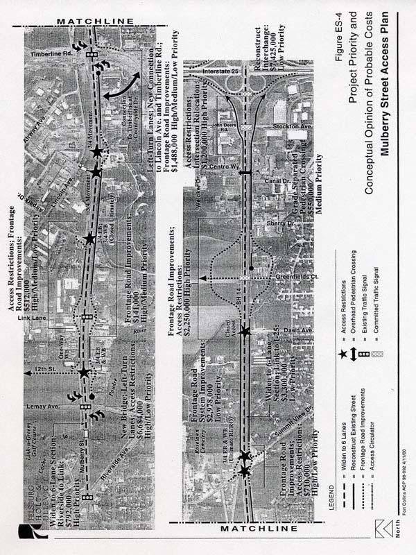
16 Page ix
17 Restrict access to ¾ movements at approximately 375 feet to the east of Lemay Avenue (12th Street), approximately midpoint between Airpark Drive and Timberline Road (includes a new access to Lincoln Avenue), and Summit View Drive (ultimately a RIRO). Restrict access at Airpark Drive to ¾ movements on the north side of the state highway mainline and close access to the frontage road on the south side of the state highway mainline. Close the Dawn Drive access with the state highway mainline. Install new traffic signals at Greenfields Court (expected completion date: Spring, 2000) and at the re-constructed Stockton Avenue/John Deere Road intersection when appropriate MUTCD traffic signalization warrants are met. Replace the existing bridge over the Cache La Poudre River between Riverside and Lemay Avenues to accommodate additional lanes on SH 14 (when necessary). Provide a public street connection to the west side of Timberline Road approximately 475 feet to the south of Mulberry Street, thereby converting the existing T intersection to a four-legged intersection and providing rear access to the properties along the south side of Mulberry Street. Provide a grade-separated pedestrian crossing near the Canal Drive and Centro Way intersections. Ultimately reconstruct the I-25 interchange area to convert the interchange from a cloverleaf design to a diamond interchange. Develop a six-lane roadway along Mulberry Street to meet the City s Master Street Plan recommendation, including bike lanes and sidewalk along the frontage roads. Cost Estimates It has been estimated that all of the improvements recommended in the Access Control Plan could be implemented for approximately $53,091,000 (in Year 2000 dollars). This estimate is for construction costs only and does not include right-of-way acquisition or displacement/ relocation costs. The cost estimates for each of the corridors are more clearly defined as follows: North College Avenue: - Short-Term = $ 1,638,000 - Long-Range = $20,739,000 Jefferson Street/Riverside Avenue = $ 2,549,000 Mulberry Street = $28,165,000 $53,091,000 Page x
18 Implementation The improvements recommended in the Access Control Plans represent both Short-Term and Long-Range plans and, as such, will be implemented over time as traffic and safety needs arise and as funding allows. Future funding for implementation will require participation from both public and private sources. The designs shown in these plans are schematic concept alignments. Detailed engineering drawings of exact roadway alignments and other access related improvements will be conducted as project funding is identified and will consider constraints due to natural area features, storm drainage, flood plain issues and other topographic features. In order to ensure that these improvements can be implemented in the future, it is important that the Access Control Plans be adopted by each of the governing entities in the corridor and that they be used in all transportation and land use planning which could affect either US 287 or SH 14. Therefore, it is recommended that the US 287 and SH 14 Access Control Plans be adopted through Intergovernmental Agreements (IGA) between CDOT, Larimer County and the City of Fort Collins. Since conditions may change over time, a key element of the IGA s is a specified process for modifying the plan in the future. This process calls for the creation of an Advisory Committee comprised of one representative from each of the signatories of the IGA. Amendment requests would be reviewed by the Committee and changes could be made only with the affirmative vote of all signatories. The Advisory Committee will review the Access Control Plans and IGA s at least every three years for needed updates and will adjust project cost estimates annually to reflect inflation. This process should ensure continuing coordination between the agencies in each corridor. Page xi
A raised and landscaped median will be constructed in South College Avenue between Trilby Road and Skyway Drive.
 5.0 ACCESS CONTROL PLAN This section presents the Access Control Plan Update which has been formulated through the considerable input of the governing agencies, business owners, organized homeowner groups,
I. INTRODUCTION. Project Background and Study Area
 I. INTRODUCTION Project Background and Study Area Freedom Parkway is a key east-west corridor connecting I-25 on the west to the Town of Kersey on the east, running approximately one to two miles south
NORTH-SOUTH CORRIDOR STUDY EXECUTIVE SUMMARY. Executive Summary
 Executive Summary Background As congestion continues to affect mobility in the region, the Ozarks Transportation Organization (OTO) is particularly concerned with traffic movement. The North-South Corridor
Scope of Services. River Oaks Boulevard (SH 183) Corridor Master Plan
 Corridor Master Plan") Scope of Services River Oaks Boulevard (SH 183) Corridor Master Plan PROJECT AREA The project area consists of the River Oaks Boulevard (SH 183) corridor bounded by SH 199 at the northern end and the Trinity
Scope of Services River Oaks Boulevard (SH 183) Corridor Master Plan PROJECT AREA The project area consists of the River Oaks Boulevard (SH 183) corridor bounded by SH 199 at the northern end and the Trinity
PREPARED FOR: PLATTEVIEW ROAD CORRIDOR STUDY EXECUTIVE SUMMARY
 PREPARED FOR: PLATTEVIEW ROAD CORRIDOR STUDY EXECUTIVE SUMMARY SEPTEMBER 2016 Introduction The Platteview Road Corridor Study was led by the Metropolitan Area Planning Agency (MAPA) with assistance from
The Illinois Department of Transportation and Lake County Division of Transportation. Route 173, including the Millburn Bypass
 The Illinois Department of Transportation and Lake County Division of Transportation welcome you to this Public Hearing for U.S. Route 45 from Illinois Route 132 to Illinois Route 173, including the Millburn
ALTERNATIVES. NCDOT made an early decision to first determine how to build the project (construction method) followed by what to build (alternatives).
 followed by what to build (alternatives).") III. ALTERNATIVES A. CONSTRUCTION METHOD ALTERNATIVES NCDOT made an early decision to first determine how to build the project (construction method) followed by what to build (alternatives). One of the
III. ALTERNATIVES A. CONSTRUCTION METHOD ALTERNATIVES NCDOT made an early decision to first determine how to build the project (construction method) followed by what to build (alternatives). One of the
SH 199 Corridor Master Plan. Community Meeting No. 2 May 31, 2017
 Community Meeting No. 2 May 31, 2017 Transportation Projects On or Near SH 199 SH 199 from 0.3 miles south of FM 1886 to south end of Lake Worth bridge Construct freeway mainlanes and frontage roads 10-Year
PROJECT BACKGROUND. Preliminary Design Scope and Tasks
 PROJECT BACKGROUND Preliminary Design Scope and Tasks The purpose of this Study is the development of preliminary designs for intersection improvements for Trunk Highway (TH) 36 at the intersections of
Right-of-Way Acquisitions and Relocations Technical Memorandum
 Right-of-Way Acquisitions and Relocations Technical Memorandum Southeast Extension Project Lincoln Station to RidgeGate Parkway Prepared for: Federal Transit Administration Prepared by: Denver Regional
COLVER ROAD INDUSTRIAL CONCEPT PLAN
 COLVER ROAD INDUSTRIAL CONCEPT PLAN A CONCEPTUAL LAND USE AND TRANSPORTATION PLAN FOR TA-4 AN URBAN RESERVE AREA OF THE CITY TALENT City of Talent Adopted by City Council Resolution No., June, 2015 PART
INFRASTRUCTURE EXISTING INFRASTRUCTURE A. Circulation B. Signals C. Drainage D. Utilities
 7.01. EXISTING INFRASTRUCTURE A. Circulation B. Signals C. Drainage D. Utilities 7.02. PROPOSED INFRASTRUCTURE A. Overall Concept B. Circulation C. Signals D. Drainage 7.03. INFRASTRUCTURE MAP A. Key Infrastructure
Alternatives Development Three conceptual alternatives were developed for the Race Road/Jessup Village Planning Study and are described below:
 Race Road/Jessup Village Planning Study (H550601) Project Newsletter Spring 2015 Project Description The Study Team, consisting of staff from Anne Arundel County (Department of Public Works and Department
2017 General Obligation Bond
 2017 General Obligation Bond Presentation of Public and Council Projects to the Transportation & Mobility Stakeholder Committee April 13, 2017 Agenda Deferred Maintenance Project Development Process Projects
ARGENTA TRAIL (CSAH 28/63) REALIGNMENT SOUTH PROJECT (CP 63-25)
 REALIGNMENT SOUTH PROJECT (CP 63-25)") ARGENTA TRAIL (CSAH 28/63) REALIGNMENT SOUTH PROJECT (CP 63-25) Preliminary Design Report February 2015 Prepared For: City of Inver Grove Heights Dakota County Prepared By: Kimley-Horn and Associates,
ARGENTA TRAIL (CSAH 28/63) REALIGNMENT SOUTH PROJECT (CP 63-25) Preliminary Design Report February 2015 Prepared For: City of Inver Grove Heights Dakota County Prepared By: Kimley-Horn and Associates,
Public input has been an important part of the plan development process.
 Lakewood s Comprehensive Plan recognizes that transportation helps shape the community, and that the way the community provides for the safe and efficient movement of people affects the character of the
4.1 Build Alternative 1 Construction Phasing
 SECTION 4 Implementation Plan This section discusses potential segmentation of the build alternatives into multiple projects for implementation of improvements to the NSH from Rabbit Creek Road to 36th
The transportation system in a community is an
 7 TRANSPORTATION The transportation system in a community is an important factor contributing to the quality of life of the residents. Without a sound transportation system to bring both goods and patrons
Existing Transportation System 5-1
 5-1 The Jackson County transportation system is served by several modes of transportation including streets and highways, multi-modal, non-motorized, rail, and aviation. While the focus of the transportation
Introduction. Chapter 1. Purpose of the Comprehensive Plan Plan Organization Planning Process & Community Input 1-1
 Chapter 1 Introduction Lakewood 2025: Moving Forward Together Purpose of the Comprehensive Plan Plan Organization Planning Process & Community Input 1-1 Purpose of the Comprehensive Plan The Comprehensive
Project Overview. Get Involved. Public Information Meeting. Contact Information
 Get Involved VDOT representatives will review and evaluate information received as a result of this meeting. Please fill out the comment sheet provided in this brochure if you have any comments or questions.
2. AGENCY COORDINATION AND PUBLIC INVOLVMENT
 2. AGENCY COORDINATION AND PUBLIC INVOLVMENT This chapter discusses the process carried out for conducting agency coordination and public involvement activities. TECHNICAL ADVISORY COMMITTEE A Technical
City of Toronto. Emery Village Transportation Master Plan
 City of Toronto Emery Village Transportation Master Plan May 2009 Emery Village Transportation Master Plan Toronto, ON May 2009 Consulting Inc. 100 York Blvd., Suite 300 Richmond Hill, ON L4B 1J8 Tel:
Section 1. Executive Summary
 Executive Summary (This page left blank intentionally) Executive Summary Background Economic growth in southern Leavenworth County over the past decade has been strong. As both the number of business and
1.0 INTRODUCTION 1.1 TH 14 WEST STUDY AREA Project Description Functional Classification Purpose of the Project
 1.0 INTRODUCTION 1.1 TH 14 WEST STUDY AREA 1.1.1 Project Description The Trunk Highway (TH) 14 West Corridor is a two-lane roadway approximately 22 miles in length. Located in Nicollet County, the corridor
5.0 IMPLEMENTATION STRATEGIES
 5.0 IMPLEMENTATION STRATEGIES 5.1 Recommended Alternative This chapter discusses the anticipated steps needed to move each project from recommendation to construction. Since full funding for these alternatives
CITY OF LAKEWOOD 2012 THREE-MILE PLAN
 CITY OF LAKEWOOD 2012 THREE-MILE PLAN SECTION 1: INTRODUCTION This document constitutes the s Three-Mile Plan for the unincorporated area three miles in width around the City s perimeter, as required by
Comprehensive Development Guide
 INDUSTRIAL ELEMENT Comprehensive Development Guide 1 Industrial Element 7.1 Hardin County Industrial Overview BG PKWY Fort Knox Industrial Corridor Comprised of 11 parcels totaling 720 acres of land 68
CHAPTER 7: Transportation, Mobility and Circulation
 AGLE AREA COMMUNITY Plan CHAPTER 7 CHAPTER 7: Transportation, Mobility and Circulation Transportation, Mobility and Circulation The purpose of the Transportation, Mobility and Circulation Chapter is to
PROJECT STATEMENT LOCATION/DESIGN PUBLIC HEARING. 19 th AVENUE NORTH EXTENSION PROJECT FROM SPRINGDALE DRIVE TO NORTH 2 ND STREET/U.S.
 PROJECT STATEMENT LOCATION/DESIGN PUBLIC HEARING 19 th AVENUE NORTH EXTENSION PROJECT FROM SPRINGDALE DRIVE TO NORTH 2 ND STREET/U.S. 67 HEARING LOCATION: ERICKSEN COMMUNITY CENTER 1401 11 TH AVENUE NORTH
Capital Projects in and near Odenton Town Center
 Capital Projects in and near Odenton Town Center Map ID Anne Arundel County Department of Public Works This project provides for the design, right of way acquisition, and construction of approximately
Welcome. Northern Segment of Hwy 100 I-90 to South of Madison Street Meeting Goals:
 Welcome Northern Segment of Hwy 100 I-90 to South of Madison Street Meeting Goals: - Review Environmental Assessment - Share Preferred Alternative -Receive Public Comments 2003 EA Preferred Alternative
Cottage Grove Road Reconstruction. City of Madison Engineering
 Public Informational Meeting Cottage Grove Road Reconstruction October 8, 2015 Presentation Outline Introduction Project Purpose & Need Proposed Design Overview Environmental Concerns Pedestrian Needs
City of Golden. Annexation Study Area Report
 City of Golden Annexation Study Area Report July 2016 Adopted by Planning Commission Resolution No. PC16-11 City Council Resolution No. 2497 RESOLUTION PC16-11 A RESOLUTION OF THE CITY OF GOLDEN PLANNING
TRANSPORTATION ELEMENT GOALS, OBJECTIVES, AND POLICIES
 TRANSPORTATION ELEMENT GOALS, OBJECTIVES, AND POLICIES GOAL 2 The City shall provide a safe, convenient, effective, and energy efficient multimodal transportation system which is coordinated with the Future
4-Town Comprehensive Plan DRAFT 7/30/07
 4-Town Comprehensive Plan DRAFT 7/30/07 Acknowledgements ning Committee Town of Harrisburg Norman Roof Randy Nicol Town of Martinsburg Terry Thisse Paul Kelly Town of Montague Jan Bagdanowicz Wendy Perry
1.0 Circulation Element
 5/9/18 1.0 Circulation Element 1.1 Introduction As growth and development occur in Apache County, enhancements to its circulation system will be necessary. With time, more roads will be paved and air and
MEMORANDUM. DATE: March 15, Chairman and Members Community Redevelopment Agency. Leif J. Ahnell, C.P.A., C.G.F.O. Executive Director
 MEMORANDUM DATE: March 15, 2019 TO: FROM: Chairman and Members Community Redevelopment Agency Leif J. Ahnell, C.P.A., C.G.F.O. Executive Director SUBJECT: Camino Square, IDA No. CRP-16-02, located at 171
COUNCIL COMMUNICATION
 Meeting Date: June 13, 2017 COUNCIL COMMUNICATION Agenda Item: Agenda Location: Consent Calendar Work Plan # 194,195, 196 Legal Review: 1 st Reading 2 nd Reading Subject: A resolution approving Thornton
1. Introduction. Purpose and Context of This Plan
 INTRODUCTION 1 1. Introduction Purpose and Context of This Plan The East Mulberry Corridor Plan represents a joint planning effort between Larimer County, the City of Fort Collins and concerned citizens.
Chapter 1 - General Design Guidelines CHAPTER 1 GENERAL DESIGN GUIDELINES
 CHAPTER 1 GENERAL DESIGN GUIDELINES 1.0 INTRODUCTION This Publication has been developed to provide current, uniform procedures and guidelines for the application and design of safe, convenient, efficient
Project Overview. Fairfax County Parkway Widening Fairfax County. Get Involved. Public Information Meeting. Contact Information
 Get Involved VDOT representatives will review and evaluate information received as a result of this meeting. Please fill out the comment sheet provided in this brochure if you have any comments or questions.
Definitions. Average Daily Traffic Demand (ADT): The actual number or projected number of cars that pass a point in a 24-hour period.
: The actual number or projected number of cars that pass a point in a 24-hour period.") Definitions Access Management: A combination of physical techniques and transportation policies used to control the flow of traffic between roads and the surrounding lands. Alternative City Form Scenarios:
Definitions Access Management: A combination of physical techniques and transportation policies used to control the flow of traffic between roads and the surrounding lands. Alternative City Form Scenarios:
Staybridge Suites. Aerial Site Map CCR POL. 1 inch = 17,493 feet. 1 inch = 250 feet. Vicinity Map. Zoning Map RL.
 Staybridge Suites Aerial Site Map 1 «2nd St 1st St 14 Vine Mulberry _ ^ U V Drake Lemay Prospect Shields Mountain Vista Buckingham Park Taft Hill Douglas Horsetooth Timberline 3rd St Vicinity Map E Lincoln
RZC Public View Corridors and Gateways
 RZC 21.42 Public View Corridors and Gateways 21.42.010 Purpose 21.42.020 Scope and Authority 21.42.030 Administration 21.42.040 Gateways Design 21.42.050 Unidentified Public Views 21.42.060 Identification
1.0 Introduction. Purpose and Basis for Updating the TMP. Introduction 1
 1.0 Introduction The Town of Castle Rock is situated between the metropolitan areas of Denver and Colorado Springs, amidst a unique terrain of rolling hills, mesas, ravines, and waterways. Like many Front
Project Study Report Equivalent The Old Road Widening SIX FLAGS MAGIC MOUNTAIN. On Street The Old Road Between Magic Mountain Pkwy And Turnberry Lane
 Project Study Report Equivalent The Old Road Widening SIX FLAGS MAGIC MOUNTAIN On Street The Old Road Between Magic Mountain Pkwy And Turnberry Lane On Street Henry Mayo Drive Between The Old Road And
East Corridor Final Environmental Impact Statement
 East Corridor Final Environmental Impact Statement Alternatives Considered Operating Plan The requirements for opening day operations versus year 2030 are based on ridership and operations. Opening day
Staff Report and Recommendation
 Community Planning and Development Planning Services 201 W. Colfax Ave., Dept. 205 Denver, CO 80202 p: 720.865.2915 f: 720.865.3052 www.denvergov.org/cpd TO: City Council Neighborhoods and Planning Committee
Bostwick Road. Municipal Class Environmental Assessment. Public Information Centre #2 June 14, City of London
 Bostwick Road Municipal Class Environmental Assessment Public Information Centre #2 June 14, 2017 Welcome! Welcome to the 2 nd Public Information Centre for the. Representatives from the and the consulting
Iowa s Statewide Urban Design Standards Promote Improved Access Management
 Iowa s Statewide Urban Design Standards Promote Improved Access Management David J. Plazak and Dale S. Harrington Center for Transportation Research and Education Iowa State University 2901 South Loop
Location. Served. Category. Units Start Year. Previous Appropriations
 20142018 CAPITAL IMPROVEMENT PLAN ($ Thouss) CITY OF HOUSTON STREET & TRAFFIC CONTROL Project: TC Jester: Washington to I 10 N100002 Paving Drainage Project Description Project provides for the design
State Highway 121 Southwest Parkway. Fort Worth s Transportation Success Story in Design and Cooperation
 State Highway 121 Southwest Parkway Fort Worth s Transportation Success Story in Design and Cooperation Greater Fort Worth Association of Realtors October 24, 2007 Presented by: Dan Lamers, P.E. North
Public Hearing. Charlotte County-Punta Gorda MPO - Meeting Rooms A and B March 14, open house at 4 p.m., formal presentation at 5 p.m.
 Public Hearing Charlotte County-Punta Gorda MPO - Meeting Rooms A and B March 14, 2019 open house at 4 p.m., formal presentation at 5 p.m. Welcome to the Public Hearing for the Harborview Road (CR 776)
IMPLEMENTATION STRATEGIES. In This Chapter. Goals & Strategies 182 Project List 183 Future Land Use 186 CHAPTER 11 IMPLEMENTATION STRATEGIES
 In This Chapter Goals & Strategies 182 Project List 183 Future Land Use 186 11 IMPLEMENTATION STRATEGIES NORTH AUGUSTA, SC 2017 COMPREHENSIVE PLAN 179 Individual commitment to a group effort that is what
TENNESSEE STATE ROUTE 109 CORRIDOR MANAGEMENT AGREEMENT MEMORANDUM OF UNDERSTANDING CORRIDOR MANAGEMENT ALONG STATE ROUTE 109
 TENNESSEE STATE ROUTE 109 CORRIDOR MANAGEMENT AGREEMENT MEMORANDUM OF UNDERSTANDING CORRIDOR MANAGEMENT ALONG STATE ROUTE 109 I. Purpose The purpose of this Agreement is to provide a framework for the
Preliminary Design Review. Poudre Garage Mixed Use December 14, 2015
 Preliminary Design Review December 14, 2015 1 Development Review Guide STEP 2 of 8 PRELIMINARY DESIGN REVIEW: APPLICATION General Information Preliminary design review is an opportunity for an applicant
New York Avenue Streetscape and Trail Project Public Meeting #1 Summary
 New York Avenue Streetscape and Trail Project Public Meeting #1 Summary I. King Jordan Student Academic Center (SAC) Gallaudet University, Washington, DC February 23, 2017 Table of Contents 1.0 Introduction...
M E M O R A N D U M July 27, 2018
 M E M O R A N D U M July 27, 2018 To: Southlake 2035 Corridor Planning Committee From: Kenneth Baker, Sr. Director of Planning and Development Services Subject: Item #6 First National Bank Purpose Review,
SECTION 4(f) DE MINIMIS DOCUMENTATION
 DE MINIMIS DOCUMENTATION") SECTION 4(f) DE MINIMIS DOCUMENTATION Illinois Route 60/83 IL 176 to the intersection of IL 60 (Townline Road) Lake County P-91-084-07 Mundelein Park and Recreation District Project Limit SECTION 4(f)
SECTION 4(f) DE MINIMIS DOCUMENTATION Illinois Route 60/83 IL 176 to the intersection of IL 60 (Townline Road) Lake County P-91-084-07 Mundelein Park and Recreation District Project Limit SECTION 4(f)
Route 1 Corridor Study
 Route 1 Corridor Study Westbrook, Connecticut A Vision for the Connecticut Shoreline Public Informational Meeting July 28, 2015 Lower Connecticut River Valley Council of Governments Fitzgerald & Halliday,
Illustration of Eastlake Farmer s Cooperative Grain Elevator. Chapter 5: implementation 5-1
 Illustration of Eastlake Farmer s Cooperative Grain Elevator Chapter 5: implementation 5-1 chapter 5: implementation Introduction The Eastlake Subarea Plan includes a wide range of recommendations intended
Mavis Road Class Environmental Assessment
 Mavis Road Class Environmental Assessment Public Information Centre #2 Wednesday November 9, 2016 6:00 to 8:00 p.m. Please sign in and complete a comment sheet Review the displays on your own or join in
Section 9 NEIGHBORHOOD DESIGN
 Section 9 NEIGHBORHOOD DESIGN City of Lancaster Comprehensive Plan D u n k i n, S e f k o & A s s o c i a t e s, I n c. NEIGHBORHOOD DESIGN INTRODUCTION There are many ways in which a neighborhood can
MAIN STREET ECONOMIC DEVELOPMENT STRATEGY
 MAIN STREET ECONOMIC DEVELOPMENT STRATEGY A PATHWAY TO A BETTER POUGHKEEPSIE DRAFT Working Paper #2: Planning Strategies Submitted December 1 st, 2015 to the City of Poughkeepsie LAND USE LAW CENTER PACE
University Parkway Corridor Plan. Public Workshop Sept. 18, 2017
 University Parkway Corridor Plan Public Workshop Sept. 18, 2017 AGENDA 1. Overview of Process 2. Study Area 3. Components of the Plan 4. What We Know 5. What We Have Heard 6. Tonight s Input 7. Next Steps
RESOLUTION NO R
 e e RESOLUTION NO R04 0054 BE IT RESOLVED by the Mayor and City Council ofthe City ofpapillion that The Papillion Comprehensive Plan is hereby amended to incorporate the Option A Future Land Use Map Transportation
master plan of highways bus rapid transit amendment
 Scope of Work master plan of highways bus rapid transit amendment September 2011 Montgomery County Planning Department M-NCPPC MontgomeryPlanning.org 1 Scope of Work master plan of highways bus rapid transit
Executive Summary. NY 7 / NY 2 Corridor
 Executive Summary NY 7 / NY 2 Corridor Transportation and Land Use Study December 2005 Prepared for: Town of Colonie Capital District Transportation Committee Prepared by: Introduction: Land use decisions
112th Avenue Light Rail Options Concept Design Report JUNE 2010 PREPARED FOR PREPARED BY TBG PGH
 112th Avenue Light Rail Options Concept Design Report JUNE 2010 PREPARED FOR PREPARED BY TBG060310124909PGH C ontents Introduction 1 Project Overview 1 Public Involvement and Technical Coordination 4 Description
VILLAGE OF BOLTON HERITAGE CONSERVATION DISTRICT PLAN
 Page 1 1. INTRODUCTION AND BACKGROUND 1.1 THE PROJECT VILLAGE OF BOLTON HERITAGE CONSERVATION DISTRICT PLAN TERMS OF REFERENCE The Town of Caledon (Town) is a large, predominantly rural municipality with
Ashland BRT Environmental Assessment: logos of CTA, CDOT, Chicago Department of Housing and Economic Development
 Ashland BRT Environmental Assessment: logos of CTA, CDOT, Chicago Department of Housing and Economic Development Overview The Chicago Transit Authority (CTA), in partnership with the Chicago Department
I-90 Mississippi River Bridge & Interchange Project
 I-90 Mississippi River Bridge & Interchange Project Presentation Outline I. Background: Context & Need for Project II. Preferred Alternative Overview III. Project Development IV. Project Management Tools
REQUEST Current Zoning: O-15(CD) (office) Proposed Zoning: TOD-M(CD) (transit oriented development mixed-use, conditional)
 (office) Proposed Zoning: TOD-M(CD) (transit oriented development mixed-use, conditional)") Rezoning Petition 2016-117 Zoning Committee Recommendation January 4, 2017 REQUEST Current Zoning: O-15(CD) (office) Proposed Zoning: TOD-M(CD) (transit oriented development mixed-use, conditional) LOCATION
Rezoning Petition 2016-117 Zoning Committee Recommendation January 4, 2017 REQUEST Current Zoning: O-15(CD) (office) Proposed Zoning: TOD-M(CD) (transit oriented development mixed-use, conditional) LOCATION
EXECUTIVE SUMMARY. Introduction
 EXECUTIVE SUMMARY Introduction State Route 68 is a designated scenic route that connects the world-renowned Monterey Peninsula to US Highway 101 and the Salinas Valley. SR 68 is a key route for bicycle,
PROPOSED IMPROVEMENTS
 IV. PROPOSED IMPROVEMENTS The proposed improvements for each alternative carried forward are discussed below. A. FUNCTIONAL CLASSIFICATION AND ROADWAY CROSS-SECTIONS The classifications of the roadways
WELCOME! 8 8:30 6: TH STREET IMPROVEMENTS. Open House. Presentation & Q&A
 WELCOME! 168 TH STREET IMPROVEMENTS 6:30 Open House 7 8 Presentation & Q&A 8 8:30 Open House WELCOME Todd Pfitzer City of Omaha Engineer Bob Stubbe City of Omaha Public Works Director Jon Meyer Project
AGENDA ITEM: IOWA. west] that were not FISCAL IMPACT. the City of Clive. STAFF REVIEW. Resolution II. Amendment PREPARED BY: REVIEWED BY:
![AGENDA ITEM: IOWA. west] that were not FISCAL IMPACT. the City of Clive. STAFF REVIEW. Resolution II. Amendment PREPARED BY: REVIEWED BY:](/thumbs/93/112428810.jpg "AGENDA ITEM: IOWA. west] that were not FISCAL IMPACT. the City of Clive. STAFF REVIEW. Resolution II. Amendment PREPARED BY: REVIEWED BY:") AGENDA ITEM: CITY OF WAUKEE, IOWA CITY COUNCIL MEETING COMMUNICATION MEETING DATE: March 7, 2016 AGENDA ITEM: Consideration of approval of a resolution approving Engineering Services Amendment No. 1 with
AGENDA ITEM: CITY OF WAUKEE, IOWA CITY COUNCIL MEETING COMMUNICATION MEETING DATE: March 7, 2016 AGENDA ITEM: Consideration of approval of a resolution approving Engineering Services Amendment No. 1 with
M-11 (Wilson Avenue) Access Management Plan
 Access Management Plan") M-11 (Wilson Avenue) Access Management Plan Acknowledgements M-11 (Wilson Avenue) Corridor Advisory Committee: City of Walker Michigan Department of Transportation (MDOT) Grand Valley Metropolitan Council
M-11 (Wilson Avenue) Access Management Plan Acknowledgements M-11 (Wilson Avenue) Corridor Advisory Committee: City of Walker Michigan Department of Transportation (MDOT) Grand Valley Metropolitan Council
Olde Towne Vision Plan
 Olde Towne Vision Plan Introduction In 2016, the City of Bellevue will complete its move of City offices from Olde Towne Bellevue to its new municipal complex on Wall Street. The City intends to sell its
Fifth and Detroit Street Design May 2017 Capital Improvements Committee. DOWNTOWN Street Design
 1 Fifth and Detroit Street Design May 2017 Capital Improvements Committee Agenda 2 Review Street Configuration Prior Meeting Review Outreach Synopsis Functional Street Design Refinements Curb Edge, Turning
WELCOME TO OPEN HOUSE TWO November 28, 2018
 Langstaff Road Weston Road to Highway 7 Class Environmental Assessment Study WELCOME TO OPEN HOUSE TWO November 28, 2018 Please sign in and join our mailing list Study Overview York Region is conducting
PLANNING COMMISSION. Submitted
 PLANNING COMMISSION City Hall 1275 Main Street El Centro, CA 92243 Submitted PLANNING COMMISSION ACTION ITEM (1844) Meeting: 05/10/16 12:00 AM Department: Community Development Category: Public Hearing
PLANNING COORDINATING COMMITTEE
 PLANNING COORDINATING COMMITTEE Fall Meeting/Luncheon Welcome! October 16, 2009 PLANNING COORDINATING COMMITTEE Fall Meeting/Luncheon WELCOME! WELCOME! October 16, 2009 October 16, 2009 Agenda I. Lunch/Socialize
Bypass #16 - Bend Parkway (new alignment for US 97) (MP )
 (MP )") Bypass #16 - Bend Parkway (new alignment for US 97) (MP 134.76-141.83) Description: The Parkway is on new alignment for US 97 through Bend. US 97 is a Statewide Highway on the National Highway System that
Bypass #16 - Bend Parkway (new alignment for US 97) (MP 134.76-141.83) Description: The Parkway is on new alignment for US 97 through Bend. US 97 is a Statewide Highway on the National Highway System that
List of Priority Projects
 List of Priority Projects Fiscal Years 2019-20 to 2023-24 June 25, 2018 Amended December 17, 2018 Metropolitan Transportation Planning Organization for the Gainesville Urbanized Area List of Priority
Urban Planning and Land Use
 Urban Planning and Land Use 701 North 7 th Street, Room 423 Phone: (913) 573-5750 Kansas City, Kansas 66101 Fax: (913) 573-5796 Email: planninginfo@wycokck.org www.wycokck.org/planning To: From: City Planning
WHAT IS THE PURPOSE OF THE OPEN HOUSE?
 WHAT IS THE PURPOSE OF THE OPEN HOUSE? OPEN HOUSE PURPOSE The purpose of the open house is to provide an update on the study process and introduce the preliminary concept alternatives. The open house provides
Executive Summary. The goals of the Plan are to:
 Executive Summary The Wiscasset Bath Road Master Plan (Plan) seeks to maximize development opportunities along Bath Road through the strategic coordination of traffic infrastructure improvements, land
LOS ANGELES CITY PLANNING DEPARTMENT STAFF REPORT
 LOS ANGELES CITY PLANNING DEPARTMENT STAFF REPORT LOS ANGELES CITY PLANNING COMMISSION CASE NO: CPC 2006-9374 CRA CEQA: Exempt DATE: December 21, 2006 Location: Valley Plaza and Laurel Plaza TIME: after
2040 Long Range Transportation Plan
 2040 Long Range Transportation Plan Adopted: April 15, 2013 APPENDIX D HIGHWAY NEEDS PLAN PROJECTS FREDERICKSBURG Existing and Committed Projects Fall Hill Avenue/Mary Washington Blvd. (Fredericksburg)
1.0 INTRODUCTION & BACKGROUND
 1.0 INTRODUCTION & BACKGROUND 1.1 GENERAL The Consulting Team was retained by the City of Edmonton in 2010 to complete a for the replacement of the Walterdale Bridge and the approach roads, as required,
Johnson County I-69. Corridor Plan DRAFT DRAFT
 Johnson County I-69 Corridor Plan July 2018 JOHNSON COUNTY CORRIDOR PLAN This page intentionally left blank TABLE OF CONTENTS Chapter 1: Executive Summary... Chapter 2: Introduction... Chapter 3: Existing
Downtown River District
 City & Downtown Development Authority Partnership Infrastructure Analysis & Design Project Transportation & Utilities Fix Current Deficiencies Set the Stage for Future Infill & Redevelopment Who s Involved:
Planning Districts INTRODUCTION
 INTRODUCTION To facilitate detailed examination of development prospects for all areas of the community, Delano has been divided into 14 planning districts. The location of these planning districts is
ROAD CLOSURE AND LAND USE AMENDMENT SILVER SPRINGS (WARD 1) NORTHEAST OF NOSEHILL DRIVE NW AND SILVER SPRINGS ROAD NW BYLAWS 2C2018 AND 29D2018
 NORTHEAST OF NOSEHILL DRIVE NW AND SILVER SPRINGS ROAD NW BYLAWS 2C2018 AND 29D2018") Page 1 of 19 EXECUTIVE SUMMARY This application proposes redesignating two parcels in the community of Silver Springs from Special Purpose Future Urban Development (S-FUD) District and undesignated road
Page 1 of 19 EXECUTIVE SUMMARY This application proposes redesignating two parcels in the community of Silver Springs from Special Purpose Future Urban Development (S-FUD) District and undesignated road
Appendix A. Summary of Key Findings: US Hwy Corridor Study. Retail-Commercial Development Plan Page A-1
 Retail-Commercial Development Plan 2020 Appendix A Summary of Key Findings: US 24-40 Hwy Corridor Study Introduction The US 24-40 Corridor Study was initiated by state, regional, county and city officials
510 Highways, Streets & Roads Comprehensive Plan Section 510
 511 510 Comprehensive Plan Section 510 Highways, streets, and roads provide for the movement of people and goods from one place to another. These public ways form a network that defines the relationship
Regarding actual construction when development occurs, the following applicable guidelines are provided to address public safety issues:
 MIAMI-DADE COUNTY DEPARTMENT OF PLANNING AND ZONING General Comments 1. COMMENT: A careful review of the application provided shows that there is likely to be an impact on the Miami-Dade Police Department
This Review Is Divided Into Two Phases:
 Semiahmoo Town Centre Review The purpose of this review: To review the Semiahmoo Town Centre Concept Plan, originally approved in 1993, to ensure that this centre will continue to serve the needs of South