Inert Infill & Preservation of SSSI at Horton Landfill. Environmental Statement Non-Technical Summary. July Prepared for: Viridor
|
|
|
- Shanon Melton
- 5 years ago
- Views:
Transcription


1 Inert Infill & Preservation of SSSI at Horton Landfill Environmental Statement Non-Technical Summary Prepared for: Viridor UNITED KINGDOM & IRELAND
2
3 REVISION SCHEDULE Rev Date Details Prepared by Reviewed by Approved by 1 Submission Sarah Martin Planning Consultant Chris Nicoll Principal Planner (Minerals and Waste) Ian Campbell EIA Consultant Imogen Scotney Consultant Barry Gore Director URS Infrastructure & Environment UK Limited Royal Court Basil Close Chesterfield Derbyshire S41 7SL Viridor Ardley Fields Farm Ardley Oxfordshire OX27 7PH iii
4
5 Copyright This Report is the copyright of URS Infrastructure & Environment UK Limited. Any unauthorised reproduction or usage by any person other than the addressee is strictly prohibited. iv
6
7 TABLE OF CONTENTS 1 INTRODUCTION Preamble Background The Environmental Statement Purpose Screening and Scoping THE SITE AND ITS SETTING The Site and its Surroundings Statutory and Non Statutory Land Designations Landscape Historic Environment Ecology Geological Water Environment Air Quality Green Belt THE PROPOSED DEVELOPMENT (THE SCHEME) Scheme Outline ENVIRONMENTAL EFEFCTS Landscape and Visual Natural Heritage (Ecology) Transport Noise and Vibration Air Quality Flood Risk Assessment/Hydrology Natural Heritage (Geology) Other Matters CONCLUSION PLANS AND FIGURES v
8
9 PLANS AND FIGURES Title Reference Scale and Size Revision Site Location Plan NTS.001 1:50,000 (A4) Site Area Plan NTS.002 1:10,000 (A3) Planning Application Area and Land Ownership NTS.003 1:2,500 (A2) Land Designations NTS.004 1:10,000 (A3) Existing Layout NTS.005 1:1,250 (A3) Infill Proposal NTS.006 1:1,250 (A4) Restoration NTS.008 1:1,250 (A3) vi
10
11 LIST OF ABBREVIATIONS AOD Above Ordnance Datum AQMA Air Quality Management Area ES Environmental Statement EIA Environmental Impact Assessment Ha Hectare HGV Heavy Goods Vehicle NPPF National Planning Policy Framework NTS Non-Technical Summary PRoW Public Right of Way SS Supporting Statement SSSI Site of Special Scientific Interest TPA Tonnes per Annum WSCC West Sussex County Council REFERENCING The following definitions have been adopted in this NTS: the Site comprises the 3.5 ha planning application area outlined in red on figure NTS.003. the Infill Area comprises the 1.8 ha void containing the Horton Clay Pit geological Site of Special Scientific Interest shown on figure NTS.003. Horton Landfill Site is the total extent of the 32 ha landfill site. It closed for the reception of waste in 2012, restoration has recently been completed and the land in aftercare. Offices and Admin comprise the administration office, landfill gas compound and leachate treatment plant as indicated on figure NTS.003. the SSSI is the 0.38 ha area and geological exposures of the Horton Clay Pit geological Site of Special Scientific Interest. vii
12
 which accompanies an application for planning permission submitted to West Sussex County Council (WSCC) by")
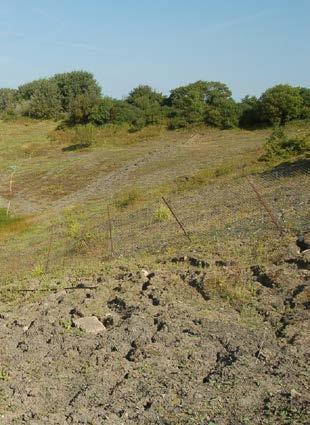
13 1 INTRODUCTION 1.1 Preamble 1.2 Background This document is a non-technical summary of the Environmental Statement (ES) which accompanies an application for planning permission submitted to West Sussex County Council (WSCC) by Viridor Waste Management Limited (Viridor) which relates to proposed development at Horton Landfill Site. Horton Landfill Site is located to the south of the village of Small Dole, approximately 6km north of Shoreham-by-Sea as identified on figure NTS.001 and lying at NGR TQ The area around the Site is illustrated on Plan NTS.002. The restored landfill site is located in a former clay pit that closed for the reception of wastes in The landfill planning permission required Viridor not to infill the north east corner of the clay pit where a geological exposure of Gault clay is safeguarded by Natural England as the Horton Clay Pit geological Site of Special Scientific Interest (SSSI). The landfill was thus designed and completed with the exposure retained within a void of some 15-20m depth. The SSSI designation covers approximately 0.38ha of the 32ha landfill site area. A photograph of the SSSI from the restored landfill site is provided below. Small Dole village Horton Clay Pit geological SSSI Restored Horton Landfill Photograph 1 the Infill Area and Horton Clay Pit SSSI view east from the restored Horton Landfill Site (URS 2013) Over many years the open exposure of Gault clay has suffered from serious weather erosion, surface cracking and rainwater penetration that have caused repeated local slope failures which are undermining the integrity of the SSSI. Natural England (legal overseers of the SSSI) now considers the SSSI has degenerated to a condition they class as unfavourable decline. Technical assessments conclude that because of the low natural strength of Gault clay and the steep slope angle to which it was excavated, slope failures will continue unless there is direct intervention. Viridor has reached agreement with Natural England to protect and preserve the long term future of the SSSI by infilling the void with inert materials with restoration of the 1
14 final landform. Inert materials comprise uncontaminated non-putrescible stones and rock, rubble, soils, typically arising from excavations and construction projects. The Scheme will firstly clean up the geological site (to allow inspection by Natural England) then protect and preserve the SSSI by a controlled infill operation. Should access be required in the future the location of the preserved SSSI exposure will be marked out at the new finished ground level. Finished ground levels will merge with those of the adjacent restored landfill site. The planning application submitted by Viridor therefore requests temporary planning permission to preserve the SSSI by importing about 92,000m 3 of inert infill material over an infill period of 12 months across a 5 day working week, followed by restoration to grassland, trees and open habitat attractive to invertebrates and reptiles. 1.3 The Environmental Statement Purpose The Environmental Statement (ES) presents the findings from the Environmental Impact Assessment (EIA) of the proposed development, hereafter called the Scheme. The ES has been prepared in accordance with the Town and Country Planning (Environmental Impact Assessment) (England) Regulations 2011 (the EIA Regulations). The purpose of the ES is to ensure that: relevant environmental issues are assessed appropriately; potential environmental impacts associated with the operational and aftercare phases of the proposed Scheme are identified, together with appropriate mitigation measures (if necessary); and interested parties are given the opportunity to address any relevant issues. The ES seeks to present the Scheme proposals and the results of specialist assessments in a clear and unbiased manner and has been produced to accompany the planning application referred to above Screening and Scoping Preliminary details of the application and ES have been the subject of an EIA Screening decision and EIA Scoping Opinion issued by WSCC (see Section 2.2 for details). The specific topics assessed by the EIA are: landscape and visual; natural heritage (ecology); transport; noise (and vibration); air quality; flood risk assessment/hydrology; natural heritage (geodiversity); and other matters, e.g. Public Rights of Way. A short summary description of these environmental factors and their relevance within the Scheme is provided in Section 4 below. 2
15 2 THE SITE AND ITS SETTING 2.1 The Site and its Surroundings The Infill Area is located in the north-east corner of Horton Landfill Site entirely within its fenced site boundary. The Infill area is substantially screened from close by external views (outside Horton Landfill Site) by boundary trees and other vegetation. Natural ground level around the Infill Area lies at about 20m AOD, the base of the void has a lowest point of 5m AOD. The local area comprises low lying gently rolling agricultural land falling towards the River Adur to the west. Higher land (up to 200m AOD) of the north facing chalk escarpment of the South Downs lies about 2km to the south. The highest point of the restored landfill is presently at about 32m AOD. The area around Horton Landfill Site is predominantly rural and in agricultural use lying on the east edge of the valley and floodplain of the River Adur. Adjacent land uses include: to the north of the Site is a small collection of out buildings associated with Oxcroft farm use; immediately east of the Site is Henfield Road (A2037) and beyond this is the Mackley Industrial Estate comprising approximately 30 businesses; to the north-east of the Site are a small number of residential properties on Henfield Road and approximately 300 m north of the Site is the built up area of Small Dole; the closest residential property to the Infill Area is Woodside about 50m to the north-east and on the east side of the A2037 adjoining the Mackley s Industrial Estate; slightly further away to the east is the entrance to the Hillside Scout Camp; to the north, west and south the land surrounding the landfill is predominantly in agricultural use with small woods and occasional isolated residential properties. 2.2 Statutory and Non Statutory Land Designations Landscape The Horsham District Council Landscape Character Assessment (2003) identifies Horton Landfill as falling within landscape character areas D2 Henfield and Small Dole Farmlands and O3 Steyning and Henfield Brooks. The Site falls within area D2. Area D2 is described as an undulating landscape of low ridges and narrow valleys with small streams Historic Environment Ecology The nearest listed building to the Site (Nightingales) is located approximately 540m to the south of the Infill Area and 75m south of the main site access road. There is one scheduled monument within a 2km search area from the Site, the Cross Dyke on Tottington located approximately 1.5km to the south-east. There are no designated habitats afforded protection within the Infill Area or the Horton Landfill Site. Approximately 350m to the north-west of the Infill Area and within 100m of the access haul road is Horton Wood, an ancient and semi natural woodland; 280m to the east of the Site is Tottington Wood which is an ancient woodland and local nature reserve; and 3
16 2.2.4 Geological 2.5km to the south-east of the Site is the South Downs Environmentally Sensitive Area and the Beeding Hill to New Timber Hill SSSI. The boundary of the extensive River Adur water meadows and Wycham Wood Site of Nature Conservation Interest is located close to the south-west corner of the landfill. The Horton Clay Pit SSSI is located within the Infill Area. The SSSI was designated in 1991 relating to the exposure of the Lower Gault Formation that was excavated during development of the clay pit. The Gault clay includes an important sequence of sedimentary stratigraphy and marine fossil assemblages through a vertical section Water Environment Air Quality Green Belt The Environment Agency online mapping identifies that almost all the Site falls within Flood Zone 1, which has the lowest risk of flooding. One small corner is mapped of the landfill main access road is considered to be at risk from flooding which is believed to be a historical reference to previous ground levels. The access road lies level and is not known by Viridor to have experienced flooding. The base of the Infill Area is a receptor for rainwater that is pumped out on a regular basis and periodically dries out. The Site is not located within a ground water source protection zone or aquifer. The Site does not fall within an existing or proposed Air Quality Management Area (AQMA). Horsham District Council does not have any areas of designated Green Belt. 4
17 3 THE PROPOSED DEVELOPMENT (THE SCHEME) 3.1 Scheme Outline The Scheme comprises the following main proposals: Insitu preservation of the SSSI by the import and placement of approximately 92,000m 3 of inert material within the Infill Area; a temporary development period in which infilling will take place over the course of twelve months; access to the Site via the existing landfill site access only; a voluntary routeing undertaking offered by Viridor so HGVs avoid Small Dole village; development of a temporary haul road constructed across the former landfill area; management controls to minimise noise and dust; restoration to surrounding ground levels as indicated on plan NTS.008; surface marking of the position of the buried geological exposure for future identification; restoration of the new land profile to grassland, woodland and open spaces to provide local biodiversity for reptiles and invertebrates, and a surface ditch to provide drainage to prevent flooding; daytime working Monday to Friday only; and a 5 year programme of site aftercare. 5
18 4 ENVIRONMENTAL EFEFCTS The findings of the environmental factors considered by the EIA procedures and listed in Section 1.2 are provided in brief summary below Landscape and Visual The Site lies within National Character Area (NCA) 125 South Downs. NCA 121 Low Weald also lies within the wider study area used to asses this topic. The former is noted for its natural beauty and importance for access and recreation, the latter is predominantly agricultural with many densely wooded areas. Overall the Site has been heavily influenced by mineral extraction and landfill activity. Due to its relatively unmanaged state, absence of characteristic landscape elements and incongruous landform, the Site is currently assessed as being of low landscape quality and poor condition. Views: The Site is well screened by fencing, mature vegetation and landform, including the landform of the restored Horton Landfill Site, such that there are no direct views of the Infill Area from publicly accessible locations external to the Site. Partial first floor views are potentially obtained from properties on the edge of Small Dole to the north of the Site although these are likely to be limited by intervening vegetation. Distant elevated views towards the Site are obtained from the South Downs ridgeline, incorporating Beeding Hill and Tottington Hill, within the SDNP. Views of the perimeter access road and top of the restored Horton landfill Site are obtained from locations to the west, principally from within the Adur valley. During infilling in landscape terms effects on the Site will be of moderate adverse significance given the low sensitivity and high magnitude of effect and the context of occurring within a former landfill site. Landscape effects within the wider study area will be of minor adverse significance during infilling given the low sensitivity and low magnitude of effect. By year 15 landscape effects on the Horton Landfill Site will be minor beneficial significance, within the wider study area negligible beneficial significance Natural Heritage (Ecology) Habitats within the Site include semi-improved neutral grassland, standing water, scrub, marginal vegetation, bare ground, ephemeral/short perennial and tall ruderal habitats. The Site is bordered to the north by scrub and improved grassland, scrub to the east, and semi-improved neutral grassland (a continuation of the landfill site) to the west and south. No mature trees will be affected. No habitats within the planning application boundary are considered to fall within the Habitat of Principal Importance or Local Biodiversity Action Plan priority habitat definitions and there are no protected sites within the Site. Ecological surveys of the Site and adjacent area has been undertaken, including a Phase 1 habitat mapping survey and Phase 2 field surveys for reptiles and amphibians (including great crested newt) in water bodies around the Site. Other species were not surveyed due to the limited range of habitats available. Great crested newts were not found in the Site or the two closest water bodies, surveys of water bodies in the wider area found a population considered to be of County level importance. Common species of reptiles (grass snake, slow worm and common lizard) were found within the Infill Area. The populations recorded are considered dependent 6
19 4.1.3 Transport on the hedgerows, scrub and grassland which adjoin it, including the more established areas of restored landfill cap to the south east of the Infill Area. The Horton Landfill Site is considered to be of up to the district value level for terrestrial invertebrates with the grizzled skipper seen; (it favours unimproved grassland and recently abandoned industrial sites). The Scheme is not predicted to have any environmental effects on any of the habitat sites with statutory protection. In terms of the effect on local habitat the initial loss of habitat in the Infill Area (e.g. grassland/bare ground) is assessed as a moderate adverse effect on invertebrates that is significant prior to mitigation. The loss of this habitat and the act of infilling is also predicted to have a moderate adverse effect that is significant prior to mitigation on common reptiles (slow worm, grass snake and common lizard) and also on some terrestrial invertebrate species (e.g. grizzled skipper). Habitat compensation to prevent any net loss of biodiversity as a consequence of the Scheme upon completion of infilling will be secured via restoration to provide grassland, woodland and mosaic habitats that mimic the value and function of those currently present within the Infill Area. Including lowland meadow, woodland planting, bare ground for basking reptiles, raised bunds and scrub for terrestrial invertebrates. Once restoration is established the impact on habitat receptors will be mitigated to reduce the local environmental effects from significant to neutral. The existing landfill site access off the A2037 will be utilised for all lorry movements, it has been reviewed by a highways engineer and found to be fit for the intended purpose. The road s accident record nearby is good with substantial spare flow capacity. The quantative assessment concludes that in terms of total traffic, when considered the worst case scenario of 100% of predicted traffic travelling from the north or south (39 deliveries per day), the proposed infill traffic would not generate sufficient trips to have a significant impact on the local road network. The predicted increase in total traffic flows both north and south of the site on the A2037 are less than 2% which is no more than typical day to day variations in traffic flows. The number of lorry movements is considerably less than when the landfill was operating. The above analysis shows that, in terms of total traffic, the proposed works would not generate sufficient trips to create any discernible environmental impacts associated with increases in traffic. The Scheme includes a voluntary routeing agreement to minimise the amount of HGV traffic travelling through Small Dole and nearby country lanes. The agreement is proposed to minimise amenity impacts arising from lorry traffic but is not necessary to satisfy traffic impact requirements Noise and Vibration To determine the existing noise environment at the nearest residential properties, ambient noise monitoring was undertaken at five locations in the area. The surveys result in a good understanding of the existing noise climate at the closest noise sensitive receptor locations. Noise levels have been predicted for the early stage of infilling when operations will be at the lower levels of the Infill Area and at the higher ground level in the latter stages of restoration. In all cases the adjacent existing acoustic fence remains in place. 7
20 4.1.5 Air Quality The predicted worst case noise levels are calculated to be below the NPPF preferred criterion (a maximum of 10 db over the average measured background level plus up to a limit of 55 dbl Aeq ) by at least 3dB at each location. With the adoption of best practice procedures for control and mitigation noise, it is considered the Scheme will result in a negligible environmental impact due to noise. In the absence of large numbers of heavy plant or piling etc. vibration is not considered to have any significant environmental effects. The Site does not fall within an existing or proposed Air Quality Management Area (AQMA) and is in a rural setting therefore it is considered local air quality will be good. The deposit of the inert infill material is not usually itself associated with the generation of fugitive dust because of the heavy and damp nature of the material, however the passage of vehicles on haul roads associated with the operations can create dust without mitigation through best practice. The magnitude and location of dust impacts are highly variable in nature and can be considered as mainly dependent on the prevailing meteorological conditions at the time and the nature of the dust generating activity. Previous dust monitoring at Horton Landfill Site (undertaken in 2011/12) indicates that the site has experienced no significant fugitive dust issues. One exceedance was recorded on the western edge of the site close to a haul road, and was believed to be caused by an isolated event. All other monitoring points recorded concentrations well below the threshold adopted to indicate significant environmental effects are likely. A reactivation of boundary monitoring forms part of the Scheme. The potential for dust impacts on local receptors including local habitat sites has been assessed. Overall with the adoption of the proposed management scheme the impact on air quality arising from the Scheme is considered to be not significant Flood Risk Assessment/Hydrology The Environment Agency (EA) website identifies that the Infill Area Site lies entirely within Flood Zone 1 and is therefore classed as at low risk from fluvial flooding. A formal flood risk assessment has been completed in accordance with the requirements of the NPPF. The base of the Infill Area is a low lying void, a receptor for rainfall which drains down to small sump has to be dewatered by regular pumping. The Scheme will remove the sump allowing for a gravity field drainage ditch to be introduced at restoration. A small part of the main access road lies within a designated zone at higher risk of flooding (although none is known) but no works are proposed by the Scheme to affect the road structure and thus drainage from and to it. The Infill Area falls within the catchment area of Horton Landfill Site, the drainage scheme for which is approved under the landfill planning permission and the discharge regulated by Environmental Permit. No consequential impact on flooding and drainage is therefore predicted Natural Heritage (Geology) The Horton Clay Pit geological SSSI forms part of the environmental baseline and will be directly impacted upon by the Scheme to a significant level in that direct access to it will be denied. However, this consequence is a result of preservation of the exposure by infill and has been agreed in advance with Natural England. Preservation is 8
21 considered a beneficial effect of the Scheme. Within that context the negative effect on the SSSI is considered outweighed by the positive benefits Other Matters Community and Socio Economic/Amenity Considerations: the construction works at the Site will lead to the creation of some employment opportunities in the supervision of the works and the use of contractors to provide the infill materials. Specific baseline conditions relating to landscape and visual amenity, noise and vibration, and air quality are considered in the above sections. No Public Rights of Way will be affected. Cumulative and Combined: Cumulative effects are those that could arise as a result of impacts from several different schemes. In this case URS are not aware of any schemes likely to give rise to significant cumulative effects. There may be some combined effects of the Scheme. For example, noise and air quality impacts may both potentially affect sensitive receptors in close proximity during operations. These have been included in the in the individual assessments as appropriate. Risk of Accidents: the Scheme does not involve materials that could be harmful to the environment (including people) in the event of an accident. There are therefore no such potential environmental effects. 9
22 5 CONCLUSION The ES undertakes a comprehensive assessment of the environmental implications of the construction and operation of the Scheme. It includes detailed assessment of a wide range of environmental issues and considers the effect of mitigation measures proposed. Implementation of the mitigation measures defined therein will mean that residual effects should be minimised to an acceptable degree. In terms of the loss of immediate access to the SSSI, in itself this is considered a significant impact but one that is outweighed by the benefit of long terms preservation and is acceptable within that context. 10
23 6 PLANS AND FIGURES 3 13
PANSHANGER QUARRY, Hertfordshire
 PANSHANGER QUARRY, Hertfordshire Proposed enhanced restoration of Phases F & H Briefing Note 1 March 2015 INERT (INACTIVE) RESTORATION MATERIALS, CONTROLS AND OPERATIONS 1 Introduction This briefing note
University Park, Worcester Non Technical Summary December 2011
 University Park, Worcester Non Technical Summary December 2011 Introduction UW Wrenbridge LLP, a Joint Venture Company of the University of Worcester and Wrenbridge Land Ltd (the Applicants ) intend to
BREEDON NORTHERN LIMITED
 Non Technical Summary CONTENTS 1 INTRODUCTION... 1 2 SITE DESCRIPTION... 1 3 DESCRIPTION OF THE DEVELOPMENT... 6 4 NEED FOR THE DEVELOPMENT... 8 5 KEY ISSUES CONSIDERED IN THE ENVIRONMENTAL IMPACT ASSESSMENT...
NON-TECHNICAL SUMMARY
 Proposed Sand and Gravel Extraction and Associated Processing Operations with Restoration to a Mixture of Agriculture and Nature Conservation including Areas of Shallow Water at Hedgeley, Northumberland
Barvills Solar Farm Environmental Statement Non-Technical Summary
 Barvills Solar Farm Environmental Statement Non-Technical Summary 13 March 2015 Produced for Prepared by St John s House Queen Street, Manchester M2 5JB Contents Contents... 2 1 Introduction... 3 1.1 Development
Longbridge Town Centre Phase 2 Planning Application
 Longbridge Town Centre Phase 2 Planning Application Non-Technical Summary of the Environmental Statement December 2013 Introduction A full application for Planning Permission has been submitted to Birmingham
Replacement Golf Course Facilities and Residential Development, Churston. Environmental Statement Non-Technical Summary
 Replacement Golf Course Facilities and Residential Development, Churston Environmental Statement Non-Technical Summary July 2011 Reproduced from the Ordnance Survey s map with the permission of the Controller
Inert Recycling (UK) Ltd Boxgrove Quarry Restoration Environmental Statement
 Ltd Boxgrove Quarry Restoration Environmental Statement") November 2013 Non-Technical Summary Empress House, 12 Empress Road, Lyndhurst, SO43 7AE Tel: 023 8028 3226 Email: waste.enquiries@wyg.com Introduction Background EIA is a process by which the environmental
November 2013 Non-Technical Summary Empress House, 12 Empress Road, Lyndhurst, SO43 7AE Tel: 023 8028 3226 Email: waste.enquiries@wyg.com Introduction Background EIA is a process by which the environmental
LAND AT HOWES LANE, BICESTER ENVIRONMENTAL STATEMENT NON-TECHNICAL SUMMARY. March 2017 Our Ref: Q70433
 LAND AT HOWES LANE, BICESTER ENVIRONMENTAL STATEMENT NON-TECHNICAL SUMMARY March 2017 Our Ref: Q70433 Contents 1 INTRODUCTION AND SITE DESCRIPTION... 1 2 EIA METHODOLOGY... 5 3 ALTERNATIVES... 6 4 DESCRIPTION
Cardiff International Sports Village Waterfront Development Volume IV : Non-Technical Summary of the Environmental Statement
 Greenbank Partnerships Ltd October 2012 Cardiff International Sports Village Waterfront Development Volume IV : Non-Technical Summary of the Environmental Statement Environmental Statement - Non Technical
ABBEY MANOR GROUP/SAINSBURY S SUPERMARKETS LTD
 ABBEY MANOR GROUP/SAINSBURY S SUPERMARKETS LTD Mixed Use Development including Business Park and Foodstore Land at Bunford Park, Bunford Lane, Yeovil Environmental Statement: Non-Technical Report June
The Place Solar Farm
 The Place Solar Farm Environmental Statement Non-Technical Summary 28 August 2014 Produced for Prepared by St John s House Queen Street, Manchester M2 5JB Contents Contents... 2 1 Introduction... 3 1.1
Request for a Scoping Opinion by Provectus. Proposed Surface Mining of Coal on Land west off the A61, Hill Top Farm, Clay Cross, Derbyshire
 Request for a Scoping Opinion by Provectus Proposed Surface Mining of Coal on Land west off the A61, Hill Top Farm, Clay Cross, Derbyshire January 2012 Contents 1 Introduction & Background... 1 2 Site
South Whitehaven, Cumbria EIA
 South Whitehaven, Cumbria EIA Environmental Statement - Non Technical Summary June 2013 in association with 1. Introduction Story Homes is applying to Copeland Borough Council (CBC) for a new residential
Grantham Southern Quadrant Link Road Environmental Statement
 Grantham Southern Quadrant Link Road Environmental Statement Non Technical Summary Introduction Lincolnshire County Council (LCC) is submitting a planning application for the proposed implementation of
Former RAF Sealand Site EIA
 Praxis (Holdings) Ltd. Former RAF Sealand Site EIA Environmental Statement - Non Technical Summary February 2012 in association with P a g e 1 1. Introduction Praxis (Holdings) Ltd. is applying to Flintshire
Statutory and Non-Statutory Designated Sites and Ecology
 Statutory and Non-Statutory Designated Sites and Ecology The National Planning Policy Framework considers the conservation and enhancement of the natural environment in chapter 11 paragraphs 109-119, where
Land at BROOK STREET PROPERTIES TENCREEK FARM, LISKEARD. Environmental Statement: Non-Technical Summary
 BROOK STREET PROPERTIES TENCREEK FARM, LISKEARD Land at Environmental Statement: Non-Technical Summary Introduction Brook Street Properties is applying to Cornwall Council for outline planning permission
Environmental Impact Assessment
 Environmental Impact Assessment Environmental impact assessment (EIA) is the process of systematically drawing together an assessment of the likely significant environmental effects of a development project.
NON TECHNICAL SUMMARY
 CONTENTS Introduction...1 Site Setting and Description...3 Proposed Development...3 Proposed Time Extension...4 Proposed Lateral Extension...4 Improvement of the main access road (Downs Lane)...4 Restoration
Town and Country Planning (Environmental Impact Assessment Regulations) 2011 SCOPING OPINION
 2011 SCOPING OPINION") Town and Country Planning (Environmental Impact Assessment Regulations) 2011 SCOPING OPINION Application Site and Description of Development Proposed new quarry at Culham, Oxfordshire Land and Mineral
Town and Country Planning (Environmental Impact Assessment Regulations) 2011 SCOPING OPINION Application Site and Description of Development Proposed new quarry at Culham, Oxfordshire Land and Mineral
LAND AT MIDDLETON STONEY ROAD AND HOWES LANE, BICESTER ENVIRONMENTAL STATEMENT NON-TECHNICAL SUMMARY. June 2017 Our Ref: Q70433
 LAND AT MIDDLETON STONEY ROAD AND HOWES LANE, BICESTER ENVIRONMENTAL STATEMENT NON-TECHNICAL SUMMARY June 2017 Our Ref: Q70433 Contents 1 INTRODUCTION... 2 2 SITE DESCRIPTION... 5 3 EIA METHODOLOGY...
Velindre Cancer Centre Environmental Statement Vol.1: Environmental Statement Text. Chapter 1: Introduction
 Velindre Cancer Centre Environmental Statement Vol.1: Environmental Statement Text Chapter 1: Introduction Draft - March 2017 Prepared by: Address: Email: Website: Mott McDonald, The Urbanists and HLM
7 Scoping and Introduction to the Assessments
 7 Scoping and Introduction to the Assessments 7.1 Scope of the assessments 7.1.1 Rule 8 of the TWR makes provision for an applicant to request a scoping opinion from the SoS indicating the information
Kier Infrastructure and Overseas Limited Greenburn Surface Mine, Dalgig Farm Site
 Kier Infrastructure and Overseas Limited Greenburn Surface Mine, Dalgig Farm Site Planning application pursuant to s.42 Town and Country Planning (Scotland) Act 1997 to amend the restoration scheme Volume
Land at Porch Farm, Kingsclere Ecology Briefing Paper, April 2016 C_EDP3343_01a
 C_EDP3343_01a Introduction 1.1 This Ecology Briefing Paper has been prepared by The Environmental Dimension Partnership Ltd (EDP) on behalf of Linden Homes. This briefing paper considers the ecological
E16: MAINTENANCE OF LANDSCAPED AREAS
 HIGH SPEED TWO INFORMATION PAPER E16: MAINTENANCE OF LANDSCAPED AREAS This paper outlines the proposed approach to the maintenance of landscaped areas created for HS2 Phase One. It will be of particular
M4 Corridor around Newport Environmental Statement Volume 3: Appendices
 Environmental Statement Volume 3: Appendices Environmental Statement Volume 3: Appendices At Issue March 2016 CVJV/AAR 3 rd Floor Longross Court, 47 Newport Road, Cardiff CF24 0AD Volume 3: Contents 1
MAIDSTONE MEDICAL CAMPUS LTD LAND AT NEWNHAM PARK, MAIDSTONE
 MAIDSTONE MEDICAL CAMPUS LTD LAND AT NEWNHAM PARK, MAIDSTONE Land at Environmental Statement: Non-Technical Summary Introduction Maidstone Medical Campus Ltd is applying to Maidstone Borough Council for
DEFGH. Crystal Place Park. Environmental Impact Assessment (EIA) Elin Thomas and Emily Low Waterman Environmental
 Elin Thomas and Emily Low Waterman Environmental") DEFGH Crystal Place Park Environmental Impact Assessment (EIA) Elin Thomas and Emily Low Waterman Environmental 10.12.07 EIA Presentation Content What is EIA? Legal Requirements Process Q&A Key Topics
DEFGH Crystal Place Park Environmental Impact Assessment (EIA) Elin Thomas and Emily Low Waterman Environmental 10.12.07 EIA Presentation Content What is EIA? Legal Requirements Process Q&A Key Topics
Rempstone Extension - East Leake 2014
 Overall Restoration of East Leake Quarry Sand Martin Face Southern Agricultural Corridor Wetland Ponds/Conservation Corridor following Sheepwash Brook Reinstated Bridleway/Footpaths Southern Agricultural
Land at Weymouth Gateway Proposed hotel and pub / restaurant Non-technical summary. Premier Inns Ltd February 2011
 February 2011 Introduction NTS.1 In April 2007, New Look Retailers Ltd submitted an outline planning application to Weymouth and Portland Borough Council to redevelop the Mount Pleasant Business Park
Bloor Homes Stubbocks Walk North Hertfordshire ENVIRONMENTAL STATEMENT NON-TECHNICAL SUMMARY
 Bloor Homes Stubbocks Walk North Hertfordshire ENVIRONMENTAL STATEMENT NON-TECHNICAL SUMMARY December 2016 Environmental Statement: Non-Technical Summary Stubbocks Walk, North Hertfordshire J S Bloor
PERSIMMON HOMES (SW) LIMITED LAND AT ADDINGTON, LISKEARD ENVIRONMENTAL STATEMENT NON-TECHNICAL SUMMARY
 LIMITED LAND AT ADDINGTON, LISKEARD ENVIRONMENTAL STATEMENT NON-TECHNICAL SUMMARY") PERSIMMON HOMES (SW) LIMITED LAND AT ADDINGTON, LISKEARD ENVIRONMENTAL STATEMENT NON-TECHNICAL SUMMARY APRIL 2010 INTRODUCTION This document is the Non-Technical Summary (NTS) of an Environmental Statement
PERSIMMON HOMES (SW) LIMITED LAND AT ADDINGTON, LISKEARD ENVIRONMENTAL STATEMENT NON-TECHNICAL SUMMARY APRIL 2010 INTRODUCTION This document is the Non-Technical Summary (NTS) of an Environmental Statement
Moat Lane Regeneration Project Environmental Statement
 AECOM Environment Towcester Regeneration Ltd. October 2012 Moat Lane Regeneration Project Environmental Statement Non-Technical Summary Prepared by:... Checked by:... Sophie Collins Scott Wilson Environmental
volume 11 environmental assessment section 2 environmental impact assessment Part 7 ha 218/08
 DESIGN MANUAL FOR ROADS AND BRIDGES volume 11 environmental assessment section 2 environmental impact assessment Part 7 ha 218/08 glossary of terms Used in DMRB Volume 11, Sections 1 and 2 SUMMARY This
3.1 This evidence is based on the landscape and visual impact assessment included in Chapter 10 and Appendix I of the EIS.
 LANDSCAPE & VISUAL 1 QUALIFICATIONS AND EXPERIENCE 1.1 My name is Raymond Holbeach and I am a Regional Director for RPS Planning & Environment with full responsibility for management of the RPS Belfast
Burgess Hill, Land South of Freeks Farm Phase 1 of Burgess Hill Northern Arc East Environmental Statement Non-Technical Summary September 2016
 Burgess Hill, Land South of Freeks Farm Phase 1 of Burgess Hill Northern Arc East Environmental Statement September 2016 Contents 1.0 Introduction... 1 1.1 Background... 1 1.2 Environmental Assessment...
NON-TECHNICAL SUMMARY
 NON-TECHNICAL SUMMARY THE HIDE, BISHOP AUCKLAND PROPOSED ECO CHALET DEVELOPMENT NON-TECHNICAL SUMMARY 1 Introduction 1.1.1 This non-technical summary for the (ES) prepared in relation to the proposed eco-chalet
The Town and Country Planning (Environmental Impact Assessment) (Wales) Regulations 2016, Regulation 13 Scoping Opinion
 (Wales) Regulations 2016, Regulation 13 Scoping Opinion") Mr Graham Clark Berrys Newchurch Farm Kinnersley Hereford HR3 6QQ BY EMAIL The Town and Country Planning (Environmental Impact Assessment) (Wales) Regulations 2016, Regulation 13 Scoping Opinion SC/2017/0001
Mr Graham Clark Berrys Newchurch Farm Kinnersley Hereford HR3 6QQ BY EMAIL The Town and Country Planning (Environmental Impact Assessment) (Wales) Regulations 2016, Regulation 13 Scoping Opinion SC/2017/0001
PINEWOODS HOLIDAY PARK: HORSE PADDOCK. Non-Technical Summary
 PINEWOODS HOLIDAY PARK: HORSE PADDOCK June 2014 1 Introduction 1.1 The existing Pinewoods Holiday Park is located approximately 1 km to the north of Wells-nextthe-Sea on the north Norfolk coast. Pinewoods
Neighbourhood Planning Site Assessment Pro-forma and Guide Version 2
 Neighbourhood Planning Site Assessment Pro-forma and Guide Version 2 September 2014 Site HNP 006 Land East of Stanbridge Road and North of Lower Road 1. Background information Site location and use Site
Thornton Road, Pickering Environmental Statement Non-Technical Summary. January 2016
 Thornton Road, Pickering Environmental Statement Non-Technical Summary January 2016 EIA Quality This Environmental Statement, and the Environmental Impact Assessment (EIA) carried out to identify the significant
Cranbrook EXPANSION ENVIRONMENTAL STATEMENT: NON-TECHNICAL SUMMARY PRODUCED BY DAVID LOCK ASSOCIATES
 Cranbrook EXPANSION ENVIRONMENTAL STATEMENT: NON-TECHNICAL SUMMARY PRODUCED BY DECEMBER 2014 CRANBROOK EXPANSION AREAS ENVIRONMENTAL STATEMENT NON TECHNICAL SUMMARY Submitted in support of Outline Planning
Wyvern Park Skipton Environmental Statement. Non-technical Summary - April 2015
 Wyvern Park Skipton Environmental Statement Non-technical Summary - April 2015 BWB Consulting Ltd Whitehall Waterfront 2 Riverside Way Leeds LS1 4EH Telephone: +44(0)113 233 8000 Copyright This Report
NON-TECHNICAL SUMMARY
 Hybrid outline/detailed planning application comprising an outline planning application for 196 residential dwellings, landscaping, open space, estate roads and infrastructure, plus 4 permanent gypsy and
Report reference: LT/WTE/LZH/1655/01/SCOPING June 2015
 PROPOSALS FOR THE SCOPE AND CONTENT OF AN APPLICATION FOR PLANNING PERMISSION AND AN ENVIRONMENTAL STATEMENT FOR THE EXTRACTION OF LIMESTONE FROM EXTENSION AREAS AT WHITWELL QUARRY, DERBYSHIRE Report reference:
Site Assessment Technical Document Appendix A: Glossary
 Central Bedfordshire Council www.centralbedfordshire.gov.uk Site Assessment Technical Document Appendix A: Glossary July 2017 1.1.11-1 - ii Appendix A: Glossary Term Agricultural Land Classification AONB
LAND AT WEST YELLAND. Environmental Statement Non-Technical Summary Welbeck Strategic Land LLP
 LAND AT WEST YELLAND Environmental Statement Non-Technical Summary Welbeck Strategic Land LLP May 2014 Quality Management Issue/revision Issue 1 Revision 1 Revision 2 Revision 3 Remarks Draft FINAL Date
Land at Whiteditch Lane, Newport, Essex
 Land at Whiteditch Lane, Newport, Essex Ecology Report Produced for Sworders Agricultural By March 2013 Document Control: Version Date Version Details Prepared by Checked by Approved by 0.1 01.03.2013
Policy DM19: Development and Nature Conservation
 Avonmouth Wetland Habitat Project October 2010 and December 2011 (the Cresswell study). Policy Links Bristol Local Plan Core Strategy Lead Policy BCS4: Avonmouth and Bristol Port BCS9: Green Infrastructure
DEVELOPMENT MANAGEMENT REPORT
 ITEM A08-1 DEVELOPMENT MANAGEMENT REPORT TO: BY: DATE: DEVELOPMENT: SITE: WARD: APPLICATION: APPLICANT: Development Management Committee Development Manager Proposed live/work unit in connection with existing
Sandwich Town Tidal Defences Environmental Statement Non Technical Summary
 Sandwich Town Tidal Defences Environmental Statement Non Technical Summary Environment Agency Introduction The Environment Agency is proposing to construct a scheme to reduce the risk of tidal flooding
Tandridge Local Plan Assessing the Ecological Suitability of 183 sites considered for development Tandridge District Council, Surrey
 Tandridge Local Plan Assessing the Ecological Suitability of 183 sites considered for development Tandridge District Council, Surrey PLANNING I DESIGN I ENVIRONMENT 1.0 INTRODUCTION TEP conducted Site
HANSON UK MANOR FARM QUARRY MILTON KEYNES SAND AND GRAVEL EXTRACTION OFF HAVERSHAM ROAD, NEW BRADWELL.
 HANSON UK MANOR FARM QUARRY MILTON KEYNES SAND AND GRAVEL EXTRACTION OFF HAVERSHAM ROAD, NEW BRADWELL. ENVIRONMENTAL STATEMENT NON-TECHNICAL SUMMARY JANUARY 2013 Hanson Quarry Products Europe Ltd Ashby
ES 5. Drakelow Park. Environmental Statement. Volume 5: Non Technical Summary. Lead Author Waterman Energy, Environment and Design Ltd
 Drakelow Park ES 5 Environmental Statement Volume 5: Non Technical Summary Lead Author Waterman Energy, Environment and Design Ltd April 2009 Environmental Statement Volume 5: Non-Technical Summary DRAKELOW
9 Archaeology & Cultural Heritage
 High Clachaig Wind Farm Scoping Report Page 56 9 Archaeology & Cultural Heritage 9.1 Introduction Cultural heritage in this context means the above- and below-ground archaeological resources, built heritage,
Non-technical summary
 Non-technical summary Introduction NTS.1 is applying for outline planning permission for a residential development of up to 80 dwellings on land at Hambrook, on the northern fringe of Bristol. NTS.2 An
HS2 Environment. Protecting the environment
 HS2 Environment Protecting the environment Approach to mitigation EIA Regulations require an ES to include a description of the measures envisaged in order to avoid, reduce and, if possible, remedy significant
Public Consultation. Land at Monks Farm, North Grove. Welcome
 Welcome Welcome to our public exhibition for development on Land at Monks Farm, orth Grove. Gallagher Estates and Gleeson Strategic Land are preparing an outline planning application for new homes, open
Planning and Regulatory Committee 20 May Applicant Local Councillor Purpose of Report
 Planning and Regulatory Committee 20 May 2014 7. APPLICATION FOR PLANNING PERMISSION FOR THE CARRYING-OUT OF DEVELOPMENT PURSUANT TO PLANNING PERMISSION REFERENCE NUMBER 603451 DATED 28 FEBRUARY 2007 WITHOUT
Ʊ ± ªº Œª ºª ø ª ª ± ª
 Ʊ ± ªº Œª ºª ø ª ª ± ª ø º Õ± ± ± Œ±øºÙ Õ ß Æª ø檺 ±Æ ƪ ø檺 æß Æ± Ʊ ª ø ø fl ª ª ± ê ø Õ øæß ª ª æªæ Ó ÔÌ Non-Technical Summary Introduction A planning application has been submitted to the Vale
My role and specialisms. Worked at spawforths for nearly 13 years. Worked on EIA projects for approx. 10 years and had co-ordinator role for approx.
 My role and specialisms. Worked at spawforths for nearly 13 years. Worked on EIA projects for approx. 10 years and had co-ordinator role for approx. 9 years. Lead EIA activities in the company. The majority
Kings Road Industrial Development, Immingham. Environmental Impact Assessment. Non Technical Summary
 Environmental Impact Assessment Non Technical Summary Report prepared by: Ecus Ltd. Brook Holt 3 Blackburn Road Sheffield S61 2DW 0114 266 9292 December 2013 Page left intentionally blank INTRODUCTION
3. Neighbourhood Plans and Strategic Environmental Assessment
 1. Introduction This report sets out a draft Screening Determination for the Preston Parish Council s Neighbourhood Plan and has been prepared by rth Hertfordshire District Council. The purpose of the
Plumpton Neighbourhood Development Plan Revised Pre Submission Document - Regulation 14 Consultation
 REPRESENTATIONS... Plumpton Parish Council Plumpton Neighbourhood Development Plan Revised Pre Submission Document - Regulation 14 Consultation Representations submitted on behalf of: Cala Homes (South
INTRODUCTION. Land south of Bishopswood Lane, Tadley
 0 INTRODUCTION THE SITE Introduction Gladman Developments Ltd. has successfully invested in communities throughout the UK over the past 0 years, developing high quality and sustainable residential, commercial
Environmental Statement Volume 1: Non-Technical Summary. for Welbeck Strategic Land LLP
 Volume 1: Non-Technical Summary for Welbeck Strategic Land LLP May 2013 Environmental Impact Assessment Volume 1 Non-Technical Summary Non-Technical Summary Introduction Welbeck Strategic Land LLP (hereafter
NON TECHNICAL SUMMARY
 NON TECHNICAL SUMMARY INTRODUCTION NTS.1 CEMEX UK Properties Limited is applying for planning permission to South Cambridgeshire District Council (SCDC) for the redevelopment of the former CEMEX cement
Viewpoint 1. Location: View from Murch Road on the north eastern boundary of Application Site. Viewing south / southwest.
 Application Site (eastern field) Former site of St. Cyres Lower School Murch Road 1 Location: View from Murch Road on the north eastern boundary of Application Site. Viewing south / southwest. Baseline
UTT/16/1466/DFO GREAT DUNMOW MAJOR
 UTT/16/1466/DFO GREAT DUNMOW MAJOR PROPOSAL: LOCATION: APPLICANT: AGENT: Reserved matters approval for the accesses to the site and principal roads within the site including spine road following outline
Parish of Repton NEIGHBOURHOOD DEVELOPMENT PLAN
 Parish of Repton NEIGHBOURHOOD DEVELOPMENT PLAN BASIC CONDITIONS STATEMENT December 2018 CEF 4 Legal Requirements This statement has been produced by the NDP Working Group on behalf of Repton Parish Council
Kilnw Envir ood Vale onmental Statement Volume 3: Non Technical Summary July 2010
 Kilnwood Vale Environmental Statement Volume 3: Non Technical Summary July 2010 Kilnwood Vale Environmental Impact Assessment Environmental Statement Volume 3 KILNWOOD VALE ENVIRONMENTAL STATEMENT NON-TECHNICAL
South Macclesfield Development Area, Phase 1 Environmental Statement Non- Technical Summary. For Engine of the North
 South Macclesfield Development Area, Phase 1 Environmental Statement Non- Technical Summary For Engine of the North April 2015 Contents Contents 3 1 Introduction 1 2 The Proposals 5 3 Alternative Options
Longbridge East : Site Wide and Phase One Development
 Longbridge East : Site Wide and Phase One Development Non-Technical Summary of the August 2011 Introduction St Modwen Developments Ltd intend to submit a new outline planning application for Longbridge
Comments on the proposed scope are requested from WCC/NBBC officers to be provided to SLC Rail by 25 th March 2016 and sent to
 Introduction WCC have indicated that in advance of the surveys and assessments being undertaken consultation should be undertaken with technical officers of both Warwickshire CC and Nuneaton and Bedworth
Ref: A073350/SM/sm Date: 13 September 2013
 Ref: A073350/SM/sm Date: 13 September 2013 Ian Parkinson Development Control Team Leader Planning Portsmouth City Council Civic Offices Guildhall Square Portsmouth PO1 2AY Dear Ian LIGHT & GLEAVE VILLA
VALLEY PARK, DIDCOT. Non-Technical Summary. December On behalf of Taylor Wimpey UK Limited, Persimmon Homes and Hallam Land Management Ltd.
 VALLEY PARK, DIDCOT Non-Technical Summary December 2014 On behalf of Taylor Wimpey UK Limited, Persimmon Homes and Hallam Land Management Ltd. CONTENTS 1 Introduction... 2 2 The Proposed Development...
Habitat Regulations Assessment (HRA) Screening Determination. May 2017
 Screening Determination. May 2017") Cholsey Parish Council Cholsey Neighbourhood Plan Habitat Regulations Assessment (HRA) Screening Determination May 2017 Cholsey Neighbourhood Plan Page! 1 of! 10 SASR - HRA v1.1 Page Left Intentionally
Cholsey Parish Council Cholsey Neighbourhood Plan Habitat Regulations Assessment (HRA) Screening Determination May 2017 Cholsey Neighbourhood Plan Page! 1 of! 10 SASR - HRA v1.1 Page Left Intentionally
Re-location of Rugby Farmers Mart
 Re-location of Rugby Farmers Mart LaSalle Investment Management Barberry Logo here Environmental Statement Non-Technical Summary August 2017 Re-location of Rugby Farmers Mart Non-Technical Summary Report
Land at Rampton Road. Cottenham
 Land at Rampton Road Cottenham Introduction TEP is preparing an outline planning application for 54 dwellings on 6.9 hectares of land adjacent to Rampton Road, Cottenham on behalf of the owners Cambridgeshire
Elvetham Chase, Fleet. Environmental Statement: Non-Technical Summary. November New Fetter Lane London EC4A 1AZ United Kingdom
 Elvetham Chase, Fleet Environmental Statement: Non-Technical Summary November 2016 A Ne w F e tte r P lace 8-10 New Fetter Lane London EC4A 1AZ United Kingdom T +44 (0) 20 7467 1470 F +44 (0) 20 7467 1471
Environmental Statement Non-Technical Summary Blythe Valley Park, Solihull. March 2016
 Environmental Statement Non-Technical Summary Blythe Valley Park, Solihull March 2016 Contents 1. Introduction 1 2. The EIA Process 1 3. The Site and Surroundings 4 4. The Proposed Development 7 5. Needs
PLANNING FOR THE SUPPLY OF BUILDING AND ROOFING STONE The Planning Officers Society 2008
 PLANNING FOR THE SUPPLY OF BUILDING AND ROOFING STONE The Planning Officers Society 2008 Extraction of minerals, including building and roofing stone, from the land requires planning permission under the
i.6 Under this Key Area of Change the Daresbury Strategic Site will deliver:
 I.0 NON-TECHNICAL SUMMARY Introduction i.1 Redrow Homes NW Ltd is applying to Halton Borough Council for planning permission for the development of up to 300 high quality residential dwellings, including
TOWN AND COUNTRY PLANNING ACT 1990 (AS AMENDED).
.") FAO: D. Williams Isle of Anglesey County Council Council Offices Llangefni Anglesey LL77 7TW 16 November 2017 DCRM Ref. No: WN0904-QUD-OS-LET-00002_English Dear Mr Williams TOWN AND COUNTRY PLANNING ACT
FAO: D. Williams Isle of Anglesey County Council Council Offices Llangefni Anglesey LL77 7TW 16 November 2017 DCRM Ref. No: WN0904-QUD-OS-LET-00002_English Dear Mr Williams TOWN AND COUNTRY PLANNING ACT
Strategic Employment Site, on land to the East of the M5, south of Junction 6, west of Pershore Lane. Environmental Statement. Non Technical Summary
 Strategic Employment Site, on land to the East of the M5, south of Junction 6, west of Pershore Lane Environmental Statement Non Technical Summary March 2010 Strategic Employment Site, on Land to the East
DELEGATED REPORT. LOCATION Land At Hawley Common Minley Road Blackwater Camberley Surrey
 DELEGATED REPORT APPLICATION NO. 16/03200/FUL LOCATION Land At Hawley Common Minley Road Blackwater Camberley Surrey PROPOSAL APPLICATION FOR TEMPORARY PLANNING PERMISSION FOR USE OF LAND FOR FILMING AND
Statement of Community Involvement LAND OFF SOUTHDOWN ROAD HORNDEAN, HAMPSHIRE
 LAND OFF SOUTHDOWN ROAD HORNDEAN, HAMPSHIRE CONTENTS Page 1. Introduction 3 2. Pre-application Discussions 4 3. The Consultation Process 5 4. Consultation Feedback 7 5. Responses to Consultation Feedback
London Road, Derker. Non Technical Summary. Introduction
 London Road, Derker Non Technical Summary Introduction The Oldham Rochdale Housing Market Pathfinder was set up to tackle longstanding problems of poor quality housing and to provide the framework for
PROPOSED FRUIT PACKING AND DISTRIBUTION FACILITY AT WARES FARM, LINTON, MAIDSTONE
 Land at PROPOSED FRUIT PACKING AND DISTRIBUTION FACILITY AT WARES FARM, LINTON, MAIDSTONE Environmental Statement: Non-Technical Summary December 2016 Introduction Alan Firmin Ltd are applying to Maidstone
Neighbourhood Planning Local Green Spaces
 Neighbourhood Planning Local Green Spaces Introduction... 2 1. Why green space is important... 4 2. Neighbourhood plans and green space... 6 3. Evidence... 8 Statutory designations... 9 Green space audit...
South Macclesfield Development Area Environmental Statement Non-Technical Summary March 2017
 South Macclesfield Development Area Environmental Statement March 2017 Contents 1.0 Introduction... 2 1.1 Background... 2 1.2 Environmental Assessment... 2 1.3 Site Description... 2 2.0 The Proposals...
Causeway Farm, Petersfield Environmental Statement Non-Technical Summary October 2015
 Causeway Farm, Petersfield Environmental Statement October 2015 2 Contents 1.0 Introduction... 1 1.1 Background... 1 1.2 Environmental Assessment... 1 1.3 Site Description... 3 2.0 The Proposals... 6 2.1
LAND WEST OF ST ANDREWS ROAD
 LAND WEST OF ST ANDREWS ROAD ENVIRONMENTAL STATEMENT VOLUME 3 - NON-TECHNICAL SUMMARY Submitted by Nathaniel Lichfield & Partners on behalf of Redrow Homes Limited July 2014 Applicant: Consultant Team:
Warwickshire County Council. Upper and Lower Brailes. Landscape Study
 Warwickshire County Council Upper and Lower Brailes Landscape Study Produced by WCC Landscape Architects March 2016 Landscape Assessment of Potential Development Sites within the parish of Brailes 1.0
Land at Copshurst Quarry, Stoke-on-Trent. Environmental Impact Assessment. Environmental Statement, Non-Technical Summary.
 VOLUMEI I I NONTECHNI CALSUMMARY Pl anni ngappl i cat i onf ort hepr oposedext ensi ont ocopshur stquar r y Jul y2015 Land at Copshurst Quarry, Stoke-on-Trent Environmental Impact Assessment Environmental
WELCOME GYPSY LANE. Wider Site Location plan. Proposals for the development of LAND OFF FOXLYDIATE LANE WEBHEATH. Proposals for the development of
 WELCOME The developers are preparing an outline planning application for a residential led development and need the community s views in order to develop the proposals further WHAT IS PROPOSED? A high
LAND SECURITIES REDEVELOPMENT OF NEWNHAM COURT SHOPPING VILLAGE, MAIDSTONE
 LAND SECURITIES REDEVELOPMENT OF NEWNHAM COURT SHOPPING VILLAGE, MAIDSTONE Land at Environmental Statement: Non-Technical Summary Introduction Land Securities plc is applying to Maidstone Borough Council
Development of land adjacent to Braggs Farm Lane and Rumbush Lane, Dickens Heath. Welcome. Today s exhibition. The proposal site
 Welcome Welcome to this event to discuss the development of land adjacent to Braggs Farm Lane. is currently in the preliminary stages of designing proposals to sensitively develop this site with high-quality