the green business district
|
|
|
- Jasper Spencer
- 5 years ago
- Views:
Transcription

1 the green business district Hazelwood Studio Ken Doyno, Instructor Dan Rothschild, Instructor Grace Whang, Jessica Kim

2 The Second Avenue intervention is entitled the Green Building District. What this entails is the following: Creating a series of infill developments along Second Avenue through pedestrian-friendly public plazas and park spaces, providing the foundation for economic revival through three interventions that will ultimately serve a greater social need, and unifying the green infrastructure of Hazelwood and the business district to attract outside users and provide amenities for the residents of Hazelwood. Through analysis and the studying process, the three nodes along the Second Avenue with the most catalytic potential are the unified Greenway, the intersection of Second Avenue and Hazelwood Avenue, and the intersection of Second Avenue and Elizabeth Avenue. These interventions are to be implemented within a fifteen year projection.


3 The current conditions within Hazelwood s greenway along Irvine are inconsistent and irregular: there are empty/abandoned lots, unused/ hardly used lots, and lots that are being taken over by the local vegetation. Rather than fight against nature, highlighting the green as an entryway corridor is the seemingly best plan of action. By transforming the local empty lots into park spaces and infilling the sparse and steep landscape with trees, Hazelwood can unify its disjointed greenways into a cohesive landscape fabric and a stabilizing neighborhood force. To highlight the existing historical landmark within the Wood s House, the park can implement its ranger station in the currently unused building: in doing so, the neighborhood can publicly raise awareness to Hazelwood s local amenities, increase local safety efforts, and bring outside users into Hazelwood. By implementing a greenway, Hazelwood s main entryway from the Junction will be a bold green statement found nowhere else within Pittsburgh. Fig 1 & 2 One Year Phasing and Existing Conditions Plan Diagrams Fig 3 Five Year Phasing Diagram of the Hazelwood Greenway Fig 4 Existing to Five Year Conceptual Perspectives


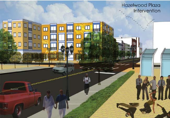
4 Currently, there is a lack of arrival and sense of destination at the intersection of Second Avenue and Hazelwood. By the first year, a simple change of material along the streetscape will define a clear boundary. The vacant lots will be turned into bio-gardens to help heal and clean the existing soil, which will also help clean and beautify the adjacent amenities and the overall Second Avenue corridor. By the tenth year, the simple streetscape will be flanked by mixed used buildings and a hardscaped corner plaza. The potential density that will exist within a five-ten minute walk for the current and future population of Hazelwood will then create a high demand for public transportation. By year fifteen, the fourth corner of Hazelwood will be a light rail stop to service the region. Fig 3 Five Year Phasing Plan Diagram Fig 1 Ten Year Phasing Plan Diagram of Hazelwood and Second Ave The atmosphere along the new Second Avenue is focused on being pedestrian-friendly. The new plantings along the Second Avenue corridor helps slow down traffic as well as provide shade for the pedestrians and bicyclists. A new road called Third Avenue will be constructed to run parallel from Second Avenue to help alleviate the heavy traffic flow. Fig 4 One Year Phasing Plan Diagram Fig 2 Street Cross Section at Hazelwood and Second Ave. Fig 5 Existing Conditions Plan Diagram


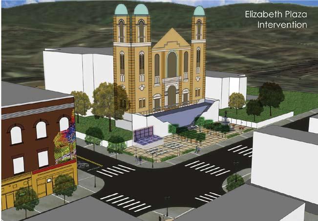
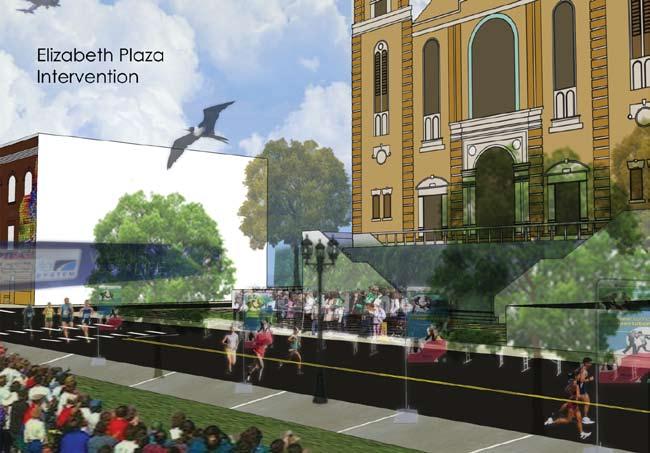
5 Elizabeth s plaza is of a different breed than its Hazelwood counterpart. Rather than having economics and density as the focal points of this intersection, the landmarking the second entryway into the district by highlighting the historic St. Stephen s Church is the focal point of Elizabeth and Second. Fig 1 Five Year Phasing Plan Diagram The current church s entryway is a single stairway that prevents any after-service congregation and promotes an unwelcoming atmosphere. By dropping the land and creating an open plaza with seating, a fountain, a stage, and plenty of light, the Elizabeth Plaza can become an active location for afterservice gatherings for people from that church and adjacent churches. On the other corner of the plaza is a proposed building for a coffee shop/ bakery/gallery. Once again, this can be an active center for Hazelwood residents and especially for the active church community. Fig 4 Ten Year Phasing Plan Diagram of Elizabeth and Second Ave Fig 2 One Year Phasing Plan Diagram Fig 3 Existing Conditions Plan Diagram Fig 4 Ten Year Phasing Plan Diagram of Elizabeth and Second Ave

6

7 Through the first three catalytic nodes a ripple effect will infiltrate the interstitial spaces. One of these spaces includes the current Library. By moving the library into the Spahr Building, the newer building is open to house medical practitioners that can increase the local health care for residents. Furthermore, the new Spahr Library utilizes a historical landmark building, increases the proximity to the YMCA center, and takes advantage of the increase of space for more books, computer labs, office spaces, and study areas for students and adults alike. The adjacent block located to the north of the YMCA will have newly constructed residential row of houses facing the green yard of the Y. The block south of the YMCA will have new outdoor basketball courts and other amenities. Also, stronger connections will be made between the YMCA and the existing playground. By repurposing vacant buildings and lots, the existing neighborhood will be revitalized economically, socially, and physically.
LUNDY S LANE COMMUNITY IMPROVEMENT PLAN STUDY
 PUBLIC INFORMATION MEETING #2 October 12, 2016 LUNDY S LANE COMMUNITY IMPROVEMENT PLAN STUDY AGENDA 5:00 to 5:30pm: Open House 5:30 to 6:15pm: Presentation 6:15 to 7:00pm: Individual paced workshop with
Community Design Plan
 Gardena General Plan 2006 Authority While the is not a required element of a General Plan, it is included because improving the community appearance and image is paramount to the overall quality of life
Community Assistantship Program. Milaca Downtown Revitalization
 Community Assistantship Program Milaca Downtown Revitalization Prepared in partnership with City of Milaca Prepared by Zachary Jorgensen Research Assistant University of Minnesota December, 2009 CAP Report
BROOKLYN PARK / 85TH AVE LRT STATION CDI DEVELOPMENT GUIDELINES DRAFT
 August 2018 Page intentionally left blank The Brooklyn Park Library adjacent to the 85th Ave LRT Station Area. OVERVIEW The Blue Line LRT Extension / Bottineau corridor offers a unique opportunity to leverage
Subarea 4 Indian Creek. Vision The combination of park networks and transportation amenities make Subarea 4 the greenest hub in the Corridor.
 indian creek 180 extends south from 101st Street to I-435. The I-435 and Metcalf intersection is one of the primary intersections in the Kansas City Metro Area. The area includes several residential neighborhoods
Planning Board Briefing
 Planning Board Briefing Why Now? The Sector Plan Implementation Chapter States: Before Stage 1 begins, the following must occur: Approval of the Sectional Map Amendment. Approval of the Greater Lyttonsville
WELCOME and introduction
 1 WELCOME and introduction Mobility Hub Locations within Burlington STUDY OVERVIEW STUDY OBJECTIVES The City of Burlington is developing four Area Specific Plans, one for each of Burlington s Mobility
BRYN MAWR. Tier 2 Characteristics: Location: Lancaster Avenue from Old Lancaster Road on the east to Norwood Avenue on the west
 BRYN MAWR Tier 2 Characteristics: Transit-oriented Mixed use Along Lancaster Avenue Serve township-wide needs Civic space Employment centers Location: Lancaster Avenue from Old Lancaster Road on the east
Additional information about land use types is given in Chapter 5. Design guidelines for Centers and Neighborhoods are given in Chapter 7.
 4. Place Types Introduction In Albemarle County s Development Areas, the Neighborhood is the fundamental unit of community planning. The County s Neighborhood Model, an adopted part of the Comprehensive
Neighborhood Districts
 NEIGHBORHOOD DISTRICTS SEVEN MAIN DISTRICTS Neighborhood Districts While the Development Plan provides a broad-scale overview of the neighborhood, this section focuses on uses and relationships at the
THE NEIGHBORHOOD TODAY
 THE NEIGHBORHOOD TODAY CORE AREA VISION How are we Good Urbanism A Site s DNA thinking about Elements of great Unique elements urban communities embedded in a place the site and design? ELEMENTS LIKE:
East Central Area Plan
 East Central Area Plan Steering Committee Meeting March 8 th, 2018 CHUN Tears McFarlane House Vision Statement Development Opportunities Analysis Vision Elements 1. Equitable, Affordable and Inclusive
REDLANDS TRANSIT VILLAGES SPECIFIC PLAN
 REDLANDS TRANSIT VILLAGES SPECIFIC PLAN CITY COUNCIL STUDY SESSION JANUARY 4, 2019 Redlands Blvd. Eureka St. Orange St. State St. Citrus Ave. Vine St. GENERAL PLAN TRANSIT VILLAGES WE ARE HERE SPECIFIC
Sub Area 2: Downtown Overland Park
 Downtown 132 2.12 encompasses over 600 acres and extends between 71st Street and 87 th Street including Downtown Overland Park. The area is home to several individual historic sites and structures, including
THE CIVIC DISTRICT DEVELOPMENT OPPORTUNITIES
 1 THE CIVIC DISTRICT DEVELOPMENT OPPORTUNITIES The Civic District is the physical and emotional heart of the downtown. It is also a major gateway into the central core, establishing the image and identity
In surveys, Dallas residents say what they want to change most
 NEIGHBORHOODS ELEMENT In surveys, Dallas residents say what they want to change most in the city is its appearance they want it to look beautiful, with trees and pedestrian-friendly neighborhoods. The
ALMONO. Hazelwood, City of Pittsburgh. A riverfront investment opportunity combining residential, office and light industrial uses A L M O N O S I T E
 Tecumseh St. ALMONO Hazelwood, City of Pittsburgh A riverfront investment opportunity combining residential, office and light industrial uses Downtown Pittsburgh Oakland South Side Flats Birmingham Bridge
NORTH HARBOR INITIATIVE
 Indiana Harbor, East Chicago, Indiana NORTH HARBOR INITIATIVE Community Reinvestment Public Shoreline Connection Strong Leadership The City of East Chicago and are leading the revitalization of Indiana
A P P E N D I X B - O P P O R T U N I T Y S I T E S
 A P P E N D I X B - O P P O R T U N I T Y S I T E S OPPORTUNITY SITES As listed in the Land Use Element, the City has identified 15 Opportunity Sites expected to be the focus of change and revitalization
Lynn Housing Authority and Neighborhood Development. Washington Street Gateway District Plan A p r i l
 Lynn Housing Authority and Neighborhood Development Washington Street Gateway District Plan A p r i l 2 0 0 8 rendering of sagamore hill from lynnway pedestrian overpass table of contents project area
A. Background Summary of Existing Challenges and Potential Possibilities. 1. Summary of Existing Assets and Potential Opportunities
 A. Background 1 A Main Street Master Plan Study was performed and completed in October of 2007. The study was initiated to review current land uses and development patterns along Main Street, from Parrish
BRYN MAWR. Tier 2 Characteristics: Location: Lancaster Avenue from Old Lancaster Road on the east to Norwood Avenue on the west
 BRYN MAWR Tier 2 Characteristics: Transit-oriented Mixed use Along Lancaster Avenue Serve township-wide needs Civic space Employment centers Location: Lancaster Avenue from Old Lancaster Road on the east
K. SMART ASSOCIATES LIMITED
 Planning Justification Report Zoning By-Law Amendment 185 King Street North Waterloo, Ontario April 7th, 2017 Project Reference Number 16-245 K. SMART ASSOCIATES LIMITED CONSULTING ENGINEERS AND PLANNERS
Chinatown. Green Street Demonstration Project. land + water. community
 Chinatown Green Street Demonstration Project land + water community 2 Purpose. Dear Stakeholder, Thank you for your interest in making our neighborhood a greener, more sustainable, and attractive place
NEIGHBORHOOD DESIGN ELEMENT
 NEIGHBORHOOD DESIGN ELEMENT INTRODUCTION The following recommendations constitute an urban design oriented "neighborhood analysis" of Plantation. It is an optional Comprehensive Plan Element. The five
Copyright, 2010 Hyperform Design Co-op, All Rights Reserved WEST COLFAX AVENUE GREEN PILOT: STREETSCAPE
 c Copyright, 2010 Hyperform Design Co-op, All Rights Reserved 2 Prepared for West Colfax Business Improvement District Prepared by Hyperform Design Co-op Hyperform Design Co-op 227 Broadway, Suite 205
DENVER DESIGN DISTRICT GDP
 DENVER DESIGN DISTRICT GDP Urban Design Standards and Guidelines November 17, 2008 Amended February 3, 2016 City and County of Denver CF Property Management, Inc. C/O Denver Design District - Starboard
Urban Design Webpage-Definitions
 Urban Design Webpage-Definitions What is Urban Design? Urban Design addresses the character and quality of the built environment in relation to the human scale. Urban designers are involved with building
Courthouse Square Planning & Urban Design Study. Courthouse Square Working Group #13 October 15, 2014
 Courthouse Square Planning & Urban Design Study Courthouse Square Working Group #13 October 15, 2014 1 Courthouse Square Process Working Group Community Courthouse Square Advisory Groups & Civic Associations
Garden edges provide vertical plantings to buffer the neighbors from the building facilities around the entire campus.
 Open Space Existing Open Space Children s intends to maintain the landscape as a garden around the campus to help children heal while providing spaces for visitors, caregivers, staff and neighbors. Children
DRAFT ROOSEVELT ROAD. District Recommendations. Figure 5.23 The Roosevelt Road Corridor
 CHAPTER 5 Figure 5.23 The Road Corridor Road will develop as a mixed-use corridor, emphasizing regional retail, west of the river and mixed-use development east of the river. KEY RECOMMENDATIONS 1. High
Rapid Transit Implementation Working Group Transit Oriented Development and Transit Villages January 12, 2017
 Rapid Transit Implementation Working Group Transit Oriented Development and Transit Villages January 12, 2017 Purpose of Presentation Highlight opportunities for Transit-Oriented Development in London
WELLINGTON STREET WEST COMMUNITY DESIGN PLAN
 36 3.CDP POLICIES 37 Wellington Street West CDP Vision Statement 38 3.1 Introduction 3.1.1 Purpose The development of buildings and public spaces is influenced by a variety of factors over time. City of
City of Farmington. Downtown Plan. Amendment to the 1998 Master Plan Adopted October 11, 2004
 City of Farmington Amendment to the 1998 Master Plan Adopted October 11, 2004 Introduction Planning Background 1 Scope and Components of the Plan Amendment 2 Concept Introduction 3 Plan Concepts 3 Conceptual
ROME WATERFRONT VILLAGE PROJECT NARRATIVE January 25, 2018
 January 25, 2018 The Rome Waterfront Village project is intended to foster the revitalization of the area between South James Street and Erie Boulevard north of the Erie Canal as well as improve public
[PLANNING RATIONALE] For Site Plan Control and Lifting of Holding Zone By-Law 101 Champagne Avenue. May 23, 2014
![[PLANNING RATIONALE] For Site Plan Control and Lifting of Holding Zone By-Law 101 Champagne Avenue. May 23, 2014](/thumbs/75/71599615.jpg "[PLANNING RATIONALE] For Site Plan Control and Lifting of Holding Zone By-Law 101 Champagne Avenue. May 23, 2014") [PLANNING RATIONALE] For Site Plan Control and Lifting of Holding Zone By-Law 101 Champagne Avenue May 23, 2014 Contents 1.0 Introduction... 2 2.0 Site Context... 2 2.1 Adjacent Uses... 2 Figure 1: Site
[PLANNING RATIONALE] For Site Plan Control and Lifting of Holding Zone By-Law 101 Champagne Avenue May 23, 2014 Contents 1.0 Introduction... 2 2.0 Site Context... 2 2.1 Adjacent Uses... 2 Figure 1: Site
MURRAY CENTRAL STATION MASTER PLAN Central Station Area of Influence and Site Analysis
 CENTRAL STATION MASTER PLAN Central Station Area of Influence and Site Analysis OVERVIEW Planned Fire Station TAYLORSVILLE A thorough Site Analysis was conducted to ensure planning and design concepts
City of Yelm. Tahoma Terra Final Master Plan Development Guidelines. Table of Contents
 City of Yelm Tahoma Terra Final Master Plan Development Guidelines Table of Contents Table of Contents... 1 Purpose... 2 Low Density Residential (R4-6)... 3 Moderate Density Residential (R6-10)... 5 Neighborhood
Metro. Activity Center Design Guidelines. Recommendations For Developing Focused, Mixed-Use Commercial/Residential Centers
 Metro Activity Center Design Guidelines Recommendations For Developing Focused, Mixed-Use Commercial/Residential Centers Metro Activity Centers What is a MAC? Legacy, the adopted guide for the future growth
The Cambie Corridor 2015 Fall workshop series. What we heard WORKSHOP OUTLINE
 The Cambie Corridor 2015 Fall workshop series W 16 AVE Area 5 CAMBIE CORRIDOR Phase 3 What we heard ovember 21, 2015, 9am-noon, 1:30-4:30pm Peretz Centre 89 Participants* WORKSHOP OUTLIE Introductions
BRADENTON RIVERWALK EXPANSION MASTER PLAN
 BRADENTON RIVERWALK EXPANSION MASTER PLAN INTRODUCTION & AGENDA Process Update Community Engagement Summary Center for Active Design (CfAD) Recommendations Context and Existing Conditions Master Plan Alternatives
Ivywild On The Creek PRELIMINARY CREEK DISTRICT MASTER PLAN
 Ivywild On The Creek PRELIMINARY CREEK DISTRICT MASTER PLAN Introduction: Rejuvenating an extraordinary Creekside neighborhood THE CREEKSIDE DISTRICT The Ivywild On The Creek Neighborhood District Master
5.0 WAYFINDING STREETSCAPE DESIGN MASTER PLAN 55
 OVERVIEW 57 SIGN TYPE A: GATEWAY 57 SIGN TYPES B & C: WAYFINDING KIOSKS & BOLLARDS 58 SIGN TYPES D: POLE MOUNTED ELEMENTS 59 SIGN TYPE E: LARGE-SCALE TYPOGRAPHIC INSTALLATION 60 SIGN TYPE F: VERTICAL CHOPSTICKS
This Review Is Divided Into Two Phases:
 Semiahmoo Town Centre Review The purpose of this review: To review the Semiahmoo Town Centre Concept Plan, originally approved in 1993, to ensure that this centre will continue to serve the needs of South
The Five Components of the McLoughlin Area Plan
 The Five Components of the McLoughlin Area Plan This documents contains the complete language of the five components of the McLoughlin Area Plan: The Vision Statement The Values The Guiding Principles
Riverwalk Dreams compiled by Thomas P. Healy November 16, 2017
 Riverwalk Dreams compiled by Thomas P. Healy November 16, 2017 1986 Ripple Village Plan: A neighborhood plan developed by the City of Indianapolis Department of Metropolitan Development s Division of Planning
Table of Contents. Elm Avenue Improvement Plan City of Waco, Texas. Introduction 1. Existing Context 1 Figure 1 2.
 Table of Contents Introduction 1 Existing Context 1 Figure 1 2 Plan Guidelines 3 Future Urban Form 4 The West-End 4 Main Street 6 The East-End 7 Figure 2 9 Public Improvement Recommendations 7 General
JAVIER GONZÁLEZ. Work Sample
 JAVIER GONZÁLEZ Work Sample Design TanzHaus Central Business District New Orleans Contemporary dance is not axial or centered around a focal point. There are multiple points to be interpreted individ ually
Status Report: MD 355 Project
 Status Report: MD 355 Project OCTOBER 2006 M-NCPPC MONTGOMERY COUNTY PLANNING DEPARTMENT Summary of Community Comments, and break to the Results of the MD 355 Participation Session Brookside Gardens -
Sahuarita District & Phase 1 Master Plan. Town Council December 11, 2017
 Sahuarita District & Phase 1 Master Plan Town Council December 11, 2017 Visioning Study Visioning Process Advisory Group Meetings Community Questionnaire Town Center Case Studies Community Analysis The
4 C OMMUNITY D ISTRICTS
 4 C OMMUNITY D ISTRICTS N ew development in the Area will include many different types of land uses, including a destination retail area that attracts people from all over the region; recreation opportunities
burlington mobility hubs study Downtown Burlington Mobility Hub
 burlington mobility hubs study Downtown Burlington Mobility Hub Draft Precinct Plan Workbook PIC #3, September 7, 2017 downtown mobility hub objectives City staff and their consultants are proposing an
Figure 3-1: Public Realm Plan
 3 Public Realm Figure 3-1: Public Realm Plan 3.1 Public Realm Concept The public realm concept for the Little Mountain site integrates a clear and accessible movement network with public spaces for social
PUBLIC REALM DESIGN PLAN APRIL, 2012
 PUBLIC REALM DESIGN PLAN APRIL, 2012 Introduction NoMa is growing quickly. Fueled by transit accessibility, proximity to both Downtown and Capitol Hill and streamlined entitlements, the neighborhood has
New York Avenue Streetscape and Trail Project Public Meeting #1 Summary
 New York Avenue Streetscape and Trail Project Public Meeting #1 Summary I. King Jordan Student Academic Center (SAC) Gallaudet University, Washington, DC February 23, 2017 Table of Contents 1.0 Introduction...
Potential Green Infrastructure Strategies May 6, 2015 Workshop
 Potential Green Infrastructure Strategies May 6, 2015 Workshop Background The City of Cortland is developing the Tioughnioga Urban Headwaters Green Infrastructure Action Plan with funding from the National
WEST LOOP DESIGN GUIDELINES CHECKLIST
 WEST LOOP DESIGN GUIDELINES CHECKLIST Section 1.0 General Strategies 1.1 DESIGN EXCELLENCE: ENCOURAGE HIGH QUALITY AND INNOVATIVE DESIGN OF NEW BUILDINGS WITHIN THE WEST LOOP WITHOUT BEING PRESCRIPTIVE
Highland Village Green Design Guidelines
 Highland Village Green Design Guidelines Publishing Information Title Highland Village Green Design Guidelins Author The City of Calgary Status DRAFT - Proposed document subject to changes Additional Copies
Reinventing Miner Avenue as a
 Reinventing Miner Avenue as a Complete Street Reinventing Miner Avenue as a Complete Street Agenda Project Overview / Introductions Previous Meeting Recap Economic Considerations Opportunities & Constraints
Small Area Plan. South Gateway
 Small Area Plan Adopted May 12, 2008 South Gateway Purpose. The South Gateway Small Area Plan defines the City s expectations for the future of the southern entrance to the City at Interstate 85 and Highway
A Vibrant Downtown. Chapter 5 Cary Public Art Opportunities 31
 A Vibrant Downtown Cary s vision for Downtown is a unique, vibrant, dynamic, pedestrian friendly location; a regional destination and a place to live, work, and recreate, according to the 2001 Town Center
Clairtrell Area Context Plan
 Clairtrell Area Context Plan March 2005 Urban Development Services City Planning Contents 1. Introduction... 4 2. Development Structure... 6 2.1 Streets... 7 2.1.1 Sheppard Avenue and Bayview Avenue...
Camden SMART Initiative Stormwater Management and Resource Training
 Camden SMART Initiative Stormwater Management and Resource Training www.camdensmart.com Camden s Struggle with Stormwater 1 The City of Camden is served by a combined sewer system, which uses the same
VEHICULAR AND PEDESTRIAN CIRCULATION
 This perspective sketch communicates the intended character and quality of a proposed streetscape design. Locate benches near a major intersection where people tend to gather. Seating and lighting provide
R STREET CORRIDOR NEIGHBORHOOD Site Plan and Design Review Supplemental Guidelines Checklist
 R STREET CORRIDOR NEIGHBORHOOD Site Plan and Design Review Supplemental Guidelines Checklist Applicant s Name: Project Address: Phone: Email: Applicant shall fill out the design guidelines checklist for
Sheridan Boulevard S TAT I O N A R E A P L A N S H E R I D A N B O U L E VA R D S TAT I O N A R E A P L A N
 Sheridan Boulevard S TAT I O N A R E A P L A N 1 City of Lakewood Adopted November, 2006 S H E R I D A N B O U L E VA R D S TAT I O N A R E A P L A N The Vision The City of Lakewood s overall vision is
urban design Introduction
 ACHIEVE SP RI NGF I ELD.3 Introduction Urban Design Areas Design Areas are areas within Springfield that have a unique and recognizable character that is different from other areas in the community. The
Corridors. Re-vitalize our Corridors and Gateways
 Corridors Re-vitalize our Corridors and Gateways Artist s rendering from the 287 Strategic Plan, 2015 Corridors are the major throughways of Loveland but they also provide important commercial, community
Danvers High Street I-1 District Study
 Danvers High Street I-1 District Study Presentation of Final Recommendations Planning Board Presentation June 26 th, 2018 1 Introductions Metropolitan Area Planning Council Sam Cleaves AICP, Principal
Queensborough Eastern Neighbourhood Node. Community Open House
 Queensborough Eastern Community Open House The Vision The Queensborough Eastern will become the heart of eastern Queensborough. Through a sensitive mix of viable commercial and residential areas, the neighbourhood
Town Center. Block 5 Existing multifamily residential units are expected to remain.
 Area Guidelines Germantown s districts should be developed as distinct communities with unique features that are supported through the guidelines. The guidelines not only help distinguish these districts
LOW DENSITY RESIDENTIAL
 LOW DENSITY RESIDENTIAL Corner lots with coach houses to increase diversity, provide unity to the streetscape and increase eyes on the street. Garages and ancillary units accessed via rear lanes. Parking
VISION AND GUIDING DESIGN PRINCIPLES
 pleasure point commercial corridor VISION AND GUIDING DESIGN PRINCIPLES Public Draft November 26, 2018 County of Santa Cruz with assistance from MIG CONTENTS PART I: INTRODUCTION AND VISION... 3 Community
Pedestrian and Bike Bridge LOGO
 6.2.2 Pedestrian and Bike Bridge The proposed pedestrian and bike crossing re-envisions the existing bridge at Pismo Creek on Cypress Street. The bridge is currently underutilized by vehicular through
FRUITVALE TRANSIT VILLAGE (Phase 2) Residential Project
 Residential Project") FRUITVALE TRANSIT VILLAGE (Phase 2) Residential Project DEVELOPER: SIGNATURE PROPERTIES ARCHITECT: HKIT ARCHITECTS April 23, 2010 TABLE OF CONTENTS 3 Vision 4 Description of Site 5 Guiding Concepts 6
FRUITVALE TRANSIT VILLAGE (Phase 2) Residential Project DEVELOPER: SIGNATURE PROPERTIES ARCHITECT: HKIT ARCHITECTS April 23, 2010 TABLE OF CONTENTS 3 Vision 4 Description of Site 5 Guiding Concepts 6
City of Bristol Route 6 Corridor Implementation Program
 City of Bristol Route 6 Corridor Implementation Program FITZGERALD & HALLIDAY, INC. Innovative Planning, Better Communities June 2017 Route 6 Corridor Plan IMPLEMENTATION PROGRAM The following Implementation
1 Adapted from the Statewide Transit-Oriented Development Study by CalTrans, 2006
 APPENDIX C: LAND USE PLANNING FOR ENHANCED RAIL SERVICE 72 BACKGROUND One of the consistent themes heard from localities in the Route 29 corridor Planning Forums was the need for expanding rail service
DRAFT. October Wheaton. Design Guidelines
 October 2011 DRAFT Wheaton Design Guidelines 2 Draft - Design Guidelines - Wheaton Sector Plan Contents 04 Section 1: Introduction 06 Section 2: Context 08 Section 3: Design Guidelines 09 Goal 1: Create
Preliminary Subdivision Plan
 Preliminary Subdivision Plan 704-525-8000 Suite 1200 Executive Summary the east huntersville area development plan provides a series of development initiatives and public improvements for land east of
BURTON STATION STRATEGIC GROWTH AREA PLAN UPDATE PUBLIC MEETING 3/26/18
 BURTON STATION STRATEGIC GROWTH AREA PLAN UPDATE PUBLIC MEETING 3/26/18 1 WHERE WE ARE? 2 PRIMARY OBJECTIVES OF THE PLAN UPDATE 1. Update the land use designation for Burton Station Village to reflect
Illustration of Eastlake Farmer s Cooperative Grain Elevator. Chapter 5: implementation 5-1
 Illustration of Eastlake Farmer s Cooperative Grain Elevator Chapter 5: implementation 5-1 chapter 5: implementation Introduction The Eastlake Subarea Plan includes a wide range of recommendations intended
The University District envisions, in its neighborhood
 Envisioning the University District Link Light Rail in Seattle s neighborhoods CIY OF SEALE CONCEP-LEVEL SAION AREA PLANNING RECOMMENDAION RESOLUION # 30165 EXHIBI L Vision 08.2000 he University District
INSTITUTIONAL USE DESIGN COMPATIBILITY TECHNIQUES
 INSTITUTIONAL USE DESIGN COMPATIBILITY TECHNIQUES INTRODUCTION Community institutions are an important part of the character and vitality of neighborhoods in Forsyth County. Institutional uses include
CENTERS CORRIDORS WEDGES GLOSSARY
 Affordable Housing: Generally defined as housing for which the occupant is paying no more than 30 percent of their gross income for housing costs, including utilities. The City of Charlotte defines affordable
Urban Design Manual PLANNING AROUND RAPID TRANSIT STATIONS (PARTS) Introduction. Station Study Areas
 Introduction. Station Study Areas") 111111 PLANNING AROUND RAPID TRANSIT STATIONS (PARTS) Introduction The ION rapid transit system will link Waterloo, Kitchener and Cambridge through a central transit corridor (CTC). There are a number
111111 PLANNING AROUND RAPID TRANSIT STATIONS (PARTS) Introduction The ION rapid transit system will link Waterloo, Kitchener and Cambridge through a central transit corridor (CTC). There are a number
Draft for Public Review. The Market and Octavia Neighborhood Plan
 Draft for Public Review The Market and Octavia Neighborhood Plan San Francisco Planning Department As Part of the Better Neighborhoods Program December 2002 IOverview Why Plan a Better Neighborhood Here
section five BEAUTIFICATION PLAN
 section five BEAUTIFICATION PLAN BEAUTIFICATION PLAN Section Five Beautification Plan The goal of the Beautification Plan is to improve the Route 8-Sunnyland Corridor in terms of aesthetics and to create
Westwind Developments Ltd. PIONEER LANDS AREA STRUCTURE PLAN - PROPOSED AMENDMENT
 FEBRUARY 2013 TABLE OF CONTENTS 1.0 BACKGROUND... 1 1.1 Amendment... 1 2.0 LOCATION & CONTEXT... 2 2.1 Land Ownership... 2 3.0 POLICY CONTEXT... 3 3.1 Municipal Development Plan... 3 3.2 Capital Region
St. Kevin s Area Planning Collaborative
 Table of Contents page 2 EXECUTIVE SUMMARY 3 MISSION STATEMENT 4 NEIGHBORHOOD CONTEXT 6 STREET CHARACTER 7 SITE PARAMETERS 9 COMMUNITY CHARRETTE - VISIONING GROUP TABLE 1 11 GROUP TABLE 2 12 GROUP TABLE
DRAFT. 10% Common Open Space
 % OF CHARLOTTE IS CATEGORIZED AS A. LAND USES : Placeholder map displaying location of Place Type GOALS: Accommodate XX% of future growth. Provide a concentration of primarily commercial and civic activity
WEST OAKLAND SPECIFIC PLAN Final Plan. 2. Vision & Goals. 2.1 Community-Based Goals and Objectives
 WEST OAKLAND SPECIFIC PLAN Final Plan 2. Vision & Goals 2.1 Community-Based Goals and Objectives June 2014 2: Vision & Goals The vision of the West Oakland Specific Plan is to see this remarkable community
North Oakville East Parks Facilities Distribution Plan. November, 2009
 North Oakville East November, 2009 POLICY CONTEXT 1) Purpose a) The purpose of this document is to be a guide for the location, configuration, design and development of the parks system for the North Oakville
URBAN DESIGN BRIEF 305, 309, & 315 SOUTHDALE ROAD WEST LONDON ONTARIO
 URBAN DESIGN BRIEF 305, 309, & 315 SOUTHDALE ROAD WEST LONDON ONTARIO CARVEST PROPERTIES LTD. December 2013 Section 1 - Land Use Planning Context 1.1 Subject Lands The subject lands are located immediately
Animating the Rideau Canal December 2013
 Executive Summary Animating the Rideau Canal December 2013 Why study the Rideau Canal? The Rideau Canal has been an important part of Ottawa throughout its history, and has shaped and been shaped by the
The Vision. Photo provided by The Minervini Group. 46 Vision, Objectives & Strategies
 Vision, Objectives & Strategies The is the public framework and guide for future development of the Grand Traverse Commons. The establishes public polices for infrastructure, the preservation of natural
FUNDAMENTAL BUILDING BLOCKS
 FUNDAMENTAL BUILDING BLOCKS THE WEB OF GIBSONS - EXISTING Lacks Community Structure and Support Circulation, surface water flow and buildings are disjointed from the community Social neighbourhoods are
7Page 91 CLEMMONS COMMUNITY COMPASS 7 COMMUNITY CHARACTER
 7 Community Character The beauty of Clemmons won t necessarily be a reflection of our past, but our future. This quote from Comprehensive Plan Steering Committee member Wayne Dodson captures the essence
CHAPTER 6: Community Design and Appearance
 AGLE AREA COMMUNITY Plan CHAPTER 6 CHAPTER 6: Community Design and Appearance Community Design and Appearance How a community is designed and what a community looks like are attributes fundamental to the
DOWNTOWN RESIDENTIAL DISTRICT DEVELOPMENT OPPORTUNITES
 DOWNTOWN RESIDENTIAL DISTRICT DEVELOPMENT OPPORTUNITES Out of all the areas in Downtown Painesville, this district provides the greatest opportunity for change with the vacation of Lake East Hospital.
3.1 community vision. 3.3 required plan elements
 Chapter 3 Community Form 3.1 community vision 3.2 Parks & landscaping concepts 3.3 required plan elements D R A F T 20 Community Form Chapter 3 3.0 Community form 3.1 community vision The Specific Plan