Design and Access Statement Volume V Zone A Public Realm. May 2018 Townshend Landscape Architects
|
|
|
- Vanessa Nelson
- 5 years ago
- Views:
Transcription
1 Design and Access Statement Volume V Zone A Public Realm May 2018 Townshend Landscape Architects
2
3 DATE ISSUE NOTES 15/12/2017 P01 Client review draft 09/01/2018 P02 Client review draft 17/01/2018 P03 Client review draft 09/03/2018 P04 Client review draft 10/04/2018 P05 Client review draft 24/04/2018 P06 Boundary line update fig.1 Document control register Copyright 2018 Townshend Landscape Architects No part of this document may be reproduced without the prior consent of the client. This document is prepared in support of the Canada Water Masterplan. Townshend Landscape Architects and its collaborators are not responsible for nor shall be liable for the consequences of any use made of this Report other than that for which it was prepared by Townshend Landscape Architects for the Client unless Townshend Landscape Architects provide prior written authorisation for such other use and confirms in writing that the Report is suitable for it. It is acknowledged by the parties that this Report has been produced solely in accordance with the Client s brief and instructions and without any knowledge of or reference to any other parties potential interests in or proposals for the Project. 2 CANADA WATER Zone A Public Realm Strategy / Public Realm Design and Access Statement / April 2018
4 Contents 1 INTRODUCTION APPENDIX CONTEXT SITE ANALYSIS AND OPPORTUNITIES Existing Site Uses Existing Site vegetation Existing Site Levels Masterplan Context THE PROPOSAL Landscape Areas Proposed Land Uses and Frontages Play Strategy Proposed Vehicular Movement and Servicing Surface Finishes Levels Street Furniture and Features TREE PLANTING AND SOFT LANDSCAPE Tree Retention and Enhancement Strategy Proposed Tree Planting Soft Landscape SUDS STRATEGY LANDSCAPE MANAGEMENT AND MAINTENANCE SECURITY STRATEGY PUBLIC REALM LIGHTING Lighting Vision Lighting Areas CONCLUSION CANADA WATER Zone A Public Realm Strategy / Public Realm Design and Access Statement / April 2018

5 1 Introduction 1 Introduction This Landscape and Public Realm Strategy has been prepared by Townshend Landscape Architects and is submitted in support of a hybrid planning application for the Canada Water Masterplan. The hybrid planning application is made in relation to land bounded by Surrey Quays Road to the north, Lower Road (A200) to the west, Redriff Road (B205) to the south, Quebec Way to the east (the Site ) on behalf of BL CW Holdings Ltd ( The Applicant ), a subsidiary of British Land Company PLC. The hybrid planning application is formed of detailed Development proposals in respect of Plots A1, A2 and K1 for which no matters are reserved ( Detailed Proposals ), and outline Development proposals for the remainder of the Site, with all matters reserved ( Outline Proposals ). The Detailed Proposals and Outline Proposals together are referred to as the Development. Zone A refers to the public realm surrounding Plots A1 and A2. SURREY QUAYS ROAD The purpose of the Public Realm Strategy is to describe the key principles of the landscape design within Zone A. The proposals build on the principles established as part of the wider Canada Water Masterplan. This document should be read in conjunction with the architectural Design and Access Statements and drawings for Plots A1 and A2 prepared by Allies and Morrison Architects. An Illustrative Masterplan has been utilised throughout the pre-application process to encapsulate a potential form of the Development (and public realm) in accordance with the parameters set by the Development Control Documents. This Illustrative Masterplan has been used as a vehicle to visualise the Applicant s ambitions for the Site. Place and street names within the Masterplan are intended as working titles. LOWER ROAD PLOT M Zone A Planning Application Boundary (Detailed Proposal) 4 CANADA WATER Zone A Public Realm Strategy / Public Realm Design and Access Statement / April 2018

6 1 Introduction 0 10m 20m PLOT A1 Former Dock Office DEAL PORTERS WAY PLOT A2 fig.2 Illustrative Public Realm plan showing Plots A1 and A2 within the Zone A Public Realm boundary in purple 5 CANADA WATER Zone A Public Realm Strategy / Public Realm Design and Access Statement / April 2018


7 2 Context 2 Context There are a number of existing public spaces surrounding Zone A. The public realm design of the Development has the opportunity to link into the existing network and create new spaces which compliment the existing. Deal Porters Square Deal Porters Square is a flexible urban space adjacent to Canada Water Library, which also has entrances to Canada Water Station. The square is used for street food markets and is popular with local skateboarders. King George s Field King George s Field is a small park that includes an open lawn, children s play areas and basket ball court. Each year the park stages the Rotherhithe Festival. Deal Porter Square Southwark Park Southwark Park is one of the largest public green spaces in Southwark covering 63 acres. It hosts a variety of amenities including a bandstand, cottage garden, cafe, wildlife garden, boating lake and art gallery. Sports facilities include an athletics track, bowling green, tennis courts, football and cricket pitches. King George s Field Southwark Park 6 CANADA WATER Zone A Public Realm Strategy / Public Realm Design and Access Statement / April 2018


8 2 Context Deal Porter Square King George s Field Former Dock Offices Zone A Canada Water Surrey Quays Shopping Centre Car Park Southwark Park Existing surrounding public space 7 CANADA WATER Zone A Public Realm Strategy / Public Realm Design and Access Statement / April 2018


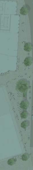
9 3 Site Analysis and Opportunities 3 Site Analysis and Opportunities Zone A includes the western edge of Canada Water Dock. The Dock has a strong connection with the identity of the area. The western Dock edge provides a pedestrian connection to Canada Water Station from the south. Improving the public realm around the Dock edge will celebrate the Dock as a public space at the heart of the proposed Town Centre. The existing former Dock Office and garden are locally important to the areas heritage. Enhancing the garden will help improve the buildings setting and integrate the existing asset with the Development. Improving accessibility, connectivity and usability of the public realm will help to improve the existing assets. Reusing historic materials and existing high quality trees will embed the Development in its surroundings and enhance the areas character. fig.3 Canada Water Dock - Existing asset. fig.4 Former Dock Office Courtyard - Unsuitable access ramp fig.5 Western Dock edge - Unsuitable cobbled surface for primary pedestrian route. fig.6 Former Dock Office car park - Poor relationship between the former Dock Offices and surrounding landscape. 8 CANADA WATER Zone A Public Realm Strategy / Public Realm Design and Access Statement / April 2018

 Petrol Filling Station Office Former Dock Office Landale House Surrey Quays Shopping Centre Car Park Courthorpe")
10 LOWER ROAD 3 Site Analysis and Opportunities 3.1 EXISTING SITE USES The primary use within Zone A is currently surface car parking. The petrol filling station and Former Dock Office are the only buildings present. Pedestrian movement is not clearly defined and much of the site is dominated by traffic accessing the petrol filling station and car park. Zone A Planning Application Boundary (Detailed Proposal) Petrol Filling Station Office Former Dock Office Landale House Surrey Quays Shopping Centre Car Park Courthorpe House HOTHFIELD PLACE DEAL PORTERS WAY Canada Water Dock 9 CANADA WATER Zone A Public Realm Strategy / Public Realm Design and Access Statement / April 2018


11 3 Site Analysis and Opportunities 3.2 EXISTING SITE VEGETATION The existing vegetation in Zone A is made up of street trees, low level shrubs and overgrown areas of vegetation. The trees which provide the highest amenity value are located in the Former Dock Office garden and the street trees along Surrey Quays Road. An avenue of cherry trees lines the western edge of the Dock providing amenity value with spring colour. These trees are however starting to fail due to growing in small tree pits. The western boundary of Zone A has become overgrown with vegetation on steep banks adjacent to residential properties. Further information on the existing site vegetation can be found in the Arboricultural Survey. fig.9 Lime tree within Former Dock Office Garden fig.10 London plane within Dock Office Garden fig.11 London plane along Surrey Quays Rd fig.12 Overgrown vegetation leading to Lower Road fig.13 Prunus spp along the western Dock Edge 10 CANADA WATER Zone A Public Realm Strategy / Public Realm Design and Access Statement / April 2018
 Former Dock Office Landale House Surrey Quays Shopping Centre Car Park")
12 LOWER ROAD 3 Site Analysis and Opportunities KEY Category Grade B (Trees of moderate quality and value) Category Grade C (Trees of low quality and value) Tree Grading Categories are based on the Arboricultural Survey prepared in accordance with BS5837:2012 Zone A Planning Application Boundary (Detailed Proposal) Former Dock Office Landale House Surrey Quays Shopping Centre Car Park Courthorpe House HOTHFIELD PLACE DEAL PORTERS WAY Canada Water Dock 11 CANADA WATER Zone A Public Realm Strategy / Public Realm Design and Access Statement / April 2018


13 3 Site Analysis and Opportunities 3.3 EXISTING SITE LEVELS The majority of Zone A is comprised of the Surrey Quays Shopping Centre car park and so is relatively flat. Between Deal Porters Way and Lower Road is a significant level change of around 4m. Retaining walls and areas of overgrown planting form the western boundaries adjacent to Landale House, Courthorpe House and Hothfield Place. The Former Dock Office is surrounded to the east by retaining walls containing large mature trees. A small retaining wall steps from Deal Porters Way to the western edge of Canada Water Dock. Existing site levels adjacent to Surrey Quays Road Existing site levels around Former Dock Offices Retaining wall between Hothfield Place and Deal Porters Way Retaining wall along western edge of Canada Water Dock. 12 CANADA WATER Zone A Public Realm Strategy / Public Realm Design and Access Statement / April 2018


14 3 Site Analysis and Opportunities fig.14 Existing levels AOD (Above Ordinance Datum) KEY +5-6m AOD +4-5m AOD +3-4m AOD +2-3m AOD +1-2m AOD RETAINING WALL Zone A Planning Application Boundary (Detailed Proposal) Former Dock Office Landale House +4.1 Surrey Quays Shopping Centre Car Park LOWER ROAD Petrol Station Courthorpe House HOTHFIELD PLACE DEAL PORTERS WAY Canada Water Dock 13 CANADA WATER Zone A Public Realm Strategy / Public Realm Design and Access Statement / April 2018
 and one of two Green Links (Heritage Link).")

15 3 Site Analysis and Opportunities 3.4 MASTERPLAN CONTEXT Zone A is located on the axis of two key routes established by the Canada Water Masterplan: the High Street (Deal Porters Way) and one of two Green Links (Heritage Link). The High Street is the primary north-south connection linking Canada Water Station with Surrey Quays Station to the south. It is also the primary retail spine within the masterplan connecting Surrey Quays Road with Lower Road. The Heritage Link is part of a wider strategy of green links through the masterplan connecting Russia Dock Woodland and Southwark Park. New public spaces provided within Zone A will complement a series of key public spaces within the Canada Water Masterplan. The design of the spaces within Zone A will help establish the civic character of the existing and proposed buildings. Please refer to Canada Water Masterplan - Design and Access Statement - Volume II: Public Realm for further details on the strategic principles of the Masterplan. 14 CANADA WATER Zone A Public Realm Strategy / Public Realm Design and Access Statement / April 2018


16 3 Site Analysis and Opportunities Heritage Link High Street Heritage Link Community Link fig.15 Key links through the masterplan fig.16 Key public spaces and secondary spaces in the masterplan Green Links Dock Link High street Key public spaces Secondary spaces 15 CANADA WATER Zone A Public Realm Strategy / Public Realm Design and Access Statement / April 2018

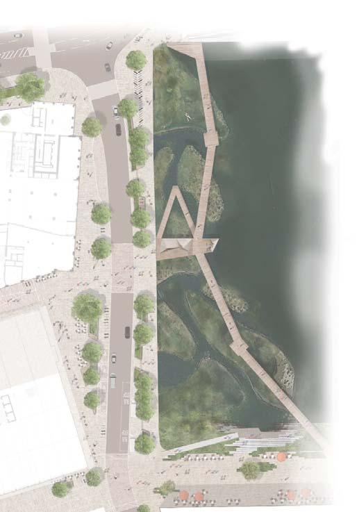
17 4 The Proposal 4 The Proposal 4.1 LANDSCAPE AREAS The design of Zone A creates the opportunity for multiple differentiated spaces, each with a distinctive and unique feel and identity. The following section describes each of these spaces in greater detail. KEY Western Dock Edge Dock Office Garden Community Square Dock Office Walk Surrey Quays Road Zone A Planning Application Boundary (Detailed Proposal) SURREY QUAYS ROAD Dock Office Garden A1 LOWER ROAD Square Dock Office Walk Community A2 DEAL PORTER WAY Canada Water Dock fig.17 Illustrative plan showing landscape character areas. 16 CANADA WATER Zone A Public Realm Strategy / Public Realm Design and Access Statement / April 2018

18 4 The Proposal King George s Field SURREY QUAYS ROAD LOWER ROAD Former Dock Office A1 A2 DEAL PORTER WAY Canada Water Dock fig.18 Illustrative sketch showing public realm interacting with the building uses 17 CANADA WATER Zone A Public Realm Strategy / Public Realm Design and Access Statement / April 2018


19 4 The Proposal A1 A WESTERN DOCK EDGE Zone A includes the western edge of the Canada Water Dock. Public space adjacent to the Dock Edge encourages people to stop and enjoy views of the Dock. Pocket spaces of seating amongst planting are set back from the main path to provide comfortable spots for people to sit and rest. Tree planting provides a green canopy around seating areas, enhancing their comfort and attractiveness. Raised crossings aid pedestrian movement across Deal Porters Way, promoting safety and a high quality pedestrian experience. PLOT A1 6 Along the western footpath of Deal Porters Way, pocket spaces enclosed by planting create the opportunity for cafe seating adjacent to building frontages, associated with the retail units of Plots A1 and A2 PLOT A KEY 1. Raised crossing 2. Possible zone for outdoor seating 3. Service bay and coach drop-off 4. Disabled parking bay 5. Possible location for bus stop 6. Soft planting Proposed cycle parking Existing cycle parking to be replaced Proposed tree planting Western Dock Edge Boundary 1 fig.19 Western Dock Edge Illustrative plan 0 10m 20m Example of outdoor seating associated with the building uses 18 CANADA WATER Zone A Public Realm Strategy / Public Realm Design and Access Statement / April 2018


20 4 The Proposal Example of soft planting Example of seating edge 19 CANADA WATER Zone A Public Realm Strategy / Public Realm Design and Access Statement / April 2018

21 4 The Proposal fig.20 View north towards Canada Water library 20 CANADA WATER Zone A Public Realm Strategy / Public Realm Design and Access Statement / April 2018

22 21 CANADA WATER Zone A Public Realm Strategy / Public Realm Design and Access Statement / April The Proposal

23 4 The Proposal DOCK OFFICE GARDEN The Dock Office Garden will be remodelled to provide a quiet, verdant public space characterised by several mature existing trees that provide scale and structure. This space will provide an informal place to sit with amenities such as planting and decking beneath the trees to create an attractive setting. There is also the opportunity for an outdoor dining area linked with the building uses of Plots A1 and A2. A raised area of planting and existing mature trees divides the courtyard space from the hub of activity around the community square. Terraces of planting form an attractive backdrop, where cafe tables are placed beneath the trees. A1 A2 4 KEY Former Dock Office Planted terraces 2. Existing mature trees to be retained 3. Specimen multi-stem tree 4. Outdoor seating 5. Proposed accessible slope Cycle stands Dock Office Garden Boundary 2 5 fig.21 Dock Office Garden - Illustrative plan 0 10m 20m 22 CANADA WATER Zone A Public Realm Strategy / Public Realm Design and Access Statement / April 2018


24 4 The Proposal Outdoor seating area associated with soft planting Examples of outdoor seating area beneath mature trees 23 CANADA WATER Zone A Public Realm Strategy / Public Realm Design and Access Statement / April 2018

25 4 The Proposal fig.22 View towards the leisure centre from the Dock Office Garden 24 CANADA WATER Zone A Public Realm Strategy / Public Realm Design and Access Statement / April 2018

26 25 CANADA WATER Zone A Public Realm Strategy / Public Realm Design and Access Statement / April The Proposal


27 4 The Proposal Remodelling of the existing levels will help unify the space and the surrounding buildings, providing inclusive access to the courtyard. The proposed level change with a series of slopes no steeper than 1in 21 will allow an easy, pleasurable and intuitive movement between the proposed Community Square, the Dock Office Garden and Surrey Quays Road. improving its setting in the landscape has been developed. The proposal enhances access for all and opens up areas at the lower level for play and outdoor dining. A series of terraced retaining walls protects the existing trees and helps divide up the space, whilst creating a green backdrop and canopy. A levels strategy which retains the high quality mature trees and celebrates the former Dock Offices by fig.23 Existing levels - Existing accessible entrance routes fig.24 Proposed levels - Proposed accessible entrance routes KEY 1. Former dock offices 2. Courtyard Existing accessible entrance routes KEY 1. Former Dock Offices 2. Courtyard 3. Planted terraces 4. Community Square Proposed accessible entrance routes 26 CANADA WATER Zone A Public Realm Strategy / Public Realm Design and Access Statement / April 2018


28 4 The Proposal fig.25 Approach from Surrey Quays Road to Dock Office Garden Corten retaining elements fig.26 Terraced planting area with brick and corten retaining elements Examples of brick wall 27 CANADA WATER Zone A Public Realm Strategy / Public Realm Design and Access Statement / April 2018

29 4 The Proposal COMMUNITY SQUARE A1 A2 The Community Square is set back from Deal Porters Way and provides a flexible space to be used by the local community. At the southern edge of the square is the main entrance to the proposed leisure centre. The square has the potential to be programmed as an extension of the leisure centre and is capable of hosting community events, fitness classes, yoga etc. There is a considerable existing level change in the square. A sunken amphitheatre reveals the former Dock Offices and provides an engaging public space to be used for performances, events and children s play. A large specimen tree provides a focal point and a green canopy to sit beneath. 0 5m 10m Former Dock Office 2 6 Plot A1 KEY 1. Square - flexible space 2. Sunken amphitheatre 3. Specimen tree 4. Steps 5. Sitting steps 6. Raised edge Cycle stands Community Square Boundary Proposed Leisure Centre Entrance 4 Plot A2 fig.27 Community Square - Illustrative plan 28 CANADA WATER Zone A Public Realm Strategy / Public Realm Design and Access Statement / April 2018


30 4 The Proposal Plot A1 Former Dock Office A B Plot A2 Proposed Leisure Centre Entrance fig.28 Dock Office Garden and Community Square Fitness Meet COMMUNITY SQUARE USES: A: Sunken amphitheatre able to host temporary play activities, small cinema.. Community feeling EVENTS B: Flexible space for events, street markets, temporary sport activities relating to the leisure centre. Street Food Play Suggested temporary activities 29 CANADA WATER Zone A Public Realm Strategy / Public Realm Design and Access Statement / April 2018


31 4 The Proposal fig.29 View west into the community square Example of brick stair fig.30 The brick steps of the sunken amphitheatre provide a place to sit, spectate and perform in the square Example of brick wall 30 CANADA WATER Zone A Public Realm Strategy / Public Realm Design and Access Statement / April 2018


32 4 The Proposal fig.31 View towards the community square, steps link the A2 building level with the square and offer the opportunities to sit and rest. Examples of steps 31 CANADA WATER Zone A Public Realm Strategy / Public Realm Design and Access Statement / April 2018

33 4 The Proposal DOCK OFFICE WALK The Dock Office Walk introduces a new connection for pedestrians and cyclists between the Development, Lower Road and Southwark Park. A1 The route encourages play using coloured asphalt with graphics and a continuous timber element for climbing and balancing. A2 Extensive areas of cycle parking are provided adjacent to the leisure centre entrance to respond to cycle parking requirements for Plot A m 20m LOWER ROAD PLOT A2 fig.32 Dock Office Walk - Illustrative plan KEY 1. Cycle and pedestrian route 2. Continuous timber play element Cycle parking Dock Office Boundary 32 CANADA WATER Zone A Public Realm Strategy / Public Realm Design and Access Statement / April 2018


34 4 The Proposal fig.33 Dock Office Walk sketch view with example of coloured surfacing with graphics Example of informal playable space within a street Example of pedestrian street with associated soft planting 33 CANADA WATER Zone A Public Realm Strategy / Public Realm Design and Access Statement / April 2018

35 4 The Proposal SURREY QUAYS ROAD Surrey Quays Road is an existing street providing key vehicular access. The design considers the existing and proposed pedestrian routes and the circulation for the building entrances, providing clear routes. The existing trees will be retained to maintain the character of the streetscape. A1 A2 Extensive areas of cycle parking are provided adjacent to the building entrances to respond to cycle parking requirements for Plot A m 20m SURREY QUAYS ROAD PLOT A1 fig.34 Surrey Quays Road - Illustrative plan KEY 1. Raised planter with existing trees 2. Service entrance Cycle parking Surrey Quays Road Boundary 34 CANADA WATER Zone A Public Realm Strategy / Public Realm Design and Access Statement / April 2018


36 4 The Proposal m m m m m fig.35 View east along Surrey Quays Road Building entrances Examples of stair and secondary route to allow access to the building 35 CANADA WATER Zone A Public Realm Strategy / Public Realm Design and Access Statement / April 2018
37 4 The Proposal 4.2 PROPOSED LAND USES AND FRONTAGES The proposed ground floor uses and active frontages of Plots A1 and A2 have been integrated with the Public Realm design to ensure an active ground floor and engaging public realm experience. Entrances to the proposed Leisure centre and Plot A1 retail active the edges of the community square. Retail and office reception space active the pedestrian experience along the western side of Deal Porter Way. 36 CANADA WATER Zone A Public Realm Strategy / Public Realm Design and Access Statement / April 2018


38 4 The Proposal SURREY QUAYS ROAD A1 LOWER ROAD Dock Office Walk Community Square A2 DEAL PORTERS WAY fig.36 Ground floor uses KEY RETAIL LEISURE CENTRE RECEPTION SERVICE AREA BIKE HUB OTHER SURREY QUAYS ROAD A1 LOWER ROAD Dock Office Walk Community Square A2 DEAL PORTERS WAY fig.37 Building frontage - Active and passive KEY ACTIVE PASSIVE 37 CANADA WATER Zone A Public Realm Strategy / Public Realm Design and Access Statement / April 2018
39 4 The Proposal 4.3 PLAY STRATEGY This play strategy sets out how the Development will give proper recognition of children and young people s needs and wish for play and recreation. The key principles are multi- functionality, design quality, permeability, and effective, sensitive management and maintenance. The aim is to create a Public Realm that is genuinely child-friendly and inclusive, in line with the aspirations set out in the Mayor of London s London Plan: to ensure that all children have safe access to good quality, welldesigned, secure and stimulating play and informal recreation provision (Policy 3.6 Children and Young People s Play and Informal Recreation Facilities). The play strategy has been developed as part of the overall Canada Water Masterplan Public Realm Strategy and also takes into consideration existing play spaces and sports areas within the vicinity of the Masterplan. The proposals allows for sufficient publicly accessible open space to meet the benchmark of 10 sqm of playable space per child set out in the Mayor s Supplementary Planning Guidance on play. In keeping with this Guidance, the vision is that as much of the public realm as possible will be in the form of what it calls `playable space : space where children s play and recreation is one legitimate use amongst a range of uses without compromising other residents and users needs and enjoyment. Play facilities will not be segregated and fenced-off. Instead, playful offers will be threaded throughout the public realm, including distinctive focus points such as play equipment set in engaging landscaping, open space and facilities for games and wheeled activities, and incidental features that encourage children to play. Different age groups should be able to make use of the spaces through varying activities at different times of the day. Carefully selected play equipment, facilities and nonprescriptive features such as changes of level, hard and soft landscaping, and other landscape features will create playful offers that merge into the wider open space, encouraging a wide range of play activities while also allowing the space to be enjoyed by adults. The following age ranges are based on the categories within Shaping Neighbourhoods: Play and Informal Recreation SPG children x 10 sq m = 130 sq m play space Playable Space for under 5s: Playable space required: 80m 2 Playable space provided: 80m 2 Playable Space for children 5-11 year olds: Playable space required: 30m2 Playable space provided: 180m2 Doorstep play Local & neighbourhood play Youth play Playable Space for young people 12+: Playable space required: 20m2 Playable space provided: 290m2 8 children = 80 sq m play space 3 children = 30 sq m play space 2 children = 20 sq m play space 38 CANADA WATER Zone A Public Realm Strategy / Public Realm Design and Access Statement / April 2018

.")

40 4 The Proposal fig.38 Schematic location of play spaces PLAY AREAS Play area for children under 5s Play area for children 5-11 year olds Play area for young people 12+ Plot A1 Level 6 roof terrace (Not publicly accessible). See Plot A1 Design and Access Statement for further details. Example of playable edge Example of painted games Example of temporary play equipments 39 CANADA WATER Zone A Public Realm Strategy / Public Realm Design and Access Statement / April 2018
41 4 The Proposal 4.4 PROPOSED VEHICULAR MOVEMENT AND SERVICING A clear hierarchy of vehicular and pedestrian desire lines allows for legible and intuitive movement through the Site. A new strategic connection is created to link Canada Water to Lower Road and Southwark Park. The pedestrian experience is improved along the western Dock edge, a key pedestrian route to Canada Water station. Vehicular movement is limited to Deal Porters Way and Surrey Quays Road. Only fire vehicles are permitted to use Dock Office Walk access. Servicing access to the buildings is made away from the main public spaces on Surrey Quays road and to the south of Plot A2. 40 CANADA WATER Zone A Public Realm Strategy / Public Realm Design and Access Statement / April 2018

42 4 The Proposal SURREY QUAYS ROAD LOWER ROAD A1 Dock Office Walk Community Square A2 DEAL PORTERS WAY fig.39 Pedestrian movement KEY PEDESTRIAN MOVEMENT SECONDARY PEDESTRIAN ROUTE THROUGH PLOT A1 SURREY QUAYS ROAD Existing cycle parking LOWER ROAD A1 Dock Office Walk Community Square A2 DEAL PORTERS WAY KEY fig.40 Vehicular movement VEHICULAR MOVEMENT FIRE SERVICE ROUTE SERVICE ACCESS ROUTE COACH AND LOADING BAY CYCLE PARKING EXISTING CYCLE PARKING DISABLED CAR PARK BUS STOP 41 CANADA WATER Zone A Public Realm Strategy / Public Realm Design and Access Statement / April 2018
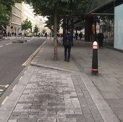
43 4 The Proposal 4.5 SURFACE FINISHES The surface finishes proposals have been coordinated as part of the Canada Water Masterplan - Design and Access Statement - Volume II: Public Realm, and adhere to the following principles. The quality of the Public Realm is derived from simplicity through the selection of a restrained palette of complementary materials and simple coordinated details. The aim is to create a cohesive, coordinated palette of hard landscape materials which are easy to use, maintain, and control. The proposal uses surface finishes to create hierarchy, sense of place and legibility through the varied landscape areas. Warm colour tones have been selected to create a comfortable environment. In particular, Deal Porters Way and Surrey Quays Road will be paved (in accordance with Canada Water High Quality Paving Palette) with natural stone in pedestrian and shared areas. Natural stone finishes with appropriate size and texture (plank pavers or setts) and warm colours are proposed to reinforce the character of this area and provide a high quality finish along the Dock. Surface Treatments The design and construction of the Public Realm will follow the principles as set out below: Be restrained in the use of colour and texture. Be robust enough to withstand the location and the anticipated amount and type of use for the area. Ensure street furniture, tree pits/grilles, manhole covers and gullies are at right angles to the direction of the paving units to avoid awkward cuts and junctions. Ensure that manholes and inspection covers are concealed with recessed access covers and filled with the same material as the surrounding areas. Avoid bright colours for cycle lane surfaces and markings. It is proposed that details of the surface finishes to be used throughout the Zone A public realm will be submitted for approval pursuant to a planning condition. The Dock Office Garden and Community Square are characterised by clay paving (in accordance with Canada Water Clay/Brick Paving Palette) to reinforce the heritage of the Site and the former Dock Offices. Varied textures are proposed to create subtle variations between these two areas without losing uniformity through Zone A. The Dock Office Walk will be surfaced with coloured, the proposal is to include a range of graphics (including numbers and numerical games, adventure and sport trails) to encourage play and sport along this route. Carriageways and service areas will be surfaced in asphalt. 42 CANADA WATER Zone A Public Realm Strategy / Public Realm Design and Access Statement / April 2018


44 4 The Proposal fig.41 Illustrative surface finishes plan Clay Paving Type 1 Clay Paving Type 2 Bullnose Dock Edge Granite service bays and raised table Granite plank pavers or Granite Sett paving Graphic/coloured surfacing Asphalt Permeable Resin Bound 43 CANADA WATER Zone A Public Realm Strategy / Public Realm Design and Access Statement / April 2018
45 4 The Proposal 4.6 LEVELS Regrading of Zone A levels allows for improved accessibility across the Site as well as improving the setting of existing assets such as high quality mature trees where possible and the former Dock Offices. The strategy aims to tie into existing levels around the perimeter to create inclusive access through the site and to new building frontages for all. 44 CANADA WATER Zone A Public Realm Strategy / Public Realm Design and Access Statement / April 2018


46 4 The Proposal fig.42 Proposed levels AOD (Above Ordinance Datum) KEY +5-6m AOD +4-5m AOD +3-4m AOD +2-3m AOD +1-2m AOD RETAINING WALL Zone A Planning Application Boundary (Detailed Proposal) in40 1in in in in CANADA WATER Zone A Public Realm Strategy / Public Realm Design and Access Statement / April 2018
47 5 Tree Planting and Vegetation 4.7 STREET FURNITURE AND FEATURES The street furniture proposals have been coordinated as part of the Canada Water Masterplan Public Realm Strategy, and adhere to the following principles. Street furniture is an important element in creating a sense of place and a legible Public Realm and includes, amongst others: benches, bollards, litter bins, street lighting, traffic lights, traffic signs and bus stops. The proposal responds to the varied landscape character areas, with different street furniture to create hierarchy, sense of place and legibility through Zone A. Warm colour tones have been selected to create a comfortable environment. Deal Porters Way is characterised by raised planters with a large seating edge in natural stone that is visually related with the existing bullnose Dock Edge. The proposal responds to the cycle space Requirement (based on London Plan (2016) Standard) providing short-stay cycle stands within the Public Realm. Short-stay Requirement - A1 Building: Cycle spaces required: 44 Cycle spaces provided: 44 Cycle stands* provided: 22 Short-stay Requirement - A2 Building: Cycle spaces required: 112 Cycle spaces provided: 114 Cycle stands* provided: 57 * Every stands can accommodate two bikes For the Dock Office Garden and Community Square the brick walls and steps are proposed to ensure a common language of elements with the former Dock Offices and the proposed paving. Additional corten steel edges are inserted to retain the existing levels more than 1m above ground. Along the Dock Office Walk a continuous timber element is introduced for climbing and balancing. Natural material (timber) is been preferred to create an interesting informal natural play area. The design and placement of street furniture should follow the principles as set out below: Street furniture should be kept to a necessary minimum to reduce possible clutter and maintenance requirements. Ensure a simple, consistent range of materials which are robust, high quality and durable. It is proposed that details of the street furniture to be used throughout the Zone A public realm will be submitted for approval pursuant to a planning condition. 46 CANADA WATER Zone A Public Realm Strategy / Public Realm Design and Access Statement / April 2018

")


48 5 Tree Planting and Vegetatio 16no. (Existing to be reinstated) 6no. 8no. 42no. (Existing to be reinstated) 4no. 4no. 12no. 38no. 5no. 2no. fig.43 Illustrative location of the main street furniture and features Sitting edge Brick wall/steps/sitting steps Continuous timber element Movable cafe table area Corten steel retaining wall Metal cycle stands Existing cycle stands Granite steps 47 CANADA WATER Zone A Public Realm Strategy / Public Realm Design and Access Statement / April 2018

49 5 Tree Planting and Vegetation 5 Tree Planting and Soft Landscape 5.1 TREE RETENTION AND ENHANCEMENT STRATEGY The trees strategy aims to retain and enhance existing trees which are providing amenity value where possible. Enhancing the setting of the high quality trees will benefit the Development by embedding the new buildings within their context. Mature trees will help to creating green streets and add to the character of the new public spaces created. Tree maintenance of existing specimens will improve views and improve tree health. Areas of vegetation along the proposed Dock Office Walk are to be cleared and regraded to create a new connection to Lower Road. The existing trees in the Dock Office Garden contribute to the character of the space beneath their canopy and the design of the public spaces here has developed to enhance the setting of the mature trees in this area. SURREY QUAYS ROAD KEY Category Grade B (Trees of moderate quality and value) Dock Office Walk Community Square DEAL PORTERS WAY Category Grade C (Trees of low quality and value) Tree Grading Categories are based on the Arboricultural Survey prepared in accordance with BS5837:2012 fig.44 Existing trees - Category 48 CANADA WATER Zone A Public Realm Strategy / Public Realm Design and Access Statement / April 2018


50 5 Tree Planting and Vegetatio SURREY QUAYS ROAD Dock Office Walk Community Square DEAL PORTERS WAY KEY Trees to be removed Trees to be retained Root protection area fig.45 Retained trees SURREY QUAYS ROAD A1 Dock Office Walk Community Square A2 DEAL PORTERS WAY KEY Trees to be retained Proposed trees Root protection area fig.46 Retained and proposed trees 49 CANADA WATER Zone A Public Realm Strategy / Public Realm Design and Access Statement / April 2018
51 5 Tree Planting and Vegetation 5.2 PROPOSED TREE PLANTING The tree planting proposals should be read in conjunction with the Canada Water Masterplan Public Realm Strategy and the Arboriculture Survey Report and Arboricultural Impact Assessment. Betula spp. is proposed for the Dock Office Walk to create seasonal interest with varied structure, texture and colour and encourages people to stay and play along this route. Tree planting within an urban context can be used to unify spaces and routes, frame views and highlight desire lines and focal points. Trees can provide shelter from wind and rain, buffer noise and pollution and create shade. Consideration has been given to the placement of utilities to ensure successful tree planting. Trees adjacent to the highway must have a minimum clear stem of 2.5m. Zone A is an important piece of the Heritage Link as a trail promoting the history of the Site. Planting can contribute to telling the story of the use of timber and paper-making at Canada Water. The proposal responds to this aim, with varied tree planting to create a distinct sense of place and an attractive setting through Zone A. See Masterplan Public Realm Design and Access statement for further details of the strategic links. In particular, the Dock Edge is characterised by Liriodendron tulipifera to replace the existing Prunus spp. which are reaching the end of their life span. The trees have been selected to give a strong edge and scale to the Dock Edge. The trees flower in summer which will provide an attractive amenity. Quercus spp. is proposed as a key tree to reinforce junctions creating focal elements used for way finding within the Community Square and Deal Porters Way. Populus balsamica completes the streetscape along the Deal Porters Way and helps improving the local biodiversity. 50 CANADA WATER Zone A Public Realm Strategy / Public Realm Design and Access Statement / April 2018


52 5 Tree Planting and Vegetatio fig.47 Proposed schematic tree planting plan Existing trees Betula pendula Betula pubescens Betula jacquemontii Betula papyrifera Liriodendron tulipifera Populus balsamifera Quercus rubra Quercus coccinea Quercus palustris 51 CANADA WATER Zone A Public Realm Strategy / Public Realm Design and Access Statement / April 2018
53 5 Tree Planting and Vegetation 5.3 SOFT LANDSCAPE Planting will be used to create visually interesting areas throughout the year, within the public spaces of the Development. The proposal responds to the varied landscape character areas with different planting to create hierarchy, sense of place and seasonal interest through Zone A. In particular the Dock Office Garden is characterised by lush plants with a mix of perennials, bulbs, fern and grasses that can grow in shade. The theme of the planting will be large foliage plants to provide interest through texture. The Western Dock Edge will be planted with a carpet of herbaceous planting that will provide injections of colour throughout the seasons. Varied planting will allow a prolonged flowering season and planting fruit and nectar rich species will provide food for birds and insects (and in turn food for bats). The form and structure of the planting will also create sheltered nesting opportunities for birds. The Dock Office Walk is characterised by a mix of grasses and herbaceous plant with specific attention to create a sensory garden that offers opportunities to play for young children. The proposal for Surrey Quays Road will respond to the specific soil and light condition due to the existing trees. A mix of perennials and grasses will provide an interesting setting along the street. A retaining structure of planted gabions forms the western boundary of Plot A2. See Plot A2 Design and Access Statement for more details. It is proposed that details of the species and planting proposals for Zone A will be submitted for approval pursuant to a planning condition 52 CANADA WATER Zone A Public Realm Strategy / Public Realm Design and Access Statement / April 2018


54 5 Tree Planting and Vegetatio fig.48 Proposed schematic soft planting plan Dock Office Garden Western Dock Edge Dock Office Walk Surrey Quays Road Green wall 53 CANADA WATER Zone A Public Realm Strategy / Public Realm Design and Access Statement / April 2018
55 6 SUDs Strategy 6 SUDs Strategy An important concept in the approach to the design of the spaces across the Development is the opportunity to incorporate sustainable urban drainage systems (SUDS) into the proposed planting as a visual element within the landscape. Key to this approach is to make the water cycle visible utilising design features that show how water moves through the landscape. From a technical consideration this helps to mitigate increased run-off from hard surfaces entering the sewer system. From a social consideration it helps connect people to their surrounding environment. The proposed Public Realm provides areas of planted beds to attenuate rainfall, and on warmer days encourages evapotranspiration. The majority of the hard surfaces are to be drained towards planting areas or rills for receiving runoff which will capture and allow water to slowly permeate into the ground. Water attenuated within the catchment area will be discharged into the Dock helping to raise the water level benefiting wetland habitat creation. A number of ways to manage the run-off water on the Site are identified within the landscape proposals, these include: Rain gardens proposed to attenuate surface water run off. Rills and channels to pick up water from hard surfacing. Attenuated water discharged into Canada Water Dock. 54 CANADA WATER Zone A Public Realm Strategy / Public Realm Design and Access Statement / April 2018
 KEY Rain")

56 6 SUDs Strategy fig.49 Schematic location of Sustainable Urban Drainage Systems (SUDS) KEY Rain garden Tree Pit Storage Discharge into Canada Water Dock Attenuation tanks Tree Pit Storage Example of rain garden 55 CANADA WATER Zone A Public Realm Strategy / Public Realm Design and Access Statement / April 2018
57 7 Landscape Management and Maintenance 7 Landscape Management and Maintenance Appropriate public realm management and maintenance is vital to the success of the public realm. Even the best-designed spaces need to be cared for and inappropriate behaviour needs an effective response. The designs will foster perceptions of safety and a degree of self-regulation of behaviour through encouraging active, positive uses by a diverse mix of users. The management of the public realm will be undertaken by Broadgate Estates as part of general management of the whole Development. The following key factors will need to be addressed in order to sustain a high quality public realm: Cleanliness Repair and Replacement Horticultural Health Safety and Security Cleanliness Cleanliness is the principle indication of the quality of management of the public realm. As such, the perceived success of the Development will be significantly affected by the effectiveness of the procedures established for regular pavement cleaning, litter picking, and the removal of graffiti, bill posters and chewing gum. The strategy will be applied to all elements of the scheme including roads, pedestrian paving, street furniture, drains and planting beds. Repair and Replacement The need for repair and replacement of finishes will be mitigated by the use of appropriate and durable materials. Nevertheless, in the long term a degree of maintenance and replacement is unavoidable. In order to ensure that the public realm remains safe and in good condition, all worn-out, damaged and broken elements will be promptly repaired or replaced. In the short term this will be carried out within the clearly defined defects liability periods of the various contractors who will install the works. The longer term solution will form part of the management plan. Vigilant and regular monitoring of every aspect of the scheme will ensure that all remedial work is carried out in a timely and thorough fashion. Horticultural Heath: The health and general condition of planted areas including trees, shrubs, perennial plants and lawns is clearly indicative of the level of care and attention a place receives. Planting, including any replacements to dead or dying material, will be maintained in accordance with a Landscape Maintenance Specification. 56 CANADA WATER Zone A Public Realm Strategy / Public Realm Design and Access Statement / April 2018
58 7 Landscape Management and Maintenance Safety and security. A safe environment is one that is accessible to all. As well as adopting Secured by design principles, in the design of the streets and spaces, long term management and maintenance of the Development will be required. Design of the public realm will consider the principles of Secured by Design, as well as the desire for a welcoming, open, and accessible public environment. Well-used and well-looked after spaces are less likely to suffer from crime due, therefore long term management, maintenance and a strategy for activating the public realm will be key to making these spaces safe. Well looked after places are less likely to suffer from crime, due to their popularity and therefore increased usage. A well designed public realm can contribute significantly to the quality of the built environment and play a key role in the creation of sustainable, inclusive, mixed communities. 57 CANADA WATER Zone A Public Realm Strategy / Public Realm Design and Access Statement / April 2018
59 8 Security Strategy 8 Security Strategy H This section is a summary of the security strategy prepared by QCIC Limited in consultation with the Metropolitan Police Security Design Advisors. The level of perceived security in the built environment is based on a number of factors that provide reassurance to the population that the public realm as well as individual buildings are managed and supported by conditioning of street management and routing. The intention is that the Development is privately managed, however it is a key principle that the Development is seen to integrate seamlessly into its surrounding environments. The streetscape should provide: Natural surveillance Natural access control Defensible space in residential areas Support maintenance and operational activities The masterplan security strategy sets out three distinct security areas which will require varying degrees of management according to their predominant land uses. Zone A is situated within the Town Centre Character Area. The Town Centre including the area around the Dock - Predominantly retail, leisure and public amenities at lower levels and commercial office space at upper levels. The area around the Dock is principally leisure, food and beverage, and ecology. This also provides one of the primary pedestrian routes into the site. 58 CANADA WATER Zone A Public Realm Strategy / Public Realm Design and Access Statement / April 2018


60 8 Security Strategy KEY Town Centre Central Cluster Park Neighbourhood Park Neighbourhood ZONE A Town Centre Central Cluster fig.50 Character Areas 59 CANADA WATER Zone A Public Realm Strategy / Public Realm Design and Access Statement / April 2018
61 8 Security Strategy Site Access The intention is for the Development to be highly permeable and to integrate seamlessly with its surrounding environment rather than creating an island site. Consequently, there is no intention to provide any kind of enforceable perimeter from either a pedestrian or vehicles access perspective. The vehicle access into the emerging High Street is intended to be restricted to: Buses Waste management Deliveries Licensed Taxis Emergency vehicles. Enforcement is planned to be by use of CCTV with Automatic Number Plate Recognition (ANPR) to alert the Masterplan Security Team. Mitigating Vulnerabilities There are seven main elements which have been integral to the design of the Zone A public realm that can reduce vulnerabilities and consequently strengthen resistance to threats whilst assisting in providing safe and secure spaces, they are: Access and Movement places that are well designed for movement of traffic (people and/or vehicles), in all anticipated periods of occupancy. This includes the provision of defined routes and signage which prevents inadvertent access into controlled or high risk spaces. Structure places that are designed to provide separation between different users, thus preventing conflict. Surveillance places that provide good natural sight lines where people and activity can see and be seen. This will go a long way to dissuading antisocial activity. The use of CCTV can enhance surveillance but the area of coverage must be maintained. Ownership places that define boundaries and promote a sense of community, ownership and responsibility. This will enhance the feeling of a safe and secure area. Physical Protection places that provide necessary and well-designed security features commensurate with requirement. 60 CANADA WATER Zone A Public Realm Strategy / Public Realm Design and Access Statement / April 2018
62 8 Security Strategy Activity places that cater for the anticipated level of human activity which will enhance the deterrence of crime. Management and Maintenance places that create opportunity for and ease of maintenance and management. Places that are poorly maintained will defer back to areas of increased crime and poverty. Risk Mitigation Strategy Having established the threats to the development and analysed the risks to people and property the following mitigation measures are recommended by QCIC depending on the level of threat. Quick Police response Prior event planning Appropriate lighting CCTV Security patrols Passive surveillance Limit secluded area Local Vigilance Provide Anti-vehicle measures These mitigation measures will be further assessed and implemented during the further detailed design of the Zone A Public Realm. It is proposed that details of the security measures for Zone A will be submitted for approval pursuant to a planning condition. 61 CANADA WATER Zone A Public Realm Strategy / Public Realm Design and Access Statement / April 2018
63 9 Public Realm Lighting 9 Public Realm Lighting The following lighting strategy for Canada Water Zone A has been prepared by Speirs + Major for British Land Company PLC. The strategy aims to outline key lighting design objectives and principles for the public realm of Zone A. The lighting will be designed to be compliant with the relevant standards set out in the British Standards BS and CIBSE/SSL LG6. Throughout Canada Water, the public realm lighting will be a high quality white with high colour rendering (RA value >60) to ensure maintained illuminance levels can be reduced as described in the S/P ratio table in BS LIGHTING VISION The strategy follows the principles set out in the overarching Lighting Vision report for The Development. The vision established the following key objectives explicitly related to Zone A: Consider the lit character and ambience of the public space. Light will help accentuate the unique character of Canada Water. Considered illumination will allow distinctions between the various open spaces, and routes to become visible after dark. The lighting to Zone A aims to be more calm and intimate; in support of the quiet gardens, green areas in the Western Dock and viewing points at the water s edge. Prioritise lighting for pedestrians Two essential routes intersect within Zone A; The High-street (Deal Porters Way) and The Green Link (Heritage Link). The lighting aims to encourage pedestrian movement through the Site by providing adequate illumination on a human scale. With heavy vehicle traffic such as buses travelling through the high-street, crossing points are raised to support pedestrian movement and accentuate these conflict zones between pedestrians and traffic. The lighting in these areas aims to help reduce risks by increasing illuminance levels, improving uniformity and providing adequate vertical illumination. Sufficient vertical light is vital to ensure drivers can better see pedestrians. Reveal and interpret the heritage of the Site The lighting vision promotes celebration of the maritime and industrial legacy of Canada Water. The former Dock Offices presents itself as an opportunity for architectural illumination. Subtle and gentle lighting to its facade will also create a positive backdrop for the Dock Office Gardens and contribute to the after-dark ambience of the public realm. Enhance legibility through the illumination of vertical surfaces Vertical illumination can aid pedestrian movement by creating positive vistas and a legible environment. Producing a legible space after dark is essential to help avoid people feeling lost or disorientated. For example, lighting to the entrance of the leisure centre will emphasise the entry point to the building. A lit entrance will also become a local beacon within the public realm, which is seen from the from Deal Porters Way (the emerging High Street), Surrey Quays Road (via the Gardens) and Lower Road (via Dock Office Walk) helping to draw pedestrians through the Community Square after dark. 62 CANADA WATER Zone A Public Realm Strategy / Public Realm Design and Access Statement / April 2018

 avoids the need for shallow light angles that are the primary cause of glare in street lighting.")
64 9 Public Realm Lighting Minimise spacings of lanterns to help reduce glare Modern lighting technology such as LED fixtures can potentially cause glare and therefore temporary blindness. To help reduce this glare the lighting strategy suggests in utilising lanterns with advanced optical controls and to further minimise glare, the Lighting Vision recommends decreasing the spacing between fixtures. E.g., a smaller distance between fixtures in Deal Porters Way (the emerging High Street) avoids the need for shallow light angles that are the primary cause of glare in street lighting. The use of fixtures with good optical controls will also help mitigate light trespass into the premises of Zone A. Create an on and off-peak lighting scheme by utilising smart control This strategy aims to employ the latest lighting control technology to create various lighting scenes in the hours after dark. When high numbers of people and traffic occupy the routes, lighting levels should be sufficient to aid safety. However, illumination levels can be reduced late at night when fewer people are walking over the Green Link in Zone A. Lowering light levels over the course of the evening will reduce energy consumption as well as light pollution into the night sky. Lighting accentuates the lit character of the space after dark Be sensitive towards the ecology of the Site The Western Dock Edge contains an ecologically sensitive wetland area. Here the lighting aims to balance the requirements for wildlife with perceptions of safety.this strategy seeks to illuminate the routes relatively evenly in high colour rendering to be able to lower overall light levels. Optical control of fixtures will help minimise light spillage into the wetland. As described above, the lighting control can ensure hours of darkness benefit wildlife when pedestrian use of the Dock Edge is reduced. Vertical illumination will improve legibility of the Site 63 CANADA WATER Zone A Public Realm Strategy / Public Realm Design and Access Statement / April 2018


65 9 Public Realm Lighting 9.2 LIGHTING AREAS Following the landscape design, the lighting strategy can be divided into the several lighting character areas. Western Dock Edge The design for the Western Dock Edge is divided into lighting the vehicle road, footpaths and raised crossings. Column-mounted fixtures are proposed to illuminate the road and its raised crossings evenly. Dedicated lanterns of a more human scale will illuminate the footpath and additional lighting along the western footpath will highlight the enclosed pocket seating areas to create a more intimate setting and allow passer-bys to take a moment of pause overlooking the Dock. Dock Office Garden The lighting aims to create an intimate and quiet atmosphere for the garden after dark to encourage dwelling. The strategy imagines the former Dock Offices being illuminated to celebrate the history of the Site and to create a lit backdrop for the garden. Column mounted lanterns of a human scale will provide functional illumination to the routes on either side of the space. The light spill from these lanterns will also gently illuminate the landscape. In addition, low-level lighting will be located in the landscape to emphasise the intimate ambience of the garden. Dock Office Walk Lighting columns become wayfinding markers Lanterns mounted in human scale will illuminate the walk. The design envisages the columns themselves will be gently illuminated by spill light from the lanterns to support wayfinding and emphasise the Heritage link route for pedestrians and cyclists. Additional lighting might be required to illuminate the landscape to create a positive vista into the walk when looking from Lower Road or Deal Porter s Way. The bicycle racks located against the leisure centre will require additional light for when cyclists are parking their bikes. A higher illuminance level will also contribute to the perception of security. Gently illuminated columns become features in public realm 64 CANADA WATER Zone A Public Realm Strategy / Public Realm Design and Access Statement / April 2018


66 9 Public Realm Lighting Surrey Quays Roadl Dock Office Gardenl Western Dock Edge Community Squarel Dock Office Walk fig.51 Illustrative Masterplan Visual Low level lighting to landscape emphasises open spaces Human scale lighting supports pedestrian movement 65 CANADA WATER Zone A Public Realm Strategy / Public Realm Design and Access Statement / April 2018

67 9 Public Realm Lighting fig.52 Illustrative Sketch Visual Community Square The strategy aims to illuminate the square playfully and be flexible to support the community activities on the square. The lighting will provide vertical illumination to elements such as the leisure centre entrance to support legibility and pedestrian movement through the Dock Office Walk. Changes of levels such as steps will be illuminated to a relatively higher level and will be uniform to avoid potential trip hazards. Surrey Quays Road Surrey Quays Road is an existing street that the lighting strategy aims to improve by supplementing the existing street lighting with illumination to the pathways, bicycle parking racks and steps. Additional lighting will help improve the pedestrian experience, support safety and introduce an improved sense of security. It is proposed that details of the lighting design for Zone A will be submitted for approval pursuant to a planning condition. 66 CANADA WATER Zone A Public Realm Strategy / Public Realm Design and Access Statement / April 2018
68 9 Public Realm Lighting WESTERN DOCK LIGHTING VALUES Lighting Class Illuminance EAV Uniformity Uo Vertical Illuminance Colour Temperature Colour Rendering High street CE3 15lx 0.4 A3 3000K >RA 60 Crossings CE2 20lx 0.4 A3 3000K >RA 60 Footpath n.a. 10lx n.a. n.a. 3000K >RA 80 Pockets n.a. 15lx n.a. n.a. 3000K >RA 85 DOCK OFFICE GARDEN LIGHTING VALUES Lighting Class Illuminance EAV Illuminance EMIN Vertical Illuminance Colour Temperature Colour Rendering Eastern Pathway P2 10lx 3lx A3 2700K >RA 70 Western Pathway P3 7.5lx 1.5lx A3 2700K >RA 70 Open Area n.a. 0.5lx n.a. n.a. 2700K/3000K >RA 80 CUMMUNITY SQUARE LIGHTING VALUES Lighting Class Illuminance EAV Illuminance EMIN Vertical Illuminance Colour Temperature Colour Rendering Pathway P3 7.5lx 1.5lx A3 2700K >RA 70 Steps/Ramps n.a. 30lx 15lx A3 2700K >RA 70 DOCK OFFICE WALK LIGHTING VALUES Lighting Class Illuminance EAV Illuminance EMIN Vertical Illuminance Colour Temperature Colour Rendering Pathway P3 7.5lx 1.5 lx A3 2700K >RA 70 Bicycle Racks n.a. 10lx 3lx n.a. 3000K >RA 70 SURREY QUAYS ROAD LIGTHING VALUES Lighting Class Illuminance EAV Illuminance EMIN Vertical Illuminance Colour Temperature Colour Rendering Pathway P2 10lx 3lx A3 3000K >RA 70 Bicycle Racks n.a. 10lx 3lx n.a. 3000K >RA 70 Steps/Ramps n.a. 30lx 15lx A3 3000K >RA CANADA WATER Zone A Public Realm Strategy / Public Realm Design and Access Statement / April 2018


69 10 Conclusion 10 Conclusion A commitment to delivering a high quality public realm is integral to the Canada Water masterplan. The Zone A public realm demonstrates how the public realm vision can come forward as a detailed application. This document has set out how a well designed Public Realm can contribute significantly to the quality of the built environment and play a key role in defining the image and perception of a place. The Public Realm has a key role in the creation of sustainable, inclusive, and mixed communities. The proposals illustrated in this Masterplan are based on a number of integrated principles to produce an attractive, distinctive and inclusive place that maintains and reinforces the area s character and identity. This Public Realm strategy has aimed to bring these principles together in a cohesive manner that will contribute to the overall character of the Development, integrating it within the context of Canada Water to create a lively, diverse and safe series of places where people will want to live and visit. This is in accordance with the comprehensive approach within Southwark Council s Canada Water Area Action Plan (2015). SURREY QUAYS ROAD Dock Office Walk LOWER ROAD 68 CANADA WATER Zone A Public Realm Strategy / Public Realm Design and Access Statement / April 2018


70 DEAL PORTERS WAY 10 Conclusion Dock Office Garden PLOT A1 Former Dock Office Canada Water Dock PLOT M Community Square DEAL PORTERS WAY PLOT A2 fig.53 Illustrative Zone A Public Realm plan 69 CANADA WATER Zone A Public Realm Strategy / Public Realm Design and Access Statement / April 2018
doyle + o troithigh landscape - architecture
 doyle + o troithigh landscape - architecture REPORT: PROJECT: LANDSCAPE DESIGN REPORT. STUDENT HOUSING DEVELOPMENT AT WESTWOOD HOTEL SITE. DATE: MAY 2018. www.doyle-otroithigh.com Landscape design report,
Design Guidelines Volume II Part 1 of 2 Masterplan Public Realm. May 2018 Townshend Landscape Architects
 Design Guidelines Volume II Part 1 of 2 Masterplan Public Realm May 2018 Townshend Landscape Architects date issue notes 25/01/2018 P01 Client review draft 02/03/2018 P02 Client review draft 27/03/2018
97 Lea Bridge Road, Leyton, E10 7QL London Borough of Waltham Forest December 2015
 97 Lea Bridge Road, Leyton, E10 7QL London Borough of Waltham Forest December 2015 Public Realm and Landscape Proposals LEA BRIDGE ROAD, WALTHAMSTOW Public Realm & Landscape Proposals BDP(90)RPT001 December
Section 4 - Public Realm & Landscape proposals Landscape Masterplan. Section 4 52
 - Public Realm & Landscape proposals Landscape Masterplan 52 Proposed Masterplan - Green Infrastructure Strategy District Park 4.33 Ha to provide Passive and active recreation with a large play area which
East Grove Public Realm
 H - - MP - Elephant Park Public Realm RO EY DN NEW KENT ROAD E AC PL The public realm has been designed to create an environment which is easy to move through, accessible to all, safe and playful. The
Surface Materials Strategy Reference Images
 2.0 RETAIL & HOTEL PLOTS, BRENT CROSS MAIN SQUARE THRESHOLD SPACES & ENERGY CENTRE Surface Materials Strategy Reference Images Riparian themes and patterns reflected in the paving Palette of warm granite
Chapter 2: OUTLINE PLANNING APPLICATION PROPOSALS. A New Garden Neighbourhood Matford Barton 17
 Chapter 2: OUTLINE PLANNING APPLICATION PROPOSALS A New Garden Neighbourhood Matford Barton 17 2.1. SUMMARY AND STATUS OF THE PROPOSALS 2.1.1. The parameter plans and associated wording in this chapter
Design and Access Statement Volume III Part 1 of 9 Plot A1. May 2018 Allies and Morrison
 Design and Access Statement Volume III Part 1 of 9 Plot A1 May 2018 Allies and Morrison DATE ISSUE NOTES 08/05/2018 P01 Planning issue Document control register Copyright 2018 Allies and Morrison No part
VEHICULAR AND PEDESTRIAN CIRCULATION
 This perspective sketch communicates the intended character and quality of a proposed streetscape design. Locate benches near a major intersection where people tend to gather. Seating and lighting provide
Housing Development at Balloonagh Tralee Co Kerry
 Design Statement Housing Development at Balloonagh Tralee Co Kerry Area of site 10,400m2 24 houses-12no 3 bed, 12no 2 bed and 4 single bed apartments total residential area of 2411m2 Open space provided
Background Information
 Background Information view at site entrance THE LONDON BOROUGH OF SUTTON As the strategic local authority the Council is working with a range of partners to take forward various development sites in Hackbridge.
A new park will be delivered as part of the Elephant Park regeneration.
 A new park will be delivered as part of the Elephant Park regeneration. The exhibition boards presented here introduce the first phase of the new park that is scheduled to open in spring 2017 that has
ILLUSTRATIVE MASTERPLAN
 ILLUSTRATIVE MASTERPLAN The Development Dairy Crest (Imperial College) The Proposed Development aims to create a new high quality residential neighbourhood, alongside a new public park for White City.
Colchester Northern Gateway Master Plan Vision Review Draft. July 2016
 Colchester Northern Gateway Master Plan Vision Review Draft July 2016 Contents Introduction 4 Context 8 Purpose of the Report 8 Strategic Position 9 Overview of the Process 11 2012 Master Plan Vision 12
LANDSCAPE DESIGN REPORT
 LANDSCAPE DESIGN REPORT Plot 12, Phase 1B (South) Reserved Matters Application Brent Cross South Limited Partnership October 2017 Contacts Brent Cross South Limited Partnership 4 Stable Street London N1C
TRAFALGAR PLACE LONDON
 January 2017 Uniclass L534:L217 Award-winning and Stirling Prize shortlisted Urban regeneration high density housing scheme Exemplary public realm with precast concrete paving Careful detailing carried
4. MASTERPLAN FRAMEWORK
 6a 6b 4. MASTERPLAN FRAMEWORK 6. Car Parks 6c Car Parks 6a and 6b will provide permanent parking. Area 6a will serve the foodstore with tarmac surfacing within a defined area to the west of the adjacent
GREENFORD HALL & ADJOINING LAND
 GREENFORD HALL & ADJOINING LAND CONTENTS 1. Introduction 1. Introduction 2. Urban Context 2.1 The Site and Surroundings 2.2 Urban Context Map 2.3 Access and Movement 3. Planning Context 3.1 Planning History
B L A C K D I A M O N D D E S I G N G U I D E L I N E S for Multi-family Development
 B L A C K D I A M O N D D E S I G N G U I D E L I N E S for Multi-family Development Adopted June 18, 2009 This section of the Design and focuses on site planning and design guidance for new multi-family
Hammersmith and Fulham Borough council parks department
 Who we are Hammersmith and Fulham Borough council parks department Clean, green and award winning parks and open spaces where residents can relax and enjoy a variety of activities and events in an attractive
BROWNFIELD REGENERATION LONDON
 P A V I N G CASE STUDY October 2015 Edition 2 Uniclass 572/1677 Public realm regeneration Iconic conservation area Shared surfaces Designing in detail BROWNFIELD REGENERATION www.paving.org.uk Introduction
Davis Landscape Architecture. Davis. Landscape Architecture
 23a Iliffe Yard, London, SE17 3QA, UK +44 (0)20 7277 1035 mail@davisla.com www.davisla.com Practice Overview We are a design led London based practice that prides itself on the delivery of schemes that
10 Proposed Redevelopment, Tewkesbury Road, Cheltenham SCHEME EVOLUTION STARBUCKS
 SCHEME EVOLUTION STARBUCKS The proposed Starbucks Drive Thru alongside the proposed food store provides an appropriate mix of uses, suitable for this location. The proposed store is bespoke, designed specifically
WINDSOR GLEN DESIGN GUIDELINES
 WINDSOR GLEN DESIGN GUIDELINES Adopted by Council, 2006 WINDSOR GLEN REDEVELOPMENT DESIGN GUIDELINES August 2006 1.0 Master Plan Organization For this area of the Coquitlam Town Centre, a mix of high,
Design and Access Statement Volume I Part 7 of 9 Masterplan. May 2018 Allies and Morrison
 Design and Access Statement Volume I Part 7 of 9 Masterplan May 2018 Allies and Morrison 4.3 Central Cluster 303 CANADA WATER MASTERPLAN Design and Access Statement May 2018 4.3 Central Cluster L H K
Gas Stations ottawa.ca
 Urban Design Guidelines for Gas Stations ottawa.ca Ce document est disponible en français sur ottawa.ca. This document is available in French on ottawa.ca. Approved by City Council May 24, 2006 City of
Woodbrook - Shanganagh
 Section 4: Key Sites Framework Strategy Woodbrook - Shanganagh Local Area Plan 2017-2023 4. Site Framework Strategies The Master Plans shall have regard to the thematic objectives under the LAP Development
Draft Masterplan Consultation Report Summer 2015 Spring (Updated following community review)
") Draft Masterplan Consultation Report Summer 2015 Spring 2016 (Updated following community review) CONTENTS FOREWORD FROM BRITISH LAND 04 CHAPTER 1 EXECUTIVE SUMMARY 07 CHAPTER 2 CONTEXT 15 CHAPTER 3 CONSULTATION
Draft Masterplan Consultation Report Summer 2015 Spring 2016 (Updated following community review) CONTENTS FOREWORD FROM BRITISH LAND 04 CHAPTER 1 EXECUTIVE SUMMARY 07 CHAPTER 2 CONTEXT 15 CHAPTER 3 CONSULTATION
Figure 3-1: Public Realm Plan
 3 Public Realm Figure 3-1: Public Realm Plan 3.1 Public Realm Concept The public realm concept for the Little Mountain site integrates a clear and accessible movement network with public spaces for social
8.0 Design and Form of Development 43/
 42/ 8.0 Design and Form of Development 43/ Rothwells Farm, Golborne/ Development Statement Figure 7. Site Constraints Key 44/ Site Boundary 360 Bus Route/Stops Existing Trees Underground Water Pipe Sensitive
WELCOME. Land North of STEVENAGE. We would like to thank you for attending our public exhibition today.
 WELCOME We would like to thank you for attending our public exhibition today. The purpose of this event is to share our proposals and hear your thoughts on our ideas. Members of the project team are on
Official Community Plan Bylaw No. 4360, 2004, Amendment Bylaw No. 4897, 2016 (Sewell s Landing)
") District of West Vancouver Official Community Plan Bylaw No. 4360, 2004, Amendment Bylaw No. 4897, 2016 (Sewell s Landing) Effective Date: 1089612v1 District of West Vancouver Official Community Plan Bylaw
District of West Vancouver Official Community Plan Bylaw No. 4360, 2004, Amendment Bylaw No. 4897, 2016 (Sewell s Landing) Effective Date: 1089612v1 District of West Vancouver Official Community Plan Bylaw
Land East of Cromwell Lane
 Land East of Cromwell Lane VISION DOCUMENT AUGUST 2016 The proposals for Land East of Cromwell Lane will be defined by existing landscape features, ensuring that the development offers a quality place
North Oakville East Parks Facilities Distribution Plan. November, 2009
 North Oakville East November, 2009 POLICY CONTEXT 1) Purpose a) The purpose of this document is to be a guide for the location, configuration, design and development of the parks system for the North Oakville
Former North Works, Lickey Road, Longbridge, Birmingham
 Committee Date: 14/11/2013 Application Number: 2013/06431/PA Accepted: 27/08/2013 Application Type: Full Planning Target Date: 26/11/2013 Ward: Longbridge Former North Works, Lickey Road, Longbridge, Birmingham
PUBLIC RIGHT-OF-WAY IN THIS CHAPTER PUBLIC REALM
 PUBLIC RIGHT-OF-WAY This section provides design guidelines for improvements in the public right-of-way. The public right-of-way refers to streets, sidewalks, non-vehicular thoroughfares, parks and greenways
vision & process willowburn, tarves community engagement 04/18
 vision & process Historic Conservation area Scotia intend to create a high quality residential development based upon best practice urban design principles. This will include a contemporary reinterpretation
Ringsend & Irishtown Local Environmental Improvement Plan
 Ringsend & Irishtown Local Environmental Improvement Plan Study Area East Link Bridge St. Patrick s Boat Club Ringsend Technical Institute Stella Maris Boat Club St. Patrick s Church Ringsend Library Ringsend
3.1 The hybrid planning application proposes the following description of development:
 CHAPTER 3: PROPOSED DEVELOPMENT 3.1 The hybrid planning application proposes the following description of development: Hybrid (part-outline/part-full) planning application for a single composite development
PHASE III: Reserved Matters Submission
 Statement of Compliance with the outline approval for the proposed residential development of land at: BURGES LANE, WIVELISCOMBE PHASE III: Reserved Matters Submission Foreword Contents: This Statement
East Bayshore Road Neighbourhood
 East Bayshore Road Neighbourhood Northridge Property Management Urban Design Brief 3195 East Bayshore Road City of Owen Sound January 2016 East Bayshore Road Neighbourhood Northridge Property Management
Appendix H: Easement cross sections
 Appendix H: Easement cross sections SHARED PATH 1.5m FOOTPATH NATURE STRIP 7.3m CARRIAGEWAY 2.7m NATURE STRIP EXISTING PIPELINE 150mm DIA 5.0m (approx.) LOCAL ACCESS ROAD EXISTING PIPELINE 500mm DIA 2.7m
Toronto Complete Streets Guidelines
 Toronto Complete Streets Guidelines 108 110 7.1 Green Infrastructure Design Principles 112 7.2 Context-Sensitive Green Streets 114 7.3 Key Green Street Elements Green infrastructure refers to natural and
Stoke Newington High Street 1.0 Site Analysis
 1.0 Site Analysis 9-11 Stoke Newington Church Street Grade II Existing Entrance via Wilmer Place Stoke Newington Church Street 187-191, 18th C; Grade II* including forecourt wall, railings and gates Rights
Introduction to MP3. MP3 H4 Park Central (North)
") MP H4 Park Central (North) Introduction to MP A visualisation of the Illustrative Masterplan with MP shaded in blue MP is the third phase of the Elephant Park regeneration and is bounded by on the north,
MP H4 Park Central (North) Introduction to MP A visualisation of the Illustrative Masterplan with MP shaded in blue MP is the third phase of the Elephant Park regeneration and is bounded by on the north,
Market Place Bythell Place Queen Street Park Riverside Park. Public Spaces. Blenheim CBD Streetscape Final Report 36
 37 39 41 43 Market Place Bythell Place Queen Street Park Riverside Park Final Report 36 Market Place Market Place is a key space for Blenheim s street life, it is a meeting place, retail edge and pedestrian
Highland Village Green Design Guidelines
 Highland Village Green Design Guidelines Publishing Information Title Highland Village Green Design Guidelins Author The City of Calgary Status DRAFT - Proposed document subject to changes Additional Copies
design & access statement Proposed Erection of 68 Bedroom Hotel and Restaurant with Associated Landscaping
 Proposed Erection of 68 Bedroom Hotel and Restaurant with Associated Landscaping Promenade, design & access statement lawrencemcphersonassociates 6 new road, ayr, ka8 8ex On Behalf of July 2015 CONTENTS
I615. Westgate Precinct
 I615. Westgate Precinct I615.1. Precinct Description The Westgate Precinct is located approximately 18km west of the Auckland city centre. There are seven Sub-precincts in the Westgate Precinct: Sub-precinct
6 Site Framework Strategies
 6 Site Framework Strategies 6.1 Introduction Section 6 identifies a number of specific areas which are considered to be key sites within the Plan area and which may have potential for development / redevelopment.
4.6: The Middle. Primary Frontages: The Middle
 4.6: The Middle Fig 4.6.3: Illustrative Section Projecting Balconies and Ro Terrace Fig 4.6.4: Illustrative Section Semi-Recessed Balconies Fig 4.6.7: Illustrative Section Recessed Balconies Fig 4.6.8:
YMCA Erdington (Phase 2), 300 Reservoir Road, Erdington, Birmingham, B23 6DB
, 300 Reservoir Road, Erdington, Birmingham, B23 6DB") Committee Date: 13/06/2013 Application Number: 2013/03011/PA Accepted: 30/04/2013 Application Type: Full Planning Target Date: 30/07/2013 Ward: Stockland Green YMCA Erdington (Phase 2), 300 Reservoir Road,
Committee Date: 13/06/2013 Application Number: 2013/03011/PA Accepted: 30/04/2013 Application Type: Full Planning Target Date: 30/07/2013 Ward: Stockland Green YMCA Erdington (Phase 2), 300 Reservoir Road,
New-Cast Mixed-use Development Proposal King Street West, Newcastle, Ontario
 URBAN DESIGN BRIEF New-Cast Mixed-use Development Proposal King Street West, Newcastle, Ontario TABLE OF CONTENTS: 1.0 Executive Summary 2.0 Creating Vibrant and Sustainable Urban Places: Excerpts from
3.1 Streetscape Overview
 3.0 Streetscape 3.1 Streetscape Overview Existing streetscape There are four main elements within the streetscape, these include: street lighting, surfacing, street furniture, street trees and planting.
Westwind Developments Ltd. PIONEER LANDS AREA STRUCTURE PLAN - PROPOSED AMENDMENT
 FEBRUARY 2013 TABLE OF CONTENTS 1.0 BACKGROUND... 1 1.1 Amendment... 1 2.0 LOCATION & CONTEXT... 2 2.1 Land Ownership... 2 3.0 POLICY CONTEXT... 3 3.1 Municipal Development Plan... 3 3.2 Capital Region
Public Consultation. Land at Monks Farm, North Grove. Welcome
 Welcome Welcome to our public exhibition for development on Land at Monks Farm, orth Grove. Gallagher Estates and Gleeson Strategic Land are preparing an outline planning application for new homes, open
Welcome - Halse Yard, Honiton
 Welcome - Welcome to this consultation regarding potential new Starter Homes on the Halse Farm Machinery site at West End, Honiton. The purpose of this exhibition is to provide the community with an early
Chapter 5 Urban Design and Public Realm
 5.1 Introduction Public realm is all areas of the urban fabric to which the public have access. It is where physical interaction takes place between people. It therefore, includes buildings and their design,
Urban Design Manual 2.0 DRIVE-THROUGH FACILITIES. Background. Urban Design Challenges
 222221 2.0 DRIVE-THROUGH FACILITIES Background In recent years, drive-through facilities have grown significantly in popularity with drive-through restaurants, in particular, being established on numerous
Welcome to our public exhibition
 About our development Welcome to our public exhibition This exhibition gives you the chance to view and comment on our proposals for a new residential development of 165 high-quality homes, along with
SECTION ONE North East Industrial Zone Design Guide Palmerston North City Council June 2004
 SECTION ONE North East Industrial Zone Design Guide Palmerston North City Council June 2004 young heart easy living 1 Preface Industrial areas are a very important component of the economic well-being
Place Brief. National Collections Facility (NCF site)
") Place Brief. National Collections Facility (NCF site) Contents 1.0 Purpose 2.0 Location and Proposal 3.0 Vision and Aim 4.0 Placemaking Principles 5.0 Conclusion Plan 1 Location Plan Plan 2 Placemaking
Place Brief. National Collections Facility (NCF site) Contents 1.0 Purpose 2.0 Location and Proposal 3.0 Vision and Aim 4.0 Placemaking Principles 5.0 Conclusion Plan 1 Location Plan Plan 2 Placemaking
WELCOME TO THE NEW WILTON PARK
 WELCOME TO THE NEW WILTON PARK VISION HISTORY OF WILTON PARK TOWARDS A PLANNING APPLICATION Our objective is to create a truly outstanding environment at Wilton Park. At the heart of our proposals is a
Phase 1C. Phase 2B. Phase 1A. Phase 1B. Phasing. Lighting. Phase 2A. Staff House Project. Library Project. p p
 11 Phasing 12 Lighting Lighting will play a key role in the success of the Green Heart redevelopment. The various public spaces will be used a great deal after dark, and in particular during the busy winter
Urban Design Guidelines
 Urban Design Guidelines These Urban Design Guidelines comprise the Key Design Objectives below, the Roads Design Guidelines overleaf and Neighbourhood Framework Plans. Together with Section 3: Urban Design
Wide asphalt driveway abutting school property. garage built with incompatible materials, too close to park. incompatible fencing materials
 Wide asphalt driveway abutting school property incompatible fencing materials garage built with incompatible materials, too close to park Lack of plantings as a buffer between private property and open
The Vision. Photo provided by The Minervini Group. 46 Vision, Objectives & Strategies
 Vision, Objectives & Strategies The is the public framework and guide for future development of the Grand Traverse Commons. The establishes public polices for infrastructure, the preservation of natural
Lighting. Lighting Strategy. Public Realm
 2.0 RETAIL & HOTEL PLOTS, BRENT CROSS MAIN SQUARE THRESHOLD SPACES & ENERGY CENTRE 2.13.9 Lighting Lighting Strategy Public Realm The public realm lighting for Fenwick Place will compliment the landscape
WHITELEY TOWN COUNCIL NORTH WHITELEY DEVELOPMENT SEPTEMBER 2014
 WHITELEY TOWN COUNCIL NORTH WHITELEY DEVELOPMENT SEPTEMBER 2014 Dear Resident This Special Edition of the Whiteley Voice which has been prepared in conjunction with the North Whiteley Consortium is to
Neighbourhood Planning Local Green Spaces
 Neighbourhood Planning Local Green Spaces Introduction... 2 1. Why green space is important... 4 2. Neighbourhood plans and green space... 6 3. Evidence... 8 Statutory designations... 9 Green space audit...
Figure 12: St Andrews, Bow 14 TOWNSHEND LANDSCAPE ARCHITECTS
 Figure 12: St Andrews, Bow 14 TOWNSHEND LANDSCAPE ARCHITECTS 2.4 COURTYARD The courtyard of Building 12S will act as the main amenity space for the residents of this building. Built in the centre of the
CLEVE PARK, THORNBURY
 CLEVE PARK, THORNBURY Community Planning Day Report Back Broadsheet February 206 A VISION FOR CLEVE PARK Over 0 local people attended the Cleve Park Community Planning Day at Armstrong Hall on Saturday
GREENVALE CENTRAL PRECINCT STRUCTURE PLAN
 76 Conservation area boundary. Low Fence to exclude vehicles but allow pedestrian access Front boundary of allotment 5.0m MINIMUM SETBACK Path providing public access to dwellings fronting Conservation
ROAD AND CAR PARK DESIGN GUIDELINES
 3.2 ROAD AND CAR PARK DESIGN GUIDELINES PIHA AREA DESIGN GUIDELINES AUCKLAND REGIONAL COUNCIL 37 Existing Road and Car Park Photos: North Piha carpark Anawhata carpark Winstone Track carpark off Piha Road
Drainage. Alignment K:\D (D102241) SHERFORD\CONSOLIDATED PLANNING DOCUMENTS\MAIN STREET\SHERFORD MAIN STREET NARRATIVE REVISION
 SHERFORD\CONSOLIDATED PLANNING DOCUMENTS\MAIN STREET\SHERFORD MAIN STREET NARRATIVE REVISION") The Main Street therefore provides a key link for a HQPT bus system between the Park and Ride, through Sherford onto the A379 and Plymouth City Centre. There is no definitive description of an HQPT system,
The Main Street therefore provides a key link for a HQPT bus system between the Park and Ride, through Sherford onto the A379 and Plymouth City Centre. There is no definitive description of an HQPT system,
GARDENS AND ESTATES HORTON COUNTRY HOUSE LONGCROSS ESTATE LA GRANDE MAISON SUDELEY LAWN BARN NEAR BRIXWORTH WINGROVE HOUSE
 Our garden and estate work encompasses both traditional and contemporary design, informed by our skills in historic landscape conservation, and has been consistently well received. We like to work closely
New Street Proposed Redevelopment Architecture & Urban Design Brief
 2130 2136 New Street Proposed Redevelopment Architecture & Urban Design Brief Prepared By: Cynthia Zahoruk Architect Inc. 3077 New Street, Burlington, ON, L7N 1M6 TABLE OF CONTENTS Background and Objective
Planting Strategy. Tree Species Betula utilis Jacquemontii Betula nigra CS Alnus glutinosa CS
 2.0 RETAIL & HOTEL PLOTS, BRENT CROSS MAIN SQUARE THRESHOLD SPACES & ENERGY CENTRE Planting Strategy Tree Species Betula utilis Jacquemontii CS Betula nigra CS Alnus glutinosa CS 40-45m 40-45m 40-45cm
PART AOTEA PRECINCT
 CONTENTS... PAGE AOTEA PRECINCT...4 14.5.1 INTRODUCTION...4 14.5.2 RESOURCE MANAGEMENT ISSUES...4 14.5.3 RESOURCE MANAGEMENT OBJECTIVES AND POLICIES... 4 14.5.4 RESOURCE MANAGEMENT STRATEGY...5 14.5.5
LOW DENSITY RESIDENTIAL
 LOW DENSITY RESIDENTIAL Corner lots with coach houses to increase diversity, provide unity to the streetscape and increase eyes on the street. Garages and ancillary units accessed via rear lanes. Parking
Horwood Map of London, Westminster & Southwark First edition
 Barratt London is developing plans in tandem with Southwark Council and TfL to transform the southern end of Blackfriars Road. The residential-led, mixed-use scheme will deliver new private and affordable
To the Lord Mayor and Report No. 312/
 To the Lord Mayor and Report No. 312/2017 Members of Dublin City Council Report of the Chief Executive Dublin City Council -----------------------------------------------------------------------------------------------------------
The open space system should provide connective elements, relate to natural resources, and enhance the suburban character of the landscape..
 The open space system should provide connective elements, relate to natural resources, and enhance the suburban character of the landscape.. Mixed-use and infill development should maintain or enhance
Duplex Design Guidelines
 Duplex Design Guidelines Adopted by Council May 29, 2006 Prepared By: Table of Contents 1.0 Application and Intent 1 2.0 Areas of Application 2 3.0 Design Principles 3 4.0 Design Guidelines 4 4.1 Site
Design and Access Statement Volume IV Part 3 of 5 Plot A2. May 2018 Allies and Morrison
 Design and Access Statement Volume IV Part 3 of 5 Plot A2 May 2018 Allies and Morrison 3 DESIGN OBJECTIVES AND EVOLUTION 55 CANADA WATER MASTERPLAN PLOT A2 Design and Access Statement May 2018 3.1 Design
BLACKHEATH SQUASH CLUB Blackheath Sports Club, Rectory Field, Charlton Road, London, SE7 7EY. Planning, Design and Access Statement
 Planning, Design and Access Statement Revised: 28 th Jan 2016 Peter Pendleton & Associates Ltd Introduction Planning permission will be sought for a refurbishment of existing courts and extension to provide
Landscape and Streetscape Design 2.5
 Landscape and Streetscape Design 2.5 2.5.1 Goals 2.5.2 Planting 2.5.3 Sidewalks and Pavement 2.5.4 Furnishings 2.5.5 Walls 2.5.6 Lighting 2.5.7 Stormwater 2.5.8 Street Cross Sections 2.5 LANDSCAPE AND
Land at Rampton Road. Cottenham
 Land at Rampton Road Cottenham Introduction TEP is preparing an outline planning application for 54 dwellings on 6.9 hectares of land adjacent to Rampton Road, Cottenham on behalf of the owners Cambridgeshire
Response to the London Bridge Area Vision and Site Allocations within the New Southwark Plan
 1 Melior Place London SE1 3SZ 020 7407 4701 teamlondonbridge.co.uk info@teamlondonbridge.co.uk 28 April 2017 Response to the London Bridge Area Vision and Site Allocations within the New Southwark Plan
Memorial Business Park Site. Proposed Future Development. Design guidelines. August
 Memorial Business Park Site Proposed Future Development Design guidelines August 2014 www.designenvironment.co.nz 0064 3 358 3040 Contents 1.0 Background 1.1 Introduction 3 1.2 Objectives 4 2.0 Context
EXISTING VEHICULAR & PEDESTRIAN CIRCULATION
 46 EXISTING CONDITIONS EXISTING VEHICULAR & PEDESTRIAN CIRCULATION Vehicular and pedestrian circulation patterns are illustrated on this graphic. Campus entry points and major vehicular circulation routes
Community Design Plan
 Gardena General Plan 2006 Authority While the is not a required element of a General Plan, it is included because improving the community appearance and image is paramount to the overall quality of life
22.15 OUTDOOR ADVERTISING SIGNAGE POLICY
 22.15 OUTDOOR ADVERTISING SIGNAGE POLICY This policy applies to all land where a planning permit is required to construct or display a sign under the provisions of the Kingston Planning Scheme. 22.15-1
Neighborhood Districts
 NEIGHBORHOOD DISTRICTS SEVEN MAIN DISTRICTS Neighborhood Districts While the Development Plan provides a broad-scale overview of the neighborhood, this section focuses on uses and relationships at the
URBAN DESIGN BRIEF URBAN DESIGN BRIEF 721 FRANKLIN BLVD, CAMBRIDGE August 2018
 URBAN DESIGN BRIEF URBAN DESIGN BRIEF 721 FRANKLIN BLVD, CAMBRIDGE August 2018 DESIGN BRIEF CONTENTS PART A 1.0 INTRODUCTION 2.0 DESCRIPTION & ANALYSIS OF SITE CONTEXT 3.0 DESIGN CONSTRAINTS AND OPPORTUNITIES
EXISTING CONDITIONS 41. Existing Conditions
 EXISTING CONDITIONS 41 Existing Conditions The Existing Analysis phase of the planning process involved a study of the existing conditions on the campus in order to identify key planning issues to be addressed
II. SINGLE FAMILY RESIDENTIAL
 II. SINGLE FAMILY RESIDENTIAL Castle Rock is made up of numerous individually built houses and subdivision tracts that have been developed during the past century. Some of the tracts are diverse in architectural
SCHEDULE 12 TO THE DESIGN AND DEVELOPMENT OVERLAY GLEN WAVERLEY ACTIVITY CENTRE STRUCTURE PLAN
 DD/MM/YY Proposed C120 SCHEDULE 12 TO THE DESIGN AND DEVELOPMENT OVERLAY Shown on the planning scheme map as DDO12. GLEN WAVERLEY ACTIVITY CENTRE STRUCTURE PLAN 1.0 Design objectives DD/MM/YY Proposed
Introduction and welcome
 Introduction and welcome London Borough of Barking and Dagenham and East Thames Group a housing association and charity working in east London and Essex - are working together to regenerate the eastern
2. reimagine kings way undercroft as a community space
 2. reimagine kings way undercroft as a community space CLARENDON STREET CLARKE STREET QUEENS BRIDGE STREET MORAY STREET CITY ROAD BALSTON STREET BOYD KINGS WAY POWER STREET KAVANAGH WEST GATE FREEWAY Figure