Best Management Practices for Agricultural Erosion and Sediment Control
|
|
|
- Gyles Anderson
- 5 years ago
- Views:
Transcription


1 Best Management Practices for Agricultural Erosion and Sediment Control SONOMA COUNTY AGRICULTURAL COMMISSIONER S OFFICE
2 TABLE OF CONTENTS INTRODUCTION... i REGULATORY REQUIREMENTS... ii CALIFORNIA TIGER SALAMANDER MAP... iii CHAPTER ONE LAYOUT AND SITE DEVELOPMENT.. 1 ENVIRONMENTAL CONCERNS SITE EVALUATION... 1 BEST MANAGEMENT PRACTICES... 1, 2 EXAMPLE VINEYARD LAYOUT... 3 EXAMPLE VINEYARD LAYOUT NEAR STREAM... 4 CHAPTER TWO ROADS... 5 ENVIRONMENTAL CONCERNS... 5 SITE EVALUATION... 5 BEST MANAGEMENT PRACTICES FOR AGRICULTURAL ROADS... 6, 7 EXAMPLE OUTSLOPED ROAD... 7 EXAMPLE INSLOPED ROAD... 7 CHAPTER THREE COVER CROPS, TILLAGE PRACTICES AND EROSION CONTROL... 8 ENVIRONMENTAL CONCERNS... 8 SITE EVALUATION... 8 BEST MANAGEMENT PRACTICES... 8, 9 COVER CROPS EXAMPLE COVER CROP SEED MIX... 11, 12 STRAW MULCH EXAMPLE TRACKING IN STRAW MULCH EXAMPLE STRAW BALE SEDIMENT BARRIER STRAW WATTLES EXAMPLE STRAW WATTLE CHAPTER FOUR DRAINAGE ENVIRONMENTAL CONCERNS SITE EVALUATION
3 BEST MANAGEMENT PRACTICES EXAMPLE OF VINEYARD INLET WITH SEDIMENT TRAP EXAMPLE OF CONCRETE INLET WITH SEDIMENT TRAP EXAMPLE OF ROCK OUTLET FOR STORM DRAINS EXAMPLE OF ROCK OUTLET FOR SWALES EXAMPLE SEDIMENT BASIN EXAMPLE AG ROAD WATER BAR EXAMPLE TEMPORARY DRAINAGE SWALE CHAPTER FIVE RIPARIAN ZONES ENVIRONMENTAL CONCERNS: SITE EVALUATION BEST MANAGEMENT PRACTICES REQUIRED STREAM SETBACKS LEVEL I PROJECTS AND ALL REPLANTS LEVEL II PROJECTS EXAMPLE VINEYARD SETBACK/FILTER STRIP REQUIRED WETLAND AND POND SETBACKS Version 1.1 Published February 2010
4 INTRODUCTION On December 9, 2008, the Sonoma County Board of Supervisors adopted Ordinance No. 5819, amending the Sonoma County Code and the previously adopted 2007 California Building Code with respect to the regulation of grading, drainage, and vineyard and orchard site development. One of the requirements of this ordinance is compliance with best management practice guidelines. The minimum requirements discussed in this handbook are specific to agricultural practices in Sonoma County for Sonoma County soil types and weather conditions. The purpose of the Sonoma County Best Management Practices handbook is to provide the minimum requirements to control water quality impacts from accelerated erosion due to agricultural activities in Sonoma County. The intent of this handbook is to show what basic practices are effective in reducing erosion and sedimentation and to show how to install these practices. It is not the intent of this handbook to provide design criteria for engineered structures. Steeper slopes and projects with grading and drainage components may need structures designed by a licensed engineer. The process of soil erosion by water involves the detachment of particles from the soil mass, the transportation of the particles by runoff, and the eventual deposition of particles in the form of sediment. Most of the energy responsible for erosion is provided by the impact force of falling raindrops or by the force of surface storm water runoff. Disturbance of soil from farming practices can add to the problem by loosening and pulverizing soil particles, thereby making them more easily moved by rainfall and runoff and by removing the vegetative cover that protects and holds together soil and slows runoff velocity thereby decreasing its capability of transporting soil particles downslope. Raindrops strike the ground with a velocity of approximately 20 mph. The force of the raindrops breaks apart soil particles, and surface runoff transports the particles downslope. If the soil is not protected from the force of raindrops it will be lost from the agricultural operation and eventually it will be deposited as silt in a creek or waterway where it can have water quality impacts and harm fish habitat. Drainage features such as pipe with inlets, water bars, swales, and perforated pipe can discharge sufficient water to create a gully, sediment plume, or both, that can extend to a stream channel. These structures are very effective in some situations, provided they have a sediment collection component. Technical support was provided by Munselle Civil Engineering and Enterra Associates. Front cover photographs are (clockwise starting from upper left): Rock lined channel designed by Atterbury & Associates, Inc.; olive orchard at Kunde Winery; sediment basin designed by Atterbury & Associates, Inc.; and erosion control featuring cover crop, straw mulch, and straw wattles designed by Edwards Engineering. i
5 REGULATORY REQUIREMENTS Development of agricultural land for new crop planting or replanting may require permits from various regulatory agencies. The following are some guidelines to help determine if permits would be required and the agencies to contact. Planting New Vineyard/Orchard or Replanting Existing Vineyard/Orchard If your project is to plant new vineyard/orchard or replant existing vineyard/orchard, you will need to contact and obtain a permit from the Agricultural Commissioner s Office ( ). Removing Trees Oak trees are protected in certain areas of the county. Check with the Agricultural Commissioner s Office or Permit and Resource Management Department ( ) to see if a permit is needed. Redwood, fir, and pine trees may not be removed without first contacting the California Department of Forestry ( ). Grading and Drainage If your project involves moving more than 50 cubic yards of soil or stockpiling more than 50 cubic yards of material, you may need a grading permit from the Agricultural Commissioner s Office ( ). Also, if you are placing fill in the Laguna de Santa Rosa or within the Flood Prone Urban Area (see maps at PRMD) you may need a grading permit. In order to obtain a grading permit you may need to submit engineered plans. If you are altering surface flow runoff by adding or changing existing drainage swales or installing drainpipe with inlets, you may need drainage review from the Agricultural Commissioner s Office. This review may require you to submit an engineered drainage plan. Re-directing subsurface flow with perforated pipe or french drains may not require drainage review. You must not discharge the pipe directly into a creek or onto a creek bank. Make sure the discharge end of the pipe is protected with rock rip-rap. Altering a Creek Bed A creek is defined by the Department of Fish and Game as any drainage way having a defined bed and bank. It doesn t have to be a blue line creek or have water in it all year long to be considered a creek. If it has a bed and bank, it s a creek and therefore under the jurisdiction of the Department of Fish and Game. You may not alter the creek bed or bank without obtaining a Streambed Alteration Permit (1600 permit) from the Department of Fish and Game ( ). This means you may not discharge a pipe directly into the creek or onto the creek bank, put the creek into a pipe to make your project easier to farm, or put a culvert into or put a bridge over a creek without a 1600 permit. Wet Areas Areas that are seasonally or perennially saturated with water can represent unique aquatic plant habitat such as wetland and vernal pools. Many of these areas have endangered species of both plants and animals. A common misconception is that these areas are springs and can be drained with the addition of subsurface drainage. Wet areas are jurisdictional waters of the United States and their development for an agricultural crop may require a permit from the United States Corp of Engineers ( ). The best advice if you have a wet area is to have it assessed by a biologist before proceeding with site development for your agricultural project. California Tiger Salamander On July 22, 2002, the United States Fish and Wildlife Service listed the California tiger salamander as endangered under the federal Endangered Species Act (ESA). The ESA prohibits the take of any endangered species (that is the killing or harming of an endangered species, either directly or through adverse modification of habitat). Development of land for agricultural crops is not exempt from ESA. If your project site is located within the potential range of the California tiger salamander as shown on the attached map, you will need to contact the United States Fish and Wildlife Service ( ) and may have a two year biological study done on site prior to any ground breaking or placing of fill. ii

6 Areas in which Sonoma County requires a Biotic Study for California Tiger Salamander iii

7 CHAPTER ONE Layout and Site Development The layout of a vineyard/orchard can substantially affect the quantity of runoff delivered to a stream. Vineyards/orchards should be planned to take advantage of natural drainage features and maximize infiltration. Steps should be taken to minimize impacts on stream flow. Select varieties of grapes that are appropriate for the soil type, water source and frost conditions. Environmental Concerns Steep slopes are more vulnerable to erosion compared to gentle slopes. When fine sediments are eroded from adjacent hillsides, they can settle within the stream channel, fill in pools necessary for rearing, and smother gravels needed for spawning. Riparian areas provide stability to the natural drainage features of the land and are an important habitat component of streams. Trees provide shade that keeps water cool. Increased peak flows in a stream increase the likelihood that juvenile salmonids will be flushed downstream away from their rearing habitats Reduced aquifer recharge reduces summer low flows and may result in a dewatering of streams and salmonid death Site Evaluation Examine the property for any signs of instability. Identify soil types, slopes, and types of vegetation, water source, frost prone areas, ponds, wetlands, designated and undesignated streams and riparian zones. Inventory existing roads and drainage improvements. Best Management Practices 1. In accordance with the County s Grading, Drainage, Vineyard/Orchard Site Development ordinance, for new vineyards/orchards or replanted vineyards/orchards on steep slopes or highly erodible soils, follow plans prepared by a qualified civil engineer. 2. Avoid disturbing any areas with landslides, gullies and slips. 3. Reduce the length of slopes draining to riparian areas using numerous drop inlets with sediment traps, vegetated filter strips, or rolling dips. 4. Incorporate structural erosion control systems to intercept and diffuse water flow and encourage infiltration into vineyard design: Use drop inlets with sediment traps; daylight 1
8 22 underground outlets to vegetated swales; energy dissipaters; infiltration galleries; or sediment basins to prevent excess sediment from entering streams. 5. Plan vineyard/orchard blocks and developed areas supporting the vineyard/orchard to drain to a grassy filter area or a detention/sedimentation pond to remove pollutants. 6. Riparian areas should be avoided if still intact, and if altered, they should be re-vegetated and restored (see Chapter 5 for more details). 7. Consolidate all-weather surfaced access roads, staging areas, and parking away from the riparian zone. 8. Consider the most efficient use of the water for irrigation and frost protection. Avoid planting in frost prone areas (e.g. near trees or buildings) that would require a water source for frost protection. Consider planting in frost prone areas if the area can be protected by wind machines. 9. Avoid planting early budding varieties in frost prone areas that would require sprinkler frost protection (e.g., areas where cold air is trapped by natural topography or vegetation). 10. When planning a new vineyard or a replant, consider dry farming once vines mature and groundwater conditions within the root zone are favorable. 11. Ensure that you have a legal right to your water source. 2

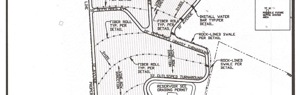
9 Example Vineyard Layout 3

10 Example Vineyard Layout Near Stream 4

11 CHAPTER TWO Roads Fine sediments eroding from roads are a major source of sediment to streams in Sonoma County and throughout Northern California. Whether it is surface runoff or concentrated storm runoff, sediment and other pollutants are reaching streams and harming our natural resources. Good planning, proper location and the use of progressive construction practices result in low maintenance, low impact roads. Removing existing access roads from within the riparian zone will reduce fine sediment inputs, greatly improving spawning and rearing habitats for salmonids and eliminate the influence of the road on the stream system. Environmental Concerns Fine sediment delivered from roads to streams reduces the flow of oxygenated water to embryos, limits invertebrate prey, fills in pools used for rearing, and cements spawning gravels, reducing the area available for adult salmonids to successfully spawn. If roads are built too close to a stream, the result is often that streams are armored and straightened to protect the adjacent road. Simplified channels provide less cover and rearing habitat for salmonids. Furthermore, roads interrupt the functions of riparian zones in providing bank stability, filtering sediment and pollutants, and providing shade, large woody debris, and invertebrates to streams. Improperly sized or designed culverts are a common barrier to fish passage in Northern California stream systems. Site Evaluation Use a map or aerial photo to view the location of the road system, including abandoned and unused roads and identify all potential sources of sediment to the stream. Identify stream crossings and the type and size of culverts. Examine the downstream side of stream crossings to see if there is erosion from concentrating flows or by directing flows into the streambank. 5
12 Best Management Practices for Agricultural Roads 1. Decommission or relocate existing roads away from the riparian zone whenever possible. 2. Weatherproof or harden daily traffic roads. Pave or chip seal before the rainy season to allow toxic compounds in the oils to solidify, degrade or volatilize from the road surface and not be delivered to waterways. 3. Establish a thick cover crop on temporary or seasonal ranch roads by October 15. Depending on traffic, this may require active seeding annually. 4. Use straw mulch during the rainy season in places where cover crops are sparse. Monitor and augment straw treatments as necessary. 5. Blade existing roads in dry weather when possible, but while moisture is still present in soil and aggregate to minimize dust and maximize compaction to prevent road fines from being discharged from the road surface. 6. Do not sidecast the bladed material to areas where the material can enter the stream directly or indirectly as sediment. Sidecast material can indirectly enter the stream when placed in a position where rain or road runoff can later deliver it to a channel that connects with the stream. 7. Out-slope roads wherever possible to prevent the concentration of flow within the ditch, to promote even draining of the road surface and to minimize disruption of the natural sheet flow pattern off the hill slope to the stream. 8. If unable to eliminate in-board ditches, crowning the road can remove half the road surface drainage from the ditch. 9. Use water bars and rolling dips to break-up slope length, diverting water to well-vegetated areas. 10. Maintain in-board ditches and line them, if needed, with geotextile fabric or rock. 11. Remove stream crossings wherever possible. 12. Replace culverts, fords, or Humboldt crossings with single span bridges where possible 13. Ensure that all stream crossings meet National Marine Fisheries Service and California Department of Fish & Game guidelines for fish passage. 14. Design culverts to pass 100-year flow. 15. Check culverts periodically during the rainy season to ensure that they are not plugged with debris. 16. Minimize erosion downstream of culverts by using energy dissipaters. 17. Monitor energy dissipaters to make sure that they do not wash away or shift. 6
13 18. Maintain culverts at the level and gradient of the stream bed. In non-fish bearing streams, with shotgun culverts, use pipe extenders (e.g., elephant trunks) to bring the discharge down to the level and gradient of the stream. Example Outsloped Road Example Insloped Road 7

14 CHAPTER THREE Cover Crops, Tillage Practices and Erosion Control Planting cover crops is the most cost effective method to reduce the introduction of sediment, nutrients, and pesticides to the stream channel through overland flow. In addition to their ability to prevent sheet erosion, cover crops can serve many agronomic purposes such as improving tilth, fixing nitrogen in the soil, and providing habitat for beneficial insects. Environmental Concerns Surface runoff can carry sediment, nutrients, and pesticides directly to a stream, where they affect salmonids and their habitat. Site Evaluation Inventory all areas that have rilling and eroded channels. Also, note areas that have sparse natural vegetation or areas where the cover crop has not taken. These areas may need some soil amendments or may need to be reseeded with a different seed mix Best Management Practices 1. Establish thick cover crops by October 15 and maintain them throughout the rainy season (until April 15). 2. Use straw mulch (2 tons/acre) in areas where cover crops are planted late in the fall or if rain is likely after the cover crop has been tilled and there is no perimeter erosion control. 3. Whenever possible, avoid tilling early in the spring or late in the fall. Leave filter strip areas or other perimeter erosion control in place if the vineyard rows are tilled early. 4. Minimize tillage practices, especially if slopes are greater than nominal (>5-10%) or if soils are highly erodible. 5. Filter strip areas or other perimeter erosion control should be left in place if the vineyard/orchard rows are tilled early. 6. Do not till turn-around areas except for the infrequent need to reduce compaction. In this case, promptly cover the soil with straw and replant with a cover crop before the rainy season. 8
15 7. If you till regularly, use sedimentation basins or vegetated filter strips to filter sediment before it reaches the stream. 8. Avoid bringing equipment into the vineyard/orchard during the wet season. Close seasonal roads to traffic and maintain permanent roads to prevent erosion. 9. Keep on site extra erosion control materials such as straw bales or wattles, gravel or geotextile fabric and train vineyard crews in their proper installation. 10.Check the site after each rainfall event. 9

16 Cover Crops Protecting bare soil surfaces is one of the best ways to prevent soil loss. Grasses, depending on the type, provide short-term soil stabilization for disturbed areas during construction of your project and can serve as long-term permanent soil stabilization for disturbed areas. There are many different seed mixtures you can choose from. Here are some key things to consider when choosing and planting a cover crop: Most important, be sure that your seed mixture provides overstory (tall fast growing plants like rye, grass, or barley) and understory (low growing broadleaf plants like clover) protection. For example, a mixture of oats and barley will only provide overstory protection and will only be slightly more effective than if you did nothing. The raindrops can still fall down between the tall plant stalks and dislodge soil particles. If you mix in some clover and brando brome, you will get understory protection and the soil will have better protection. The amount of seed you will need depends on the mix you choose. It can range from 30 lbs per acre for a more permanent type of cover crop to 90 lbs per acre for a quick erosion control soil builder mix. Your seed company will be able to help you determine what mix is best for your project and give you the recommended seed rate. Broadcast your seed in the fall. In order to have adequate protection by the start of the rainy season (October 15), the seed should be planted by mid-september. Initial irrigation will be required for most grasses with follow-up irrigation and fertilization. The cover crop should look like a lawn by October 15 (for new plantings and November 15 for replants) in order to provide adequate protection for the soil during the first heavy rains. If you cannot plant by mid-september and irrigate the seed, then you may plant your seed in October and cover it with straw mulch applied at the rate of two tons per acre. 10

17 The following section will give you guidelines on seed mixes for cover crops and application rates. Example Cover Crop Seed Mix 11

18 Example Cover Crop Seed Mix Straw Mulch Straw Mulch 12

19 Straw Mulch The most effective erosion control practice (both in terms of protection and cost) is the use of cover crop and straw mulch. Straw provides a cushion between the disturbed soil and the velocity of the raindrop. It s the best insurance for protection from the early rains if you cannot plant your cover crop in mid-september and irrigate it. In order for straw to be effective, you must apply it at the rate of two tons per acre (about 42 bales per acre). You should not be able to see any soil once the straw is applied. Rice straw is the cleanest straw in terms of other weed seeds, but it is a coarse straw and therefore takes longer to degrade. Any straw or grass hay will work provided it s applied at the rate of two tons per acre. If you are in an area that has high winds in the fall you must anchor your straw into the ground. You can do this by tracking it in (see example) or by crimping it. Otherwise, be prepared to replace the straw that gets blown away. Keep extra straw bales stored for emergency erosion control repairs. If you have an area that starts to gully you can stuff the gully with straw. You can also build emergency dikes to control drainage (see sediment barrier example). 13

20 Example Tracking In Straw Mulch Notes: 1. Roughen slope with bulldozer. 2. Broadcast seed and fertilizer. 3. Spread straw mulch 3 thick (2 tons/acre). 4. Punch straw mulch into slope by running bulldozer up and down the slope. 5. Tracking with machinery on sandy soil provides roughening without undue compaction. Example Straw Bale Sediment Barrier 14

21 Straw Wattles Straw wattles or fiber rolls are designed to slow down runoff, filter and trap sediment before the runoff gets into watercourses. Straw wattles are porous and allow water to filter through fibers and trap sediment. They also slow down runoff thereby reducing sheet and rill erosion. Straw wattles are effective on slopes to shorten the slope length. They are designed for short slopes or slopes flatter than 3:1 and low surface flows not to exceed 1 c.f.s. for small areas. Straw wattles can also be used along stream banks for extra protection. They come in several sizes ranging from 8 to 20 inches in diameter. It s very important that straw wattles are installed properly. If they re not installed properly, they will not work. Straw wattles must be installed on contour. You may need to have a surveyor help you to be sure you find the contours of your area. A good rule of thumb for vertical spacing is: 3:1 slopes = 30 feet apart, 4:1 slopes = 40 feet apart, or as the project engineer dictates. Cover Crop should be seeded prior to installation. You will then need to dig a concave key trench 2 to 4 inches deep along the contour. Place the roll in the trench and stake (see example). You must backfill the trench on the uphill or flow side of the roll to prevent water from undercutting the roll. When more than one fiber roll is placed in a row, the roll should be abutted securely to one another with stakes to provide a tight joint. Do not overlap the joint. After your fiber rolls are in place, the straw mulch can be applied at the rate of 2 tons per acre. Do not drive over the straw wattles. 15
22 Example Straw Wattle 16
23 CHAPTER FOUR Drainage Drainage systems should be designed and maintained to maximize infiltration and minimize sediment delivery to stream by dissipating flow energy, spreading flow, and encouraging infiltration. Drainage systems need to be periodically monitored and maintained to address erosion issues before they cause severe erosion or require costly repairs. It is better to have numerous discharge points in order to avoid the scouring effects of concentrated flow. Drainage systems can, and in some cases should, be designed to discharge into an off-channel water supply reservoir rather than directly to streams. Drainage systems in new vineyards/orchards or replants in Sonoma County are required by county ordinance to be designed for at least a 25-year storm. They can require design or design approval by an approved civil engineer and should incorporate natural features of the landscape (such as swales) into the drainage system. Environmental Concerns Excess fine sediment suffocates developing salmonid embryos, reduces the availability of invertebrate prey to juvenile salmonids, reduces the depth of pools used for rearing, and embeds spawning gravels. Drainage systems should be designed to allow for infiltration and filtration of fine sediment to maintain quality instream habitat conditions for salmon and steelhead. Drainage systems that rapidly transport rainfall to a stream increase peak flows and decrease groundwater recharge. Changing the natural hydrograph can act as a barrier for fish migrating upstream as adults or downstream as smolts. Site Evaluation Inventory all streams, natural drainage swales, wetlands and ponds, existing drainage structures such as culverts under roads, drainage ditches, inlets, outfalls, and sediment ponds. Evaluate any existing erosion problems and unstable areas. 17
24 Best Management Practices 1. In accordance with the Sonoma County Grading Drainage and Vineyard and Orchard Site Development Ordinance, design drainage system to handle a 25-year storm; obtain designs or design approval from a civil engineer as required. 2. Incorporate natural drainage features into the vineyard/orchard plan to maintain natural sheet flow whenever possible. Consider using vegetated swales as an option to drain pipe whenever possible. 3. Monitor vegetated swales for signs of instability, especially in vineyards/orchards with more than minimal slopes and where water has been concentrated into the swale. Consider reinforcing swales with geotextile fabric or grade control structures for additional stability. 4. Spread and slow flows by incorporating the following BMP options into the drainage system: Vegetated filter strips Rocked energy dissipaters Vegetated check dams or straw bale sediment barriers along ditches or swales Daylight underground outlets to rocked ditches or vegetated swales Sediment or infiltration basins Straw wattles 5. Increase rainfall infiltration to recharge aquifers using the following BMP options: Cover crops Straw mulching Detention ponds Infiltration galleries. 6. Use equipment or specialty tires that minimize soil compaction. 7. Provide sediment collection features on all drop inlets. 8. Provide energy dissipaters for all pipe outfall areas. 9. Discharge drainage pipes upslope of riparian areas and stream banks. 10. Use trash racks or caps on drop inlets to prevent debris such as branches from entering the system. 11. Maintain capacity of sediment basins by removing sediments when dry and placing sediment in an area where it will not enter a stream. Design the release of water from sediment basins to mimic natural flow patterns while retaining the sediment in the pond. 12. Perform culvert and drop inlet cleaning on a regular basis, before the wet season begins (October 15) as well as during and after any large storm. 13. Check temporary erosion control measures and repair as needed during and after storms: Remove sediment as needed from silt fences, sandbags, straw wattles, and sediment traps. Permanent measures, such as seeding, planting, and rocking, are preferred once the source of any runoff problem is corrected. 18
25 Example of Vineyard Inlet With Sediment Trap All drop inlets should have a sediment collection component. Surface water should be filtered in some way to allow the fines to settle out before the water enters the pipe. Existing drop inlets that do not have a sediment collection component can be easily modified by adding a corrugated plastic pipe collar around the existing pipe. The collection area (sump) must be a minimum of 6 inches deep. Example of Concrete Inlet With Sediment Trap 19
26 Example of Rock Outlet for Storm Drains All pipe outfalls should have scour protection to minimize sediment delivery downstream. The size of the dissipater is dependent on the size of the pipe. Rock protection can be easily added to existing pipe outfalls. Do not outfall the pipe directly into a creek. 20
27 Example of Rock Outlet for Swales All swale outfalls should have scour protection to minimize sediment delivery downstream. Rock protection can be easily added to existing swales. 21
28 Example Sediment Basin Basins should be designed to drain within 72 hours following storms. The length of the basin should be more than twice the width of the basin determined by measuring the distance between the inlet and the outlet. All slopes should be protected with erosion control blankets. 22
29 Example Ag Road Water Bar Water bars should be installed when the slope of the road or avenue exceeds 15%. Construct water bars not more than 100 feet apart or 50 feet apart for steeper slopes. 23
30 Example Temporary Drainage Swale 24

31 CHAPTER FIVE Riparian Zones Riparian zones provide and maintain many of the essential habitat features necessary to complete the salmonid life cycle such as erosion control, shade and temperature regulation, macroinvertebrate food supply, large woody debris supply, and filtration of sediments, nutrients, and pollutants. Riparian vegetation also increases the water storage capacity of the soil, allowing for increased flow volumes within the streams during the warmer months. Environmental Concerns Bare stream banks are significantly more likely to erode than forested stream banks. Excessive bank erosion degrades salmonid habitat by filling pools, burying spawning gravels, and decreasing macroinvertebrate production. Removal of riparian vegetation causes elevated stream temperatures which can create thermal migration barriers for migrating salmon, generate stressful rearing conditions, decrease oxygen solubility and encourage disease. Loss of large woody debris alters natural geomorphic functions. Loss of litterfall alters the food source for many aquatic macroinvertebrates which in turn are important salmonid food source. Site Evaluation Evaluate your riparian areas. Measure the smallest and largest portions of the existing riparian zone, as well as vegetation composition, the extent of stream shading, and the distance from the edge of the riparian corridor to the first row of vines/orchard. Note any previous land use practices, infrastructure, roads, or structure within the riparian zone. 25
32 Best Management Practices 1. Abide by the required stream, pond, and wetland setbacks as defined in the County s Grading, Drainage, Vineyard/Orchard Site Development Ordinance. 2. Maintain the existing riparian zone. A healthy riparian zone consists of trees, shrubs of different ages growing closest to the channel and a grassy zone closest to the vineyard/orchard operation. 3. Maintain existing riparian vegetation to provide at least 65% shading of streams less than 50 feet in wetted width. 4. Plant native species in riparian zones that are not presently forested. Irrigate for the first two or three years and protect from browsing. Once established, leave riparian zone in a natural state. 5. Replace existing all-weather access roads that are within the county required setback no touch areas with grassy avenues. If the road must be used as an all-weather access road, then move the road out of the setback area and replant the old roadbed with riparian vegetation and/or a filter strip. 6. Leave downed trees in the riparian corridor for recruitment as large woody debris, as long as it does not pose an immediate threat to infrastructure or property downstream. 7. Maintain grass buffers along natural streams and drainage channels with a defined bed and bank. 8. Cooperate in watershed-wide restoration projects that will help to improve riparian habitat. 26
33 Required Stream Setbacks (Sonoma County Grading, Drainage, Vineyard/Orchard Site Development Ordinance): DETAILS: Existing riparian corridors should be maintained. The roots of the vegetation provide bank stability. Shade from trees and bushes keep water temperatures cool, which is important for sustaining aquatic species. Native grasses help filter sediment from surface runoff. However, if the existing vegetative cover is in poor condition the setback area may be improved with a vegetative filter strip for use as an agricultural avenue. The strip must be planted with a filter strip seed mix and maintained for the intended use. Level I Projects and All Replants (Setbacks apply to all new vineyards/orchards with a slope of 10% or less on highly erodible soils or 15% or less on non-highly erodible soils and all replant projects, unless stricter requirements are established in the general plan, local coastal program, and/or zoning code.) NOTE: Vegetative filter strips may be used as turnarounds or grassy avenues provided the filter strip is maintained for the intended use. 27
34 Level II Projects (Setbacks apply to all new vineyards/orchards with a slope greater than 10% on highly erodible soils and greater than 15% on non-highly erodible soils, unless stricter requirements are established in the general plan, local coastal plan, and/or zoning code.) All Designated Streams Undesignated streams require a 25 ft. (min.) setback NOTE: Vegetative filter strips may be used as turnarounds or grassy avenues provided the filter strip is maintained for the intended use. 28
35 Example Vineyard Setback/Filter Strip Required Wetland and Pond Setbacks (Sonoma County Grading, Drainage, Vineyard/Orchard Site Development Ordinance) DETAILS: Existing wetland and pond vegetation should be maintained. The roots of the vegetation provide bank stability. Shade from trees and bushes keep water temperatures cool, which is important for sustaining aquatic species. Native grasses help filter sediment from surface runoff. However, if the existing vegetative cover is in poor condition, the setback area may be improved with a vegetative filter strip for use as an agricultural road. The strip must be planted with a filter strip seed mix and maintained for the intended use. (Setbacks apply to all new vineyards/orchards, unless stricter requirements are established in the general plan, local coastal plan, and/or zoning plan.) NOTE: Vegetative filter strips may be used as turnarounds or grassy avenues provided the filter strip is maintained for the intended use. 29

36 Sonoma County Agricultural Commissioner s Office 133 Aviation Blvd., Ste. 110 Santa Rosa, CA Phone: (707) Fax: (707)
Urban Conservation Practice Physical Effects ESTABLISHMENT, GROWTH, AND HARVEST NUTRIENT MANAGEMENT
 NOT WELL 800 - Urban Stormwater Wetlands A constructed system of shallow pools that create growing conditions for wetland plants to lessen the impacts of stormwater quality and quantity in urban areas.
Town of Essex Small Site Erosion Control Guide
 Town of Essex Small Site Erosion Control Guide Why do we need to protect against erosion? Water Quality: Erosion and the transport of sediment and pollutants impacts the water quality of nearby streams
Chapter Six: Tree Removal and Erosion Control
 Chapter Six: Tree Removal and Erosion Control Through the combination of canopy and roots, trees help protect and stabilize the land. Their removal requires proper planning and adherence to land-based
SECTION 6. Routine Maintenance Activity Details
 SECTION 6 Routine Maintenance Activity Details 80. DEBRIS REMOVAL When Deadfall, and other objects, such as shopping carts, tires, appliances, and mattresses have accumulated in the drain. Why To prevent
City of Stoughton Erosion Control Permit Application (effective 2/6/2018)
") City of Stoughton Erosion Control Permit Application (effective 2/6/2018) Incomplete applications will not be accepted Project Name: Address of subject property: Landowner Name(s): Applicant Name: Landowner
City of Stoughton Erosion Control Permit Application (effective 2/6/2018) Incomplete applications will not be accepted Project Name: Address of subject property: Landowner Name(s): Applicant Name: Landowner
MANUAL OF DESIGN, INSTALLATION, AND MAINTENANCE REQUIREMENTS FOR STORMWATER MANAGEMENT PLANS
 MANUAL OF DESIGN, INSTALLATION, AND MAINTENANCE REQUIREMENTS FOR STORMWATER MANAGEMENT PLANS May 2007 SECTION 1 Responsibility of Applicant TABLE OF CONTENTS A. Stormwater Management Plan Required Information
PERMANENT SEEDING. Overview of Sedimentation and Erosion Control Practices. Practice no. 6.11
 Overview of Sedimentation and Erosion Control Practices Practice no. 6.11 PERMANENT SEEDING Permanent vegetation controls erosion by physically protecting a bare soil surface from raindrop impact, flowing
Part IV(a): BMPs for Erosion, Sediment, Velocity Control
: BMPs for Erosion, Sediment, Velocity Control") Part IV(a): BMPs for Erosion, Sediment, Velocity Control Find Design Standards and Specifications for Iowa Erosion and Sediment Control Practices at: www.iowasudas.org Erosion Control Keeping the soil
Part IV(a): BMPs for Erosion, Sediment, Velocity Control Find Design Standards and Specifications for Iowa Erosion and Sediment Control Practices at: www.iowasudas.org Erosion Control Keeping the soil
POST-FIRE RESTORATION Dos and Don ts
 POST-FIRE RESTORATION Dos and Don ts USDA Natural Resources Conservation Service The NRCS/RCD office is located at: 744 LA GUARDIA ST BLDG A SALINAS, CA 93905-3354 (831) 424-1036 (NRCS) (831) 424-1036
EROSION & SEDIMENT CONTROL
 EROSION & SEDIMENT CONTROL Surface Water Protection During Well Site Construction Kelly Kees, PE WVDEP, Office of Oil and Gas SEDIMENT & EROSION CONTROL PLANS Per West Virginia State Code 22-6-6(d) 22-6A-7(c),
Structural Storm Water Best Management Practices (BMPs)
") Structural Storm Water Best Management Practices (BMPs) Storm Water Permitting: The SWPPP Revealed By Deron Austin, PE January 11, 2006 3:30-5:00 PM Orlando, Florida Presentation Outline Preface About
Structural Storm Water Best Management Practices (BMPs) Storm Water Permitting: The SWPPP Revealed By Deron Austin, PE January 11, 2006 3:30-5:00 PM Orlando, Florida Presentation Outline Preface About
Erosion Control for Home Builders in the. City of Jacksonville
 Erosion Control for Home Builders in the City of Jacksonville Eroding construction sites are a leading cause of water quality problems in Jacksonville. For every acre under construction, about a dump truck
Homeowners Guide to Stormwater BMP Maintenance
 Homeowners Guide to Stormwater BMP Maintenance What You Need to Know to Take Care of Your Property Rain Barrel Dry Well Rain Garden Pervious Asphalt Porous Pavers City of El Monte Stormwater BMP Management
General Information. Site Conditions. 9b 9b. 9a 1b. Best Management Practices Illustration
 Model Construction SWPPP Planning & Development Services 1800 Continental Place Mount Vernon WA 98273 voice 360-416-1320 inspections 360-416-1330 www.skagitcounty.net/stormwaterpermitting Permit #: General
Alternative Names: Erosion Control Matting, Erosion Control Netting, Rolled Erosion Control Products (RECP)
") 4.5-s EROSION CONTROL BLANKET SYSTEM Alternative Names: Erosion Control Matting, Erosion Control Netting, Rolled Erosion Control Products (RECP) DESCRIPTION Erosion control blanket systems are woven or
4.5-s EROSION CONTROL BLANKET SYSTEM Alternative Names: Erosion Control Matting, Erosion Control Netting, Rolled Erosion Control Products (RECP) DESCRIPTION Erosion control blanket systems are woven or
Shelbyville, KY Stormwater Best Management Practices. Section 2 EROSION PREVENTION AND SEDIMENT CONTROL PLAN
 Section 2 EROSION PREVENTION AND SEDIMENT CONTROL PLAN 2.1 Requirements The City of Shelbyville, KY will require an Erosion Prevention and Sediment Control (EPSC) Plan for most types of development construction.
5. LOW IMPACT DEVELOPMENT DESIGN STANDARDS
 5. LOW IMPACT DEVELOPMENT DESIGN STANDARDS Low Impact Development (LID) requires a shift in stormwater management away from conveying runoff to a small number of downstream points through hydraulically
Vegetated Filter Strips and Buffers
 3.15 Sediment Control Description: Buffer strips (existing vegetation) and filter strips (planted vegetation) are sections of vegetated land adjacent to disturbed areas. They are designed with low slopes
STREAM ALTERATION PRACTICES
 STREAM ALTERATION PRACTICES Stream Diversion Channel SDC DEFINITION A temporary channel constructed to convey stream flow around in-stream construction. PURPOSE Stream diversion channels are used to allow
Chapter 11 Site Rehabilitation and Stabilization
 Chapter 11 Site Rehabilitation and Stabilization Chapter 11 Layout: Part 1 - Page 131 Planning Site Rehab Part 2 - Page 132 Controlling Runoff and Capturing Sediment Part 3 - Page 133 Rehab for Crossings
Why Control and Prevent Erosion?
 Mark Risse, Rills are often obvious on steep or unprotected banks. Development of soil crust reduces infiltration, causing more runoff and erosion. This rill could easily turn into a gully if erosion is
VEGETATED SLOPE STABILIZATION DESCRIPTION APPLICABILITY. Advantages
 4.2-d VEGETATED SLOPE STABILIZATION Alternative Names: Willow Wattles, Live Bundles, Fascines, Live Staking, Joint Planting, Branch Packing, Brush Layering, and Brush Matting DESCRIPTION Vegetated slope
Vegetated Filter Strips and Buffers
 3.15 Sediment Control Description: Buffer strips (existing vegetation) and filter strips (planted vegetation) are sections of vegetated land adjacent to disturbed areas. They are designed with low slopes
Buffer Zone (BZ) Stream Protection. The width and plant composition of a buffer zone will determine its effectiveness.
 Stream Protection. The width and plant composition of a buffer zone will determine its effectiveness.") Buffer Zone (BZ) Figure BZ-1 Buffer Zone in Agricultural Area Practice Description A buffer zone is a strip of plants adjacent to land-disturbing sites or bordering streams, lakes, and wetlands that provides
Buffer Zone (BZ) Figure BZ-1 Buffer Zone in Agricultural Area Practice Description A buffer zone is a strip of plants adjacent to land-disturbing sites or bordering streams, lakes, and wetlands that provides
SUPPORTING DOCUMENT STORMWATER POLLUTION PREVENTION PLAN (SWPPP) NARRATIVE
 NARRATIVE") SUPPORTING DOCUMENT STORMWATER POLLUTION PREVENTION PLAN (SWPPP) NARRATIVE Please complete this narrative form and submit with your SWPPP drawings. Refer to Kitsap County Stormwater Design Manual Vol.
SUPPORTING DOCUMENT STORMWATER POLLUTION PREVENTION PLAN (SWPPP) NARRATIVE Please complete this narrative form and submit with your SWPPP drawings. Refer to Kitsap County Stormwater Design Manual Vol.
Wisconsin Contractors Institute Continuing Education
 Wisconsin Contractors Institute Continuing Education Erosion & Sediment Control Course # 12775 2 hours Wisconsin Contractors Institute N27 W23953 Paul Road, Suite 203 Pewaukee, WI 53072 Website: www.wicontractorsinstitute.com
12/7/2007. Christopher B. Burke Engineering West, Ltd Aux Sable Creek Watershed Plan Update 1
 The ABC s of BMP s Aux Sable Watershed Plan St. Charles, IL Why are BMP s Important Best Management Practices (BMPs) developed as a set of practices which help to achieve goals of the Clean Water Act and
CHAPTER 4. SPECIAL CONDITION EROSION CONTROL MEASURES
 CHAPTER 4. SPECIAL CONDITION EROSION CONTROL MEASURES 4.1 INFILTRATION BASIN AND TRENCH Figure 4.1. Infiltration basin and trench (Source: Department of Civil, Construction, and Environmental Engineering,
Illinois Urban Manual
 Illinois Urban Manual Jim Nelson: Association of Illinois Soil and Water Conservation Districts (AISWCD) Funding for this project provided, in part, by the Grand Victoria Foundation of Elgin IL, the Governor
Use of Best Management Practices
 Use of Best Management Practices Presented at the ANJEC Flood Hazard Workshop Bordentown, NJ March 13, 2008 Stormwater BMPs "a technique, measure or structural control that is used for a given set of conditions
Protect Stormwater Quality Project and Site Management Training for General Contractors. Presenter Becky Pearson Professional Civil Engineer
 Protect Stormwater Quality Project and Site Management Training for General Contractors Presenter Becky Pearson Professional Civil Engineer Part II Best Management Practices (BMPs) What is a Best Management
Nevada Contractors Field Guide for Construction Site Best Management Practices (BMPs)
") June 2008 Nevada Contractors Field Guide for Construction Site Best Management Practices (BMPs) Funding for the development and production of the Nevada BMP Field Guide was provided by the Nevada Division
June 2008 Nevada Contractors Field Guide for Construction Site Best Management Practices (BMPs) Funding for the development and production of the Nevada BMP Field Guide was provided by the Nevada Division
Using the Updated RI Soil Erosion and Sediment Control Handbook. The Introductory Workshop for RIDEM/CRMC Staff January 23, 2015
 Using the Updated RI Soil Erosion and Sediment Control Handbook The Introductory Workshop for RIDEM/CRMC Staff January 23, 2015 URI Cooperative Extension NEMO URI Cooperative Extension NEMO White Oak,
EROSION & SEDIMENT CONTROL
 EROSION & SEDIMENT CONTROL 1 EROSION & SEDIMENT CONTROL Effective Soil & Water Protection Whether you want to prevent soil erosion caused by rain, water and wind, or protect waterways from inevitable build
WQ-23 MOUNTAINOUS AND STEEP SLOPE SITES
 Greenville County Technical Specification for: WQ-23 MOUNTAINOUS AND STEEP SLOPE SITES 1.0 Mountainous and Steep Slope Sites 1.1 Description The geographic locations of portions of Greenville County are
SOIL EROSION AND SEDIMENT CONTROL
 SOIL EROSION AND SEDIMENT CONTROL SECTION 1: AUTHORITY, TITLE AND PURPOSE 11. STATUTORY AUTHORIZATION This ordinance is adopted pursuant to the provisions of the Federal Water Pollution Control Act 86
STORMWATER MANAGEMENT CODES ANALYSIS RICHLAND COUNTY, SC SITE PLANNING ROUNDTABLE
 STORMWATER MANAGEMENT CODES ANALYSIS RICHLAND COUNTY, SC SITE PLANNING ROUNDTABLE Codes analyses for each subcommittee were completed to assist participants of the Richland County Site Planning Roundtable.
HYDRAULIC DESIGN involves several basic
 Chapter 6 Tools for Hydr draulic and Road Design HYDRAULIC DESIGN involves several basic concepts that must be considered to build successful projects with a minimum risk of failure (Photo 6.1). Use of
Worksheet #14 Water Runoff Management
 Water Runoff Management Use this worksheet to assess how well your property minimizes the potential for water runoff and property damage.. Why should you be concerned? What can you do? Rural runoff, also
Construction Management & Engineering Division. Understanding Swales
 Construction Management & Engineering Division Understanding Swales The Florida hydrological cycle it all starts and ends here. Rainfall becomes stormwater when it can no longer soak into the ground and
2001 Southeastern Pennsylvania Stormwater Management Symposium Villanova University. Jean K. Akers
 2001 Southeastern Pennsylvania Stormwater Management Symposium Villanova University Abstract Planting For Water Quality Incorporating plantings into stormwater BMP design to improve water quality. Jean
BIORETENTION FACILITY
 ILLINOIS URBAN MANUAL PRACTICE STANDARD BIORETENTION FACILITY (feet) CODE 800 Source: Jessica Cocroft, Winnebago Soil and Water Conservation District DEFINITION Facility that utilizes a soil media, mulch,
CITY OF TUMWATER 555 ISRAEL RD. SW, TUMWATER, WA (360) (360) (FAX)
 (360) (FAX)") CITY OF TUMWATER 555 ISRAEL RD. SW, TUMWATER, WA 98501 (360) 754-4180 (360) 754-4126 (FAX) Email: cdd@ci.tumwater.wa.us APPENDIX II-C SHORT FORM CONSTRUCTION STORMWATER POLLUTION PREVENTION PLAN (SWPPP)
CITY OF TUMWATER 555 ISRAEL RD. SW, TUMWATER, WA 98501 (360) 754-4180 (360) 754-4126 (FAX) Email: cdd@ci.tumwater.wa.us APPENDIX II-C SHORT FORM CONSTRUCTION STORMWATER POLLUTION PREVENTION PLAN (SWPPP)
The Low Risk Site Handbook
 The Low Risk Site Handbook for Erosion Prevention and Sediment Control The content of this Handbook is adapted from the New York State Standards and Specifications for Erosion and Sediment Control-August
Understanding Drainage Options What s Feasible and Legal. February 2019
 Understanding Drainage Options What s Feasible and Legal February 2019 Outline for the Presentation Do you need a permit? Does common law apply? Does local government approve it? Will my neighbor allow
Post Construction BMPs
 Post Construction BMPs Why are Post Construction BMPs important? With increased development brings the increase of impervious cover Parking lots, rooftops, driveways Storm water runoff volume increases
STANDARD SPECIFICATIONS SECTION TEMPORARY EROSION AND SEDIMENT CONTROL
 STANDARD SPECIFICATIONS SECTION 01570 TEMPORARY EROSION AND SEDIMENT CONTROL PART 1 GENERAL 1.1 DESCRIPTION A. Section includes requirements, procedures, and methods related to responsibilities for providing
Maintaining Your Neighborhood Stormwater Facilities
 Maintaining Your Neighborhood Stormwater Facilities How to identify stormwater facilities and keep them working Layout by the Thurston County Storm and Surface Water Utility with thanks to the Delaware
Storm Water Basics for Construction Sites Presented by Representatives from the City of Grass Valley and Nevada County
 September 22nd, 2015 3:30PM Sign up at: www.stormwaterawareness.org Workshop is free! Nevada County Contractor s Association 149 Crown Point Ct. Grass Valley, CA 95945 Storm Water Basics for Construction
RAIN GARDEN ILLINOIS URBAN MANUAL PRACTICE STANDARD. (feet) CODE 897 DEFINITION
 CODE 897 DEFINITION") ILLINOIS URBAN MANUAL PRACTICE STANDARD RAIN GARDEN (feet) CODE 897 Source: Kendall County Soil and Water Conservation District DEFINITION Rain gardens are small, shallow, flat bottomed depressions constructed
ILLINOIS URBAN MANUAL PRACTICE STANDARD RAIN GARDEN (feet) CODE 897 Source: Kendall County Soil and Water Conservation District DEFINITION Rain gardens are small, shallow, flat bottomed depressions constructed
Information for File # JTF
 Information for File # 2013-04665-JTF Applicant Corps Contact Enbridge Energy, Limited Partnership Josh Fitzpatrick Address 1554 Highway 2, Suite 2, Two Harbors, MN 55616 E-Mail joshua.t.fitzpatrick@usace.army.mil
ENVIRONMENTAL BEST PRACTICES EROSION AND SEDIMENT CONTROL
 ENVIRONMENTAL BEST PRACTICES EROSION AND SEDIMENT CONTROL JUNE 2003 UPDATED FEBRUARY 2012 PREFACE The purpose of this document is to provide guidance to field personnel (construction contractors, maintenance
Managing Manure: The Role of Riparian Buffers
 Managing Manure: he Role of Riparian Buffers Fact Sheet Equine Facilities Manure Management Practices June 2003 Equestrians have become aware of the potential environmental impacts that may be caused by
Guiding Landowners in Stream Restoration. The Science, Practice & Art of Restoring Native Ecosystems 2015
 Guiding Landowners in Stream Restoration The Science, Practice & Art of Restoring Native Ecosystems 2015 January 24, 2015 Guiding Landowners in Stream Restoration January 24, 2015 Agenda 1Watershed Planning
SOP 6: Erosion and Sedimentation Control SOP 6: EROSION AND SEDIMENTATION CONTROL
 Standard Operating Procedures Central Massachusetts Regional Stormwater Coalition SOP 6: Erosion and Sedimentation Control SOP 6: EROSION AND SEDIMENTATION CONTROL Erosion and sedimentation from land-disturbing
Maintaining Your Neighborhood Stormwater Facilities How to identify stormwater facilities and keep them working
 Maintaining Your Neighborhood Stormwater Facilities How to identify stormwater facilities and keep them working Photo to go here Table of Contents Getting to know your Stormwater Facilities..3 Fences and
REFERENCE DRAWINGS FOR 332 W. MAIN STREET ROCK HILL, SOUTH CAROLINA
 REFERENCE DRAWINGS FOR REET ROCK HILL, SOUTH CAROLINA COVER SHEET 1 OF 6 GENERAL NOTES 2 OF 6 REMOVE WIRE AND NYLON TWINE FROM BALL AND CANOPY. SOAK ROOT BALL AND PLANT PIT IMMEDIATELY AFTER INSTALLATION.
Tips for Maintaining and Enhancing Stormwater Management Areas
 4 4 N. Second Street, Denton, Md. 21629 (410) 479-3625 (410) 479-3534 fax www.dentonmaryland.com Tips for Maintaining and Enhancing Stormwater Management Areas Information provided by the Town of Denton
4. CONCEPT PLAN DEVELOPMENT
 4. CONCEPT PLAN DEVELOPMENT Concept Plan Step 1: Identify Site Constraints and Opportunities Review the existing site to identify constraints and opportunities for GI Practices to meet the RRv. Constraints
5/15/2013. Basin Area. Vegetation. Rainfall & Runoff. Soil Type. Topics. Factors Influencing Erosion. Factors Influencing Erosion
 Topics Erosion, TESC and Construction sequencing Procedures and timing Remedies for failing sites Curtis Hinman WSU Extension and Bio Systems Eng. Faculty Low Impact Development Specialist chinman@wsu.edu
Pavement Removal Fact Sheet
 Rushern L. Baker, III County Executive Pavement Removal Fact Sheet What is pavement removal? Pavement removal is the replacement of impervious surfaces, such as asphalt and concrete, with grass or native
2.1.4 Roof Downspout Rain Gardens
 2008 SWMM, 2010 Revision City of Tacoma 2.1.4 Roof Downspout Rain Gardens Purpose and Definition Bioretention areas are shallow stormwater retention facilities designed to mimic forested systems by controlling
CHECKLIST BMPs for FIELD NURSERIES REGULATIONS, SITE SELECTION, WATER MANAGEMENT
 CHECKLIST BMPs for FIELD NURSERIES REGULATIONS, SITE SELECTION, WATER MANAGEMENT Regulations For information on the Wetlands Protection Act or the Water Management Act, contact the Massachusetts Department
Stormwater Management Techniques WMPF LAND USE TRAINING INSTITUTE MARCH 14, 2018
 Stormwater Management Techniques WMPF LAND USE TRAINING INSTITUTE MARCH 14, 2018 Potential Impacts of New Development Urban development can significantly increase stormwater runoff Water quality considerations
6.1 Bioretention Areas
 SAN MATEO COUNTYWIDE WATER POLLUTION PREVENTION PROGRAM 6.1 Bioretention Areas Figure 6-1. Bioretention Area. Source: City of Brisbane Bioretention areas 1, or rain gardens, are concave landscaped areas
CHAPTER 9 STORM DRAINAGE. Minimum Requirements for New Development and Redevelopment
 CHAPTER 9 STORM DRAINAGE 9.01 General The standards established by this chapter are intended to represent the minimum standards for the design and construction of storm drainage facilities. 9.02 Design
PLAN SUBMITTER'S CHECKLIST
 Page 1 of 8 PLAN SUBMITTER'S CHECKLIST FOR EROSION AND SEDIMENT CONTROL PLANS Please fill in all blanks and reference the plan sheets/pages where the information may be found, where appropriate, or write
The Nature of Soil Soil Conservation Sustainable Ag.
 Chapter 6 & 7 The Nature of Soil Soil Conservation Sustainable Ag. Climate Soil Forming Factors Parent material Organisms Topography Time Value of Soil Soil is under appreciated Condition of soil affects
Vegetation Management
 Vegetation Management GENERAL CONSTRUCTION PRACTICE Best practice vegetation management involves giving appropriate consideration to the following issues. Not all the issues will be relevant on every site.
STREAM BANK STABILIZATION THORPS MORTIMER RECREATION AREA Grandfather Ranger District SITE LOCATION & DRAINAGE AREA
 STREAM BANK STABILIZATION THORPS CREEK @ MORTIMER RECREATION AREA SITE LOCATION & DRAINAGE AREA SITE LOCATION Drainage Area = 1.14 sq. miles STREAM BANK STABILIZATION THORPS CREEK @ MORTIMER RECREATION
Project: Developer/Designer: Reviewer: I. Narrative: 1. Project Description: Describes the nature and purpose of the land disturbing activity.
 City of Charlottesville, Virginia Erosion and Sediment Control Plan Review Checklist 610 East Market Street, Charlottesville, VA 22902 Telephone 434-970-3182; Fax 434-970-3359 Project: Developer/Designer:
Low Gradient Velocity Control Short Term Steep Gradient [1] Channel Lining Medium-Long Term Outlet Control Soil Treatment Permanent
![Low Gradient Velocity Control Short Term Steep Gradient [1] Channel Lining Medium-Long Term Outlet Control Soil Treatment Permanent](/thumbs/77/74849271.jpg "Low Gradient Velocity Control Short Term Steep Gradient [1] Channel Lining Medium-Long Term Outlet Control Soil Treatment Permanent") Grass Linings DRAINAGE CONTROL TECHNIQUE Low Gradient Velocity Control Short Term Steep Gradient [1] Channel Lining Medium-Long Term Outlet Control Soil Treatment Permanent [1] May be used on short, steep
Grass Linings DRAINAGE CONTROL TECHNIQUE Low Gradient Velocity Control Short Term Steep Gradient [1] Channel Lining Medium-Long Term Outlet Control Soil Treatment Permanent [1] May be used on short, steep
Best Management Practices
 Best Management Practices Urban Areas Aquatic Areas Natural Areas Best Management Practices Urban Areas Green Industry Best Management Practices Fertilizer Label Nitrogen Applications Phosphorous Applications
ST. MARY S SOIL CONSERVATION DISTRICT (SMSCD) AND DPW&T CONCEPT EROSION AND SEDIMENT CONTROL AND STORMWATER MANAGEMENT GUIDELINES AND CHECKLIST
 AND DPW&T CONCEPT EROSION AND SEDIMENT CONTROL AND STORMWATER MANAGEMENT GUIDELINES AND CHECKLIST") St. Mary s Soil Conservation District 26737 Radio Station Way, Suite B Leonardtown, MD 20650 Phone: 301-475-8402 ext. 3 Fax: 301-475-8391 www.stmarysscd.com St. Mary s County Government Department of Public
St. Mary s Soil Conservation District 26737 Radio Station Way, Suite B Leonardtown, MD 20650 Phone: 301-475-8402 ext. 3 Fax: 301-475-8391 www.stmarysscd.com St. Mary s County Government Department of Public
STREAM BUFFER PROTECTION AND MANAGEMENT
 ORDINANCE NO. 753 AN ORDINANCE AMENDING THE CODE OF ORDINANCES OF THE CITY OF PLEASANT HILL, IOWA 1998, BY ESTABLISHIING CHAPTER 104, STREAM BUFFER PROTECTION AND MANAGEMENT Be it enacted by the City of
SOIL EROSION COMBATING IS ESSENTIAL IN ORDER TO CONSERVE OUR VALUABLE SOIL RESOURCES
 SOIL EROSION COMBATING IS ESSENTIAL IN ORDER TO CONSERVE OUR VALUABLE SOIL RESOURCES A. Introduction - Land is also a precious resource. Land is needed for agriculture and occupation. Land is under pressure
Rain Gardens. A Welcome Addition to Your Landscape
 Rain Gardens A Welcome Addition to Your Landscape Where Does The Rainwater Go? Naturally, forests provide a way for rainwater to percolate into the soil, filtering pollutants while trees are allowed to
Erosion & Sediment Control Plan Application Form & Checklist
 Erosion & Sediment Control Plan Application Form & Checklist GENERAL INFORMATION Application Date: Project Address: Tax Map / Parcel Number(s): PROPERTY OWNER / DEVELOPER Firm Name: Contact Person: Title:
A. Install all temporary erosion control measures (in accordance with MNDOT General Conditions 2573) prior to site disturbance.
 prior to site disturbance.") The language provided in these specifications is meant to serve as a reminder and provide a generic example of the type of language that should be provided in final construction documents. This language
The language provided in these specifications is meant to serve as a reminder and provide a generic example of the type of language that should be provided in final construction documents. This language
Just The Basics: Illicit Discharge. What does it mean to me?
 Just The Basics: Illicit Discharge What does it mean to me? What is an Illicit Discharge? An illicit discharge is the discharge of pollutants or non-storm water materials to storm water drainage systems
EROSION PREVENTION BMP SUGGESTED USES MATRIX
 EROSION PREVENTION SUGGESTED USES MATRIX Processed Based Tools Software Aids Slope Waterway Surface Concentrated Flows Large Flat Stock Pile Borrow Adjacent Property Impacts Erosion Prevention Measures
Raingardens. Conserving and Protecting Water L
 L-5482 08-08 Raingardens Justin Mechell, Extension Assistant, and Bruce Lesikar, Extension Program Leader for Biological and Agricultural Engineering,The Texas A&M University System A raingarden is an
KENT COUNTY STORMWATER MAINTENANCE DISTRICT STORMWATER BMPs MAINTENANCE TASKS AND RESPONSIBILITIES GUIDANCE DOCUMENT BIO-RETENTION FACILITIES
 BIO-RETENTION FACILITIES (for all basins / BMPs) Annually Prepare Operation and Maintenance Plan. Clearly outline how vegetation in the facility and its buffer area will be managed or harvested in the
Zoning Ordinance Article 3
 Article 3 Natural Resources Protection Section 301 Natural Resources Protection 301.1. Purpose - The following natural resources protection standards are established to protect the public health, safety
When planning stormwater management facilities, the following principles shall be applied where possible.
 2.0 Principles When planning stormwater management facilities, the following principles shall be applied where possible. 2.0.1 Drainage is a regional phenomenon that does not respect the boundaries between
County of Prince Edward. Stormwater Management Plan. Agreement in lieu of a Stormwater Management Plan
 County of Prince Edward Stormwater Management Program Date: E-Permitting Number: This stormwater management plan (Agreement) is hereby submitted by the Owner to specify the methods that will be implemented
Lesson 2: Stormwater Best Management Practices (BMPs)
") Lesson 2: Stormwater Best Management Practices (BMPs) Environmental Stewards Class Christopher C. Obropta, Ph.D., P.E. Extension Specialist in Water Resources 732-932-9800 ext. 6209 obropta@envsci.rutgers.edu
Lesson 2: Stormwater Best Management Practices (BMPs) Environmental Stewards Class Christopher C. Obropta, Ph.D., P.E. Extension Specialist in Water Resources 732-932-9800 ext. 6209 obropta@envsci.rutgers.edu
DRAFT DESIGN CRITERIA STORMWATER TREATMENT STANDARDS CITY OF OVERLAND PARK
 DRAFT DESIGN CRITERIA STORMWATER TREATMENT STANDARDS CITY OF OVERLAND PARK A. Authority As set forth in the Overland Park Municipal Code (OPMC), Chapter 16.210, the Director of Planning and Development
Department of Agriculture. Conservation Service. United States. Natural Resources REVISED 8/26/16
 GENERAL NOTES: SYMBOL LEGEND 1. All work shall comply with the constriction specifications, drawings, project-specific quality assurance plan and other contract requirements. 2. All notes on the drawings
BE WATER WISE. Managing Your Onlot Stormwater. Sept. 23, 2006 Watershed Weekend
 BE WATER WISE Managing Your Onlot Stormwater Sept. 23, 2006 Watershed Weekend 2006 1 All water resources are interrelated through the Hydrologic Cycle Sept. 23, 2006 Watershed Weekend 2006 2 What is Storm
Figure 1. Bioswale along roadside. Photo courtesy of CalTrans. Figure 2. Diagram of typical bioswale (adapted from UDFCD 1999)
") Design Manual: Biological Filtration Canal (Bioswale) Dayna Yocum, Bren School of Environmental Science and Management, University of California, Santa Barbara Figure 1. Bioswale along roadside. Photo
Design Manual: Biological Filtration Canal (Bioswale) Dayna Yocum, Bren School of Environmental Science and Management, University of California, Santa Barbara Figure 1. Bioswale along roadside. Photo
SITE PLAN REVIEW ITEMS - REFERENCE CHECKLIST
 City of Seminole 9199 113 th Street N. Seminole, FL 33772 Ph: (727) 392-1966 Fx: (727) 319-6583 SITE PLAN REVIEW ITEMS - REFERENCE CHECKLIST Note: This checklist is designed to aid designers in the review
Beyond Rain Gardens Advancing the Use of Compost for Green Infrastructure, Low Impact Development, & Stormwater Management
 Beyond Rain Gardens Advancing the Use of Compost for Green Infrastructure, Low Impact Development, & Stormwater Management VORS 2018 Stormwater Management Session 2 Stormwater Management, Green Infrastructure,
SILT FENCE MACHINE SLICED ERO-1A STEEL FENCE POST (T-POST), MINIMUM 5' LONG, 6' MAXIMUM SPACING.
, MINIMUM 5' LONG, 6' MAXIMUM SPACING.") STEEL FENCE POST (T-POST), MINIMUM 5' LONG, 6' MAXIMUM SPACING. ATTACH FABRIC TO POSTS WITH MINIMUM 3 ZIP TIES (50 LB. TENSILE) PER POST IN TOP 8" OF FABRIC. MONOFILAMENT GEOTEXTILE FABRIC PER MNDOT TABLE
STEEL FENCE POST (T-POST), MINIMUM 5' LONG, 6' MAXIMUM SPACING. ATTACH FABRIC TO POSTS WITH MINIMUM 3 ZIP TIES (50 LB. TENSILE) PER POST IN TOP 8" OF FABRIC. MONOFILAMENT GEOTEXTILE FABRIC PER MNDOT TABLE
The proper use of erosion and sediment controls will allow the following objectives to be met:
 Chapter 5 5.0 Introduction During construction activities, soil is typically moved or disturbed in a way that affects stormwater drainage. The use of Best Management Practices (BMPs) during construction
C-12. Dry Pond. Design Objective
 C-12. Dry Pond Design Objective The primary purpose of dry pond is to attenuate and delay stormwater runoff peaks. Dry ponds hold water immediately after a storm event and drain to be almost complete dry
SIMPLIFIED APPROACH TO STORMWATER MANAGEMENT FOR SMALL PROJECTS
 SIMPLIFIED APPROACH TO STORMWATER MANAGEMENT FOR SMALL PROJECTS Introduction As required by federal and state law, the Borough of Swarthmore has adopted regulations that affect stormwater runoff and surface
DEALING WITH STORM WATER MANAGEMENT
 December 2012 DEALING WITH STORM WATER MANAGEMENT This fact sheet provides information on the guiding principles of storm water management practices, explains the difference between structural and non-structural
ACTIVITY: Trees, Shrubs and Vines ES 10
 Targeted Constituents Significant Benefit Partial Benefit Low or Unknown Benefit Sediment Heavy Metals Floatable Materials Oxygen Demanding Substances Nutrients Toxic Materials Oil & Grease Bacteria &
Controlling Erosion on hillside farm roads
 Controlling Erosion on hillside farm s For technical advice on underground pipes and other erosion control practices call: Santa Cruz County Resource Conservation District/Capitola NRCS 820 Bay Avenue,