OPEN SPACE CONDITION ASSESSMENT
|
|
|
- Georgiana Arnold
- 5 years ago
- Views:
Transcription


1 OPEN SPACE CONDITION ASSESSMENT Little Stanion Farm Management Company Little Stanion, Corby Ref: Version: 5 Date: April 2016 Author: Reviewer: Address: Richard heath Ian Dudley 7-8 Melbourne House Corbygate Business Park Weldon Corby Northamptonshire NN17 5JG
2 Purpose of Document Lockhart Garratt Ltd was commissioned by Little Stanion Farm Management Company to undertake an independent condition assessment of the existing public open spaces at Little Stanion, Corby. This document presents the findings of this assessment and provides, where relevant, remedial works or ongoing management recommendations for each open space type within each area. Executive Summary Despite recent heavy rainfall Little Stanion was found to be well managed and in good order. Grass cutting had yet to be commenced across the site due to the ground conditions; this delay was considered to be a positive response to the constraints posed by the weather, as any attempt to bring machinery onto grassed areas would likely cause wheel rutting and soil compacting. Works appear to have begun to restore Badger Alley following the damage caused during pylon grounding. Young trees within the front and rear woodland bunds are performing well, and starting to bud up. Of the sample demographic none were found to have failed. Overall the site is well-maintained. A number of minor actions are required to ensure that current good standard is maintained: Once cutting is underway the public open space, in particular Long Meadow, would benefit from fertiliser application. Minor repairs to amenity grass areas that have been tracked over by vehicles. Repairs to Deer fence enclosing the rear woodland bund. Clearing litter from swales and attenuation basins following storm events. Page 2 of 23
3 Table of Contents INTRODUCTION... 5 Extent of Assessment... 5 Assessment Methodology... 5 Assessment Limitations... 5 TOP MEADOW... 6 Introduction... 6 Grassland... 6 Litter... 6 LONG MEADOW... 8 Introduction... 8 Amenity Grassland... 8 Meadow Grassland... 9 Swales... 9 Ephemeral Basins Lake Fencing Litter SHORT MEADOW Introduction Grassland Swale Litter FRONT WOODLAND BUND Introduction Woodland Hedgerow Litter REAR WOODLAND BUND Introduction Woodland Path Fencing Litter BADGER ALLEY Introduction Page 3 of 23
4 Grassland Hedgerows Litter WELCOME CENTRE GREEN Introduction Grassland Herbaceous Beds Litter Appendix 1: Open Space Areas Plan This report is for the sole use of the Client. Its reproduction or use by a third party is forbidden unless written consent is obtained from the Author. Page 4 of 23
5 1. INTRODUCTION Extent of Assessment 1.1. The following open space areas of Little Stanion are currently open to the public and were considered as part of this assessment: Top Meadow Long Meadow Short Meadow Front Wooded Bund Rear Wooded Bund Badger Alley Welcome Centre Green 1.2. The locations of these various areas are shown on Plan Ref. M at Appendix 1. Assessment Methodology 1.3. The assessment was undertaken as an on-foot survey on 23 rd March 2016, in which each area was visited and comprehensively walked. The condition of the various landscape treatments (grassland, wetland, etc) was recorded, as well as general observations such as the presence or absence of litter. Illustrative photographs were taken and are displayed throughout this report in the relevant sections. Assessment Limitations 1.4. This is a landscape management assessment report and therefore any comments made in relation to hydrology, engineering or other disciplines should be taken as general comment or observation for referral to appropriate specialists This report is an assessment of the management of the resources currently in place at Little Stanion and does not cover the creation of additional landscape treatments or open space areas. Page 5 of 23

6 2. TOP MEADOW Introduction 2.1. This area is located along the north-western boundary of Little Stanion and separates the site from the adjacent woodland It comprises amenity grassland with no other features. Grassland 2.3. The grass sward is fully established with minimal broadleaf weeds present It is currently wet underfoot, which accounts for the fact that it is yet to receive the first cut of the growing season. Some minor damage was noted, likely caused by a motorcycle tracking through the area in wet conditions. The damage is minor but should be monitored for signs that compaction is impeding growth performance. Litter 2.5. No litter or dog fouling was observed within this area. Page 6 of 23

7 Page 7 of 23

8 3. LONG MEADOW Introduction 3.1. Long Meadow accounts for the largest area of open space within the site. It bisects the site from Top Meadow in a south-easterly direction, and is centred on the primary swale and associated ephemeral basins This area comprises amenity grassland for much of its length, although the south-eastern part is meadow grassland. There is a large detention basin at the lower end of the site. Amenity Grassland 3.3. The amenity grassland areas are generally well established with very little weed growth observed; however the wet winter has encouraged the establishment of rushes within the amenity areas, in particular at the lower end of Long Meadow within the levelled playing field. Whilst the presence of a minor element of rush in the main meadow sward is acceptable, it is recommended that the rushes in the playing field area be controlled through the targeted application of herbicide using a weed wiper or similar Some vehicle tracking has occurred at the lower end of Long Meadow. At the time of surveying these tracks held standing water. This highlights the fact that any attempt to cut the amenity grass would likely cause further damage by the machinery, and therefore this activity should be delayed until ground conditions improve. Page 8 of 23

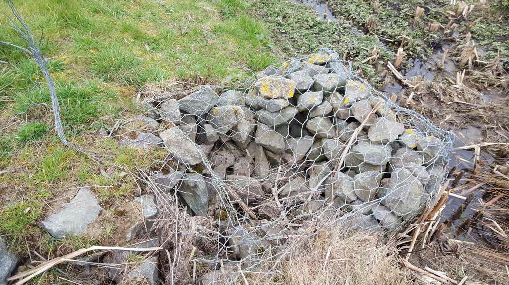
9 Meadow Grassland 3.5. The meadow grassland surrounding the lake was at the time of surveying indeterminable from the amenity grass. Once the amenity grass is cut the distinction will be more noticeable A path runs through this area which is regularly used by dog walkers. The area has suffered from vehicle tracking which has left the ground uneven in places. Swales 3.7. The swale which forms the spine of Long Meadow is well established with a range of aquatic and marginal species which are growing strongly. The channel itself has been reformed by the passage of water into a more natural appearance There are woody species (willow and dogwood) colonising the swales, particularly at the top of Long Meadow. Any goat willow should be cut and treated with herbicide to prevent further establishment One of the gabion cages, which form a vital function within the swale, has been vandalised and some of the stones removed. It is recommended that this is monitored regularly and if this behaviour persists steps should be taken Daffodils have been frequently planted on the swale margins, and were coming into flower at the time of inspection A number of shrubs have been planted around the mouths of the swale inlets. The rootstocks of these plants are established, although they were not in leaf at the time of surveying. Page 9 of 23

10 Page 10 of 23

11 Ephemeral Basins These holding basins are designed to attenuate water flow and reduce flooding in severe weather events. These basins have been thoroughly tested over the winter, and are clearly performing well at reducing flooding of the lake Over the winter months they have received management to reduce the invasive common reed Phragmites australis which would otherwise smother the areas and out-compete other wetland species. Evidence of new growth is already evident within these basins The reeds grow and spread very quickly, and it is common practice to cut them down to the rootstock every other winter. Page 11 of 23

12 Page 12 of 23

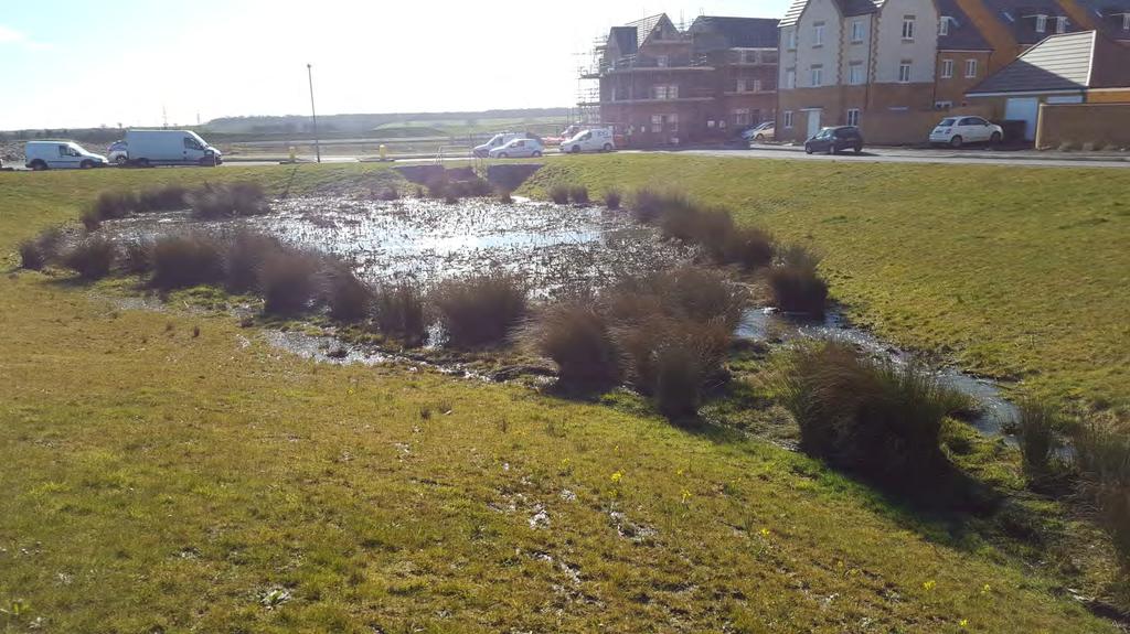
13 Lake The lake is looking well-established, with reed and rush beds and clumps of willow at the water s edge, all of which are helping to encourage overwintering birds. Minimal litter was observed It was too early in the season to accurately identify the species of willow, however it would be advisable to remove any goat willow in the first instance, as this is a far less desirable species. Not more than one third of the waterline should be allowed to be colonised by willow species, which grow very quickly and can cause problems associated with leaf drop and over-shading It is recommended that the willow colonisation is reviewed in the Autumn of 2016 to determine if coppicing should commence It is recommended that around 20% of the willows are coppiced, in small groups, every 5 years. Goat willow stumps should be treated to discourage regrowth The water appeared to be freely flowing through the overflow outfalls, however these areas do tend to get clogged with litter and debris, particularly after storm events and it is worth checking regularly Siltation should be monitored and reviewed by a suitably qualified person. Fencing A post and rail fence runs between the lake and the A43. This is generally in good order, although a small number of horizontal rails have been broken. Litter Long Meadow was generally litter-free, although a small amount had collected within attenuation basins and outlets. Page 13 of 23

14 4. SHORT MEADOW Introduction 4.1. Short Meadow is located within the south-western part of the site and runs approximately parallel to Long Meadow It mainly comprises amenity grassland, although a swale runs along its south-western boundary. Grassland 4.3. As with elsewhere on site the grass is yet to be mown for the first time this year; however it is wellestablished and relatively weed-free. Swale 4.4. The swale appears as little more than a linear depression within the grass, with gabion cages stacked at the outfall and intermittently along the length. No standing/flowing water was present at the surface. Litter 4.5. Short Meadow was litter free. Page 14 of 23

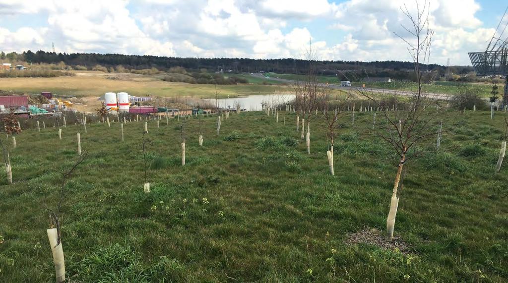
15 5. FRONT WOODLAND BUND Introduction 5.1. This feature is located between Little Stanion and Long Croft Road, and forms one of the main frontages to the site It comprises a grassed bund planted with native trees and shrubs, with a hedgerow along its northeastern boundary on the public highway frontage. Woodland 5.3. The trees and shrubs are well-established with heights between one and three metres depending upon species, and are showing good spring bud formation. Mammal protective guards and supports are in good condition, generally free of leaf debris and soil Significant deer tracks were noted in this area; it is therefore advised to leave the guards in place The grass sward is yet to receive the first annual cut due to the weather conditions, however it is wellestablished and generally free of broadleaf weeds. Hedgerow 5.6. The hedgerow plants have had their guards removed, and appear to be left alone by the deer community. The hedge has been regularly topped, and is starting to knit together to become an established hedge. Litter 5.7. There was minimal litter along the pathway, but none on the woodland bund. Page 15 of 23

16 Page 16 of 23
17 6. REAR WOODLAND BUND Introduction 6.1. This area comprises a large area of woodland along the southern boundary of the site A central path runs along the entire length of the woodland and a deer fence encloses the planted area. There are pedestrian gates in several locations along the deer fence and a vehicle gate at its eastern end A glade has been left unplanted at the southernmost point of the site and views of the surrounding landscape are obtainable from this point A large undergrounding pylon is present to the east of this area. Woodland 6.5. The trees are growing well, with good bud growth present on a random selection of plants inspected. Some recent replanting has occurred around the pylon. Mammal guards and supports are generally in good condition The grass is not competing with the trees, presumably through herbicide management, and guards were generally free of leaf litter and soil. Path 6.7. The path is well established and well-used. At the time of surveying it was clear of any trip hazards and vegetation; an area of mud was present around the break in the hedge line. Fencing 6.8. The deer fence is generally in good order, with the exception of two broken posts on the run between the woodland and the A43. The straining wire has also been cut, and should be repaired to secure the longevity of the fence. Litter 6.9. Minimal litter was observed within this area. Page 17 of 23

18 Page 18 of 23

19 Page 19 of 23

20 7. BADGER ALLEY Introduction 7.1. This area follows the line of a disused railway, which has since been restored to grassland It currently comprises disturbed ground, bordered by mature hedgerows with occasional trees. Grassland 7.3. It appears that measures have been undertaken to commence remediation of this area following excessive damage caused by vehicle tracking in sub-optimal ground conditions It is assumed that operations have been undertaken to decompact and level the worst of the damage. This has left an uneven ground surface, and as such public access to this area is to be avoided Once the land drains sufficiently the remediation program can recommence, which will see the soil regraded, the larger surface stones removed, and the re-establishment of a meadow grass sward. Hedgerows 7.6. Badger Alley is bordered to either side with mature hedgerows, which provide valuable nesting and foraging habitat for local birds Given the significant damage to the soils along Badger Alley it is advisable to monitor these hedgerows for signs of stress. Any failures should be removed and the gaps replanted. The larger branches should be cut to half-metre lengths and retained within the hedge as additional habitat. Litter 7.8. This area is generally litter free. Page 20 of 23

21 8. WELCOME CENTRE GREEN Introduction 8.1. This area surrounds the Little Stanion Welcome Centre building, at the northern extent of the site It comprises grassland with planting beds. Grassland 8.3. The grass is in good condition with no broadleaf weeds present. It has yet to be cut this year, likely due to ground conditions. Herbaceous Beds 8.4. Plants are healthy and well-established. Litter 8.5. No litter was observed within this area. Page 21 of 23

22 Page 22 of 23
23 Appendix 1: Open Space Areas Plan Ref: M Page 23 of 23

24 $ Welvome Centre Green Top meadow front Woodland Bund Long meadow Badger Alley Legend: Open space Water Short meadow Rear Woodland Bund TITLE: PROJECT/SITE: CLIENT: MAP REF: VERSION: OPEN SPACE ASSESSMENT AREAS PLAN LITTLE STANION LITTLE STANION FARM MANAGEMENT COMPANY M DATE: SCALE: 1:3,500 APPROVED BY: ID PRODUCED BY: ACB Reproduced with the permission of The Controller of Her Majesty's Stationery Office Crown Copyright (c) Licence number: AL 52281A000 Lockhart Garratt Ltd 8 Melbourne House, Corbygate Business Park, Weldon, Corby, Northants NN17 5JG. For identification purposes only. Not to be reproduced without the permission of Lockhart Garratt Ltd. 7-8 Melbourne House Corbygate Business Park Weldon, Corby Northamptonshire NN17 5JG Astley House Cromwell Business Park Chipping Norton Oxfordshire OX7 5SR
Environmental Planning & Forestry Consultants
 Environmental Planning & Forestry Consultants Contact Us: Lockhart Garratt Lockhart Garratt 7-8 Melbourne House Corbygate Business Park Weldon, Corby Northamptonshire NN17 5JG 7 Astley House Cromwell Business
HUNGERFORD SOLAR FARM
 HUNGERFORD SOLAR FARM Key Facts The site comprises approximately 26 acres/10.6 hectares of Grade 3 and 4 agricultural land, currently in arable use. It will have a generation capacity of approximately
Replacement Golf Course Facilities and Residential Development, Churston. Environmental Statement Non-Technical Summary
 Replacement Golf Course Facilities and Residential Development, Churston Environmental Statement Non-Technical Summary July 2011 Reproduced from the Ordnance Survey s map with the permission of the Controller
St Michaels C of E Junior & Infant School, Nantmel Grove, Bartley Green, Birmingham, B32 3JS
 Committee Date: 06/03/2014 Application Number: 2013/08595/PA Accepted: 19/11/2013 Application Type: Full Planning Target Date: 14/01/2014 Ward: Bartley Green St Michaels C of E Junior & Infant School,
Maintain on staggered cycle of 3 to 8 years. Try to avoid damage to the Italian Lords and Ladies
 John Steel/ 15 th Feb 2002 Printed 12/07/07 MANAGEMENT PLAN, GREENMORE PONDS AND SURROUNDING AREA DRAFT RECOMMENDATIONS Action Upper Pond: Maintain as well-vegetated pond with relatively small area (up
Public Consultation. Land at Monks Farm, North Grove. Welcome
 Welcome Welcome to our public exhibition for development on Land at Monks Farm, orth Grove. Gallagher Estates and Gleeson Strategic Land are preparing an outline planning application for new homes, open
LILAC Housing: Site Management Plan
 LILAC Housing: Site Management Plan Prepared by: Joe Atkinson. Date: 30/10/2011 Version 1.0 Relevant Legislation & Policy Conservation Regulations 1994, 2007, 2009, 2010 Wildlife & Countryside Act 1981;
NON-TECHNICAL SUMMARY
 NON-TECHNICAL SUMMARY THE HIDE, BISHOP AUCKLAND PROPOSED ECO CHALET DEVELOPMENT NON-TECHNICAL SUMMARY 1 Introduction 1.1.1 This non-technical summary for the (ES) prepared in relation to the proposed eco-chalet
Jubilee Park, Rogerstone. Management Strategy for the Maintenance of all Areas of Formal and Informal Open Space Not Adopted by the Local Authority
 Jubilee Park, Rogerstone Management Strategy for the Maintenance of all Areas of Formal and Informal Open Space Not Adopted by the Local Authority 31 October 2013 Prepared by Walters Land (Rogerstone)
Welcome to our exhibition
 Welcome to our exhibition housing development A46 Wildmoor Alcester Road Canal Quarter A422 Town Centre housing development Warwickshire-based IM Properties, one of the UK s largest privately owned property
Slough International Freight Exchange Proposals, Colnbrook+
 Welcome Welcome to this exhibition, which is being held in connection with our proposals for a new freight exchange facility on land to the north of the A4. Please take this opportunity to look at the
CLACKMANNANSHIRE COUNCIL STIRLING - ALLOA - KINCARDINE RAILWAY (ROUTE RE- OPENING) AND LINKED IMPROVEMENTS (SCOTLAND) BILL
 AND LINKED IMPROVEMENTS (SCOTLAND) BILL") CLACKMANNANSHIRE COUNCIL STIRLING - ALLOA - KINCARDINE RAILWAY (ROUTE RE- OPENING) AND LINKED IMPROVEMENTS (SCOTLAND) BILL GREAT CRESTED NEWT SURVEY REPORT JUNE 2003 Scott Wilson (Scotland) Ltd Contact:
CLACKMANNANSHIRE COUNCIL STIRLING - ALLOA - KINCARDINE RAILWAY (ROUTE RE- OPENING) AND LINKED IMPROVEMENTS (SCOTLAND) BILL GREAT CRESTED NEWT SURVEY REPORT JUNE 2003 Scott Wilson (Scotland) Ltd Contact:
LAND AT WEST YELLAND. Environmental Statement Non-Technical Summary Welbeck Strategic Land LLP
 LAND AT WEST YELLAND Environmental Statement Non-Technical Summary Welbeck Strategic Land LLP May 2014 Quality Management Issue/revision Issue 1 Revision 1 Revision 2 Revision 3 Remarks Draft FINAL Date
Homeowners Guide to Stormwater BMP Maintenance
 Homeowners Guide to Stormwater BMP Maintenance What You Need to Know to Take Care of Your Property Rain Barrel Dry Well Rain Garden Pervious Asphalt Porous Pavers City of El Monte Stormwater BMP Management
ECOLOGICAL ADVICE SERVICE
 ECOLOGICAL ADVICE SERVICE TO: FROM: Guy Wilson Marie Thibault DATE: 11 th August 2016 SUBJECT: CA/16/01502/FUL / Land adjoining Goose Farm, Canterbury Thank you for requesting advice on this application
Proposed Residential Development at Church Stile Farm in Cradley, Herefordshire. Hazel Dormouse Surveys
 Proposed Residential Development at Church Stile Farm in Cradley, Herefordshire A report to: Terra Strategic BSL Strategic Ltd. 2 The Courtyard 707 Warwick Road Solihull B91 3DA By: Udall-Martin Associates
Non-technical summary
 Non-technical summary Introduction NTS.1 is applying for outline planning permission for a residential development of up to 80 dwellings on land at Hambrook, on the northern fringe of Bristol. NTS.2 An
Tentatively Selected Plan within Harlem River, East River and Western Long Island Sound Planning Region. First Level Costs. Federal Non-Federal Total
 HARLEM RIVER, EAST RIVER AND WESTERN LONG ISLAND SOUND PLANNING REGION Flushing Bay and Creek Ecosystem Restoration Source Feasibility Study Background Study Resolution (1994), Reconnaissance Report (1996),
Creating ponds for water voles
 Creating ponds for water voles A 50-YEAR PROJECT TO CREATE A NETWORK OF CLEAN WATER PONDS FOR FRESHWATER WILDLIFE 1. Introduction Water voles have suffered a catastrophic decline in Britain over the last
SUSTAINABLE DRAINAGE AND LANDSCAPE MANAGEMENT PLAN FOR ROBINSWOOD PRIMARY SCHOOL
 SUSTAINABLE DRAINAGE AND LANDSCAPE MANAGEMENT PLAN FOR ROBINSWOOD PRIMARY SCHOOL 1.0 An introduction to sustainable drainage systems or SuDS SuDS are a new environmentally friendly approach to managing
17 NOVEMBER 2015 PLANNING COMMITTEE. on Cttee Day: 73/73. Land To The Rear Of Brook Farm Rickford Worplesdon, Bagshot Road, Woking, Surrey
 5l 14/0218 Reg d: 27.06.14 Expires:20.11.15 Ward: BR Nei. 17.07.14 BVPI Con. Target: 18 Exp: Number of Weeks On Target? on Cttee Day: 73/73 Y LOCATION: PROPOSAL: TYPE: Land To The Rear Of Brook Farm Rickford
SPG 1. * the northern and western sections which are open fields used for pasture and grazing;
 SPG 1 1.0 INTRODUCTION This development brief is based on the allocation of the Priors Hall site for employment and countryside recreational purposes in the Corby Borough Local Plan. The brief is intended
MOWING AND WILDLIFE: MANAGING OPEN SPACE FOR WILDLIFE SPECIES
 PENNSYLVANIA GAME COMMISSION MOWING AND WILDLIFE: MANAGING OPEN SPACE FOR WILDLIFE SPECIES Many property owners want clean-cut, attractive lawns or fields. However, what appears to be a healthy lawn to
C-12. Dry Pond. Design Objective
 C-12. Dry Pond Design Objective The primary purpose of dry pond is to attenuate and delay stormwater runoff peaks. Dry ponds hold water immediately after a storm event and drain to be almost complete dry
Carterton Construction Ltd is bringing forward plans for up to 85 new family homes and extra care facilities on land east of Burford.
 Welcome Carterton Construction Ltd is bringing forward plans for up to 85 new family homes and extra care facilities on land east of. We are at the early stages of designing our proposals and have a number
STORMWATER MANAGEMENT PLAN: ERAND GARDENS X70
 STORMWATER MANAGEMENT PLAN: ERAND GARDENS X70 Client: Central Developments 09 April 2018 _ Rev00 Report no: SWMP/410/00 SWMP FOR ERAND GARDENS X70 TABLE OF CONTENTS 1 INTRODUCTION... 1 2 GENERAL INFORMATION...
ENVIRONMENTAL AND LANDSCAPE MAPPING
 APPENDIX IV : Environmental and Landscape Mapping ENVIRONMENTAL AND LANDSCAPE MAPPING Calveley Neighbourhood Plan November 2016 ENVIRONMENTAL AND LANDSCAPE MAPPING Calveley Neighbourhood Plan Calveley
Priors Farm Estate SuDS Retrofitting Project, Cheltenham
 Priors Farm Estate SuDS Retrofitting Project, Cheltenham SuDS used Detention basins Bioretention Planters Rain Gardens Benefits Reduction of surface water flooding 1. Location Priors Farm Estate, Oakley,
Land to the North of Main Road, Wybunbury
 Land to the North of Main Road, Wybunbury Environmental Statement Non-Technical Summary November 2014 Land to the North of Main Road, Wybunbury Environmental Statement Non-Technical Summary Prepared on
LAND EAST OF HORNDEAN. 1. Welcome. Morrisons supermarket. Keydell Nurseries A3(M)
") 1. Welcome Bloor Homes welcomes you to today s Public Exhibition relating to development proposals for Land to the East of Horndean. Idsworth Close Rowlands Castle Road Roa d Dell Piece East J2 Pyle Farm
1. Welcome Bloor Homes welcomes you to today s Public Exhibition relating to development proposals for Land to the East of Horndean. Idsworth Close Rowlands Castle Road Roa d Dell Piece East J2 Pyle Farm
NORTH WEST SECTOR HORLEY, SURREY
 Welcome to our Exhibition We are delighted to present our plans for the first phase of the North-West Sector Horley development. We are holding this exhibition to give you the chance to view and comment
Environmental and Landscape Mapping
 Environmental and Landscape Mapping In support of the Calveley Neighbourhood Plan November 2016 Project Name and Number: Calveley Neighbourhood Plan 16-025 Document Name and Revision: Environmental and
WELCOME. Land North of STEVENAGE. We would like to thank you for attending our public exhibition today.
 WELCOME We would like to thank you for attending our public exhibition today. The purpose of this event is to share our proposals and hear your thoughts on our ideas. Members of the project team are on
Linden Homes Proposals for land off Ringwood Road, Verwood
 Welcome Welcome to Linden Homes first public exhibition displaying proposals for new homes on land off Ringwood Road in Verwood. Award-winning house builder Linden Homes, part of the Galliford Try Group,
SOUTH WOKINGHAM STRATEGIC DEVELOPMENT LOCATION PUBLIC CONSULTATION
 01 WELCOME Croudace Homes, Gleeson Strategic Land, Kier Ventures, Lightwood Strategic and Miller Homes are delighted to welcome you to this public exhibition. Proposals for the site have been developing
Land Adj. 63 Sunny Bank Road, Sutton Coldfield, Birmingham, B73 5RJ
 Committee Date: 11/07/2013 Application Number: 2013/03520/PA Accepted: 20/05/2013 Application Type: Full Planning Target Date: 15/07/2013 Ward: Sutton Vesey Land Adj. 63 Sunny Bank Road, Sutton Coldfield,
A payment of 1080 is due in this instance, for a meeting and follow up written response, and will be made by card over the phone.
 JPPC ref: AG/6002 18 th September 2014 Planning Services Vale of White Horse District Council Benson Lane Crowmarsh Gifford Wallingford OX10 8ED Dear Sir/Madam REQUEST FOR PRE-APPLICATION ADVICE RE: RESIDENTIAL
MORETON, BOBBINGWORTH AND THE LAVERS OPEN SPACE AUDIT JULY Chapter 1 Introduction Page 2. Chapter 2 Allotments Page 3
 MORETON, BOBBINGWORTH AND THE LAVERS OPEN SPACE AUDIT JULY 2009 CONTENTS Chapter 1 Introduction Page 2 Chapter 2 Allotments Page 3 Chapter 3 Cemeteries And Graveyards Page 5 Chapter 4 Formal Playing Pitches
Ward: Southbourne. Outline application with all matters reserved. Erection of 5 no. dwellings and associated works.
 Parish: Southbourne Ward: Southbourne SB/16/00205/OUT Proposal Site Outline application with all matters reserved. Erection of 5 no. dwellings and associated works. Dunkirk South Lane Southbourne Emsworth
edge of gas line corridor setback edge of gas line corridor aligned with Schlumberger building 37.0 m AOD 33.0 m AOD max
 7. Heights and Street Frontage: In accordance with the approved heights parameters, heights to along Western Access Road must respond to the existing low density character in this location. Heights are
MILL POND OVERLOOK. A project of the Town of Oyster Bay. Prepared by Cameron Engineering & Associates, LLP
 MILL POND OVERLOOK A project of the Town of Oyster Bay Prepared by Cameron Engineering & Associates, LLP Funded in part through an EPF grant from the NYS Department of State Project Goals & Advisory Committee
HRA PLANNING Chartered Town Planning and Environmental Consultants
 HRA PLANNING Chartered Town Planning and Environmental Consultants Screening Statement for the Purposes of Determining the need for Appropriate Assessment Proposed development of 74 no. residential units
Design Considerations for Open Channel and Detention Pond Design. Howard Redfearn, City of Mansfield
 Design Considerations for Open Channel and Detention Pond Design Howard Redfearn, City of Mansfield Previous Experience/Criteria/Maintenance Issues New Criteria Discussion Overview Where is Mansfield?
Stormwater Standards. Clackamas County Service District No. 1. Planting Guide for Buffers
 Stormwater Standards Clackamas County Service District No. 1 APPENDIX B Planting Guide for Buffers Table of Contents Appendix B - Planting Guide for Buffers... Page B.1 General... 1 B.1.1 Introduction...
doyle + o troithigh landscape - architecture
 doyle + o troithigh landscape - architecture REPORT: PROJECT: LANDSCAPE DESIGN REPORT. STUDENT HOUSING DEVELOPMENT AT WESTWOOD HOTEL SITE. DATE: MAY 2018. www.doyle-otroithigh.com Landscape design report,
Wild about Bolnore. Welcome to Bolnore Village, situated in the beautiful West Sussex countryside. ResIDENTS INFORMATION GUIDE
 Wild about Bolnore Welcome to Bolnore Village, situated in the beautiful West Sussex countryside. Sustainability has been a key factor in the development of the village and considerable effort has been
Ward: Southbourne. White Croft 14 Breach Avenue Southbourne West Sussex PO10 8NB
 Parish: Southbourne Ward: Southbourne Proposal Site SB/15/01827/FUL Erection of a detached chalet bungalow. White Croft 14 Breach Avenue Southbourne West Sussex PO10 8NB Map Ref (E) 477023 (N) 106593 Applicant
The scope of the plan will focus on the Prospect Heights Slough and Hillcrest Lake as one entity.
 Plan for Prospect Heights Natural Resources Commission Plan for Improved Public Access and Enjoyment of the Prospect Heights Slough and Hillcrest Lake July 23, 2018 The City Council has requested the Natural
8.0 Design and Form of Development 43/
 42/ 8.0 Design and Form of Development 43/ Rothwells Farm, Golborne/ Development Statement Figure 7. Site Constraints Key 44/ Site Boundary 360 Bus Route/Stops Existing Trees Underground Water Pipe Sensitive
5.0 Storm Water Landscape Guidance Introduction
 5.0 Storm Water Landscape Guidance Introduction Landscaping is a critical element to improve both the function and appearance of storm water management practices. Integrated storm water landscapes can
PENRHYN QUARRY BETHESDA GWYNEDD. Proposed Inert Recycling Facility DESIGN AND ACCESS STATEMENT
 PENRHYN QUARRY BETHESDA GWYNEDD Proposed Inert Recycling Facility DESIGN AND ACCESS STATEMENT September 2010 PENRHYN QUARRY, BETHESDA, GWYNEDD Proposed development of an Inert Waste Recycling Facility
4.6. Low Impact and Retentive Grading
 4.6. Low Impact and Retentive Grading Low Impact Grading techniques focus on utilizing existing topography during Site layout to minimize cost. Proposing structures, roads, and other impervious surfaces
Appendix 16 Guideline for native revegetation plantings
 Appendix 16 Guideline for native revegetation plantings 16.1. Introduction These guidelines explain what specific information is needed for native revegetation plantings, why the information is necessary
Former Panshanger Aerodrome, Welwyn Garden City Masterplan Scenarios. Mariposa Investments
 Former Panshanger Aerodrome, Welwyn Garden City Masterplan Scenarios Mariposa Investments Contents 1.0 Introduction 1 2.0 The Site and Surroundings 2 3.0 Local Area Context 6 4.0 Site Features 10 5.0 Development
OPERATIONS & MAINTENANCE MANUAL FOR POST CONSTRUCTION MEASURES
 OPERATIONS & MAINTENANCE MANUAL FOR POST CONSTRUCTION MEASURES THE CARMONY BUILDING PARAGON REALTY NORTH GREEN STREET BROWNSBURG, HENDRICKS COUNTY INDIANA 8365 Keystone Crossing, Suite 201 Indianapolis,
BREEDON NORTHERN LIMITED
 Non Technical Summary CONTENTS 1 INTRODUCTION... 1 2 SITE DESCRIPTION... 1 3 DESCRIPTION OF THE DEVELOPMENT... 6 4 NEED FOR THE DEVELOPMENT... 8 5 KEY ISSUES CONSIDERED IN THE ENVIRONMENTAL IMPACT ASSESSMENT...
Professional & Qualified Tree Surgeons, Landscapers & Forestry Contractors
 Professional & Qualified Tree Surgeons, Landscapers & Forestry Contractors Across Cumbria, Lancashire & North Yorkshire South Lakes Tree Surgeons & Landscapes Est.1989 South Lakes Tree Surgeons & Landscapes
Draft Hailey Neighbourhood Plan
 Persimmon Homes (Wessex) Draft Hailey Neighbourhood Plan Representations to West Oxfordshire District Council s Regulation 16 Consultation December 2018 2 Copyright 2018 Persimmon Homes Ltd. All rights
Land East of Cromwell Lane
 Land East of Cromwell Lane VISION DOCUMENT AUGUST 2016 The proposals for Land East of Cromwell Lane will be defined by existing landscape features, ensuring that the development offers a quality place
Hedgerows Grow West. Surveying a hedgerow Workbook to help explore a hedgerow
 Hedgerows Grow West Surveying a hedgerow Workbook to help explore a hedgerow Hedgerows Grow West is a partnership project across eleven councils in Northern Ireland that aims to restore and enhance hedgerows
Soft Landscaping. Soft Landscaping. Solutions
 Soft Landscaping Soft Landscaping Solutions Established for over forty years, NT Killingley offers a commercial landscape and earthworks contracting service covering all aspects of landscaping. Front &
C ity of Grande Prairie Development Services Department
 C ity of Grande Prairie Development Services Department FAIRWAY DEVELOPMENT OUTLINE PLAN OP 08 09 Approved April 6, 2009 Prepared by: Focus Corporation Table of Contents 1.0. Introduction 2 3 1.1. Plan
KENT COUNTY STORMWATER MAINTENANCE DISTRICT STORMWATER BMPs MAINTENANCE TASKS AND RESPONSIBILITIES GUIDANCE DOCUMENT BIO-RETENTION FACILITIES
 BIO-RETENTION FACILITIES (for all basins / BMPs) Annually Prepare Operation and Maintenance Plan. Clearly outline how vegetation in the facility and its buffer area will be managed or harvested in the
Toddington Central Bedfordshire Stage 3 Green Belt Study December 2017
 Toddington Central Bedfordshire Stage 3 Green Belt Study December 2017 Site: ALP086 - Middle Lakes, Toddington Site size (ha): 2.83 Site: ALP086 - Middle Lakes, Toddington Site size (ha): 2.83 Site description
Coquitlam River Riparian Planting
 Coquitlam River Riparian Planting Year Four Year Four Report, March 2016 Prepared for: Fish and Wildlife Compensation Program Prepared by: Watershed Watch Salmon Society and the Kwikwetlem First Nation
Principles for Ecological Landscape Design in Brownfield Business Parks
 Principles for Ecological Landscape Design in Brownfield Business Parks Part of USDA Forest Service research project # 00-JV-11231300-033: Aligning Social and Ecological Drivers of Urban Landscape Change
Burrowing Owl Habitat Project at the Albany Plateau. (a component project of the Gilman Street Playing Fields Project City of Berkeley) March 10, 2006
 March 10, 2006") Burrowing Owl Habitat Project at the Albany Plateau (a component project of the Gilman Street Playing Fields Project City of Berkeley) March 10, 2006 Submitted by The City of Berkeley Project history During
Burrowing Owl Habitat Project at the Albany Plateau (a component project of the Gilman Street Playing Fields Project City of Berkeley) March 10, 2006 Submitted by The City of Berkeley Project history During
Ward: West Wittering. Proposal Change of use from public highway pavement to residential garden use.
 Parish: West Wittering Ward: West Wittering WW/17/03295/FUL Proposal Change of use from public highway pavement to residential garden use. Site Izora 1 Watersedge Gardens West Wittering PO20 8RA Map Ref
CALA HO ME S WELCOME
 WELCOME Welcome to this public consultation event for our proposed residential development of 56 high quality homes on land to the north east of Station Road in Earls Colne. Thank you for taking the time
Oxford Brookes University Biodiversity Action Plan (BAP) V2
 V2") Oxford Brookes University Biodiversity Action Plan (BAP) V2 Background Oxford Brookes University is based at three sites in Oxford: Headington, Wheatley and Harcourt Hill, and has a presence across numerous
Oxford Brookes University Biodiversity Action Plan (BAP) V2 Background Oxford Brookes University is based at three sites in Oxford: Headington, Wheatley and Harcourt Hill, and has a presence across numerous
NON TECHNICAL SUMMARY
 CONTENTS Introduction...1 Site Setting and Description...3 Proposed Development...3 Proposed Time Extension...4 Proposed Lateral Extension...4 Improvement of the main access road (Downs Lane)...4 Restoration
Fellgate Estate, Jarrow Surface Water Management Plan 2015
 Fellgate Estate, Jarrow Surface Water Management Plan 2015 Fellgate Estate, Jarrow South Tyneside Council and Northumbrian Water are working together to reduce the risk of flooding in Fellgate Estate.
ANCHORAGE PARK REPORT CARD Assessing A Park s Appearance, Function, & Condition
 ANCHORAGE PARK REPORT CARD Assessing A Park s Appearance, Function, & Condition Park Name: Is Your Park an A or an F? Your Name: Contact Information Optional: Date: General Instructions: Phone: Email:
Welcome to our public consultation
 About our development Welcome to our public consultation This exhibition gives you the chance to view and comment on our proposals for a residential development of up to 187 high-quality homes, along with
CAIRNGORMS NATIONAL PARK AUTHORITY
 DEVELOPMENT PROPOSED: Removal of Gravel Embankments at Allt an t-slugain, Invercauld Estate, Braemar REFERENCE: 2016/0082/DET APPLICANT: Scottish Natural Heritage DATE CALLED-IN: 5 th April 2016 RECOMMENDATION:
Leduc Industrial Outline Plan SE W4
 Leduc Industrial Outline Plan SE 1-50-25-W4 Within the North Leduc Industrial ASP Prepared for: Leduc Energy Park Ltd. Prepared by: Stantec Consulting Ltd. File No. 1161 104655 V5 Table of Contents 1.0
GREENFORD HALL & ADJOINING LAND
 GREENFORD HALL & ADJOINING LAND CONTENTS 1. Introduction 1. Introduction 2. Urban Context 2.1 The Site and Surroundings 2.2 Urban Context Map 2.3 Access and Movement 3. Planning Context 3.1 Planning History
SETTLEMENT ASSESSMENT PROFORMA
 SETTLEMENT ASSESSMENT PROFORMA Surveyors(s):Clare Sheridan Character Area: Park Estate = Midland Rd, Severn Rd, Festival Rd, Park Rd, Willow Rd, Rylands Rd. Date: Feb Weather: cloudy Look through all the
Welcome. Land adjacent Sandy Lane WALTHAM CHASE THE PROPOSED SITE
 Land adjacent Sandy Lane WALTHAM CHASE Existing Linden Homes developments Welcome Welcome to Linden Homes Southern s ( Linden ) public exhibition about its proposals for a range of high-quality homes for
Land North of Hall Road, Rochford. Rochford District Council. Planning Application Index. Prepared on behalf of Bellway Homes Ltd
 Land North of Hall Road, Rochford Rochford District Council Planning Application Index Prepared on behalf of Bellway Homes Ltd April 2010 Land North of Hall Road, Rochford Rochford District Council Scope
YMCA Erdington (Phase 2), 300 Reservoir Road, Erdington, Birmingham, B23 6DB
, 300 Reservoir Road, Erdington, Birmingham, B23 6DB") Committee Date: 13/06/2013 Application Number: 2013/03011/PA Accepted: 30/04/2013 Application Type: Full Planning Target Date: 30/07/2013 Ward: Stockland Green YMCA Erdington (Phase 2), 300 Reservoir Road,
Committee Date: 13/06/2013 Application Number: 2013/03011/PA Accepted: 30/04/2013 Application Type: Full Planning Target Date: 30/07/2013 Ward: Stockland Green YMCA Erdington (Phase 2), 300 Reservoir Road,
vision & process willowburn, tarves community engagement 04/18
 vision & process Historic Conservation area Scotia intend to create a high quality residential development based upon best practice urban design principles. This will include a contemporary reinterpretation
Inspection and Maintenance of Stormwater Best Management Practices
 FAC T S H E E T Inspection and Maintenance of Stormwater Best Management Practices is a general term that refers to vegetated stormwater best management practices (BMPs) that temporarily store rainwater
Great Easton Sustainable Housing Development Sites - Site Seven, Broadgate extension site SHLAA Ref HSG/03)
") Great Easton Sustainable Housing Development Sites - Site Seven, Broadgate extension site SHLAA Ref HSG/03) 1. Introduction The Great Easton Neighbourhood Plan Group are preparing a Neighbourhood Plan
Great Easton Sustainable Housing Development Sites - Site Seven, Broadgate extension site SHLAA Ref HSG/03) 1. Introduction The Great Easton Neighbourhood Plan Group are preparing a Neighbourhood Plan
Springhill Cohousing Development, Springfield Road, Stroud, Gloucestershire
 Springhill Cohousing Development, Springfield Road, Stroud, Gloucestershire SuDS used Swales Permeable paving Sub-base replacement geocellular storage Rill surface channel collection and conveyance Pond
STORMWATER MANAGEMENT FACILITIES/STORMWATER PONDS - What Are They?
 STORMWATER MANAGEMENT FACILITIES/STORMWATER PONDS - What Are They? As land is developed, the natural water cycle is disrupted. Rain infiltrates less, resulting in larger amounts of runoff This increased
Landscape Maintenance Plan Proposed Childcare Centre Leichhardt Park
 Proposed Childcare Centre Leichhardt Park prepared for: Leichhardt Council by: Corkery Consulting Landscape Architecture + Urban Design March 2015 Contents 1. AIMS & OBJECTIVES OF MAINTENANCE PLAN... 3
BRUNEL UNIVERSITY. Brunel University Biodiversity Action Plan
 BRUNEL UNIVERSITY Brunel University Biodiversity Action Plan July 2011 Brunel University Biodiversity Action Plan Introduction. In 1994 the Government at that time published the UK Biodiversity Action
ES 5. Drakelow Park. Environmental Statement. Volume 5: Non Technical Summary. Lead Author Waterman Energy, Environment and Design Ltd
 Drakelow Park ES 5 Environmental Statement Volume 5: Non Technical Summary Lead Author Waterman Energy, Environment and Design Ltd April 2009 Environmental Statement Volume 5: Non-Technical Summary DRAKELOW
Hartest river corridor survey
 Hartest river corridor survey Project no. Report Date 56/15 Final 21st September 2015 Prepared by Penny Hemphill BSc. Hons Checked by Simone Bullion BSc. Hons, PhD., MCIEEM SWT Trading Ltd Suffolk Wildlife
BEST MANAGEMENT PRACTICES Spurge Laurel(Daphne laureola) (Family Thymelaeaceae Daphne Family)
 (Family Thymelaeaceae Daphne Family)") JEFFERSON COUNTY NOXIOUS WEED CONTROL BOARD 380 Jefferson Street, Port Townsend WA 98368 360 379-5610 Ext. 205 noxiousweeds@co.jefferson.wa.us BEST MANAGEMENT PRACTICES Spurge Laurel(Daphne laureola) (Family
JEFFERSON COUNTY NOXIOUS WEED CONTROL BOARD 380 Jefferson Street, Port Townsend WA 98368 360 379-5610 Ext. 205 noxiousweeds@co.jefferson.wa.us BEST MANAGEMENT PRACTICES Spurge Laurel(Daphne laureola) (Family
Mostly recorded as a pasture pest in areas of >500 mm annual rainfall.
 Small conical or small pointed snail - Prietocella barbara Summary: Small conical or small pointed snails feed on green plant and dead organic material and have been recorded as a pest of lucerne. They
Introduction Oakleaf Grounds Services
 Grounds Services Introduction Oakleaf Grounds Services offer a full, high quality landscaping, grounds care and arboricultural service to customers in the West Midlands area in both the public and private
St Barnabas C of E Primary School, Spring Lane, Erdington, Birmingham, B24 9BY
 Committee Date: 12/06/2014 Application Number: 2014/02967/PA Accepted: 29/04/2014 Application Type: Full Planning Target Date: 24/06/2014 Ward: Erdington St Barnabas C of E Primary School, Spring Lane,
Waterways and wetlands investigations
 A4! Waterways and wetlands investigations Wader Beach Project: Gross Pollutant Traps Most of the litter at Wader Beach is sourced from uncontained debris in the Bay being deposited on the beach through
Operation & Maintenance of Stormwater Management Facilities
 Operation & Maintenance of Stormwater Management Facilities Page 2 Operation & Maintenance Plan The Operation and Maintenance Plan outlines the specific operating procedures including routine maintenance
Land at Whiteditch Lane, Newport, Essex
 Land at Whiteditch Lane, Newport, Essex Ecology Report Produced for Sworders Agricultural By March 2013 Document Control: Version Date Version Details Prepared by Checked by Approved by 0.1 01.03.2013
Am I at risk of flooding?
 Am I at risk of flooding? Crindau Flood History he dangers of flooding are nothing new to the community of Crindau. he low lying area has flooded a number of times in the past. Most notably in 1981 when
Welcome to our public exhibition
 About our development Welcome to our public exhibition This exhibition gives you the chance to view and comment on our proposals for a new residential development of 165 high-quality homes, along with
Exhibit A. Scope of Work
 Exhibit A Scope of Work TURF / LAWNS Mowing Lawns shall be mowed weekly during growing season and as required during winter months. The height of mowing shall be maintained consistently to prevent scalping