Community Assistantship Program
|
|
|
- Stewart Garrett
- 6 years ago
- Views:
Transcription
 CrowWingCounty slakeshoreimpervious CoverageResearchProject PhaseI&II Preparedinpartnershipwith CrowWingCounty Preparedby")
1 CommunityAssistantshipProgram...aprogramoftheCenterforUrbanandRegionalAffairs(CURA) CrowWingCounty slakeshoreimpervious CoverageResearchProject PhaseI&II Preparedinpartnershipwith CrowWingCounty Preparedby RobertBackes ResearchAssistant UniversityofMinnesota 2011 CAPReport# ThisreportisavailableontheCURAwebsite:
2 Table of Contents I. Executive Summary.4 II. III. IV. Purpose.4 Process.5 Appendices...6 3
3 Crow Wing County s Lakeshore Impervious Coverage Research Project I. Executive Summary The purpose of the 2012 impervious coverage research project was to determine the amount of impervious surfaces on lakeshore parcels for parcels on lakes greater than 500 acres in size. The percent impervious was calculated for the entire riparian lot. The percent impervious was also calculated within 250 feet and 500 feet of the riparian lot. The percent of impervious surfaces was calculated using high resolution Lidar and aerial photography in ESRI s ArcMap software. The final product of the impervious coverage study is a comprehensive Geographic Information System (GIS) layer of different surfaces and a calculation of the percent impervious by parcel on the selected lakes. This will help Crow Wing County in its water planning efforts, especially in regards to the effects of stormwater management. It will also help with determining what land use performance standards may be needed for future permit applicants. II. Purpose Water is Crow Wing County s lifeblood. The county has an area of 731,000 acres and approximately 102,000 acres or 14% is covered by over 400 scenic lakes, rivers, and streams. An additional 14% is covered by wetlands as well. The abundance of surface water makes this Central Minnesota County an attraction to people. From 1990 to 2000 the population in Crow Wing County has increased by 24.5%, the eleventh fastest growth county of Minnesota s 87. The most recent census shows the population continued to grow another 13.4% from 2000 to The majority of the growth is concentrated around the clear, deep water lakes where seasonal cabins are being replaced with larger yearround homes. With these larger homes comes the potential for more stormwater runoff into these majestic lakes. Crow Wing County revised its Land Use Ordinance in This ordinance placed added performance standards based on the amount of impervious surfaces per lot. It is now required to have a storm water management plan if the riparian lot exceeds 15% in impervious surfaces. The 4
4 ordinance prohibits more than 25% impervious surfaces in the shoreland protection zone (Article 41). This ordinance will help keep lakes clean for generations to come. This study defines the percent of impervious surfaces on individual lots. It is needed to maintain the integrity and build the foundation for future studies. We as individuals need to realize that our planning today will make a huge impact on the future. It does not take long to damage our natural resources, such as these waterways and lakes, but it will take generations to get them back to the way they are today. III. Process The study began with Chris Pence (Land Services Supervisor), David Landecker (Survey Coordinator), and Mitch Brinks (Water Protection Specialist), all from the Crow Wing County Land Services Department, instructing me on the information needed for this study. The information needed was the amount of impervious surfaces within 500 feet of the Ordinary High Water. They wanted to know the different kinds of impervious surfaces such as bituminous driveways, gravel driveways, dirt driveways, grass driveways, boathouses, dwellings, sheds, garages, patios, and so on. This information will help determine future updates to the local water plan. Using Arc Map, I created different layers for all the different kinds of impervious surfaces and began digitizing them. Layers are used to display and work with a specific GIS dataset. A layer in Arc Map represents geographical data such as a particular theme and in this 5
5 case it is the impervious surfaces. In certain instances, it was impossible to see the entire building on the aerial photo. In these instances I had to use county records to find out the dimensions of the structure. The Property Valuation and Classification Office has records on all the structures in the county. Using this information I could determine the percent of impervious per lot. In extreme instances, where aerial photography and high resolution Lidar could not be used, I would have to do some ground truthing to determine the impervious coverage. I used a Geo Explorer 6000 GPS unit to calculate the amount of impervious. I also needed to ground truth parcels that were completed using Arc Map. The reasoning for this was to determine how accurate the calculations are by using the GIS software. A calculation change specific to ^Planned Unit Developments (PUD s) will also be implemented. Impervious calculations on surface areas within a PUD unit or lot was calculated individually. The new calculation will total the impervious surface areas within the entire PUD, rather than as individual parts (an example is included in the appendices). IV. Appendices Lake Name # of Riparian Lots Per Lake % Imp Within 250' of OHW % Imp Within 500' of OHW % Total Impervious of all lots Arrowhead % 2.0% 1.7% Bay Lake % 12.3% 7.22% Bertha % 11.4% 10.5% Big Trout** % 7.0% 5.4% Borden % 4.1% 2.8% Camp % 4.4% 3.4% Clearwater** % 3.8% 2.7% Crooked % 5.4% 4.8% Edward % 8.1% 6.0% Gilbert** % 3.8% 3.5% Hanks % 4.9% 4.4% Hubert** % 9.0% 6.4% Lower Hay % 6.7% 5.9% Lower Mission % 2.1% 2.2% Nokay % 4.0% 3.1% North Long % 8.8% 6.2% Ossawinnamakee** % 8.3% 7.6% Pelican** % 11.3% 5.5% Pig % 2.2% 1.9% Platte % 4.0% 2.3% Portage % 8.6% 6.4% 6
6 Rabbit** % 8.1% 6.5% Red Sand** % 6.9% 4.8% Round** % 14.6% 14.5% Rush** % 13.7% 13.7% Serpent** % 15.9% 14.5% Smith % 2.9% 2.2% South Long % 8.2% 5.7% Upper Hay % 8.0% 5.6% Upper Mission % 6.1% 5.2% Upper South Long % 10.1% 7.1% Whitefish** % 6.2% 4.8% ** Some parcels not included because they are located inside city limits. ^A "Planned unit development" means a type of development characterized by a unified site design for a number of dwelling units or dwelling sites on a parcel, whether for sale, rent, or lease, and also usually involving clustering of these units or sites to provide areas of common open space, density increases, and a mix of structure types and land uses. These developments may be organized and operated as condominiums, time-share condominiums, cooperatives, full fee ownership, commercial enterprises, or any combination of these, or cluster subdivisions of dwelling units, residential condominiums, townhouses, apartment buildings, campgrounds, recreational vehicle parks, resorts, hotels, motels, and conversions of structures and land uses to these uses Subp.12, Minnesota Administrative Rules 7
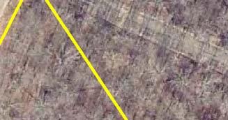
7 Phase I and II Overview Map Gail Lake Timothy City Of Fifty Lakes City Of Emily Little Pine City Of Manhattan Beach Jenkins Ideal City Of Crosslake Fairfield Ross Lake City Of Jenkins City Of Breezy Point Second Assessment City Of Pequot Lakes Mission Perry Lake Pelican Rabbit Lake Wolford City Of Nisswa Lake Edward Center City Of Cuyuna City Of Trommald City Of Crosby City Of Ironton City Of Deerwood City Of Riverton Irondale Deerwood First Assessment Oak Lawn Nokay Lake Bay Lake City Of Brainerd City Of Baxter City Of Garrison Long Lake Maple Grove Garrison Crow Wing Fort Ripley St Mathias Daggett Brook Platte Lake Roosevelt City Of Fort Ripley Road Centerline Phase I Phase II Lakes Township City
 HIDDEN")


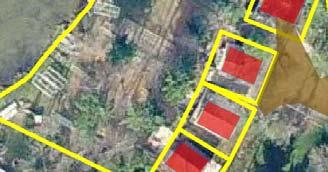

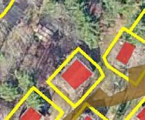

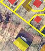
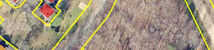


8 CO RD 127 Round ( P) HIDDEN PARADISE RD SUNTAN VILLAGE BURBACK SUNSET VIEW OJIBWA RD Impervious Surfaces (by type) Boathouse Driveway-Cement/Asphalt Driveway-Dirt/Gravel Driveway-Grass Dwelling Garage Miscellaneous CAROLYN LN Patio/Landscaping Shed Roads Parcels Lakes Environmental Services Services Impervious Surfaces - Example Map Feet : THIS DRAWING IS A COMPILATION OF RECORDS AS THEY APPEAR IN THE CROW WING COUNTY OFFICES AFFECTING THE AREA SHOWN AND IS TO BE USED ONLY FOR REFERENCE PURPOSES. THE COUNTY IS NOT RESPONSIBLE FOR ANY INNACCURACIES HERIN CONTAINED.

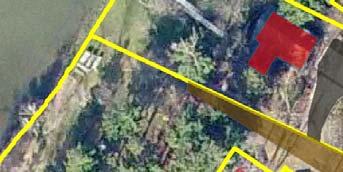
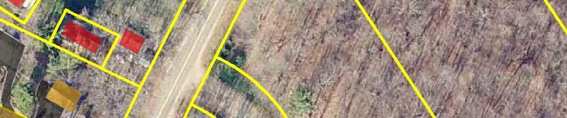
9 Before NOKAY LAKE RD PARK ESTATES DR DWY PARK ESTATES Clearwater (18-38 P) RD After NOKAY LAKE RD PARK ESTATES DR DWY PARK ESTATES Clearwater (18-38 P) RD PARK ESTATES DR PARK ESTATES DR This data is provided on an "AS-IS" basis, without warranty of any type, expressed or implied, including but not limited to any warranty as to their performance, merchantability, or fitness for any particular purpose. Impervious Calculations on Planned Unit Development (PUD) on Clearwater Lake Feet Impervious % within 250 ft of Shoreline Roads 0-15 % Lakes % % 25+ % Parcels
CITY OF INVER GROVE HEIGHTS 8150 Barbara Avenue Inver Grove Heights, MN (651) Fax: (651)
 Fax: (651)") CITY OF INVER GROVE HEIGHTS 8150 Barbara Avenue Inver Grove Heights, MN 55077 (651) 450-2545 Fax: (651) 450-2502 www.invergroveheights.org SKETCH PLAN REVIEW APPLICATION FOR THE NORTHWEST AREA OVERLAY
CITY OF INVER GROVE HEIGHTS 8150 Barbara Avenue Inver Grove Heights, MN 55077 (651) 450-2545 Fax: (651) 450-2502 www.invergroveheights.org SKETCH PLAN REVIEW APPLICATION FOR THE NORTHWEST AREA OVERLAY
Nick Sigmund, Sr. Zoning Officer
 Nick Sigmund, Sr. Zoning Officer Wisconsin Department of Natural Resources Administrative Code NR 115 under the authority of Wisconsin Statute 59.692, establishes and provides that shoreland zoning regulations
Environmental Protection Ordinances (Performance Zoning) Bedminster Township, Bucks County
 Bedminster Township, Bucks County") Environmental Protection Ordinances (Performance Zoning) Bedminster Township, Bucks County ARTICLE VI. PERFORMANCE STANDARDS Section 600 Compliance All uses, activities, subdivisions and/or land developments
Environmental Protection Ordinances (Performance Zoning) Bedminster Township, Bucks County ARTICLE VI. PERFORMANCE STANDARDS Section 600 Compliance All uses, activities, subdivisions and/or land developments
Deb Grube, Sr. Zoning Officer
 Deb Grube, Sr. Zoning Officer Wisconsin Department of Natural Resources Administrative Code NR 115 under the authority of Wisconsin Statute 59.692, establishes and provides that shoreland zoning regulations
Shoreland Zoning. Kay Lutze Shoreland Zoning Policy Coordinator
 Shoreland Zoning Kay Lutze Shoreland Zoning Policy Coordinator Kay.Lutze@wisconsin.gov Purposes of shoreland zoning include Prevent and control water pollution Protect spawning grounds, fish and aquatic
Minnesota Department of Natural Resource - Natural Resource Guidance Checklist Conserving Natural Resources through Density Bonuses
 Minnesota Department of Natural Resource - Natural Resource Guidance Checklist Conserving Natural Resources through Density Bonuses NRDB Why Use Density Bonuses & This Checklist Local units of government
PLANNED UNIT DEVELOPMENT & SUBDIVISION STAFF REPORT Date: May 18, 2017
 & PUD-0000102-2017 PLANNED UNIT DEVELOPMENT & SUBDIVISION STAFF REPORT Date: May 18, 2017 NAME SUBDIVISION NAME Dauphin Creek Estates Subdivision Dauphin Creek Estates Subdivision LOCATION CITY COUNCIL
Design Guidelines and Construction Regulations
 Design Guidelines and Construction Regulations DOVER BAY WATERFRONT RESORT COMMUNITY DOVER BAY PROPERTY OWNERS ASSOCIATION, INC. 120 East Lake Street, Suite 101 Sandpoint, ID 83864 (208) 263-3083 / Fax:
REQUEST FOR COUNCIL ACTION 6A AGENDA ITEM
 DATE REQUEST FOR COUNCIL ACTION 6A AGENDA ITEM ORIGINATING DEPT. AGENDA ITEM CITY ADMINISTRATOR APPROVAL Community Development PUD Concept & Development Stage Plan Preliminary Plat & Final Plat PREVIOUS
UNIFIED DEVELOPMENT CODE
 Zoning UNIFIED DEVELOPMENT CODE Regulates how land is used Sets dimensional requirements for structures Addresses all aspects of site development: accessory structures, temporary uses, parking, landscape,
Ten Mile Creek Planning Area
 PLANNING AREA POLICIES TEN MILE CREEK Ten Mile Creek Planning Area Location and Context The Ten Mile Creek Planning Area ( Ten Mile Creek area ) is located south of the current Boise AOCI, generally south
REQUEST FOR COUNCIL ACTION 6A AGENDA ITEM ORIGINATING DEPT. AGENDA ITEM CITY ADMINISTRATOR APPROVAL
 DATE REQUEST FOR COUNCIL ACTION 6A AGENDA ITEM ORIGINATING DEPT. AGENDA ITEM CITY ADMINISTRATOR APPROVAL Community Development Territorial Greens PUD Concept Plan Development Stage Plan Subdivision (Preliminary
Community LID Workgroup Issue Paper #6
 Community LID Workgroup Issue Paper #6 Topic: Hard and Impervious Surface Coverage Limits Objective: Minimize the amount of hard and impervious surfaces in developments to allow more stormwater to infiltrate
Outflow to Saw Mill Run
 Dormont Stormwater Fee Frequently Asked Questions What is stormwater, and why is it a problem in Dormont? Stormwater is runoff from rain or snow that falls and flows to Little Saw Mill Run or McNeilly
Conservation Development
 Acknowledgements RIDEM: Scott Millar Anthony Lachowicz-Planning and Zoning Consultant Director of Planning 1 : a creative land use technique that allows a community to guide growth to the most appropriate
Landowner's Guide to the Lower St. Croix Riverway. Protect. Restore. Celebrate. stcroixriverassociation.org
 Landowner's Guide to the Lower St. Croix Riverway Protect. Restore. Celebrate. stcroixriverassociation.org Cover and page spread photographs by Craig Blacklock. For more information on how to be a river
RESIDENTIAL PLANNED UNIT DEVELOPMENT / SUBDIVISION AND REZONING CONCEPT AND DEVELOPMENT STAGE PLAN SUBMITTAL NARRATIVE
 RESIDENTIAL PLANNED UNIT DEVELOPMENT / SUBDIVISION AND REZONING CONCEPT AND DEVELOPMENT STAGE PLAN SUBMITTAL NARRATIVE DEVELOPMENT TEAM DONEGAL SOUTH Maple Grove, Minnesota March 27, 2017 Applicant/Developer/Builder:
CHAPTER 4 FUTURE LAND USE AND URBAN SERVICES DISTRICTS
 CHAPTER 4 FUTURE LAND USE AND URBAN SERVICES DISTRICTS Introduction This chapter discusses how Benzie County should grow and change in the future. A community can grow and change in many different ways.
Swatara Township Stormwater Program. 1. There are no storm sewers on or near my property. Why should I pay a fee?
 1. There are no storm sewers on or near my property. Why should I pay a fee? All properties produce stormwater runoff that must be managed by the Township. Even if your property has never flooded and there
PLANNING AND DEVELOPMENT DEPARTMENT SITE PLAN REVIEW SECTION / CURRENT PLANNING APPLICATION FOR PRELIMINARY SITE DEVELOPMENT PLAN APPROVAL
 PLANNING AND DEVELOPMENT DEPARTMENT SITE PLAN REVIEW SECTION / CURRENT PLANNING APPLICATION FOR PRELIMINARY SITE DEVELOPMENT PLAN APPROVAL Project Number City Development Number Application Date (Assigned
Chapter 13: Implementation Plan
 Implementation A. Introduction The Implementation Plan, in table form on the following pages, provides a summary of all the Action Items recommended in Chapters 2 through 12. The table also indicates which
City of East Point Comprehensive Floodplain Management Program
 City of East Point Comprehensive Floodplain Management GAFM 2012, 7 th Annual Technical Conference Reza Aral, CFM, CPESC (City of East Point, GA) Shayne Wood, P.E. (CDM Smith) March, 28, 2012 Agenda Overview
City of Elyria. Frequently Asked Questions
 City of Elyria Stormwater Utility Program Prepared by: April 2014 (version 1) Page 1 City of Elyria Stormwater Utility Program Stormwater Utility Program Q. What is a Stormwater Utility? A. A stormwater
Chapter 10 IMPLEMENTATION RECOMMENDATIONS
 Chapter 10 IMPLEMENTATION RECOMMENDATIONS The recommended land use plan presented in the previous chapter provides a design for the attainment of the urban and rural development and open space preservation
PUD GUIDE FOR THE RED MOUNTAIN RANCH PLANNED UNIT DEVELOPMENT
 PUD GUIDE FOR THE RED MOUNTAIN RANCH PLANNED UNIT DEVELOPMENT Exhibit B to the Annexation and Development Agreement October 15, 2018 *Notes in red are intended for Town of Eagle review purposes and are
Ottawa County Parks, Recreation & Open Space Plan. February, 2006
 2006 Ottawa County Parks, Recreation & Open Space Plan February, 2006 TABLE OF CONTENTS ACKNOWLEDGMENTS.................................................... v PLAN ADOPTION..........................................................vi
Green Infrastructure Policies and Ordinances
 Green Infrastructure Policies and Ordinances October 23, 2013 By Karen Firehock, Green Infrastructure Center 2013 Georgia Urban Forest Council s 23 rd Annual Conference The mission of the nonprofit Green
Draft TISCORNIA ESTATE SPECIFIC PLAN/EIR
 Draft TISCORNIA ESTATE SPECIFIC PLAN/EIR Submitted CONTENTS 1. PLAN SUMMARY II. INTRODUCTION IX. SPECIFIC PLAN RELATIONSHIPS X. XI. List of Figures 1. Regional Location 2. Point Richmond Area 3. Planning
St. Croix County Shoreland Overlay Zoning Districts. Public Hearing Community Development Committee December 19, 2013
 St. Croix County Shoreland Overlay Zoning Districts Public Hearing Community Development Committee December 19, 2013 Timeline CDC Review October 17 Public Information Meeting October 29 (6:00-8:00 pm)
Getting Buy-in: Making the Economic Case for Watershed Planning. Jane Harrison, Ph.D. Coastal Economics Specialist North Carolina Sea Grant
 Getting Buy-in: Making the Economic Case for Watershed Planning Jane Harrison, Ph.D. Coastal Economics Specialist North Carolina Sea Grant Watershed Planning and Protection Obvious environmental benefits
Chesapeake Bay Critical Area Conservation Plan
 The Maryland-National Capital Park and Planning Commission Prince George s County Planning Department Development Review Division 301-952-3530 Note: Staff reports can be accessed at www.mncppc.org/pgco/planning/plan.htm.
APPENDIX A SIMPLIFIED APPROACH TO STORMWATER MANAGEMENT FOR SMALL PROJECTS. In West Sadsbury Township, Chester County, Pennsylvania
 APPENDIX A SIMPLIFIED APPROACH TO STORMWATER MANAGEMENT FOR SMALL PROJECTS In West Sadsbury Township, Chester County, Pennsylvania TABLE OF CONTENTS I. Introduction 3 II. Importance of Stormwater Management
Riverview Road Fort Washington, MD. 163 Waterfront Street, Suite #450 National Harbor, MD (301)
") Riverview Road Fort Washington, MD 163 Waterfront Street, Suite #450 National Harbor, MD 20745 (301) 750-7040 www.fleurdelisllc.com 1 Prepared by Monique Anderson Walker Principal +1 301-750-7040 Monique@FleurDeLisLLC.com
Riverview Road Fort Washington, MD 163 Waterfront Street, Suite #450 National Harbor, MD 20745 (301) 750-7040 www.fleurdelisllc.com 1 Prepared by Monique Anderson Walker Principal +1 301-750-7040 Monique@FleurDeLisLLC.com
METROPOLITAN COUNCIL 390 North Robert Street, St. Paul, MN Phone (651) ; TDD (651)
 ; TDD (651)") DATE: October 24, 2012 METROPOLITAN COUNCIL 390 North Robert Street, St. Paul, MN 55101 Phone (651) 602-1000; TDD (651) 291-0904 TO: Metropolitan Parks and Open Space Commission FROM: Tori Dupre, Senior
DATE: October 24, 2012 METROPOLITAN COUNCIL 390 North Robert Street, St. Paul, MN 55101 Phone (651) 602-1000; TDD (651) 291-0904 TO: Metropolitan Parks and Open Space Commission FROM: Tori Dupre, Senior
STORM WATER UTILITY FREQUENTLY ASKED QUESTIONS
 STORM WATER UTILITY FREQUENTLY ASKED QUESTIONS In 2007, the City Council adopted Ordinance No. 1155 establishing a storm water utility in the City. No fee structure was adopted at that time. The idea of
2.6 Pawtucket. Pawtucket Impervious Cover Map (61.4% Impervious)
") 2.6 Pawtucket Pawtucket Impervious Cover Map (61.4% Impervious) The City of Pawtucket is approximately 8.7 square miles and is heavily residential with some commercial and industrial land. Table 2.14 below
2.6 Pawtucket Pawtucket Impervious Cover Map (61.4% Impervious) The City of Pawtucket is approximately 8.7 square miles and is heavily residential with some commercial and industrial land. Table 2.14 below
Rural Land Use Designations Kittitas County December 6, 2007 Draft
 KITTITAS COUNTY COMMUNITY DEVELOPMENT SERVICES 411 N. Ruby St., Suite 2, Ellensburg, WA 98926 CDS@CO.KITTITAS.WA.US Office (509) 962-7506 Fax (509) 962-7682 Rural Land Use Designations Kittitas County
TOWN OF SPRINGFIELD, NEW HAMPSHIRE
 TOWN OF SPRINGFIELD, NEW HAMPSHIRE NATURAL RESOURCES INVENTORY EXECUTIVE SUMMARY March 2008 Prepared by: Watershed to Wildlife, Inc. Natural Resource Consultants 42 Mill Street, Suite 3 Littleton, NH 03561
PRELIMINARY DRAINAGE REPORT LATHAM 200 MMSCFD GAS PROCESSING PLANT
 PRELIMINARY DRAINAGE REPORT LATHAM 200 MMSCFD GAS PROCESSING PLANT LOTS B, RECORDED EXEMPTION 1211-2-1, RECX13-0096 LOCATED IN THE NORTH 1/2 OF SECTION 2, TOWNSHIP 3 NORTH, RANGE 66 WEST, 6 TH PRINCIPAL
Weston Conservation Commission
 Weston Conservation Commission Commission Roles and Responsibilities Laws that protect Wetlands What residents can do to protect wetlands and open space 1 Conservation Commission Made up of 7 volunteer
A Cooperative Effort Between:
 Lake Shamineau Shoreline Assessment August 2007 A Cooperative Effort Between: Morrison County Planning and Zoning Morrison Soil and Water Conservation District Minnesota Department of Natural Resources
Outfall Retrofit Feasibility Study
 Outfall Retrofit Feasibility Study 2013 APWA-NC SWM Conference September 16-17, 2013 Overview PWD history with outfall retrofits Project setting Review of screening factors and weighting scale QA/QC process
Boardman River Watershed VILLAGE OF KALKASKA. WATER QUALITY ACTION PLAN Fall 2009
 Boardman River Watershed VILLAGE OF KALKASKA WATER QUALITY ACTION PLAN Fall 2009 Partners: The Watershed Center Grand Traverse Bay Northwestern Michigan College - Great Lakes Water Studies Institute Grand
GENERAL INFORMATION What is Stormwater? What is a stormwater utility? What is an impervious surface?
 GENERAL INFORMATION What is Stormwater? Stormwater is rain or snowmelt that falls on streets, parking areas, rooftops, and other developed land and either flows directly into nearby streams or travels
SITE PLAN REVIEW APPLICATION AND CHECKLIST
 SITE PLAN REVIEW APPLICATION AND CHECKLIST PROJECT SUMMARY: Project Name: City/ETA Location: City ETA (Application fee & number of copies needed are based on location) Property Location (Legal Description
ROSS Appendix F Land Conversion. Ecosystem Services Value Lost from Land Conversion in the Central Puget Sound Region ( )
") Ecosystem Services Value Lost from Land Conversion in the Central Puget Sound Region (1992-2011) 1 Purpose The purpose of this study is to estimate, in dollars, the value of annual ecosystem services in
Ecosystem Services Value Lost from Land Conversion in the Central Puget Sound Region (1992-2011) 1 Purpose The purpose of this study is to estimate, in dollars, the value of annual ecosystem services in
We provide exceptional solutions to help our clients achieve success.
 We provide exceptional solutions to help our clients achieve success. We began as a small, two-person surveying firm called M.E. Berry & Associates in Hollywood, Florida. Known today as Calvin, Giordano
Lake O the Pines Master Plan Revision Public Information Meeting April 25 & 27, 2017
 Lake O the Pines Master Plan Revision Public Information Meeting April 25 & 27, 2017 Presented By Matthew Like, Lake Manager U.S. Army Corps of Engineers Fort Worth District US Army Corps of Engineers
SOIL EROSION AND SEDIMENT CONTROL
 SOIL EROSION AND SEDIMENT CONTROL SECTION 1: AUTHORITY, TITLE AND PURPOSE 11. STATUTORY AUTHORIZATION This ordinance is adopted pursuant to the provisions of the Federal Water Pollution Control Act 86
Canyon Lake Master Plan Revision Public Information Meeting March 18, 2016
 Canyon Lake Master Plan Revision Public Information Meeting March 18, 2016 Marcus Schimank Canyon Lake Manager Capital Regional Office U.S. Army Corps of Engineers Fort Worth District US Army Corps of
CMAP Resources for Green Infrastructure Planning
 CMAP Resources for Green Infrastructure Planning Resilient Chicago July 8, 2015 Kate Evasic Associate Planner Chicago Metropolitan Agency for Planning Formed by state law in 2005 to integrate planning
City of Royalton Comprehensive Land Use Plan 2005 to Revision February 8, 2011
 City of Royalton Comprehensive Land Use Plan 2005 to 2015 2011 Revision February 8, 2011 PART ONE: INTRODUCTION TO THE COMPREHENSIVE PLAN 1.0 Purpose and Introduction The Comprehensive Land Use Plan provides
Agenda. Presentation (30 minutes) Overview of RIV District Next Steps / Calendar Display Stations. Display Station Discussion
 Overview of RIV District Next Steps / Calendar Display Stations. Display Station Discussion") Agenda Presentation (30 minutes) Overview of RIV District Next Steps / Calendar Display Stations Display Station Discussion RIV District Overview What is in the District? Purpose & Subdistricts Required
Agenda Presentation (30 minutes) Overview of RIV District Next Steps / Calendar Display Stations Display Station Discussion RIV District Overview What is in the District? Purpose & Subdistricts Required
Proposed Comprehensive Plan Amendments. November 2015 General Referendum
 Proposed Comprehensive Plan Amendments To be considered at the November 2015 General Referendum Draft: June 30, 2015 1. Adopt by reference, The York Village Master Plan, dated April 2015 within Volume
Alan Wertepny MS4 Coordinator September 15, 2011
 Alan Wertepny MS4 Coordinator September 15, 2011 Fertilizer in urban runoff Impacts of excessive nutrients on water bodies Requirements for local government to adopt a fertilizer ordinance Nutrient impaired
HUDSON VALLEY REGIONAL COUNCIL 3 Washington Center, Newburgh NY
 PROJECT AREA: HYDE PARK HUDSON VALLEY REGIONAL COUNCIL 3 Washington Center, Newburgh NY 12550 http://www.hudsonvalleyregionalcouncil Insert aerial site photo with streets labeled GREEN INFRASTRUCTURE CONCEPT
MRCCA PRIMARY CONSERVATION AREAS
 MRCCA PRIMARY CONSERVATION AREAS LOCAL PLANNING HANDBOOK INTRODUCTION MRCCA plans must identify and protect primary conservation areas (PCAs). Primary Conservation Areas (PCAs) are defined in the MRCCA
Exhibit A. 8:9 Scuffletown Rural Conservation District
 Exhibit A 8:9 Scuffletown Rural Conservation District 8:9.1 Intent and Purpose The Scuffletown Rural Conservation (SRC) District is intended to provide for residential development that supports the development
Turf Grass v. Mixed Open
 Turf Grass v. Mixed Open Peter Claggett, U.S. Geological Survey March 8, 2016 Urban Stormwater Workgroup Meeting U.S. Department of the Interior U.S. Geological Survey What s the difference between turf
BISCUIT RUN PARK MASTER PLAN
 BOARD OF SUPERVISORS November 14, 2018 BISCUIT RUN PARK MASTER PLAN COUNTY OF ALBEMARLE ANHOLD ASSOCIATES Contents Project Introduction Property Background County Park Planning Process Existing Site &
RESIDENTIAL STORM WATER PERMIT & CREDIT APPLICATION WORKSHEET AND CHECKLIST
 Engineering Department - Phone: (651) 792-7004 Fax: (651) 792-7040 2660 Civic Center Dr. Roseville, MN 55113 RESIDENTIAL STORM WATER PERMIT & CREDIT APPLICATION WORKSHEET AND CHECKLIST This application
INTRODUCTION. 1.1 What is a General Plan? 1.2 Requirements for a General Plan. 1.3 Introduction to Monterey County
 1.1 What is a General Plan? INTRODUCTION California state law requires each city and county to adopt a comprehensive, long-term general plan for the physical development of the county or city, and any
The Flow. Green Infrastructure Taking Root in Cities 3/23/2015. Green Infrastructure Evolution City Plans/Projects Measureable and Holistic Benefits
 Green Infrastructure Taking Root in Cities Robert Hopper, P.E. CDM Smith The Flow Green Infrastructure Evolution City Plans/Projects Measureable and Holistic Benefits 2 1 Parts, Systems, Whole The first
Chapter 2: Strategies for Local Governments Chapter 3: Site Assessment and Design for Low Impact Development. Break Out Group 10:30 am to 12 pm
 Chapter 2: Strategies for Local Governments Chapter 3: Site Assessment and Design for Low Impact Development Break Out Group 10:30 am to 12 pm A Low Impact Development Manual for Coastal South Carolina
Importance of Master Planning Marcy Colclough
 Importance of Master Planning Marcy Colclough Senior Planner Southwest Michigan Planning Commission WHERE and HOW we develop Land affects Water Quality! 43.2 Acres total 20 Homes 35.8 Acres of open space
Improve Neighborhood Design and Reduce Non Point Source Water Pollution
 HOW TO Planning Guide Improve Neighborhood Design and Reduce Non Point Source Water Pollution This document was funded by a grant from the New Hampshire Coastal Program with funding from the National Oceanic
Regional Freshwater Issues: Stormwater Management and Green Infrastructure April 16, 2011
 Regional Freshwater Issues: Stormwater Management and Green Infrastructure April 16, 2011 New York State Water Resources Institute Emily Vail Hudson River Estuary Program New York State Department of Environmental
Portage County Parks, Trails and Greenways Plan
 Portage County Parks, Trails and Greenways Plan Agenda for Local Planning Meeting Introductory Presentation Why we need a Plan Plan project goals and process Benefits Overview of local planning region
IV. Development in the Rural Overlay District
 Intracoastal Waterway Route 17 Route 168 Great Dismal Swamp VIRGINIA NORTH CAROLINA IV. Development in the Rural Overlay District IV-1 Route 17 in Chesapeake s Rural Overlay District affords distant views
APPLICATION FOR REZONING PROPERTY CITY OF HOLLAND, MICHIGAN. Name of Applicant. Address, and Phone # of Applicant
 APPLICATION FOR REZONING PROPERTY CITY OF HOLLAND, MICHIGAN Name of Applicant Address, Email and Phone # of Applicant Name and Address of Owner (if other than applicant) Ownership Interest of Applicant
Draft Stillwater 2030 Comprehensive Plan- Goals and Policies
 Draft Stillwater 2030 Comprehensive Plan- Goals and Policies Instructions- Review each goal and policy and discuss with group any changes, deletions for additions to the list using your groups pen. Keep
Innovative Land Use Techniques
 Innovative Land Use Techniques A Handbook for Sustainable Development Eric Williams, Assistant Administrator, NHDES Carolyn Russell, Principal Planner, NHDES Cliff Sinnott, Executive Director, RPC Jill
Re: Application Type: Proposed Highlands Redevelopment Area Designation
 CHRIS CHRISTIE Governor KIM GUADAGNO Lt. Governor State of New Jersey Highlands Water Protection and Planning Council 100 North Road (Route 513) Chester, New Jersey 07930-2322 (908) 879-6737 (908) 879-4205
Presented By: Matt Roberts and Cass Chapman The University of Minnesota Law School Environmental Sustainability Clinic
 Presented By: Matt Roberts and Cass Chapman The University of Minnesota Law School Environmental Sustainability Clinic Overview Who We Are and MIDS Project The Problem Recommendations Benefits to Communities
Watertown City Council
 City of Watertown Watertown City Council April 14 th, 2015 Agenda Item: City Comment on Sun Share CUP Application Request for Action: Motion to Approve City Comments regarding CUP Application Department:
Lewisville Lake Master Plan Revision Public Information Meeting May 2 & 4, 2017
 Lewisville Lake Master Plan Revision Public Information Meeting May 2 & 4, 2017 Presented By Rob Jordan Lake Manager U.S. Army Corps of Engineers Fort Worth District US Army Corps of Engineers Purpose
Non-Residential&Multi-Family PropertyCreditManual
 CityofRichmond DepartmentofPublicUtilities StormwaterManagementProgram Non-Residential&Multi-Family PropertyCreditManual ApprovedFebruary2011 City of Richmond Stormwater Non-Residential & Multi-Family
Landscaping Standards
 CHAPTER 29 ARTICLE 403 29.403 Landscaping Standards Purpose: The purpose of this section is to protect and promote the public health, safety and general welfare by requiring landscaping in relation to
Oakland County s Green Infrastructure Vision. L. Brooks Patterson Oakland County Executive
 Oakland County s Green Infrastructure Vision L. Brooks Patterson Oakland County Executive Southeast Michigan 20 miles northwest of Detroit Consists of 910 square miles Population of 1.2 million More than
Chagrin River Watershed Partners, Inc. Local Regulations. Amy H. Brennan (440)
") Chagrin River Watershed Partners, Inc. Local Regulations Amy H. Brennan (440) 975-3870 www.crwp.org abrennan@crwp.org July 9, 2013 Applicable Zoning and Building Codes Erosion and Sediment Control Grading
Chagrin River Watershed Partners, Inc. Local Regulations Amy H. Brennan (440) 975-3870 www.crwp.org abrennan@crwp.org July 9, 2013 Applicable Zoning and Building Codes Erosion and Sediment Control Grading
Procedures IV. V. Rural Road Design Option
 i IV. Procedures A. All applicants required to prepare a Conservation Design Subdivision shall provide the Planning Board with a conceptual conventional subdivision design as well as a proposed layout
Preface. Erie. Scranton. Allentown. Pittsburgh. Harrisburg. Philadelphia
 The Southern Alleghenies Region The Southern Alleghenies Region spans the Laurel Highlands and Allegheny Front in the west across the Appalachians to the east. It is comprised of Blair, Bedford, Cambria,
Information for File # ARC
 Information for File # 2017-00054-ARC Applicant Consultant Corps Contact Linda Keith City of Tower Natalie White SEH Inc. Andrew R Chambers Address 600 South Lake Avenue, Suite 211, Duluth, MN 55802 E-Mail
Mitchell Ranch South MPUD Application for Master Planned Unit Development Approval Project Narrative. Introduction
 Mitchell Ranch South MPUD Application for Master Planned Unit Development Approval Project Narrative Introduction Mitchell Ranch South is a proposed single family (detached) residential development on
Land Use. Chapter 8: Introduction. Land Use Vision. Section I: Current Land Use 8-1
 Introduction Land use is the defining element of the comprehensive plan. It will serve as a framework for decision makers, guiding future growth and development in the Town of Oconto Falls. This chapter
Section H: Waterfront
 Section H: Waterfront Waterfront Designation The waterfront designation describes the shoreline communities, which are located around the lakes or along the significant rivers in the Township. These communities
Tour of Nonpoint Source Pollution Reduction Projects in the Western Lake Superior Watershed
 Tour of Nonpoint Source Pollution Reduction Projects in the Western Lake Superior Watershed On September 8 th, 2006 Minnesota's Lake Superior Coastal Program and the South St Louis Soil and Water Conservation
Urban Sustainability Area Designation
 Urban Sustainability Area Designation City of Santa Cruz October 2013 The City of Santa Cruz Urban Sustainability Area (USA) encompasses the City s business centers and primary transportation corridors
LAMPREY RIVER SUBWATERSHED
 LAMPREY RIVER SUBWATERSHED PISCATAQUA REGION ENVIRONMENTAL PLANNING ASSESSMENT 05 Lamprey River Subwatershed, including: Candia, Deerfield, Epping, Newmarket, Northwood, Nottingham, Raymond www.prepestuaries.org
CITY OF SCANDIA ORDINANCE NO. 174
 CITY OF SCANDIA ORDINANCE NO. 174 AN ORDINANCE AMENDING ORDINANCE NO. 122, THE SCANDIA DEVELOPMENT CODE, CHAPTER 2, SECTION 4.34, REGARDING SOLAR FARMS AND COMMUNITY SOLAR GARDENS The City Council of the
East Whiteland Township Current Land Development Projects
 Current Land Development Projects A. Lincoln Court (Lancaster Avenue / Malin Road) Demolish existing 2 story brick and stucco structure Build onto existing 1 story masonry shopping center to add 8 new
F. The following uses in the HR District: attached single-family dwellings, condominiums, and institutional uses; and
 1102 DESIGN REVIEW 1102.01 PURPOSE AND APPLICABILITY Section 1102 is adopted to provide standards, criteria, and procedures under which design review may be approved. Design review is required for: A.
Mark-up of the effect of the proposed Bronte Village Growth Area OPA No.18 on the text of section 24, Bronte Village, of the Livable Oakville Plan
 Mark-up of the effect of the proposed Bronte Village Growth Area OPA No.18 on the text of section 24, Bronte Village, of the Livable Oakville Plan Notes: This document is provided for information purposes
Proposed Walkability Ordinance for City of Knoxville (6/16/17)
") Proposed Walkability Ordinance for City of Knoxville (6/16/17) New or revised text is highlighted Section 1: Purpose The purpose of this ordinance is to set requirements for walkability and pedestrian
Proposed Walkability Ordinance for City of Knoxville (6/16/17) New or revised text is highlighted Section 1: Purpose The purpose of this ordinance is to set requirements for walkability and pedestrian
Metropolitan Area Planning Council 60 Temple Place, Boston, Massachusetts fax
 Metropolitan Area Planning Council 60 Temple Place, Boston, Massachusetts 02111 617-451-2770 fax 614-482-7185 www.mapc.org Serving the 101 Cities Towns in the Metropolitan Boston Region MEMORANDUM TO:
Joe Pool Lake Master Plan Revision Public Information Meeting May 23, 2017
 Joe Pool Lake Master Plan Revision Public Information Meeting May 23, 2017 Presented By Jason Owen Lake Manager U.S. Army Corps of Engineers Fort Worth District US Army Corps of Engineers Purpose of this
2. Would the proposed project comply with the Land Use map? 3. Would the proposed project require a rezoning? 4. What is the proposed zoning district?
 TOWN OF CHAPEL HILL Planning and Sustainability Department 405 Martin Luther King Jr. Blvd. Chapel Hill, NC 27514 www.townofchapelhill.org phone (919) 968 2728 Concept Plans are intended to be an opportunity
Low Impact Development. Charlene LeBleu Auburn University Landscape Architecture (334)
") Low Impact Development Charlene LeBleu Auburn University Landscape Architecture leblecm@auburn.edu (334) 844-0192 What is Low Impact Development? Infiltrate Filter Store Evaporate Detain An innovative
Low Impact Development Charlene LeBleu Auburn University Landscape Architecture leblecm@auburn.edu (334) 844-0192 What is Low Impact Development? Infiltrate Filter Store Evaporate Detain An innovative
ARTICLE V PLANNED UNIT DEVELOPMENT DISTRICT
 ARTICLE V PLANNED UNIT DEVELOPMENT DISTRICT A. Purpose and Objective The Planned Unit Development (PUD) procedure provides a flexible land use and design regulation through the use of performance criteria
Climate Smart Communities Green Infrastructure Case Studies
 New York State Water Resources Institute Climate Smart Communities Green Infrastructure Case Studies Emily Vail Hudson River Estuary Program NYS Department of Environmental Conservation Cornell University