City of Eau Claire 2015 Development Map and Report
|
|
|
- Christal Page
- 5 years ago
- Views:
Transcription


1 City of Eau Claire 2015 Development Map and Report Department of Community Development Eau Claire, Wisconsin


2 City of Eau Claire 2015 Development Map and Report Fairfield Inn and Suites 1666 Princeton Crossing Oxbow Hotel Galloway Street Department of Community Development Eau Claire, Wisconsin Cover Photos: Haymarket Landing 202 Eau Claire Street Lismore Hotel 205 South Barstow Street
3 2015 DEVELOPMENT AND REPORT TABLE OF CONTENTS Page INTRODUCTION I. DEVELOPMENT ACTIVITY FOR II. OVERVIEW OF SELECTED DEVELOPMENT INFORMATION SINCE III. IMPLEMENTATION OF COMPREHENSIVE PLAN IV. POPULATION AND HOUSING UNIT ESTIMATES V DEVELOPMENT MAP... 26
4 LIST OF MAPS Page 1. DEVELOPMENT MAP: CITY SECTORS... Introduction 2. EAU CLAIRE LAND USE PLAN DEVELOPMENT MAP...26
5 INTRODUCTION
6 INTRODUCTION The 2015 Development Map and Report have been prepared by the City of Eau Claire, Department of Community Development, to summarize 2015 land development activity for the City as a whole and by sectors of the City which are illustrated on Map 1 and described in an accompany table. A similar map and report has been prepared since 1980 to provide a record of annual development and to assist in monitoring the growth and development of the City of Eau Claire. In addition, these development maps and reports will be used to evaluate the effectiveness of the City of Eau Claire Comprehensive Plan. It should be noted that the City sector boundaries used in the report were adjusted in 1987 to coincide with U.S. Census tract boundaries. This change enables the comparison of development data with census statistics. The major components of the report and map include: annexation, zoning changes, subdivisions, and building activity. The following is a brief description of these components: ANNEXATIONS The Development Report lists annexation activity by the town from which the land was annexed, the size of the land involved, the population and number of housing units within the area, and the sector in which it is located. The Development Map identifies the annexations approved in 2015 with the capital letter A and a subscripted number referring to the table on pg. 1. REZONINGS The Development Report lists rezoning activity by what the initial zoning of the property was, what the property was rezoned to, the size of the land involved, and the sector in which it is located. The Development Map identifies the rezonings approved in 2015 with the capital letter Z and a subscripted number referring to the table on page 1. SUBDIVISIONS The Development Report lists subdivision activity by subdivision name, size of the area subdivided, number of lots subdivided, zoning of the property, and sector in which it is located. The Development Map identifies the subdivisions approved in 2015 with the capital letter S and a subscripted number referring to the table on pg. 1.
7 BUILDING ACTIVITY The Development Map displays and the Development Report summarizes building activity for which permits were issued during In addition, stateowned facilities which are not required to obtain a City building permit prior to construction are added into the values reported for public and semi-public construction occurring in a particular year. In the City of Eau Claire, most of the projects which do not require a building permit are those on the University of Wisconsin-Eau Claire campus. Following are the criteria for the recording of building permits on the Development Map and in the Development Report. Residential Construction Permits for the construction of new housing units have been recorded in three categories: single-family, condominium, duplex, and multiple-family. The Development Map indicates the number of housing units included in each multiple-family project. Remodeling projects, alterations, or additions to residential structures are not shown on the map or summarized in the report. Non-residential Construction Permits issued for non-residential construction have been recorded in three categories commercial (retail) and office; industrial and warehouse; and public and semi-public (includes all tax-exempt property, major UW-EC projects which did not require a permit and utilities). The non-residential construction tabulations include both new construction and remodeling; however, projects having a value of less than $10,000 (typically, minor alterations) are not shown on the map or summarized in the report. Demolitions All permits for the demolition of structures which were issued during 2015 are included in the report, along with the number of dwelling units lost through the demolition of residential structures. Finally, the Development Report is organized into four parts. Part I summarizes land development activity for the City as a whole and for each of the four sectors of the City. Part I also provides a general summary of building activity for the City as a whole, including a listing of major building projects (value of $100,000 or more) for which building permits were issued in Part II provides a brief overview of the City s development activity since Part III reports how well growth and development activity in 2015 in the City of Eau Claire has complied with the Land Use Plan, which is an element of the City s Comprehensive Plan. Part IV contains current estimates of population and number of housing units in
8 the city. Development activity (particularly annexations, subdivisions, residential building permits, and demolition permits) is used to keep population and housing unit figures current. As did previous reports, development that occurred in 2015 is reviewed in relation to the City's Land Use Plan which is a chapter of the City s Comprehensive Plan, with the goal that land use and development decisions are made in accordance with the Comprehensive Plan. The Development Map and Report will help the City annually monitor its compliance with the Comprehensive Plan, by becoming a more accurate and detailed record of development activity and population growth for the City of Eau Claire.
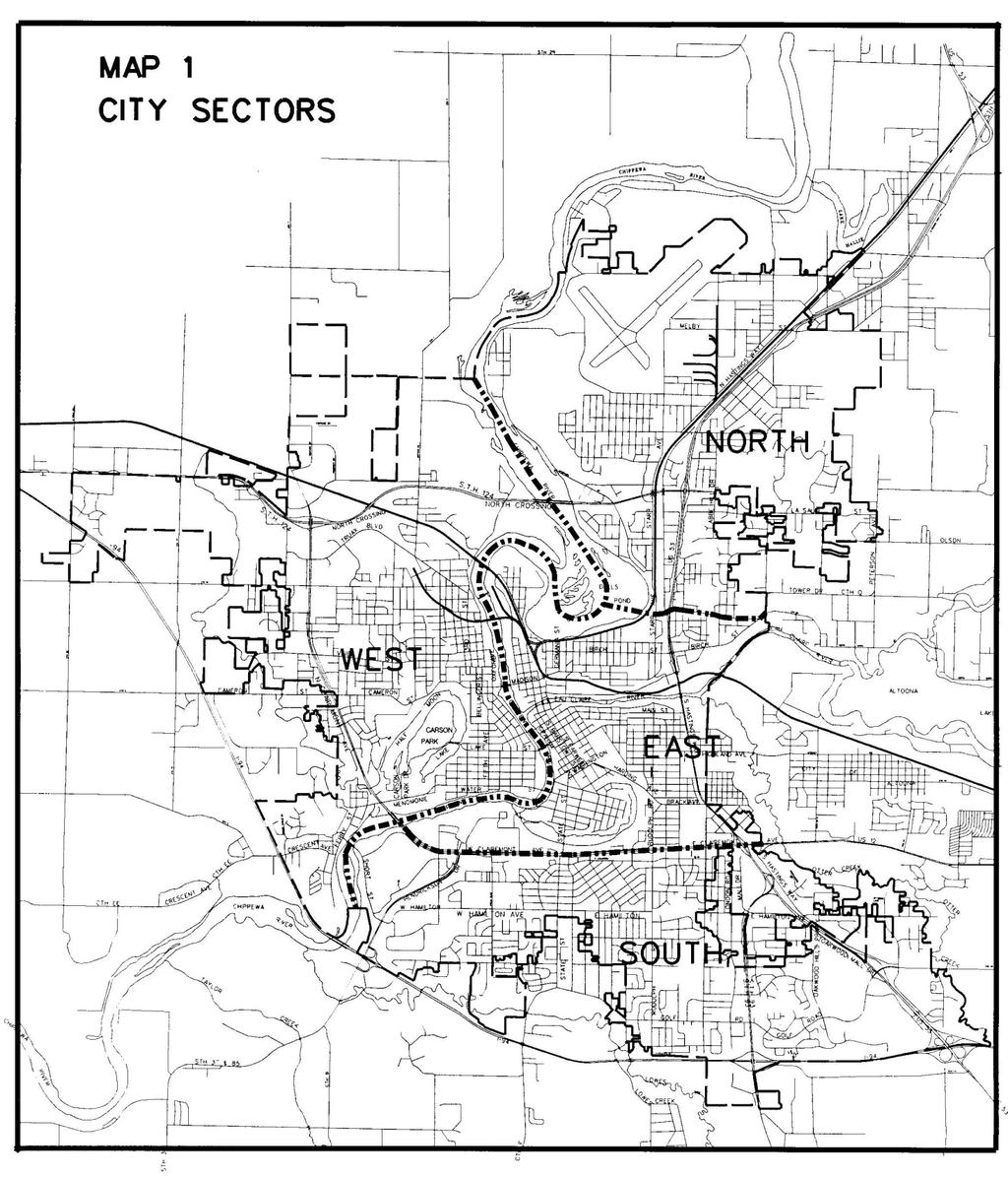
9 DESCRIPTION OF CITY SECTORS NORTH: SOUTH: Land east of the Chippewa River and north of a line created by Seymour Road extended, Seymour Road, N. Shore Drive, N. Shore Drive extended, and the Eau Claire River. Land east of the Chippewa River and south of Clairemont Avenue and Hwy. 12. EAST: Land south of Seymour Road extended, Seymour Road, N. Shore Drive, N. Shore Drive extended, and the Eau Claire River and which is east of the Chippewa River and north of Clairemont Avenue. WEST: Land located west of the Chippewa River.
10
11 PART I DEVELOPMENT ACTIVITY FOR 2015
12 I. ANNEXATIONS Map # File # Sector Town Housing Units Population Area Annexed (acres) A A North Seymour A A South Washington A A South Washington A A South Washington A A South Washington Total II. REZONINGS Map # Sector Original Zoning Approved Zoning Area Rezoned (acres) File # Approval Date Z-1 North R-1 & R-3 R-3P 4.3 Z /10/2015 Z-2 East C-3 C-2P 0.8 Z /22/2015 Z-3 South TC-3 C-3P 4.5 Z /25/2015 Z-4 South C-3 C-3P 1.1 Z /10/2015 Z-5 South TR-1 R Z /27/2015 Z-6 South TR-1A R Z /10/2015 Z-7 South TR-1A C-2P 3.3 Z /13/2015 Z-8 South C-3P R-3P 6.7 Z /22/2015 Z-9 South I-1 C-3P 2.6 Z /13/2015 Z-10 West RMP C-2P 1.3 Z /22/2015 Z-11 West R-3 & R-4 R-2 & RMP 92.4 Z /12/2015 Z-12 West P R-3P 0.7 Z /27/2015 Z-13 West TR-1A R Z /24/2015 Total III. SUBDIVISIONS Map # File # Sector Name Area Subdivided (acres) # of Lots/Units Zoning Date Approved S-1 P-2-15 South Hidden Meadows R-1 6/9/2015 Phase 1 S-2 P-4-07 West Westridge Village 2nd R-3P 4/14/2015 Add S-3 P-2-13 West Aspen Meadows II R-2P 4/14/2015 Total
13 IV. BUILDING CONSTRUCTION A. General Summary 1. Permit Breakdown Type # of Permits Plumbing 604 Signs 175 Heating 591 Building 985 Total 2, Building Demolition Permits # of Permits Type Principal Structure Accessory Structure Residential 16* 5 Commercial 6 0 Industrial 2 2 Public 0 0 Total 24 7 *Includes the demolition of 19 dwelling units. 2
14 3. Conditional Permits Type # of Permits Zoning appeals 7 Conditional use permits 18 Site plan review Non-residential Construction Projects ($100,000 or more in value) Commercial/Office (41 projects) NAME ADDRESS DESCRIPTION VALUE ($) SECTOR Haymarket Concepts LLC 202 Eau Claire St Confluence Mixed Use Building with 119 units $29,000,000 east Lismore Hotel 205 S Barstow St 94,635 Sq Ft Alteration To Existing Hotel $12,125,475 east Marshfield Clinic Inc 2116 Craig Rd Healing And Rehab Center Addition To Marshfield Clinic $8,000,000 east Princeton Lodge LLC 1666 Princeton Crossing New 53,557 Sq Ft Hotel $6,000,000 north Mohr Growth Investments LLC 2909 Lorch Ave 3454 Sq Ft Quick Lane Addition And Alterations at Eau Claire Ford $2,800,000 south Northern States Power Co 1414 W Hamilton Ave 16,841 Sq Ft Interior Remodel $2,605,300 south Longform LLC 516 Galloway St 18,300 Sq Ft Hotel Remodel Oxbow Hotel $1,491,000 east Keystone Corp 4027 Commonwealth Ave 23,088 Sq Ft Interior Build Out For Ross Dress For Less $990,000 south Doro Of Eau Claire 2910 Golf Rd New Hardee's Restaurant $800,000 south Do The Beer LLC Midelfort Clinic Bldg Partnership 3560 Oakwood Mall Dr 733 W Clairemont Ave 5150 Sq Ft Remodel For Monk's Bar And Grill $800,000 south MCC 733 Family Care Expansion, 3265 Sq Ft $718,000 south Keystone Corp 3402 Oakwood Mall Dr 8315 Sq Ft Tenant Build Out For Miron Construction Company, Inc $709,650 south Longform LLC 508 Galloway St 6700 Sq Ft Remodel To Existing 2 Story Hotel Oxbow Hotel $639,000 east DGI Eau Claire LLC 2530 Birch St New Dollar General Store $592,000 east KT Real Estate Holdings LLC 2135 Brackett Ave 400 Sq Ft Interior Remodel Including Changing Jimmy John's Into Kitchen Area $500,000 east Oakwood Hills Mall LLC 4800 Golf Rd Space 312, 8677 Sq Ft Interior Alteration For Victoria Secret $425,000 south 3
15 Kwik Trip Inc 3360 Birch St 2500 Sq Ft Interior Remodel $400,000 east KDS Properties LLC 2779 S Hastings Way New Southward Insurance Office Building $395,000 south Midelfort Clinic Bldg Partnership 733 W Clairemont Ave Mcc 733 2nd Floor Bathroom And Family Practice Rescheduling Area $369,917 south Lazy Monk Brewing LLC 97 W Madison St 7860 Sq Ft Interior And Exterior Remodel For Lazy Monk $358,000 west Eau Claire Land Acquisitions LLC 3200 Mall Dr Redo Exterior with Eifs New Rubber Roof Over Portion Of Building $331,000 south Chippewa Valley Tech College 620 W Clairemont Ave Room 32 And Corridor Upgrades $328,000 east First Federal Savings & Loan Of La Crosse 1107 Regis Ct 3715 Sq Ft Second Level Remodel And Wheelchair Lift $300,000 east CVFE LLC 2159 Brackett Ave 1850 Sq Ft Addition To Accommodate New Temporary Dome At Wagner's $300,000 east RTST Inc 2504 Truax Blvd Building Shell For New 2726 Sq Ft Mixed Use Building $285,000 west Four Sisters LLC rd St Interior Alterations To Existing Building To Create New Restaurant $250,000 west Keystone Corp 3440 Oakwood Hills Pkwy 4200 Sq Ft Interior Build Out For Acadia Healthcare $250,000 south Midelfort Clinic Bldg Partnership 733 W Clairemont Ave Employee Entry Canopy And Misc. Interior Remodeling To Accommodate $247,114 south Jean M Hebert 4710 Commerce Valley Rd Unit 1 Build Out Basement For Dental Clinic $243,000 south Kachmar Holdings LLC 405 S Barstow St 3482 Sq Ft Interior Remodel For New Sushi Restaurant $240,000 east Oakwood Hills Mall LLC 4800 Golf Rd Space #289, Interior Alterations For Rue 21 $230,000 south ETD Development LLC 2056 S Hastings Way 2200 Sq Ft Interior And Exterior Remodel $225,000 east Chippewa Valley Tech College 620 W Clairemont Ave Interior Remodel To Accommodate HVAC Work, Replace Lower Well $219,500 east Wells Fargo Bank 310 Graham Ave 2900 Sq Ft Interior Remodel $209,730 east Midelfort Clinic Bldg Partnership 727 Kenney Ave MCC 727 Public Restrooms $178,565 south Market & Johnson Inc 2350 Galloway St Remodel Office Space $150,000 east Pablo Properties LLC 215 Riverfront Ter 1345 Sq Ft First Floor Interior Remodel For Qbe Tenant Space $135,268 east RTST Inc 2504 Truax Blvd 1264 Sq Ft Build Out For Jimmy John's $135,000 west 4
16 Lismore Hotel 210 S Farwell St Alterations To Include New Toilet Rooms In First Floor Lobby. $123,675 east Oakwood Hills Mall LLC 4800 Golf Rd 2074 Sq Ft Alteration For Space AT&T $100,000 south LMS Partnership 5400 Old Town Hall Rd Remodel Existing Office Space $100,000 south Industrial/Warehouse (15 projects) NAME ADDRESS DESCRIPTION VALUE ($) SECTOR FedEx 2435 Prospect Dr New 163,714 Sq. Ft. FedEx Distribution Facility $7,300,000 west Boxer Properties II LLC 3339 Fehr Rd New Student Transit Warehouse And Office $4,500,000 south Gerber Products Company 1200 Nestle Ave 8260 Sq Ft Lab Addition $3,148,512 west Kurz Eau Claire LLC 2665 Fortune Dr New 19,407 Sq Ft Factory Building $2,483,011 west Goodin Co 3542 Hogarth St 25,410 Sq Ft Addition To Warehouse $1,100,000 north Farrell Investments LLC 2315 Western Ave New 45,000 Sq Ft Warehouse $994,900 north Lee Beverage Co 2714 Melby St 15,750 Sq Ft Storage Addition $667,000 north Eau Claire County Airport 3800 Starr Ave 9048 Sq Ft New Hanger For Menards $500,000 north Eau Claire County Airport 3800 Starr Ave 9048 Sq Ft New Hanger For Menards $500,000 north Eau Claire County Airport 3800 Starr Ave 9048 Sq Ft New Hanger For Menards $500,000 north Duane E Dingmann 2459 Morningside Dr New 11,720 Sq Ft Warehouse On Existing Foundation $400,000 east Gerber Products Company 1200 Nestle Ave Crawl Structure For New Storage Tanks $250,000 west 2020 Tambo LLC 2020 Prairie Ln 34,606 Sq Ft Interior Alteration Of Show Room And Tenant 1 Spaces Gerber Products Company 5023 Venture Dr Tear Off Existing Roof System Down To Vapor Barrier. Install 2 Layers Of 2 $150,000 west $102,646 west Lee Beverage Co 2714 Melby St 2204 Sq Ft Office Expansion Into Storage Area $100,000 north 5
17 Public/Semi-public (10 projects) NAME ADDRESS DESCRIPTION VALUE ($) SECTOR City Of Eau Claire 303 Galloway St New 182,355 Sq Ft 3 Story Parking Ramp $8,543,000 east Sacred Heart Hospital 900 W Clairemont Ave Emergency Department Triage Remodel (7500 Sq Ft) $1,828,000 east Sacred Heart Hospital 900 W Clairemont Ave Build-Back After Demo Of Professional Office Building $1,117,000 east Luther Hospital - Mayo Clinic Health System 1221 Whipple St Lower Level Lab Relocation-Phase 2 $565,000 west Sacred Heart Hospital 900 W Clairemont Ave East Side Administration Wing Curtain Wall Replacement $489,000 east Luther Hospital - Mayo Clinic Health System 1400 Bellinger St Mb W Orthopedics Offices - Exams $370,000 west Covenant Healthcare Of Eau Claire 1405 Truax Blvd 1st Floor Renovation For Dove Healthcare West $360,000 west Chippewa Valley Tech College 4000 Campus Rd 48 X 30 Greenhouse $129,000 west Clinicare Corp 550 N Dewey St Remove Existing Ballest Rock And Recover $102,705 east Chippewa Valley Tech College 4000 Campus Rd New Solar Thermal And Electric Rack, Solar Tracker, And Roof Mounted Solar Hot Water $102,340 west 6
18 B. New Residential Construction City of Eau Claire # of Units Sector Single-family Condominium Duplex Multi-family Total North South East West Total NEW RESIDENTIAL CONSTRUCTION NUMBER OF UNITS NORTH SOUTH EAST WEST SECTOR Single-family Condominium Duplex Multi-Family 7


19 Valuation ($) Sector Single-family Condominium Duplex Multi-family Total North 2,176, , ,596,000 South 5,551, ,029, ,580,374 East 125, * 125,000 West 6,991,244 2,590, ,000 1,512,000 11,414,002 Total 14,843,368 2,590,758 1,769,250 1,512,000 20,715,376 Notes: 1. Does not include the valuation for the 119-unit mixed use project at 202 Eau Claire Street. That valuation is included in the commercial category. $200,001 OR MORE 51% NUMBER OF NEW 2015 SINGLE FAMILY DWELLINGS BY VALUE 0-$100,000 2% 34 DU. $100,001- $125,000 6% 1 D.U. 4 D.U. 9 D.U. 18 D.U. $125,001- $150,000 14% $150,001- $200,000 27% 8
20 C. Non-residential Construction (projects $10,000 or more in value) City of Eau Claire # of Permits Sector Comm./Office Industrial/Warehouse Public/Semi-public Total North South East West Total NON-RESIDENTIAL CONSTRUCTION Projects of $10,000 or more # OF PERMITS North South East West SECTOR Comm./Office Industrial/Warehouse Public/Semi-Public 9
21 Valuation ($) Projects of $10,000 or more Sector Comm./Office Industrial/Warehouse Public/Semi-public Total North 6,151,440 4,745,225 57,000 10,953,665 South 13,332,755 4,590,000 70,355 17,993,110 East 55,405, ,000 12,218,005 68,023,939 West 1,305,401 13,487,296 1,958,861 16,751,558 Total 76,195,530 23,222,521 14,304, ,722, NON-RESIDENTIAL CONSTRUCTION VALUATION Projects of $10,000 or more VALUATION (in millions of dollars) North South East West SECTOR Comm./Office Industrial/Warehouse Public/Semi-Public 10
22 PART II OVERVIEW OF DEVELOPMENT INFORMATION SINCE 1995
23 OVERVIEW OF SELECTED DEVELOPMENT INFORMATION SINCE 1995 I. ANNEXATION Total Number 18 21* * Total Area (acres) Population Sq. Mi. of City at Year End (minus any detachments) *Includes detachment NOTE: Adjustment in sq. mi. made in 2003 based on computer calculations of city area. Areas for previous years back to 1991 were also adjusted. II. REZONINGS Total Number Total Area (acres) III. SUBDIVISIONS Total Number Total Area (acres) # of Lots units 3 bldgs 86 lots D.U. 3 com tenant suites lots 22 D.U
24 IV. BUILDING CONSTRUCTION (No. of Units) Single-family Condominium 48* Duplex Multiple-family Total ** 129 *** 234 *Prior to 2004, condominium dwellings were included in the single-family totals. **Does not include 32-unit CBRF at 3325 Birch Street. ***Does not include 20-unit CBRF at 3337 Birch Street. 12
25 SINGLE FAMILY CONSTRUCTION # OF UNITS *Includes single family units and condomimiums YEAR 13
26 DUPLEX CONSTRUCTION NUMBER OF UNITS YEAR MULTIPLE FAMILY CONSTRUCTION NUMBER OF UNITS YEAR 14
27 SINGLE-FAMILY HOUSING COSTS Year Average Price for a New Home , , , , , , , , , , , , , , , , , , , ,900 AVERAGE COST OF A NEW SINGLE FAMILY DWELLING $224, , ,000 VALUE ($) 150, ,000 50,000 0 YEAR 15
28 # OF PERMITS/VALUATION ($) ($10,000 or more) Year Commercial/Office Industrial/Warehouse Public/Semi-Public /27,401,403 40/30,173,416 32/14,534, /11,675,007 26/28,226,912 27/8,808, /18,360,629 28/7,984,674 28/7,191, /36,441,167 36/12,796,923 28/36,463, /25,133,384 40/20,051,884 28/7,902, /23,801,407 29/43,378,629 36/40,135, /21,249,147 29/3,874,250 36/11,752, /14,488,984 23/6,041,780 25/43,316, /35,214,213 17/3,340,690 21/15,789, /20,523,365 17/13,493,150 30/16,581, /24,630,337 18/31,859,930 36/24,068, /49,297,271 22/3,473,266 25/27,512, /23,766,531 15/3,919,311 47/39,677, /33,607,309 20/17,097,550 29/23,784, /12,234,748 13/17,384,000 30/127,194, /20,849,897 22/6,872,301 46/21,279, /17,258,204 12/3,912,436 40/117,053, /23,408,254 10/6,731,500 55/73,451, /37,824,985 24/4,398,513 31/61,613, /20,931,331 20/4,457,317 35/16,610, /76,195,530 26/23,222,521 25/14,304,221 16
29 TOTAL CONSTRUCTION VALUATION Year Value ($) ,060, ,900, ,856, ,979, ,124, ,551, ,375, ,433, ,926, ,455, ,568, ,334, ,977, ,310, ,280,069* ,031, ,560, ,720, ,649, ,447, ,460,800 *Note: This is an all-time record for the City! 250,000,000 TOTAL ANNUAL CONSTRUCTION VALUATION $154,460, ,000,000 VALUE ($) 150,000, ,000,000 50,000,000 0 YEAR 17
30 PART III IMPLEMENTATION OF COMPREHENSIVE PLAN
31 The annual Development Map and Report have two primary purposes. The first is to report the year s development activity for the City and provide comparisons to development activity from previous years. Secondly, the report aids the City in implementing the City s Comprehensive Plan. This section of the report deals specifically with tracking how well the City s growth and development achieves the goals of the Plan. The Comprehensive Plan is a general guide for the physical development of the City. As a guide, the City Plan Commission and City Council use it in making decisions regarding annexations, rezonings, plats, the sizing and timing of various public improvements and in the review of private development proposals. Previous reports, dating back to 1982 initially based its review on the City s Comprehensive Plan, which was adopted in In 1993, the City prepared a new Comprehensive Plan, which this report then used to track and monitor development. The Plan was updated in 2005 and most recently in The 2015 plan includes fourteen chapters, including: land use, transportation, natural resources, parks, urban design, economic development, public utilities, community facilities, housing, historic preservation, downtown, neighborhoods, intergovernmental cooperation, and plan implementation. This report will take a general look at the annual development activity in relation to each chapter of the Comprehensive Plan, but will focus on the goals and policies contained in the Land Use Chapter. Specifically, the report will monitor development activity in relation to the Planned Land Use Map (Map 2). The purpose of the Land Use Chapter and Map are to establish a general pattern for continued physical development for the City. It addresses the locations of housing, businesses, industry, and parks and serves as a basis for the zoning ordinance and the zoning map, which control the use of the land and design of specific sites. In order to determine conformance with the Land Use Chapter, this report will review rezonings and major non-residential development projects, which have a value of $100,000 or more for conformance with the Plan. In addition, the siting criteria for multiple-family development, which is contained in the Plan, will be used to evaluate the placement of multiple-family projects in the City. 18

32 19 Map 2
33 The City approved 13 rezoning applications in A summary of these rezonings can be found in the first section of this report and are also shown on the development map. All were in conformance with the Planned Land Use Map. In addition, 66 major ($100,000 or more) non-residential projects were granted building permits. These projects are listed in the first chapter of this report. All of this development was in conformance with the development pattern identified in the Planned Land Use Map. Finally, the Land Use Chapter states that the City consider the following criteria when reviewing development proposals for medium to high-density housing: Adequate utility and street capacity The ability of a given area or neighborhood to absorb additional density Adequate access Transit service Proximity to services and employment opportunities Proximity of schools and natural amenities Compatibility with adjacent development Suitability of the site for construction In 2015, building permits were issued for 5 projects having 4 or more units. The following chart illustrates whether each of these projects satisfied the locational criteria contained in the Plan. 20
34 LOCATIONAL CRITERIA # of Units Adequate Utility & Street Capacity Ability of Area to Absorb Additional Density Adequate Access Transit Service Proximity to Services & Employment Opportunities Proximity to Schools Proximity to Neighborhood Park Areas Compatibility with Adjacent Development Suitability of Site for Construction 2227 Peters Drive 4 Yes Yes Yes Yes Yes Yes Yes Yes Yes 2307 Peters Drive 4 Yes Yes Yes Yes Yes Yes Yes Yes Yes th Street 10 Yes Yes Yes Yes Yes Yes Yes Yes Yes 811 Chippewa Street 4 Yes Yes Yes Yes Yes Yes Yes Yes Yes 202 Eau Claire Street 119 Yes Yes Yes Yes Yes No Yes Yes Yes Total
35 PART IV POPULATION AND HOUSING UNIT ESTIMATES
36 For general planning purposes, it is important to keep track of the annual growth or decline in city population and number of housing units. The number of persons and the number of housing units are related to various types of development activity, including annexations, subdivisions, new residential construction, and residential demolitions. These development factors may be used to maintain a current estimate of population and housing units in the City of Eau Claire. HOUSING UNIT ESTIMATES The 2010 U. S. Census has published data relating to households and vacancy status for the City of Eau Claire. The table below summarizes this information for each of the four sectors within the city. Sector # of Occupied Dwelling Units # of Vacant Dwelling Units Total Dwellings % Vacant Average Household Size North 4, , South 7, , East 6, , West 7, , Total 26,330 1,589 27, Source: 2010 U.S. Census & American Community Survey The annual housing unit estimates represent the sum of (number of housing units at the beginning of the year + number of housing units added per year through new construction + number of housing units added per year through annexations) (number of housing units lost per year through residential demolition and those moved out of the city). The annual housing estimates do not include the number of units added or lost each year through the conversion of existing structures. Housing Units on Housing Units on Housing Units on Housing Units on Net 2014 Net 2015 Net Sector Change Change Change North 4, , , ,871 South 8, , , ,192 East 7, , , ,579 West 8, , , ,329 Total 28, , , ,971 22
37 POPULATION ESTIMATES The City s 2010 population was 65,883. This is an increase of 4,179 persons since 2000 when the population was 61,704. This increase represents an average annual increase of 418 persons or a growth rate of approximately.68 percent per year. This compares to an annual growth rate of.85 percent that occurred during the 90s. Based on figures from the U.S. Census Bureau, the following graph illustrates how the City s population has changed since The table below shows the population changes by decade since POPULATION CHANGE ,509 56,866 61,704 65,883 POPULATION (in thousands) ,267 30,745 36,058 37,987 44, YEAR 23
38 Year Population % Rate of Growth , , , , , , , , , , , , , , , Source: United States Census Bureau The Wisconsin Department of Administration also provides population estimates for the City. The most current estimate available from the State is for January 1, As of this date, the State estimates Eau Claire s population at 67,
39 POPULATION & HOUSEHOLD PROJECTIONS Population and household projections are a prerequisite to planning, as population and household growth or decline determines the level of demand for various land uses, facilities, and services. For this reason, these projections for the City of Eau Claire are an important component of development monitoring Population Projection 69,225 70,895 72,255 73,095 73,770 Household Projection 28,909 29,821 30,586 31,128 31,442 The projections provided above were prepared by the Wisconsin Department of Administration, Demographic Services Center, in December, 2014, and April, ,000 City of Eau Claire Population Projections 73,095 73,770 # of Persons 70,000 69,225 70,895 72,255 65, Year Source: WI Dept. of Administration 25
40 PART V 2015 DEVELOPMENT MAP


41 U.S DEVELOPMENT MAP HIGHWAY 29 S.T.H. 124 HIGHWAY 29 S.T.H TH ST Single Family - Detached Annexations C.T.H. J 8 Condominium Unit Duplex C.T.H. TT Multiple Family Structure (and # of units per permit) C.T.H. T 30TH AVE Subdivisions C.T.H. F Rezonings 80TH AVE IONA BEACH RD CHIPPEWA RIVER 26TH AVE 105 ST LAKE HALLIE HAGEN RD C.T.H. J 24TH AVE Commercial & Office* Industrial & Warehouse* 20TH AVE Feet PJI C.T.H. F AIRPORT RD SUNDET RD ROBIN RD BEAN RD JOLES AVE * C.T.H. EE Public & Semi Public Projects* * Valuation of $10,000 or more COUNTY LINE RD C.T.H. TT C.T.H. T S-3 10TH AVE E RIVERVIEW DR NORTH LA STARR AVE WHITE AVE ANDERSON DR MELBY ST N. HASTINGS WAY LOCUST LN MELBY ST 118TH ST 53 FREEWAY RIVERVIEW DR EDDY LA Z-1 50TH AVE HIGHWAY 12 CHIPPEWA RIVER PIEDMONT RD ABBE HILL DR S.T.H. 312 S.T.H. 312 MARQUETTE ST BURNELL DR I-94 C.T.H. EE C.T.H. CC Z-15 S-2 FOLSOM ST * * PRESTON DR Z-14 N. CLAIREMONT AVE. FOLSOM ST 4 4 MOHOLT DR * FOURTEENTH ST JEFFERS RD TRUAX BLVD SEVENTH ST Z-16 WELLS ROAD NORTH CROSSING DELLS POND S.T.H. 312 STARR AVE WESTERN AVE N. HASTINGS WAY ABBE HILL DR SEYMOUR RD BROOKLINE AVE * MCKINLEY RD LASALLE ST TOWER RD C.T.H. QQ A-1 PETERSON AVE C.T.H. Q OLSON DR C.T.H. E C.T.H. C C.T.H. TT I-94 CAMERON ST W MENOMONIE ST VINE ST Z-13 CRESCENT AVE N. CLAIREMONT AVE. FERRY ST CAMERON ST HALF MOON LAKE MENOMONIE ST Z * Z-10 HALF MOON LAKE * VINE ST THIRD ST Z-11 4 CHIPPEWA RIVER BELLINGER ST CHIPPEWA RIVER EAU CLAIRE RIVER LAKE ALTOONA C.T.H. EE CHIPPEWA RIVER GROVER RD S.T.H. 37 I-94 S.T.H. 85 MITCHELL RD S.T.H. 37 C.T.H. B WATER ST 5TH AVE W. CLAIREMONT AVE. MADISON ST * * ** * 119 ** * * STATE ST SHORT ST HENDRICKSON DR CRAIG RD HAMILTON AVE LOWES CK RD PRIORY RD C.T.H. F W. GRAND AVE LAKE ST FIRST AVE * GRAHAM AVE DEWEY ST FARWELL ST S BARSTOW ST GALLOWAY ST BIRCH ST MAIN ST HARDING AVE LEXINGTON BLVD MARGARET ST Z-2 * HIGHLAND AVE FENWICK AVE BRACKETT AVE RUDOLPH RD KEITH ST S. HASTINGS WAY BIRCH ST GALLOWAY ST FAIRFAX ST E. CLAIREMONT AVE. SPOONER AVE RIVER PRAIRIE CROSSING Z-3 HIGHWAY 53 TENTH ST TENTH ST TENTH ST E. CLAIREMONT AVE. LAKE RD THIRD ST C.T.H. KK NORTH SHORE DR US HWY 12 Z-9 STEIN BLVD MACARTHUR AVE A-5 STATE ST * NIMITZ ST MITSHER AVE RUDOLPH RD SKEELS AVE * FAIRFAX ST LONDON RD S. HASTINGS WAY S.T.H. 93 Z-4 Z-7 A-2 Z-6 A-3 A-4 OAKWOOD HILLS PKWY S-1 E. HAMILTON AVE Z-5 GATEWAY DR C.T.H. AA DAMON ST GOLF RD LONDON RD S.T.H. 93 GOLF RD * Z-8 I-94 I-94 LOWES U.S. 53 CREEK RD S.T.H. 93 C.T.H. II C.T.H. II
City of Eau Claire 2013 Development Map and Report
 City of Eau Claire 2013 Development Map and Report Department of Community Development Eau Claire, Wisconsin City of Eau Claire 2013 Development Map and Report R.D. Larson Business Center 3402 Oakwood
The Eau Claire Revitalization Story. April 17, Traffic Engineering Workshop and Transportation Planning Forum Pewaukee, Wisconsin
 The Eau Claire Revitalization Story April 17, 2018 2018 Traffic Engineering Workshop and Transportation Planning Forum Pewaukee, Wisconsin Overview Downtown Redevelopment Public Response to Redevelopment
2017 Commercial Real Estate Market Report
 2017 Commercial Real Estate Market Report BROKERAGE DEVELOPMENT PROPERTY MANAGEMENT www.commonwealdc.com A message from our President: Stuart M. Schaefer President Dear Friends and Colleagues: Thank you
Planning Districts INTRODUCTION
 INTRODUCTION To facilitate detailed examination of development prospects for all areas of the community, Delano has been divided into 14 planning districts. The location of these planning districts is
The Eau Claire Revitalization Story. March 2, 2018 WCMA Conference
 The Eau Claire Revitalization Story March 2, 2018 WCMA Conference The City of Eau Claire was founded on a site at the confluence of the Eau Claire and Chippewa Rivers Early Industry was Lumber/Sawmills
Land Use. 3. Fringe Development Pattern: What land use pattern should the City seek to achieve on its perimeter?
 The Land Use Chapter provides guidance for public and private decisions about the future use of land and the structures built upon the land. The chapter addresses all land currently within the City, as
EAU CLAIRE CITY COUNCIL AGENDA TUESDAY, SEPTEMBER 13, 2016 CITY HALL COUNCIL CHAMBER PLEDGE OF ALLEGIANCE AND ROLL CALL CONSENT AGENDA
 EAU CLAIRE CITY COUNCIL AGENDA TUESDAY, SEPTEMBER 13, 2016 CITY HALL COUNCIL CHAMBER PLEDGE OF ALLEGIANCE AND ROLL CALL 4:00 P.M. CONSENT AGENDA The following matters may be acted upon by the City Council
UW System Board of Regents Capital Planning and Budget Committee October 4, 2012 THE CONFLUENCE PROJECT
 UW System Board of Regents Capital Planning and Budget Committee October 4, 2012 Overview Current Conditions Current Collaborations Geography Lesson Project and Partners Operating Information Current Conditions
Mycoskie McInnis Associates represented by Cliff Mycoskie. Rdw Rudy s Arlington and I-20/South Collins, Ltd represented by Robert Dorazil
 Case Information Applicant: Property Owner: Sector Plan: Mycoskie McInnis Associates represented by Cliff Mycoskie Rdw Rudy s Arlington and I-20/South Collins, Ltd represented by Robert Dorazil East Council
EAU CLAIRE, WISCONSIN REQUEST FOR PROPOSALS
 EAU CLAIRE, WISCONSIN REQUEST FOR PROPOSALS North Barstow Redevelopment District 2 South Barstow Project The Eau Claire Redevelopment Authority is requesting proposals for the development/redevelopment
M E M O R A N D U M July 27, 2018
 M E M O R A N D U M July 27, 2018 To: Southlake 2035 Corridor Planning Committee From: Kenneth Baker, Sr. Director of Planning and Development Services Subject: Item #6 First National Bank Purpose Review,
Town of Castle Rock DRCOG 2013 Annual Growth and Development Report. Introduction. Section 1 Metro Vision 2035
 Town of Castle Rock DRCOG 2013 Annual Growth and Development Report Introduction This is the Town of Castle Rock s sixth annual report to the Denver Regional Council of Governments (DRCOG) reporting on
Pr ofil e. City of Altoona. Eau Claire County, Wisconsin DEMOGRAPHICS. Date Printed: February 6, 2017 Page 1 of 2 POPULATION *
 Pr ofil e, Wisconsin DEMOGRAPHICS POPULATION Source: U.S. Census *Estimate 2010 2016* 6,706 7,345 98,736 101,731 5,686,986 5,753,250 HOUSING Number of Housing Units 2011-2015 2,983 42,708 2,635,602 2011-2015
Park, Open Space, & Recreation Facilities Plan
 2018-2022 Park, Open Space, & Recreation Facilities Plan Adopted by the Eau Claire City Council on May 22, 2018 Department of Community Services Eau Claire, Wisconsin 2018 2022 Park, Open Space, & Recreation
Eau Claire County Mission Statement:
 (1) Indicates 1 st Reading (2) Indicates 2 nd Reading 1. Call to Order AGENDA Eau Claire County Board of Supervisors Tuesday, May 19, 2015 / 7 pm Location: County Boardroom, 1 st Floor Courthouse, Room
Jason D. Sutphin, Community Development Division Chief. Through: Brooke Hardin, Director of Community Development and Planning
 Meeting Date: 12/18/2017 Agenda Item: 9a. MEMORANDUM To: Chairman Cunningham and Members of the Planning Commission From: Jason D. Sutphin, Community Development Division Chief Through: Brooke Hardin,
KNOXVILLE/KNOX COUNTY METROPOLITAN PLANNING COMMISSION
 KNOXVILLE/KNOX COUNTY METROPOLITAN PLANNING COMMISSION FILE #: 12-A-13-UR AGENDA ITEM #: 33 AGENDA DATE: 12/12/2013 APPLICANT: OWNER(S): METRO KNOXVILLE HMA, LLC Metro Knoxville HMA., LLC TAX ID NUMBER:
Chapter 10 IMPLEMENTATION RECOMMENDATIONS
 Chapter 10 IMPLEMENTATION RECOMMENDATIONS The recommended land use plan presented in the previous chapter provides a design for the attainment of the urban and rural development and open space preservation
Community PROFILE. City of Altoona. Eau Claire County, Wisconsin DEMOGRAPHICS. Page 1 of 2 POPULATION * City of Altoona
 Community PROFILE DEMOGRAPHICS, Wisconsin POPULATION Source: U.S. Census *Estimate 2010 2018* 6,706 7,682 98,736 102,816 5,686,986 5,816,231 HOUSING Number of Housing Units 2013-3,241 43,422 2,668,692
General Location Annex, Rezone & Preliminary Plat Lansdowne Addition, Unit Three
 NEWFOUNDLAND I-5 Agricultural District Subject Site SUNDANCE ANDERSON Single Family Residential CHRISTY PUD Agricultural District Highway Business General Location Annex, Rezone & Preliminary Plat Lansdowne
Offering Memorandum Commercial Opportunity Acre Parcel Zoned MU-OI-1/R-3
 Offering Memorandum Commercial Opportunity 44.78-Acre Parcel Zoned MU-OI-1/R-3 North Chapel Hill off Weaver Dairy Road CH North Shopping Center Perkins Dr Chapel Hill North Apartments ABC Store Synergy
Eau Claire State of the City Kerry Kincaid City Council President January 15, 2010
 Eau Claire State of the City 2010 Kerry Kincaid City Council President January 15, 2010 Thank you to The people who helped prepare this message Dagmar Bechel-Machyckova Julie Casteen Pat Ivory Mike Huggins
AWH REPORT OF THE PLANNING AND DEVELOPMENT DEPARTMENT FOR APPLICATION FOR REZONING ORDINANCE TO PLANNED UNIT DEVELOPMENT
 AWH REPORT OF THE PLANNING AND DEVELOPMENT DEPARTMENT FOR APPLICATION FOR REZONING ORDINANCE TO PLANNED UNIT DEVELOPMENT MAY 8, 2014 The Planning and Development Department hereby forwards to the Planning
M E M O R A N D U M November 9, 2018
 M E M O R A N D U M November 9, 2018 To: Southlake 2035 Corridor Planning Committee From: Kenneth Baker, Sr. Director of Planning and Development Services Subject: Item #8 Up to thirteen (13) residential
EXHIBIT A. Tax Increment Reinvestment Zone No. 1 (Town Center) First Amended Project Plan 1
 First Amended Project Plan 1") EXHIBIT A Tax Increment Reinvestment Zone No. 1 (Town Center) First Amended Project Plan 1 1 As amended by Resolution No. 2008-02-001(TR1R) of the Tax Increment Reinvestment Zone No.1, and approved to
EXHIBIT A Tax Increment Reinvestment Zone No. 1 (Town Center) First Amended Project Plan 1 1 As amended by Resolution No. 2008-02-001(TR1R) of the Tax Increment Reinvestment Zone No.1, and approved to
ARLINGTON COUNTY, VIRGINIA
 ARLINGTON COUNTY, VIRGINIA County Board Agenda Item Meeting of January 23, 2016 DATE: January 12, 2016 SUBJECT: SP #335 SITE PLAN AMENDMENT to permit modifications to the outdoor cafe and transportation
Access to the University of North Carolina at Chapel Hill, UNC Hospitals, and Chapel Hill Transit.
 M 1/ 4 1/ 2 E IL M E IL Station Family: County: City: UNC Hospitals WHY THIS STATION? University Village Orange Chapel Hill Access to the University of North Carolina at Chapel Hill, UNC Hospitals, and
Type Permit Description Permits Fee Collected Valuation Units Bldgs
 City of Laredo Monthly Report for February Type Permit Description Permits Fee Collected Valuation Units Bldgs HOUSEKEEPING BUILDING 101 *Single Family Detached 95 $ 67,309.50 $ 14,682,859.00 95 102 *Single
Small Area Plan. South Gateway
 Small Area Plan Adopted May 12, 2008 South Gateway Purpose. The South Gateway Small Area Plan defines the City s expectations for the future of the southern entrance to the City at Interstate 85 and Highway
WATQ-FM, WBIZ-AM, WBIZ-FM, WMEQ-AM, WMEQ-FM & WQRB-FM EEO PUBLIC FILE REPORT August 1, 2016 July 31, 2017 I. VACANCY LIST
 August 1, 2016 July 31, 2017 I. VACANCY LIST See Section II, the Master Recruitment Source List ( MRSL ) for recruitment source data. Job Title Recruitment Sources ( RS ) Used to Fill Vacancy RS Referring
KNOXVILLE/KNOX COUNTY METROPOLITAN PLANNING COMMISSION SUBDIVISION REPORT - CONCEPT/USE ON REVIEW
 KNOXVILLE/KNOX COUNTY METROPOLITAN PLANNING COMMISSION SUBDIVISION REPORT - CONCEPT/USE ON REVIEW FILE #: 10-SF-17-C 10-I-17-UR AGENDA ITEM #: 12 AGENDA DATE: 11/9/2017 POSTPONEMENT(S): 10/12/2017 SUBDIVISION:
Dwelling Units Max 12 dwelling units per acre/min 8 dwelling units per acre. Development Mix 80% non residential/20% residential
 13. OSTEEN LOCAL PLAN Background: The Osteen Local Plan area is located in southwest Volusia County along the SR 415 corridor between Lemon Bluff Road and Acorn Lake Road and includes 3,990 acres. The
SECTION UNIFIED DEVELOPMENT ORDINANCE SECTION Part 1 Ordinance. ARTICLE 1 Zoning Districts
 SECTION 1-100 UNIFIED DEVELOPMENT ORDINANCE SECTION 1-300 Part 1 Ordinance SECTION 1-100. Introduction. ARTICLE 1 Zoning Districts Crystal Lake strives to maintain a balance of various land uses for a
Arlington & Putnam Heights, Dells Park & Riverview, and Upper Westside Neighborhoods
 City of Eau Claire, Wisconsin Arlington & Putnam Heights, Dells Park & Riverview, and Upper Westside Neighborhoods Including the Southeast Portion of the Third Ward Neighborhood, 1300-1400 Blocks of Hoover
Today Land & People. Northeast Nampa Gateway District. Employment. Land Use Characteristics. Demographics. Current Zoning
 Today Land & People Employment Major employers include Saint Alphonsus, the College of Western Idaho, the Auto Mall, Sorrento Lactalis and Walmart. 3,004 jobs in 2010 (COMPASS-CIM 2040 TAZ data) 4,345
2.0 AREA PLANS. Lakeside Business District. Lakeside Business District Land Use Categories:
 Lakeside Business District Lakeside Business District Land Use Categories: Campus Commercial Campus Commercial means a mixture of uses which includes corporate offices, office parks, hotels, commercial,
Glenborough at Easton Land Use Master Plan
 Land Use Framework November 30, 2007 2.0 LAND USE FRAME- WORK 2.1 LAND USE HISTORY and Setting Glenborough at Easton is located on property that was used for mining in the 19th and 20th centuries and rocket
FOR LEASE McCarran Marketplace S. Eastern Ave. / Las Vegas, NV Property Highlights. Great Ingress/Egress. National Tenant Mix
 FOR LEASE Property Highlights ±560,000 SF Walmart & Lowe s Anchored Power Center Available Space: ±-3,174 SF Endcap Available with Potential Patio Opportunity 2nd Generation Restaurant Space Available
Mariposa Lakes. Planned Community. Project Overview. Stockton, CA
 Planned Community Stockton, CA Project Overview March 2007 Summary of Proposed Community is a master-planned community proposed for development on approximately 3,810 acres in southeast Stockton. In 2004,
City of Laredo Building Development Services Department Monthly Report for May Type BUILDING PERMITS Permits Fee Collected Valuation Units Bldgs
 Monthly Report for May Type BUILDING PERMITS Permits Fee Collected Valuation Units Bldgs HOUSEKEEPING BUILDING 101 *Single Family Detached 105 $ 71,117.00 $ 15,431,619.00 105 102 *Single Family Attached
ASPEN HILL Minor Master Plan Amendment
 ASPEN HILL Minor Master Plan Amendment Project Briefing Planning Board Agenda Item #7 Andrea Gilles, Area 2 June 5, 2014 Briefing Purpose 1. Follow-up evaluation on Mixed-Use land use in the Minor Amendment
E O L A F I V E. Location Map SUMMARY G M P Z O N I T E M S # 1 A. & B.
 N. Eola Drive Staff Report to the Municipal Planning Board August 18, 2015 G M P 2 0 1 5-0 0 0 1 9 Z O N 2 0 1 5-00016 I T E M S # 1 A. & B. A N X 2 0 1 2-0 0 0 0 5 G M P 2 0 1 2-0 0 0 0 6 Z O N 2 0 1
SECTION ONE: INTRODUCTION. introduction
 introduction 1 INTRODUCTION Since it was first established in 1843 as a trading post for the Hudson s Bay Company, Victoria has evolved into a Provincial capital city that is recognized across Canada and
3424 Chicago Drive Hudsonville, MI 49426
 NEW HUDSONVILLE DEVELOPMENT Coming November 2018 3424 Chicago Drive Hudsonville, MI 49426 COLLIERS INTERNATIONAL 333 Bridge Street NW, Suite 1200 Grand Rapids, MI 49504 +1 616 774 3500 www.colliers.com/westmichigan
10 Year Family Dollar NNN Lease - Rare Urban location
 505-4 0 1-0 1 3 5 O w n e r / B r o k e r 505-6 1 0-1 6 5 5 O w n e r / B r o k e r 10 Year Family Dollar NNN Lease - Rare Urban location A c t u a l P r o p e r t y P h o t o Sale Price: $2,000,000 NOI:
EXECUTIVE SUMMARY DRAFT CHAPTER 1 INTRODUCTION EXECUTIVE SUMMARY
 CHAPTER 1 EXECUTIVE SUMMARY INTRODUCTION Through the joint efforts of the City of Tulsa planning staff and the Land Services division of Indian Nations Council of Governments (INCOG), the Berryhill Land
Type BUILDING PERMITS Permits Fee Collected Valuation Units
 Type BUILDING PERMITS Permits Fee Collected Valuation Units HOUSEKEEPING BUILDING 101 *Single Family Detached 73 $ 46,852.50 $ 9,849,014.00 73 102 *Single Family Attached 103 *2 Family Building 104 *3
Rezoning Petition Final Staff Analysis June 18, 2018
 Rezoning Petition 2018-028 Final Staff Analysis June 18, 2018 REQUEST Current Zoning: MX-1 LLWPA (mixed use district, Lower Lake Wylie Protected Area), R-3 LLWPA (single family residential, Lower Lake
ARLINGTON COUNTY, VIRGINIA
 ARLINGTON COUNTY, VIRGINIA County Board Agenda Item Meeting of July 21, 2012 DATE: July 12, 2012 SUBJECT: SP #416 SITE PLAN AMENDMENT to modify condition #6 to eliminate requirement to provide a pedestrian
East Central Area Plan
 East Central Area Plan Steering Committee Meeting March 8 th, 2018 CHUN Tears McFarlane House Vision Statement Development Opportunities Analysis Vision Elements 1. Equitable, Affordable and Inclusive
Spatial Areas of Practice AICP EXAM REVIEW. February 20, 2009 Georgia Tech Student Center Gary A. Cornell, FAICP
 Spatial Areas of Practice AICP EXAM REVIEW February 20, 2009 Georgia Tech Student Center Gary A. Cornell, FAICP Acknowledgement Thanks to Mary M. Shaw, AICP Planning at the National Level Federalism in
Gold Line Bus Rapid Transit Transit Oriented Development (BRTOD) Helmo Station Area Plan
 Helmo Station Area Plan") Appendix F Gold Line Bus Rapid Transit Transit Oriented Development (BRTOD) Helmo Station Area Plan Introduction and Purpose of the Plan The Gold Line Bus Rapid Transit facility is an eleven-mile dedicated
Appendix F Gold Line Bus Rapid Transit Transit Oriented Development (BRTOD) Helmo Station Area Plan Introduction and Purpose of the Plan The Gold Line Bus Rapid Transit facility is an eleven-mile dedicated
Historic District Commission
 Historic District Commission Page 1 of 14 Staff Report January 2 nd, 2018 ADMINISTRATIVE ITEMS / OLD BUSINESS: Administrative Approvals: 1. 454 Middle Street - Recommend Approval 2. 24 Johnson Court -
Staff Report and Recommendation
 Community Planning and Development Planning Services 201 W. Colfax Ave., Dept. 205 Denver, CO 80202 p: 720.865.2915 f: 720.865.3052 www.denvergov.org/cpd TO: City Council Neighborhoods and Planning Committee
Land Use. Hardware Street Vendor Mixed-Use
 Land Use Definition Land Use is the way a piece of real estate is utilized. Existing, proposed, and adopted land uses all play a role in the planning process. Once a land use plan is adopted, the next
Plan Goals. Protect existing residential neighborhoods.
 Plan Goals Protect existing residential neighborhoods. Develop the vacant areas to the highest potential, in a quality manner, to provide an increase in tax base and services for residents. Provide pathways
Colerain Township report to. Hamilton County Regional Planning Commission. December 2, 2010, 1:00PM. t a f f r e p o r t
 Colerain Township report to Hamilton County Regional Planning Commission December 2, 2010, 1:00PM Preliminary Plan: Case No.: ZA2001-04, Forevergreen Prepared By: Amy Bancroft, Land Use Planner t a f f
The Ritz-Carlton, Paradise Valley
 The Ritz-Carlton, Paradise Valley 7000 E. Lincoln Drive Keys to Success Community Conversation II June 4, 2015 RITZ-CARLTON PARADISE VALLEY Town Council Study Session June 4, 2015 General Plan 2012 Land
Lake Davidson Village. Langtree Road - Exit 32 Mooresville, North Carolina
 Langtree Road - Exit 32 Mooresville, North Carolina Executive Summary: Lake Davidson Village is located at Exit 32 interchange at Langtree Road and Interstate 77. This new interchange is the first exit
PRELIMINARY REPORT. HIGHWAY 18 CORRIDOR NEIGHBORHOOD PLAN VILLAGE OF DOUSMAN November, 2014
 PRELIMINARY REPORT HIGHWAY 18 CORRIDOR NEIGHBORHOOD PLAN VILLAGE OF DOUSMAN November, 2014 This preliminary report presents the initial recommendations for land use within the Highway 18 corridor along
Planning & Zoning Commission Staff Report
 Planning & Zoning Commission Staff Report Meeting Date: May 26, 2015 Drafted by: Katherine Harrison-Rogers CASE # Z2886 PROJECT NAME: APPLICANT/ REPRESENTATIVE: Shawna Runyan PROPERTY OWNER: 1840 (previously
SOUTH NATOMAS COMMUNITY PLAN
 SOUTH NATOMAS Community Plan Part Three : COMMUNITY PLAN AREAS AND SPECIAL STUDY AREAS SACRAMENTO 2030 GENERAL PLAN Contents Community Location... 3-SN-3 Community Vision... 3-SN-4 Community Profile...
Existing Conditions Summary (Draft for Review)
") Existing Conditions Summary (Draft for Review) Prepared by March 16, 2015 Bird s-eye-view of Norwalk in 1899 (Cropped) Existing Conditions Summary (Draft for Review) March 16, 2015 Table of Contents 1.
Existing Conditions Summary (Draft for Review) Prepared by March 16, 2015 Bird s-eye-view of Norwalk in 1899 (Cropped) Existing Conditions Summary (Draft for Review) March 16, 2015 Table of Contents 1.
40 Years of Smart Growth Arlington County s Experience with Transit Oriented Development in the Rosslyn-Ballston Metro Corridor
 40 Years of Smart Growth Arlington County s Experience with Transit Oriented Development in the Rosslyn-Ballston Metro Corridor A presentation by the Arlington County Department of Community Planning,
Downtown Dubuque...it s a great time.
 Downtown Dubuque...it s a great time. Your timing could not be better to invest in Downtown. With hundreds of millions in public and private investment occurring on the City s downtown waterfront, millions
UNIVERSITY OF MICHIGAN:
 Chapter Eight UNIVERSITY OF MICHIGAN: North Campus I. Introduction The University of Michigan currently owns approximately 800 acres of land in the northeast section of Ann Arbor. North Campus refers to
IMPLEMENTATION STRATEGIES. In This Chapter. Goals & Strategies 182 Project List 183 Future Land Use 186 CHAPTER 11 IMPLEMENTATION STRATEGIES
 In This Chapter Goals & Strategies 182 Project List 183 Future Land Use 186 11 IMPLEMENTATION STRATEGIES NORTH AUGUSTA, SC 2017 COMPREHENSIVE PLAN 179 Individual commitment to a group effort that is what
Urban Development Areas Bedford County
 5 Urban Development Areas Bedford County UDA Needs Profile: All UDAs Bedford County has designated two UDAs: areas just outside the Bedford City Limits (generally to the south and east of the city) and
WILLISTON CROSSING. Williams County, North Dakota MAJOR COMPREHENSIVE PLAN AMENDMENT PRESENTATION 01/27/2015
 WILLISTON CROSSING Williams County, North Dakota MAJOR COMPREHENSIVE PLAN AMENDMENT PRESENTATION 01/27/2015 Williston Crossing, located in northwest North Dakota, is an exciting mixed use development planned
Walnut Creek BART Station
 Walnut Creek BART Station Mixed Use Transit Oriented Project Design Review Commission Study Session May 17, 2006 Applicant: Walnut Creek Transit Lifestyles Associates Joint Venture: Transit Village Associates
Joint Meeting City Council and the Plan Commission. September 1st, 2015
 Joint Meeting City Council and the Plan Commission September 1st, 2015 1 The City Plan Commission shall recommend a City Plan for the physical development of the City Article IX Section 2 of the City of
DRAFT ETC Master Plan. Appendix D Land Uses and Demographics
 DRAFT ETC Master Plan Appendix D Land Uses and Demographics DRAFT ETC Master Plan Figure D 1. Existing Land Uses... D 3 Figure D 2. Future Land Uses... D 5 Figure D 3. Transportation Analysis Zones...
LOS ANGELES CITY PLANNING DEPARTMENT STAFF REPORT
 LOS ANGELES CITY PLANNING DEPARTMENT STAFF REPORT LOS ANGELES CITY PLANNING COMMISSION CASE NO: CPC 2006-9374 CRA CEQA: Exempt DATE: December 21, 2006 Location: Valley Plaza and Laurel Plaza TIME: after
What Pioneer Grove Will Look Like?
 The City of Deerfield Beach has embarked on a journey to create a new town center within the old heart of Deerfield Beach. The new town center is known as Pioneer Grove. Pioneer Grove will be Everybody
WHAT MAKES A GREAT PLACE?
 ARCHITECTURAL QUALITY ARCHITECTURAL QUALITY IN THE CORRIDOR ARCHITECTURAL QUALITY The Potential of a Multimodal Terminal Would bring provide alternate forms of transportation to Atlanta s major destinations
Economic Redevelopment of Underutilized Parcels. May 16, 2012 Northland Arboretum Brainerd, Minnesota
 Economic Redevelopment of Underutilized Parcels May 16, 2012 Northland Arboretum Brainerd, Minnesota Matt Glaesman City of St. Cloud Community Development Director 1. A Tradition of Change 2. Why Now?
Michigan City Alternative Analysis Realignment Study. Progress Status Update Report Presentation to City Council February 1, 2012
 Michigan City Alternative Analysis Realignment Study Progress Status Update Report Presentation to City Council Project Web Site Project Web Site is Active www. emichigancity.com Click on NICTD logo at
A citizen s guide to the. Comprehensive Plan. City of Lakeville, Minnesota 1
 A citizen s guide to the Comprehensive Plan 2008 City of Lakeville, Minnesota 1 Introduction The City of Lakeville completed an update of its Comprehensive Plan in 2008. A comprehensive plan is a tool
40 Years of Smart Growth Arlington County s Experience with Transit Oriented Development in the Rosslyn-Ballston Metro Corridor
 40 Years of Smart Growth Arlington County s Experience with Transit Oriented Development in the Rosslyn-Ballston Metro Corridor A presentation by the Arlington County Department of Community Planning,
Transporta on Resource Guide
 Transporta on Resource Guide Need A Ride? there are a wide variety of transporta on op ons available in Eau Claire County. Ride the bus! The City of Eau Claire operates a fixed route bus system, u lizing
Request Conditional Use Permit (Car Wash Facility) Staff Recommendation Approval. Staff Planner Jonathan Sanders
 Staff Recommendation Approval. Staff Planner Jonathan Sanders") Applicant Property Owner SunTrust Bank Public Hearing October 10, 2018 City Council Election District Princess Anne Agenda Item 2 Request Conditional Use Permit (Car Wash Facility) Staff Recommendation
Applicant Property Owner SunTrust Bank Public Hearing October 10, 2018 City Council Election District Princess Anne Agenda Item 2 Request Conditional Use Permit (Car Wash Facility) Staff Recommendation
CITY OF DEERFIELD BEACH Request for City Commission Agenda
 Item: CITY OF DEERFIELD BEACH Request for City Commission Agenda Agenda Date Requested: April 2, 2013 Contact Person: Gerald R. Ferguson, Director of Planning & Development Services Description: 3317,
Type BUILDING PERMITS Permits Fee Collected Valuation Units
 Type BUILDING PERMITS Permits Fee Collected Valuation Units HOUSEKEEPING BUILDING 101 *Single Family Detached 52 $ 35,754.00 $ 7,854,726.00 52 102 *Single Family Attached 1 $ 699.00 $ 152,418.00 1 103
Zoning Interface: Districts and Forms for Sioux Falls Zoning Ordinance
 Zoning Interface: Districts and Forms for Sioux Falls Zoning Ordinance For more information about each form, click on the associated link. Single-Family Residential Districts RR Rural Residential RS Single-Family
TREASURE COAST REGIONAL PLANNING COUNCIL M E M O R A N D U M. To: Council Members AGENDA ITEM 5H
 TREASURE COAST REGIONAL PLANNING COUNCIL M E M O R A N D U M To: Council Members AGENDA ITEM 5H From: Date: Subject: Staff October 17, 2008 Council Meeting Local Government Comprehensive Plan Review Draft
CITY COUNCIL STAFF REPORT
 COUNCIL AGENDA: 04/11/17 ITEM: W\0^ CITY OF e: :SS SAN JOSE CAPITAL OF SILICON VALLEY CITY COUNCIL STAFF REPORT File No. C16-030 Applicant: Alex Rubashevsky Location Northwest corner of Oakland Road and
M E M O R A N D U M January 6, 2017
 Item #4 M E M O R A N D U M January 6, 2017 To: 2035 Corridor Planning Committee From: Kenneth Baker, Sr. Director of Planning and Development Services Subject: Item #4 Overview Fidelis Purpose: Review
Eau Claire Comprehensive Plan 2015 Urban Design Assessment
 Eau Claire Comprehensive Plan 2015 Urban Design Assessment City of Eau Claire Wisconsin Major Urban Design Issues... 9-1 Accomplishments since the 2005 Comprehensive Plan... 9-3 Factors Affecting Urban
STUDY AREA LOCATION & CONTEXT:
 UNLOCKING THE POTENTIAL OF THE KEATING CROSS ROAD BUSINESS CORRIDOR A PLAN TO CREATE + RETAIN JOB-GENERATING BUSINESSES AND TO GUIDE INFRASTRUCTURE INVESTMENT The Keating Cross Road Corridor (the Keating
Glenborough at Easton Land Use Master Plan
 Vision Statement Sunrise Blvd. Hazel Ave. Prairie City Rd. Gencorp Property Lincoln Regional Airport 1.0 VISION STATEMENT The identifies City of the principles, goals, policies, and standards Lincoln that
Developer s Program. The Station at East 54
 Developer s Program The Station at East 54 Existing Conditions The Station at East 54 is proposed for a 1.12 acre site at the northeast corner of Hamilton Road and Prestwick Road, tucked between the East
Rezoning Petition Pre-Hearing Staff Analysis July 16, 2018
 Rezoning Petition 2018-044 Pre-Hearing Staff Analysis July 16, 2018 REQUEST Current Zoning: R-3 (single family residential) Proposed Zoning: UR-2(CD) (urban residential, conditional) LOCATION Approximately
2014: A Year in Review
 The State of Our City is Strong AAA Bond Rating Highest Possible Rating Happiest City in America National Bureau for Economic Research Most Exciting Place in VA Movoto Real Estate New American Foodie Cities
City of Royalton Comprehensive Land Use Plan 2005 to Revision February 8, 2011
 City of Royalton Comprehensive Land Use Plan 2005 to 2015 2011 Revision February 8, 2011 PART ONE: INTRODUCTION TO THE COMPREHENSIVE PLAN 1.0 Purpose and Introduction The Comprehensive Land Use Plan provides
SUNSET CORRIDOR LAND. The property is now available and ready for corporate utilization, development or investment.
 SUNSET CORRIDOR LAND The property is now available and ready for corporate utilization, development or investment. This 275-acre site is now available and ready to develop. Just off US 26, this west Sunset
Rezoning Petition Pre-Hearing Staff Analysis May 21, 2018
 Rezoning Petition 2018-028 Pre-Hearing Staff Analysis May 21, 2018 REQUEST Current Zoning: MX-1 LLWPA (mixed use district, Lower Lake Wylie Protected Area), R-3 LLWPA (single family residential, Lower
DRAFT Land Use Chapter
 Stevens Creek Urban Village DRAFT 1 18 17 Land Use Chapter INTRODUCTION This Land Use Chapter describes how the Stevens Creek Urban Village will accommodate the growth that is planned for it in the Envision
UNIFIED DEVELOPMENT CODE
 Zoning UNIFIED DEVELOPMENT CODE Regulates how land is used Sets dimensional requirements for structures Addresses all aspects of site development: accessory structures, temporary uses, parking, landscape,
Planned Manufacturing District Review
 Mayor Emanuel s Industrial Corridor Modernization Planned Manufacturing District Review North Branch Framework Implementation Chicago Plan Commission July 20, 2017 Rahm Emanuel, Mayor David Reifman, Commissioner
REGIONAL ACTIVITY CENTER
 DRAFT REGIONAL ACTIVITY CENTER 70 EAST BENCH MASTER PLAN DRAFT 06 Introduction The East Bench Regional Activity center is comprised of large educational, research, medical, and employment centers. These