ROYDON - OPEN SPACE AUDIT JULY Chapter 1 Introduction Page 2. Chapter 2 Allotments Page 3. Chapter 3 Cemeteries and Graveyards Page 6
|
|
|
- Opal Bennett
- 5 years ago
- Views:
Transcription
1 ROYDON - OPEN SPACE AUDIT JULY 2009 CONTENTS Chapter 1 Introduction Page 2 Chapter 2 Allotments Page 3 Chapter 3 Cemeteries and Graveyards Page 6 Chapter 4 Formal Playing Pitches Page 9 Chapter 5 Alternative Sites For Sport Page 12 Chapter 6 Informal Recreation Grounds Page 13 Chapter 7 Children s Playgrounds Page 15 Chapter 8 Indoor Facilities For High Levels Of Use Page 17 Chapter 9 Community Centres and Village Halls Page 18 Chapter 10 Managed Open Space With Public Access Page 20 Chapter 11 Woodland And Semi-Natural Open Space Page 25 With Public Access Page 1 of 27
2 CHAPTER 1- INTRODUCTION 1.0 The audit process, described in this draft report, is designed to generate comparative information on different sites across the district for the following purposes: - to provide an overview of the quality and value of spaces and facilities within each of the district s parishes; - to influence the production of new planning policies essential in determining planning applications, guiding new development and resolving conflicts of demand or use; and - to enable the Council to demonstrate a continuous improvement in the quality of open spaces, sport and recreational facilities in its district. 1.1 It is believed that all areas of open space, formal recreational space, and sports facilities have been identified by the audit. These have been surveyed and assessed, and conclusions reached on their value to the local community and the environment of the district. 1.2 For convenience the audit is split into the following categories, although it is recognised that some of these allow for a range of uses: - allotments (AT); - cemeteries and graveyards (CG); - formal playing pitches (FP); - alternative sites for sport (AS) ; - informal recreation grounds (RG); - children s playgrounds (CY); - indoor facilities for high levels of use (IF); - community centres and village halls (CV); - managed open space with public access (MO); - semi-natural open space and woodland with public access (SO); Page 2 of 27
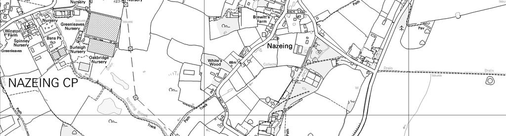
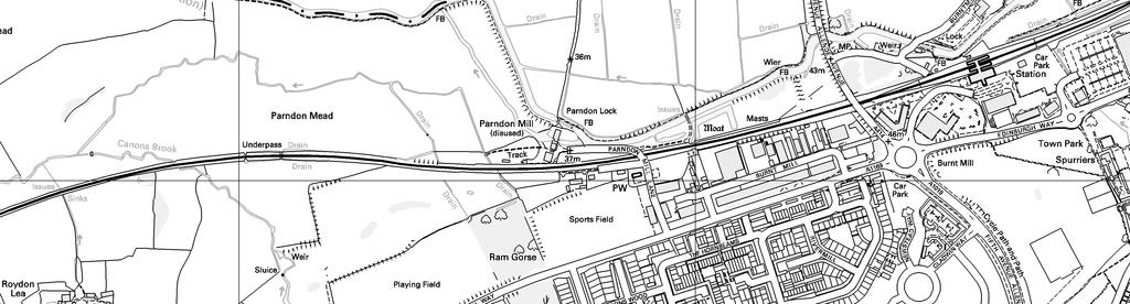
3 CHAPTER 2 ALLOTMENTS Site Number AT1 AT2 Site Name Roydon Village Allotments Broadley Common Allotment Address Area (Hectares) Harlow Road, Roydon 0.87 Common Road, Broadley Common Ownership Roydon Parish Council 1.05 Privately Owned ROYDON VILLAGE ALLOTMENTS (AT1) 2.0 Situated towards the centre of Roydon, vehicular access to this allotment is possible via a dirt track which runs southwards from Harlow Road to the north of the site. Pedestrian access to the allotment is also available to the east of the site where users can take the hard surfaced footpath which runs from Epping Road. This leads directly into Roydon playing fields (FP1) across which, to the east, sits the allotment itself. Directly to the north of the allotment is a gravel surfaced car park large enough for approximately 20 cars. This car park also serves the adjacent playing fields. 2.1 The perimeter of the site is made up of a combination of wooden fencing and medium sized hedgerows with one entrance available to the north. Access is also available elsewhere, particularly along the western perimeter through a number of gaps in the hedgerow. The northern entrance, located next to a litter bin, comprises a well signed large metal gateway which can be accessed directly from the car park. This metal gateway allows allotment users the option of parking their vehicles within the site should they wish to, although the vehicular path which runs between both entrances is not hard surfaced and there are no designated areas for vehicles to be parked. 2.2 To the west of the allotment one gap in particular is large enough to allow vehicular access into the site. Whilst this is strictly not permitted, the gap did enable access for the vehicles which were used to build the children s playground situated in the adjacent recreation ground. This main gap and all the smaller spaces in the hedgerow will all be secured through the purchase of wooden fencing which is likely to be installed in summer The allotment appears to be slightly underused, however this is a significant improvement on the previous when approximately only a quarter of the site currently in use. The last remainder of the allotment is left to semi-managed grassland and is cut once a year in line with wild flower practice and therefore very much adds to the overall visual appearance of the site. The allotment furthermore is clean, tidy and free of any litter. Page 3 of 27

4 Roydon Village Allotment, Site AT1 BROADLEY COMMON ALLOTMENT (AT2) 2.3 Located to the south east of the parish and accessible from Common Road, this is a very secluded site which is well hidden from the roadside. Inside however, the allotment is rather open in nature with the perimeter of hedgerows, which act as a screen from the roadside view to the west, decreasing in size thereby allowing for views out into the open countryside to the south and towards some of the homes of Broadley Common to the north. The perimeter of hedgerows dramatically increases in size as it reaches the east of the site where it is made up of a variety of fairly large trees and shrubs which screen the allotment from view to the east. 2.4 A single gated entrance is the only way into the allotment and this is located to the west of the site. This entrance is well screened from the road which makes detection of the site difficult and therefore there is no trouble with vandalism at the site. There is, however, the potential danger of site users getting in and out of the allotment as visibility on Common Road is severely restricted. 2.5 From the main entrance, a dirt track leads into the site until it reaches a number of sheds which are used in relation to the keeping of the plots on the allotment. The sheds are in a good condition, however it is not clear how frequently they are used. Only half of the site appears to be in use for allotments, with the remainder left as informal grass space. This space, in keeping with the rest of the site is well maintained and pleasant in appearance. Page 4 of 27
5 Broadley Common Allotment, Site AT2 ISSUES AND QUESTIONS Roydon Village Allotment (AT1) lacks a secure perimeter and entrance way. The entrance to Broadley Common Allotment (AT2) is particularly dangerous for site users to access and leave from and should therefore be made more visible from the roadside. Both sites appear to be clean, tidy and free from any obvious vandalism. There is a lack of any proper parking facilities on Broadley Common Allotment (AT2). A substantial number of plots have recently been allocated within the parish. Roydon Parish Council believes there to be sufficient levels of allotment provision in the parish currently given that roughly half the plots at Broadley Common are unused. There is no specific allotment provision for those with limited mobility however most parishes do not provide for this. Page 5 of 27
 3.")
6 CHAPTER 3 - CEMETERIES AND GRAVEYARDS Site Number Site Name Address Area (Hectares) CG1 St Peter s Church High Street, Roydon 0.52 CG2 Roydon United Reform Church Harlow Road 0.14 Ownership Diocese of Chelmsford Diocese of Brentwood St Peter s Church, Site CG1 ST PETER S CHURCH (CG1) 3.0 Comprising of a large church with adjoining church hall and set in L-shaped grounds which are very well kept, clean and free of any litter or vandalism, this is an attractive site which is located to the west of the High Street. Along the eastern boundary, the site is very open in nature whilst the remainder is screened by a perimeter of hedgerows and large trees which very much add to the overall visual amenity of the site. 3.1 Two main entrances into the churchyard are located to the south east corner of the site. The more southerly of the two entrances leads directly into a gravel surfaced car park, big enough for approximately 15 vehicles and situated adjacent to the south of the church hall building. Just to the north of this entrance, a second hard surfaced pathway leads directly into the built section between the church hall and church itself. An attractive wooden lynch Page 6 of 27

7 gateway is located on this pathway whilst just to the south of this between the two entrances is a wooden sign which is in good condition. 3.2 Moving west towards the back of the churchyard, the site is dominated by a variety of large trees. These overlook the site and place much of it in shade. To the west of this initial rectangular shaped site a wooden footbridge crosses over a small stream and leads into another rectangular section of burial grounds, again dominated by attractive trees and shrubbery. These two rectangular areas give the site its distinctive L-shape. 3.3 One issue to be raised with the site here regards its accessibility. That there are no hard surfaced footpaths leading beyond the main entrances into the church and church hall. Site users therefore have to walk across the grass to reach the westerly parts of the churchyard and this may be difficult for those members of the public who are less mobile. Wooden seating and some litter bins can be found throughout the site. The site is clean and tidy and has a pleasant setting. Roydon United Reformed Church, Site CG2 ROYDON UNITED REFORMED CHURCH (CG2) 3.4 Situated to the south of Harlow Road, this site is predominantly made up of an area of green burial space with a small modern church located in the north eastern corner. To the north western corner a hard surfaced track leads directly from Harlow Road along the western perimeter and into a hard Page 7 of 27
8 surfaced car park large enough for vehicles forming the south of the site. This car park is screened from external view by hedgerows and large trees to the west. Similarly the area of green burial space which makes up the vast majority of the site is also screened from view by further perimeter hedgerows. 3.5 Access to the church is possible via two hard surfaced paths, one from the south of the churchyard and one from the north western corner next to the roadside access for the car park. Both of these entrances are well gated whilst adequate signage can be found to the north of the churchyard facing the roadside. Whilst the sites small scale reduces the need for any seating or litter bins, it is nevertheless pleasing to the eye and is clearly maintained to a high level. ISSUES AND QUESTIONS Both sites are located within Roydon village to the north of the parish. Is there demand for a site of this type to the south of the parish, particularly within Broadley Common? The accessibility of St Peter s Church (CG1) could be improved by the provision of further hard surfaced paths beyond the main entrances to the church and church hall. Both sites are very well maintained. Both sites provide adequate amounts of seating, signage and litter bins. Both sites provide appropriate levels of well surfaced car parking. Page 8 of 27
 4.")
9 CHAPTER 4 FORMAL PLAYING PITCHES Site Number Site Name Address Area (Hectares) FP1 Roydon Playing Fields Epping Road, Roydon 3.62 Ownership Roydon Parish Council Roydon Playing Fields, Site FP1 ROYDON PLAYING FIELDS (FP1) 4.0 Situated at the centre of Roydon village towards the north of the parish, this site features a wide range of facilities including a seasonal cricket pitch and football pitches, two hard surfaced tennis courts and a children s playground. The site is accessible from two separate entrances. The first entrance is a small public footpath which leads into the site from Epping Road to the west of the playing fields. The second entrance is made up of a wider hard surfaced track which leads into the site from the point where Epping Road becomes Harlow Road to the north east of the playing fields. This hard surfaced track leads into a gravel surfaced car park large enough for approximately 20 vehicles. The car park is used by visitors to the playing fields and members of the public who own plots in the allotment gardens adjacent to the east. Page 9 of 27
10 4.1 With the exception of where the playing fields adjoin these allotment gardens, the sites perimeter is entirely made up of large shrubs and trees which help to create a strong inward and secluded feel. The playing fields are separated from the allotments by a smaller perimeter hedgerow that has a significant number of gaps in it and which therefore allows people to easily pass between the two sites. A small dilapidated wooden shed used to house football equipment can be found to the west of the playing fields close to the pedestrian entrance found here. This is highly unattractive and should either be renovated or removed. 4.2 Two hard surfaced tennis courts are located to the south west corner of the site, and these are in very good condition. Just to the east of the tennis courts is a children s playground (CY1) whilst adjacent to the south is a fenced off hard surfaced area suitable for a variety of sports including football and basketball. Both of these facilities are very new having only been built in summer Towards the centre of the playing fields is a clubhouse which is used by the local cricket team in the summer and the local football team in the winter. To the east of the clubhouse are cricket and football pitches which in conjunction with the rest of the site are very well maintained and in excellent condition. 4.3 Adequate seating, litter bins and dog waste bins are situated where necessary. However the signage at the entrance into the site to the north east is worn and only partially legible and is therefore in need of repair or replacement. The site lacks any hard surfaced footpaths making access harder for those less mobile members of the public, particularly during the colder, wetter times of the year. ISSUES AND QUESTIONS This is the only facility in the parish which offers formal playing pitches. A small proportion of the site is currently unused for any pitch sports and is instead readily available as an area of informal recreation. When not in use for pitch sports, the remainder of the site can also be used for informal recreation. A good range of other facilities can also be found on the site including tennis courts, hard surfaced court area and a children s playground (CY1). The small run down shed to the west of the Roydon Playing Fields (FP1) should either be renovated or removed as it detracts from the overall appearance of the playing fields. The lack any hard surfaced pathways is an issue for Roydon Playing Fields (FP1) given that it is likely to be visited by disabled persons. The perimeter hedgerow between Roydon Playing Fields (FP1) and Roydon Village Allotments (AT1) has a number of gaps within it allowing free access between the sites. Roydon Parish Council intend to introduce a new wooden fence perimeter between these sites this year in order to address this issue Page 10 of 27
11 The signage by the entrance to the north east corner of Roydon Playing Fields (FP1) is only partially legible and is therefore in need of repair or replacement. Roydon Parish Council has not indicated a current demand for provision of further sites of this type within the parish. Page 11 of 27
12 CHAPTER 5 ALTERNATIVE SITES FOR SPORT ISSUES AND QUESTIONS There are no sites within the parish which are specifically alternative sites for sport. A hard court area and two tennis courts however are available within Roydon Playing Fields (FP1) Given its very rural nature and small local population, Roydon Parish Council does not indicate a demand for the provision of any new alternative sites for sport within the parish. Residents wishing to use sites of this type of open space will need access to their own vehicles or public transport to travel to the neighbouring areas including Harlow and Hoddesdon, just across the district border, where such facilities are located. Page 12 of 27
13 CHAPTER 6 INFORMAL RECREATION GROUNDS Site Number RG1 Site Name Broadley Common Recreation Ground Address Common Road, Broadley Common Area (Hectares) 0.80 Ownership Roydon Parish Council Broadley Common Recreation Ground, Site RG1 BROADLEY COMMON RECREATION GROUND (RG1) 6.0 Situated adjacent to the south of Broadley Common Allotment (AT2), this recreation ground is made up entirely of grass land and unlike most other recreation grounds does not contain any formal facilities. Nether-the-less this is still an important piece of open space which is bordered on three sides by neat hedgerows and larger trees and shrubs along its northern perimeter. The site is accessible via a wooden gated entrance, including a wooden kissing gate, off Common Road to the west of the site. A small area of gravel in front of this gateway forms a makeshift car park large enough for a few cars. This car park is often used by users of the neighbouring allotment. The site appears to be very well maintained and is free of any visible litter or vandalism. Page 13 of 27
14 ISSUES AND QUESTIONS This is the only dedicated facility of its type within the parish. Roydon Playing Fields (FP1) does offer a small amount of informal recreation space, which increases when the formal playing fields are not in use. The site is clean, tidy, well maintained and free from any vandalism although it does not contain any facilities. Given its very rural nature and small local population, the Parish Council has not indicated a local demand for provision of further sites of this type within the parish. Page 14 of 27
 7.")
15 CHAPTER 7 CHILDREN S PLAYGROUNDS Site Number CY1 Site Name Roydon Playing Fields Playground Address Area (Hectares) Epping Road, Roydon 0.04 Ownership Roydon Parish Council ROYDON PLAYING FIELDS PLAYGROUND (CY1) 7.0 Situated to the west of the Roydon playing fields (FP1), this playground offers a good range of children s facilities which are all in good condition. The site is secured by a wooden perimeter fence with two metal gates to the west and east of the site allowing access for both maintenance vehicles and pedestrians respectively. One minor issue regards the site surfacing which is entirely made up of wood chippings. 7.1 Whilst wood chippings are preferable to grass, this type of surfacing does however make the playground more difficult to access for pushchair users and those who are less mobile. The site offers adequate amounts of seating and litter bins. However there is no signage located throughout the site whilst there is also evidence of significant amounts of graffiti on some of the children s facilities which will need to be removed. The lack of any hard surfaced footpaths leading up to the site may make access more difficult during colder, wetter times of the year, particularly for those people with pushchairs or who are less mobile. Roydon Playing Fields Playground, Site CY1 Page 15 of 27
16 ISSUES AND QUESTIONS This is the only playground located within the parish. The site is clean and tidy and offers a good range of children s facilities which are all well maintained. The site is secure and offers adequate provision of seating and litter bins. There are no signs located on the site whilst there is evidence of graffiti. The wood chip surfacing within the site potentially makes it less accessible to those with pushchairs or who are less mobile. The lack of any hard surfaced footpaths leading up to the site may make access more difficult during colder, wetter times of the year, particularly for those people with pushchairs or who are less mobile. Page 16 of 27
17 CHAPTER 8 - INDOOR FACILITIES FOR HIGH LEVELS OF USE ISSUES AND QUESTIONS There are no indoor facilities for high levels of use within Roydon. The Parish Council has indicated that there is no demand for a facility of this type within the parish given its rural nature and small local population. Such a facility would require large turnover in terms of use in order for it to be profitable and would not be sustainable if situated in such a rural location. Those residents wishing to access indoor facilities for high levels of use will need access to personal transportation or local public transport to reach neighbouring areas such as Harlow and Hoddesdon just across the district border where such facilities are provided. Page 17 of 27
18 CHAPTER 9 COMMUNITY CENTRES AND VILLAGE HALLS Site Number Site Name Address Area (Hectares) CV1 St Christopher s Hall Dobbs Weir Road 0.11 CV2 Roydon Village Hall Harlow Road, Roydon 0.10 CV3 St Peter s Church Hall High Street, Roydon 0.52 CV4 CV5 United Reform Church Hall Parma Room, (United Reform Church) Harlow Road, Roydon 0.05 Harlow Road, Roydon 0.14 Ownership Ownership Disputed Roydon Parish Council Diocese of Chelmsford United Reform Church United Reform Church ST CHRISTOPHER S HALL (CV1) 9.0 Situated along Dobb s Weir Road just to the east of its junction with Clyde Road, this hall was originally built by subscription in It was then used as a place of worship until 1964, when it was leased to the local resident s association. In 1979 it was reopened for monthly services and a Sunday school to serve the increasing local population. The hall has also been used by various groups for meetings and events as well as catering for various activity classes such as yoga. The site is in need of some fairly major refurbishment. The short term status of the hall however is uncertain as an ongoing dispute over the ownership of the site means that it may very well be closed in the not too distant future. ROYDON VILLAGE HALL (CV2) 9.1 Found just to the north of the junction between Harlow Road and Grange Lane, this hall is owned by the Roydon Parish Council and is extremely well used by the local residents. Activities which take place here include art classes, fitness classes, yoga sessions and a part time Doctors Surgery. The hall can also be hired out and is particularly busy over weekends when it is used for parties and various charity events. The local Parish Council are keen to point out that this is a very well used facility which is fully booked on a routine basis. The site is in very good condition therefore suggesting that it is maintained very well by those who use it. ST PETER S CHURCH HALL (CV3) 9.2 Situated along High Street opposite its junction with Duckett s Mead, this village hall is attached to St Peter s Church (CG1. The hall is used not only by church members but also by other external groups for a variety of different events including quiz nights, children s parties, mother and baby sessions, dancing clubs, singing clubs and needlework clubs. The hall is Page 18 of 27
19 also used in conjunction with the church for church festivals and music concerts. The hall is frequently used by the Parish Council and other groups for private and public meetings in addition to being the local polling station. UNITED REFORM CHURCH HALL (CV4) 9.3 Located along Harlow Road, directly opposite its junction with Beaumont Park Drive, this site comprises of a small hall with a small cottage attached to it. Currently in the ownership of the United Reform Church, this site has been closed in recent times and has recently been designated as unsafe to use following a structural survey. Before its closure, the site was used as a base for the local Brownie and Cubs groups and was also used for children s birthday parties. The United Reform Church hope to sell both the hall and the adjoining cottage in the coming months as the costs of rebuilding the hall are too great. PARMA ROOM (UNITED REFROM CHURCH (CV5) 9.4 Adjoined to the United Reform Church (CG2), this suite is predominantly used by the church itself however it does also welcome some local groups including the local knitting club, and can also be let out for various events such as meetings, and coffee mornings. The site is part of an extension, added to the church within the last 5 years and is therefore still in very good condition. ISSUES AND QUESTIONS The future of the United Reform Church Hall (CV4) appears uncertain given that it is shortly to be sold. The future of St Christopher s Hall (CV1) is also uncertain as the site is currently at the centre of an ownership dispute between the local residents association and the church. It also needs major refurbishment works. Despite these potential losses, there appears to still be a good level of provision of this type of facility within the parish. The Parish Council are keeping the position of whether there is a need for further provision of this type of facility under review. Those remaining facilities in the parish with clear future are all in good condition and are well maintained by those who use them. Page 19 of 27

20 CHAPTER 10 MANAGED OPEN SPACE WITH PUBLIC ACCESS Site Number MO1 MO2 Site Name Land surrounded by Parkfields Land to the north west of Parkfields Address Area (Hectares) Parkfields, Roydon 0.13 Parkfields, Roydon 0.12 MO3 The Green High Street, Roydon 0.16 MO4 MO5 Land to the north of Little Brook Road Roydon Community Orchard Little Brook Road 0.27 Harlow Road, Roydon 0.20 Ownership Epping Forest District Council Epping Forest District Council Roydon Parish Council Epping Forest District Council Roydon Parish Council Land Surrounded by Parkfields, Site MO1 LAND SURROUNDED BY PARKFIELDS (MO1) 10.0 Comprising two areas of well maintained grassland, separated from each other and surrounded by Parkfields, this amenity green space very much contributes to the overall scene of the local residential area in which it sits. A single medium sized tree is located to the north of each section of the site and these very much add to the overall visual amenity. At the time of this Audit a number of rubber kerbstones had been left on the site, including by the base of the southern most tree. These will need to be removed as they detract from the overall appearance of the site. Whilst this site is larger than most amenity Page 20 of 27
 10.")
21 green spaces found in residential areas, it is nonetheless still surrounded by roads and this therefore makes it unsuitable for anything more than dog walking or as a local visual amenity. Land to the North West of Parkfields, Site MO2 LAND TO THE NORTH WEST OF PARKFIELDS (MO2) 10.1 Found along the eastern verge of Parkfields as it travels north-west towards Hansells Mead, this is an attractive area of amenity green space which is clean, tidy and obviously well maintained. To the west of the site, three hard surfaced areas provide off road car parking for approximately 12 vehicles. Running across the centre of the site are four large flower beds which when in season very much contribute to the attractiveness of the local residential area. To the west, runs a residential pathway which then cuts across the site in two places dividing it into three separate sections. Given the small size of the site, it is again unsuitable for any use other than as a visual amenity and perhaps dog walking. This fact is emphasised by the presence of a sign which decrees that no ball games are allowed to be played on the site. Page 21 of 27

22 The Green, Site MO3 THE GREEN (MO3) 10.2 Situated to the north of Roydon village, close to the parish and district border with neighbouring Hertfordshire, this site is an area of amenity green space which comprises almost entirely of flowering grassland. Along the western border of the site runs High Street whilst the remaining two sides are bordered by hard surfaced paths along which residents drive and park their cars. A large white war memorial can be found to the south of the site as well as a single black litter bin whilst a further black bin is located to the north. Towards the eastern perimeter of the site lie a couple of wooden benches whilst close to the opposite perimeter are the village s coat of arms. The entire site is surrounded by a perimeter of low level wooden fencing which provides large enough gaps between each section to allow access for pedestrians whilst ensuring that vehicles do not park on the green One small issue with the site regards the signage located to the north which appears a little worn and is in need of repairing or replacing. Whilst the signage advocates no dog fouling, there are no dog waste bins located within or around the site. Overall this is an attractive site which appears to be well maintained and is clean, tidy and free of any litter or noticeable vandalism. Whilst the site is of reasonable size, given its location next to a relatively busy road, it is only suitable for informal recreation and as a local visual amenity. Page 22 of 27

23 LAND TO THE NORTH OF LITTLE BROOK ROAD (MO4) 10.4 Located to the south west of the junction between Harlow Road and Little Brook Road, this is an area of amenity green space which is made up of grassland to the south and west and woodland to the north and east. To the north the site borders Harlow Road whilst the western and southern perimeters are defined by Little Brook Road. The eastern perimeter to the site, beyond its wooded area, adjoins Roydon United Reformed Church (CG2). The site appears to be well looked after and is clean and litter free. A hard surfaced footpath runs through it providing access between Little Brook Road and Harlow Road. This site is suitable only for use as a local visual amenity given its small size and the fact that it faces roads on three sides. Land to the north of Little Brook Road, Site MO4 ROYDON COMMUNITY ORCHARD (MO5) 10.5 Situated to the south of Roydon Village Allotment (AT1), this site is a small rectangular shaped area of grassland which has a number of apple trees planted within it. The site is largely screened from view by a perimeter of medium sized trees and shrubs although the northern perimeter of the site opens directly into the neighbouring allotment. The site appears to be well maintained and is clean and tidy and shows no sign of any vandalism or litter. Page 23 of 27
24 Roydon Community Orchard, Site MO5 ISSUES AND QUESTIONS The vast number of sites are too small for them to be used for anything more than as a local visual amenity. Sites such as The Land to the North West of Parkfields (MO2) are therefore signed to ensure that they are not used by children for playing activities such as ball games. All of the sites are well maintained and were generally clean and tidy at the time of auditing with the exception of the Land Surrounded by Parkfields (MO1). Those sites which are large enough to warrant having litter bins and seating located on them do so, and these appear to be in good condition. Page 24 of 27
25 CHAPTER 11- WOODLAND AND SEMI-NATURAL OPEN SPACE WITH PUBLIC ACCESS Site Number Site Name Address Area (Hectares) SO1 Nazeing Meads Meadgate Road, Roydon SO2 SO3 Hunsdon Mead Roydon Mead On canal path from rail station, Roydon On canal path from rail station, Roydon SO4 Glen Faba Glen Faba Road SO5 Dobbs Weir Dobb s Weir Road, 5.02 Ownership Lee Valley Regional Park Hertfordshire, Middlesex and Essex Wildlife Trusts Hertfordshire, Middlesex and Essex Wildlife Trusts Lee Valley Regional Park Lee Valley Regional Park NAZEING MEADS (SO1) 11.0 This site is predominantly located in Nazeing Parish apart from a relatively small section to the north which enters into the south western corner of Roydon Parish. Nazeing Meads is made up of three large lagoons, wildflower meadows and a section of the Regional Park Pathway which runs through it. The pathway heads from Nazeing Road to Meadgate Road and will be extended within the next few years to join Clayton Hill from the south and the River Lee Navigation from the north Popular with visitors for informal recreation, the site connects with a variety of other areas of the Lee Valley Park and offers a circular route around the lakes with mowed grass paths suitable for both walking and cycling. The lagoons themselves are well used by a variety of sailing and fishing clubs. The southern end of the site was once an airfield and was then turned into gravel pits. Along with the rest of the site it was subsequently used for landfill. Today, much of the site is grazed upon by cattle in order to encourage the wildflowers that now grow there. The three lagoons meanwhile, which were formerly gravel pits, are open to fishing. HUNSDON MEAD (SO2) 11.2 Situated to the north east of Roydon Village and accessible via a canal path from Roydon station, this SSSI designated site is an area of common land between the River Stort and the Stort Navigation the border between Essex and Hertfordshire. The site was bought by Hertfordshire, Middlesex and Essex Wildlife Trusts in 1981 and is today regarded as one of the finest areas of unimproved grassland in the region. Hunsdon Mead provides a superb array of flowering plants from April through to July and harbours a number of rare plants and flying insects. During the winter, the Mead floods, and is then Page 25 of 27
26 used by large numbers of migrating birds. Managed in the same way for an estimated 600 years (under the Lammas system), grazing is only allowed to take place on the site between 1 st August to 1 st March, after which vegetation is allowed to grow back up again until the following year. ROYDON MEAD (SO3) 11.3 Situated to the north eastern corner of the parish, south east of Hunsdon Mead and separated by the Stort navigation, this site is partially designated as a SSSI and, similarly to Hunsdon Mead is a registered Common. Like Hunsdon Mead, the site is one of the last remaining areas in the region to still be managed under the Lammas system of hay making followed by winter grazing. Together with Hunsdon Mead, the site forms a large area of unimproved grassland on alluvial soils subject to occasional winter flooding. The site contains a variety of rare plants and flowers as well as a number of flying invertebrates which cannot be found anywhere else in the region. GLEN FABA (SO4) 11.4 Situated to the west of the parish and accessible from Dobbs Weir Road, this site consists of two man-made lakes which were formed as a result of sand and gravel extractio. Glen Faba is the largest lake, and was formerly a mature 120 acre gravel pit. The smaller lake, to the north west of this is known as Stort Pit. Within Glen Faba Lake lie three wooded islands. These were formed either as a result of a break in the gravel seam with excavation discontinuing or as the location of reject piles. These were piles of large stone material with silt and mud that were of no use to the local industry and were left in piles on the site Today, Glen Faba forms the perfect setting for peaceful walks overlooking the lakes. Glen Faba Lake is open as a permit only fishery. The site is also an excellent place to view birds during the winter. A range of birds chose to roost on the three islands in the lake. Whilst access for persons with disabilities is possible, it is really dependant on the confidence of each individual and any help that may be on hand for assistance. Cycle access to the site is possible using the towpaths. However the managers of Glen Faba Lee Valley Regional Park currently suggest that the site is not suitable for cycling. The only parking available is in the Dobb s Weir Café Car Park or in the Fish and Eel pub, both of which are limited. A public toilet suitable for those with disabilities however can be found opposite the car park to the Fish and Eels pub. Page 26 of 27
27 DOBBS WEIR (SO5) 11.6 Situated in the south western corner of the parish, this site is a collection of highly attractive open green space areas which are situated adjacent to the River Lee Navigation and are predominantly used for informal recreation. Dobbs Weir is used for fishing whilst it is also a good place to start and end walks given its good access into a number of neighbouring sites including Nazeing Meads/Carthagena, Admirals Walk Lake and Glen Faba which are all nearby. Boat and barge moorings are available on the River Lee Navigation near to the café whilst on the weir pool site exists one of the countries oldest manual weirs. This was formerly used to control water levels in the Navigation. 11.7The site generally has good access with hard surfaced paths in all areas except the Island Site. This area is located near the car park opposite the Fish and Eel Pub on the opposite bank to the River Lee Navigation. Car parking meanwhile is fairly restricted with only Dobb s Weir Café car park and the Fish and Eels pub again offering any form of car parking. A toilet block with disabled facilities can be found opposite the car park to the Fish and Eels pub. ISSUES AND QUESTIONS All of the sites in this category in the parish are managed and maintained to an excellent level by Lee Valley Regional Park Authority and Essex Wildlife Trust. All of the sites are excellent areas of open space ideally suited for informal recreation. Efforts continue to further improve accessibility and safety for children. One issue regarding the use of these sites appears to be the lack of car parking particularly with regards to Glen Faba (SO4) and Dobbs Weir (SO5). These sites all provide good opportunities for visitors to access some of the district s most important and attractive areas of open space. These areas of open space also provide important habitats for local species of flora and fauna. Page 27 of 27


 Woodland and")


 Indoor")
")


28 PPG17 - Roydon SO2 SO3 CV3 MO3 CV5 CG1 CV2 CG2 MO4 CV4 CY1 AT1 MO5 MO2 MO1 SO4 FP1 SO5 CV1 SO1 AT2 RG1 Key Parish: Roydon Area: 1091 Hectares Informal Recreation Grounds (RG) Woodland and Semi-Natural Open Space with Public Access (SO) Cemeteries and Graveyards (CG) Children's Playgrounds (CY) Managed Open Space with Public Access (MO) Formal Playing Pitches (FP) Indoor Facilities For High Levels Of Use (IF1) Epping Forest Alternative Sites For Sport (AS) Community Centres and Village Halls (CV) Scale: A0 Allotments (AT) No Window The material contained in this plot has been reproduced from an Ordnance Survey map with the permission of the Controller of Her Majesty's Stationery. (c) Crown Copyright. Unauthorised reproduction infringes Crown Copyright and may lead to prosecution or civil proceedings. EFDC licence No County Series Maps (c) Crown Copyright Landmark Information Group Ltd NG British Geological Survey data - (c) Copyright Natural Research Council 2001/91 IPR/16-26DX Cities Revealed (R) Copyright Geoinformation Group 1932 Parish Boundary * Denotes Membership Only Facilities Date: 4th January 2010
MORETON, BOBBINGWORTH AND THE LAVERS OPEN SPACE AUDIT JULY Chapter 1 Introduction Page 2. Chapter 2 Allotments Page 3
 MORETON, BOBBINGWORTH AND THE LAVERS OPEN SPACE AUDIT JULY 2009 CONTENTS Chapter 1 Introduction Page 2 Chapter 2 Allotments Page 3 Chapter 3 Cemeteries And Graveyards Page 5 Chapter 4 Formal Playing Pitches
GREENFORD HALL & ADJOINING LAND
 GREENFORD HALL & ADJOINING LAND CONTENTS 1. Introduction 1. Introduction 2. Urban Context 2.1 The Site and Surroundings 2.2 Urban Context Map 2.3 Access and Movement 3. Planning Context 3.1 Planning History
Former Panshanger Aerodrome, Welwyn Garden City Masterplan Scenarios. Mariposa Investments
 Former Panshanger Aerodrome, Welwyn Garden City Masterplan Scenarios Mariposa Investments Contents 1.0 Introduction 1 2.0 The Site and Surroundings 2 3.0 Local Area Context 6 4.0 Site Features 10 5.0 Development
Landscape and Heritage A Park landscape that embraces the physical, cultural and social heritage of the area
 80 Park Development Framework Our Aim for Landscape and Heritage A Park landscape that embraces the physical, cultural and social heritage of the area Why do we think it is important? The landscapes of
Landscape and Heritage
 86 Park Development Framework Our Aim for A Park landscape that embraces the physical, cultural and social heritage of the area Why do we think it is important? The landscape provides a setting for every
Site ref: AS06 Site Name or Address: Murreys Court, Agates Lane
 Site ref: AS06 Site Name or Address: Murreys Court, Agates Lane Proposed Land Use: Total Site Area (Ha): Housing 1.85 Ha Description: It is understood that the owner has no plans to dispose of the site
GREENSPACES MANAGEMENT
 GREENSPACES MANAGEMENT 3-year Strategy Routine Management & Improvement Plan covering the 25 sites owned and/or managed by Stroud Town Council. A three-year plan to run from financial year - 2013/14 THE
Neighbourhood Planning Local Green Spaces
 Neighbourhood Planning Local Green Spaces Introduction... 2 1. Why green space is important... 4 2. Neighbourhood plans and green space... 6 3. Evidence... 8 Statutory designations... 9 Green space audit...
YMCA Erdington (Phase 2), 300 Reservoir Road, Erdington, Birmingham, B23 6DB
, 300 Reservoir Road, Erdington, Birmingham, B23 6DB") Committee Date: 13/06/2013 Application Number: 2013/03011/PA Accepted: 30/04/2013 Application Type: Full Planning Target Date: 30/07/2013 Ward: Stockland Green YMCA Erdington (Phase 2), 300 Reservoir Road,
Committee Date: 13/06/2013 Application Number: 2013/03011/PA Accepted: 30/04/2013 Application Type: Full Planning Target Date: 30/07/2013 Ward: Stockland Green YMCA Erdington (Phase 2), 300 Reservoir Road,
WELCOME TO THE NEW WILTON PARK
 WELCOME TO THE NEW WILTON PARK VISION HISTORY OF WILTON PARK TOWARDS A PLANNING APPLICATION Our objective is to create a truly outstanding environment at Wilton Park. At the heart of our proposals is a
Toddington Central Bedfordshire Stage 3 Green Belt Study December 2017
 Toddington Central Bedfordshire Stage 3 Green Belt Study December 2017 Site: ALP086 - Middle Lakes, Toddington Site size (ha): 2.83 Site: ALP086 - Middle Lakes, Toddington Site size (ha): 2.83 Site description
Welcome to our exhibition
 Welcome to our exhibition The Homes & Communities Agency (HCA) welcomes you to this public exhibition explaining our proposals for the redevelopment of the former Lea Castle Hospital site. About the Homes
Neighbourhood Planning Guidance Local Green Spaces
 Neighbourhood Planning Guidance Local Green Spaces Introduction This guidance note has been produced for communities preparing neighbourhood plans in North Dorset to help them to identify, assess and designate
Ashtead Neighbourhood Forum Site Assessment AS07 Old Chalk Pit, Pleasure Pit Road. Site ref: AS07 Site address: Old Chalk Pit, Pleasure Pit Road
 Site ref: AS07 Site address: Old Chalk Pit, Pleasure Pit Road Proposed Land Use: Total Site Area (Ha): Housing 0.7ha Description: The site was formally an old chalk pit that has been partially filled and
LOGGERHEADS NEIGHBOURHOOD PLAN LOCAL GREEN SPACE DESIGNATION OCTOBER 2016
 DRAFT LOGGERHEADS NEIGHBOURHOOD PLAN LOCAL GREEN SPACE DESIGNATION OCTOBER 2016 1. Introduction For many local communities, green infrastructure in and around their neighbourhood is an important issue,
Local Green Space. Site: Land surrounding All Saints Church and the recreation grounds, Earls Barton Site Appraisal: 02/12/13 Site Code: LGS1
 Local Green Space Site: Land surrounding All Saints Church and the recreation grounds, Earls Barton Site Appraisal: 02/12/13 Site Code: LGS1 Original Source es o Existing Local Plan Designation Suggested
Environmental and Landscape Mapping
 Environmental and Landscape Mapping In support of the Calveley Neighbourhood Plan November 2016 Project Name and Number: Calveley Neighbourhood Plan 16-025 Document Name and Revision: Environmental and
SPG 1. * the northern and western sections which are open fields used for pasture and grazing;
 SPG 1 1.0 INTRODUCTION This development brief is based on the allocation of the Priors Hall site for employment and countryside recreational purposes in the Corby Borough Local Plan. The brief is intended
The analysis of key visual characteristics and attributes that contribute to variations in the
 15.0 CHIGWELL/CHIGWELL ROW 15.1 Overview 15.1.1 Chigwell and Chigwell Row settlements are situated in the south of Epping Forest District, to the south of Abridge and southwest of Stapleford Abbotts. Both
Welford-on-Avon. Neighbourhood Development Plan Welford-on-Avon Parish Council
 Welford-on-Avon Neighbourhood Development Plan 2011-2031 Welford-on-Avon Parish Council Parish Consultation: Summary Version December 2014 January 2015 Foreword This is the latest version of the Welford
Rudy Parish Neighbourhood Plan Steering Group Meeting 6/8/2018. Proposed Green Spaces (Continued from SG meeting of 2/7/18)
") Rudy Parish Neighbourhood Plan Steering Group Meeting 6/8/2018 Proposed Green Spaces (Continued from SG meeting of 2/7/18) NPPF: Green Space Designation The Local Green Space designation will not be appropriate
Rudy Parish Neighbourhood Plan Steering Group Meeting 6/8/2018 Proposed Green Spaces (Continued from SG meeting of 2/7/18) NPPF: Green Space Designation The Local Green Space designation will not be appropriate
WELCOME. Land North of STEVENAGE. We would like to thank you for attending our public exhibition today.
 WELCOME We would like to thank you for attending our public exhibition today. The purpose of this event is to share our proposals and hear your thoughts on our ideas. Members of the project team are on
ENVIRONMENTAL AND LANDSCAPE MAPPING
 APPENDIX IV : Environmental and Landscape Mapping ENVIRONMENTAL AND LANDSCAPE MAPPING Calveley Neighbourhood Plan November 2016 ENVIRONMENTAL AND LANDSCAPE MAPPING Calveley Neighbourhood Plan Calveley
Welcome to our public exhibition
 About our development Welcome to our public exhibition This exhibition gives you the chance to view and comment on our proposals for a new residential development of 165 high-quality homes, along with
St Michaels C of E Junior & Infant School, Nantmel Grove, Bartley Green, Birmingham, B32 3JS
 Committee Date: 06/03/2014 Application Number: 2013/08595/PA Accepted: 19/11/2013 Application Type: Full Planning Target Date: 14/01/2014 Ward: Bartley Green St Michaels C of E Junior & Infant School,
Public Consultation. Land at Monks Farm, North Grove. Welcome
 Welcome Welcome to our public exhibition for development on Land at Monks Farm, orth Grove. Gallagher Estates and Gleeson Strategic Land are preparing an outline planning application for new homes, open
edge of gas line corridor setback edge of gas line corridor aligned with Schlumberger building 37.0 m AOD 33.0 m AOD max
 7. Heights and Street Frontage: In accordance with the approved heights parameters, heights to along Western Access Road must respond to the existing low density character in this location. Heights are
Gilly Vean Farm. South Cornwall
 Gilly Vean Farm South Cornwall Gilly Vean Farm GWENNAP, SOUTH CORNWALL, TR16 6BN Farmhouse set centrally within extensive grounds with equestrian facilities, countryside views and potential for holiday
Welcome to Church Road Hanworth Allotments. This pack should give you all the information you need to get your way around owning an allotment.
 WELCOME PACK 1. Introduction 2. Plot Guidelines 3. Association Committee members 4. Plan of site 5. Facilities and costs 6. Chickens 7. Bee Keeping 8. Adrian Hall discount card form 9. Application to join
About 10% of the Borough's population lives in the seven rural parishes. Population figures from the 1991 census are given below:-
 8. THE DISTRICT VILLAGES 8.1 Population About 10% of the Borough's population lives in the seven rural parishes. Population figures from the 1991 census are given below:- Village No. of Persons Cottingham
Exploring Abergavenny
 11 Majors Barn36 Ysguborwen Exploring Abergavenny 2 ysguborwen EXPLORING ABERGAVENNY For several years the Abergavenny and District Civic Society has been studying the streets, spaces and buildings of
White Ladies Hazeley Bottom, Hampshire
 White Ladies Hazeley Bottom, Hampshire White Ladies Hazeley Bottom, Hampshire RG27 8LU A delightful period house well-positioned in a rural hamlet with mature gardens and paddocks Hartley Wintney 1 mile,
Lancaster Conservation Area Appraisal. Character Area 8. Cathedral
 Lancaster Conservation Area Appraisal Character Area 8. Cathedral March 2013 118 3.8 Character Area 8. Cathedral 3.8.1. Definition of Special Interest "This character area is distinctive for the fine group
POTTERSPURY PARISH COUNCIL Grass Mowing and Tree & Shrub Maintenance Tender 2017
 SPECIFICATION 1. GENERAL MOWING: To mow to the satisfaction of the Parish Council the areas marked on the maps being: 1.1. Verges throughout the village including the vision splays in front of all four
Introduction. Welcome to this consultation regarding the draft redevelopment proposals for the former CeramTec factory on Sidmouth Road, Colyton.
 Introduction Welcome to this consultation regarding the draft redevelopment proposals for the former CeramTec factory on Sidmouth Road, Colyton. We are currently considering options for the mixed-use redevelopment
CHIPTON FARMHOUSE CHIPTON BARTON DITTISHAM NR DARTMOUTH DEVON
 CHIPTON FARMHOUSE CHIPTON BARTON DITTISHAM NR DARTMOUTH DEVON CHIPTON FARMHOUSE CHIPTON BARTON, DITTISHAM, NR DARTMOUTH. TQ6 0HW A beautiful farmhouse with adjoining annexe, two guest cottages, a wonderful
Site ref: AS05 Site address: Ashtead Park Garden Centre, Pleasure Pit Road
 Site ref: AS05 Site address: Ashtead Park Garden Centre, Pleasure Pit Road Proposed Land Use: Total Site Area (Ha): Housing 1.25ha Description: The site is located off Pleasure Pit Road near the junction
ENVIRONMENTAL INVENTORY
 Hungarton Neighbourhood Plan ENVIRONMENTAL INVENTORY Sites scoring 25/36 or more (70%) are judged to be the most important environmental and community sites and are proposed as Local Green Space. Other
Ashtead Neighbourhood Forum Site Assessment AS14 Land at The Pines, Farm Lane. Site ref: AS14 Site address: Land at The Pines, Farm Lane
 Site ref: AS14 Site address: Land at The Pines, Farm Lane Proposed Land Use: Total Site Area (Ha): Housing 2.1ha Description: The site is located to the east of Ashtead off Farm Lane and is currently grassed.
Land at Rampton Road. Cottenham
 Land at Rampton Road Cottenham Introduction TEP is preparing an outline planning application for 54 dwellings on 6.9 hectares of land adjacent to Rampton Road, Cottenham on behalf of the owners Cambridgeshire
PCAL Case Study Open Spaces: Blayney Heritage Park
 PCAL Case Study Open Spaces: Blayney Heritage Park Introduction Blayney Heritage Park is an area of high quality open space that offers a range of active and passive recreation facilities. The multi-purpose
White Ladies Hazeley Bottom, Hampshire
 White Ladies Hazeley Bottom, Hampshire White Ladies Hazeley Bottom, Hampshire, RG27 8LU A delightful period house well-positioned in a rural hamlet with mature gardens and paddocks. Hartley Wintney 1 mile,
ALLERTHORPE NEIGHBOURHOOD PLAN
 Allerthorpe s Neighbourhood Plan sets out a vision for the Parish for the next 15 years (2018 2033) that builds on and reflects the opinions and views of parish residents. VISION In 2033 Allerthorpe will
Olympics. Large areas of the Lower Lea Valley have now been taken for the Olympics and surrounded by tall blue fences.
 Olympics December 2007 Update. Large areas of the Lower Lea Valley have now been taken for the Olympics and surrounded by tall blue fences. White Hart Field and small pockets of open space along Waterden
Settlement Boundaries Methodology North Northumberland Coast Neighbourhood Plan (August 2016)
") Introduction This background paper sets out a methodology for the definition of settlement boundaries in the North Northumberland Coast Neighbourhood Plan. The neighbourhood plan is planning positively
Introduction This background paper sets out a methodology for the definition of settlement boundaries in the North Northumberland Coast Neighbourhood Plan. The neighbourhood plan is planning positively
Welcome to our public exhibition
 About our scheme Welcome to our public exhibition Taylor Wimpey East Anglia intends to submit a detailed planning application for a new residential development of 39 high-quality homes at the B&M Concrete
Exton Lodge 8PP.qxp_Stags 06/06/ :38 Page 1 EXTON LODGE D E V O N
 EXTON LODGE DEVON Exton Lodge 8PP.qxp_Stags 06/06/2017 11:38 Page 2 Exton Lodge Mill Lane, Exton, Exeter, Devon EX3 0PJ Topsham 2.5 miles Exmouth 4 miles Exeter 7 miles A substantial and elegant detached
LAND SOUTH OF ROUNDABOUT AT END OF PRIORY CHASE, RAYLEIGH, ESSEX PROVISION OF A SCOUT BUILDING, ACCESS AND CAR PARKING
 16/00123/FUL LAND SOUTH OF ROUNDABOUT AT END OF PRIORY CHASE, RAYLEIGH, ESSEX PROVISION OF A SCOUT BUILDING, ACCESS AND CAR PARKING APPLICANT: ZONING: PARISH: WARD: MR ANDREW AUSTIN EXISTING RESIDENTIAL
HUNGERFORD SOLAR FARM
 HUNGERFORD SOLAR FARM Key Facts The site comprises approximately 26 acres/10.6 hectares of Grade 3 and 4 agricultural land, currently in arable use. It will have a generation capacity of approximately
STRENSALL RAILWAY BUILDINGS CONSERVATION AREA APPRAISAL. In association with Strensall with Towthorpe Parish Council
 STRENSALL RAILWAY BUILDINGS CONSERVATION AREA APPRAISAL In association with Strensall with Towthorpe Parish Council CONTENTS Page 1 Introduction 2 2 Location and Context 3 3 Topography and Setting 4 4
Former North Works, Lickey Road, Longbridge, Birmingham
 Committee Date: 14/11/2013 Application Number: 2013/06431/PA Accepted: 27/08/2013 Application Type: Full Planning Target Date: 26/11/2013 Ward: Longbridge Former North Works, Lickey Road, Longbridge, Birmingham
Contents. Appendices. Open Spaces Summary Report: Wilmslow
 Contents 1 Socio-Economic Profile Type 1: Parks & Gardens Type 2: Natural & Semi-Natural Urban Greenspaces Type 3: Green Corridors Type 4: Outdoor Sports Facilities Type 5: Amenity Greenspace Type 6: Provision
New House Farm, Risbury, Nr Leominster, Herefordshire
 New House Farm, Risbury, Nr Leominster, Herefordshire A beautiful farmhouse and numerous extremely versatile outbuildings, in extensive gardens and paddocks with superb views. 7 Acres LOCATION Leominster
Cranes Farm, Epwell, Oxfordshire
 Cranes Farm, Epwell, Oxfordshire Cranes Farm, Epwell Oxfordshire, OX15 6LH A delightful Oxfordshire farmhouse on the edge of this sought after village with fabulous views over its own land and the surrounding
Land to West of Bessel s Way, Blewbury. Contextual Analysis. fluid
 Land to West of Bessel s Way, Blewbury Contextual Analysis fluid Contents fluid - Overview - Growth pattern - Footpath & Road connections - Landscape Character - Amenities - Agriculture - Characteristic
Welcome to our public exhibition
 About Our Scheme Welcome to our public exhibition This exhibition gives you the chance to view and comment upon our emerging proposals for a new residential development of 68 new homes on the site of the
Environment Agency Flood Risk Map for the Village of Bridge
 Environment Agency Flood Risk Map for the Village of Bridge December 2016 21 Objective F. Conserving and Enhancing the Natural Environment The National Planning Policy Framework states that the planning
The Miller s House. Rode Hill, Rode, Somerset, BA11 6PS
 The Miller s House Rode Hill, Rode, Somerset, BA11 6PS The Miller s House Rode Hill, Rode, Somerset, BA11 6PS A beautiful Grade II* listed Queen Anne former dye house set in over 2 acres Entrance Hall,
Hardy s Cottage Access Statement
 Hardy s Cottage Access Statement Hardy s Cottage Higher Bockhampton Dorchester Dorset DT2 8QJ T: 01305 262366 E: hardyscottage@nationaltrust.org.uk Introduction 1. The cottage is situated 700 yards from
Maesgwynne Hall Estate. Howey Nr Llandrindod Wells Powys
 Maesgwynne Hall Estate Howey Nr Llandrindod Wells Powys Maesgwynne Hall Estate Howey Nr Llandrindod Wells Powys ld1 5rn Exciting Sporting Estate in Mid Wales Exciting opportunity to acquire an historic
How important is it to use our Neighbourhood Plan to try to find ways of improving the natural environment of the Parish?
 Question 15 Landscape and nature: How important is it to use our Neighbourhood Plan to try to find ways of improving the natural environment of the Parish? If you think it s important, where in the parish
NORTH WEST LEEDS COUNTRY PARK AND GREEN GATEWAYS PROJECT. Country Parks Officer Douglas Louis
 NORTH WEST LEEDS COUNTRY PARK AND GREEN GATEWAYS PROJECT Country Parks Officer Douglas Louis Vision To Preserve, Improve and Promote Green Spaces and their Connectivity for People & Wildlife in North West
Park Development Framework Area Proposals. Context to Area 2 Ruckholt Road to Coppermill Lane
 Park Development Framework Area Proposals Context to Area 2 Ruckholt Road to Coppermill Lane The defining feature of this area is the broad expanse of marshlands. These provide the context for a diverse
1.0 INTRODUCTION. Brantham Industrial Area Regeneration - Factory Lane - Brantham
 1.0 INTRODUCTION Welcome to this exhibition of our proposals for the regeneration of the Brantham Industrial Area located off Factory Lane in Brantham. This presentation will give you an opportunity to
The Cedars THE CAUSEWAY 8 GREAT HORKESLEY 8 COLCHESTER
 The Cedars THE CAUSEWAY 8 GREAT HORKESLEY 8 COLCHESTER The Cedars The Causeway, Great Horkesley, Colchester CLASSIC PERIOD COUNTRY HOUSE WITH SELF CONTAINED ANNEXE, SUPERB GARDENS & PADDOCKS ON THE EDGE
Ringsend & Irishtown Local Environmental Improvement Plan
 Ringsend & Irishtown Local Environmental Improvement Plan Study Area East Link Bridge St. Patrick s Boat Club Ringsend Technical Institute Stella Maris Boat Club St. Patrick s Church Ringsend Library Ringsend
7.1 Area 1: Haslemere Conservation Area
 7.1 Area 1: Haslemere Conservation Area Detailed map of Haslemere Town Conservation Area as of 2006 Crown copyright and database right 2011 Ordnance Survey LA100025451 27 The Conservation Area is characterised
Long Crendon Neighbourhood Plan Local Green Space and Landscape Study Report September 2016
 Long Crendon Neighbourhood Plan Local Green Space and Landscape Study Report September 2016 1 Long Crendon Neighbourhood Plan Local Green Space and Landscape Study Report This report has been prepared
Alder View. Introduction. Alder View. Harwell. The Vision. The Team. Taylor Wimpey
 Introduction Welcome to the public exhibition for, a development by Taylor Wimpey on the land south of Grove Road,. This exhibition will provide an overview of the development proposals for the site and
U p p e r L a n g d a l e s F a r m h o u s e C R E E T I N G S T M A R Y 8 S U F F O L K
 U p p e r L a n g d a l e s F a r m h o u s e C R E E T I N G S T M A R Y 8 S U F F O L K Upper Langdales Farmhouse Creeting St Mary, Suffolk, IP6 8QF R E S T O R E D P E R I O D F A R M H O U S E I N
ROSKRUGE BARTON COTTAGE MANACCAN, THE LIZARD
 ROSKRUGE BARTON COTTAGE MANACCAN, THE LIZARD ROSKRUGE BARTON COTTAGE MANACCAN, THE LIZARD, TR12 6EN A charming cottage in an idyllic rural location. Manaccan: 1 Gillan Cove: 2.1 Helford Village: 2 Helston:
ANCHORAGE PARK REPORT CARD Assessing A Park s Appearance, Function, & Condition
 ANCHORAGE PARK REPORT CARD Assessing A Park s Appearance, Function, & Condition Park Name: Is Your Park an A or an F? Your Name: Contact Information Optional: Date: General Instructions: Phone: Email:
The proposals presented in September drew a large number of comments and feedback and have been grouped together as follows:
 Appendix A Stakeholder presentation + powerpoint slides Planning Context and Emerging Proposals presentation Nick Tyrrell, Alder King, Planning Consultants Alder King began by setting the site context
Contact details Lacock Abbey, Lacock, Chippenham, SN152LG T: E:
 Lacock Abbey, Fox Talbot Museum, Grounds, Café and High street shop Access Statement The estate of Lacock Abbey, located at the heart of Lacock village within its own woodland grounds, is a quirky country
CAERNARFON DEPENDENCY CATCHMENT AREA
 CAERNARFON DEPENDENCY CATCHMENT AREA GWYNEDD UNITARY DEVELOPMENT PLAN - HOUSING Map not to scale Dependency Catchment Area Location 2 Caernarfon Topic Housing To the rear of Bro Eglwys, Bethel. Grid Ref.
Form to Submit Land for Residential Evidence Gathering Shepway Strategic Housing Land Availability Assessment (SHLAA) Partial Review
 Partial Review") Form to Submit Land for Residential Evidence Gathering Shepway Strategic Housing Land Availability Assessment (SHLAA) Partial Review All organisations and individuals who wish to put forward land for consideration
Form to Submit Land for Residential Evidence Gathering Shepway Strategic Housing Land Availability Assessment (SHLAA) Partial Review All organisations and individuals who wish to put forward land for consideration
Public Consultation 23 January Peel Hall, Warrington Board 1. A message from Satnam... Site history...
 Board 1 A message from Satnam... Thank you for attending today s public consultation about proposals to develop a new residential neighbourhood at. The display boards show why the development is needed
Schedule of Planning Applications Committee Date: 23 May Reference: 06/17/0726/F Parish: Hemsby Officer: Mr J Beck Expiry Date:
 Schedule of Planning Applications Committee Date: 23 May 2018 Reference: 06/17/0726/F Parish: Hemsby Officer: Mr J Beck Expiry Date: 22-05-2018 Applicant: Proposal: Site: Mr Gillett Change of use to the
duncan heather & Associates GREYSTONE COLMORE LANE KINGWOOD OXON RG9 5NA
 duncan heather & Associates GREYSTONE COLMORE LANE KINGWOOD OXON RG9 5NA t:+44 (0)1491 628972 e: info@garden-design.org w: www.garden-design.org Feasibility Study For: Mr & Mrs David Yates The New House
East Harptree Landscape & Character Assessment
 East Harptree Landscape & Character Assessment Produced by East Harptree Parish Council in consultation with local residents September 2014 Contents The Parish of East Harptree: Objective Introduction
Stowey Sutton Parish Council. Stowey Sutton Parish Council Placemaking Plan Assets of Community Value June 2014
 Stowey Sutton Parish Council Placemaking Plan Assets of Community Value June 2014 1 2 Contents Identifying natural & built environment assets... 5 Natural & built environment asset: Lovell Mill... 7 Natural
St Barnabas C of E Primary School, Spring Lane, Erdington, Birmingham, B24 9BY
 Committee Date: 12/06/2014 Application Number: 2014/02967/PA Accepted: 29/04/2014 Application Type: Full Planning Target Date: 24/06/2014 Ward: Erdington St Barnabas C of E Primary School, Spring Lane,
Land Adj. 63 Sunny Bank Road, Sutton Coldfield, Birmingham, B73 5RJ
 Committee Date: 11/07/2013 Application Number: 2013/03520/PA Accepted: 20/05/2013 Application Type: Full Planning Target Date: 15/07/2013 Ward: Sutton Vesey Land Adj. 63 Sunny Bank Road, Sutton Coldfield,
CALA HO ME S WELCOME
 WELCOME Welcome to this public consultation event for our proposed residential development of 56 high quality homes on land to the north east of Station Road in Earls Colne. Thank you for taking the time
Guide Operational Definitions
 Guide Operational Definitions (adapted from/informed by Foster et al. (1) and Lee et al. (2)) 1 General instructions: - Walk the perimeter and through space to ensure all access points, surrounding roads,
BREEDON NORTHERN LIMITED
 Non Technical Summary CONTENTS 1 INTRODUCTION... 1 2 SITE DESCRIPTION... 1 3 DESCRIPTION OF THE DEVELOPMENT... 6 4 NEED FOR THE DEVELOPMENT... 8 5 KEY ISSUES CONSIDERED IN THE ENVIRONMENTAL IMPACT ASSESSMENT...
INTRODUCTION CURRENT APPLICATION
 05/01805/FUL & 05/01807/LBC ERECTION OF A SINGLE DWELLING HOUSE WITH ANCILLARY ACCOMMODATION AT Flamingo Zoological Gardens, Olney Road, Weston Underwood FOR Mr A J Crowther (as amended by letter dated
WELCOME GYPSY LANE. Wider Site Location plan. Proposals for the development of LAND OFF FOXLYDIATE LANE WEBHEATH. Proposals for the development of
 WELCOME The developers are preparing an outline planning application for a residential led development and need the community s views in order to develop the proposals further WHAT IS PROPOSED? A high
PLANNING COMMITTEE DATE: 07/09/2015 REPORT OF THE SENIOR MANAGER PLANNING AND ENVIRONMENT SERVICE CAERNARFON. Number: 4
 Number: 4 Application Number: C15/0034/37/LL Date Registered: 21/05/2015 Application Type: Full - Planning Community: Llanaelhaearn Ward: Llanaelhaearn Proposal: Location: Summary of the Recommendation:
Appendix 4 - Character Assessment and Design Code. Character Assessment
 Appendix 4 - Character Assessment and Design Code Character Assessment To gain a deeper understanding of the Parish for the Neighbourhood Plan, a Character Assessment of the parish was carried out with
8.2 Sector 2 Kelburn Park
 8.2 Sector 2 Kelburn Park Kelburn Park, near Victoria University 8.2.1 Character and use Kelburn Park is a sector of the Town Belt, of a scale and character more like a suburban park. However, the woodland
Hampton Park North Littlehampton West Sussex
 North Littlehampton West Sussex SUMMARY Summary An opportunity to create a new community in West Sussex on the northern outskirts of Littlehampton with outstanding views across open countryside towards
Slough International Freight Exchange Proposals, Colnbrook+
 Welcome Welcome to this exhibition, which is being held in connection with our proposals for a new freight exchange facility on land to the north of the A4. Please take this opportunity to look at the
Droitwich Spa 6. Reasoned Justification
 87 Droitwich Spa 6 Reasoned Justification 6.1 Droitwich Spa is identified in the settlement hierarchy (Policy SWDP1) as a main town being the largest settlement in Wychavon District with an estimated population
PEQUITSIDE FARM ONE PROPERTY, MANY USES
 PEQUITSIDE FARM ONE PROPERTY, MANY USES Laura Campbell March 8, 2016 A plan for the public use of a historic estate Introduction At 33 acres, Peuitside Farm is the largest public owned open space in the
WELCOME. Olney Road, Lavendon INTRODUCTION. The Site. The Application. The Need for Housing. A Sustainable Location LAVENDON TURVEY OLNEY ROAD
 0 WELCOME INTRODUCTION Gladman Developments Ltd have successfully invested in communities throughout the UK over the past 0 years, developing high quality and sustainable residential, commercial and industrial
115 Kings Road, Haslemere, Surrey Guide Price 895,000 Freehold
 115 Kings Road, Haslemere, Surrey Guide Price 895,000 Freehold 115 Kings Road HASLEMERE SURREY GU27 2QQ GUIDE PRICE 895,000 FREEHOLD SET IN A QUIET OASIS NEXT TO COUNCIL OWNED WOODLAND YET WITHIN A SHORT
Trewinnard House Perranwell Station
 Trewinnard House Perranwell Station Trewinnard House Trewinnard Road Perranwell Station Truro Cornwall TR3 7QD Versatile and elegant residence surrounded by wonderful gardens and set in the charming village
2 PLANNING AREA DESCRIPTION
 2 PLANNING AREA DESCRIPTION 2.1 LOCATION Hecker Pass is located within the City of Gilroy near the western city limit. Figure 2-1 illustrates the regional location of the Hecker Pass Area. Figure 2-1:
To secure a Green Belt around Cambridge whose boundaries are clearly defined and which will endure for the plan period and beyond.
 4. GREEN BELT OBJECTIVES GB/a GB/b GB/c GB/d To secure a Green Belt around Cambridge whose boundaries are clearly defined and which will endure for the plan period and beyond. To maintain the purposes