Section 4(f) and Section 6(f) Documentation
|
|
|
- Oswin Blankenship
- 5 years ago
- Views:
Transcription

1 Section (f) and Section (f) Documentation In support of the Environmental Assessment Laughlin Bullhead City Bridge Project Federal Highway Administration in cooperation with Nevada Department of Transportation Arizona Department of Transportation Regional Transportation Commission of Southern Nevada U.S. Coast Guard U.S. Army Corps of Engineers October 0, 00 Federal Project No.: DE-PLH-000 (0) EA. 0 FHWA-NV-EA 0.0
2 C o n t e n t s CONTENTS.0 Introduction....0 Legal Background....0 Agency Coordination and Public Involvement Efforts Summary..... Agency Coordination..... Public Involvement....0 Project Description and Proposed Action....0 Impacts Methodology and Evaluation..... Land Acquisition or Change in Land Use..... Noise..... Visual Resources..... Mobility and Access..... Public Safety....0 Parks and Recreational Resources Associated with the Proposed Riverview Alternative..... Rotary Park..... Arizona Veterans Memorial Park..... Colorado River Heritage Greenway Trail..... Impact Avoidance, Minimization, and Mitigation or Enhancement Measures for Rotary Park, Arizona Veterans Memorial Park, and the Colorado River Heritage Greenway Trail..... Agency Coordination and Public Involvement for Rotary Park, Arizona Veterans Memorial Park, and the Colorado River Heritage Greenway Trail..... Section (f) De Minimis Determination for Rotary Park..... Section (f) Constructive Use Recommendation for Arizona Veterans Memorial Park..... Section (f) Constructive Use Recommendation for Colorado River Heritage Greenway Trail....0 Parks and Recreational Resources Associated with the proposed Rainbow Alternative..... Colorado River Heritage Greenway Trail..... Impact Avoidance, Minimization, and Mitigation or Enhancement Measures for the Colorado River Heritage Greenway Trail Agency Coordination and Public Involvement for the Colorado River Heritage Greenway Trail Section (f) Constructive Use Recommendation for Colorado River Heritage Greenway Trail....0 Parks and Recreational Resources Associated with the proposed Parkway Alternative..... Colorado River Nature Center..... Colorado River Heritage Greenway Trail... Laughlin Bullhead City Bridge Project Section (f) and Section (f) i
3 C o n t e n t s.. Impact Avoidance, Minimization, and Mitigation or Enhancement Measures for the Colorado River Nature Center and the Colorado River Heritage Greenway Trail..... Agency Coordination and Public Involvement for the Colorado River Nature Center and the Colorado River Heritage Greenway Trail..... Section (f) Constructive Use Recommendation for Colorado River Nature Center Section (f) Constructive Use Recommendation for Colorado River Heritage Greenway Trail....0 REFERENCES... Attachment : Section (f) De Minimis Determination--//0... F- Attachment : BLM Lease and Lease Extension for Rotary Park... F- Attachment : Colorado River Heritage Greenway Trail Master Plan Figures... F- Attachment : Bullhead City Parks & Recreation Commission--//0... F- Attachment : Bullhead City Council //0... F- Attachment : Section (f) De Minimis Determination--0//0... F- Attachment : BLM Letter Regarding the Colorado River Nature Center... F- Attachment : NDOT Response to 0//0 Section (f) De Minimis Determination... F- Attachment : Section (f) De Minimis Determination--0//0... F- FIGURES Figure. Project Study Area... Figure. Build Alternatives for Detailed Study in the Environmental Assessment... Figure. Typical Street Section in Nevada and Bridge Section for all the Proposed Build Alternatives... Figure. Typical Street Section in Arizona for the Proposed Riverview Alternative... Figure. Typical Street Sections in Arizona for the Proposed Rainbow and Parkway Alternatives... Figure. Potentially Affected Section (f) Resources within the Immediate Study Area of the Proposed Build Alternatives... Figure. Rotary Park Plan Update Figure. Rotary Park: Potential Section (f) Land Acquisition Impacts... Figure. Proposed Riverview Alternative Design Comparisons... Figure 0. Colorado River Nature Center Concept Plan... TABLES Table. Rotary Park and Private Parcel Land Use Impacts for the proposed Riverview Alternative... Table. Existing Noise Monitoring Results for Rotary Park... Table. Noise Analysis Results for Rotary Park... Table. Noise Analysis Results for Arizona Veterans Memorial Park... Table. Existing Noise Monitoring Results for area near Colorado River Nature Center... Table. Noise Analysis Results for area near Colorado River Nature Center... Laughlin Bullhead City Bridge Project Section (f) and Section (f) ii
4 C o n t e n t s PHOTOS Photo. Rotary Park Main Sign... Photo. KOP is a representative view from Colorado River banks along Rotary Park at the proposed Riverview Alternative... Photo. Simulation of the proposed Riverview Alternative at KOP... Photo. Sky view of Arizona Veterans Memorial Park looking south... Photo. Arizona Veterans Memorial Plaza... Photo. KOP is a representative view from the plaza at Arizona Veterans Memorial Park at the proposed Riverview Alternative... Photo. Simulation of the proposed Riverview Alternative at KOP... Photo. Segment of Colorado River Heritage Greenway Trail... Photos a and b. Colorado River Nature Center... Photo 0. KOP is a representative view from the Colorado River banks at the proposed Parkway Alternative... Photo. Simulation of the proposed Parkway Alternative at KOP... Laughlin Bullhead City Bridge Project Section (f) and Section (f) iii
5 INTRODUCTION This documentation presents the results and coordination efforts with jurisdictional/regulatory officials for Section (f) and Section (f) resources within all three proposed build alternatives. Also, potential proximity impacts to Section (f) and Section (f) resources were analyzed together with any impact avoidance, minimization, and mitigation or enhancement measures that were incorporated into the project..0 LEGAL BACKGROUND Section (f) of the U.S. Department of Transportation (USDOT) Act of states: () the Secretary shall not approve any program or project which requires the use of any publicly-owned land from a public park, recreation area, or wildlife and waterfowl refuge of national, state, or local significance (as determined by the Federal, State, or local officials having jurisdiction thereof); or () any land from a historic site of national, state, or local significance as determined by such officials, unless: (a) there is no prudent and feasible alternative to the use of such land, and (b) such program includes all possible planning to minimize harm to such park, recreation areas, wildlife and waterfowl refuge, or historic sites resulting from such use. Federal Highway Administration (FHWA) regulation ( C.F.R..) states a Section (f) use occurs when: i. When land is permanently incorporated into a transportation facility; ii. When there is a temporary occupancy of land that is adverse in terms of the statute's preservationist purposes as determined by the criteria in paragraph (p)() of this section; or iii. When there is a constructive use of land. FHWA regulation ( C.F.R..) regarding constructive use determinations states: (a) A constructive use occurs when the transportation project does not incorporate land from a Section (f) property, but the project's proximity impacts are so severe that the protected activities, features, or attributes that qualify the property for protection under Section (f) are substantially impaired. Substantial impairment occurs only when the protected activities, features, or attributes of the property are substantially diminished. Laughlin Bullhead City Bridge Project Section (f) and Section (f)
6 0 0 0 (b) If the project results in a constructive use of a nearby Section (f) property, the Administration shall evaluate that use in accordance with C.F.R..(a). (c) The Administration shall determine when there is a constructive use, but the Administration is not required to document each determination that a project would not result in a constructive use of a nearby Section (f) property. However, such documentation may be prepared at the discretion of the Administration. (d) When a constructive use determination is made, it will be based upon the following: () Identification of the current activities, features, or attributes of the property which qualify for protection under Section (f) and which may be sensitive to proximity impacts; () An analysis of the proximity impacts of the proposed project on the Section (f) property. If any of the proximity impacts will be mitigated, only the net impact need be considered in this analysis. The analysis should also describe and consider the impacts which could reasonably be expected if the proposed project were not implemented, since such impacts should not be attributed to the proposed project; and () Consultation, on the foregoing identification and analysis, with the official(s) with jurisdiction over the Section (f) property. (e) The Administration has reviewed the following situations and determined that a constructive use occurs when: () The projected noise level increase attributable to the project substantially interferes with the use and enjoyment of a noise-sensitive facility of a property protected by Section (f), such as: (i) Hearing the performances at an outdoor amphitheater; (ii) Sleeping in the sleeping area of a campground; (iii) Enjoyment of a historic site where a quiet setting is a generally recognized feature or attribute of the site's significance; (iv) Enjoyment of an urban park where serenity and quiet are significant attributes; or Laughlin Bullhead City Bridge Project Section (f) and Section (f)
7 0 0 0 (v) Viewing wildlife in an area of a wildlife and waterfowl refuge intended for such viewing. () The proximity of the proposed project substantially impairs aesthetic features or attributes of a property protected by Section (f), where such features or attributes are considered important contributing elements to the value of the property. Examples of substantial impairment to visual or esthetic qualities would be the location of a proposed transportation facility in such proximity that it obstructs or eliminates the primary views of an architecturally significant historical building, or substantially detracts from the setting of a Section (f) property, which derives its value in substantial part due to its setting; () The project results in a restriction of access, which substantially diminishes the utility of a significant publicly owned park, recreation area, or a historic site; () The vibration impact from construction or operation of the project substantially impairs the use of a Section (f) property, such as projected vibration levels that are great enough to physically damage a historic building or substantially diminish the utility of the building, unless the damage is repaired and fully restored consistent with the Secretary of the Interior's Standards for the Treatment of Historic Properties, i.e., the integrity of the contributing features must be returned to a condition which is substantially similar to that which existed prior to the project; or () The ecological intrusion of the project substantially diminishes the value of wildlife habitat in a wildlife and waterfowl refuge adjacent to the project, substantially interferes with the access to a wildlife and waterfowl refuge when such access is necessary for established wildlife migration or critical life cycle processes, or substantially reduces the wildlife use of a wildlife and waterfowl refuge. (f) The Administration has reviewed the following situations and determined that a constructive use does not occur when: () Compliance with the requirements of C.F.R. 00. for proximity impacts of the proposed action, on a site listed on or eligible for the National Register, results in an agreement of no historic properties affected or no adverse effect; Laughlin Bullhead City Bridge Project Section (f) and Section (f)
8 0 0 0 () The impact of projected traffic noise levels of the proposed highway project on a noise-sensitive activity do not exceed the FHWA noise abatement criteria as contained in Table in part of this chapter, or the projected operational noise levels of the proposed transit project do not exceed the noise impact criteria for a Section (f) activity in the FTA guidelines for transit noise and vibration impact assessment; () The projected noise levels exceed the relevant threshold in paragraph (f)() of this section because of high existing noise, but the increase in the projected noise levels if the proposed project is constructed, when compared with the projected noise levels if the project is not built, is barely perceptible ( dba or less); () There are proximity impacts to a Section (f) property, but a governmental agency's right-of-way acquisition or adoption of project location, or the Administration's approval of a final environmental document, established the location for the proposed transportation project before the designation, establishment, or change in the significance of the property. However, if it is reasonably foreseeable that a property would qualify as eligible for the National Register prior to the start of construction, then the property should be treated as a historic site for the purposes of this section; or () Overall (combined) proximity impacts caused by a proposed project do not substantially impair the activities, features, or attributes that qualify a property for protection under Section (f); () Proximity impacts will be mitigated to a condition equivalent to, or better than, that which would occur if the project were not built, as determined after consultation with the official(s) with jurisdiction; () Change in accessibility will not substantially diminish the utilization of the Section (f) property; or () Vibration levels from project construction activities are mitigated, through advance planning and monitoring of the activities, to levels that do not cause a substantial impairment of protected activities, features, or attributes of the Section (f) property. In August of 00, Section 00(a) of the Safe, Accountable, Flexible, Efficient Transportation Equity Act: A Legacy for Users (SAFETEA-LU), Public Law 0-, amended existing Section (f) legislation (as described above) to simplify the processing and approval of projects that have Laughlin Bullhead City Bridge Project Section (f) and Section (f)
9 0 0 0 only de minimis impacts on lands protected by Section (f). This is the first substantive revision of Section (f) legislation since the passage of the USDOT Act of. The SAFETEA-LU Section (f) Final Rule issued on March, 00 incorporated the basic requirements contained in the December 00 guidance with some new revisions. This final rule modifies the procedures for granting Section (f) approvals in several ways. First, the final rule clarifies the factors to be considered and the standards to be applied when determining if an alternative for avoiding the use of Section (f) property is feasible and prudent. Second, the final rule clarifies the factors to be considered when selecting a project alternative in situations where all alternatives would use some Section (f) property. Third, the final rule establishes procedures for determining that the use of a Section (f) property has a de minimis impact on the property. Fourth, the final rule updates the regulation to recognize statutory and common-sense exceptions for uses that advance Section (f)'s preservation purpose, as well as the option of applying a programmatic Section (f) evaluation. Fifth, the final rule moves the Section (f) regulation out of the agencies' National Environmental Policy Act regulation, Environmental Impact and Related Procedures, into its own part with a reorganized structure that is easier to use. Impacts of a transportation project on a park, recreation area, or wildlife and waterfowl refuge that qualifies for Section (f) protection may be determined to be de minimis if: ) The transportation use of the Section (f) resource, together with any impact avoidance, minimization, and mitigation or enhancement measures incorporated into the project, does not adversely affect the activities, features, and attributes that qualify the resource for protection under Section (f); and ) The officials with jurisdiction over the property are informed of the intent to make the de minimis impact finding based on their written concurrence that the project will not adversely affect the activities, features, and attributes that qualify the property for protection under Section (f); and ) The public has been afforded an opportunity to review and comment on the effects of the project on the protected activities, features, and attributes of the Section (f) resource. The amendments further allow that after the DOT has considered any impact avoidance, minimization, and mitigation or enhancement measures, and made the de minimis determination, that it is not necessary to analyze avoidance alternatives, and the Section (f) is complete. Section (f) of the Land and Water Conservation Fund Act (LWCFA), administered by the Interagency Committee (IAC) for Outdoor Recreation and the U.S. Department of the Interior s National Park Service (NPS), relates to transportation projects that may affect or permanently convert outdoor recreational property acquired with LWCFA assistance. The LWCFA Laughlin Bullhead City Bridge Project Section (f) and Section (f)
10 0 0 0 established the Land and Water Conservation Fund (LWCF), a fund-matching assistance program providing grants paying half the acquisition and development cost of outdoor recreational sites and facilities. Section (f) of the act prohibits the conversion of property acquired or developed with these grants to a non-recreational purpose without approval from IAC and NPS. NPS must assure that replacement lands of equal value, location, and usefulness are provided as conditions of approval for land conversions ( USC 0l- through 0l-). Section (f) and Section (f) are discussed together because it is not uncommon for recreational resources to receive LWCFA funding, making Section (f) integral to the Section (f) process..0 AGENCY COORDINATION AND PUBLIC INVOLVEMENT EFFORTS SUMMARY.. Agency Coordination The initial Section (f) de minimis and Section (f) documentation prepared for the Regional Transportation Commission of Southern Nevada (RTCSNV) by HDR Engineering, Inc. (HDR) was submitted on July, 00 to the Nevada Department of Transportation (NDOT); the Arizona Department of Transportation (ADOT); and the Interim Director of the Bullhead City Parks, Recreation & Community Services Department for their concurrent reviews and findings (Laughlin Bullhead City Bridge Project [LBHCBP] 00). This same documentation was then forwarded to the FHWA on August, 00, for their review and findings. NDOT had no comments. ADOT deferred their review to the FHWA. FHWA formally responded in a written letter dated November, 00 to the RTCSNV (Attachment ). On December, 00, the RTCSNV, NDOT, ADOT, and HDR met with staff in Bullhead City at the request of the two jurisdictions who wanted to formally respond in coordination to FHWA s letter dated November, 00. On February, 00, the FHWA, RTCSNV, NDOT, ADOT, and HDR conducted site visits of the three proposed build alternatives and held a Project Management Team (PMT) meeting in Kingman to discuss the potential Section (f) issues. On March 0, 00, the RTCSNV, NDOT, and HDR met again with staff in Bullhead City at the request of the two jurisdictions who wanted to continue to address the potential Section (f) issues of the proposed Riverview Alternative particularly with engineering design modifications. On April, 00, the RTCSNV formally responded to the FHWA s letter dated November, 00, and additional members of the PMT, with a technical memorandum presenting the project interdisciplinary team s (IDT s) approach to further address Section (f) de minimis impacts to Rotary Park based on the proposed Riverview Alternative (LBHCBP 00a). In addition, the Laughlin Bullhead City Bridge Project Section (f) and Section (f)
11 0 0 0 overall proposed project was reduced to four travel lanes and a m.p.h. design speed for all three proposed build alternatives. Comments were received from the PMT based on project meetings held on April (IDT) and May 0 (PMT), 00, and incorporated by HDR into an updated version of the April t technical memorandum. This updated version was formally issued by the RTCSNV to the project PMT for their review (LBHCBP 00b) on May 0, 00. At an IDT project meeting held on June, 00, it was determined that additional agency/public outreach and coordination and updates to the various technical reports (based on updates to Travel Demand Model and engineering design modifications to the proposed build alternatives) would be required and incorporated into the de minimis document prior to completion. At an IDT project meeting held on July, 00, it was determined that the Administrative Draft Section (f) and Section (f) document would be submitted with the Administrative Draft Environmental Assessment (EA) for review. It was also determined that a legal sufficiency review would need to be conducted for this document. At an IDT project meeting held on October, 00, an alternatives analysis was conducted on the proposed Riverview, Rainbow, and Parkway Alternatives. The comparative analysis criteria included technical data for: traffic, engineering, environmental & social impacts, land use planning conformity, infrastructure compatibility, and cost. All appropriate IDT participants (including only both local jurisdictions and DOTs) concurred that the proposed Riverview Alternative would be supported as the proposed potential preferred alternative in the Administrative Draft EA pending a formal Section (f) de minimis determination. The Administrative Draft Section (f) and Section (f) document was submitted as an appendix of the Administrative Draft EA on November 0, 00, for IDT review. That document recommended a Section (f) de minimis determination for the potential impacts from the proposed Riverview Alternative on Rotary Park and Arizona Veterans Memorial Park. On December, 00, supplemental documentation (Attachments and ) was submitted to the IDT to update the November 0, 00, Administrative Draft Section (f) and Section (f) and Administrative Draft EA. This supplemental documentation included the anticipated formal documentation from Bullhead City Parks & Recreation Commission and City Council regarding their support for a Section (f) de minimis determination. The documents stated the Commission and City Council do not believe that Rotary Park and Arizona Veterans Memorial Park would be negatively affected by the proposed Riverview Alternative and they passed a resolution of support for a Section (f) de minimis determination. Laughlin Bullhead City Bridge Project Section (f) and Section (f)
12 0 0 0 A written letter dated January, 00, to NDOT (Attachment ) concluded that a Section (f) de minimis determination cannot be sustained for the potential impacts (noise, visual, and land use) to Rotary Park from the proposed Riverview Alternative. At an IDT project meeting held on January 0, 00, the IDT was informed that a Section (f) de minimis determination cannot be sustained for the potential impacts (noise, visual, and land use) to Rotary Park from the proposed Riverview Alternative (Attachment ) and that this build alternative can no longer be considered as the preferred alternative in this EA. The appropriate IDT participants (only both local jurisdictions and DOTs) concurred that the proposed Parkway Alternative would be supported as the new preferred alternative in the EA based on the alternatives analysis conducted on October, 00. A conference call also was conducted in the afternoon of January 0, 00, between the RTCSNV and FHWA to inform the FHWA of IDT meeting actions and requesting FHWA to concur with the IDT on the new preferred alternative. RTCSNV followed up this call by sending a summary to members of the PMT. On February and, 00, various members of the PMT (FHWA, NDOT, and RTCSNV) conducted a meeting to review agency comments on the Administrative Draft EA. Also at this meeting, FHWA concurred that the proposed Parkway Alternative would be supported as the new preferred alternative in the EA. On February, 00, various members of the PMT (FHWA, NDOT, and RTCSNV) conducted a meeting in Lake Havasu City, Arizona with members of the Bureau of Land Management (BLM), Arizona Game and Fish Department (AGFD), and Bullhead City officials with cooperative jurisdiction of the Colorado River Nature Center regarding potential Section (f) constructive use impacts from the proposed Parkway Alternative. BLM formally responded on behalf of the Colorado River Nature Center Interdisciplinary Team (BLM, AGFD, and Bullhead City) to the RTCSNV in a written letter dated March, 00 (Attachment ) regarding potential Section (f) constructive use impacts from the proposed Parkway Alternative to the Colorado River Nature Center. The letter concluded that if proposed mitigation measures were incorporated into the project, impacts to the Colorado River Nature Center could be mitigated. NDOT formally responded on behalf of the RTCSNV to FHWA in a written letter dated March, 00 (Attachment ). The letter indicated that a finding of de minimis is fully supported for the proposed Riverview Alternative and that this alternative is most consistent with the project s Purpose and Need. The RTCSNV had formally requested, and NDOT concurred, that FHWA re-evaluate the issued January, 00 de minimis determination. Laughlin Bullhead City Bridge Project Section (f) and Section (f)
13 0 0 0 A written letter dated March, 00, to NDOT (Attachment ) concluded for a second time that a Section (f) de minimis determination can not be sustained for the potential impacts (noise, visual, and land use) to Rotary Park from the proposed Riverview Alternative. Additional information can be found in Section.0 Coordination, Consultation, and Public Involvement of this EA and in the specific recreation resource sections below... Public Involvement Four open-house style formal Public Information Meetings were conducted for the proposed project. Two meetings were held from :00 p.m. to :00 p.m. at the Bullhead City Hall Council Chambers, Marina Boulevard, Bullhead City, Arizona on July, 00 and August, 00. The other two meetings were held from :00 p.m. to :00 p.m. at the Laughlin Regional Government Center Room #, 0 Civic Way, Laughlin, Nevada on July, 00 and August, 00. Additionally, an open-house style formal Neighborhood Meeting was conducted specifically inviting residents from the Rotary Park neighborhood area including those individuals living near the proposed Riverview Alternative. This meeting was held from :00 p.m. to :00 p.m. at the Bullhead City Building, Clearwater Drive, Suite C, Bullhead City, Arizona on May, 00. The Neighborhood Meeting was specifically conducted with residents living in the immediate Riviera neighborhood adjacent to Rotary Park to provide an informal setting and alternative opportunity to hear their comments and concerns about potential impacts from the proposed Riverview Alternative. Comment forms were available at all the meetings for the public to record their thoughts regarding the various alternatives. Received comments and responses are presented in this EA (Appendix H: Matrix ). In addition, an informal public outreach effort was specifically designed to provide minority, low-income, and LEP populations with the opportunity to comment on, or provide information relevant to the purpose and need of the proposed project elements, and potential significant social, economic, or environmental issues related to the proposed project. This outreach effort included door-to-door neighborhood surveys in Bullhead City on June -0 and July, 00. Copies of the completed surveys and comment cards are presented in this EA (Appendix K). Additional information can be found in Section.0 Coordination, Consultation, and Public Involvement of this EA..0 PROJECT DESCRIPTION AND PROPOSED ACTION The FHWA, in cooperation with the following agencies, are initiating an EA for a proposed new bridge over the Colorado River between Laughlin, Nevada and Bullhead City, Arizona: NDOT Laughlin Bullhead City Bridge Project Section (f) and Section (f)
14 0 0 0 ADOT RTCSNV U.S. Army Corps of Engineers U.S. Coast Guard The purpose and need of this proposed project is to accommodate present and future traffic demand between Laughlin, Nevada and Bullhead City, Arizona; alleviate congestion on the existing bridge; alleviate congestion on Arizona State Route (SR) including north/south traffic flows and overall circulation within Bullhead City; increase regional connectivity between Laughlin and Bullhead City; improve access and delivery of essential services; and emergency services to the region in a manner that is safe, reliable and cost-effective while avoiding, minimizing and/ or mitigating effects on the communities and the environment. The newly proposed bi-state bridge project would be in addition to the existing four-lane Laughlin Bridge that crosses the Colorado River approximately. miles south of Davis Dam. Figure shows the location of the existing Laughlin Bridge and the larger project study area. The following are the four proposed alternatives (Figure ) that were considered and studied in greater detail in this EA: No Build Alternative Proposed Riverview Alternative Proposed Rainbow Alternative Proposed Parkway Alternative Construction is anticipated to begin in late 0 and is expected to last - months. The proposed project would provide a safe and efficient east-west transportation facility accommodating bicyclists and pedestrians with the multi-use pathway and American with Disabilities Act [ADA]-compliant sidewalks. The proposed roadway and bridge project would be constructed as four travel-lanes with a posted speed of m.p.h., including an adjacent multiuse pathway. The proposed Rainbow and Parkway Alternatives approach roadways connecting the bridge to the logical termini (Needles Highway [Nevada] and SR [Arizona]), would have a design configuration of four travel lanes (two in each direction), a median, and a shoulder on the north side of the roadway, and at a minimum a ten-foot-wide multi-use pathway on the south side (Figure,, and below). However, with the proposed Riverview Alternative the design configuration is expanded for the Arizona side of the project to also include a frontage road (one parking lane and two travel lanes) and/or landscaped buffering and sound walls depending on location. Laughlin Bullhead City Bridge Project Section (f) and Section (f) 0


 State High w Davis Da m Road ay # Silver Creek Bullhead City lvd.")
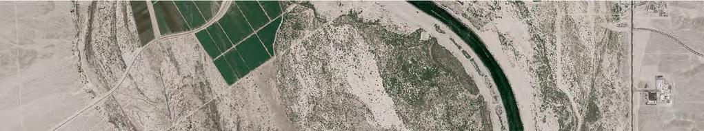
15 UV UV0 UV NEVADA UV ARIZONA UV UV CALIFORNIA 0 UV UV UV Map Extent Lake Mohave UV Source: ESRI data files, 00. G:\GIS_Production\Projects\RTC_00\Laughlin_Bridge_\_00_GIS_MODELS\_0_Map_Docs\_0_0_mxd\EA\Watershed_Arizona.mxd Last Updated : --0 N E V A D A C A L I F O R N I A O UV UV Hancock Marina Needles Highway ^_ ^_ Colorado Blvd. Riverview Veterans Memorial Bridge # Riverfront Drive ^_ Colorado River Needles Highway Lakeside Yale Drive Swan Drive ^_ Riviera Blvd. Bruce Woodbury Drive Lakeside Drive ^_ ^_ Ramar Road Hancock Road Marina Boulevard Riverview Drive Camino Del Rio ^_ Laughlin Rio Vis ta ^_ Dr. Lause Road UV ^_ # UV UV Rainbow Parkway Aztec Road Davis Dam Crossing (Closed Road) State High w Davis Da m Road ay # Silver Creek Bullhead City lvd. Arcadi a B Rainbow Drive North Casino D rive Existing Laughlin Bridge Colorado Rio Vista 0.. Miles UV Mc C ormick Boulevard Pass Canyon Rd. Bullhead Parkway Pass Canyon Silver Creek Road Bullh ea d Parkway A R I Z O N A ^_ Alternatives Study Limits Traffic Model Study Limits Proposed Bridge Locations # Existing Crossing Project Study Area FIGURE


16 Proposed Riverview Alternative Riverview Drive Source: Aerial Imagery NAIP, 00. Alignments from Jacobs Engineering, 00. G:\GIS_Production\Projects\RTC_00\Laughlin_Bridge_\_00_GIS_MODELS\_0_Map_Docs\_0_0_mxd\Section (f)\build_alternatives.mxd Last Updated : O NEVADA Needles Highway Aha Macav Parkway 0 00,00,00 Feet Proposed Roads Proposed Roads Colorado River Proposed Parkway Alternative UV Proposed Rainbow Alternative Rainbow Drive ARIZONA UV Bullhead Parkway Build Alternatives for Detailed Study in the Environmental Assessment FIGURE


17 G:\Projects\_Laughlin\Graphics\AI\Fig_typical_road_section_.ai Last Updated : -0-0 Westbound Eastbound Varies Varies ALL BUILD ALTERNATIVES TYPICAL ROADWAY SECTION NEVADA SIDE Feet Feet Note: Bridge cross section is for illustrative purposes only and does not limit the bridge type selection ALL BUILD ALTERNATIVES TYPICAL BRIDGE SECTION OVER RIVER Laughlin-Bullhead City Bridge Project Typical Street Section in Nevada and Bridge Section for all the Proposed Build Alternatives FIGURE


18 G:\Projects\_Laughlin\Graphics\AI\Fig_typical_road_section_.ai Last Updated : -0-0 DRIVE Westbound Eastbound Westbound Eastbound PROPOSED RIVERVIEW ALTERNATIVE WEST OF LAKESIDE DRIVE TYPICAL ROADWAY SECTION ARIZONA SIDE DRIVE Westbound Eastbound Westbound Eastbound PROPOSED RIVERVIEW ALTERNATIVE EAST OF LAKESIDE DRIVE TYPICAL ROADWAY SECTION ARIZONA SIDE Laughlin-Bullhead City Bridge Project Typical Street Section in Arizona for the Proposed Riverview Alternative FIGURE


19 G:\Projects\_Laughlin\Graphics\AI\Fig_typical_road_section_.ai Last Updated : -0-0 PROPOSED RAINBOW ALTERNATIVE TYPICAL ROADWAY SECTION ARIZONA SIDE PROPOSED PARKWAY ALTERNATIVE TYPICAL ROADWAY SECTION ARIZONA SIDE Laughlin-Bullhead City Bridge Project Typical Street Sections in Arizona for the Proposed Rainbow and Parkway Alternatives FIGURE
20 0 0 0 There are varying right-of-way (ROW) widths proposed for the three build alternative alignments. The proposed Riverview Alternative ROW in Nevada varies from 0 to 00 ft. wide. In Arizona, the proposed Riverview Alternative ROW varies between and ft. wide (Figure ). The proposed Rainbow Alternative ROW in Nevada varies from 0 to ft. wide. In Arizona, the proposed Rainbow Alternative ROW is ft. wide (Figure ). The proposed Parkway Alternative ROW in Nevada varies from 0 to 0 ft. wide. In Arizona, the Parkway Alternative ROW is 00 ft. wide (Figure ). The bridge would be constructed ft. wide (Figure ). The proposed project would generally be within currently established or future designated ROWs. Three proposed build alternatives, Riverview, Rainbow, and Parkway, are all being evaluated for potential Section (f) and (f) impacts and documented in both this report and this EA. With the No Build Alternative, there would be no impacts to Section (f) or Section (f) resources..0 IMPACTS METHODOLOGY AND EVALUATION To identify potentially affected Section (f) resources within the immediate study area of the three proposed build alternatives, an inventory and evaluation of parks, recreation areas, wildlife and waterfowl refuges, and historic sites were conducted. These resources were identified and evaluated through information obtained from agency coordination, local street maps, a tax assessor parcel-level Geographic Information System (GIS) database, and site visits. The inventory and evaluation process included such information as: size and ownership of recreational lands, types of recreational uses and facilities, unusual characteristics (e.g., steep slopes, flooding), types of improvements in process and/or proposed, types of access, functional classification (e.g., neighborhood, community, or regional park) and photographs of amenities. Potentially affected Section (f) resources within the immediate study area of the three proposed build alternatives are shown in Figure. The three proposed build alternatives were evaluated to determine whether a potential use of Section (f) or Section (f) resources would occur if the proposed project were constructed... Land Acquisition or Change in Land Use Areas proposed for development of the project s three proposed build alternatives were evaluated to determine whether a Section (f) or Section (f) resource would be subject to acquisition, alteration, or demolition. See Section.0.. ROW Acquisition and Displacements of this EA for more detailed information on the methodology. Preliminary engineering designs, surveyed aerial mapping, Mohave County assessor s maps, site visits, and a GIS dataset for the proposed project were used in the analysis to determine the extent of the land acquisition and potential direct impacts. Laughlin Bullhead City Bridge Project Section (f) and Section (f)


21 Arizona Veterans Memorial Proposed Riverview Alternative Riverview Drive Source: Aerial Imagery NAIP, 00. Alignments from Jacobs Engineering, 00. G:\GIS_Production\Projects\RTC_00\Laughlin_Bridge_\_00_GIS_MODELS\_0_Map_Docs\_0_0_mxd\Section (f)\affected_resources.mxd Last Updated : O NEVADA Needles Highway 0 00,00,00 Feet Aha Macav Parkway Proposed Roads Proposed Roads Rotary Park Colorado River Proposed Parkway Alternative Colorado River Nature Center UV Proposed Rainbow Alternative Rainbow Drive ARIZONA UV Bullhead Parkway Proposed Colorado River Heritage Greenway Trail Colorado River Nature Center Arizona Veterans Memorial Rotary Park Potentially Affected Section (f) Resources within the Immediate Study Area of the Proposed Build Alternatives FIGURE
22 Noise Projected noise levels for each of the three proposed build alternatives were evaluated to determine if the Section (f) or Section (f) resources would be adversely affected by future traffic noise within the immediate areas. See Section. Noise of this EA for more detailed information on the noise analysis methodology. For permanent or temporary" noise impacts, this project was evaluated using the Arizona Department of Transportation (ADOT) Noise Abatement Policy (NAP), approved on December, 00. An addendum to the 00 NAP (to update the barrier cost criterion) was approved on August, 00. Recreation areas, picnic areas, playgrounds, active sports areas, and parks are established within the Activity Category B, (exterior) dba for the land use noise abatement criteria. For these land uses with permanent or temporary impacts, noise levels must approach (within dba) or exceed dba to be considered for mitigation under the NAP. Additionally, mitigation will be considered for these properties if the predicted traffic noise levels substantially exceed existing levels. Substantially exceed is defined in the policy as a dba increase over existing noise levels. According to the Policy, for properties subject to Section (f) or Section (f) protection, potential project noise impacts must be evaluated by FHWA on a case-by-case basis to determine if there is a substantial impairment to the intended use of the resource property. For any constructive use impacts, this project was evaluated using FHWA NAP regulations Table of CFR part. Recreation areas, picnic areas, playgrounds, active sports areas, and parks are established within the Activity Category B, (exterior) dba for the land use noise abatement criteria. For these land uses with constructive use impacts, noise levels must exceed dba to be considered for mitigation under the Noise Abatement Policy. Additionally, mitigation will be considered for these properties if the predicted traffic noise levels substantially exceed existing levels. Substantially exceed is defined in the policy as a dba increase over existing noise levels... Visual Resources Potential visual impacts were evaluated by comparing existing visual conditions with the projected future conditions that would be anticipated with the implementation of the three proposed build alternatives at the Section (f) or Section (f) resources. Potential permanent visual impacts were evaluated to determine if they would substantially impair the value of the resource. See Section. Visual Resources of this EA for more detailed information... Mobility and Access Potential changes to mobility and access were evaluated by comparing the existing roadway and bicycle networks, pedestrian routes, and watercraft routes with the proposed project. Potential permanent changes in vehicle/bicycle/pedestrian/watercraft mobility within and access to Section Laughlin Bullhead City Bridge Project Section (f) and Section (f)
23 0 0 0 (f) or Section (f) resource areas were evaluated to determine if they would substantially impair the value of the resource. See Section... Bridge Design and Section. Mobility and Access of this EA for more detailed information... Public Safety Potential changes to public safety within the Section (f) or Section (f) resource areas were evaluated by comparing the existing emergency response routes or facilities with the routes of the proposed project surface transportation system. Potential permanent changes in the delivery of emergency services or public safety facilities within the Section (f) or Section (f) resource areas were evaluated to determine if they would substantially impair the value of the resource. See Section. Safety of this EA for more detailed information..0 PARKS AND RECREATIONAL RESOURCES ASSOCIATED WITH THE PROPOSED RIVERVIEW ALTERNATIVE The following Section (f) and Section (f) resources are associated with the proposed Riverview Alternative within the Arizona portion of the immediate study area. There are no historic or architectural properties, wildlife or waterfowl refuges, or existing or planned public school sites associated with the Riverview Alternative. None of these resources are located within the Laughlin portion of the immediate study area... Rotary Park Rotary Park, the largest park in Bullhead City, is located about a mile west of SR and is bordered by Lakeside Drive on the east, Riverview Drive on the north, and the Colorado River on the southwest (Figure ). This -acre regional park is BOR withdrawn land administered by the BLM and is leased (Attachment --AZA ) to the City of Bullhead City. According to the Bullhead City 00 General Plan, this land has been designated as Park/Open Space on the land use map. Rotary Park is accessible by vehicles/bicycles/pedestrians from Lakeside and Riverview drives, and by watercraft along the Colorado River. Rotary Park has a number of recreational facilities, including basketball courts; softball, baseball, and soccer fields; a covered playground; skate park; amphitheater; model airplane runway; and a marina and non-motorized boat launch with picnic areas, gazebos, and ramadas. Additionally, numerous natural interpretive trails/paths (known as the Riverview Trail running along the river) join the northeast corner of the park that connects to the Colorado River Heritage Greenway Trail (Heritage Trail). According to the Rotary Park Plan Update 00, a dog park, disc golf turf, exercise stations, additional volleyball and soccer fields, and a fishing platform are planned for the park (Bullhead City 00) (Figure Laughlin Bullhead City Bridge Project Section (f) and Section (f)
24 0 0 0 ). The current park master plan would be revised based on project-related coordination between the Laughlin Bullhead City Bridge Project IDT and the Bullhead City Parks, Recreation, and Community Services Department (PRCSD) if this proposed Alternative would be selected. As part of the Rotary Park planning process (Rotary Park Plan Update 00), a section traversing the entire northern border of the park was reserved for a bridge and roadway to Laughlin. The Rotary Park Plan Update 00 includes an exhibit showing a possible bridge location at the northwest corner of the park, following the Riverview Alternative. According to the plan update, the bridge would need to be designed to have minimal disturbance with the park, and would need to provide accessibility for the Riverview Trail that would extend under the bridge and over the channel to the marina and future developments. In 00, Rotary Park received a (National Park Service, Land and Water Conservation Fund [LWCF]) grant, which is Section (f) funding, to install soccer field lighting.... Potential Impacts to Rotary Park... Land Acquisition or Change in Land Use or Amenities The. acres of Rotary Park land that would be required for the project include primarily vacant parklands and a small peripheral portion of the future planned disc golf turf along the northern border of the park according the Rotary Park Plan Update (Figure ). This required land would be located south from the existing Riverview Drive between the river and Lakeside Drive (Figure ) (LBHCBP 00c). This land acreage estimate is based on an initial acquisition and conversion of. acres of Rotary Park (Table ). Also, there would be an acquisition of the entire.-acre private parcel (Mohave County Assessor Parcel #--0) near the river and the most northwestern area of Rotary Park. However, this full parcel acreage (. acres) is not required for the proposed Riverview Alternative, only 0. acres is required, thus leaving a remaining 0. acre that would be reverted from a transportation use back to Rotary Park (a net gain). This gain (0. acre) added to the required. acres equates to the total of. acres of Rotary Park that would be required and have a Section (f) land use impact. In addition, the park main entrance sign would need to be relocated (Appendix F Photo ). Bullhead City has anticipated this in their PWD and PRCSD planning (Agrawal 00). Although Rotary Park received a LWCF grant [Section (f) lands] to install soccer field lighting, the lighting is not impacted by this project. Laughlin Bullhead City Bridge Project Section (f) and Section (f) 0

25 Source: RBF; 00 G:\Projects\_Laughlin\Graphics\AI\Fig0_RotaryPark_PlanUpdate.ai Last Updated : Laughlin-Bullhead City Bridge Project Rotary Park Plan Update 00 FIGURE
. Private parcel reverted from transportation use (net benefit recreation use for Rotary <0.> Park) Recreation Use Subtotal.")
26 Table. Rotary Park and Private Parcel Land Use Impacts for the proposed Riverview Alternative Land Acquisition Acreage Rotary Park (recreation use). Private Parcel (transportation use). Initial Subtotal. Rotary Park (recreation use). Private parcel reverted from transportation use (net benefit recreation use for Rotary <0.> Park) Recreation Use Subtotal. Private Parcel (transportation use) 0. Final Subtotal. Photo. Rotary Park Main Sign Laughlin Bullhead City Bridge Project Section (f) and Section (f)


27 Source: Aerial Imagery from USDA NAIP 00. Alignments from Jacobs Engineering, 00. \\sdg-gis\projects\_laughlin\map_docs\figures\sectionf\rotary_park_00.mxd Last Updated : -0-0 Proposed Riverview Alternative Riverview Drive Bridge Abutments and Piers Rotary Park Co O 0 0 lor ado R iv er 00 Feet Rotary Park: Potential Section (f) Land Acquisition Impacts FIGURE
28 Noise Existing noise level readings were taken at two monitoring sites (M- and M-) within Rotary Park. The monitoring sites are described below in Table (see Section. Noise and Figure a-e of this EA for additional details). Table. Existing Noise Monitoring Results for Rotary Park Monitoring Site Location Ambient Noise Level a M- Riverview Alternative at Rotary Park near residences M- Riverview Alternative at Rotary Park near Colorado River a measured in dba L Aeqh Four sensitive noise receivers (RIV-A, RIV-, RIV-, RIV-, AND RIV-) were established within active recreational areas of Rotary Park and evaluated from a traffic noise perspective for the 00 peak-hour traffic conditions. The results of the noise analysis are indicated below in Table and the locations of the receivers are shown in Figure a-e of this EA. RIV-, which is located at the northern extent of the ball fields within Rotary Park, would approach (within dba) but not exceed the ADOT noise abatement criterion (NAC) (established land use category B of dba). According to the ADOT NAP, noise barriers will be constructed to mitigate noise impacts unless the majority of impacted customers are opposed to their construction. Opposition to barrier construction shall be documented in writing, such as formal surveys or petitions, and shall be compiled by the local jurisdiction, landowner association, neighborhood representative, or ADOT. In this case, Bullhead City is responsible for planning and operating Rotary Park and has opposed the construction of a potential noise barrier, which would screen the park from the roadway (Leuck 00).... Visual Resources The visual resources assessment included an evaluation of existing visual conditions through an examination of landscape character and scenic quality as well as an impact assessment using a visual contrast and viewer sensitivity evaluation to assess: Inherent aesthetics within the landscape; Project visibility and viewer sensitivity to change; Visual contrast; and The impact of human modification to the natural landscape. Typical views, called key observation points (KOPs), were selected in the study area to represent different types of views. KOPs were selected in populated or commonly utilized areas where people could possibly have a view of the project. These areas include residential communities, recreational areas, and commonly traveled roads. The viewer sensitivity analysis determines the classes of viewers or viewer groups that would experience the visual landscape. That is, viewer Laughlin Bullhead City Bridge Project Section (f) and Section (f)
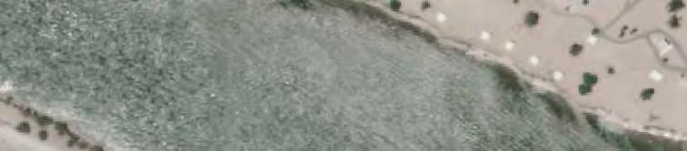
29 0 0 Table. Noise Analysis Results for Rotary Park Receiver Distance from proposed Riverview Alternative Centerline (feet) 00 Unmitigated Build Condition (dba-l Aeqh ) 00 Mitigated Build Condition (dba-l Aeqh ) Mitigation Considerations a RIV-A south NA None warranted below NAC a RIV- north NA None warranted below NAC RIV- 0 south NA None warranted below NAC RIV- 0 south NA None warranted below NAC RIV- south Potential Barrier BHC PRCSD opposed barrier construction at this location a ADOT noise abatement criteria (NAC) for permanent use impact of the park, noise levels must approach (within dba) or exceed dba L Aeqh sensitivity establishes what the visual response is to the introduction of the proposed project in the viewshed. Viewer sensitivity was established by evaluating the type of viewer and their proximity to the proposed project. Viewer sensitivity is influenced by existing topography, vegetation, and urban development or structures. Viewer sensitivity is ranked from high to low, high being the most sensitive viewing condition. The viewer sensitivity analysis also considers the frequency, duration, and type of viewing conditions. Additionally, viewer sensitivity is impacted by viewer activity, awareness, perception, and visual expectations. Recreationalists were considered to have a medium sensitivity rating (see Section. Visual Resources of this EA for additional details). KOP was located in Rotary Park near the edge of the Colorado River. The distance from this KOP to the proposed bridge is approximately 0. mile (00 feet). This KOP was chosen because recreational viewers on the river or those using park facilities (such as the beach or picnic ramadas) are rated at medium viewer sensitivity. From this location, the view is to the northwest and looks over the river. The river is visible in the immediate foreground, open desert is visible in the middleground, and Dead Mountain Range is visible in the background (Photo ). A simulation of the proposed bridge was performed for this KOP (Photo ). The proposed bridge would introduce a strong horizontal line and several smaller vertical lines into the immediate foreground. Given that there are no other adjacent vertical structures that span the river, the visual contrast of the bridge would be strong (Photos and ). Based on KOP, the bridge would produce a moderate level of visual change for recreationalists (with a medium viewer sensitivity rating) utilizing the river and adjacent public areas. The Laughlin Bullhead City Bridge Project Section (f) and Section (f)

 for the proposed Riverview Alternative would restrict some pedestrian, bicycle, and vehicular access from driveways and streets directly")
30 proposed roadway would not likely be seen due to the difference in elevations and therefore would not produce a level of change for the viewers. Photo. KOP is a representative view from Colorado River banks along Rotary Park at the proposed Riverview Alternative Photo. Simulation of the proposed Riverview Alternative at KOP 0... Mobility and Access Mobility and access to and within the park and parking lots would be maintained for watercraft, vehicles, bicycles, and pedestrians. The proposed roadway design configurations (frontage roads) for the proposed Riverview Alternative would restrict some pedestrian, bicycle, and vehicular access from driveways and streets directly accessing Rotary Park, which might be considered as disturbing the peace, harmony, and lifestyle of families who live there. For pedestrians utilizing the proposed designated cross-walks for direct access to Riverview Drive Laughlin Bullhead City Bridge Project Section (f) and Section (f)
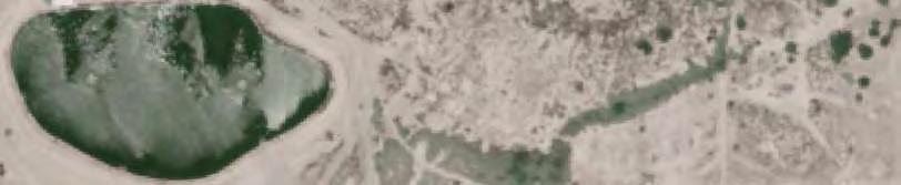
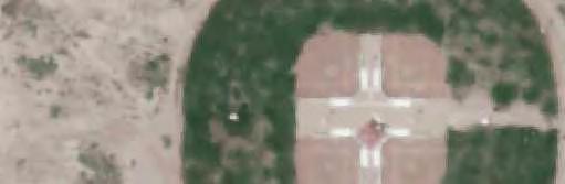
31 0 0 0 and Rotary Park, it would require travel rerouting up to approximately 0. mile which equates to. minutes of additional time for pedestrians at a walking pace of feet/second (worst-case scenario if your residence is located at the mid-point of the neighborhood near Riverview Way). Requests from and coordination with Bullhead City staff has ensured that potential trail connections would be maintained (including under the proposed bridge) and would provide increased access. Bullhead City PRCSD staff is considering a pedestrian bridge connection between the most northwest portion of Rotary Park and the southern most portion of the Arizona Veterans Memorial Park to provide another connection for the Colorado River Heritage Greenway Trail network. Mobility and access would also be increased based on the construction of a -foot multi-use pathway associated with the proposed Riverview Alternative along the northern border of Rotary Park. These new connections would increase recreational opportunities and enhance regional connectivity between park users of both Laughlin and Bullhead City.... Public Safety Public safety access to and within Rotary Park would be maintained for emergency service vehicles (police, fire, and ambulance). The proposed Riverview Alternative would increase traffic along the alignment. This increase may adversely affect the actual or perceived safety of persons walking, crossing, or riding bicycles along this road to get to Rotary Park. With the proposed build alternative, sidewalks, multi-use pathway, cross-walks, and potentially warranted signalized intersections would create safer benefits for access management of people, bicycles, and vehicles... Arizona Veterans Memorial Park The Arizona Veterans Memorial Park in Bullhead City is located on a -acre site along the Colorado River. The Park includes: a beach, ramadas, a speakers gazebo, two pedestrian bridges, memorial plaza with a fountain and monument with the names of the fallen, beneath nine flags including: American, Arizona, American Legion, Army, Navy, Marine Corps, Air Force, Coast Guard and Prisoners Of War. As planned, the park was created from Arizona state trust land, and includes a monument built on an out-cropping of land between two bays and faces out toward the Colorado River, providing a dramatic venue for the monument (Photo ). The "Trail of Memories" will be a key element in the Arizona Veterans Memorial, extending over,00 feet through the memorial park, passing by monuments to Congressional Medal of Honor winners and ending at the Arizona Veterans Memorial Plaza (Photo ), containing names of over,000 fallen service men and women from World War I to present. Laughlin Bullhead City Bridge Project Section (f) and Section (f)

 and the Arizona Veterans Memorial Plaza to provide another connection for the Colorado River Heritage Greenway Trail network.")
32 0... Potential Impacts to Arizona Veterans Memorial Park... Land Acquisition or Change in Land Use or Amenities The proposed Riverview Alternative would not require an acquisition or conversion, change in land use or amenities of this recreational park. Bullhead City PRCSD staff is considering a pedestrian bridge connection between the most northwest portion of Rotary Park (this land is what would be reverted from right-of-way acquisition of the private parcel to construct the proposed Riverview Alternative) and the Arizona Veterans Memorial Plaza to provide another connection for the Colorado River Heritage Greenway Trail network. This pedestrian walkway would increase recreational opportunities. Photo. Sky view of Arizona Veterans Memorial Park looking south Photo. Arizona Veterans Memorial Plaza Laughlin Bullhead City Bridge Project Section (f) and Section (f)
33 Noise An existing noise level reading was taken at one monitoring site (M-) as described in Table within Rotary Park. This ambient noise level reading ( dba) would be acoustically equivalent and was used for the Arizona Veterans Memorial Park due to the similar location along the Colorado River within a nearby park within an area of similar activity. A sensitive noise receiver (RIV-) was established within Arizona Veterans Memorial Plaza in the potential noise sensitive recreational area (potential noise conflicts between speakers/attendees at a memorial service vs. project traffic noise on a new bridge). This receiver was evaluated from a traffic noise perspective for the 00 peak hour traffic condition. The results of the noise analysis are indicated below in Table and the locations of the receiver is shown in Figure a-e of this EA. Table. Noise Analysis Results for Arizona Veterans Memorial Park Receiver Distance from Proposed Riverview Alternative Centerline (feet) 00 Unmitigated Build Condition (dba-l Aeqh ) 00 Mitigated Build Condition (dba-l Aeqh ) RIV- south NA Mitigation Considerations a None warranted below NAC a FHWA noise abatement criteria for constructive use impact of the park, noise levels must exceed dba L Aeqh RIV- would not exceed the FHWA mitigation criterion (NAC established land use category B of dba). Therefore, the proposed Riverview Alternative would not have a constructive use noise impact to Arizona Veterans Memorial Park.... Visual Resources The visual resources assessment included an evaluation of existing visual conditions through an examination of landscape character and scenic quality as well as an impact assessment using a visual contrast and viewer sensitivity evaluation to assess: Inherent aesthetics within the landscape; Project visibility and viewer sensitivity to change; Visual contrast; and The impact of human modification to the natural landscape. Typical views, called key observation points (KOPs), were selected in the study area to represent different types of views. KOPs were selected in populated or commonly utilized areas where people could possibly have a view of the project. These areas include residential communities, recreational areas, and commonly traveled roads. The viewer sensitivity analysis determines the classes of viewers or viewer groups that would experience the visual landscape. That is, viewer Laughlin Bullhead City Bridge Project Section (f) and Section (f)
34 0 0 sensitivity establishes what the visual response is to the introduction of the proposed project in the viewshed. Viewer sensitivity was established by evaluating the type of viewer and their proximity to the proposed project. Viewer sensitivity is influenced by existing topography, vegetation, and urban development or structures. Viewer sensitivity is ranked from high to low, high being the most sensitive viewing condition. The viewer sensitivity analysis also considers the frequency, duration, and type of viewing conditions. Additionally, viewer sensitivity is impacted by viewer activity, awareness, perception, and visual expectations. Recreationalists were considered to have a medium sensitivity rating (see Section. Visual Resources of this EA for additional details). KOP was located in the Arizona Veterans Memorial Plaza. The distance from this KOP to the proposed bridge is approximately 0.0 mile (0 feet). This KOP was specifically chosen because recreational viewers at the plaza have a dramatic scenic venue for viewing the monument and are rated at medium viewer sensitivity. From this location, the view is to the south towards the memorial and Rotary Park. The memorial is visible in the immediate foreground, small portions of Rotary Park and the Colorado River are visible in the middleground, and Dead Mountain Range is visible in the background (Photo ). A simulation of the proposed bridge was performed for this KOP (Photo ). The proposed bridge would introduce a strong horizontal line and several smaller vertical lines into the immediate foreground. Given that there are no other adjacent vertical structures that span the river, the visual contrast of the bridge would be strong (Photos and ). Based on KOP, the bridge would produce a major level of visual change for recreationalists (with a medium viewer sensitivity rating) utilizing the park, the plaza, adjacent public areas, and the river. The proposed roadway would not likely be seen due to the difference in elevations and therefore would not produce a level of change for the viewers. Laughlin Bullhead City Bridge Project Section (f) and Section (f) 0
 Mobility and access to and within the Arizona Veterans Memorial Park and parking lots would be maintained for watercraft, vehicles,")
 and would provide increased access.")
35 Photo. KOP is a representative view from the plaza at Arizona Veterans Memorial Park at the proposed Riverview Alternative Photo. Simulation of the proposed Riverview Alternative at KOP 0... Mobility and Access (Vehicular, Bicycles, and Pedestrians) Mobility and access to and within the Arizona Veterans Memorial Park and parking lots would be maintained for watercraft, vehicles, bicycles, and pedestrians. Requests from and coordination with Bullhead City staff has ensured that potential park connections would be maintained (including under the proposed bridge) and would provide increased access. Bullhead City PRCSD staff is considering a pedestrian bridge connection between the most northwest portion Rotary Park and the southern most portion of the Arizona Veterans Memorial Park to Laughlin Bullhead City Bridge Project Section (f) and Section (f)
36 0 0 provide another connection for the Colorado River Heritage Greenway Trail network. This would enhance regional connectivity between park users of both Laughlin and Bullhead City.... Public Safety Public safety access to and within Arizona Veterans Memorial Park would be maintained for emergency service vehicles (police, fire, and ambulance)... Colorado River Heritage Greenway Trail The Colorado River Heritage Greenway Trail Project is a community-based effort to establish a river and land trail system for the residents and visitors of Bullhead City. The trails will link canoeists, kayakers, boaters, walkers, bicyclists to the region's family of parks including Lake Mead National Recreation Area, Davis Camp, Community Park, Rotary Park, Ken Fovargue Park and the Colorado River Nature Center (as shown in Figure and Attachment ). In July, The City of Bullhead City applied for planning assistance from the National Park Service Rivers, Trails, and Conservation Assistance Program (RTCA). RTCA began facilitating a community-based planning process in January. Planning costs are kept to a minimum through a collaborative private/public partnership. Implementation of the greenway project would be funded through private and public sources, such as grants, city funding, local donations, etc. A Colorado River Heritage Greenway Master Plan was developed for the Bullhead City PRCSD and the Colorado River Heritage Greenway Trail Association in October 00. The River Trail will travel along the Colorado River by Rotary Park in Bullhead City. Residents and visitors already enjoy fishing, jogging, and biking in the area, however, a lack of access paths and signage make it hard for many people to follow the trail (Photo ). The additional recreational amenities will be a significant addition to the community. Local citizens, business owners and government officials are working together to develop this plan. The Rivers, Trails, and Conservation Assistance Program of the National Park Service has also been instrumental in the development of the Greenway. Numerous other stakeholders, such as the AGFD, the Bureau of Reclamation (USBOR), the BLM and many other groups are involved in the process of bringing a trail system to Bullhead City. Laughlin Bullhead City Bridge Project Section (f) and Section (f)

37 Photo. Segment of Colorado River Heritage Greenway Trail 0 0 This system of improved hiking trails offers several short hikes in various locations throughout Bullhead City, and includes the only designated water trail system in the state of Arizona. Four segments of the trail have been completed to date, with trailheads located at Davis Camp, Heritage Park (just south of the Laughlin Bridge), Ken Fovargue Park and Rotary Park. Kayak rentals and tours are available, or visitors may bring their own watercraft and launch at Davis Camp, Bullhead Community Park or Rotary Park. Small, non-motorized crafts can be launched at several other locations in the area as well.... Potential Impacts to the Colorado River Heritage Greenway Trail... Land Acquisition or Change in Land Use or Amenities Trail connections for this portion of the Colorado River Heritage Greenway Trail are currently constructed within Rotary Park. Engineering design considerations were implemented so that the proposed Riverview Alternative would not require an acquisition or conversion, change in land use or amenities of this recreational area.... Noise and Visual Resources Potential noise and visual impacts to recreationalists using the Colorado River Heritage Greenway Trail from the proposed Riverview Alternative would be similar to those previously discussed in Section... This is due to the fact that the trail is constructed within the same nearby areas as those discussed for Rotary Park. However, recreational trail users vary from the typical, more stationary park users. They tend to have less extended exposure time to the noise impacts and viewshed due to constant motion and they tend not to be exclusively focused on the surrounding scenery.... Mobility and Access Mobility and access to and within the planned trail would be maintained for bicycles and pedestrians. Requests from and coordination with Bullhead City staff has ensured that potential Laughlin Bullhead City Bridge Project Section (f) and Section (f)
38 0 0 0 trail connections would be maintained (including under the proposed bridge) and would provide increased access. Bullhead City PRCSD staff is considering a pedestrian bridge connection between the most northwest portion Rotary Park and the southern most portion of the Arizona Veterans Memorial Park to provide another connection for the Colorado River Heritage Greenway Trail network. This new connection would increase recreational opportunities and enhance regional connectivity between park users of both Laughlin and Bullhead City.... Public Safety Public safety access to the Colorado River Heritage Greenway Trail would be maintained for emergency service vehicles (police, fire, and ambulance)... Impact Avoidance, Minimization, and Mitigation or Enhancement Measures for Rotary Park, Arizona Veterans Memorial Park, and the Colorado River Heritage Greenway Trail No specific impact avoidance, minimization, and mitigation or enhancement measures have been requested from Bullhead City or BLM (land owner and/or administrators with jurisdiction). However, the following had been proposed in support of a Section (f) de minimis determination based on identified concerns (Attachment ). The chosen Laughlin Bullhead City Bridge project proposed potential preferred alternative (proposed Riverview Alternative) has been designed in such a way as to avoid Section (f) and Section (f) properties to the greatest extent possible. Previous designs that included phasing four and six travels lanes with a m.p.h. design speed, would have potentially impacted. and 0. acres, respectively for Rotary Park. The current refined design is only for four travel lanes with a m.p.h. design speed, this avoidance would now potentially impact. acres of Rotary Park. This design also avoids previously impacted park amenities such as the beach, picnic armadas, ball fields, and trails (Figure ). The proposed Riverview Alternative is designed utilizing all of the existing -foot ROW along Riverview Drive thereby minimizing new land use impacts for ROW, cuts, fills, and other design impacts. Also, the bridge and roadway approach have been designed utilizing retaining walls and reduced medians which minimize the footprint/impact area to Rotary Park. Several enhancements or positive effects would result from the implementation of the proposed Riverview Alternative. The proposed Riverview Alternative includes creating a continuous ADA compliant -foot multi-use pathway along the northern edge of Rotary Park which provides a safer and more accessible route to the park for the pedestrians and bicycles of the nearby neighborhood, Bullhead City, and Laughlin. Also, a new warranted traffic signal would be placed at the Balboa Drive/Riverview Drive entrance to Rotary Park thus controlling and improving access for vehicles and pedestrians. Access to amenities in the park, including the Colorado River Heritage Greenway Trail, would be increased. Laughlin Bullhead City Bridge Project Section (f) and Section (f)


39 Source: Aerial Imagery from Clark County GIS, 00. Alignments from Jacobs Engineering, 00. \\sg:\projects\_laughlin\map_docs\anders_working\rotary_park_comparison.mxd Last Updated : Feet O Current Configuration Previous Configuration Proposed Riverview Alternative Design Comparisons FIGURE
40 0 0 0 Bullhead City believes the previously proposed Riverview alignment design had minimal impacts to its park resources, however they have made considerable efforts on their part to develop possible additional actions to further avoid, minimize, and mitigate potential negative impacts to Rotary Park while also providing enhancements. To date, staff has met with four out of five of the following Rotary Park user groups: Colorado River Heritage Greenway Trail Association, ASA Girl s softball, AYSO Soccer, Pop Warner Football and the Fun Flyers Club for recommendations. Bullhead City staff and City Council have provided the following items for consideration prior to and then gaining public approval:. Increase the number of picnic ramadas along the beach areas within the park.. Extend the trail, via pedestrian bridges into the Arizona Veterans Memorial as part of the Colorado River Heritage Greenway Trail.. Install exercise stations along the existing trails.. Provide additional improvements to the softball field complex such as new parking, shade covers, storage building, fencing and utility improvements.. Complete construction of four new ball fields prior to project completion.. Design and incorporate aesthetic treatments to enhance the appearance of the bridge.. Complete construction of Balboa Drive from Riverview Drive through the park to Lakeside Drive prior to construction of the bridge and per the park s master plan.. Install security lighting under the bridge and along the trails.. Install a seawall and backfilling with sand at the Don Sullivan Non-motorized Boat Launch to create a usable beach and increase beach acreage. 0. Relocate the park s monument sign at the Riverview Drive/Lakeside Drive intersection. Once agency and public consensus would be reached, BHC committed that these items would be in place prior to completion of the Laughlin Bullhead City Bridge Project. BHC felt strongly that the enhancements being considered for the park, as a result of the proposed Riverview Alternative, along with the planned additions, modifications, and growth of this park, would increase it s usefulness to the public from both communities, particularly following the construction of the bridge between the two jurisdictions. The costs associated with these proposed mitigation and enhancements have been included as 0% contingency in the total estimated project costs for construction. The current Memorandum of Agreement between the RTCSNV, City of Bullhead City, and Laughlin/Clark County is being amended to include funding commitments for project costs that exceed federal funding... Agency Coordination and Public Involvement for Rotary Park, Arizona Veterans Memorial Park, and the Colorado River Heritage Greenway Trail The proposed project is currently being coordinated with (but not limited to) U.S. Army Corps of Engineers (USACE); U.S. Coast Guard (USCG); USBOR; U.S. Fish & Wildlife Service Laughlin Bullhead City Bridge Project Section (f) and Section (f)
41 0 0 0 (USFWS); BLM Lake Havasu Field Office; local and regional Native American Tribes; NDOT; Nevada State Historic Preservation Office; Nevada Division of State Parks; Nevada Department of Wildlife; ADOT; Arizona State Historic Preservation Office; Arizona State Land Department; Arizona Game and Fish Department (AGFD); RTCSNV; Mohave County, Arizona; Clark County, Nevada; Town of Laughlin, Nevada; and Bullhead City, Arizona. The project IDT has met for regularly scheduled (usually monthly or as warranted) meetings since the projects inception. In addition, several coordination meetings and efforts have occurred specifically with the BLM Lake Havasu Field Office and Bullhead City regarding the potential Section (f) impacts from the Riverview Alternative to Rotary Park and Arizona Veterans Memorial Park (as discussed in Section.0 Agency Coordination and Public Involvement Efforts Summary above). The BLM Lake Havasu Field Office was informed of the intent to make a de minimis determination. The IDT requested additional formal documentation from Bullhead City Parks & Recreation Commission and City Council regarding their support or opposition for a Section (f) de miminis finding. This occurred at the BHC Parks & Recreation Commission meeting on November, 00 (Attachment ) and the BHC City Council meeting on December, 00 (Attachment ). Both the Commission and the Council supported a Section (f) de miminis finding. PRCSD staff has met with four out of five of the following Rotary Park user groups: Greenway Trail Association, ASA Girl s softball, AYSO Soccer, Pop Warner Football and the Fun Flyers Club. Discussions included possible actions to minimize, avoid, and mitigate potential negative impacts and create enhancements for Rotary Park. Two Public Informational Meetings were held for the proposed project on July and, 00. A Proposed Riverview Alternative Neighborhood Meeting was conducted on May, 00 at the Bullhead City Building, Clearwater Drive. Two additional Public Informational Meetings were held on August and, 00. Also, RTCSNV staff conducted door-to-door neighborhood surveys in Bullhead City on June & 0 and July, 00. Approximately,00 flyers were sent out in advance as a double-sided form in both English and Spanish. The study area for this survey was a corridor extending ½- mile both north and south of each of the three proposed alternatives (Riverview, Rainbow, and Parkway). The RTCSNV conducted the door-to-door survey systematically and based around pre-established appointments that were received on the telephone number provided on the flyers (about 00 calls received to date and still receiving some) for this task. The RTCSNV also conducted the surveys over the phone when that method was the preferred by individuals. When the RTCSNV did not make contact at the residence, a comment card ( Sorry We Missed You ) was left behind for the people to respond to. The RTCSNV directly contacted about 00 residences during the process. The survey questions were tailored for each residence based on the closest of the three alternatives to their property. The RTCSNV had two survey teams, and Laughlin Bullhead City Bridge Project Section (f) and Section (f)
42 0 0 0 each consisted of one man and one woman, of which one of the individuals spoke fluent Spanish. The RTC teams only spoke Spanish at approximately five residences and these people also spoke fluent English, but preferred Spanish. The people that the RTCSNV had contact with were very appreciative of the process and that their comments would be included in the project; some of them had never attended the previous public meetings nor provided comments in the past. At all of these meetings, the public was informed of the intent to make a de minimis determination and the potential project impacts. Comments have been received with support and opposition for the proposed project. All received comments are included and summarized in Appendix H of this EA. In addition, agency coordination efforts are further summarized above in Section.0 Agency Coordination and Public Involvement Efforts Summary... Section (f) De Minimis Determination for Rotary Park As indicated above in Section.0 Agency Coordination and Public Involvement Efforts Summary, it was formally concluded for a second time that a Section (f) de minimis determination cannot be sustained for the potential impacts (noise, visual, and land use) to Rotary Park from the proposed Riverview Alternative. Therefore, it can no longer be considered as a viable proposed build alternative in this EA... Section (f) Constructive Use Recommendation for Arizona Veterans Memorial Park The proposed Riverview Alternative would not have a constructive use noise impact to Arizona Veterans Memorial Park. However, the bridge would produce a major level of visual change for recreationalists (with a medium viewer sensitivity rating) utilizing the plaza. This would be considered a potential constructive use visual impact because it substantially impairs the esthetic features of the plaza... Section (f) Constructive Use Recommendation for Colorado River Heritage Greenway Trail The proposed Riverview Alternative would not have constructive use impacts to the Colorado River Heritage Greenway Trail..0 PARKS AND RECREATIONAL RESOURCES ASSOCIATED WITH THE PROPOSED RAINBOW ALTERNATIVE The following Section (f) resources are associated with the proposed Rainbow Alternative within the Bullhead City portion of the immediate study area. There are no Section (f) resources, historic or architectural properties, or existing or planned public school sites Laughlin Bullhead City Bridge Project Section (f) and Section (f)
43 0 0 0 associated with the proposed Rainbow Alternative. None of these resources are located within the Laughlin portion of the immediate study area... Colorado River Heritage Greenway Trail This same trail is previously discussed above in Section. Colorado River Heritage Greenway Trail. Currently, this portion of the trail is not constructed within the area of the proposed Rainbow Alternative. However, a future connection is proposed shown on Figure and Attachment.... Potential Impacts to the Colorado River Heritage Greenway Trail... Land Acquisition or Change in Land Use or Amenities Engineering design considerations were implemented so that the proposed Rainbow Alternative would not require an acquisition or conversion, change in land use or amenities of this recreational area. Requests from and coordination with Bullhead City staff has ensured that potential trail connections would be maintained (including under the proposed bridge) and would provide increased access.... Noise and Visual Resources Potential noise and visual resources impacts to recreationalists using the Colorado River Heritage Greenway Trail from the proposed Rainbow Alternative were not evaluated because users would have extremely limited interaction at this location. Recreational trail users differ from the typical more stationary park users. They tend to have less extended exposure time to the noise impacts and viewshed due to constant motion and they tend not to be exclusively focused on the surrounding scenery. This is evident due to the fact that this planned portion of the trail would cross the proposed Rainbow Alternative at only one small location in a north-south direction.... Mobility and Access Mobility and access to and within the future planned trail would be maintained for bicycles and pedestrians. In fact, mobility and access would be increased based on the construction of a -foot multi-use pathway associated with the proposed Rainbow Alternative along the southern border of the project. Thus, it provides another connection opportunity for the trail network. This would enhance regional connectivity between park users of both Laughlin and Bullhead City.... Public Safety Public safety access to the Colorado River Heritage Greenway Trail would be maintained for emergency service vehicles (police, fire, and ambulance). Laughlin Bullhead City Bridge Project Section (f) and Section (f)
44 Impact Avoidance, Minimization, and Mitigation or Enhancement Measures for the Colorado River Heritage Greenway Trail The activities, features, and attributes of the Colorado River Heritage Greenway Trail would not be impaired. No specific impact avoidance, minimization, and mitigation or enhancement measures have been requested from Bullhead City (official with jurisdiction). However, the proposed Rainbow Alternative has been designed in such a way as to avoid and/or minimize Section (f) and Section (f) properties to the greatest extent possible. Potential trail connections would be maintained and provide increased access. Mobility and access would also be increased based on the construction of a -foot multi-use pathway associated with the proposed Rainbow Alternative along the southern border of the project. Thus, it provides another connection opportunity for the Colorado River Heritage Greenway Trail network. This would enhance regional connectivity between park users of both Laughlin and Bullhead City... Agency Coordination and Public Involvement for the Colorado River Heritage Greenway Trail The proposed project is currently being coordinated with (but not limited to) U.S. Army Corps of Engineers (USACE); U.S. Coast Guard (USCG); USBOR; U.S. Fish & Wildlife Service (USFWS); local and regional Native American Tribes; NDOT; Nevada State Historic Preservation Office (SHPO); Nevada Division of State Parks; Nevada Department of Wildlife; ADOT; Arizona State Historic Preservation Office; Arizona State Land Department; AGFD; RTCSNV; Mohave County; Clark County; Town of Laughlin, and Bullhead City. As previously discussed (Section. Agency Coordination and Public Involvement for Rotary Park, Arizona Veterans Memorial Park, and the Colorado River Heritage Green Trail), the project IDT has met for regularly scheduled (usually monthly or as warranted) meetings since the projects inception. Four Public Informational Meetings were held for the proposed project, in addition to the RTCSNV staff conducting door-to-door neighborhood surveys in Bullhead City. At all of these meetings and during the survey process, the public was informed of the potential project impacts. Comments have been received with support and opposition for the proposed project. All received comments are included and summarized in the Section.0 Agency Coordination and Public Involvement of this EA. An Agency Scoping Meeting was held on July, 00 from :00 to :00 p.m. at the Bullhead City Hall Council Chambers, Marina Blvd., in Bullhead City, Arizona. The PMT briefed a representative from the AGFD on the project. Several resource agencies (USACE, USCG, and BLM) have been active participants, as applicable, on the IDT throughout the project development process. Laughlin Bullhead City Bridge Project Section (f) and Section (f) 0
45 0 0 In addition, coordination and efforts have occurred specifically with Bullhead City regarding the potential Section (f) issues impacts from the proposed Rainbow Alternative to the Colorado River Heritage Greenway Trail... Section (f) Constructive Use Recommendation for Colorado River Heritage Greenway Trail The proposed Rainbow Alternative would not have constructive use impacts to the Colorado River Heritage Greenway Trail..0 PARKS AND RECREATIONAL RESOURCES ASSOCIATED WITH THE PROPOSED PARKWAY ALTERNATIVE The following Section (f) resources are associated with the proposed Parkway Alternative within the Bullhead City portion of the immediate study area. There are no Section (f) resources, historic or architectural properties, or existing or planned public school sites associated with the proposed Parkway Alternative. None of these resources are located within the Laughlin portion of the immediate study area... Colorado River Nature Center The Colorado River Nature Center is a wildlife area and a day-time public recreation area cooperatively managed by Bullhead City, BLM, and AGFD. It is located along the Colorado River at the southwest end of Bullhead City (Figure ). The property is accessed by vehicle from the west end of Richardo Avenue or from the Colorado River by watercraft. The Colorado River Nature Center is approximately 0 acres in size (a portion of Section 0) and located on lands deeded to the AGFD by the ASLD (Figure 0). The remaining 0 acres in Section 0 is administered by the BLM, of which, 0 acres is leased to Bullhead City to operate a municipal wastewater treatment plant. The primary management objective for the Colorado River Nature Center is to provide riparian/wetland protection (to create habitat) and compatible wildlifeoriented recreation such as swimming, fishing, boating, hiking, and bird-watching (AGFD 00) (Photos a and b; and Figure 0). The overall goal is to provide for management of wildlife and public recreation through restoring the historic backwater that occurred in this area. The backwater was lost when the Colorado River was channelized. Laughlin Bullhead City Bridge Project Section (f) and Section (f)


46 -0-00 Source: Aerial Imagery i-cubed,00. Alignments from Jacobs Engineering, 00. G:\GIS_Production\Projects\RTC_00\Laughlin_Bridge_\_00_GIS_MODELS\_0_Map_Docs\_0_0_mxd\working\Nature Center.mxd Last Updated : Fort-Mohave Indian Reservation Colorado River O Feet 0 acres acres acres Colorado River Nature Center AGFD 0 acres Proposed Parkway Alternative BLM. acres Bullhead City Waste Water Treatment Plant. acres Proposed Parkway Alternative Proposed Earthen Berm (00 ft. by ft. by ft.) Storm Flow to Colorado River Sedimentation Basin Proposed Nature Center Pond Parcel Boundary Waste Water Treatment Plant Parkway Extension Access Road El Paso Natural Gas Pipeline Colorado River Nature Center Concept Plan FIGURE 0
 ensure legal public access to Section 0 and provide approximately one mile of improved access across public land; () reserve and continue")
 provide additional non-motorized recreation and educational opportunity for the public.")
47 0 Specific goals have been established for the development of the site: () to improve and protect approximately 00 acres of Section 0 (of it 0 acres are for the Colorado River Nature Center) of high value wildlife habitat and prevent further habitat loss; () ensure legal public access to Section 0 and provide approximately one mile of improved access across public land; () reserve and continue use of 0 acres of land by Bullhead City as a wastewater treatment facility; () protect upland terrace and riparian habitat from indiscriminate off-highway vehicle (OHV) use, which will prevent further degradation of wildlife and cultural resource values; and () provide additional non-motorized recreation and educational opportunity for the public. Future plans for the Colorado River Nature Center include two wetland ponds, wildlife viewing areas, and interpretive nature trails. Photos a and b. Colorado River Nature Center 0 In recent discussions with AGFD, previously proposed drainage plans and development of the backwater areas (storm flow channel, sedimentation basins, and ponds as indicated in Figure 0) have not proceeded because they were contingent upon the Bullhead River Front Cooperative Agreement. This agreement was created as a public-private partnership to excavate soils from the backwater areas and relocate them to a nearby private property under development. Due to economic hardships, the private property is no longer under development, thus revoking the cooperative agreement. Therefore, previously proposed drainage solutions and development plans for the Colorado River Nature Center are no longer available. AGFD is in the process of submitting a mitigation proposal to the USACE for wetland development located on the southern most portion of the parcel. No finalized drawings of these proposed wetlands exist at this time. Laughlin Bullhead City Bridge Project Section (f) and Section (f)
48 0 0 0 Because of these new unfunded excavation costs, the proposal drawings may be substantially modified from previously proposed site plans.... Potential Impacts to the Colorado River Nature Center... Land Acquisition or Change in Land Use or Amenities The Colorado River Nature Center is located immediately south of the proposed Parkway Alternative; its northern property line borders the southern right-of-way boundary. Engineering design considerations were implemented so that the proposed Parkway Alternative would not require an acquisition or conversion, change in land use or amenities of this recreational area.... Noise An existing noise level reading was taken at one monitoring site (M-) as described in Table in similar vacant land to the north of the Proposed Parkway Alternative and the Colorado River Nature Center. This ambient noise level reading ( dba) would be acoustically equivalent if the reading had been taken within the Colorado River Nature Center at the same distance to the south from the proposed Parkway Alternative due to the same flat topography. Therefore, this same reading was used for the Colorado River Nature Center. Table. Existing Noise Monitoring Results for area near Colorado River Nature Center Monitoring Site M- a measured in dba L Aeqh Location Taken at adjacent vacant land approximately ½-mile north of the proposed Parkway Alternative. Ambient Noise Level a Seven sensitive noise receivers (PKWY- through PKWY-) were established in similar vacant land to the north of the Proposed Parkway Alternative and the Colorado River Nature Center. They were evaluated from a traffic noise perspective for the 00 peak hour traffic conditions. The results of the noise analysis are indicated below in Table and the locations of the receivers are shown in Appendix E of this EA. These projected noise levels would be acoustically equivalent if the receivers were actually located within the proposed active recreational areas of the Colorado River Nature Center at the same distance to the south from the proposed Parkway Alternative due to the same flat topography. Therefore, these same levels were used for the Colorado River Nature Center. Noise levels produced by traffic in 00 would be between and dba. This noise level does not account for the possible noise-dampening effects of extensive vegetation; therefore, it is likely that noise levels would be lower. This noise level would not approach (within dba) or exceed the ADOT mitigation criterion (NAC established land use category B of dba). Laughlin Bullhead City Bridge Project Section (f) and Section (f)
49 Table. Noise Analysis Results for area near Colorado River Nature Center Receiver Distance from Proposed Parkway Alternative Centerline (feet) 00 Unmitigated Build Condition (dba-l Aeqh ) 00 Mitigated Build Condition (dba-l Aeqh ) Mitigation Considerations a 0 0 PKWY- North NA PKWY- 0 North NA PKWY- 0 North NA PKWY- North NA PKWY- North NA PKWY- North NA PKWY- North 0 NA None warranted below NAC None warranted below NAC None warranted below NAC None warranted below NAC None warranted below NAC None warranted below NAC None warranted below NAC a FHWA noise abatement criteria for constructive use impact of the park, noise levels must exceed dba L Aeqh Receivers PKWY- through PKWY- would not exceed the FHWA mitigation criterion (NAC established land use category B of dba). Therefore, the proposed Parkway Alternative would not have a constructive use noise impact to the Colorado River Nature Center. However, as further discussed in below (Section. Agency Coordination and Public Involvement for the Colorado River Nature Center and the Colorado River Heritage Greenway Trail), BLM has formally responded on behalf of the Colorado River Nature Center Interdisciplinary Team (BLM, AGFD, and Bullhead City) to the RTCSNV in a written letter dated March, 00 (Attachment ). The letter provides formal input from the local officials having jurisdiction of the Colorado River Nature Center and the potential Section (f) constructive use impacts from the proposed Parkway Alternative. They had identified the proposed Parkway Alternative to have potential noise impacts that would likely deter wildlife from using the Nature Center and therefore would be in conflict with the goal to manage 00 acres for high-value wildlife habitat unless proposed mitigation measures were implemented. Subsequently, it was determined that Section (f) constructive use to the Colorado River Nature Center is not applicable.... Visual Resources The same visual resources evaluation was conducted as described above in Section... Visual Resources. KOP was located near the edge of the Colorado River within the lands of the Colorado River Nature Center. The distance from this KOP to the proposed bridge is approximately 0.0 mile (00 feet). From this location, the view is to the northwest and looks Laughlin Bullhead City Bridge Project Section (f) and Section (f)
. The proposed bridge would introduce a strong horizontal line and several smaller vertical lines into the immediate foreground.")

50 over the river. The Colorado River is visible in the immediate foreground, open desert is visible in the middleground and Dead Mountain Range is clearly visible in the background (Photo 0). A simulation of the proposed bridge was created for this KOP (Photo ). The proposed bridge would introduce a strong horizontal line and several smaller vertical lines into the immediate foreground. Given that there are no other adjacent vertical structures that span the river, the visual contrast of the bridge would be strong (Photos 0 and ). Photo 0. KOP is a representative view from the Colorado River banks at the proposed Parkway Alternative 0 Photo. Simulation of the proposed Parkway Alternative at KOP Based on KOP, the proposed bridge would produce a moderate level of change for recreationalists (with a medium viewer sensitivity rating) utilizing the river and adjacent public areas. The roadway would likely not be seen due to the elevation of the roadway is flush with the land and vegetation would impede the view. However, as further discussed below (Section. Agency Coordination and Public Involvement for the Colorado River Nature Center and the Colorado River Heritage Greenway Trail), BLM Laughlin Bullhead City Bridge Project Section (f) and Section (f)
Appendix E Section 4(f) Evaluation
 Evaluation") Appendix E Section 4(f) Evaluation Appendix E Draft Section 4(f) Evaluation E.1 Introduction This appendix addresses a federal regulation known as Section 4(f), which protects parks, recreation areas,
Appendix E Section 4(f) Evaluation Appendix E Draft Section 4(f) Evaluation E.1 Introduction This appendix addresses a federal regulation known as Section 4(f), which protects parks, recreation areas,
DRAFT SECTION 4(f) EVALUATION INTERSTATE 73 FEIS: I-95 to I-73/I-74 in North Carolina
 EVALUATION INTERSTATE 73 FEIS: I-95 to I-73/I-74 in North Carolina") DRAFT SECTION 4(f) EVALUATION INTERSTATE 73 FEIS: I-95 to I-73/I-74 in North Carolina 1.0 INTRODUCTION Section 4(f) of the Department of Transportation Act of 1966, 49 U.S.C. 303, requires that prior to
DRAFT SECTION 4(f) EVALUATION INTERSTATE 73 FEIS: I-95 to I-73/I-74 in North Carolina 1.0 INTRODUCTION Section 4(f) of the Department of Transportation Act of 1966, 49 U.S.C. 303, requires that prior to
Section 4(f) De Minimis Memorandum for the Hickman Road over Tuolumne River Bridge Replacement Project (Bridge No. 38C 0004)
 De Minimis Memorandum for the Hickman Road over Tuolumne River Bridge Replacement Project (Bridge No. 38C 0004)") 11060 White Rock Road, Suite 200 Rancho Cordova, CA 95670 Phone: (916) 363 4210 Fax: (916) 363 4230 M e m o r a n d u m To: Julie Myrah, Branch Chief Date: May 5, 2017 California Department of Transportation
11060 White Rock Road, Suite 200 Rancho Cordova, CA 95670 Phone: (916) 363 4210 Fax: (916) 363 4230 M e m o r a n d u m To: Julie Myrah, Branch Chief Date: May 5, 2017 California Department of Transportation
7.0 SECTION 4(F) EVALUATION
 EVALUATION") Chapter 7 Section 4(f) Evaluation 7.0 SECTION 4(F) EVALUATION 7.1 Background Information and Regulatory Requirements This chapter presents the existing conditions and potential effects to parklands and
Chapter 7 Section 4(f) Evaluation 7.0 SECTION 4(F) EVALUATION 7.1 Background Information and Regulatory Requirements This chapter presents the existing conditions and potential effects to parklands and
Bullhead City Rotary Park Plan Update
 Bullhead City Rotary Park Plan Update PLANNERS/LANDSCAPE ARCHITECTS: RBF Consulting 16605 N 28 th Avenue Suite 100 Phoenix, Arizona 85053-7550 (602) 467-2200 CIVIL ENGINEER: RBF Consulting 16605 N. 28
7.0 DRAFT SECTION 4(f) EVALUATION
 EVALUATION") 7. DRAFT SECTION 4(f) EVALUATION 7.1 Background Information and Regulatory Requirements This chapter presents the existing conditions and potential effects on parks, recreation areas, wildlife and waterfowl
7. DRAFT SECTION 4(f) EVALUATION 7.1 Background Information and Regulatory Requirements This chapter presents the existing conditions and potential effects on parks, recreation areas, wildlife and waterfowl
SECTION 4(f) DE MINIMIS DOCUMENTATION
 DE MINIMIS DOCUMENTATION") SECTION 4(f) DE MINIMIS DOCUMENTATION Illinois Route 60/83 IL 176 to the intersection of IL 60 (Townline Road) Lake County P-91-084-07 Mundelein Park and Recreation District Project Limit SECTION 4(f)
SECTION 4(f) DE MINIMIS DOCUMENTATION Illinois Route 60/83 IL 176 to the intersection of IL 60 (Townline Road) Lake County P-91-084-07 Mundelein Park and Recreation District Project Limit SECTION 4(f)
The Illinois Department of Transportation and Lake County Division of Transportation. Route 173, including the Millburn Bypass
 The Illinois Department of Transportation and Lake County Division of Transportation welcome you to this Public Hearing for U.S. Route 45 from Illinois Route 132 to Illinois Route 173, including the Millburn
Meeting Display Boards for Public Hearing on the Wilson Transfer Station Project held Tuesday, February 18, 2014.
 Meeting Display Boards for Public Hearing on the Wilson Transfer Station Project held Tuesday, February 18, 2014. Board 1: Welcome Welcome to the Wilson Transfer Station Project Public Hearing. The purpose
DRAFT MAP AMENDMENT FLU 04-4
 DRAFT MAP AMENDMENT FLU 04-4 SW 24 TH AVENUE ROADWAY CORRIDOR The University of Florida participates with the Metropolitan Transportation Planning Organization (MTPO) in its responsibilities for the continuing,
Draft Environmental Assessment
 Draft Environmental Assessment CASCADE PARK Orem City, Utah A conversion of land protected under Section 6(f)(3) of the Land and Water Conservation Fund Act, Public Law 108-98 September 2017 For information,
TABLE OF CONTENTS. Tables Table UC Davis Park and Open Space Resources
 TABLE OF CONTENTS 4.13 Recreation... 4.13-1 4.13.1 Environmental Setting... 4.13-1 4.13.2 Impacts and Mitigation Measures... 4.13-4 4.13.3 References... 4.13-8 Tables Table 4.13-1 UC Davis Park and Open
ITS Concept Development Activity Descriptions
 ITS Concept Development Activity Descriptions October 2015 Procedures are subject to change without notice. Check the NJDOT website to ensure this is the current version. Table of Contents Concept Development
PARTF Scoring System for Grants
 PARTF Scoring System for Grants The members of the N.C. Parks and Recreation Authority use the PARTF scoring system as one of several tools to select grant recipients. Please provide all of the information
DRAFT SECTION 4(F) EVALUATION KOLLINER PARK
 EVALUATION KOLLINER PARK") DRAFT SECTION 4(F) EVALUATION I. DESCRIPTION OF SECTION 4(F) RESOURCE The Section 4(f) resource potentially affected by the proposed action is Kolliner Park. The Alternative B-1 and C bridge crossings
DRAFT SECTION 4(F) EVALUATION I. DESCRIPTION OF SECTION 4(F) RESOURCE The Section 4(f) resource potentially affected by the proposed action is Kolliner Park. The Alternative B-1 and C bridge crossings
I-494 Rehabilitation Project SP (I-394 to Fish Lake Interchange) June 2014 Section 4(f) De Minimis Determination
 June 2014 Section 4(f) De Minimis Determination") I-494 Rehabilitation Project SP 2785-330 (I-394 to Fish Lake Interchange) June 2014 Section 4(f) De Minimis Determination State Project Number 2785-330 Federal Project No. NHPP-I494 (002) Trunk Highway:
I-494 Rehabilitation Project SP 2785-330 (I-394 to Fish Lake Interchange) June 2014 Section 4(f) De Minimis Determination State Project Number 2785-330 Federal Project No. NHPP-I494 (002) Trunk Highway:
Public Hearing. Charlotte County-Punta Gorda MPO - Meeting Rooms A and B March 14, open house at 4 p.m., formal presentation at 5 p.m.
 Public Hearing Charlotte County-Punta Gorda MPO - Meeting Rooms A and B March 14, 2019 open house at 4 p.m., formal presentation at 5 p.m. Welcome to the Public Hearing for the Harborview Road (CR 776)
Chapter 5: Recreation
 Chapter 5: Recreation Introduction and Setting Recreational opportunities within Nevada County are varied, ranging from public parks with intensively used active recreational facilities, to vast tracts
ARGENTA TRAIL (CSAH 28/63) REALIGNMENT SOUTH PROJECT (CP 63-25)
 REALIGNMENT SOUTH PROJECT (CP 63-25)") ARGENTA TRAIL (CSAH 28/63) REALIGNMENT SOUTH PROJECT (CP 63-25) Preliminary Design Report February 2015 Prepared For: City of Inver Grove Heights Dakota County Prepared By: Kimley-Horn and Associates,
ARGENTA TRAIL (CSAH 28/63) REALIGNMENT SOUTH PROJECT (CP 63-25) Preliminary Design Report February 2015 Prepared For: City of Inver Grove Heights Dakota County Prepared By: Kimley-Horn and Associates,
Open Space and Recreational Facilities
 Chapter 5: Open Space and Recreational Facilities A. INTRODUCTION According to the guidelines of the 2001 New York City Environmental Quality Review (CEQR) Technical Manual, an open space analysis is necessary
East Panorama Ridge Concept Plan Amendment
 Page 1 of 7 L003 : East Panorama Ridge Concept Plan Amendment Corporate NO: L003 Report COUNCIL DATE: March 4, 2002 REGULAR COUNCIL LAND USE TO: Mayor & Council DATE: February 27, 2002 FROM: General Manager,
1. Parks & Recreation Neighborhood Parks Community Parks Special Use Sites 2. Open Space 3. Trails
 Appendix A: Park Classifications The intent of parks and recreation classifications is to aid in making acquisition and design decisions for park sites, facilities and the organization of recreation space
RECREATION AND OPEN SPACE ELEMENT
 RECREATION AND OPEN SPACE ELEMENT Last amended August 19, 2008 Table of Contents Objective Page 5.1 Park system defined... 5-1 5.2 Access to parks and recreational facilities... 5-2 5.3 Recreation and
Gold Line Bus Rapid Transit Transit Oriented Development (BRTOD) Helmo Station Area Plan
 Helmo Station Area Plan") Appendix F Gold Line Bus Rapid Transit Transit Oriented Development (BRTOD) Helmo Station Area Plan Introduction and Purpose of the Plan The Gold Line Bus Rapid Transit facility is an eleven-mile dedicated
Appendix F Gold Line Bus Rapid Transit Transit Oriented Development (BRTOD) Helmo Station Area Plan Introduction and Purpose of the Plan The Gold Line Bus Rapid Transit facility is an eleven-mile dedicated
Overview of Southwestern Pennsylvania Commission s (SPC) 2040 Long Range Transportation Plan (LRTP)
 2040 Long Range Transportation Plan (LRTP)") Overview of Southwestern Pennsylvania Commission s (SPC) 2040 Long Range Transportation Plan (LRTP) Presented to Pennsylvania Agency Coordination Meeting May 27, 2015 Doug Smith & Ryan Gordon 1 Southwestern
Overview of Southwestern Pennsylvania Commission s (SPC) 2040 Long Range Transportation Plan (LRTP) Presented to Pennsylvania Agency Coordination Meeting May 27, 2015 Doug Smith & Ryan Gordon 1 Southwestern
PUBLIC HEARING. Thursday, December 14, 2017 FDOT Urban Office 2198 Edison Avenue Jacksonville, FL 32204
 DISTRICT TWO PUBLIC HEARING I 10 (SR 8) from I 295 to I 95 Project Development & Environment Study Duval County, Florida Financial Project Number 213326 2 22 01 Efficient Transportation Decision Making
Subject: City of Richfield Cedar Avenue Corridor Plan Comprehensive Plan Amendment, Review File No
 Committee Report Business Item No. 2017-21 Community Development Committee For the Metropolitan Council meeting of January 25, 2017 Subject: City of Richfield Cedar Avenue Corridor Plan Comprehensive Plan
Staff Report and Recommendation
 Community Planning and Development Planning Services 201 W. Colfax Ave., Dept. 205 Denver, CO 80202 p: 720.865.2915 f: 720.865.3052 www.denvergov.org/cpd TO: City Council Neighborhoods and Planning Committee
5.8 Visual Resources and Aesthetic Qualities
 I-70 East Supplemental Draft EIS 5.8 Visual Resources and Aesthetic Qualities 5.8 Visual Resources and Aesthetic Qualities This section discusses the visual resources and aesthetic qualities of the study
Resources Evaluated Relative to the Requirements of Section 4(f) and Proposed De Minimis Determination
 and Proposed De Minimis Determination") Screencheck Draft For Internal Review Only Resources Evaluated Relative to the Requirements of Section 4(f) and Proposed De Minimis Determination 1 INTRODUCTION The US Department of Transportation s (DOT
Screencheck Draft For Internal Review Only Resources Evaluated Relative to the Requirements of Section 4(f) and Proposed De Minimis Determination 1 INTRODUCTION The US Department of Transportation s (DOT
Pennsy Greenway Trail
 Town of Schererville Pennsy Greenway Trail DES. #s: 0401062, 1173595 & 1382661 Construction of Pennsy Greenway Trail beginning at Wilhelm Street and continuing northwest along the former Penn Central railroad
Town of Portola Valley General Plan. Nathhorst Triangle Area Plan
 Town of Portola Valley General Plan Amended December 10, 1997 Table of Contents Introduction... 1 Planning Area... 1 Objectives... 2 Principles... 2 Standards... 4 Description... 4 Community Commercial...
4-Town Comprehensive Plan DRAFT 7/30/07
 4-Town Comprehensive Plan DRAFT 7/30/07 Acknowledgements ning Committee Town of Harrisburg Norman Roof Randy Nicol Town of Martinsburg Terry Thisse Paul Kelly Town of Montague Jan Bagdanowicz Wendy Perry
4.1 AESTHETICS AND VISUAL QUALITY
 SCOPE AND METHODOLOGY 4.1 AESTHETICS AND VISUAL QUALITY This section evaluates the potential impacts to aesthetics and visual quality. Aesthetics refers to visual resources and the quality of what can
City of Bonney Lake Allan Yorke Park. MASTER PLAN SUMMARY REPORT June 30, 2016
 City of Bonney Lake Allan Yorke Park MASTER PLAN SUMMARY REPORT June 30, 2016 TABLE OF CONTENTS INTRODUCTION PUBLIC INVOLVEMENT PROCESS MASTER PLAN North Park Central Park South Park East Park Field Development
PROJECT STATEMENT LOCATION/DESIGN PUBLIC HEARING. 19 th AVENUE NORTH EXTENSION PROJECT FROM SPRINGDALE DRIVE TO NORTH 2 ND STREET/U.S.
 PROJECT STATEMENT LOCATION/DESIGN PUBLIC HEARING 19 th AVENUE NORTH EXTENSION PROJECT FROM SPRINGDALE DRIVE TO NORTH 2 ND STREET/U.S. 67 HEARING LOCATION: ERICKSEN COMMUNITY CENTER 1401 11 TH AVENUE NORTH
CHAPTER 6 SECTION 4(f ) EVALUATION
 EVALUATION") Final Environmental Impact Statement/Final Environment Impact Report CHAPTER 6 SECTION 4(f ) EVALUATION Final Environmental Impact Statement/Final Environmental Impact Report THIS PAGE INTENTIONALLY BLANK
Final Environmental Impact Statement/Final Environment Impact Report CHAPTER 6 SECTION 4(f ) EVALUATION Final Environmental Impact Statement/Final Environmental Impact Report THIS PAGE INTENTIONALLY BLANK
2.1.8 Cultural Resources Regulatory Setting. Affected Environment, Environmental
 REVISED DRAFT ENVIRONMENTAL IMPACT REPORT/ Affected Environment, Environmental 2.1.8 Cultural Resources This section evaluates the potential for historical and archaeological resources within the proposed
RESOLUTION NO. R Refining the route, profile and stations for the Downtown Redmond Link Extension
 RESOLUTION NO. R2018-32 Refining the route, profile and stations for the Downtown Redmond Link Extension MEETING: DATE: TYPE OF ACTION: STAFF CONTACT: Capital Committee Board PROPOSED ACTION 09/13/2018
Public input has been an important part of the plan development process.
 Lakewood s Comprehensive Plan recognizes that transportation helps shape the community, and that the way the community provides for the safe and efficient movement of people affects the character of the
ROAD CLOSURE AND LAND USE AMENDMENT SILVER SPRINGS (WARD 1) NORTHEAST OF NOSEHILL DRIVE NW AND SILVER SPRINGS ROAD NW BYLAWS 2C2018 AND 29D2018
 NORTHEAST OF NOSEHILL DRIVE NW AND SILVER SPRINGS ROAD NW BYLAWS 2C2018 AND 29D2018") Page 1 of 19 EXECUTIVE SUMMARY This application proposes redesignating two parcels in the community of Silver Springs from Special Purpose Future Urban Development (S-FUD) District and undesignated road
Page 1 of 19 EXECUTIVE SUMMARY This application proposes redesignating two parcels in the community of Silver Springs from Special Purpose Future Urban Development (S-FUD) District and undesignated road
CITY PLANNING COMMISSION AGENDA ITEM: C STAFF: ROBERT TEGLER FILE NO: CPC PUD QUASI-JUDICIAL
 CPC AGENDA June 8, 2006 Page 37 CITY PLANNING COMMISSION AGENDA ITEM: C STAFF: ROBERT TEGLER FILE NO: CPC PUD 05-294 - QUASI-JUDICIAL PROJECT: APPLICANT: OWNER: PARKWOOD AT WOLF RANCH NASS DESIGN ASSOCIATES
Planned Development Review Revisions (Project No. PLNPCM )
") Planned Development Review Revisions (Project No. PLNPCM2014-00139) Standard residential development Planned Development Example: Smaller lot sizes than what is allowed to create open space amenity. What
Planned Development Review Revisions (Project No. PLNPCM2014-00139) Standard residential development Planned Development Example: Smaller lot sizes than what is allowed to create open space amenity. What
Appendix E Preliminary Location Hydraulic Study
 Appendix E Prepared for: State of Alaska Department of Transportation and Public Facilities Prepared by: HDR Alaska, Inc. 2525 C Street, Suite 305 Anchorage, Alaska 99503 February 2014 This page intentionally
Right-of-Way Acquisitions and Relocations Technical Memorandum
 Right-of-Way Acquisitions and Relocations Technical Memorandum Southeast Extension Project Lincoln Station to RidgeGate Parkway Prepared for: Federal Transit Administration Prepared by: Denver Regional
North Carolina Department of Transportation Project Development and Environmental Analysis Branch
 North Carolina Department of Transportation Project Development and Environmental Analysis Branch Citizens Informational Workshop I-85, from I-485 to NC 73 Mecklenburg and Cabarrus Counties October 30,
6.8 SCENIC HIGHWAYS Introduction
 6.8 SCENIC HIGHWAYS 6.8.1 Introduction The Scenic Highways Element is an optional General Plan element authorized by Section 65303 of the Government Code. The Scenic Highways Element is intended to establish
Glenborough at Easton Land Use Master Plan
 Implementation 114 9.0 IMPLEMENTATION 9.1 OVERVIEW This chapter summarizes the administrative procedures necessary to implement the proposed land use plan, infrastructure improvements, development standards,
SEATTLE PACIFIC UNIVERSITY MIMP Condition Status Matrix: July 1, 2015 June 30, 2016
 SEATTLE PACIFIC UNIVERSITY MIMP Condition Status Matrix: July 1, 2015 June 30, 2016 # CITY COUNCIL CONDITION FULFILLED/ 1 Modify the MIMP to replace the last sentence of the first paragraph on page 43
Preservation of Scenery National Historic Trails. Rob Sweeten BLM Kevin Rauhe EPG
 Preservation of Scenery National Historic Trails Rob Sweeten BLM Kevin Rauhe EPG EPG Background Landscape architects with expertise in visual resources Resource staff includes: archaeologists, biologists,
Baumgarten MPUD. Exhibit 3 Evaluation Criteria
 Pursuant to LDC subsections 10.02.13 B, 10.02.08 F and Chapter 3 G. of the Administrative Code, staff s analysis and recommendation to the Planning Commission, and the Planning Commission s recommendation
Mississippi Skyway Preliminary Engineering Report
 EXECUTIVE SUMMARY Mississippi Skyway Preliminary Engineering Report CITY OF RAMSEY, MINNESOTA DECEMBER 2014 City of RAMSEY EXECUTIVE SUMMARY Project Need and Intent The Mississippi Skyway pedestrian bridge
Courthouse Planning Area
 Courthouse Planning Area Current Reality The Courthouse Planning Area is the characterized by expansive suburbanscale residential areas as well as the community resource planned area of athletic, educational,
DRAFT SECTION 4(F) EVALUATION STILLWATER MUNICIPAL BARGE FACILITY
 EVALUATION STILLWATER MUNICIPAL BARGE FACILITY") DRAFT SECTION 4(F) EVALUATION I. DESCRIPTION OF SECTION 4(F) RESOURCE The Section 4(f) resource discussed in this evaluation is known as the Stillwater Municipal Barge Facility property, known previously
DRAFT SECTION 4(F) EVALUATION I. DESCRIPTION OF SECTION 4(F) RESOURCE The Section 4(f) resource discussed in this evaluation is known as the Stillwater Municipal Barge Facility property, known previously
Open Space and Recreational Resources
 Chapter 3: Open Space and Recreational Resources A. INTRODUCTION Under the 2012 City Environmental Quality Review (CEQR) Technical Manual guidelines, open space is defined as publicly accessible, publicly
Lewisville Lake Master Plan Revision Public Information Meeting May 2 & 4, 2017
 Lewisville Lake Master Plan Revision Public Information Meeting May 2 & 4, 2017 Presented By Rob Jordan Lake Manager U.S. Army Corps of Engineers Fort Worth District US Army Corps of Engineers Purpose
Page. I. Introduction 1. II. Project Purpose and Need 1. IV. Description of Section 4(f) Property 2. V. Impacts to Section 4(f) Property 3
 Property 2. V. Impacts to Section 4(f) Property 3") TABLE OF CONTENTS Programmatic Section 4(f) Evaluation for Use of a Public Park Replacement of Route 30/130 Bridge over the Cooper River Structure No. 0405-153 City of Camden, Township of Pennsauken Camden
TABLE OF CONTENTS Programmatic Section 4(f) Evaluation for Use of a Public Park Replacement of Route 30/130 Bridge over the Cooper River Structure No. 0405-153 City of Camden, Township of Pennsauken Camden
TREASURE COAST REGIONAL PLANNING COUNCIL M E M O R A N D U M. February 19, 2010 Regional Planning Council Meeting
 TREASURE COAST REGIONAL PLANNING COUNCIL M E M O R A N D U M To: Council Members AGENDA ITEM 5H From: Date: Subject: Staff February 19, 2010 Regional Planning Council Meeting Local Government Comprehensive
PROJECT BACKGROUND. Preliminary Design Scope and Tasks
 PROJECT BACKGROUND Preliminary Design Scope and Tasks The purpose of this Study is the development of preliminary designs for intersection improvements for Trunk Highway (TH) 36 at the intersections of
Southern Gateway Project and Public Green
 Southern Gateway Project and Public Green Transportation and Trinity River Project Committee May 23, 2016 Purpose of Presentation Provide the history and an overview of the Southern Gateway Project (SGP)
WELCOME! 8 8:30 6: TH STREET IMPROVEMENTS. Open House. Presentation & Q&A
 WELCOME! 168 TH STREET IMPROVEMENTS 6:30 Open House 7 8 Presentation & Q&A 8 8:30 Open House WELCOME Todd Pfitzer City of Omaha Engineer Bob Stubbe City of Omaha Public Works Director Jon Meyer Project
Decision Notice. Proposed Action
 Decision Notice Paving Weld County Road 105 USDA Forest Service Arapaho and Roosevelt National Forest and Pawnee National Grassland Pawnee National Grassland Ranger District Weld County, Colorado November
Draft Stillwater 2030 Comprehensive Plan- Goals and Policies
 Draft Stillwater 2030 Comprehensive Plan- Goals and Policies Instructions- Review each goal and policy and discuss with group any changes, deletions for additions to the list using your groups pen. Keep
Chapter Master Planned Communities (MPC) District
 District") Sections 14.53.010 Purpose and Intent 14.53.020 Applicability 14.53.030 Procedure 14.53.040 MPC Standards 14.53.050 Required Findings 14.53.010 Purpose and Intent Chapter 14.53 Master Planned Communities
Sections 14.53.010 Purpose and Intent 14.53.020 Applicability 14.53.030 Procedure 14.53.040 MPC Standards 14.53.050 Required Findings 14.53.010 Purpose and Intent Chapter 14.53 Master Planned Communities
3.5 VISUAL AND AESTHETIC QUALITIES
 3.5 VISUAL AND AESTHETIC QUALITIES 3.5.1 Introduction to Analysis 3.5.1.1 Summary of Results The Preferred Alternative would represent a minimal change to the visual character of the existing rail corridor.
COUNTY OF ALBEMARLE PLANNING STAFF REPORT SUMMARY
 COUNTY OF ALBEMARLE PLANNING STAFF REPORT SUMMARY Project Name: SP2006-43 Field School Planning Commission Public Hearing: April 4, 2007 Owners: Claudius Crozet Park, Inc. (Robert A. Maupin, President)
STAFF REPORT FOR STANDARD COASTAL DEVELOPMENT PERMIT #CDP FEBRUARY 26, 2015 CPA - 1 PO BOX 238 APTOS, CA 94001
 STAFF REPORT FOR STANDARD COASTAL DEVELOPMENT PERMIT #CDP 2014-0030 FEBRUARY 26, 2015 CPA - 1 OWNER/APPLICANT: AGENT: REQUEST: HANS HEIM PO BOX 238 APTOS, CA 94001 JAMES HAY PO BOX 762 MENDOCINO, CA 95460
WHEREAS, after consideration of the evidence presented at the public hearing on January 14, 2010, the Prince George's County Planning Board finds:
 R E S O L U T I O N WHEREAS, the Prince George s County Planning Board has reviewed DDS-600 requesting a departure for the location of two loading spaces without driveway access along Toledo Terrace in
ARROYO PROJECTS ADOPTED CAPITAL IMPROVEMENT PROGRAM BUDGET
 A RROYO P ROJECTS ADOPTED CAPITAL IMPROVEMENT PROGRAM BUDGET FISCAL YEARS 214-218 HAHAMONGNA Priority Description 1 Hahamongna Watershed Park - Implement Master Plan 211,6 211,6 (77565) 2 Hahamongna -
GENERAL INFORMATIONaaaaaaaaaaaaaaaaaaaaaaaaaaaaaaaa
 To: Planning and Zoning Commission From: City Staff Date: November 15, 2016 Re: Case #16026 Raymore Activity Center Site Plan GENERAL INFORMATIONaaaaaaaaaaaaaaaaaaaaaaaaaaaaaaaa Applicant/ Property Owner:
ADOPTED CAPITAL IMPROVEMENT PROGRAM BUDGET ARROYO PROJECTS
 ADOPTED CAPITAL IMPROVEMENT PROGRAM BUDGET ARROYO PROJECTS HAHAMONGNA FY 212-216 Capital Improvement Program Priority Description Total Estimated Costs Appropriated Through FY 211 Adopted FY 212 FY 213
3.10 LAND USE SETTING PROJECT SITE EXISTING LAND USE DESIGNATIONS AND ZONING. General Plan Land Use Designations.
 This section of the Draft EIR addresses the existing land uses on and adjacent to the project site and discusses the potential impacts of the proposed project on existing land uses. Key issues addressed
Goal 1: To Encourage the Orderly, Harmonious and Judicious Use of University Resources in the Development of University Land.
 2.0 Future Land Use Goal 1: To Encourage the Orderly, Harmonious and Judicious Use of University Resources in the Development of University Land. Objective 1.1: Make available future building sites that
TREASURE COAST REGIONAL PLANNING COUNCIL M E M O R A N D U M. To: Council Members AGENDA ITEM 5H
 TREASURE COAST REGIONAL PLANNING COUNCIL M E M O R A N D U M To: Council Members AGENDA ITEM 5H From: Date: Subject: Staff October 17, 2008 Council Meeting Local Government Comprehensive Plan Review Draft
Institutional Master Plan The Arnold Arboretum of Harvard University
 Institutional Master Plan The Arnold Arboretum of Harvard University Submitted to: Boston Redevelopment Authority One City Hall Square Boston, MA 02201 Submitted by: The Arnold Arboretum of Harvard University
Chapter 5: Natural Resources and Environment
 NATURAL RESOURCES AND ENVIRONMENT 5-1 5 Chapter 5: Natural Resources and Environment BACKGROUND AND INTENT Urban expansion represents the greatest risk for the future degradation of existing natural areas,
AWH REPORT OF THE PLANNING AND DEVELOPMENT DEPARTMENT FOR APPLICATION FOR REZONING ORDINANCE TO PLANNED UNIT DEVELOPMENT
 AWH REPORT OF THE PLANNING AND DEVELOPMENT DEPARTMENT FOR APPLICATION FOR REZONING ORDINANCE TO PLANNED UNIT DEVELOPMENT MAY 8, 2014 The Planning and Development Department hereby forwards to the Planning
Nob Hill Pipeline Improvements Project EIR
 Section 3.1 Aesthetics This section addresses the visual aspects that may affect the views experienced by the public, including the potential to impact the existing character of each area that comprises
Town of Rico Three Mile Plan for Annexation
 Town of Rico Three Mile Plan for Annexation 10.20.2010 Adopted by Resolution 2010-2 Produced with funding support from the Colorado Department of Local Affairs 2 Content Guide Introduction. 3 Annexation
TREASURE COAST REGIONAL PLANNING COUNCIL M E M O R A N D U M. To: Council Members AGENDA ITEM 5I
 TREASURE COAST REGIONAL PLANNING COUNCIL M E M O R A N D U M To: Council Members AGENDA ITEM 5I From: Date: Subject: Staff December 12, 2008 Council Meeting Local Government Comprehensive Plan Review Town
APPENDIX D: Visual and Aesthetic Conditions for NCCU Station Refinement. Durham-Orange Light Rail Transit Project
 APPENDIX D: Visual and Aesthetic Conditions for NCCU Station Refinement Durham-Orange Light Rail Transit Project October 2016 1. Introduction The Combined FEIS/ROD summarizes the effects of the D-O LRT
Mendota Heights 2040 Comprehensive Plan Draft Vers
 4 Parks and Trails The City of Mendota Heights boasts a variety of recreational and open space opportunities. Few cities can claim access to regional trails, riverside and lakeside parks, scenic bluffs
The transportation system in a community is an
 7 TRANSPORTATION The transportation system in a community is an important factor contributing to the quality of life of the residents. Without a sound transportation system to bring both goods and patrons
3. VISION AND GOALS. Vision Statement. Goals, Objectives and Policies
 Vision Statement Queen Creek s interconnected network of parks, trails, open spaces and recreation opportunities provide safe and diverse activities and programs that sustain its unique, small town, equestrian
Citizen Comment Staff Response Staff Recommended Revision Planning Committee
 Citizen Comment Staff Response Staff Recommended Revision Planning Committee Area No. 1: Owner desires retail land uses. Area No. 1a: Owner of two small parcels adjacent to Area No. 1 desires retail land
G. RECREATION AND OPEN SPACE ELEMENT. The following summarizes the Recreation and Open Space Element:
 G. RECREATION AND OPEN SPACE ELEMENT The purpose of the Element is to provide the framework and direction for a comprehensive system of public and private sites for recreation, including, but not limited
The impacts examined herein take into account two attributes of aesthetic values:
 IV. ENVIRONMENTAL IMPACT ANALYSIS This section addresses the potential impacts to views and aesthetics as a result of the proposed Project at the Project Site and the development scenarios analyzed for
ARTICLE IV: DEVELOPMENT STANDARDS 404 MASTER PLANNING
 IV 13 404 MASTER PLANNING Master Planning through the Site Analysis (Master Planning Site Analysis) or Planned Development (Master Planning Planned Development) is provided to encourage development which
MEMORANDUM. DATE: March 15, Chairman and Members Community Redevelopment Agency. Leif J. Ahnell, C.P.A., C.G.F.O. Executive Director
 MEMORANDUM DATE: March 15, 2019 TO: FROM: Chairman and Members Community Redevelopment Agency Leif J. Ahnell, C.P.A., C.G.F.O. Executive Director SUBJECT: Camino Square, IDA No. CRP-16-02, located at 171
STATE OF TENNESSEE DEPARTMENT OF TRANSPORTATION ENVIRONMENTAL DIVISION
 STATE OF TENNESSEE DEPARTMENT OF TRANSPORTATION ENVIRONMENTAL DIVISION Suite 900 - James K. Polk Building 505 Deaderick Street Nashville, Tennessee 37243-0334 MEMORANDUM TO: FROM: Files Joe W. Matlock,
Little Neck Planning Area
 Little Neck Planning Area Current Reality The Little Neck Planning Area is characterized by established residential neighborhoods, Town Center and Pembroke. The Eastern and Western Branches of the Lynnhaven
City Of Sparks Planning Commission Item
 Page 1 of 12 City Of Sparks Planning Commission Item Meeting Date: May17, 2012 Subject: PCN12009, Public Hearing, Consideration and possible action on a Master Plan Amendment and Rezoning request to change
Page. I. Introduction 1. II. Project Purpose and Need 2. IV. Description of Section 4(f) Property 2. V. Impacts to Section 4(f) property 3
 Property 2. V. Impacts to Section 4(f) property 3") Table of Contents Programmatic Section 4(f) Evaluation for use of a Historic Bridge Replacement of Route 30/130 Bridge over the Cooper River Structure No. 0405-153 City of Camden, Borough of Collingswood,
Table of Contents Programmatic Section 4(f) Evaluation for use of a Historic Bridge Replacement of Route 30/130 Bridge over the Cooper River Structure No. 0405-153 City of Camden, Borough of Collingswood,
112th Avenue Light Rail Options Concept Design Report JUNE 2010 PREPARED FOR PREPARED BY TBG PGH
 112th Avenue Light Rail Options Concept Design Report JUNE 2010 PREPARED FOR PREPARED BY TBG060310124909PGH C ontents Introduction 1 Project Overview 1 Public Involvement and Technical Coordination 4 Description
Attachment 4. TRPA Environmental Documentation, IEC/MFONSE
 Required Findings for Certification of the Final Initial Study/Mitigated Negative Declaration (IS/MND) and Initial Environmental Checklist/Mitigated Finding Of No Significant Effect (IS/MFONSE) TRPA Environmental
COLVER ROAD INDUSTRIAL CONCEPT PLAN
 COLVER ROAD INDUSTRIAL CONCEPT PLAN A CONCEPTUAL LAND USE AND TRANSPORTATION PLAN FOR TA-4 AN URBAN RESERVE AREA OF THE CITY TALENT City of Talent Adopted by City Council Resolution No., June, 2015 PART
SUBMITTAL REQUIREMENTS
 WHEN PROCESS TYPE III IS USED References to Process Type III applications are found in several places in the Milton Municipal Code (MMC), indicating that the development, activity, or use, is permitted
I. STAFF POLICY RECOMMENDATIONS. The following RMP policy strategies are proposed by staff in support of a Scenic Resource Protection Program:
 Policy Consideration: Scenic Resource Protection Program Status: For Consideration by the Highlands Council at September 14, 2006 Work session Date: September 12, 2006 I. STAFF POLICY RECOMMENDATIONS The
7.5 Impacts on the Section 4(f) Properties
 Properties") constructive use, such as noise, air quality and visual impacts were also assessed. It was determined that this project would not introduce changes of an external nature that would affect the recreational
constructive use, such as noise, air quality and visual impacts were also assessed. It was determined that this project would not introduce changes of an external nature that would affect the recreational
EL DORADO COUNTY GENERAL PLAN PARKS AND RECREATION ELEMENT PRINCIPLE INTRODUCTION STATE AUTHORIZATION
 EL DORADO COUNTY GENERAL PLAN PARKS AND RECREATION ELEMENT PRINCIPLE The General Plan must identify the types of governmental services, including parks and recreation facilities, which are necessary to