3. SITE ANALYSIS 3.1. INTRODUCTION
|
|
|
- Lynette Small
- 5 years ago
- Views:
Transcription

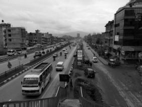
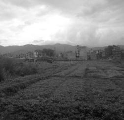
1 3. SITE ANALYSIS 3.1. INTRODUCTION According to the syllabus of design of IV/II, the department has provided us the neighborhood planning. The main purpose of this project is to expose the students to deal with various planning theories, amenities and facilities, spaces and it s linkage required for planning. It helps in implementing all the basic principles of planning thus uplifting the status of urbanscape, promoting quality of life and standards of people thus maintaining environment and promoting sustainability. Thus it helps to understand the importance of planning in contextual, national and international level SITE DESCRIPTION The site provided for neighborhood planning is located at Anantalingeshwor, Dadhikot. The site is accessible through 6-lane Araniko highway in North and Hanumante bridge to West. A new bridge is been constructed in site which is located to North of the site. Figure 1 site area We are required to plan the neighborhood for the population of 1000 families with average family member 4.7and total population of 4700 people. Thus from program formulation we have obtained the site area as ha SITE SURROUNDING The site is bounded by Hanumante river along North, East and West direction. Hanumante river has religious values and different rituals are performed in it. When we look upon the history, the settlement has started along river side, thus it is very important feature in site. The north portion of the site is developed as mixed residential and commercial zone. The west and east are developed as residential area with basic amenities while east portion is cultivable land used for farming purpose. Figure 2 site surrounding 100


2 Figure 3 site surrounding 101


3 3.4. NATURAL ENVIRONMENT CLIMATE AND TOPOGRAPHY The climate in Bhaktapur is warm and temperate. The summers here have a good deal of rainfall, while the winters have very little. The Köppen-Geiger climate classification is Cwa. In Bhaktapur, the average annual temperature is 17.9 C. About 1583 mm of precipitation falls annually. Precipitation is the lowest in November, with an average of 7 mm. Most of the precipitation here falls in July, averaging 361 mm. Figure 4 graph showing climatic condition TEMPERATURE GRAPH June is the warmest month of the year. The temperature in June averages 23.2 C. January is the coldest month, with temperatures averaging 10.1 C. Figure 5 temperature graph 102


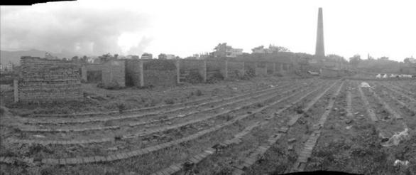
4 CLIMATE TABLE There is a difference of 388 mm of precipitation between the driest and wettest months. Throughout the year, temperatures vary by 13.1 C SITE CHARACTERISTICS LAND TOPOGRAPHY The land is cultivable land with great fertility with gentle slope towards the river bank VEGETATION Site presently is a green land with abundant plants and trees ROADS The roads in the site are not properly developed since being agricultural land. On studying the up to 3kmradius around site we have concluded that 55% roads are graveled, 25% are pitched and 20% unpitched road SEWER The sewer lines are not properly managed yet. The pipelines are connected through every households, but disposed to hanumante river which is causing pollution in the area SOLID WASTE MANAGEMENT The people manage to dispose the solid wastes in open land or burn them or dispose to hanumante river. The municipality has also provided the vehicle to collect the waste products. Figure 7 sewer mains to Hanumante river Figure 6 solid waste disposed to Hanumante river 103
5 Water supply The water is supplied through government but yet not managed. On interviewing one of the locals we came to know that the supply pipe of 9 diameter is provided in low dense population while supply pipe of 4 diameter is provided in high dense population due to which there are no managed and sufficient water supply provisions Electricity supply The electricity is supplied through Nepal Electricity Authorization (NEA) SOCIO-CULTURAL ASPECT INDUSTRY People are engaged in small scale industries like Pashupati Spanning, Tata Motors, ASB International Pvt. Ltd. Bhaktapur being famous for bricks, on of the brick factory is siyuated on our site as well TRANSPORTATION The public transportation runs through Araniko Highway as well as along hamunate bridge to Anatalingeshor municipality. The private transport also runs through the same route EDUCATION Different schools and colleges enrollment within 3km radius around the site from primary to higher studies. The school like Edden Garden English School, Sea Bird International College, Ed Design and School Uniform Center, Kathmandu Law School are situated around the site HEALTH The health facilities are been provided through health clininc to hospitals like Thimi Pharmacy, AMM Medical Hall, Diabities, Thyroid and Endocrinology, Madhyapur Hospital, Nepal-Korea Miteri Hospital, Tuberculosis Hospital OPEN SPACES Open spaces play vital role in society to uplift the social status of people. Open spaces like Thimi Kamerotar Children Park, Basipukhu Peace Park and Sallaghari Open Ground are situated in site DEMOGRAPHIC DATA For the population data, we studied the population of dadhikot area. The distribution of population is as shown in the table: Figure 8 population data of Dadhikot in year


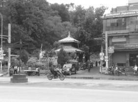
6 Population by age group: No of people Age group CULTURAL ASPECTS Hanumante river flowing through the site is considered very auspicious and various rituals are performed in it. Different temples like Narayan Mandir, Mahadev Templ, Balkumari Temple, Dakchin Barahi Temple are situated in site. Different kinds of people dwell around the city with majority newar. Major religions followed by people are Hindu, Buddhism. Figure 9 balkumari temple 4.7. ECONOMICAL ASPECT Majority of people are involved in agriculture. People are also involved in textile and garment industries, retail shops, small scale industries. 40% of people are found involved in organization. Bhaktapur is also famous for brick manufacture thus many people are involved in brick factories. Figure 10 ground floors used as retail shops Figure 11 Pashupati spanning 105
7 4.8. SWOT ANALYSIS STRENGTH Land topography of site being gentle slope is considered good for town planning. Hanumante river along the site periphery which has both religious and cultural values. Basic facilities like schools, colleges, bus stations, hospitals, banks etc available within walking distance. Easy transportation mode for both private and public access. Pleasing naturalscape with picturesque views. opportunity to incorporate traditional and modern design techniques WEAKNESS Alluvial soil in the site might not be suitable for high rising buildings. Unmanaged solid waste disposal system. No proper drainage system. Flooding in hanumante river during rainy season. The existing land owners might create issues and disputes during the planning process OPPOURTUNITY Open space along with other visual benefits. An opportunity to apply various planning principles and techniques to create a new neighborhood. Promote healthy living and built environment by following the techniques to plan a town for the future. Create a harmonious, heterogeneous and tolerant society with people from different backgrounds. As the site is linked with main road of the area, commercial activities can be flourished. Due to large vacant area, comfortable housing can be developed THREAT Encroachment of agricultural land. The agricultural soil might need special foundation designs for building which might prove costly. The present waste disposal directly into the river poses a serious problem to health. 106
8 PROGRAM FORMULATION Housing is one major part of the neighborhood planning thus requires an extensive study of the demographics of the site and its surroundings CASE STUDIES National Case Study People/hectare Average (People/hectare) Liwali Land Pooling Golphutar 190 Dallu Kuleswor 180 International Case Study Location People/hectare Average (People/hectare) Marg Swarnabhoomi Central riverfront Chennai, India 57 Cincinnati, Ohio Table: Population Density Mean Population Density: 150 person per hectare Total area PROVIDED = Ropani = ha. for Target Population, As per the population of Bhaktapur, Average member in a family is 4.7 Therefore for 1000 families, Total population = 1000 X 4.7 =
9 Age Group Study Age Group Population Above 77 Since, The demographic data shows high population of adult group, spaces supporting this group are to be provided. The educational, recreational and market spaces are to be planned as per the age group. EXISTING SERVICES Children Parks Hospitals, High School Housing, Bus stop Cinema Hall, Brick factory 108
10 REQUIRED SERVICES SELECTION Museum. Theatres, employment Hospitals, High Schools Religious, Hospital Educational services, markets Local Markets, Playground Programs formulated on the basis of Accessibility Housing Group No. of No. of people Person/ Hectare Land Area (ha) families Middle upper Class Middle Group Class Middle Lower Class Lower Class Total Table: Target Population 109


11 The Population growth Rate is 2.71% for Bhaktapur District, therefore the possible population in 10 years is 6140 and the land use may reach 27 hectare. Population In 10 years Land use In 10 years ha 27 ha A. Services Transportation Health 15% 3% 5% Parks Sports 58% 10% Primary School High School Commercial 1% 1% 2% 2% 2% 1% Administration Cultural facilities Technical Infrastructure Housing A.1. Housing 10% 10% 20% Middle Upper Group Middle Group 60% Middle lower Group Lower Group Fig: Service Distribution 110
12 SELECTION OF PROGRAM AND FORMULATION S.N. Land use Level of Services Walking Distance (km) Number 1. Transportation Road networks Health Sub Health posts, Hospitals Parks Childrens park, garden and open spaces Area per site (ha) Sports Play Field Primary School Pre primary, Kindergarten, Primary High School Colleges, Special School 1 7. Commercial Shopping Malls, Administration Government or local 9. Cultural Art, museums Facilities 10. Technical Police Station, Infrastructure Fire Stations 11. Housing Horizontal Vertical Total Hence, Proposed site area: ha Population:
13 CONCLUSION Neighbourhood planning is essential to meet the needs of its user considering size, layout, public space and location. It should understand and respond to the context and enhance its neighborhood reflecting the history and style of its neighborhood or community. Planning and implementation should be done to last which depend upon materials and technology with quality. From the researches about town planning based on various standards, case studies on national and international context we summed up to conclude how a town should be like and how is a town build and developed. Planning is done to provide guidelines and to prevent haphazard land use with settlements and misuse of open spaces. From the shape of the town, and the facilities provided in the town, all the stages are essential and require many researches to produce a better future town to meet the people s needs. We have concluded that an ideal community is the one which provides satisfactory living and is also responsive to environment. Neighbourhood planning gives communities direct power to develop a shared vision for their neighbourhood and shape the development and growth of their local area. Neighbourhood planning provides a powerful set of tools for local people to ensure that they get the right types of development for their community where the ambition of the neighbourhood is aligned with the strategic needs and priorities of the wider local area. A well designed and planned community should generate an interdisciplinary interaction between building and nature, human and buildings, human and nature and most importantly interface between human and human activities. 112
Land Use Amendment in Southwood (Ward 11) at and Elbow Drive SW, LOC
 at and Elbow Drive SW, LOC") 2018 November 15 Page 1 of 10 EXECUTIVE SUMMARY This land use amendment application was submitted by Rick Balbi Architect on 2017 August 31 on behalf of Sable Developments Ltd, and with authorization from
2018 November 15 Page 1 of 10 EXECUTIVE SUMMARY This land use amendment application was submitted by Rick Balbi Architect on 2017 August 31 on behalf of Sable Developments Ltd, and with authorization from
MAYFIELD WEST SECONDARY PLAN PHASE 2
 MAYFIELD WEST SECONDARY PLAN PHASE 2 Public Open House #3 February 25, 2010 Draft Preferred Land Use Scenario TOWN OF CALEDON PLANNING & DEVELOPMENT DEPARTMENT Open House Agenda TOWN OF CALEDON 1. Welcome
Newcourt Masterplan. November Exeter Local Development Framework
 Newcourt Masterplan November 2010 Exeter Local Development Framework Background The Exeter Core Strategy Proposed Submission sets out the vision, objectives and strategy for the development of Exeter up
WELCOME GYPSY LANE. Wider Site Location plan. Proposals for the development of LAND OFF FOXLYDIATE LANE WEBHEATH. Proposals for the development of
 WELCOME The developers are preparing an outline planning application for a residential led development and need the community s views in order to develop the proposals further WHAT IS PROPOSED? A high
Proposed Amendment to the
 Proposed Amendment to the Carrigaline Electoral Area Local Area Plan Amendment No 1: Carrigaline (T-02, O-02 & U-02) August 2012 Proposed Amendment to the Carriagline Electoral Area Local Area Plan 2011
URBAN DESIGN BRIEF NORTHVIEW FUNERAL HOME HIGHBURY AVE N, LONDON, ON
 URBAN DESIGN BRIEF NORTHVIEW FUNERAL HOME - 1490 HIGHBURY AVE N, LONDON, ON 1.1Purpose The intent of the following report is to identify an opportunity for redevelopment of two residential properties within
INTRODUCTION. Land south of Bishopswood Lane, Tadley
 0 INTRODUCTION THE SITE Introduction Gladman Developments Ltd. has successfully invested in communities throughout the UK over the past 0 years, developing high quality and sustainable residential, commercial
Pioneering the Sustainable Future of Pakistan. A New Destination of Islamabad
 Pioneering the Sustainable Future of Pakistan A New Destination of Islamabad A New Destination of Islamabad C A P I TAL S M A R T CIT Y ISL A M A B A D, PAKISTA N CAPITAL SMART CITY ISLAMABAD C A P I TAL
elbridge Core Strategy
 C elbridge Core Strategy Celbridge is designated as a Moderate Growth Town in the RPGs. The County Development Plan reinforces this designation in its settlement strategy. Moderate Growth Towns within
WELCOME. Land North of STEVENAGE. We would like to thank you for attending our public exhibition today.
 WELCOME We would like to thank you for attending our public exhibition today. The purpose of this event is to share our proposals and hear your thoughts on our ideas. Members of the project team are on
SOCIO-ECONOMIC MOVEMENT ENVIRONMENT INFRASTRUCTURE TOWN PLANNING
 Table 7: SWOT Analysis SWOT ANALYSIS SOCIO-ECONOMIC MOVEMENT ENVIRONMENT INFRASTRUCTURE TOWN PLANNING STRENGTHS HIGH COMMUTER POPULATION DENSITY MAJORITY OF POPULATION BETWEEN AGE OF 15 & 34 LARGE AVAILABLE
Final Master Plan and Development Control Regulations
 1. INTRODUCTION CHECK LIST a. Introduction b. Table of contents c. Definitions. d. scope of works. 2. FINAL OVERALL MASTER PLAN a. SITE ANALYSIS and OVERVIEW: i. Existing and Proposed Site Plan Levels.
Planning and Sustainability Statement
 Land adjacent to Manor Farm, Catterick Village Pallett Hill Sand and Gravel Co Ltd Proposed 10 new dwellings, (6 No market dwellings and 4 No affordable dwellings) with access, associated car parking and
ELK GROVE GENERAL PLAN VISION
 2-1 CHAPTER 2: 2-2 CREATING OUR The Community Vision for Elk Grove, expressed through a Vision Statement and a series of Supporting Principles, is a declaration of the kind of community that Elk Grove
Welcome to our public exhibition
 About Our Scheme Welcome to our public exhibition This exhibition gives you the chance to view and comment upon our emerging proposals for a new residential development of 68 new homes on the site of the
Improve Neighborhood Design and Reduce Non Point Source Water Pollution
 HOW TO Planning Guide Improve Neighborhood Design and Reduce Non Point Source Water Pollution This document was funded by a grant from the New Hampshire Coastal Program with funding from the National Oceanic
Elderberry Walk. Developer HAB Housing
 Case studies Elderberry Walk Developer HAB Housing Development of 161 new homes on the former Dunmail Primary School site, focused around a central green street, with retained trees, new multifunctional
Welford-on-Avon Neighbourhood Plan Consultation Event Sunday, 6 April Your name Your address
 Welford-on-Avon Neighbourhood Plan Consultation Event Sunday, 6 April 2014 Your name Your email address Please either: - complete this feedback form and put it in the box before leaving the Memorial Hall
SOUTH EAST LINCOLNSHIRE LOCAL PLAN: HOUSING PAPER DONINGTON (JUNE 2016)
") SOUTH EAST LINCOLNSHIRE LOCAL PLAN: HOUSING PAPER DONINGTON (JUNE 2016) 1 DONINGTON S PLACE IN THE SPATIAL STRATEGY 1.1 Policy 2 of the South East Lincolnshire Local Plan 2011-2036 Draft for Public Consultation
SOUTH EAST LINCOLNSHIRE LOCAL PLAN: HOUSING PAPER DONINGTON (JUNE 2016) 1 DONINGTON S PLACE IN THE SPATIAL STRATEGY 1.1 Policy 2 of the South East Lincolnshire Local Plan 2011-2036 Draft for Public Consultation
LAND USE AMENDMENT CORNERSTONE (WARD 3) 60 STREET NE AND COUNTRY HILLS BOULEVARD NE MAP 26NE BYLAW 22D2017
 60 STREET NE AND COUNTRY HILLS BOULEVARD NE MAP 26NE BYLAW 22D2017") Page 1 of 14 EXECUTIVE SUMMARY This Land Use Amendment application covers an area of 43.76 hectares ± (108.14 acres ±) located in northeast Calgary, bound by Country Hills Boulevard NE to the south and
Page 1 of 14 EXECUTIVE SUMMARY This Land Use Amendment application covers an area of 43.76 hectares ± (108.14 acres ±) located in northeast Calgary, bound by Country Hills Boulevard NE to the south and
Trafalgar Road Corridor Planning Study Open House
 Trafalgar Road Corridor Planning Study Open House June 24, 2013 6:30-8:30 p.m. Oakville & Trafalgar Rooms Overview The Livable Oakville Plan identifies the lands along Trafalgar Road, between the QEW and
1120 Haist Street - Pelham Arena Community Co-Design Recommendation Report Haist Street - Pelham Arena Community Co-Design Recommendation Report
 1120 Haist Street - Pelham Arena Community Co-Design Executive Summary: In May, 2017 the Town retained the services of The Planning Partnership to undertake a community design charrette process to determine
Sabarmati Riverfront Development Integrated Environmental Improvement and Urban Revitalization
 Sabarmati Riverfront Development Integrated Environmental Improvement and Urban Revitalization Ahmedabad and the Sabarmati Ahmedabad was established on Sabarmati in 1411 Painting: Amit Ambalal Ahmedabad
UNIVERSITY TOWN NEIGHBOURHOODS 5.5 HOUSING MELBOURNE CAMPUS MASTER PLAN 2014
 5.5 169 EXISTING CONDITIONS & VISION NEIGHBOURHOOD VISION The provision of on-campus housing into the future will continue to be an important element of the La Trobe University experience. A long-term
A VISION FOR BLAIRGOWRIE
 Welcome to the Westpark Partnership and Lidl UK GmbH Community Presentation. The purpose of this presentation is for you to view and comment upon the revised and updated proposals for the allocated development
RESOURCE PACKET River Crossing
 RESOURCE PACKE River Crossing Overall Project Focus: "River Crossing" project is funded through an NEA Our own grant that provides a comprehensive plan for public art and arts experiences that will connect
DOWNTOWN RESIDENTIAL DISTRICT DEVELOPMENT OPPORTUNITES
 DOWNTOWN RESIDENTIAL DISTRICT DEVELOPMENT OPPORTUNITES Out of all the areas in Downtown Painesville, this district provides the greatest opportunity for change with the vacation of Lake East Hospital.
9 Pershore. Introduction. Pershore Abbey
 118 Introduction 9.1 The historic town of Pershore lies on the River Avon and has a population of 7,000 (2009 Mid-Term Population Estimates). The main areas of the town are centred on the Abbey, the bustling
Development of land adjacent to Braggs Farm Lane and Rumbush Lane, Dickens Heath. Welcome. Today s exhibition. The proposal site
 Welcome Welcome to this event to discuss the development of land adjacent to Braggs Farm Lane. is currently in the preliminary stages of designing proposals to sensitively develop this site with high-quality
Parks & Landscape Services Section, Municipal Services Department
 Parks & Landscape Services Section, Municipal Services Department Proposed Development of Fernhill Park & Gardens, Stepaside, Co. Dublin with Works within the Curtilage of the Protected Structure (Fernhill
Environmental Impact Assessment Screening Report for proposed Environmental Improvement Works to the Front of Emily Square, Athy
 Environmental Impact Assessment Screening Report for proposed Environmental Improvement Works to the Front of Emily Square, Athy by CAAS Ltd for Kildare County Council July 2018 CAAS Ltd, 1 st Floor, 24-26
Story Homes. Land at Thirsk Road, Kirklevington. An Introduction to Story Homes. Our Foundations. Commitment to Consultation.
 Story Homes An Introduction to Story Homes Founded by Fred Story in 1987, Story Homes has a long and successful reputation of building high quality and high specification homes. The family owned business
1. Nantwich - Planning for a Sustainable Future
 1. Nantwich - Planning for a Sustainable Future Cheshire East Council is charged with preparing its Development Plan to guide housing and other growth over the period to 2030. The Council intends to publish
WHITELEY TOWN COUNCIL NORTH WHITELEY DEVELOPMENT SEPTEMBER 2014
 WHITELEY TOWN COUNCIL NORTH WHITELEY DEVELOPMENT SEPTEMBER 2014 Dear Resident This Special Edition of the Whiteley Voice which has been prepared in conjunction with the North Whiteley Consortium is to
PUBLIC REALM STRATEGY
 CONSULTATION DRAFT PUBLIC REALM STRATEGY Trenchard Street & Frogmore Street City Design Group Place Directorate Public Realm Strategy Trenchard Street & Frogmore Street Contents 1. Introduction 2. Understanding
MAYFIELD WEST SECONDARY PLAN PHASE 2
 MAYFIELD WEST SECONDARY PLAN PHASE 2 Council Information Workshop February 16, 2010 Draft Preferred Land Use Plan TOWN OF CALEDON PLANNING & DEVELOPMENT DEPARTMENT Workshop Agenda TOWN OF CALEDON 1. Welcome
Northern Territory Compact Urban Growth Policy
 Northern Territory Compact Urban Growth Policy A Reference Policy Document to clause 2.7 (Reference to Policy) of the NT Planning Scheme May 2015 Table of Contents 1 Policy Setting... 3 1.1 Context for
ADMINISTRATION RECOMMENDATION(S) 2018 January 25. That Calgary Planning Commission recommend APPROVAL of the proposed Land Use Amendment.
 2018 January 25. That Calgary Planning Commission recommend APPROVAL of the proposed Land Use Amendment.") Page 1 of 9 EXECUTIVE SUMMARY This land use amendment proposes to redesignate a parcel from DC Direct Control District to Multi-Residential Contextual Grade-Oriented (M-CG) District to allow for multi-residential
Page 1 of 9 EXECUTIVE SUMMARY This land use amendment proposes to redesignate a parcel from DC Direct Control District to Multi-Residential Contextual Grade-Oriented (M-CG) District to allow for multi-residential
LAND USE AMENDMENT CORNERSTONE (WARD 3) COUNTRY HILLS BOULEVARD AND STONEY TRAIL NE BYLAW 9D2017
 COUNTRY HILLS BOULEVARD AND STONEY TRAIL NE BYLAW 9D2017") Page 1 of 12 EXECUTIVE SUMMARY This Land Use Amendment application covers an area of 54.92 hectares ± (135.71 acres ±) located in northeast Calgary, bound by Country Hills Boulevard NE to the north and
Page 1 of 12 EXECUTIVE SUMMARY This Land Use Amendment application covers an area of 54.92 hectares ± (135.71 acres ±) located in northeast Calgary, bound by Country Hills Boulevard NE to the north and
Municipal Development Plan Update Urban Service Area and Hamlets
 ENCLOSURE 1 Municipal Development Plan Update Urban Service Area and Hamlets Priorities Committee January 24, 2017 MUNICIPAL DEVELOPMENT PLAN UPDATE SHAPING OUR FUTURE MDP Update - Agenda MDP Update Public
Vision 2020 Economic Redevelopment Team Final Report
 Vision 2020 Economic Redevelopment Team Final Report October 24, 2011 7/30/2011 1 2020 Visioning Redevelopment Economics Team Fritz Beiermeister Mike Evangelista Bill Largent Mark Lifter Team Members Shel
TEMPLE MEDICAL & EDUCATION DISTRICT
 City of Temple, Texas TEMPLE MEDICAL & EDUCATION DISTRICT 1 Description. The City of Temple joined in partnership with key public and private entities to jointly promote education and medical activities
GATEWAY AREA STRUCTURE PLAN
 CHESTERMERE GATEWAY AREA STRUCTURE PLAN COMMUNITY OPEN HOUSE SEPTEMBER 22 nd, 2015 PLAN AREA ± 512 hectares (± 1,265 acres) GATEWAY LOCATION UNDEVELOPED LANDS PRESENT AGRICULTURAL USE REGIONAL LAND USE
HURON COMMUNITY PLAN
 CITY OF KITCHENER DEPARTMENT OF DEVELOPMENT AND TECHNICAL SERVICES PD 94/7 HURON COMMUNITY PLAN Recommended by Planning and Economic Development Committee: October 31, 1994 Adopted by Kitchener City Council:
Wallingford Neighbourhood Plan
 Wallingford Neighbourhood Plan Introduction What is neighbourhood planning? Neighbourhood planning was introduced by the Localism Act 2011 to give local people more influence over how development comes
Former North Works, Lickey Road, Longbridge, Birmingham
 Committee Date: 14/11/2013 Application Number: 2013/06431/PA Accepted: 27/08/2013 Application Type: Full Planning Target Date: 26/11/2013 Ward: Longbridge Former North Works, Lickey Road, Longbridge, Birmingham
(Y)OUR BROOMIELAW SUMMARY DOCUMENT
OUR BROOMIELAW SUMMARY DOCUMENT") (Y)OUR BROOMIELAW SUMMARY DOCUMENT Glasgow City Centre District Regeneration Frameworks Broomielaw District August 2018 Broomielaw District Regeneration Framework as defined in Glasgow City Centre Strategy
(Y)OUR BROOMIELAW SUMMARY DOCUMENT Glasgow City Centre District Regeneration Frameworks Broomielaw District August 2018 Broomielaw District Regeneration Framework as defined in Glasgow City Centre Strategy
New Bolton Woods Cricket Club
 New Bolton Woods Cricket Club 1 1. New Bolton Woods Partnership Area What IS THIS ALL ABOUT? New Bolton Woods Ltd is a development partnership between regeneration company Urbo and Bradford Council. It
Community Assistantship Program. Milaca Downtown Revitalization
 Community Assistantship Program Milaca Downtown Revitalization Prepared in partnership with City of Milaca Prepared by Zachary Jorgensen Research Assistant University of Minnesota December, 2009 CAP Report
SITE ASSESSMENT CHECKLIST
 1. Site Details a. What is the site s name/reference? SITE ASSESSMENT CHECKLIST CR3NPWHY 3007 Gasometer Site Godstone Road CR3 0EG b. Where is the site located? Wyhteleafe; Godstone Road. Urban category1
GREENBANK DEVELOPMENT MASTERPLAN
 DEVELOPMENT MASTERPLAN POTENTIAL TRAIN STATION COMMUNITY CENTRE Greenbank will be a connected masterplanned community providing easy access to local and surrounding amenity. Affordable quality homes, green
North Oakville East Parks Facilities Distribution Plan. November, 2009
 North Oakville East November, 2009 POLICY CONTEXT 1) Purpose a) The purpose of this document is to be a guide for the location, configuration, design and development of the parks system for the North Oakville
6. REGIONAL AND COMMUNITY FACILITIES DESIGNATIONS 6.1. OBJECTIVES FOR REGIONAL AND COMMUNITY FACILITIES LAND USE DESIGNATIONS
 6. REGIONAL AND COMMUNITY FACILITIES DESIGNATIONS INTRODUCTION The Regional and land use designations provide the primary locations for uses which satisfy the health, education and other service needs
01 the vision NEW LYNN IS WAITING FOR THE GREAT LEAP FORWARD
 [A] FRAMEWORK 01 the vision 02 the framework 03 urban design principles 04 c o n t e x t 05 issues a n d o p p o r t u n i t i e s 06 creating a t.o.d. 07 key recommendations 08 seven strategic areas of
UNIVERSITY TOWN NEIGHBOURHOODS 5.2 ECO-CORRIDOR MELBOURNE CAMPUS MASTER PLAN 2014
 5.2 ECO-CORRIDOR 37 ECO-CORRIDOR EXISTING CONDITIONS & VISION NEIGHBOURHOOD VISION Investment in the Eco-corridor Neighbourhood will signify the University s commitment to supporting local ecology and
Transforming Saint John s Urban Heart -
 Transforming Saint John s Urban Heart - How Innovative Community Engagement Inspires a Bold Municipal Plan for a More Sustainable and Compact Saint John 2012 NNECAPA Conference - Brunswick, ME October
Cambie Corridor Planning Program Phase Two Draft Plan. Standing Committee on City Services and Budgets May 5, 2011
 Cambie Corridor Planning Program Phase Two Draft Plan Standing Committee on City Services and Budgets May 5, 2011 Cambie Corridor Program Terms of Reference approved July 2009 Land Use Transportation Energy
6 Growth Management Challenges and Opportunities
 6 Growth Management Challenges and Opportunities The Town has established a goal of attaining a 50% participation rate with respect to employment opportunities versus residential population. The Town s
PLANNING RATIONALE FOR 1127, 1128 MILL STREET AND 1125 CLAPP LANE CITY OF OTTAWA
 PLANNING RATIONALE FOR 1127, 1128 MILL STREET AND 1125 CLAPP LANE CITY OF OTTAWA Prepared by: Realty Initiatives and Development On behalf of the Manotick Mill Community Lands Development Corporation March
Evesham 7. Reasoned Justification
 95 Reasoned Justification 7.1 Evesham is situated within the Vale of Evesham and has an estimated population of 22,800 (2009 Mid-Term Population Estimates). As a main town it provides a wide range of services
WINCHESTER TOWN 3.1 LOCATION, CHARACTERISTICS & SETTING
 WINCHESTER TOWN 3.1 LOCATION, CHARACTERISTICS & SETTING 3.1.1 The area referred to by the City Council, as Winchester Town, consists of the Winchester Wards plus the adjoining built up areas of Badger
CHAPTER 1: INTRODUCTION
 CHAPTER 1: INTRODUCTION MAP OF OUTAGAMIE COUNTY, WI N 1 = 6 miles INTRODUCTION The Town and Village of Black Creek are located in central Outagamie County, Wisconsin. The Village is located in the north
LONGDEN VILLAGE DEVELOPMENT STATEMENT
 LONGDEN VILLAGE DEVELOPMENT STATEMENT 2017-2027 1 Longden Development Statement 2017-2027 15/01/18 1. Background 1.1 Longden Village Longden village is a very rural and traditional community first mentioned
Chapter 2: OUTLINE PLANNING APPLICATION PROPOSALS. A New Garden Neighbourhood Matford Barton 17
 Chapter 2: OUTLINE PLANNING APPLICATION PROPOSALS A New Garden Neighbourhood Matford Barton 17 2.1. SUMMARY AND STATUS OF THE PROPOSALS 2.1.1. The parameter plans and associated wording in this chapter
PREVIOUS PUBLIC PARTICIPATION BRIEF October 2014
 Comprehensive Planning During the development of the county comprehensive plan, Cultivating Community: A Plan for Union County s Future from 2007 through 2009, and three concurrent multi municipal plans
Gold Line Bus Rapid Transit Transit Oriented Development (BRTOD) Helmo Station Area Plan
 Helmo Station Area Plan") Appendix F Gold Line Bus Rapid Transit Transit Oriented Development (BRTOD) Helmo Station Area Plan Introduction and Purpose of the Plan The Gold Line Bus Rapid Transit facility is an eleven-mile dedicated
Appendix F Gold Line Bus Rapid Transit Transit Oriented Development (BRTOD) Helmo Station Area Plan Introduction and Purpose of the Plan The Gold Line Bus Rapid Transit facility is an eleven-mile dedicated
Glenbrooke North. New Westminster s Neighbourhoods Identifying Historical Contexts. Historical Neighbourhood Context Statements 2008
 Historical Neighbourhood Context Statements 2008 Glenbrooke North Fifth Street: wide boulevard, with garden median at south end 1950s subdivision character along much of Eighth Avenue and east of Fourth
Purpose of the Master Plan
 Purpose of the Master Plan 4 Master Plan Purpose The Master Plan is a policy framework for decisions that affect the physical, social and economic environment of the Town. The Parker 2035: Master Plan
Town of Peru Comprehensive Plan Executive Summary
 Town of Peru Comprehensive Plan Executive Communities that plan grow by choice, not by chance. A plan makes growth thoughtful, understandable, and predictable. A plan shows that a community is managing
APPENDIX A - Block and Draft Plan
 Built Environment - Compact Development B&D 1 Persons & Jobs per hectare Note: Each municipality defines density ranges by land use types within the Official Plan and the Secondary Plans Places to Grow
TOWN OF BRUDERHEIM Report to the capital region board
 TOWN OF BRUDERHEIM Report to the capital region board Introduction to the Town of Bruderheim Municipal Development Plan amendment and Relation to the CRB Evaluation Criteria 02 march 2017 1 Introduction
Public Participation in Urban Planning Case of Lilongwe, Malawi
 Lilongwe City Council Public Participation in Urban Planning Case of Lilongwe, Malawi PRESENTED AT THE LILONGWE INTERNATIONAL MAYORS FORUM(LIMF). 16 TH TO 18 TH May, 2018. Dr. Desmond W. Bikoko, Ph.D LILONGWE
CITY OF GAINESVILLE PARKS, RECREATION AND CULTURAL AFFAIRS DEPARTMENT VISION 2020
 CITY OF GAINESVILLE PARKS, RECREATION AND CULTURAL AFFAIRS DEPARTMENT VISION 2020 A BLUE PRINT FOR THE NEXT 20 YEARS The PRCA Vision 2020 Master Plan, adopted in November 2012, addresses the current state
Recent UN and EU Sustainable Development Policies (Post 2015): What challenges for city planning and governance
: What challenges for city planning and governance") Recent UN and EU Sustainable Development Policies (Post 2015): What challenges for city planning and governance Europe at a crossroads: the challenge for future sustainable development 20 July 2016 Roudaina
Recent UN and EU Sustainable Development Policies (Post 2015): What challenges for city planning and governance Europe at a crossroads: the challenge for future sustainable development 20 July 2016 Roudaina
Land at Fiddington Hill Nursery, Market Lavington
 Land at Fiddington Hill Nursery, Market Lavington Briefing Report for Market Lavington Parish Council Persimmon Homes (Wessex) April 2016 Background This brief report has been prepared following the Market
Draft Western District Plan
 Powered by TCPDF (www.tcpdf.org) Draft Western District Plan Submission_id: 31440 Date of Lodgment: 15 Dec 2017 Origin of Submission: Online Organisation name: Goodman Property Services Australia Pty Ltd
MOUNT AVENUE MASTERPLAN WORKING DRAFT NOVEMBER 2006
 MOUNT AVENUE MASTERPLAN WORKING DRAFT NOVEMBER 2006 1 1. OVERALL MASTERPLAN IDENTITY: Dun Dealgan motte and bailey The Dun Dealgan motte and bailey, a national monument, is located to the north east of
Westport Master Plan. Town of Westport. Master Plan Master Plan Update Committee. Westport, Massachusetts
 Town of Westport Master Plan 2004 Master Plan Update Committee Westport, Massachusetts Open Space and Recreation 5-1 Table of Contents Table of Contents... i List of Tables... ix List of Figures... ix
Master Planning: Cuba, New York Phase II. Dr. John Anderson President Alfred State College. Alfred New York
 Master Planning: Cuba, New York Phase II Dr. John Anderson President Alfred State College Alfred, New York 14802 607-587-4211 February 1, 2011 June 30, 2012 March 5, 2012 Craig R Clark, PE Dean, School
Urban Analysis. Downtown Zanesville like any city, has been physically modified through time as it
 Urban Analysis As a part of the consulting team s reconnaissance effort, an urban analysis was performed. Before the future of a place can be envisioned, one must understand the physical characteristics
MAGNETS INFRA & SERVICES LLP MAKING LIFE HAPPY
 MAGNETS LIFE INFRA & SERVICES LLP MAKING HAPPY About Magnets ENTERPRISE ASSESSMENTFounded in Hyderabad, India in the year 2017, we MAGNETS INFRA & SERVICES LLP are engaged in presenting estate, creation
The Corporation of the TOWN OF MILTON
 Report to: From: Chair & Members of the Administration & Planning Standing Committee W.F. Mann, Director of Planning and Development Date: April 16, 2012 PD 022-12 (Z19/11) Subject: Technical Report Proposed
Outline of Presentation
 LUSAKA CITY COUNCIL 2 nd Annual IGC Cities Conference Making Cities work for growth London School of Economics (LSE) United Kingdom. 28 th 29 th January 2016 Presenter: Alex Mwansa Town Clerk Lusaka City
10.0 Open Space and Public Realm
 10.0 Open Space and Public Realm 10.0 Open Space and Public Realm The Public Open Space System is comprised of: outdoor spaces available for public use that are either publicly owned (e.g., parks and
1.0 Purpose of a Secondary Plan for the Masonville Transit Village
 Report to Planning and Environment Committee To: Chair and Members Planning & Environment Committee From: John M. Fleming Managing Director, Planning and City Planner Subject: Masonville Transit Village
100 Allingham Street
 INFORMATION MEMORANDUM 100 Allingham Street KURABY CONTACT Alex Stevenson Proudly Presented by: LJ Hooker Sunnybank Hills 0421 638 618 astevenson.sunnybankhills@ljh.com.au INTRODUCTION Thank You Kuraby
INTRODUCING THE BALTIMORE CITY GREEN NETWORK VISION PLAN
 INTRODUCING THE BALTIMORE CITY GREEN NETWORK VISION PLAN GOALS OF THE GREEN NETWORK PLAN Protect and enhance the unique ecological resources of our city Support economic growth and sustainable redevelopment
Public Consultation 23 January Peel Hall, Warrington Board 1. A message from Satnam... Site history...
 Board 1 A message from Satnam... Thank you for attending today s public consultation about proposals to develop a new residential neighbourhood at. The display boards show why the development is needed
Moody Centre Station TOD Area Today
 Moody Centre Station TOD Area Today WHAT IS a transit-oriented Murray Street development area? A Transit-Oriented Development (TOD) Area is a dense, walkable residential and commercial area built to support
Prepared for the Citizens of Forsyth County by the City-County Planning Board
 Prepared for the Citizens of Forsyth County by the City-County Planning Board Bryce A. Stuart Municipal Building 100 East First Street, Winston-Salem, NC 27101 336.727.8000 www.cityofws.org/planning www.legacy2030.com
Central and East Neighbourhoods - Hermitage Outline Plan
 Central and East Neighbourhoods - Hermitage Outline Plan Office Consolidation September 2013 Prepared by: Planning and Policy Services Branch Planning and Development Department City of Edmonton The Central
CITY COUNCIL AGENDA REPORT
 CITY COUNCIL AGENDA REPORT Subject: COUNCIL MOTION LRT ALIGNMENT REMOVAL FROM THE TRANSPORTATION MASTER PLAN On February 10, 2016 Councillor Hughes provided notice in accordance with Section 23 of Procedure
4. ENVIRONMENTAL IMPACT ANALYSIS 7. LAND USE AND PLANNING
 4. ENVIRONMENTAL IMPACT ANALYSIS 7. LAND USE AND PLANNING 4.7.1 INTRODUCTION The following analysis discusses the consistency of the Proposed Project with the corresponding land use and zoning designations
Neighbourhood Planning Site Assessment Pro-forma and Guide Version 2
 Neighbourhood Planning Site Assessment Pro-forma and Guide Version 2 September 2014 Site HNP 006 Land East of Stanbridge Road and North of Lower Road 1. Background information Site location and use Site
GREEN BELTS, GREEN WEDGES OR DISPUTED GROUND
 GREEN BELTS, GREEN WEDGES OR DISPUTED GROUND John Ginivan Department of Planning and Community Development State Government of Victoria Melbourne Australia Greenbelts: Local Solutions for Global Challenges
13. London Bridge London Bridge Area Vision
 13. 13.1. Area Vision 13.1.1. is: A globally significant central London business district which is home to international business headquarters; Internationally renowned for its prominent riverfront location
URBAN DESIGN BRIEF. 2136&2148 Trafalgar Road. Town of Oakville
 URBAN DESIGN BRIEF 2136&2148 Trafalgar Road Town of Oakville Prepared By: METROPOLITAN CONSULTING INC For 2500674 Ontario Inc November 2016 TABLE OF CONTENTS Page No. 1.0 Introduction/Description of Subject
TABLE OF CONTENTS INTRODUCTION PLAN CONCEPT... 3
 TABLE OF CONTENTS BY-LAW NO. Z-1 INTRODUCTION... 1 1.0 PLAN CONCEPT... 3 1.1 Mission... 3 1.2 A Future Vision for Fredericton... 3 1.3 Growth Strategy Goals... 5 National Context... 5 Provincial Context...
Palisades Outline Plan
 NE ¼ 25 36 28 W4 Town of Penhold Approved August 13, 2012 Contents Figures & Tables... 2 Introduction... 1 Overview... 1 Purpose... 1 Development Area... 3 Ownership... 3 Topography... 3 Existing & Surrounding
CITY OF LANGLEY OFFICIAL COMMUNITY PLAN BYLAW, 2005, NO APPENDIX II - REGIONAL CONTEXT MAP
 CITY OF LANGLEY OFFICIAL COMMUNITY PLAN BYLAW, 2005, NO. 2600 APPENDIX II - REGIONAL CONTEXT MAP ± Legend Agricultural Mixed Employment Industrial Conservation & Recreation Regional City Centre Urban Containment