Part F: Three Kings Residential Design Guide
|
|
|
- Bryan Singleton
- 5 years ago
- Views:
Transcription
1 Part F: Three Kings Residential Design Guide Contents A. Background and Purpose 2 B. Context Te Tātua a Riukiuta / Three Kings 2 C. Three Kings Renewal Project Vision 3 D. Three Kings Renewal Project Components 3 E. Analysis of Opportunities and Constraints 4 1. Environment 4 2. Water 5 3. Recreation and Community Facilities 6 4. Transport, Access and Circulation 8 5. Culture and Heritage 8 6. Character and Visual Amenity 9 7. Building and Architecture 9 F. Principles of Design10 1. Environment Water Recreation and Community Facilities Transport, Access and Circulation Culture and Heritage Character and Visual Amenity Building and Architecture 20 G. Te Aranga Design Concepts 23 H. Precincts 25 Three Kings Residential Design Guide 1
2 A. Background and Purpose The Three Kings Renewal project provides a unique opportunity for the residential redevelopment of a brownfield site located close to the CBD. It achieves the objectives of the Operative District Plan (Isthmus Section), Proposed Auckland Unitary Plan (PAUP) and Auckland Plan, particularly those relating to growth, high quality development, provision of infrastructure, and avoiding, remedying or mitigating environmental effects arising from development. It will provide shared benefits including a considered response to remediating the site, as well as providing better linkages and accessibility to the open spaces and facilities in the surrounding area, making the area safer and more attractive to the community. This Design Guide has been developed as part of the Plan Change process which enables the residential development of the old Three Kings Quarry and adjoining quarried land. It derives primarily from the Master Plan Report prepared by Fletcher Residential and provided as part of their Plan Change application, as well as from the evidence of their witnesses at the Plan Change hearing. The Design Guide includes the Master Plan version 17H-1, provided at the hearing. This plan is intended to assist with an understanding of the design principles detailed in this Design Guide and is not to be read as an exact blueprint for the development of the site. This Design Guide supports the creation of a local centre and a medium to high density residential precinct which respects and enhances the best aspects of the site. The Design Guide uses the following planning and design themes: Environment; Water; Recreation and Community Facilities; Traffic; Access and Circulation; Culture and Heritage; Character and Visual Amenity; Building and Architecture. B. Context Te Tātua a Riukiuta / Three Kings Te Tātua a Riukiuta, means the belt of Riukiuta which is the Maori name given to the original grouping of volcanic cones. Three Kings the suburb was named after the three more prominent peaks and is the later name that is most commonly used today. The subject site has been extensively quarried by Winstone Aggregates, as have other smaller adjacent sites by other operators. The suburb, approximately 8km south of Auckland, is located amongst other significant volcanic peaks such as Maungawhau (Mt Eden) to the north, Maungakiekie (One Tree Hill) to the east, Owaikara (Mt Albert) to the west and Puketāpapa (Mt Roskill) to the south west. The current use of the ancestral name Te Tātua a Riukiuta, now refers to the last remaining of the five peaks at Three Kings, is part of a reserve located on the north-western boundary of the former quarry. The reserve is well used but currently has poor pedestrian and vehicular linkages from the south and the east due to the quarry land adjoining these edges. The reserve is accessible from a public car park on Duke Street, and through various pedestrian routes from Connolly Avenue, Dally Terrace, Smallfield Avenue and Fyvie Avenue from the west, and Hunters Park Drive from the east. An existing path links pedestrians from Grahame Breed Drive to the southern edge of Big King Reserve. The subject site is bounded by Big King Reserve to the north-west, commercial and industrial land to the north, existing dwellings to the west, Mt Eden Road to the east, and Grahame Breed Drive to the south. The existing Three Kings town centre and Three Kings Park are located south of Grahame Breed Drive. A Special Housing Area (SHA) will be developed in the north-eastern corner of the old quarry site. The former quarry, located at the centre of the existing Three Kings neighbourhood and amongst existing open space assets, is in an optimum location to not only provide for residential development, but also to become an extension of the town centre whilst providing new linkages to surrounding parkland. Three Kings Residential Design Guide 2
3 C. Three Kings Renewal Project Vision The Three Kings Renewal Project has the potential to be a world class community that Aucklanders are proud of, want to live in and invest in. The transformation and revitalisation of the quarry site will contribute to the restoration of the area s natural and physical infrastructure, resulting in Three Kings becoming a thriving town centre. The concept is to develop a vibrant community that is an exemplar for sustainable approaches to urban living; a community created within a highly permeable and widely connected open space network that celebrates the locality, history, cultural heritage and natural environment of Three Kings. The development will offer people a unique lifestyle choice, residential living areas on the doorstep of an existing town centre, connected to high quality recreational facilities. D. Three Kings Renewal Project Components Two co-located soccer fields The Green, will be positioned on the quarry floor and will be configured for cricket oval use during the summer season. The Green will be visually and physically connected to the existing Three Kings Oval in Three Kings Park. A public ramp together with stairs and an elevator transcend the 15 to 17 metre height differential connecting these two spaces. Public parking for the use of the ovals will be provided along Grahame Breed Drive adjacent to the Three Kings Oval and adjacent to The Green on the lower development. The Green is positioned on an open space axis that is aligned with the volcanic view shaft looking towards One Tree Hill. This axis also contains other open space facilities that provide linkages through the site and also to adjacent communities. At the Grahame Breed Drive level, there are ample opportunities to view Te Tātua a Riukiuta. In the north-western corner of the site a linear green zone will provide a buffer to the Te Tātua a Riukiuta reserve. Fundamental to the whole development is Te Tātua a Riukiuta being a protected view and landmark. A comprehensive network of cycling and pedestrian trails cross the site, link into and strengthen adjoining networks. The existing staircase on the south side of the Te Tātua a Riukiuta will be upgraded with ramps and stairway system integral with the landscape and will provide a direct connection through to The Green, Three Kings Oval and the Three Kings town centre.. Grahame Breed Drive will be slightly reconfigured to clearly identify the new civic precinct and the Three Kings town centre. An additional connection from Mt Eden Road to Te Tātua a Riukiuta on the north western edge of the former quarry is also planned This stairway connection is envisioned as a post-industrial relic that would incorporate contemporary architecture. This connection will further open up the Maunga to the communities east of Mt Eden Road. A much enhanced pedestrian and cycle trail network will run east west from Smallfield and Fyvie Avenues through the former western soccer field and The Green, providing connections to Mt Eden Road and beyond. An open plaza at the southern end of the SHA provides additional viewing opportunities of the Maunga. This plaza is to incorporate some of the industrial remnants left on the site and also to have a public elevator that connects the quarry floor to the relocated bus stop adjacent to the plaza. Public transport is embraced by the development and the pathway systems will connect with multiple bus stops. The public space on the quarry floor is flanked by a mixture of three and four level terraces providing surveillance and safety to the public realm. The building form is designed in a manner to address the civic nature of the street. Almost all car parking is rear loaded through lane ways, maximising the civic nature of streets. Rainwater gardens, swales and other water sensitive urban design features will add to the high quality streetscapes. Three Kings Residential Design Guide 3

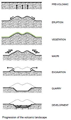
4 The Three Kings Renewal Project is intended to be a world-class exemplar development with a high regard for the public realm. All aspects of the proposal respect the cultural, historical values that make this site special. The recognition and enhancement of Te Tātua a Riukiuta through the design, land-use, additional open space and connections provide this site with a strong sense of place. E. Analysis of Opportunities and Constraints The initial phase of site analysis, undertaken as part of the Plan Change application process, involved rigorous investigation and research into the quarry and the historical volcanic landform. The analysis also examined the surrounding urban conditions of the site and the impact a redevelopment of the quarry would have on the community. It is provided here to assist in the understanding of the Design Principles which follow. Seven key themes were used to provide a framework for assessing the qualities of the site and its opportunities and constraints. These themes are: 1. Environment 2. Water 3. Recreation and Community Facilities 4. Transport, Access and Circulation 5. Culture and Heritage 6. Character and Visual Amenity 7. Building and Architecture 1. Environment Currently the site is a large quarry. At 40 metres deep at its maximum from the average surrounding grade, the relatively deep quarry is exposes a variety of ground conditions, including scoria, basalt, native bush, and rough ground which range from navigable inclines to steep cliffs. The excavation and removal of scoria from the quarry site has left a steep cut in the face of the Maunga to the east of the summit. Three Kings Residential Design Guide 4
5 Just below this face is the quarry access road used by trucks entering the site from Mt Eden Road. It runs along the north of the site turning south along the site s north-western face to enter the interior of the quarry. The un-quarried edges of the quarry are vegetated to provide screening of the quarry activity. In addition, the quarry activity and the creation of the large depression has cut off direct access to many of the open spaces around the site, including Te Tātua a Riukiuta. Through an analysis of the site it became apparent that while the suburb is rich with open spaces, there is a lack of obvious connection between these parks and reserves. This is a result of the excavation of the quarry and also of the challenging topography of the Maunga. For years access to the top of Te Tātua a Riukiuta from Mt Eden Road has been indirect and difficult for pedestrians to navigate. Opportunities and Constraints There is a benefit in utilising the existing landforms to help negotiate the grade difference from the level of Mt Eden Road to the proposed level of between RL 60-64m of the interior of the development. A series of designed architectural and landscape features will help in transitioning the average 15-17m drop in a number of ways. Terraced gardens will be employed to introduce usable green open space that can double as access routes and water treatment zones. Apartment typologies selected for their ability to traverse steep site conditions will be used along the lower part of the site. These tiered apartment buildings can be orientated to maximise sunlight as well as views towards Te Tātua a Riukiuta. Apartments of this typology can be visually perforated to maintain sight lines from the exterior of the site. These apartment buildings will be located so that the shadow they cast does not adversely affect any adjacent development at any point during the year. The almost circular nature of the site also provides the opportunity for roads that gradually slope down as they approach the lower part of the quarry. Pedestrians, bicycles, and vehicles will be able to see the site and views to Te Tātua a Riukiuta, Maungakeikei (One Tree Hill) and Maungawhau (Mt Eden) as they navigate the road network. Three Kings Quarry is sited in the middle of a fragmented network of parks and reserves. The development will act as a primary linkage to a number of sites by providing accessible routes through and around the project. A new network of pathways, stairs, a lift, boardwalks, trails, and elevated structures can provide new access from Mt Eden Road and Grahame Breed Drive through the Three Kings site up to Te Tātua a Riukiuta. 2. Water Nga mihi mo nga ahuatanga o tenei wa ki a koutou katoa, Tihei Mauri Ora! Wai (water) is a very important consideration for the local Maori and on this occasion we are dealing with the mauri (the life supporting capacity) of water, from mauri ora to mauri pakaru and back to mauri ora: the cycle in short from pristine to contaminated to pristine again. Auckland s volcanic cones hold beneath them a body of water which often flowed out of the ground at a specific location giving birth to the puna (spring). These puna have cultural significance for Maori, hence their aspirations to have this feature and cycle within the site. Mauri holds a central place in informing Maori, how and why our lives take the form they do. It imbues Maori thinking, knowledge, culture and language with a unique cultural heartbeat and rhythm. The Three Kings Quarry is situated at the top of the Meola catchment a vast and complex geology that covers approximately 38% of the Auckland isthmus before discharging at Meola Reef into the upper Waitemata Harbour. Around the quarry there are areas of high and low permeability due to the surrounding tuff and Waitemata and Tauranga rock groups. Soakage within the crater occurs either directly through exposed ground or indirectly through stormwater runoff directed to soakage via scoria or fractured basalt. Currently inflows from soakage exceed outflow by groundwater flow and dewatering takes place from a borehole on the southern boundary of the quarry, The Three Kings Three Kings Residential Design Guide 5
6 Well, which holds the water table generally at RL 34m. The abstracted groundwater is then discharged into the Auckland Councils reticulated stormwater network which discharges to the Manukau Harbour. The complex nature of the geology and water cycle and where it discharges is also very significant to Maori as there are many stories, legends and myths that tell of how they were created. The wellbeing of the mauri of the groundwater is also at the top of the priority list so a treatment train that collects, separates and removes contaminants is the preferred approach for stormwater treatment. As the Three King Quarry sits within a volcanic centre characterised by highly permeable scoria and fractured basalt, it presents an opportunity to manage stormwater flows for the site and surrounding area. The large opening in the ground funnels water from surrounding sites to the centre of the quarry where it can drain away through the high permeability scoria and fractured basalt substrate. Opportunities and Constraints There are three key considerations that require further input from the developer, Auckland Council and Tangata Whenua if the outcomes sought are to be achieved to the satisfaction of all parties. 1. The introduction of the puna mauri ora the birth place of the site s proposed water cycle. 2. The transition that will occur with the introduction of contaminants from stormwater runoff resulting in declining water quality. 3. The final stage requiring containment, separation, removal and treatment of stormwater back to mauri ora before re-entry into the ground water table completes the cycle. The aspirations of Tangata Whenua as kaitiaki are to meet the needs of future generations along with the sustainable management of the natural and physical environment. Achieving such objectives is a desirable outcome for all parties if the complexities of this proposal can be worked through collectively. The green open spaces to be provided are multifunctional, including amenity and stormwater management benefits. To achieve this a green stormwater treatment train system is proposed to commence from the north western corner with the introduction of the puna, It then meanders around the eastern inner face of the old quarry walls, reaching its re-entry back into the aquifer along the southern wall. This lineal configuration is representative of a contemporary sculpturing of Te Tātua a Riukiuta the belt. By efficiently and responsibly dealing with water on site the development will take the opportunity to recharge the aquifer with clean water. Wastewater The final wastewater disposal mechanisms for the development have not been decided. If a pumped system is used it will have an emergency overflow wastewater discharge. The location and design of such an overflow will need to be sensitive to the aspirations of the local community and iwi to minimise any potential health risks and degradation of the mana of the Maunga. 3. Recreation and Community Facilities Three Kings has a series of public open spaces including Big King Reserve, Three Kings Park, Robinson Reserve, Arthur Richards Memorial Park and Fearon Park (see Map 1). Most of these parks are well used by the community around them. However, they exist in a disjointed network where it is very difficult for residents and visitors to experience them as part of a connected whole. Three Kings Residential Design Guide 6

7 Map 1: Wider Open Space Network The location and current state of the quarry amongst these parks means that residents from the eastern side of Mt Eden Road do not have legible and accessible paths that lead them to Big King Reserve and other parks to the west of the quarry, and vice versa. Big King Reserve is currently highly frequented by strollers and dog walkers taking advantage of the existing internal footpath network. The reserve is accessible from a carpark on Duke Street, and other minor pedestrian routes. The access from Grahame Breed Drive is via a flight of stairs and footpath through uneven terrain of former quarry land. This access point has critical safety and amenity problems. Three Kings Park is very well used for active recreation by the community and local sports clubs. It is located adjacent to the Fickling Centre, Three Kings Library and Council tennis courts as part of a community activity precinct. The Fickling Centre also accommodates community group functions such as local board meetings, citizenship ceremonies and conferences. Three Kings Residential Design Guide 7
8 Opportunities and Constraints It is recognised that there is an opportunity of using the quarry as a connector that would stitch together all existing open spaces around the quarry. The most immediate opportunity is to connect Three Kings School and Three Kings Park to the south of Grahame Breed Drive to Big King Reserve across the quarry. A new linkage will be provided within the Three Kings development to allow visitors to conveniently travel between these existing open spaces, whilst enjoying new parklands and community facilities within the development. The existing topography of the quarry is a challenge to achieving such a connection. The difference in levels between Three Kings Park and the existing quarry floor means that an innovative system of stairs, ramps and public lifts will be required to provide universal access. In terms of community facilities on site, toilet and change facilities, cultural interpretation centres and parkland structures will accommodate various active and passive recreation activities. A town square adjacent to the Three Kings town centre along Grahame Breed Drive will function as a civic space, hosting communal events, markets and other spill over activities from the Fickling Centre and Three Kings Library. 4. Transport, Access and Circulation There are currently limited vehicular connections between the quarry site and the surrounding area. The principal entry to the site is from Mt Eden Road. This connects to an access road which currently transitions the approximate 40m level change to the bottom of the quarry. In order for the site to provide linkages in both and east/west and north/south axis this vertical transition will need to be addressed in a convenient and clear way. Currently visibility into the site is extremely limited due to earth embankments and plantings along Mt Eden Road and Grahame Breed Drive. This will be addressed to ensure legibility into the site is achieved in the future. The current lack of visual permeability into the site will be addressed and requires a clear way-finding strategy to assist in navigating into and through the site. The Three Kings quarry site is serviced by public bus routes on both Mt Eden Road to the east and Mt Albert Road to the south. Bus stops are located at various points along these peripheral routes. Opportunities and Constraints Key locations to enter the site are identified in the Master Plan, including a requirement for a hierarchy of entry points, streets, laneways and pedestrian trails and an additional clear entry to the site from Grahame Breed Drive the south. The quarry is a key unifying site for the surrounding area. Due to the existing network of active and passive recreational spaces adjacent to the site, there is a clear opportunity to encourage walkability and bicycle use within, through and around the development. 5. Culture and Heritage There are three historical periods to this section, prehistoric, the arrival of Maori followed by colonisation at intervals where each provides a unique layered history of Te Tātua a Riukiuta. The volcanic society provides prehistoric accounts along with some colonial history while the local Tangata Whenua provides stories, myths and legends that begin with the arrival of their ancestral waka. Three Kings Residential Design Guide 8
9 The heritage and cultural inspirations for the Master Plan design stem from a recognition of the unique history of the Te Tātua a Riukiuta. The process of shaping the Maunga followed by Maori occupation and quarrying greatly influences how the landscape within the Three Kings Master Plan is realised. Both the cultural history of Te Tātua a Riukiuta along with its industrial history of occupying and using the Maunga have informed the Master Plan. Reshaping of the edges of the Maunga reflect the connections with public open spaces. Soft, folded forms that pull the circular shapes of the Maunga into the site will help develop the language of pathways, roads, access routes, and sculptural play space throughout Three Kings. Recognising the importance of industrial artefacts, follies and even exposed quarry rock will punctuate the landscape in a way that connects the users with the rich history of the quarry. Overall, both private residents and the public will be able to read these unique forms as being inspired from a rich historical narrative as they enter and inhabit the Three Kings site. Opportunities and Constraints The site offers a wealth of opportunities to interpret the gradual development of the site from prehistoric volcanic formation, through its occupation by Maori to its industrial history as a stone quarry. Identification, interpretation and protection of heritage values are key requirements of this Design Guide. It is recognised that the Nga Mana Whenua o Tamaki Makaurau Collective Redress Bill will, when enacted, vest the ownership of 14 Maunga (volcanic cones), including Te Tātua a Riukiuta, in the trustee as defined in the Bill, and thereafter declare it a reserve and classify it as a recreation reserve. Under the Bill, Te Tātua a Riukiuta will be governed by a Maunga Authority made up of representatives of the relevant rōpū entities, Auckland Council, and a Crown representative. In keeping with this, the development in and around the quarry will need to be the subject of liaison with the iwi throughout the design and implementation process. Views to Te Tātua a Riukiuta will be used as a backdrop to the development. Views and vistas to the Maunga will be protected and enhanced to ensure strong visual links to these important historical and cultural elements. 6. Character and Visual Amenity The Three Kings Shopping Centre is currently defined as part of an emergent town centre in Auckland. As a town centre it will act as a local hub for the community, providing a wide range of retail and business services and facilities. It is expected to provide a range of living options, including mixed-use and higher-density residential options in future. The development enabled by the proposed plan change will have an urban character in response to the mix of town centre uses, with high quality streetscapes and public open spaces, augmented by appropriately scaled built form that responds to the site and its context. A range of building typologies, with a common design language will be utilised. A series of integrated but distinct neighbourhoods will be developed to respond to the varied topography on the site and surrounding land uses. Opportunities and Constraints Being the site of an old quarry, there is a significant level change between the site and the surrounding land. There are steep falls on the edges of the quarry and the level change from the existing roads to the quarry floor is approximately 40m. An opportunity exists to overcome the difficult terrain with a combination of earthworks and innovative building typologies that are dynamic and interesting. The result will be of a harmonious melding of architecture, landscape and topography. The development represents an opportunity to develop an identity for the area through a considered urban and architectural response. The site has significant views toward Te Tātua a Riukiuta and other Maunga, and there is an opportunity to create and frame these views, not only for the Three Kings Residential Design Guide 9
10 development itself, but for the wider community. The redevelopment will aim to provide visual permeability through the site and preserve important view corridors. 7. Building and Architecture The Master Plan seeks development that is consistent with the Residential 8 zoning objectives which aim to allow higher densities within growth areas in Auckland. This zoning responds to the need for smaller dwellings and a greater diversity of housing as a means to manage growth within Auckland. Analysis of both the operative District Plan and PAUP reveals an allowance of 4-6 storeys in height for development in the Three Kings area and along Mt Eden Road. The built form on the quarry site will respond to these controls, as well as taking into account local character, environment, community and housing needs. These apartment buildings have been located such that any shadow cast does not adversely affect any adjacent dwellings throughout the year. Opportunities and Constraints Opportunities exist to create a residential community comprising well designed, high quality buildings that provide high quality homes for the 21st Century. Typologies will respect the planning controls that exist on the site and relate to the landform. Being located in an emerging town centre provides an opportunity to introduce a range of suitable dwellings that address market demands as well as provide housing choice to future residents of the area. F. Principles of Design The Design Guide has been developed using a framework of seven key themes: 1. Environment 2. Water 3. Recreation and Community Facilities 4. Transport, Access and Circulation 5. Culture and Heritage 6. Character and Visual Amenity 7. Building and Architecture These themes provide the structure to address the many challenging design components of the Three Kings Renewal Project. 1. Environment The provision of high quality green spaces is a key principle in converting the site from a former quarry into a desirable neighbourhood. Principles Renewal and remediation of the topography in a sustainable and effective way Creation of a connected network of pathways linking to the surrounding public open spaces Return native vegetation to the site Connect users with cultural occupation of the Maunga Provision of a comprehensive green stormwater system for the entire site Provision of an integrated streetscape experience Provision of high-quality open spaces Creation of an open public amenity Three Kings Residential Design Guide 10
11 Strategies Create a connected network of pathways with access routes that lead to Te Tātua a Riukiuta and other public open spaces from Mt Eden and Mt Albert Roads. Use the existing quarry access route as a Bush Road that shapes the northern end of the site. Establish a green stormwater infrastructure ring within interior of the site to treat and hold stormwater runoff in open and planted wetlands or raingardens before it recharges the aquifer. Use found language of earth-forming from around the site to navigate sloping open spaces. Provide spaces that can be used for football, cricket and other sports, as well as more open and free play Connect Three Kings Park with a Town Square feature that cascades into the interior of the site. Design streetscapes that integrate walking paths, low planting, tree planting, on-street car parking, and entrances to apartments. Create a series of footpath typologies that will be used in order to traverse the varying grades around the site, ranging from accessible paths, to lifts, stairways, and elevated ramps. 2. Water Dealing with water in a responsible fashion is integral in the realisation of the Three Kings Renewal Design Guide. The site of the old quarry is linked to a much larger water network, namely the fresh water aquifer sitting directly underneath the site. The drainage systems that will be implemented will be chosen for their strengths in treating and directing rain water, stormwater holding, filtration and overall public amenity. Principles Fill existing quarry to above the natural ground water level Provide on-site water treatment and catchment systems Ensure that water travelling back into the aquifer is clean and moves in a controlled manner Provide water features as public amenity Utilise water resources for irrigation to provide for a robust and sustainable vegetative network. Strategies Build integrated rain garden systems into streetscapes Create a green stormwater infrastructure ring that wraps the interior of the site and treats and holds the majority of overflow stormwater runoff prior to filtration through the scoria layer and into the aquifer Design the green stormwater infrastructure ring in a way that provides open to air wetlands or raingardens that connect the public back to the water system Establish networked and controlled irrigation to key vegetated areas. Provide for use of water for amenity and plants Three Kings Residential Design Guide 11

12 Three Kings Residential Design Guide 12

13 3. Recreation and Community Facilities The development should contain a mixture of recreational spaces and community facilities to serve the needs of residents and the wider community. A mixture of active playing fields, walking and cycling paths will be provided. Other community facilities will be provided, in consultation with Mana whenua. Principles Ensure all spaces are flexible to suit a broad range of user groups locally and Auckland-wide Identify areas for active and passive recreation Integrate community and cultural activity Balance recreation with ecological integrity Ensure active recreation areas are designed to operate at efficient levels of use Ensure Mana whenua involvement in the development of recreation and community facilities Strategies Allocate spaces for passive recreation Allocate spaces for active recreation Provide toilet and changing facilities near active playing fields Create a connected network of pathways and access routes that link proposed recreational spaces with the existing open space network Designate a town square area for community gatherings and events Create the opportunity for education, cultural and community support opportunities through information billboards and reference points Ensure ongoing Mana whenua involvement with the development of the Whare Manaaki and adjoining public open spaces Three Kings Residential Design Guide 13

14 4. Transport, Access and Circulation Convenience in getting to, and through the site is key to ensuring that the former quarry becomes usable and developable land. The former quarry site, having been disconnected from the surrounding neighbourhood in the past, will need clear and legible way finding strategies to enable residents and the community to use the facilities proposed and to access the greater network of recreational spaces. The hierarchy of streets, laneways and pedestrian trails provided will create an accessible and permeable urban infill development. Principles Encourage the use of existing and proposed public transport networks Provide universal access to and through the site Provide adequate opportunity for visitor parking Establish clear entries to the development Establish a hierarchy of streets, laneways and pedestrian trails Strategies Create clear entries to the site from Mt Eden Road and Grahame Breed Drive Provide accessible pedestrian and bicycle connections to public transport nodes on Mt Eden Road and Mt Albert Road Encourage walkability and bicycle use through the provision of pedestrian and bicycle trails throughout the site and beyond, including to the Puketāpapa Greenways. Trails should also connect to existing open space networks to enable a larger community uptake and use of proposed facilities within the development Provide a mixture of stairs, ramps and a public lift to enable residents and the community to navigate the difference in levels on site Provide on-street visitor parking on all main streets to accommodate visitor demand and overflow during large sports and community events Provide a signalised pedestrian crossing at the intersection of Mt Eden Road and Grahame Breed Drive to provide a safe pedestrian connection into the development and Three Kings town centre from the eastern side of Mt Eden Road and the school Retain and enhance existing pedestrian trails to Big King Reserve along the western boundary of the development Provide lift access to the town centre, community facilities and public transport for all of the multistorey cascading apartments Three Kings Residential Design Guide 14

15 Three Kings Residential Design Guide 15
16 5. Culture and Heritage The site of the old quarry at Three Kings is an historically and culturally important site, not only to Auckland, but to the surrounding region. The area was once home to five large volcanic cones, all of which were over 100m high and formed a prominent part of the landscape. These cones were also important sites to local iwi. In the 19th and 20th century, the area was extensively quarried for scoria and basalt rock and today, only Te Tātua a Riukiuta, at 133m, remains. It is an important park serving the local community. The historical context of the site, its change of use through time, and the importance of Te Tātua a Riukiuta as a prominent historical and landscape feature will continue to inform the design of the development. All development will tell the story of the historical layers that exist at Three Kings and will be designed in consultation with Mana whenua. Principles Provide reference to the history of the original volcanic forms, Maori occupation and the quarry site, through design within the development, both architectural and landscape elements Show the layered history of use and development through interpretation Retain and enhance heritage items and heritage landscapes Create a visual and physical connection between the site and Te Tātua a Riukiuta Strategies Provide visual and physical links to Te Tātua a Riukiuta and surrounding volcanic peaks Reinforce the historical and geological links between the site, Te Tātua a Riukiuta and the surrounding volcanic peaks and public domains by connecting them through a series of pedestrian paths, stairs, lifts and platforms The principle of Tohu* is applied and respected through the view opportunities towards Te Tātua a Riukiuta throughout the development. Public spaces, such as The Green and the Town Square, will maintain generous view corridors towards the Maunga through the use of built form as framing elements Show the layered history of the site through interpretation Lightweight industrial structures evocative of machinery used during past quarry operations will ramp up to a series of platforms before tying into the Maunga access path that will originate on the south western edge of the site Reshaping of the edges of the quarry recalls historical Maori earthworks. Soft, folded landscape forms that pull the circular shapes of the Maunga into the site will inform the language of pathways, roads, access routes, and sculptural play space throughout the Three Kings Renewal Project area Acknowledge local heritage by referencing traditional built forms such as pa and terracing that once existed in the area, in dealing with the topography of the site Retain and enhance heritage items and heritage landscapes Important industrial artefacts, follies and exposed quarry rock will punctuate the landscape in a way that connects both locals and visitors with the rich history of the quarry. Maintain and display these forms through public installations to enable both private residents and the public to read these unique forms as being inspired from a rich historical narrative as they enter and inhabit the Three Kings site. * Tohu - a sign, mark, landmark or distinguishing feature Three Kings Residential Design Guide 16

17 Three Kings Residential Design Guide 17
18 6. Character and Visual Amenity The character of the site is defined by the response to the historical and physical context in making places to live, work, shop and socialise. The aim of the Design Guide is to ensure the urban character developed through built form, planting and the incorporation of surrounding land uses into the redevelopment, makes special places and creates distinct but integrated neighbourhoods in the development. Special places, such as The Green and the Town Square will respond to the need for a backdrop to public life and to the need to reinforce connections to the surrounding community and places. The distinct neighbourhood and built forms will be a direct response to the topography of the site. Visual permeability will be provided through the site and views to Te Tātua a Riukiuta will be framed and protected. Principles Utilise views to Te Tātua a Riukiuta as a backdrop to the development and the wider community. Enhance the urban village character of the redevelopment by creating distinct but integrated neighbourhoods Utilise topography to maximise views and vistas. Ensure visual links to the Maunga are protected and enhanced Create attractive and cohesive streetscapes and public domain Enhance the urban character of the development Strategies Utilise views to Te Tātua a Riukiuta as a backdrop to the development, and protect visual links to the Maunga. Residential block layouts and key access roads will be orientated to maximise views towards the Maunga. Aspect and view linkages to the Maunga will be maximised for both the development and for Three Kings suburb through careful alignments of building blocks and streets. A high level of public pedestrian permeability is provided through the apartment blocks. Built forms will be used in public spaces, such as The Green and the Town Square, as framing elements to the Maunga view shaft. Planting and streetscapes Pohutakawa and other native plants will be used to line the new roadway at the northern entry to the site to create an experience of travelling through thick New Zealand vegetation. Within the Riu Precinct, high-quality streetscapes and rain gardens will be integrated with medium density apartments and access paths. Street trees used throughout the rest of the site will be planted along typical road edges and will define the spacing of street parking that will be coupled with the hardscape strategy. Green stormwater infrastructure zones will comprise grasses, reeds, native ferns, wetlands and raingardens. Access through these zones will be created by a series of timber boardwalks that meander through tall reeds. Utilise topography to maximise views and vistas Cascading apartments against the quarry edge will maximise outlook and open views towards Maunga from the quarry floor. Enhance the urban character of the redevelopment Respond to the site s urban context and integrate surrounding land uses into the redevelopment, such as commercial/retail activities in the Town Square, community and sporting use in The Green and residential use throughout the development. Three Kings Residential Design Guide 18

19 Map 2: Sightlines Three Kings Residential Design Guide 19
20 7. Building and Architecture The built form that is proposed is heavily influenced by the context, acknowledging the site s topography, the connection to Te Tātua a Riukiuta and the need to preserve important views and vista as well as the need to provide a frame for public spaces and active streets. Mt Eden Road and Grahame Breed Drive are particularly important, as buildings fronting these streets will be the most visible aspects of the new development, and become the face of the wider Master Plan area. The two roads have a very different character and buildings will respond to and enhance this. The architecture will respond to the built form in the surrounding area, providing a well thought out urban response. The architecture will create a sense of place that ties together the whole development, as well as giving a distinct character to each of the 6 precincts identified in the Master Plan. Principles Introduce building typologies that respect and relate to the landform Provide a consistent design language that creates architectural and visual interest for a range of uses Provide attractive streetscapes and public spaces Create high quality, sustainable homes Bulk and scale of buildings is to respond to site topography, to be appropriate for the proposed use and to form distinct neighbourhoods Strategies Introduce typologies that respect and relate to the landform Apartments are proposed to be built against the existing quarry face. These buildings are designed to take advantage of the height difference between the existing surrounding roads and the proposed final level of the quarry floor, which will be elevated with filling to a level approximately 15m - 17m below surrounding streets. This typology is designed to maximise the potential of the quarried landform by hiding service and car park spaces against the slope, and achieving residential units on two faces with minimal excavation Building typologies such as terraces and cascading apartments will be selected for their ability to traverse steep site conditions Apartment buildings will be located such that the shadow cast does not adversely affect any adjacent dwellings throughout the year Consistent design language The built form will be contemporary in design and materiality, reflecting the needs of today s urban lifestyle and modern construction methods A common design language is required to provide coherence to a variety of built form responses and diversity at the scales of the site, street and block A consistent design language will ensure that buildings are designed to a common vision that enhances the existing and future desired built form and character of the neighbourhood Sense of Place While there will be a consistent design language to tie the whole development together, there will be a distinct architectural expression and built form to provide each of the precincts identified in the Master Plan a distinct sense of place The Town Square a civic space working to complement the functions of the Fickling Centre, Three Kings Library and retail uses on Mt Albert Road. The Town Square will have a mixture of open to air and under croft areas that accommodate communal and civic functions. The square, will have a northern aspect and positive outlook towards to the Maunga, and will be designed to act as a northern extension of the town centre The Green - comprises two sports fields, surrounding parkland and part of the green stormwater infrastructure on the valley floor in the southern part of the site. The Green will be the primary outdoor recreation space for residents in the development and the wider Three Kings community. The sports fields will be able to accommodate cricket in the summer and soccer in the winter, as well as informal recreation when not in use by these sports. The Three Kings Residential Design Guide 20
21 Green will have links to the existing Three Kings Reserve and will be easily accessible to the Three Kings School Western Terraces a folded landscape element in the western part of the site that negotiates the level change from the terrace form housing to the sports fields on the valley floor. The Western Terraces will comprise a sculptural and horizontal landscape feature, with pedestrian pathways and also provide stormwater retention functions The Hilltop (Winstone Precinct) this area, which will be developed as a SHA, comprises low rise apartment buildings is in the north-eastern part of the site, at Mt Eden Road level. It is characterised by a pedestrian entry plaza from Mt Eden Road and strong western view corridors towards the Maunga The Bush Precinct, in the north-western part of the site. The character of this area of apartment buildings comes from proximity to the Maunga, and the buildings are designed to maximise views to the Maunga behind The Riu Precinct, comprising terraced housing and low rise apartments on the valley floor, north of the Green. The dwellings will be integrated with high quality streetscapes and access paths, with the green stormwater infrastructure incorporating planting and boardwalks around the perimeter Provide attractive streetscapes and public spaces Bulk and scale of the built form and the edge treatment will consider the activation of streets and public spaces Promote built form and open space for safety and surveillance Create high quality, sustainable homes The proposed built form incorporates good passive thermal design principles including solar access, orientation and cross ventilation Maximise views and outlooks from the apartments Mt Eden Road frontage The experience of the street edge is primarily one of residential buildings set back from a tree lined and landscaped boulevard with setbacks deep enough to allow the growth of substantial mature trees The ground floor is specifically designed to overlook and activate the street edge, while providing some element of privacy for the occupants. The ground floor level can be raised slightly above Mt Eden Road to help provide privacy, but this should be by under 1m so handrails are not required Significant breaks will be provided between the buildings wide enough to allow a full appreciation of the view over the Riu, and of the Maunga The top floor is set back to reduce the mass of the building when viewed from street level. This should be at least 2m to any projection, including the edge of any roof, to create a clear setback from the floor below Grahame Breed Drive The section overlooking the Three Kings Park will respond to the openness of the park and the existing mature trees, by applying a similar design approach to Mt Eden Road. The design of the two streets will be considered together so the development turns the corner and draws pedestrians into the town centre The parts of Graeme Breed Drive directly to the north of the town centre will be designed as a retail or commercial edge to complement the existing commercial centre. In the area identified as having active uses at ground floor, the buildings will be built up to the street, be at grade, and include verandahs to provide weather protection to pedestrians Any building edge next to the public plaza or staircase will be carefully designed to overlook this space The Town Square The town square is a publicly accessible open space which is located at street level on top of one of the cascading apartments. It will include active uses such as a café or restaurant with apartments above The square will be designed to maximise the view of the Maunga from the existing town centre, complement and overlook the adjacent grand stair and open space, and provide a large, high amenity open space with views of the Maunga. Three Kings Residential Design Guide 21

 Three Kings Residential")
22 Small scale retail Residential Mt Eden Road/ Grahame Breed Drive Parking Small scale retail Quarry Floor ( Riu ) Three Kings Residential Design Guide 22
23 G. Te Aranga Design Concepts 1. Mana/Rangatiratanga/Kaitiakitanga The early and ongoing engagement with Mana whenua during the development of the Plan Change application is commended. These relationships are to be maintained through formalised kaitiaki roles through the detailed design and construction phases and beyond into the ongoing management of communal areas, green stormwater infrastructure and path networks. Opportunities include: Continue to work with Mana whenua to formalise a working relationship for the detailed design phase. Consider the formation of a Rōpu kaitiaki to maintain an ongoing kaitiaki relationship between the development and neighbouring reserve areas. This could be done through the Tāmaki Collective. 2. Whakapapa/Naming Reviving ancestral Māori names enhances the mana of both those ancestors and their descendants who are the Mana whenua of today. With so much destruction of pā and kāinga sites in the past, it is particularly important to find ways to remember and honour names associated with these significant sites. In particular, appropriate acknowledgement of the four other local maunga that have been lost through quarrying functions is appropriate. Opportunities include: Mana whenua individually and collectively volunteer names and cultural narratives for potential naming of features, lanes, path networks and communal areas. 3. Oranga The principle of Oranga pertains to holistic wellness or health and can be applied to both environmental and physical health. Utilising the proposed vehicular and path networks, walking / running tracks can be developed to promote healthy physical activity, such as loop routes that allow for all levels of fitness from a 1km evening stroll to a 10 lap jogging circuit. Opportunities include: Develop a 1km walking track around the housing development and reserve to promote both physical fitness and connectivity between residents, neighbours and kaitiaki Incorporate individual raised bed food gardens (ideally using stone walling). Incorporate communal gardening areas using local stormwater for watering purposes Incorporate water cress patches where storm water quality allows 4. Tohu The view shafts identified in Diagram F08-85(c) acknowledge the key maunga of Te Tātua a Riukiuta, Maungawhau and Maungakiekie. Additional opportunities include: Remembering the four other local maunga that have been quarried away. Their former summit locations are to be plotted and where possible these points marked and named within the landscape. Interpretation panels could also be used to provide more information on these former pa / kāinga sites. Although it is noted that the residential development will be created at a lower level than the surrounding neighbourhood there is a correlation between this approach and the sheltered crater living environments that mana whenua enjoyed on the isthmus prior to and after European settlement. Three Kings Residential Design Guide 23
24 5. Taiao Mana whenua will have the opportunity to identify a range of specific native plant species that have particular significance to the area, through reference to local cultural narratives, including weaving species and medicinal plantings. Opportunities include: From volunteered local Mana whenua narratives develop a native plant inventory to draw from when developing detailed landscape design and planting plans. With such high quality water available on site, it may be possible to include watercress as part of a mahinga kai area within part of a wetland 6. Mauri tū The approach to stormwater and groundwater management will be via the tātua green stormwater infrastructure network. Other opportunities to enhance the mauri of land / soil water and materials selections include: Ensuring any excavated material is carefully reused on site, possibly as a source of building / aggregate / landscape fill material Ensuring any imported fill material is carefully sourced to adverse adverse ground contamination. Waiora the opportunity to separate out a location for waiora (highest purity ground water) to be kept pure and able to be accessed by residents and mana whenua for a range of functions Ensuring roof materials are chosen to minimise heavy metal runoff into the stormwater system Use of locally sourced scoria and basalt rock as building / landscaping materials with a known appropriate local mauri as well as a reference to the quarrying operations on the wider site 7. Mahi toi Significant opportunities for the inventory of ancestral names and cultural narratives to inform design responses to landscape, urban design and architecture will be maximised. Opportunities include: Use of Mana whenua nominated artists for sculptural installations Use of stone walls in landscape and architecture as an ancient and unique feature of Te Tātua a Riukiuta. Research and replicate the particular stone wall building technique and aesthetic for appropriate application within the residential area Explore opportunities to remember Te Toka Tūwhenua with imagery / sculpture possibly associated with the green stormwater infrastructure or reserve area 8. Ahi kā The Three Kings development offers a significant opportunity for mana whenua to rekindle their fires and connect meaningfully with the residential and adjacent reserve areas. Opportunities include: Development of the Whare Manaaki from which Kaitiaki and manaakitanga roles can be carried out Mana whenua to make commercial investments in the development Mana whenua to make commercial investment in social housing Three Kings Residential Design Guide 24
 5. The Bush Precinct 6.")
25 H. Precincts Key to Precincts 1. Town Square 2. The Green 3. Western Terraces 4. Hilltop (Winstone Precinct) 5. The Bush Precinct 6. The Riu Precinct Three Kings Residential Design Guide 25
Three Kings Residential Design Guide
 Three Kings Residential Design Guide Contents A. Background and Purpose... 2 B. Context Te Tātua a Riukiuta / Three Kings... 2 C. Three Kings Renewal Project Vision... 3 D. Three Kings Renewal Project
THREE KINGS RENEWAL DESCRIPTION OF URBAN DESIGN / ARCHITECTURAL ELEMENTS AND PROCESS. prepared by dko Architecture
 THREE KINGS RENEWAL DESCRIPTION OF URBAN DESIGN / ARCHITECTURAL ELEMENTS AND PROCESS prepared by dko Architecture THESE PLANS OUTLINE THE VISION OF FLETCHER RESIDENTIAL LTD AND ARE NOT ENDORSED BY AUCKLAND
THREE KINGS RENEWAL MASTER PLAN REPORT. Final H-2
 THREE KINGS RENEWAL MASTER PLAN REPORT Final 01.08.2014 15H-2 1.0 EXECUTIVE SUMMARY 4.0 analysis 6.0 Master plan Study Area Master plan Objectives Background and Purpose Master plan Structure Process Principles
THREE KINGS RENEWAL MASTER PLAN REPORT H-1
 THREE KINGS RENEWAL MASTER PLAN REPORT 02.09.2014 15H-1 THESE PLANS OUTLINE THE VISION OF FLETCHER RESIDENTIAL LTD AND ARE NOT ENDORSED BY AUCKLAND COUNCIL 1.0 EXECUTIVE SUMMARY 4.0 analysis 6.0 Master
I333 Three Kings Precinct
 I333. Three Kings I333.1. Precinct description The Three Kings Precinct provides for the development of a vibrant, sustainable urban village on the former quarries and the adjacent land at Three Kings.
Three Kings Private Plan Change Request 15-H1
 Three Kings Private Plan Change Request 15-H1 31 August 2014 TABLE OF CONTENTS 1.0 INTRODUCTION... 4 2.0 OVERVIEW... 5 3.0 LAND SUBJECT TO THIS PRIVATE PLAN CHANGE REQUEST... 8 4.0 CURRENT USE... 11 5.0
I539. Smales 2 Precinct
 I539. Smales 2 Precinct I539.1. Precinct Description The Smales 2 Precinct applies to a 4.8 hectare block of land located on the southern side of Northcote Road and fronting Lake Pupuke, Takapuna. The
I615. Westgate Precinct
 I615. Westgate Precinct I615.1. Precinct Description The Westgate Precinct is located approximately 18km west of the Auckland city centre. There are seven Sub-precincts in the Westgate Precinct: Sub-precinct
Auckland City Operative District Plan (Isthmus 1999) Private Plan Change: Three Kings Precinct PA372
 Private Plan Change: Three Kings Precinct PA372") Auckland City Operative District Plan (Isthmus 1999) Private Plan Change: Three Kings Precinct Under Part 2 of Schedule 1 of the Resource Management Act 1991 PA372 1 2 3 Part C: Insert the following in
Auckland City Operative District Plan (Isthmus 1999) Private Plan Change: Three Kings Precinct Under Part 2 of Schedule 1 of the Resource Management Act 1991 PA372 1 2 3 Part C: Insert the following in
H7 Open Space zones. (a) provide for the needs of the wider community as well as the needs of the community in which they are located;
 provide for the needs of the wider community as well as the needs of the community in which they are located;") H7. Open Space zones H7.1. Background The majority of land zoned as open space is vested in the Council or is owned by the Crown. However some areas zoned open space are privately owned. While the open
H7. Open Space zones H7.1. Background The majority of land zoned as open space is vested in the Council or is owned by the Crown. However some areas zoned open space are privately owned. While the open
REMARKABLES PARK ZONE
 .10 Remarkables Park Zone.10.1 Resources, Activities and Values The Remarkables Park Area comprises approximately 150 hectares of perimeter urban land in the vicinity of Frankton and occupies a strategic
Chapter 5 Urban Design and Public Realm
 5.1 Introduction Public realm is all areas of the urban fabric to which the public have access. It is where physical interaction takes place between people. It therefore, includes buildings and their design,
Woodbrook - Shanganagh
 Section 4: Key Sites Framework Strategy Woodbrook - Shanganagh Local Area Plan 2017-2023 4. Site Framework Strategies The Master Plans shall have regard to the thematic objectives under the LAP Development
Tāhuhu whakaruruhau ā-taone The sheltering ridge pole
 B2. Tāhuhu whakaruruhau ā-taone - Urban growth and form B2.1. Issues Tāhuhu whakaruruhau ā-taone The sheltering ridge pole Auckland s growing population increases demand for housing, employment, business,
The Proposed Auckland Unitary Plan (notified 30 September 2013)
") 3 Business zones Introduction There are 10 business zones in the Unitary Plan: City Centre Metropolitan Centre Town Centre Local Centre Neighbourhood Centre Mixed Use General Business Business Park Light
3 Business zones Introduction There are 10 business zones in the Unitary Plan: City Centre Metropolitan Centre Town Centre Local Centre Neighbourhood Centre Mixed Use General Business Business Park Light
Three Kings Private Plan Change Request 15-H2
 Three Kings Private Plan Change Request 15-H2 31 August 2014 TABLE OF CONTENTS 1.0 INTRODUCTION... 3 2.0 OVERVIEW 4 3.0 LAND SUBJECT TO THIS PRIVATE PLAN CHANGE REQUEST... 6 4.0 CURRENT USE 8 5.0 FLETCHER
Chapter 2: OUTLINE PLANNING APPLICATION PROPOSALS. A New Garden Neighbourhood Matford Barton 17
 Chapter 2: OUTLINE PLANNING APPLICATION PROPOSALS A New Garden Neighbourhood Matford Barton 17 2.1. SUMMARY AND STATUS OF THE PROPOSALS 2.1.1. The parameter plans and associated wording in this chapter
Next Steps / Development Process. Structure Plan. June submitted to City of Fremantle. Structure Plan. July supported for advertising
 overview What is today about? In July 0, the City of Fremantle resolved that the be advertised for public comment. Today is about: Understanding the history and context of the site Having your say on the
Three Kings Precinct. Plan Change 11 to Auckland Unitary Plan Operative in Part Section 32 Report
 Three Kings Precinct Plan Change 11 to Auckland Unitary Plan Operative in Part Section 32 Report Updated 12 February 2018 2 TABLE OF CONTENTS 1.0 EXECUTIVE SUMMARY... 4 2.0 CONTEXT AND HISTORY OF THE THREE
Appendix 1 Structure plan guidelines
 Appendix 1 Structure plan guidelines This appendix forms part of the regional policy statement [rps]. 1.1. Introduction Structure plans are an important method for establishing the pattern of land use
B4. Te tiaki taonga tuku iho - Natural heritage
 B4. Te tiaki taonga tuku iho - Natural heritage Tuia I runga, tuia i raro, tuia ki te waonui a Tiriwa Bind the life forces of heaven and earth to the great realm of Tiriwa B4.1. Issues Auckland s distinctive
8.0 Design and Form of Development 43/
 42/ 8.0 Design and Form of Development 43/ Rothwells Farm, Golborne/ Development Statement Figure 7. Site Constraints Key 44/ Site Boundary 360 Bus Route/Stops Existing Trees Underground Water Pipe Sensitive
4 RESIDENTIAL ZONE. 4.1 Background
 4 RESIDENTIAL ZONE 4.1 Background The residential areas within the City are characterised by mainly lowrise dwellings sited on individual allotments. Past architectural styles, settlement patterns and
North Oakville East Parks Facilities Distribution Plan. November, 2009
 North Oakville East November, 2009 POLICY CONTEXT 1) Purpose a) The purpose of this document is to be a guide for the location, configuration, design and development of the parks system for the North Oakville
New-Cast Mixed-use Development Proposal King Street West, Newcastle, Ontario
 URBAN DESIGN BRIEF New-Cast Mixed-use Development Proposal King Street West, Newcastle, Ontario TABLE OF CONTENTS: 1.0 Executive Summary 2.0 Creating Vibrant and Sustainable Urban Places: Excerpts from
WELLINGTON HOSPITAL DESIGN GUIDE TABLE OF CONTENTS
 WELLINGTON HOSPITAL DESIGN GUIDE TABLE OF CONTENTS 1.0 Introduction Page 2 The Place of Wellington Hospital 2 The Future of the Hospital 2 2.0 The Intention of the Design Guide 3 3.0 Analysis 4 General
QUEENSTOWN LAKES DISTRICT COUNCIL SUBDIVISION DESIGN GUIDELINES
 Attachment C: Draft QLDC Subdivision Design Guidelines QUEENSTOWN LAKES DISTRICT COUNCIL DESIGN GUIDELINES A DESIGN GUIDE FOR AND DEVELOPMENT IN THE URBAN ZONES QUEENSTOWN OFFICE 10 Gorge Road Queenstown
97 Lea Bridge Road, Leyton, E10 7QL London Borough of Waltham Forest December 2015
 97 Lea Bridge Road, Leyton, E10 7QL London Borough of Waltham Forest December 2015 Public Realm and Landscape Proposals LEA BRIDGE ROAD, WALTHAMSTOW Public Realm & Landscape Proposals BDP(90)RPT001 December
Section Three, Appendix 16C Medium Density Housing, Design Assessment Criteria (Residential 8A zone)
") APPENDIX 16C MEDIUM DENSITY HOUSING, DESIGN ASSESSMENT CRITERIA (RESIDENTIAL 8A ZONE) PURPOSE OF APPENDIX 16C (RESIDENTIAL 8A ZONE) In the Residential 8A Zone the following are defined as restricted discretionary
APPENDIX 16C MEDIUM DENSITY HOUSING, DESIGN ASSESSMENT CRITERIA (RESIDENTIAL 8A ZONE) PURPOSE OF APPENDIX 16C (RESIDENTIAL 8A ZONE) In the Residential 8A Zone the following are defined as restricted discretionary
GREENBANK DEVELOPMENT MASTERPLAN
 DEVELOPMENT MASTERPLAN POTENTIAL TRAIN STATION COMMUNITY CENTRE Greenbank will be a connected masterplanned community providing easy access to local and surrounding amenity. Affordable quality homes, green
Keystone Business Park Precinct Structure Plan North East Industrial Precinct. Part 2 Design Principles
 Keystone Business Park Precinct Structure Plan North East Industrial Precinct Part 2 Design Principles Context Issues Services Landform Issues Geotech and contamination Ecology Traffic and access Issues
Page 1 of 19 URBAN DESIGN FRAMEWORK FOR BOLTON STREET WATERFORD
 Page 1 of 19 URBAN DESIGN FRAMEWORK FOR BOLTON STREET WATERFORD 1.0 Introduction: The relocation of the City Council stores and depot from Bolton Street creates an exciting opportunity for development
I207. Learning Precinct
 I207. Learning Precinct I207.1. Precinct description The Learning Precinct is centred on the Symonds Street ridge where the University of Auckland and Auckland University of Technology have the majority
Urban Design Guidelines
 Urban Design Guidelines These Urban Design Guidelines comprise the Key Design Objectives below, the Roads Design Guidelines overleaf and Neighbourhood Framework Plans. Together with Section 3: Urban Design
Plan Modification to Chapter B2 of the Auckland Unitary Plan(AUP) Operative in part (15 November 2016)
 Operative in part (15 November 2016)") UNITARY PLAN UPDATE REQUEST MEMORANDUM TO FROM Phill Reid Linley Wilkinson DATE 25 September 2018 SUBJECT Plan Modification to Chapter B2 of the Auckland Unitary Plan(AUP) Operative in part (15 November
UNITARY PLAN UPDATE REQUEST MEMORANDUM TO FROM Phill Reid Linley Wilkinson DATE 25 September 2018 SUBJECT Plan Modification to Chapter B2 of the Auckland Unitary Plan(AUP) Operative in part (15 November
Ensure that development within the Arrowtown Urban Growth Boundary provides:
 URBAN DEVELOPMENT 4 4.2.5.2 Ensure that development within the Arrowtown Urban Growth Boundary provides: an urban form that is sympathetic to the character of Arrowtown, including its scale, density, layout
Memorial Business Park Site. Proposed Future Development. Design guidelines. August
 Memorial Business Park Site Proposed Future Development Design guidelines August 2014 www.designenvironment.co.nz 0064 3 358 3040 Contents 1.0 Background 1.1 Introduction 3 1.2 Objectives 4 2.0 Context
The Proposed Auckland Unitary Plan (notified 30 September 2013)
") 8 Special Purpose zones 8.1 Airport zone The Airport zone applies to the Kaipara Flats Airfield, North Shore Airfield, Auckland International Airport and Ardmore Airport. Auckland International Airport
8 Special Purpose zones 8.1 Airport zone The Airport zone applies to the Kaipara Flats Airfield, North Shore Airfield, Auckland International Airport and Ardmore Airport. Auckland International Airport
Figure 3-1: Public Realm Plan
 3 Public Realm Figure 3-1: Public Realm Plan 3.1 Public Realm Concept The public realm concept for the Little Mountain site integrates a clear and accessible movement network with public spaces for social
SQUAMISH 2010 AND BEYOND COMMUNITY VISION
 Our plan has been imagined and created to be both pragmatic and visionary. At the core of the strategy is a consideration of the highway s role and its impact on the community. First and foremost in creating
04Design. Methodology. Future of Jacksons Hill Identifying Potential Uses Building Typology and Adaptability Community Engagement
 Jacksons Hill Adaptive Re-Use Study 25 04Design Methodology Objectives Future of Jacksons Hill Identifying Potential Uses Building Typology and Adaptability Community Engagement Jacksons Hill Adaptive
Regency Developments. Urban Design Brief. Holyrood DC2 Rezoning
 Regency Developments Urban Design Brief Holyrood DC2 Rezoning Stantec Consulting Ltd. 7-31-2017 1. Overview Regency Developments intends to rezone the lands located at 8510 and 8511 93 Avenue, within the
Colchester Northern Gateway Master Plan Vision Review Draft. July 2016
 Colchester Northern Gateway Master Plan Vision Review Draft July 2016 Contents Introduction 4 Context 8 Purpose of the Report 8 Strategic Position 9 Overview of the Process 11 2012 Master Plan Vision 12
SCHEDULE 12 TO THE DESIGN AND DEVELOPMENT OVERLAY GLEN WAVERLEY ACTIVITY CENTRE STRUCTURE PLAN
 DD/MM/YY Proposed C120 SCHEDULE 12 TO THE DESIGN AND DEVELOPMENT OVERLAY Shown on the planning scheme map as DDO12. GLEN WAVERLEY ACTIVITY CENTRE STRUCTURE PLAN 1.0 Design objectives DD/MM/YY Proposed
H9. Business Metropolitan Centre Zone
 H9. Business Metropolitan Centre Zone H9.1. Zone description The Business Metropolitan Centre Zone applies to centres located in different subregional catchments of Auckland. These centres are second only
H14. Business General Business Zone
 H14. Business General Business Zone H14.1. Zone description The Business General Business Zone provides for business activities from light industrial to limited office, large format retail and trade suppliers.
CANOPY AT AMSTEL (THE AMSTEL GOLF COURSE REDEVELOPMENT)
") CANOPY AT AMSTEL (THE AMSTEL GOLF COURSE REDEVELOPMENT) 1000 CRANBOURNE FRANKSTON ROAD, CRANBOURNE The former Amstel Golf Course was rezoned to a General Residential Zone in 2015 to facilitate its redevelopment
CANOPY AT AMSTEL (THE AMSTEL GOLF COURSE REDEVELOPMENT) 1000 CRANBOURNE FRANKSTON ROAD, CRANBOURNE The former Amstel Golf Course was rezoned to a General Residential Zone in 2015 to facilitate its redevelopment
Clairtrell Area Context Plan
 Clairtrell Area Context Plan March 2005 Urban Development Services City Planning Contents 1. Introduction... 4 2. Development Structure... 6 2.1 Streets... 7 2.1.1 Sheppard Avenue and Bayview Avenue...
THREE PARKS ZONE Three Parks Special Zone The process of applying for resource consents in the zone.
 .25 Three Parks Special Zone The purpose of this zone is to provide for growth and to give effect to the Wanaka 2020 Community (2002) and the more recent Wanaka Structure (2007) and Wanaka Transport Strategy
(DC1) Direct Development Control Provision DC1 Area 4
 Direct Development Control Provision DC1 Area 4") . General Purpose (DC) Direct Development Control Provision DC Area 4 The purpose of this Provision is to provide for an area of commercial office employment and residential development in support of the
. General Purpose (DC) Direct Development Control Provision DC Area 4 The purpose of this Provision is to provide for an area of commercial office employment and residential development in support of the
CHAPTER 5: GUIDING PRINCIPLES
 CHAPTER 5: GUIDING PRINCIPLES The following 10 principles were developed based on public consultation, planning policy and the background analysis conducted during Phase 1. The Guiding Principles significantly
8.2 Sector 2 Kelburn Park
 8.2 Sector 2 Kelburn Park Kelburn Park, near Victoria University 8.2.1 Character and use Kelburn Park is a sector of the Town Belt, of a scale and character more like a suburban park. However, the woodland
39 WALLACEVILLE STRUCTURE PLAN
 39 WALLACEVILLE STRUCTURE PLAN PRECINCT DESCRIPTIONS, INTENTIONS AND OUTCOMES Wallaceville Living Precinct Area A At approximately 13.4ha, this precinct is the largest precinct and the precinct provides
CONTENTS 8.0 LAND USE 8.1 GENERAL LAND USE 8.2 RESIDENTIAL 8.3 MIXED USE 8.4 COMMERCIAL 8.5 EMPLOYMENT LANDS
 8-2 Land Use 8.0 LAND USE CONTENTS 8.1 GENERAL LAND USE 8.1.1 Uses provided for in all Land Use Designations 8.1.2 Uses prohibited in Hazardous Lands, Hazardous Sites and Special Policy Areas 8.1.3 Uses
Welcome. Walk Around. Talk to Us. Write Down Your Comments
 Welcome This is an information meeting introducing the applications for proposed redevelopment of the Yorkdale Shopping Centre site at 3401 Dufferin Street and 1 Yorkdale Road over the next 20+ years,
Northern Territory Compact Urban Growth Policy
 Northern Territory Compact Urban Growth Policy A Reference Policy Document to clause 2.7 (Reference to Policy) of the NT Planning Scheme May 2015 Table of Contents 1 Policy Setting... 3 1.1 Context for
Housing Development at Balloonagh Tralee Co Kerry
 Design Statement Housing Development at Balloonagh Tralee Co Kerry Area of site 10,400m2 24 houses-12no 3 bed, 12no 2 bed and 4 single bed apartments total residential area of 2411m2 Open space provided
H13. Business Mixed Use Zone
 H13. Business Mixed Use Zone H13.1. Zone description The Business Mixed Use Zone is typically located around centres and along corridors served by public transport. It acts as a transition area, in terms
2.0 Strategic Context 4
 2.0 Strategic Context 4 2.1 The Area Action Plan is a non-statutory plan, which forms a corporate policy document, expressing particular issues and areas of concern while also providing a vision for the
PART AOTEA PRECINCT
 CONTENTS... PAGE AOTEA PRECINCT...4 14.5.1 INTRODUCTION...4 14.5.2 RESOURCE MANAGEMENT ISSUES...4 14.5.3 RESOURCE MANAGEMENT OBJECTIVES AND POLICIES... 4 14.5.4 RESOURCE MANAGEMENT STRATEGY...5 14.5.5
QUEEN-RIVER SECONDARY PLAN
 34 QUEEN-RIVER SECONDARY PLAN 34. QUEEN RIVER SECONDARY PLAN 1. INTRODUCTION The Queen-River area is approximately 6.4 hectares and is located at the eastern edge of the Downtown as shown on Map 34-1.
New Street Proposed Redevelopment Architecture & Urban Design Brief
 2130 2136 New Street Proposed Redevelopment Architecture & Urban Design Brief Prepared By: Cynthia Zahoruk Architect Inc. 3077 New Street, Burlington, ON, L7N 1M6 TABLE OF CONTENTS Background and Objective
RESIDENTIAL ACTIVITY PERFORMANCE STANDARDS
 Preferred Options Consultation Q&A Sheet RESIDENTIAL ACTIVITY PERFORMANCE STANDARDS What are the key goals for managing the design of residential buildings in the Second Generation Plan (2GP)? The key
WINDSOR GLEN DESIGN GUIDELINES
 WINDSOR GLEN DESIGN GUIDELINES Adopted by Council, 2006 WINDSOR GLEN REDEVELOPMENT DESIGN GUIDELINES August 2006 1.0 Master Plan Organization For this area of the Coquitlam Town Centre, a mix of high,
10.0 Open Space and Public Realm
 10.0 Open Space and Public Realm 10.0 Open Space and Public Realm The Public Open Space System is comprised of: outdoor spaces available for public use that are either publicly owned (e.g., parks and
Urban Design Site Assessment
 1150 Great North Road/8 Parr Road North, Point Chevalier Urban Design Site Assessment (8th February 2017) 1. Introduction and Overview 0B It is proposed to develop land at 1150/1158 Great North Road and
6 Site Framework Strategies
 6 Site Framework Strategies 6.1 Introduction Section 6 identifies a number of specific areas which are considered to be key sites within the Plan area and which may have potential for development / redevelopment.
MVRC ARCHITECTURAL DESIGN STATEMENT
 11251 MOONEE VALLEY RACING CLUB MAY 201 CONTENTS 0 Contents Introduction 1 Site Analysis a. Site Features b. Built form Interfaces c. Existing Streetscape d. Site Opportunities and Constraints 2 Masterplan
Urban Design Brief December 23, 2015 Southside Construction Group Official Plan & Zoning By-Law Amendment
 Urban Design Brief Proposed Official Plan & Zoning By-Law Amendment 3244, 3263 and 3274 Wonderland Road South Southside Group December 23, 2015 TABLE OF CONTENTS Page No. INTRODUCTION... 1 SECTION 1 LAND
01 the vision NEW LYNN IS WAITING FOR THE GREAT LEAP FORWARD
 [A] FRAMEWORK 01 the vision 02 the framework 03 urban design principles 04 c o n t e x t 05 issues a n d o p p o r t u n i t i e s 06 creating a t.o.d. 07 key recommendations 08 seven strategic areas of
H10. Business Town Centre Zone
 H10. Business Town Centre Zone H10.1. Zone description The Business Town Centre Zone applies to suburban centres throughout Auckland, the satellite centres of Warkworth and Pukekohe, and the rural towns
URBAN DESIGN BRIEF URBAN DESIGN BRIEF 721 FRANKLIN BLVD, CAMBRIDGE August 2018
 URBAN DESIGN BRIEF URBAN DESIGN BRIEF 721 FRANKLIN BLVD, CAMBRIDGE August 2018 DESIGN BRIEF CONTENTS PART A 1.0 INTRODUCTION 2.0 DESCRIPTION & ANALYSIS OF SITE CONTEXT 3.0 DESIGN CONSTRAINTS AND OPPORTUNITIES
11.3 SPECIAL CHARACTER ZONE HAWKE S BAY REGIONAL SPORTS PARK
 11.3 SPECIAL CHARACTER ZONE HAWKE S BAY REGIONAL SPORTS PARK 11.3.1 INTRODUCTION The availability of sports and recreation activities and facilities is important for the maintenance and enhancement of
City of Vaughan Urban Design Guidelines for Infill Development in Established Low-Rise Residential Neighbourhoods
 City of Vaughan Urban Design Guidelines for Infill Development in Established Low-Rise Residential Neighbourhoods DRAFT - September 2016 Contents 1. Introduction 1 2. Policy Context 3 3. Characteristics
7.2.9 Eudlo local plan code
 7.2.9 local plan code 7.2.9.1 Application (1) This code applies to assessable development:- (a) within the local plan area as shown on Map ZM29 contained within Schedule 2 (Mapping); and (b) identified
FRUITVALE TRANSIT VILLAGE (Phase 2) Residential Project
 Residential Project") FRUITVALE TRANSIT VILLAGE (Phase 2) Residential Project DEVELOPER: SIGNATURE PROPERTIES ARCHITECT: HKIT ARCHITECTS April 23, 2010 TABLE OF CONTENTS 3 Vision 4 Description of Site 5 Guiding Concepts 6
FRUITVALE TRANSIT VILLAGE (Phase 2) Residential Project DEVELOPER: SIGNATURE PROPERTIES ARCHITECT: HKIT ARCHITECTS April 23, 2010 TABLE OF CONTENTS 3 Vision 4 Description of Site 5 Guiding Concepts 6
Development Control Plan
 Development Control Plan Liberty Grove Development Control Plan Date of Adoption: 4 September 2007 Effective Date: 7 March 2008 Index 1 INTRODUCTION... 3 1.1 NAME OF PLAN... 3 1.2 AREA TO WHICH THIS PLAN
Community Design Guidelines. Port Wallace DRAFT
 Community Design Guidelines Port Wallace DRAFT Energy 1 2 3 Nature Movement Connections Built Form DRAFT Layout Energy 1 Nature Community Design Guidelines GREAT COMMUNITIES PROTECT, CELEBRATE, AND CONSERVE
1. Assessment of Environmental Effects
 1. Assessment of Environmental Effects Table of Contents 1. Introduction and Overview 1 2. Statutory Assessment 3 3. Site Description 5 4. Proposal Description 7 5. Assessment of Effects on the Environment
I326. Ōrākei 1 Precinct
 I326. Ōrākei 1 recinct I326.1. recinct Description The Ōrākei 1 recinct includes the land identified as hapu reservation (land held for the purposes of a marae, church, urupa and related hapu amenities)
I209 Quay Park Precinct
 I209. Quay Park I209.1. Precinct description The Quay Park Precinct is located on reclaimed land at the eastern end of the city centre and along the City Centre waterfront. It is dissected to the east
Section 12C Subdivision in the Rural Residential Zone
 Section 12C 12C Subdivision in the Rural Residential Zone The Rural Residential Zone provides part of the range of residential opportunities within the City. Land zoned rural residential is considered
ELMVALE ACRES SHOPPING CENTRE MASTER PLAN
 ELMVALE ACRES SHOPPING CENTRE MASTER PLAN Contents 1.0 INTRODUCTION... 2 2.0 LOCATION... 2 3.0 EXISTING CONTEXT... 2 4.0 VISION & GUIDING PRINCIPLES... 2 5.0 LAND USE AND BUILT FORM... 4 5.1 St. Laurent
Transportation. Strategies for Action
 Transportation A major priority for the Overlake Neighborhood is to develop a multimodal transportation system. To achieve this system, a balance has to be found among travel, circulation and access needs;
East Bayshore Road Neighbourhood
 East Bayshore Road Neighbourhood Northridge Property Management Urban Design Brief 3195 East Bayshore Road City of Owen Sound January 2016 East Bayshore Road Neighbourhood Northridge Property Management
THE NEIGHBORHOOD TODAY
 THE NEIGHBORHOOD TODAY CORE AREA VISION How are we Good Urbanism A Site s DNA thinking about Elements of great Unique elements urban communities embedded in a place the site and design? ELEMENTS LIKE:
SUSTAINABLE MANAGEMENT
 . Sustainable Management.1 The Concept of Sustainable Management The concept of sustainable management recognises there are limits to the use of natural and physical resources and there is a need to balance
medium desnity housing
 This section updated September 2013 This part of the Plan sets out the assessment criteria for medium density housing. The criteria are designed to give designers and builders flexibility and to provide
STATEMENT OF OBJECTION TO THE PROPOSED DEVELOPMENT OF LAND AT CHURCH CLIFF DRIVE FILEY
 STATEMENT OF OBJECTION TO THE PROPOSED DEVELOPMENT OF LAND AT CHURCH CLIFF DRIVE FILEY You will be aware that Scarborough borough council have adopted a new local plan that includes land at Church Cliff
I403 Beachlands 1 Precinct
 I403. Beachlands 1 I403.1. Precinct Description Beachlands is a rural and coastal village located on the eastern side of Auckland, adjoining the Tamaki Strait coastline. The original Beachlands village
DRAFT DRAFT DRAFT DRAFT
 # 19 EXPAND GREEN AND OPEN SPACES AND COMMUNITY FACILITIES IN TANDEM WITH NEW DEVELOPMENT The role of Eglinton will change in the coming years, along with the intensity of activity and land uses. As more
Mark-up of the effect of the proposed Bronte Village Growth Area OPA No.18 on the text of section 24, Bronte Village, of the Livable Oakville Plan
 Mark-up of the effect of the proposed Bronte Village Growth Area OPA No.18 on the text of section 24, Bronte Village, of the Livable Oakville Plan Notes: This document is provided for information purposes
Nelson Residential Street Frontage Guideline
 DRAFT 22-06-2012 Nelson Residential Street Frontage Guideline June 2012 1317273 Contents and purpose Residential s are important Residential s are much more than corridors which move traffic. Streets allow
URBAN DESIGN BRIEF. 2136&2148 Trafalgar Road. Town of Oakville
 URBAN DESIGN BRIEF 2136&2148 Trafalgar Road Town of Oakville Prepared By: METROPOLITAN CONSULTING INC For 2500674 Ontario Inc November 2016 TABLE OF CONTENTS Page No. 1.0 Introduction/Description of Subject
II. SINGLE FAMILY RESIDENTIAL
 II. SINGLE FAMILY RESIDENTIAL Castle Rock is made up of numerous individually built houses and subdivision tracts that have been developed during the past century. Some of the tracts are diverse in architectural
TALL BUILDING GUIDELINES
 TALL BUILDING GUIDELINES Urban Design Guidance for the Site Planning and Design of Tall Buildings in Milton May, 2018 A Place of Possibility Contents 1.0 INTRODUCTION 1 1.1 What is a Tall Building? 2
Courthouse Square Planning & Urban Design Study. Courthouse Square Working Group #13 October 15, 2014
 Courthouse Square Planning & Urban Design Study Courthouse Square Working Group #13 October 15, 2014 1 Courthouse Square Process Working Group Community Courthouse Square Advisory Groups & Civic Associations
Gold Line Bus Rapid Transit Transit Oriented Development (BRTOD) Helmo Station Area Plan
 Helmo Station Area Plan") Appendix F Gold Line Bus Rapid Transit Transit Oriented Development (BRTOD) Helmo Station Area Plan Introduction and Purpose of the Plan The Gold Line Bus Rapid Transit facility is an eleven-mile dedicated
Appendix F Gold Line Bus Rapid Transit Transit Oriented Development (BRTOD) Helmo Station Area Plan Introduction and Purpose of the Plan The Gold Line Bus Rapid Transit facility is an eleven-mile dedicated
Design Guidance. Introduction, Approach and Design Principles. Mauritius. November Ministry of Housing and Lands. .. a
 sig evelo r D Mauritius s. Utilities.. Individu a s. er itects.to ls chpers.po e Public. T. h rban D Sc U e me Promot e h ners. A Design Guidance o.h Planne rs n w iticians r l useholde National Development
CREATE A VIBRANT MIXED-USE COMMUNITY
 CREATE A VIBRANT MIXED-USE COMMUNITY Land Use Public Realm Plan Built Form Heritage Tell us what you think! Place a sticky note here or leave us a comment form LAND USE The land use framework of this Secondary