Chapter 6. Circulation and Connectivity
|
|
|
- Joel Craig
- 5 years ago
- Views:
Transcription

1 Chapter 6 Circulation and Connectivity 85
2


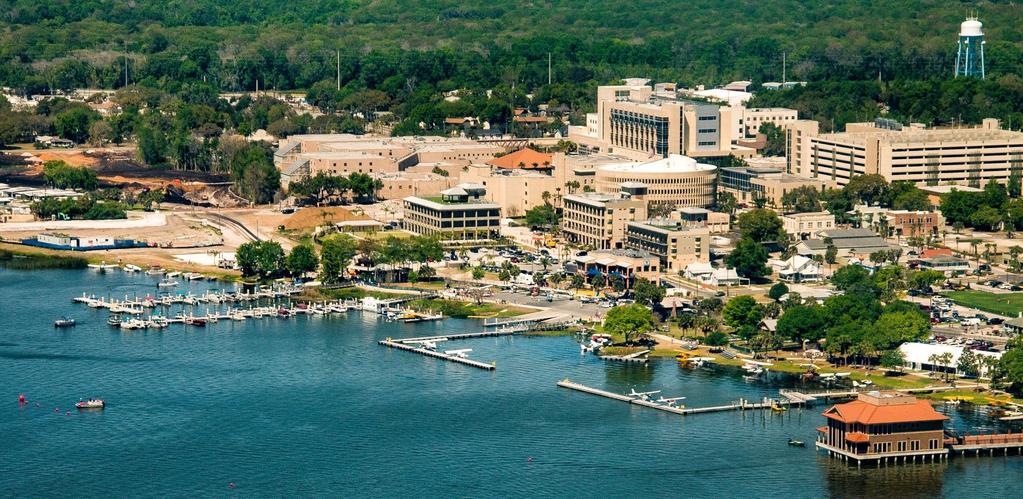
3 PULSIFER AVE PULSIFERAVE NEW HAMPSHIRE DOWNTOWN REDEVELOPMENT MASTER PL AN CIRCULATION AND CONNECTIVITY Street Network L AK E EUSTIS W BURLEIGH BLVD 500 FIRST UNITED METHODIST CHURCH OF W CAROLINE ST JUDICIAL CENTER LAKE INGRAHAM COUNTY JAIL DORACANAL ORANGE TRAFFORD HIGH SCHOOL E NELSON ST CIVIC CENTER & PUBLIC LIBRARY& RIDGE CITY HALL E KENTUCKY ST WOOTON L AK E DORA ,000 Feet CAPELLA SOUTH CAPELLA CLIFFORD I Downtown Tavares is currently served by a diverse transportation network system consisting of roadways, public transit and bicycle/pedestrian facilities. The Tav-Lee trail system combined with the sidewalk and alleyway network provides additional opportunities to design a complete system of linkages that connect the area both internally and with the surrounding neighborhoods. Because Downtown Tavares street grid is generally uniform with a minimal number of culde-sacs or dead ends, an efficient pedestrian and vehicular movement through the redevelopment area can be achieved by traveling along its primary roadways and neighborhood streets. There are two major transportation corridors serving the City and the Downtown CRA: U.S. Highway 441 which runs mostly east-west through the center of Tavares and SR 19 which runs generally northeasterly through the City. The overall goal of the this transportation component is to ensure the availability of an adequate and safe multi-modal transportation system throughout the CRA. The planned increase in density within the urban core is heavily dependent on an efficient and safe transportation system. Trail improvements and ultimate extension to Mount Dora, bike-share opportunities, golf cart access, pedestrian mobility and parking availability were identified by the community as crucial elements associated with the future success of Downtown Tavares. As Downtown s population increases and more employment centers are created within the redevelopment area, it is anticipated that trip generation will increase within the Downtown core and the surrounding neighborhoods. In order to support the community s overall goal to create a compact and complete community, and to promote alternative transportation modes that will ultimately reduce auto-dependence and increase walkability, the Plan recommends strategies that integrate land use and transportation principles to create an efficient circulation pattern. Highly visible and easily accessible locations are critical components of downtown redevelopment, therefore, the integration of transportation and land use requires a coordinated approach to establish an attractive, safe and efficient traffic circulation and pedestrian mobility system. Connectivity is one of the highest priorities for this plan. On the regional scale, this means providing connectivity routes via car, transit, bicycle, boat and foot to the Downtown. Objective 6-1: 6-1 Establish a safe, efficient traffic circulation and pedestrian mobility system that provides sufficient access, by diverse modes of transportation, to activity centers both within the Downtown CRA district and surrounding communities. Downtown Tavares overall physical structure, with blocks typically measuring 300 feet by 300 feet, is ideal for creating a safe pedestrian environment, allowing frequent intersections and interconnected areas. Majority of the County offices and retail areas in the Downtown are within a quarter-mile walking radius from the waterfront. Quarter-mile radius is the benchmark for a comfortable walking distance. During the 2017 Walking Tour/Audit, the walkability rating along the Civic Core, Downtown Transitional Corridor, the Waterfront Entrainment District and Main Street scored a satisfactory level while West Main Street scored poorly. Most street rights-of-ways are 80-feet wide, which is adequate to accommodate streetscape improvements including on-street parking and wider sidewalks as discussed in the previous chapter (Chapter 5: Urban Design and Historic Preservation). Exceptions to this width include Alfred Street, Caroline Street, and Ruby Street which are all slightly narrower. By improving the pedestrian environment it is anticipated that an increased number of people will choose to walk to their Downtown destination rather than to use their cars. Major residential and mixed-use development projects are recommended in this Plan. Pedestrian circulation plans must anticipate the additional demands and needs posed by these improvements and planned developments. The Redevelopment Plan establishes a hierarchy of connectors that will support existing and proposed residential, commercial, and recreational uses within the Downtown Redevelopment Area. The Plan establishes the following street typologies for Downtown s major thoroughfares and streets in order to better integrate vehicular and pedestrian traffic in the redevelopment area: Primary Commercial Corridor: SR 19 and US 441 US 441 and SR 19 serve as the major commercial thoroughfares designed to move residents and goods into and around the Downtown s residential, economic, education, and recreation centers. These corridors accommodate high traffic volumes from the regional centers, and are typically not designed to be pedestrian friendly. Serving as gateways into the Downtown, the corridors accommodate older suburban style commercial centers and industrial uses. The intent of the Plan is to create a more urban and pedestrian friendly environment while at the same time pursuing streetscape improvements that create a boulevard setting, particularly along the sections of the corridors that are within the redevelopment area boundaries. LEGEND CRA BOUNDARY EXISTING BUILDINGS EXISTING S OPEN SPACE PRIMARY ARTERIAL MINOR ARTERIAL COLLECTOR LOCAL ROADS HIGH TRAFFIC VOLUMES MODERATE TRAFFIC VOLUMES RAILROAD Fig. 6.1 Map illustrating roadway classifications: Downtown Tavares Source: City of Tavares, April 2017 DTRMP PART II CHAPTER 6: CIRCUL ATION AND CONNECTIVIT Y 87


4 DOWNTOWN REDEVELOPMENT MASTER PL AN Examples of different street typologies based on function and design treatment. Downtown Pedestrian Connectors: New Hampshire, Joanna, Texas, and Lake Avenues; Ianthe and Givens Streets These corridors serve as the primary linkages between the neighborhoods and the Downtown core, and have a residential orientation. These connectors are designed primarily for low volumes and low speeds of vehicular traffic with residential front yards, landscaped patios, and walkways serving as the transition between the public and private realm. Where possible, on-street parking is maximized on these streets, especially with the Downtown Core district. Downtown Transition Corridor: Alfred Street and Caroline Street As the name suggests, these corridors are intended to serve low-impact transitional office and retail uses while simultaneously minimizing the impacts on adjoining residential neighborhoods. The roadways provide a significant degree of vehicular mobility and are typically designed to accommodate low volume and low speed traffic, on-street parking and pedestrian traffic. The recent reconfiguration of Alfred Street and Caroline Street as a one-way pair is expected to further the goal to provide adequate buffers between the intense Downtown core and the residential neighborhoods. Although one-way pairs are often used to control traffic movement through a neighborhood, they are also considered detrimental to the economic vitality of core commercial areas. In the case of Alfred Street, the reconfiguration presents an opportunity to redesign the street as a pedestrian oriented mixed-use transition corridor with wide sidewalks, shade trees, and access to plazas. It is important to note that appropriate traffic calming devices and design of north-south streets at key intersections will be critical in achieving the desired traffic calming effect through the one-way pair conversion. Primary Retail Streets: Main Street and Ruby Street These streets are intended to serve as the retail and entertainment spines in the Downtown supporting neighborhood commercial and mixed-use areas. The streets are designed to accommodate a variety of transportation modes: pedestrians, vehicular traffic, transit service, and on-street parking. The eastern edge of Main Street within the Downtown core is currently designed to accommodate these activities. The Plan recommends designing Ruby Street as an entertainment district to complement the retail and office character envisioned for Main Street, and extending Main Street s existing character to the western edge of Downtown. Regional Connectors: St. Clair Abrams Avenue and Sinclair Avenue Regional connectors traverse a variety of uses and also serve as connectors linking the primary commercial corridors to the Downtown. Regional Connectors provide access for residents in the Downtown area to commercial, recreational, and institutional centers in the other parts of the city. Over time, as the Downtown will begin to attract more employers and witness an increase in residential populations, St. Clair Abrams Avenue and Sinclair Avenue are anticipated to serve as the regional connectors that will accommodate the traffic from the suburban communities to access the potential future commuter rail transit station on the waterfront. Objective 6-2: 6-2 Continue to invest in streetscape improvements along identified street typologies and strive to integrate land use and transportation planning strategies through the application of sound urban design principles. Action Strategies: 6.1 Conduct detailed studies to assess existing traffic patterns, and projected development forecasts in the Downtown core, and pursue related capital projects including streetscape improvements along the identified primary retail streets. 6.2 Coordinate funding and maintenance responsibilities among government entities including Lake-Sumter MPO, FDOT, and the railroad for identified roadway improvement projects. 6.3 Intentionally Deleted (Strategy Accomplished). 6.4 Intentionally Deleted (Strategy Accomplished). 6.5 Complete the surfacing of unpaved roads within the Downtown CRA district, as identified by the City s Department of Public Works. 6.6 Work with public and private sector entities to assemble properties and pursue streetscape improvements that will help transform Ruby Street into a pedestrian retail and entertainment street. 6.7 Discourage interruption of street grid system in future developments. 6.8 Formalize St. Clair Abrams Avenue and Sinclair Avenue as the area s major regional connectors through construction of roadway improvements and enhanced streetscape treatment. 6.9 Continue to prioritize identified streetscape projects in conjunction with other planned public and private sector improvements. 88 PART II CHAPTER 6: CIRCUL ATION AND CONNECTIVIT Y DTRMP 2017


.")

5 PULSIFER AVE PULSIFER AVE NEW HAMPSHIRE DOWNTOWN REDEVELOPMENT MASTER PL AN LAKE EUSTIS DORA CANAL 19 ORANGE 441 W BURLEIGH BLVD 500 INGRAHAM W CAROLINE ST TRAFFORD FIRST UNITED METHODIST CHURCH OF MAP OF PEDESTRIAN & BICYCLE NETWORK CRA BOUNDARY EXISTING BUILDINGS WOOTON PHASE II 1/4 MILE RADIUS TO WATERFRONT DESTINATIONS S JUDICIAL CENTER LAKE COUNTY JAIL LEGEND OPEN SPACE EXISTING SIDEWALKS SIDEWALKS NEEDED TAV - LEE TRAIL ROADWAYS RAILROAD HIGH SCHOOL E NELSON ST CIVIC CENTER & PUBLIC LIBRARY& RIDGE CITY HAL L E KENTUCKY ST WOOTON LAKE DORA ,000 Feet PROPOSED BICYCLE FACILITIES BICYCLE FACILITIES WITH ROADWAY IMPROVEMENT ALLEYWAYS Fig. 6.2 Map illustrating pedestrian and bicycle circulation: Downtown Tavares CAPELLA SOUTH CAPELLA CLIFFORD I Pedestrian, Alleyways and Bicycle Circulation Between 2007 and 2014, the City s Public Works Department formulated a plan with strategies to improve the walking conditions throughout the City. Over 16,000 linear feet of sidewalk and over 125 ramps were replaced and/or constructed to improve the existing pedestrian network system and meet current ADA compliance. In October 2014, a re-inventory of sidewalks and ramps was conducted by Vanasse Hangen Brustlin, Inc. (VHB). From 2014 to 2017, over 29,000 linear feet of sidewalk and over 225 ramps were replaced and/or constructed to continue the City s plan to improve the pedestrian network system and meet current ADA compliance. In addition to the replacement of damaged sidewalks and installation of missing sidewalks and ramps as needed, the City of Tavares Public Works Department developed an ongoing Sidewalk Grinding Program. This program removes identified trip hazards, creating a safe and comfortable pedestrian network system, at a much lower cost than conventional demolition and replacement methods. From , over 25 miles of sidewalk were inspected and a total of 1,580 hazards were removed through the Sidewalk Grinding Program at a cost savings of over $185,000. Nevertheless, implementing a complete sidewalk network is need especially in the industrial/commercial SR 19 and U.S. Highway 441(Burleigh Boulevard) corridor areas and in residential neighborhoods (See Appendix A, Figure A.15, for a sidewalk inventory). It is the intent of this Plan to formulate strategies that create a safe and comfortable pedestrian network system along selected corridors, through identification of key streetscape improvement projects and strategic clustering of land uses to create pedestrian activity nodes. (Refer to Chapter 5: Urban Design and Historic Preservation for detailed discussion on public realm design guidelines and recommendations related to extension of the existing street grid system.) Alleys are an integral part of the traffic and pedestrian circulation network linking neighborhoods and activity centers in a downtown. Alleys in Downtown Tavares are typically feet wide and run in the north- south direction, with the exception of three blocks that have alleys in the east-west direction. These alleyways are generally located in the blocks fronting Caroline and Ianthe Street between St. Clair Abrams Avenue and New Hampshire Avenue. The City recently initiated a pilot project to install permeable pavers in the alley located just north of Maud Street between Rockingham and St. Clair Abrams. Following the pilot project in 2007 where a half-block of alley was brick paved with permeable pavers, the City completed 11 ½ blocks of brick paving from Design engineering has been completed on 6 additional blocks of alley for brick paving as funding becomes available and 7 ½ blocks of alley have been identified for future brick paving improvement (See Appendix A, Figure A.14, for an alleyway inventory). Moreover, the location of the alleyway network in the Downtown continue to present opportunities to introduce unique pedestrian spaces that could accommodate diverse uses such as patios and cafes in commercial areas, and serve as narrow residential streets for secondary residential units. The urban design plan (Chapter 5) identifies several redevelopment opportunities that could be redeveloped with access from alleyways which in turn will improve the overall circulation by reducing the need for excessive curb cuts and traffic conflicts on street frontages. Bicycle circulation in the Downtown redevelopment area and the regional area is currently under developed. During the 2017 public meetings bike lanes along Main Street were identified as a priority. This is more relevant since the Alfred/Caroline Street one-way pair conversion do not facilitate for bike lanes. The Lake-Sumter MPO comprehensive long range transportation plan identifies improvements to the region s bikeways through a combination of on-street bicycle paths and greenways. The Plan recommends creating bicycle lanes as an integral component of all resurfacing and roadway projects, where appropriate. In addition to the sidewalk and alleyway network, the trail network plays an important role in completing the pedestrian and bicycle circulation system. The Lake County Master Plan envisioned the Tav-Lee Trail and the Tav-Dora Trail as being part of its master trail system which will eventually connects Regional and State trail systems (Wekiva Trail, West Orange Trail, Lake Denham Trail, etc.). The Tav-Lee Trail is planned to be a 21-mile-long recreational walking and biking trail that will start from SR 19 in Tavares and lead into Marion County, west of Lake County, via Leesburg and Fruitland Park. The City of Tavares obtained funding from FDOT for the construction of a Tav-Lee Trail extension that will extend the trail eastward approximately 1 mile, from SR 19 to Wooton Park. This will allow the park to feature a trailhead facility as an anchor for the Tav-Lee Trail within an upgraded recreation oriented waterfront setting. The trail will eventually connect with other recreational trails in the region, including Leesburg s Venetian Trail, which connects the east end of the City to its Downtown. The next big move of this Trail system will be to connect east to the City of Mount Dora. The Tav-Dora Trail is planned to connect City of Tavares to the City of Mount Dora. The shareduse trail is planned to follows adjacent to the Florida Inland Railroad for most of the 5.4 mile distance to Mount Dora. The exact route and design is being explored with Lake County s Master Trail Plan update. The ultimate goal will be to connect via the existing railroad right-of-way via either a Rails-to-Trails or a Rails & Trail program. The City along with the Lake-Sumter MPO are soliciting funding from FDOT for the expected Feasibility Study which will ultimately lead to a Project Development and Environment (PD&E) Study. Both are required before right-of-way acquisition and actual construction is able to start. The Plan recommends pursuing aesthetic improvements to the trail network and introducing trails as integral component of the street system, which will ultimately encourage more pedestrians and bicyclists to use the trail as an alternative travel mode to access Downtown. The City of Tavares is also actively promoting the use of alternative modes of transportation such as neighborhood electric vehicles, golf-carts, and segways on city streets in the Downtown redevelopment area. In conjunction with promoting these modes, the City has also implemented alternative modes of transportation including a seaplane basin and marina on Lake Dora. These initiatives will set the stage for creating a niche for Downtown Tavares as a complete community within the Central Florida region, providing connections to Downtown and beyond through improved multimodal transportation alternatives. DTRMP PART II CHAPTER 6: CIRCUL ATION AND CONNECTIVIT Y 89
 shows improvements to the trail system through application of CPTED principles: -Natural Surveillance -Territorial Reinforcement -Natural Access Control 6-3 Develop a safe,")

6 DOWNTOWN REDEVELOPMENT MASTER PL AN Objective 6-3: View of the trail connection along west side of Alfred Street. The illustration (below) shows improvements to the trail system through application of CPTED principles: -Natural Surveillance -Territorial Reinforcement -Natural Access Control 6-3 Develop a safe, efficient and aesthetically pleasing pedestrian and bicycle atmosphere that promotes connectivity between major uses and activity centers through appropriate design elements. A B A D G Signature palms to improve visibility C D G D F G E Trail User Amenities: Rest Area/ Furniture/ Lighting C G Action Strategies: 6.10 Develop detailed design specifications for improvements to the pedestrian system. The scope of the design specifications should include sidewalk design, infrastructure improvements, landscape materials and tree selection, street furniture specifications (lighting, bike racks, trash receptacles, benches) Intentionally Deleted (Strategy Accomplished) Develop detailed streetscape design specifications as part of the proposed Ruby Street/Waterfront Entertainment District design project Design and construct gateways at identified primary and secondary intersections Extend Main Street streetscape character to the western extent of Downtown between Sinclair Avenue and SR Continue to work with County to ensure planned improvements related to County facilities are implemented in accordance with the City s design specifications Require developers to install sidewalks in accordance with the City s design specifications within the Downtown core in all new developments Develop a pedestrian directory and walking map showcasing the historical and cultural amenities of Downtown Tavares Work with FDOT and the Lake-Sumter MPO to develop feasible right-of-way acquisition strategies along Ruby Street Complete missing sidewalk network and construct additional sidewalk enhancements for the Downtown Core District as the highest priority Provide mid-block connections and traffic calming devices along Alfred Street Analyze alternatives to enhance pedestrian connectivity across U.S. Highway 441 and SR 19, including feasibility of constructing a pedestrian/trail bridge at appropriate locations Limit curb cuts along US 441 and SR 19, and consolidate curb cuts with shared driveways, where possible Forge new pedestrian connections when possible, including providing pedestrian connections between Ruby Street in the West Main Neighborhoods District and the waterfront Work with property owners to connect Rockingham Avenue with US 441, when redeveloped Continue with promotion of alternative modes of transportation within the Downtown core such as golf carts, segways, and neighborhood electric vehicles Evaluate feasibility of creating a car-free demonstration area and multi-use paths for NEVs and Segways, preferably in the Waterfront Entertainment District, or alternatively restricting car access at certain times of the day and during special events Identify roads where NEVs are prohibited because of a speed limit greater than 35 miles per hour Identify and install appropriate signage and traffic controls that support use of NEVs and golf carts Develop long-range plans to identify locations that offer solar powered battery-charging stations and preferred parking for NEVs Develop internal traffic loop to accommodate the slowmoving vehicles within the overall roadway network Develop policies for implementation and installation of racks, lockers and other storage amenities within the Downtown redevelopment area Continue coordination efforts with Lake-Sumter MPO to extend the trail connection to Ruby Street and SR Continue with plans to construct Tav-Lee Trailhead facility and to extend the Trail (Tav-Dora) to Mt. Dora Create a detailed inventory of existing conditions to identify appropriate locations for constructing residential, commercial, and pedestrian alleyways Work with private sector to improve alleyways as part of redevelopment projects and require access to properties from designated alleys, where appropriate. B Gateway Treatment: Landscaping and Markers E Trail Identification: Signage C Shade Trees F Pavement Treatment G Burial of utilities/ Reduce signage clutter 90 PART II CHAPTER 6: CIRCUL ATION AND CONNECTIVIT Y DTRMP 2017

, St. Clair Abrams Avenue and Main Street, served primarily by Route 1 of the LakeXpress Service.")


7 DOWNTOWN REDEVELOPMENT MASTER PL AN Multimodal Transportation Given Downtown Tavares status as the county seat, the government facilities attract visitors and employees from the entire region. Lake County provides public transit serving the City of Tavares. However, there are no public transit terminals or transit stations within the City of Tavares. The County began the fixed-route transportation service, LakeXpress, in May In the future, the service is planned to be expanded to other urban areas of the County. Transit service in Downtown Tavares is restricted to SR 19, U.S. Highway 441(Burleigh Boulevard), St. Clair Abrams Avenue and Main Street, served primarily by Route 1 of the LakeXpress Service. While the bus service is slower than automobile access on a point to point basis, it allows for a more affordable and environmental friendly means to access the regional activity centers and communities. During the public meetings opportunities for bicycle/golf-cart share programs were also identified. Some type of ride-share program would contribute to motility, circulation and parking demand. Therefore, the City should explore this opportunity through a private-public joint venture. Lake-Sumter MPO has a strong desire to support innovative public transportation service and management concepts such as developing transportation demand management strategies, bringing commuter rail (SunRail) from Orlando to Tavares, working with the Leesburg International Airport to commence commercial passenger flights, and providing water access to Mount Dora, Tavares, Eustis and Leesburg through the Chain of Lakes/Lake County Blueways Plan. The City of Tavares is served by the Florida Central Railroad, which provides regional freight service throughout Lake County. This regional service connects the Lake County s industries to the CSX rail system hub located in Orlando, Florida. A future commuter rail line could possibly run along the Florida Central Railroad track from Eustis to Tavares, Zellwood, Apopka, Ben White, Altamonte Springs, Central Orange County, and into Downtown Orlando. The City of Tavares currently has an active seaplane basin and marina on Lake Dora. In 2012, the City, working with the East Central Florida Regional Planning Council, has adopted the Lakeside Mixed Use-Lake Dora category in the City s Comprehensive Plan which consist of a Freight Village near Southridge Industrial Park, south of Downtown on County Road 561. In order to accommodate envisioned residential and commercial growth in the Downtown CRA district, the Plan recognizes that transit service needs to be improved through strengthening existing relationships with appropriate agencies. The Plan recommends that the City continue to work with Lake-Sumter MPO to pursue improvements to the frequency and routing of the LakeXpress bus transit service serving Downtown Tavares. In addition, the Plan recommends evaluating the feasibility of introducing a trolley service making connections between major employment, entertainment and residential areas within the Downtown as a long-term strategy. Combined these strategies will create a pedestrian oriented environment which offers a diverse range of mobility options to users. The Plan envisions capitalizing on the opportunities that can be derived from the Central Florida commuter rail transit infrastructure to support the desired densification and physical expansion of the Downtown core, based on the principles of Transit Oriented Development (TOD). It is anticipated that the highest density districts consisting of the Waterfront Entertainment District, Transition Main Street District, and the Institutional/Civic Core will occur with a one quarter mile walking radius of the proposed transit station along Ruby Street. It is important to determine the feasibility of implementing a transit system and its relationship to physical, economic, and social factors including, but not limited to- infrastructure capacity, type of available and desired public transit services, transit station facilities design, roadway capacity to accommodate regional traffic, parking availability in close proximity to transit facilities, connectivity between different modes, potential target markets, available funding, and cost-benefit analysis of the transit service. The intent of TOD is to concentrate as much potential ridership as possible in close proximity to the station (a one quarter radius from the station, which translates into 125 acres per station). Implementation of a transit supportive plan typically occurs over a long period of time (10-30 years) and guides growth over the long-term. The development depends on market forces needed to create a complete community designed to meet the needs of a diverse and changing population. Distinguishing Characteristics of TOD: Public Transit as community focus within quarter-mile radius from the station (translates to 125 acres per station); Compact, mixed-use development (retail / entertainment at-grade; commercial / office and / or residential above); Medium-to-high densities (highest densities adjacent the station); Establish a grid street system with short blocks or passageways within longer blocks; Streets designed for multimodal access and circulation (cars, transit vehicles, bicycles and pedestrians); On-street parking wherever possible without intruding into local residential streets; Buildings fronting streets (rather than separated from street edges by parking lots); Avoidance of auto-related uses (car washes, drive-through restaurants); Pedestrian amenities such as street trees, lighting, plazas and parks; Preserve and / or enhance existing neighborhood character. Action Strategies: 6.36 Develop Transit Station Area Master Plan and conduct an infrastructure study to assess future needs related to the provision of commuter rail transit service Intentionally Deleted (Strategy Accomplished) Initiate designing and programming for future TOD Station Intentionally Deleted (Strategy Accomplished) Intentionally Deleted (Strategy Accomplished) Ensure that future development in the Waterfront Entertainment District is sensitive to long-term implications of sea plane basin related infrastructure facilities (aviation fueling, seaplane docking, ships store, and landing zone). This may include creating adequate landscaped buffers that will soften the visual impact of these support facilities Work with National Seaplane Pilots Association to promote the facility nationally Continue with plans to construct the marina (boat ramps/ marina store/ boat rentals) Develop standard agreements to negotiate minimum standards for public services and lease, operation and maintenance of the marina facilities Establish a waterway connectivity plan connecting Lake Dora to the Lake County Blueways Plan Evaluate the feasibility of purchasing a trolley and starting a shuttle service during special events between designated parking areas, major employers and the Downtown Continue to work with Lake-Sumter MPO to increase the number of routes and frequency of bus transit service required to ensure connectivity to the Downtown from the other sections of the City and Lake County. DTRMP PART II CHAPTER 6: CIRCUL ATION AND CONNECTIVIT Y 91

 of Downtown was an issue identified by")

8 DOWNTOWN REDEVELOPMENT MASTER PL AN Parking Parking is an important component of the Downtown s overall transportation network and influences various aspects of the Downtown s character including urban design, walkability, traffic circulation, and economic development. County and local government services, including the Judicial Center, the Courthouse, the Lake County Administration Building, and the City Hall are the primary parking generators in Downtown Tavares. During the visioning sessions conducted by City Staff in 2017, lack of parking on the east side (mainly due to the Pavilion on the Lake and/or special events) of Downtown was an issue identified by the participants. A parking inventory was conducted in April 2017 to assess the public and parking spaces available in the Downtown core district (Refer Appendix A). The biggest factor in 2017 compared to the 2008 parking/mobility analysis was the completion of the County parking garage and the Alfred/Caroline one-way pair street conversion. The County parking garage has increase parking spaces availability by approximately 1,555. These components have alleviate substantially the parking and traffic flow in the Downtown. Nonetheless, government facilities were still found to be the prime traffic and parking generators in the Downtown area. The Downtown area occasionally experienced parking congestion, particularly during the High School ceremonies/sporting events and/or special events on Wooton Park. Currently, the City of Tavares provides unlimited, free parking to all users with the exception of a few time limited parking spaces. The provision of free parking has hidden costs that are endured by the taxpayers primarily to provide a service to visitors that do not contribute directly to the local economy. Some of these costs include maintenance costs, untapped potential revenue resource and loss of possible customer base for local businesses. The Plan recommends that the City should consider adopting revenue generating alternatives as an effective parking management strategy over time. Any new parking structure should be located in the center of the lot and wrapped with retail, office or other active uses to serve as the primary façade. If a parking structure façade is located along a property line that is void of any streets, landscaping will be used to hide the appearance of such structure from adjacent properties. FIG 6.3 PROPOSED ING MAP: DOWNTOWN CORE As the residential and commercial base in the Downtown intensifies and it serves as a regional commuter transit hub, the parking demand is likely to increase. Effective management of on-street parking spaces is critical in providing access to employees, customers, business owners, and residents. Potential reconfiguration and striping of north-south streets in Downtown, as well as exploring shared parking opportunities could add more amount of spaces to the on-street parking spaces. As surface parking reaches its maximum capacity in the Downtown area, the City should seek opportunities to provide on-street parking when undertaking road improvement projects, where possible. As demand increases, the Plan suggests that the City seek opportunities to convert existing public owned underutilized lands, such as the Public Works site, into an additional structure parking facility. Fig. 6.3 illustrates a conceptual parking plan that identifies additional parking opportunities, both on-street and structured parking facilities, as the redevelopment area reaches its build-out capacity. Parking structures wrapped with retail, office or other active uses to serve as the primary façade: Precedent Structured Parking (Planned+ Proposed) Map showing proposed public parking opportunities: Downtown Core Tables showing existing and proposed parking spaces in the Downtown Core District and Downtown Transition District. Existing Parking Est. Count Projected Parking Capacity at build out On-Street Parking Spaces 235 On-Street Parking Spaces* Public Surface Parking Spaces 332 Public Surface Parking Spaces* Employee Surface Parking Spaces 174 Employee Surface Parking Spaces* Structured Parking (Shared/ Employee) 1,555 Structured Parking (Shared/ Employee)* Private Off-Street Parking 264 Private Off-Street Parking* Total Parking 2,560 Total Parking On-street parking (Existing+Proposed) Projected 1, , ,094 Source: City of Tavares, 2017 * Source: IBI Group, PART II CHAPTER 6: CIRCUL ATION AND CONNECTIVIT Y DTRMP 20 17


9 PULSIFER D O W N T O W N T A V A R E S R E D E V E L O P ME N T MA S T E R P L A N DOWNTOWN ING DISTRICT The City has established a Downtown Parking District (Fig. 6.4). According to the parking regulations, all new development and redevelopment of existing uses that are within the Commercial Downtown zoning district and the Downtown Parking District are exempt from any parking requirements with the following exceptions: Since its inception, the Downtown Parking District has facilitated many Downtown business that would otherwise have been unable to open. The additional on-street parking provided by the reconfigured Alfred and Caroline Streets also contribute to this provision. Accordingly, the City should explore the opportunity to expand this district to encompass a greater area BURLEIGH 500 FIRST UNITED METHODIST CHURCH OF HIGH SCHOOL CIVIC & PUBLIC LIBRARY KENTUCKY (1) One-hundred percent (100%) of any required handicapped parking must be provided. (2) Existing buildings as of April 19, 2000, that are used in whole or in part by federal, state, county or city governments for public purposes must provide seventy-five percent (75%) of the minimum off-street parking spaces identified in Table 20-A of the Land Development regulations for that portion of the building used for said purposes. (3) Buildings or additions constructed after April 19, 2000 that are used in whole or in part by the federal, state, county or city governments for public purposes must provide one-hundred percent (100%) of the minimum off-street parking spaces identified in Table 20-A of the Land Development Regulations for that portion of the building used for said purpose. (4) Where on-street parking is not available within 60 feet of the development site, seventy-five percent (75%) of the allowable off-street parking spaces identified in Table 20-A of the Land Development Regulations shall be provided on site. Additionally, the City has added Mixed Use (MU) zoning to the Downtown Parking District. According to the parking regulations, All new development and redevelopment of existing uses within the Mixed Use zoning district and the Downtown Parking District shall be required to provide fifty percent (50%) of the requirements of Table 20-A of the Land Development Regulations with the following exceptions: (1) One-hundred percent (100%) of any required handicapped parking must be provided. (2) Where on-street parking is not available adjacent to the development site, one hundred percent (100%) of the minimum off-street parking spaces identified in Table 20-A of the Land Development Regulations shall be provided on site. Action Strategies 6.48 Discourage frontage off-street parking in identified retail and transition corridors Develop and adopt standards to accommodate reduced parking requirements within the Downtown Core District and provide flexible spaces for compact cars Encourage shared parking and access between adjacent properties in commercial and mixed-use areas Maximize on-street parking by restriping north-south oriented streets, between Ruby Street and Caroline Street, to provide additional on-street parking spaces, where possible Evaluate alternative locations and feasibility of constructing public parking structures on the east side of Downtown Identify appropriate areas in the redevelopment area for event related spill-over parking and recreational vehicular parking Prepare a Downtown parking location map and install clear signage to designated parking areas Work with existing businesses and institutions to develop parking agreements that allow shared-use parking during special events and weekends Establish directional signage to the County public parking garage informing drivers about the facility s availability for public use on evenings, weekends, holidays, and during special events Develop special parking standards for neighborhood electric vehicles and golf carts as part of the Land Development Regulations update. DORA CANAL ORANGE INGRAHAM CAROLINE TRAFFORD Fig. 6.4 Downtown Parking District Map JUDICIAL CENTER LAKE COUNTY JAIL CITY HALL WOOTON LAKE DORA Tavares Downtown Master Plan, City of Tavares, FL LEGEND I 750 1,000 Feet CRA District Boundary Parking District Boundary City Boundary Park Railroad DTRMP 2017 PART II CHAPTER 6: CIRCUL ATION AND CONNECTIVIT Y 93


10 DOWNTOWN REDEVELOPMENT MASTER PL AN Airport Terminal Building in America s Seaplane City Tavares, America s Seaplane City, recently went from the little city that could to the little city that did, when it welcomed its 20,000 seaplane this past year. Its Seaplane Airport Terminal Building is possibly one of the smallest Airport Terminal Buildings in the United States and one of the most unique and charming as well. The airport terminal, appropriately named, The Prop Shop, boasts a passenger waiting lounge for the comfort and convenience of its guests and a gift shop with various sundries, unique aviation items and America s Seaplane City branded merchandise available for purchase. One of the first seaplane canoes invented in the 1950s for seaplane pilots who operated in the Alaskan and Australian bush is housed in a small museum area within the building. This historically rare canoe was designed to be broken down into two, 35-pound canvas duffle bags which when assembled, permitted the pilot to travel to remote villages to bring in medicine and other specialty village survival necessities. The Airport Terminal also has a seaplane ramp and water landing observation area which accommodates all necessary business transactions from fuel sales to the purchase of seaplane supplies. A unique feature of this Seaplane Airport Terminal Building is that it was architecturally designed asan exact replica of the historic 1871 Woodlea House, the home of the Gallant Captain Melton Haynes--a statesman and Civil War soldier (from Author Bob Grenier s book The Gallant Captain Melton Haynes 2003). 94 PART II CHAPTER 6: CIRCUL ATION AND CONNECTIVIT Y DTRMP 20 17
Chapter 5 Urban Design and Historic Preservation
 Chapter 5 Urban Design and Historic Preservation 65 URBAN DESIGN AND HISTORIC PRESERVATION Fig. 5.1 Proposed Urban Design Plan at complete build-out Source: City of Tavares, June 2017 LAKE DORA Lake Dora
The transportation system in a community is an
 7 TRANSPORTATION The transportation system in a community is an important factor contributing to the quality of life of the residents. Without a sound transportation system to bring both goods and patrons
Chapter 6. Circulation and Connectivity
 Chapter 6 Circulation and Connectivity ULSIFER AVE WOOD IBI ROU (FLORIDA) DOWNTOWN REDEVELOMENT MASTER LAN CIRCULATION AND CONNECTIVITY FOREST S DUNCAN DR WELLS LAKE EUSTIS SR 19 DORA ALM MANO 19 ORANE
TRANSPORTATION ELEMENT
 TRANSPORTATION ELEMENT GOAL I: To create and maintain a safe, efficient and aesthetic transportation system that encourages multi-modal transportation and promotes the mobility strategies of the Ocala
CHAPTER 7: Transportation, Mobility and Circulation
 AGLE AREA COMMUNITY Plan CHAPTER 7 CHAPTER 7: Transportation, Mobility and Circulation Transportation, Mobility and Circulation The purpose of the Transportation, Mobility and Circulation Chapter is to
Chapter 11. Implementation Plan
 Chapter 11 Implementation Plan 127 D O W N T O W N T AV A R E S R E D E V E L O P ME N T MA S T E R P L A N IMPLEMENTATION PLAN This section shows how the Master Plan translates to a phased series of
Town Center (part of the Comprehensive Plan)
") Town Center (part of the Comprehensive Plan) Mercer Island Town Center Looking North (2014) In 1994, a year-long process culminated in a set of design guidelines and code requirements for the Town Center
Town Center (part of the Comprehensive Plan) Mercer Island Town Center Looking North (2014) In 1994, a year-long process culminated in a set of design guidelines and code requirements for the Town Center
4.1.3 LAND USE CATEGORIES
 4.1.3 LAND USE CATEGORIES a. City Center District The City Center District incorporates the existing character and mix of uses in downtown Belmont to encourage redevelopment and new development in keeping
Transportation. Strategies for Action
 Transportation A major priority for the Overlake Neighborhood is to develop a multimodal transportation system. To achieve this system, a balance has to be found among travel, circulation and access needs;
Corridor Vision. 1Pursue Minnehaha-Hiawatha Community Works Project. Mission of Hennepin County Community Works Program
 1Pursue Minnehaha-Hiawatha Community Works Project Minnehaha-Hiawatha Community Works is a project within the Hennepin Community Works (HCW) program. The mission of the HCW program is to enhance how the
FUTURE LAND USE ELEMENT
 FUTURE LAND USE ELEMENT GOAL I: To create and sustain a great place to live, play, and prosper Objective 1: The City of Ocala shall incorporate the principles and strategies of the Ocala 2035 Vision into
1 Adapted from the Statewide Transit-Oriented Development Study by CalTrans, 2006
 APPENDIX C: LAND USE PLANNING FOR ENHANCED RAIL SERVICE 72 BACKGROUND One of the consistent themes heard from localities in the Route 29 corridor Planning Forums was the need for expanding rail service
Lehigh Acres Land Development Regulations Community Planning Project
 Lehigh Acres Land Development Regulations Planning Effort Summary In July, 2010 Commissioner Frank Mann invited the Lehigh Acres community to start discussing how to achieve their recently adopted community
ARLINGTON COUNTY, VIRGINIA
 ARLINGTON COUNTY, VIRGINIA County Board Agenda Item Meeting October 15, 2005 DATE: September 28, 2005 SUBJECT: Request to Advertise the adoption of the 2005 Clarendon Sector Plan C. M. RECOMMENDATION:
The University District envisions, in its neighborhood
 Envisioning the University District Link Light Rail in Seattle s neighborhoods CIY OF SEALE CONCEP-LEVEL SAION AREA PLANNING RECOMMENDAION RESOLUION # 30165 EXHIBI L Vision 08.2000 he University District
1.0 VISION STATEMENT. December 6, PRINCIPLES
 Vision Statement Lincoln Regional Airport 1.0 VISION STATEMENT 1.1 City LOCATION of AND OVERVIEW The Easton Lincoln Place Land Use Master Plan identifies the principles, goals, policies, and standards
SPRINGHILL LAKE TRANSIT VILLAGE
 Greenbelt Metro Area Sector Plan - Subarea Design Policies and Guidelines - Springhill Lake Transit Village 113 SPRINGHILL LAKE TRANSIT VILLAGE Residential Neighborhood and Village Center CONCEPT Springhill
Policies and Code Intent Sections Related to Town Center
 Policies and Code Intent Sections Related to Town Center The Town Center Vision is scattered throughout the Comprehensive Plan, development code and the 1994 Town Center Plan. What follows are sections
Comprehensive Plan ADOPTED APRIL 2014
 Comprehensive Plan ADOPTED APRIL 2014 8 8. Outstanding Recreational & Cultural Opportunities We are proud of our community s parks and recreation system. Our community will ensure that the legacy of our
DRAFT City of Titusville 2040 Comprehensive Plan Future Land Use, Housing, and Transportation Elements April 16, 2018
 DRAFT City of Titusville 2040 Comprehensive Plan Future Land Use, Housing, and Transportation Elements April 16, 2018 Prepared by Canin Associates for the City of Titusville About the Comprehensive Plan:
COMPLETE GREEN STREET CHECKLIST
 COMPLETE GREEN STREET CHECKLIST This document was developed to dissect the structure of an urban street and explore opportunities to make our streets more complete while also integrating green street strategies.
CHAPTER 3 VISION, GOALS, & PLANNING PRINCIPLES. City of Greensburg Comprehensive Plan. Introduction. Vision Statement. Growth Management Goals.
 CHAPTER 3 VISION, GOALS, & PLANNING PRINCIPLES Introduction The Greensburg Comprehensive Plan is intended as a working community document. A combination of long and short-term goals, this document is intended
5.1 Site Plan Guidelines
 5. Community Core Guidelines Development of the Community Core will take place by plan of subdivision and site plan approval. It will occur in a phased manner that will reflect the timing of residential
TRANSPORTATION ELEMENT GOALS, OBJECTIVES, AND POLICIES
 TRANSPORTATION ELEMENT GOALS, OBJECTIVES, AND POLICIES GOAL 2 The City shall provide a safe, convenient, effective, and energy efficient multimodal transportation system which is coordinated with the Future
Westwind Developments Ltd. PIONEER LANDS AREA STRUCTURE PLAN - PROPOSED AMENDMENT
 FEBRUARY 2013 TABLE OF CONTENTS 1.0 BACKGROUND... 1 1.1 Amendment... 1 2.0 LOCATION & CONTEXT... 2 2.1 Land Ownership... 2 3.0 POLICY CONTEXT... 3 3.1 Municipal Development Plan... 3 3.2 Capital Region
FDOT D4 Complete Streets
 FDOT D4 Complete Streets Context Sensitive Solutions Directs that complete street solutions will complement the context of the community. Collaborative approach to decision making, project development,
DRAFT ROOSEVELT ROAD. District Recommendations. Figure 5.23 The Roosevelt Road Corridor
 CHAPTER 5 Figure 5.23 The Road Corridor Road will develop as a mixed-use corridor, emphasizing regional retail, west of the river and mixed-use development east of the river. KEY RECOMMENDATIONS 1. High
WELCOME and introduction
 1 WELCOME and introduction Mobility Hub Locations within Burlington STUDY OVERVIEW STUDY OBJECTIVES The City of Burlington is developing four Area Specific Plans, one for each of Burlington s Mobility
Small Area Plan. South Gateway
 Small Area Plan Adopted May 12, 2008 South Gateway Purpose. The South Gateway Small Area Plan defines the City s expectations for the future of the southern entrance to the City at Interstate 85 and Highway
appendix and street interface guidelines
 appendix five: building and street interface guidelines appendix 5 building and street interface guidelines BOULEVARDS Boulevards are generally characterized by higher levels of traffic movement at higher
Establish a network of streetscaped vehicle and pedestrian routes that connect within and outside the Plan area.
 This Plan s urban design goals are to create an urban scale, walkable community with connections to transit, parks, and services and with amenities and facilities for residents and employees. The 1992
C. Westerly Creek Village & The Montview Corridor
 C. Westerly Creek Village & The VISION Community Vision When the goals of the city are achieved Westerly Creek Village, a distinctive community defined by Montview Boulevard and Westerly Creek, is a strong
City of Bristol Route 6 Corridor Implementation Program
 City of Bristol Route 6 Corridor Implementation Program FITZGERALD & HALLIDAY, INC. Innovative Planning, Better Communities June 2017 Route 6 Corridor Plan IMPLEMENTATION PROGRAM The following Implementation
3. VISION AND GOALS. Vision Statement. Goals, Objectives and Policies
 Vision Statement Queen Creek s interconnected network of parks, trails, open spaces and recreation opportunities provide safe and diverse activities and programs that sustain its unique, small town, equestrian
Be it enacted by the Town Board of the Town of Guilderland that the following new A (Transit Oriented Development (TOD) District) is adopted:
 District) is adopted:") Local Law No. 4 of 2018 (Adoption of 280-18A (Transit Oriented Development District) Be it enacted by the Town Board of the Town of Guilderland that the following new 280-18A (Transit Oriented Development
Local Law No. 4 of 2018 (Adoption of 280-18A (Transit Oriented Development District) Be it enacted by the Town Board of the Town of Guilderland that the following new 280-18A (Transit Oriented Development
Gold Line Bus Rapid Transit Transit Oriented Development (BRTOD) Helmo Station Area Plan
 Helmo Station Area Plan") Appendix F Gold Line Bus Rapid Transit Transit Oriented Development (BRTOD) Helmo Station Area Plan Introduction and Purpose of the Plan The Gold Line Bus Rapid Transit facility is an eleven-mile dedicated
Appendix F Gold Line Bus Rapid Transit Transit Oriented Development (BRTOD) Helmo Station Area Plan Introduction and Purpose of the Plan The Gold Line Bus Rapid Transit facility is an eleven-mile dedicated
Chapter 6--Urban Design
 6.1 Introduction... 6-1 6.1.1 Background & Scope... 6-1 6.1.2 Relationship to State Law... 6-2 6.1.3 Relationship to Other General Plan Chapters... 6-2 6.2 Guiding Principles... 6-2 6.3 Urban Design Guidelines...
Mark-up of the effect of the proposed Bronte Village Growth Area OPA No.18 on the text of section 24, Bronte Village, of the Livable Oakville Plan
 Mark-up of the effect of the proposed Bronte Village Growth Area OPA No.18 on the text of section 24, Bronte Village, of the Livable Oakville Plan Notes: This document is provided for information purposes
Chapter 4. Linking Land Use with Transportation. Chapter 4
 Chapter 4 Linking Land Use with Transportation Chapter 4 59 Chapter 4 Linking Land Use with Transportation Community Design and Transportation Program Introduction Since the 1950s, the predominant development
Clairtrell Area Context Plan
 Clairtrell Area Context Plan March 2005 Urban Development Services City Planning Contents 1. Introduction... 4 2. Development Structure... 6 2.1 Streets... 7 2.1.1 Sheppard Avenue and Bayview Avenue...
Table of Contents. Elm Avenue Improvement Plan City of Waco, Texas. Introduction 1. Existing Context 1 Figure 1 2.
 Table of Contents Introduction 1 Existing Context 1 Figure 1 2 Plan Guidelines 3 Future Urban Form 4 The West-End 4 Main Street 6 The East-End 7 Figure 2 9 Public Improvement Recommendations 7 General
ATTACHMENT A. SILVERDALE DESIGN STANDARDS Amendments to the Waaga Way Town Center Chapter
 ATTACHMENT A SILVERDALE DESIGN STANDARDS Amendments to the Waaga Way Town Center Chapter Chapter 10. Waaga Way Town Center 10.1 Physical Identity Elements & Opportunities The Waaga Way Town Center includes
Civic Center District
 Civic Center District The Civic Center district is the civic and social heart of Warrenville, containing such public buildings as the City Hall, Warrenville Public Library, Police Station, Park District
CHARLES PUTMAN CHARLES PUTMAN AND ASSOCIATES, INC
 MEMORANDUM CHARLES PUTMAN & ASSOCIATES, INC. LAND DEVELOPMENT CONSULTANTS PLANNING ZONING PERMITTING 4722 NW Boca Raton Boulevard, Suite C-106 Boca Raton, Florida 33431 Phone: 561/994-6411 FAX: 561/994-0447
Public input has been an important part of the plan development process.
 Lakewood s Comprehensive Plan recognizes that transportation helps shape the community, and that the way the community provides for the safe and efficient movement of people affects the character of the
Issues Requiring Future Study
 Issues Requiring Future Study Transportation planning is an ongoing process that tends to identify new issues as it finds solutions for others. Some issues are so complex that a solution to one problem
Midtown Greenway Land Use and Development Plan Executive Summary
 Midtown Greenway Land Use and Development Plan Executive Summary Introduction The Midtown Greenway Land Use and Development Plan sets policy direction for land use and development in the Midtown Greenway
PROPOSED REDEVELOPMENT OF THE GLEN ABBEY GOLF CLUB. STREETSCAPE DESIGN STUDY (excerpt from the Urban Design Brief) TOWN OF OAKVILLE.
 TOWN OF OAKVILLE.") PROPOSED REDEVELOPMENT OF THE GLEN ABBEY GOLF CLUB STREETSCAPE DESIGN STUDY (excerpt from the Urban Design Brief) TOWN OF OAKVILLE OCTOBER, 2016 for 2.4.2 STREETS Streets are the single largest component
PROPOSED REDEVELOPMENT OF THE GLEN ABBEY GOLF CLUB STREETSCAPE DESIGN STUDY (excerpt from the Urban Design Brief) TOWN OF OAKVILLE OCTOBER, 2016 for 2.4.2 STREETS Streets are the single largest component
TRANSIT ORIENTED DEVELOPMENT PINELLAS COUNTY MPO LIVABLE COMMUNITIES INITIATIVE PINELLAS COUNTY COMPREHENSIVE PLAN AMENDMENTS
 PINELLAS COUNTY MPO LIVABLE COMMUNITIES INITIATIVE MODEL LAND DEVELOPMENT CODE TRANSIT ORIENTED DEVELOPMENT PINELLAS COUNTY COMPREHENSIVE PLAN AMENDMENTS MPO Livable Communities Initiative Goal: Improve
SDOT DPD. SDOT Director s Rule DPD Director s Rule DCLU DR SED DR of 7 CITY OF SEATTLE
 SDOT SDOT Director s Rule 2-07 DPD Applicant: CITY OF SEATTLE Page 1 of 7 Supersedes: DCLU DR 11-93 SED DR 93-4 Seattle Department of Transportation (SDOT) Department of Planning and Development (DPD)
The Master Plan Framework
 The Master Plan Framework The East Harbour Master Plan advances the development of 60 acres of former industrial lands east of the Don River. The Master Plan outlines a vision for a vibrant, transit-oriented
The Need to Develop a Transit Ready Community
 Evaluation & Appraisal Report (EAR) Major Issue # 6 The Need to Develop a Transit Ready Community July 3, 2007 EAR Major Issue # 6 Transit Ready Existing Comp Plan policies apply only to Indiantown Road:
Today Land & People. Northeast Nampa Gateway District. Employment. Land Use Characteristics. Demographics. Current Zoning
 Today Land & People Employment Major employers include Saint Alphonsus, the College of Western Idaho, the Auto Mall, Sorrento Lactalis and Walmart. 3,004 jobs in 2010 (COMPASS-CIM 2040 TAZ data) 4,345
Proposed Comprehensive Plan Strategies DRAFT for discussion June 28, 2017
 Proposed Comprehensive Plan Strategies DRAFT for discussion June 28, 2017 Land Use Rural Areas Refine the Farm and Forest area (FF) Update FF boundaries to account for existing lots less than five acres
Metro. Activity Center Design Guidelines. Recommendations For Developing Focused, Mixed-Use Commercial/Residential Centers
 Metro Activity Center Design Guidelines Recommendations For Developing Focused, Mixed-Use Commercial/Residential Centers Metro Activity Centers What is a MAC? Legacy, the adopted guide for the future growth
PROTECT AND PROMOTE QUALITY OF LIFE AND LIVABILITY FOR THE CITIZENS OF GAINESVILLE THROUGH QUALITY URBAN DESIGN.
 Goals, & Urban Design Element PROTECT AND PROMOTE QUALITY OF LIFE AND LIVABILITY FOR THE CITIZENS OF GAINESVILLE THROUGH QUALITY URBAN DESIGN. GOAL 1 By 2003, the City shall adopt urban design standards
Executive Summary. NY 7 / NY 2 Corridor
 Executive Summary NY 7 / NY 2 Corridor Transportation and Land Use Study December 2005 Prepared for: Town of Colonie Capital District Transportation Committee Prepared by: Introduction: Land use decisions
PLAN ELEMENTS WORKSHOP. April 5, 2016
 PLAN ELEMENTS WORKSHOP April 5, 2016 needs more housing. But there is no one-size fits-all solution. Every neighborhood has its own character. In some places, density is not only appropriate it is badly
PLANNING COMMISSION WORKSESSION AGENDA. City Hall Second Floor Conference Room 9027 Center Street. July 1, :30 PM
 MEMBERS Harry J. Clark, Chairperson Bruce Wood, Vice-Chairperson Russell Harrison Ken Johnson Robert W. Schilpp Martha Wilson PLANNING COMMISSION WORKSESSION AGENDA City Hall Second Floor Conference Room
CHAPTER 1. Ms. Guajardo s Class - Central Elementary CH 1 1
 INTRODUCTION CHAPTER 1 Ms. Guajardo s Class - Central Elementary CH 1 1 1.1 SETTING South Centre City is a linear corridor south of Downtown Escondido paralleling Centre City Parkway and South Escondido
DOWNTOWN JACKSONVILLE MASTER PLAN S T R E E T H I E R A R C H Y
 DOWNTOWN JACKSONVILLE MASTER PLAN S T R E E T H I E R A R C H Y Gateway Intra-District Business Inter-District 44 CELEBRATING THE RIVER: A PLAN FOR DOWNTOWN JACKSONVILLE The Transportation Network This
Route 1 Corridor Study
 Route 1 Corridor Study Westbrook, Connecticut A Vision for the Connecticut Shoreline Public Informational Meeting July 28, 2015 Lower Connecticut River Valley Council of Governments Fitzgerald & Halliday,
Citizen Comment Staff Response Staff Recommended Revision Planning Committee
 Citizen Comment Staff Response Staff Recommended Revision Planning Committee Area No. 1: Owner desires retail land uses. Area No. 1a: Owner of two small parcels adjacent to Area No. 1 desires retail land
VISION AND GUIDING DESIGN PRINCIPLES
 pleasure point commercial corridor VISION AND GUIDING DESIGN PRINCIPLES Public Draft November 26, 2018 County of Santa Cruz with assistance from MIG CONTENTS PART I: INTRODUCTION AND VISION... 3 Community
FRUITVALE TRANSIT VILLAGE (Phase 2) Residential Project
 Residential Project") FRUITVALE TRANSIT VILLAGE (Phase 2) Residential Project DEVELOPER: SIGNATURE PROPERTIES ARCHITECT: HKIT ARCHITECTS April 23, 2010 TABLE OF CONTENTS 3 Vision 4 Description of Site 5 Guiding Concepts 6
FRUITVALE TRANSIT VILLAGE (Phase 2) Residential Project DEVELOPER: SIGNATURE PROPERTIES ARCHITECT: HKIT ARCHITECTS April 23, 2010 TABLE OF CONTENTS 3 Vision 4 Description of Site 5 Guiding Concepts 6
Windsor Locks Transit-Oriented Development Planning Grant Request. Project Background
 Windsor Locks Transit-Oriented Development Planning Grant Request Project Background Downtown Windsor Locks runs along Main Street in the vicinity of the intersection of Routes 159 and 140. The current
THE 355/270 CORRIDOR:
 THE 355/270 CORRIDOR: Strategic Ideas for Sustaining a Livable Work Place Project Summary ACCESS LIFE DESIGN HEALTH WORK Montgomery County Planning Department The Maryland-National Capital Park and Planning
Chapter 1 - General Design Guidelines CHAPTER 1 GENERAL DESIGN GUIDELINES
 CHAPTER 1 GENERAL DESIGN GUIDELINES 1.0 INTRODUCTION This Publication has been developed to provide current, uniform procedures and guidelines for the application and design of safe, convenient, efficient
DRAFT. 10% Common Open Space
 % OF CHARLOTTE IS CATEGORIZED AS A. LAND USES : Placeholder map displaying location of Place Type GOALS: Accommodate XX% of future growth. Provide a concentration of primarily commercial and civic activity
BROOKHILL NEIGHBORHOOD MODEL ZONING MAP AMENDMENT PREFACE TO APPLICATION
 BROOKHILL NEIGHBORHOOD MODEL ZONING MAP AMENDMENT PREFACE TO APPLICATION June 15, 2015 Revised: August 1, 2016 I. VISION Brookhill is a proposed community based upon the principles of Albemarle County
12/9/2013. HOLLYWOOD/PINES CORRIDOR PROJECT AMPO 2013 Annual Conference October 24, Our Perspective. Broward.
 HOLLYWOOD/PINES CORRIDOR PROJECT AMPO 2013 Annual Conference October 24, 2013 Our Perspective Broward Fort Lauderdale 1 Broward Metropolitan Planning Organization Fort Lauderdale Fort Lauderdale Skyline
EXISTING COMPREHENSIVE PLAN
 EXISTING COMPREHENSIVE PLAN Town Center Land Use Element: V. LAND USE POLICIES Town Center Mercer Island's business district vision as described in "Your Mercer Island Citizen-Designed Downtown" was an
A. Background Summary of Existing Challenges and Potential Possibilities. 1. Summary of Existing Assets and Potential Opportunities
 A. Background 1 A Main Street Master Plan Study was performed and completed in October of 2007. The study was initiated to review current land uses and development patterns along Main Street, from Parrish
The Five Components of the McLoughlin Area Plan
 The Five Components of the McLoughlin Area Plan This documents contains the complete language of the five components of the McLoughlin Area Plan: The Vision Statement The Values The Guiding Principles
EXHIBIT A. Tax Increment Reinvestment Zone No. 1 (Town Center) First Amended Project Plan 1
 First Amended Project Plan 1") EXHIBIT A Tax Increment Reinvestment Zone No. 1 (Town Center) First Amended Project Plan 1 1 As amended by Resolution No. 2008-02-001(TR1R) of the Tax Increment Reinvestment Zone No.1, and approved to
EXHIBIT A Tax Increment Reinvestment Zone No. 1 (Town Center) First Amended Project Plan 1 1 As amended by Resolution No. 2008-02-001(TR1R) of the Tax Increment Reinvestment Zone No.1, and approved to
Chapter 5.0 Guiding Principles
 Chapter 5.0 Guiding Principles TOD in the station area is more than adding higher density housing on the vacant sites near the Thornton Crossroads at 104th Station. The interweaving of the transit station,
PORT WHITBY COMMUNITY
 PORT WHITBY COMMUNITY SECONDARY PLAN UPDATE COMMUNITY IMPROVEMENT PLAN URBAN DESIGN GUIDELINES September 2015 DRAFT PROPOSED AMENDMENT NUMBER # to the Whitby Official Plan PURPOSE: The intent of this Amendment
City of Farmington. Downtown Plan. Amendment to the 1998 Master Plan Adopted October 11, 2004
 City of Farmington Amendment to the 1998 Master Plan Adopted October 11, 2004 Introduction Planning Background 1 Scope and Components of the Plan Amendment 2 Concept Introduction 3 Plan Concepts 3 Conceptual
Town Center. Block 5 Existing multifamily residential units are expected to remain.
 Area Guidelines Germantown s districts should be developed as distinct communities with unique features that are supported through the guidelines. The guidelines not only help distinguish these districts
The Village. Chapter 3. Mixed Use Development Plan SPECIFIC PLAN
 The Village SPECIFIC PLAN Chapter 3 3.1 INTRODUCTION 3.1.1 Purpose This Chapter describes the development regulations applicable to the Mixed-Use and Transit Center Planning Areas. These form-based regulations
Preliminary Recommendations Tk Takoma/Langley Crossroads Sector Plan
 Preliminary Recommendations Tk Takoma/Langley Crossroads Sector Plan Vision is to achieve a Transit Oriented, pedestrian friendly Community that Celebrates and builds upon the cultural Diversity of the
The West Vaughan Employment Area Secondary Plan Policies
 Part 2: The West Vaughan Employment Area Secondary Plan Policies 2.1 General Policies It is the policy of Council: 2.1.1. That the West Vaughan Employment Area (the WVEA), identified on Schedule 1, will
Complete Neighbourhood Guidelines Review Tool
 Complete Neighbourhood Guidelines Review Tool Prepared By: City of Regina Planning Department October 2014 Page 1 of 14 Community Development Review Checklist for Secondary Plans and Concept Plans The
9IMPLEMENTATION AND PHASING
 9IMPLEMENTATION AND PHASING Purpose A key objective of the Railyard Master Plan is the integration of the public and private realm to provide a network of places that connect to and complement Commercial
DRAFT Civic Center Station Area Plan. Executive Summary
 DRAFT Civic Center Station Area Plan Executive Summary This project is funded in part through the Metropolitan Transportation Commission s Station Area Planning Program. The preparation of this report
West Ocala Vision & Community Plan City Council Work Session. Presented by West Ocala Community Plan Steering Committee
 West Ocala Vision & Community Plan City Council Work Session Presented by West Ocala Community Plan Steering Committee November 29,2011 Ocala 2035 Vision West Ocala Community Vision & Master Plan West
Land Use. Hardware Street Vendor Mixed-Use
 Land Use Definition Land Use is the way a piece of real estate is utilized. Existing, proposed, and adopted land uses all play a role in the planning process. Once a land use plan is adopted, the next
City of Hermosa Beach Administrative Policy #
 City of Hermosa Beach Administrative Policy # SUBJECT: Living Streets Policy Date: Approved by: City Council Authority: Public Works Department & Community Development Department Mayor, PURPOSE The City
TRANSIT-ORIENTED DEVELOPMENT POLICY DRAFT. City Planning and Development Department Kansas City, Missouri
 TRANSIT-ORIENTED DEVELOPMENT POLICY DRAFT City Planning and Development Department Kansas City, Missouri What is Transit Oriented Development (TOD)? Development that focuses land uses around a transit
Figure 3-1: Public Realm Plan
 3 Public Realm Figure 3-1: Public Realm Plan 3.1 Public Realm Concept The public realm concept for the Little Mountain site integrates a clear and accessible movement network with public spaces for social
Millbrae TOD #2 Project Analysis
 Millbrae TOD #2 Project Analysis Project Description A Site Development Permit and Conditional Use Permit are proposed to allow for a mixed-use transitoriented development on approximately 9 Acres located
Chapter 1: Introduction
 Chapter 1: Introduction The Penn Avenue Community Works Corridor Vision and Implementation Framework presents an integrated communitybased vision and a coordinated, long-term implementation framework for
Implementation Guide Comprehensive Plan City of Allen
 Implementation Guide 2030 Comprehensive Plan City of Allen DRAFT 2015 Implementation Guide Allen 2030 Comprehensive Plan INTRODUCTION The Comprehensive Plan serves as a guide for the growth and development
FLORIN ROAD CORRIDOR Site Plan and Design Review Guidelines Checklist
 FLORIN ROAD CORRIDOR Site Plan and Design Review Guidelines Checklist Applicant s Name: Project Address: Phone: Email: Applicant shall fill out the design guidelines checklist for all guidelines applicable
ELMVALE ACRES SHOPPING CENTRE MASTER PLAN
 ELMVALE ACRES SHOPPING CENTRE MASTER PLAN Contents 1.0 INTRODUCTION... 2 2.0 LOCATION... 2 3.0 EXISTING CONTEXT... 2 4.0 VISION & GUIDING PRINCIPLES... 2 5.0 LAND USE AND BUILT FORM... 4 5.1 St. Laurent
IMPLEMENTATION STRATEGIES. In This Chapter. Goals & Strategies 182 Project List 183 Future Land Use 186 CHAPTER 11 IMPLEMENTATION STRATEGIES
 In This Chapter Goals & Strategies 182 Project List 183 Future Land Use 186 11 IMPLEMENTATION STRATEGIES NORTH AUGUSTA, SC 2017 COMPREHENSIVE PLAN 179 Individual commitment to a group effort that is what
Northwest commuter rail station US 36 BRT. Westminster Station
 Northwest commuter rail station Westminster Station US 36 BRT Westminster Center US 36 & Church Ranch Broomfield Flatiron/96 th St. US 36 & McCaslin Table Mesa Boulder Junction 13-month effort that will
DRAFT. October Wheaton. Design Guidelines
 October 2011 DRAFT Wheaton Design Guidelines 2 Draft - Design Guidelines - Wheaton Sector Plan Contents 04 Section 1: Introduction 06 Section 2: Context 08 Section 3: Design Guidelines 09 Goal 1: Create
Corridor Transformation Strategy
 Corridor Transformation Strategy County Road 22 Special Planning Area Design Guidelines January 2012 D14-06017 Corridor Transformation Strategy County Road 22 Special Planning Area Corridor Design Guidelines
PUBLIC RIGHT-OF-WAY IN THIS CHAPTER PUBLIC REALM
 PUBLIC RIGHT-OF-WAY This section provides design guidelines for improvements in the public right-of-way. The public right-of-way refers to streets, sidewalks, non-vehicular thoroughfares, parks and greenways