Ministry of Transportation. The Rt. Hon. Herb Gray Parkway A Parkway in a Prairie
|
|
|
- Malcolm Sherman
- 5 years ago
- Views:
Transcription


1 Ministry of Transportation The Rt. Hon. Herb Gray Parkway A Parkway in a Prairie

2 Acknowledgements The environmental contributions are the result of a collaborative effort involving many parties, notably; the Essex Region Conservation Authority, Amec Foster Wheeler, AECOM, City of Windsor, LGL limited, Dillon Consulting, Sage Earth, Windsor Essex Mobility Group, Parkway Infrastructure Constructors, Fisheries and Oceans Canada, the Ministry of Natural Resources and Forestry, Walpole Island First Nation, Dan Shab Enterprises, and many more.
3 Contents 1.0 INTRODUCTION Ecological Context ENVIRONMENTAL CONTRIBUTIONS Preservation and Restoration of Tallgrass Prairie Reducing Impacts to the Ojibway Prairie Complex Through Design Integrated Landscape Plan Species at Risk Fish Habitat Creation Wetland Preservation and Restoration Chappus Street Restoration Invasive Species Management Community Protection and Connection Ecopassages Excess Earth Management INNOVATION VALUING THE CONTRIBUTION Ecosystem Services & Climate Change Resiliency Application to Science Contributions to Biodiversity First Nation Consultation and Engagement Model Stewardship & Education Species at Risk Training APPLICATION TO TRANSPORTATION CONCLUSION... 7 List of Appendices Appendix A Aerial photo progression of Parkway construction.. 11 Appendix B Species at Risk by the numbers Appendix C Ecopassage tunnel top and ecopassage trail culvert Appendix D Chappus St. hibernacula creation and restoration Appendix E Innovations Appendix F Sod mat transplanting process Appendix G Contributions to new science i
4 1.0 INTRODUCTION The Rt. Hon. Herb Gray Parkway (the Parkway) is the access road portion of a new end-toend border transportation system between Windsor, Ontario and Detroit, Michigan; Canada s busiest land border crossing, which carries nearly one third of the trade between Canada and the United States. Identified under the Detroit River International Crossing (DRIC) Environmental Assessment (EA), the project is one of the largest infrastructure undertakings in Ontario to date, and was approved under both the Ontario Environmental Assessment Act and the Canadian Environmental Assessment Act. Located in the municipalities of Tecumseh, LaSalle and Windsor, the Parkway is a once-in-a-generation undertaking. The Provincial EA determined that much of the Parkway would need to remain in the existing highly urbanized corridor. The existing highway corridor which included 17 traffic signals, was congested with a mix of local and international traffic. The congestion resulted in localized air quality impacts, diversion of trucks to local streets, and had a negative economic impact due to border delays. The $1.4 billion Parkway includes an 11 km extension of the six lane Highway 401 and a parallel service road for local traffic. The Parkway includes 11 tunnels covering 1.8 km which provide linkages to adjacent communities and a wildlife crossing, 20 km of recreational trails that provide new community connections and more than 120 ha of greenspace. The Parkway is the first Ontario transportation project to be delivered by the Ministry of Transportation (MTO) and Infrastructure Ontario using an alternative financing and procurement approach. Appendix A portrays a photographic progression of the Parkway s construction. 1.1 Ecological Context The Ojibway Prairie Complex, which is adjacent to the Parkway, is the largest protected prairie in Ontario. Very little Tallgrass Prairie remains in North America with estimates ranging from 5% to less than 0.1%. Tallgrass Prairie ecosystems are the most endangered vegetation communities on Earth, and are home to many rare and endangered plant and animal species. The Parkway's ecological approach has resulted in an increase of over 100 ha of Tallgrass Prairie habitat in Windsor. In essence, we have created a Parkway in a Prairie. The Parkway also crosses, displaces or abuts 12 municipal drains that provide fish habitat. The objective during design was to achieve an overall net gain in fish habitat through replacement, restoration or enhancement. A Provincially Significant Wetland located along the southern boundary of the Parkway had to be considered relative to impact avoidance and the need to offset impacts. 2.0 ENVIRONMENTAL CONTRIBUTIONS An ecosystem approach involves understanding how the biological, human and physical components interact with nature and promote conservation and a sustainable design. The Parkway project demonstrates how to implement an ecosystem approach to the planning, design, construction, operation and maintenance of a highway. An integrated design team was fundamental to the successful implementation of an ecosystem approach. This team considered not only impacts but also opportunities afforded by every aspect of the work; from 1
5 opportunities to incorporate First Nation culture and tradition into the urban design of the Parkway, to using building demolition sites and materials to create snake habitat features. The robust natural heritage investigations conducted as part of the DRIC EA study were the foundation of the ecosystem approach. Another driver was the Endangered Species Act, 2007 (ESA), and the permits that were issued to the project as a consequence of impacts to Species at Risk (SAR). The environmental contributions outlined below are direct outcomes of the ecosystem approach. 2.1 Preservation and Restoration of Tallgrass Prairie Within the landscaped portions of the Parkway, 44.3 of the 120 ha of greenspace are created Tallgrass Prairie communities. Beyond the limits of the Parkway, 35.1 ha of Tallgrass Prairie are being restored to provide new and higher quality habitat for several SAR, in accordance with permits issued under the ESA. MTO is required not only to manage these sites until the expiry of the Permits in 2021, but also to ensure protection of these sites in perpetuity. A one-time effort involving the restoration of approximately 60 ha of the Spring Garden Natural Area is also being undertaken in partnership with the City of Windsor and the Essex Region Conservation Authority. Overall, the final design of the Parkway limited impacts to 0.4 ha of high quality ecological habitat. 2.2 Reducing Impacts to the Ojibway Prairie Complex Through Design A portion of the new highway was combined with a section of the E.C. Row Expressway with a resulting 25% reduction in impacts to sensitive habitat features for SAR snakes and to the Tallgrass Prairie ecosystem. In addition, refinement during design and construction resulted in further protection of landscape fragments that were incorporated into the overall landscape plan. 2.3 Integrated Landscape Plan In recognition of the global, national and provincial significance of the rare Tallgrass Prairie remnants in the Windsor Essex region, special measures were taken to ensure the protection, enhancement and restoration of ecosystems and associated habitats. An Ecological Landscape Plan covering over 75 ha was implemented that established an extensive habitat network consisting of existing, new and rehabilitated terrestrial and aquatic communities which are integrated with, and add to the biodiversity of existing ecosystems. Exclusively native seed and vegetation were planted that promote connectivity with adjacent prairie habitat. The scale of the planting effort was unprecedented for an MTO project as it included 120,000 trees, shrubs, and forbs representing 130 native species and 15 nonstandard seed mixes containing 106 different native species of prairie grasses, wildflowers, and sedges. Early planning efforts included seed bank salvage, and the development of a soil management plan. The development of an edge management plan minimized impacts to adjacent sensitive habitats. A comprehensive invasive species management plan was also 2
6 developed as invasives will pose an ongoing threat to the successful establishment of the ecologically based prairie landscape. A number of lessons learned and best management practices that have application to other large infrastructure projects have come from the implementation of the landscape plan. 2.4 Species at Risk The ESA permits included comprehensive mitigation, monitoring and long-term habitat protection for six plant and two snake SAR, and their critical habitats. To date, the results of the various mitigation and monitoring programs have revealed some significant findings, including previously unknown populations of these and other SAR; important species behaviours and habitat use; and the most successful methodologies for transplantation and propagation. Most significantly, through scientific trials, a method was found for propagating and transplanting Colicroot (Aletris farinosa), which was a requirement of the ESA permits because the project threatened the largest known population of Colicroot in Ontario. See Appendix F for photos of the transplanting process. The scale of the SAR program associated with the Parkway is summarized in Appendix B. An estimated 200,000 SAR plants have been successfully transplanted to protected restoration areas outside the corridor along with many rare associate plants. Traditional Knowledge was integrated into the transplanting efforts through the direct participation of Dan Shab Enterprises, a Walpole Island First Nation (WIFN) ecological business. Between 2008 and 2014, 504 Eastern Foxsnakes (Pantherophis gloydi) and Butler s Gartersnakes (Thamnophis butleri) were relocated from the construction footprint to protected Tallgrass Prairie areas. Relocated snakes have successfully selected new places to hibernate, lay eggs, and give birth to live young, exhibiting adaptability to new environments. 2.5 Fish Habitat Creation Overall, 35,000 m 2 of new fish habitat was created equating to a greater than 3:1 compensation ratio. The ecosystem approach was followed in targeting the creation of habitat that supported lifecycle requirements of the fish species involved. The drains crossing the original highway corridor were highly urbanized consisting of straight channels with an absence of key functional habitat features. Good quality spawning areas were also absent in upstream reaches of the drains. The new expanded highway right-of-way now includes for naturalized, meandering channels with new riparian cover. Refuge pools have been constructed that provide increased depth for fish during low flow periods. A new pond constructed on the Lennon Drain provides habitat for spawning, rearing, foraging and refuge for all of the resident species, including Northern Pike, a significant recreational fish within the Detroit River and some of its tributaries. The new pond has an area of approximately 2 ha and incorporates a permanent low flow channel. Stormwater runoff from the original at-grade highway surface flowed directly into drains with no quality controls in place. New stormwater controls provide overall benefits to water quality for aquatic life through the removal of sediment that would have previously been deposited in the drains from road surface runoff. Stormwater ponds adjacent to constructed 3
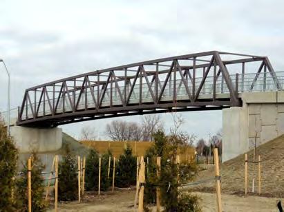
7 pond habitats have outlets that provide extended flows to refuge habitat in otherwise characteristically low flowing systems. 2.6 Wetland Preservation and Restoration The direct loss of 5.4 ha of provincially significant wetland has been offset by the preservation of over 45 ha of provincially significant wetland and associated buffer lands. These lands will provide habitat for many species, improve water quality and add natural capacity for flood storage. These ecosystem services add resiliency to the effects of climate change. In keeping with the ecosystem approach applied to the project, wetland and fisheries habitat creation areas have been integrated with SAR habitat restoration areas to provide enhanced habitat connections. The landscape design includes a 1,356 m 2 buffer and pin oak/deciduous tree swamp treatment surrounding the open water areas of the permanent fish habitat, which will benefit the overall wetland restoration efforts. As the 45 ha of land are owned by MTO, we have committed to providing the same long term protection to wetland preservation lands that will be provided to SAR restoration areas. 2.7 Chappus Street Restoration A former residential street was decommissioned and returned to its former natural state. Today the species diversity in this area rivals that of the nearby Provincial Nature Reserve. Appendix D shows a before and after photo series of the Chappus St. restoration area, today an integrated wetland/sar restoration area. 2.8 Invasive Species Management Next to habitat loss, the largest threat to Tallgrass Prairie is invasive species. Since 2009, invasive species have been systematically tackled using a variety of methods such as prescribed burns, brush cutting, selective use of herbicides and hand pulling. The Essex Region Conservation Authority has recognized the Parkway s invasive species work as the most progressive and comprehensive program in the region. The target species include european reed (Phragmites australis), autumn olive (Elaeagnus umbellate) and purple loosestrife (Lythrum salicaria). Ongoing monitoring will measure the effectiveness of management techniques. 2.9 Community Protection and Connection Urban communities and ecological areas bisected by the original corridor have been reconnected by placing Highway 401 below existing ground level and constructing a series of 11 tunnels, with one tunnel dedicated as an ecopassage. Noise attenuation was provided by building the highway below grade. Noise barriers, berms, and combinations of the two, were constructed wherever they were effective in further reducing noise levels. A new multi-use trail, approximately 20 km in length, allows residents and visitors to Windsor to travel the length of the trail without having to interact with vehicular traffic, thanks to a series of seven pedestrian bridges and two pedestrian tunnels. The trail provides new 4
8 linkages to municipal trails and facilities, and provides users with a closer connection to nature. The trail system is also part of the Trans Canada Trail. The trail will be an important regional asset supporting active transportation. An integrated landscape plan, together with aesthetic enhancements to structural (bridges and walls) elements and a series of interpretive panels and wayfinding signage will serve to attract users Ecopassages Three ecopassages have been designed for the Parkway project. The largest ecopassage is a tunnel top stretching over Highway 401 and Highway 3. This ecopassage measures approximately 14,500 m 2 (approximately the size of nine NHL hockey rinks) making it the largest ecopassage in the province. The ecopassage allows SAR snakes and other wildlife to cross between the Spring Garden Natural Area and Oakwood Prairie; two natural areas that have been separated since Huron Church Rd. was constructed in the 1920s. There is also an ecopassage beneath the trail crossing on the tunnel top to allow snakes to cross the trail unharmed. See Appendix C for photographs of these two ecopassages. A third ecopassage under Matchette Rd. (still to be constructed), will provide snake habitat connectivity between the Chappus St. restoration area and newly restored habitats to the west Excess Earth Management An estimated 1.5 million m 3 of the 3.5 million m 3 of excavated earth generated from the Parkway was re-used for construction and landscaping. The balance of the material was managed following current provincial best management practices directing that all earth be treated as a resource when considering appropriate uses. For example, 320,000 m 3 of earth was used to cap a closed landfill (Puce landfill), which will result in a significant reduction in leachate generated at the site requiring treatment and disposal, and capping the landfill 20 years earlier than originally planned. 3.0 INNOVATION Knowledge gained from the SAR program was the source of a number of environmental innovations. In addition, there were a number of engineering innovations that cumulatively provide net benefits by reducing energy consumption and greenhouse gas emissions. These innovations are summarized in Appendix E. 4.0 VALUING THE CONTRIBUTION At the time of construction, the Parkway was the single largest highway investment per kilometre in Ontario s history. The Parkway carries $300 million of goods daily between Canada and the United States. In addition, to meeting long term capacity needs for the crossing, this project addresses long-term community and environmental impacts associated with high volumes of commercial traffic traversing a local roadway. There are a number of other benefits that will accrue from the Parkway s investment in the protection and enhancement of environmental assets that extend well beyond the boundaries of the Parkway. 5
9 4.1 Ecosystem Services & Climate Change Resiliency The environmental work conducted in association with the Parkway is at a scale which provides broader regional environmental benefits. The ecosystem approach applied to the project led to an understanding of the interconnectedness of the Tallgrass Prairie and wetland area functions beyond the Parkway footprint. Land acquisition to meet regulatory requirements targeted areas which would help preserve this interconnected functionality. The Parkway s ecologically supportive landscape design further augments overall ecosystem health and associated regional ecosystem service benefits including the following: Improved water quality outflow Carbon sequestration through the extensive landscaping and protected vegetation Increased habitat for flora and fauna Natural flood storage/stormwater retention Improved soil quality 4.2 Application to Science All of the innovative research has a broader application to the scientific community. The SAR program has resulted in several significant advances in furthering the understanding of the biological and ecological requirements that will aid conservation and recovery initiatives for these species. These results are being integrated into species recovery strategies and long-term conservation planning. Perhaps the biggest contribution to the recovery of SAR will be the new science that has been revealed as a result of the monitoring which is an ongoing and long-term commitment. Appendix G summarizes contributions to the scientific community. 4.3 Contributions to Biodiversity MTO is listed as a supporting Ministry for many activities in the Ontario Biodiversity Strategy, The Strategy aims to protect, restore and recover Ontario's genetic, species, and ecosystem diversity, and related ecosystem functions and process. The design of the Parkway has helped support the Ontario Biodiversity Strategy by increasing habitat, planting native species and creating a variety of ecosystem communities. 4.4 First Nation Consultation and Engagement Model The project has benefited in many ways from over ten years of Walpole Island First Nation s (WIFN) engagement and offers lessons learned as a consultation model. The growth of Dan Shab Enterprises, a WIFN based ecological business, as a result of procurement opportunities on the project is just one of the tangible outcomes of having a First Nation relationship policy. 4.5 Stewardship & Education Trail signage and other interpretive features including seven coloured pedestrian bridges with First Nations based thematic treatments, will serve to educate trail users about the sensitivity and significance of the surrounding natural environment as well as First Nations culture. 6
10 Project team members have undertaken stewardship initiatives including sponsoring World Snake Day (now a yearly event at Ojibway Nature Centre), other children s events at the Ojibway Nature Centre, Elder College presentations and the creation of Environmental Newsletters for Windsor-Essex residents. 4.6 Species at Risk Training Great care was taken to ensure that all staff, contractors and sub-contractors working on the project were aware of the project s unique environmental setting. Every person who worked on site was required to take SAR training, which involved learning about the species on the project, what to do if a species was encountered and why it was important to care. Over 7,000 personnel working on the Parkway have completed SAR Training to date. Associated with the training program is a SAR Hotline. This is a number that workers on site can use to call a Parkway biologist, day or night. The information about SAR has carried over into the community, to family and friends, and onto other projects. 5.0 APPLICATION TO TRANSPORTATION The Parkway was necessary to improve border crossing capacity. The multi-jurisdictional planning process has improved traffic flow, while also addressing community and environmental needs through one of the largest individual EAs ever undertaken in Ontario. By following an integrated, ecosystem based approach to planning, transportation needs can be addressed within ecologically sensitive areas without jeopardizing overall environmental health and integrity. Early planning and consistency of application through the design and construction process, can also identify opportunities that add value with benefits beyond the immediate project area, including support of broader regional scale objectives. 6.0 CONCLUSION Methods and approaches to environmental management that have been used on the Parkway have application to other transportation infrastructure projects. Environmental contract specifications have subsequently been applied to other P3 projects, and the extensive environmental team that was involved in this project are now applying this knowledge and experience to effectively manage environmental design and construction projects across Ontario. While this submission has focussed on a number of the important environmental aspects of the project, there are also significant community, economic and transportation benefits at the local and regional levels that will accrue for generations. 7


11 Figure 1: Howard Avenue, 2006 Figure 2: Howard Avenue, 2013 Figure 3: Howard Avenue, 2015 Appendix A: Aerial photo progression of Parkway construction 11

12 Species at Risk Butler's Gartersnake Eastern Foxsnake Colicroot Dense Blazing Star Willowleaf Aster 4 found south of the E.C. Row 3 observed Appendix B: Species at Risk by the numbers 7 populations in Southern Ontario; ranging from 10 to NHIC Less than 100 in Windsor- Essex County - NHIC Less than 150 in Ojibway Prairie Complex - NHIC 109 found in MTO site on Chappus St. alone 2 found in the Parkway footprint 922 plants found in the Parkway footprint 537 plants found in the Parkway footprint 8,234 plants found in the Parkway footprint 339 captured in the study area 87 captured in the study area Population estimate is 8,303 individuals Population estimate is 76,525 individuals Population estimate is 416,205 individuals Appendix C: Ecopassage tunnel top and ecopassage trail culvert 12


13 Figure 2: Chappus Street Pre-demolition, 2012 Figure 3: Chappus Street Post demolition, 2013 Figure 4: Chappus Street Established vegetation, 2015 Appendix D: Chappus St. hibernacula creation and restoration 13
14 Appendix E: Innovations Activity Propagation of Colicroot Snake Habitat Features Sod Mat Transplant Method Snake Fence Designs Snake Radio Telemetry SAR Critical Path Scheduling The Innovation Through 10 scientific trials the Parkway team developed a successful method for growing Colicroot from seed. The successful method was used to meet the ESA permit compensation requirements and will have application to other restoration projects and will assist in the recovery of the species. Residential buildings were demolished on two residential streets and re-naturalized in areas of known SAR snake habitat. The demolitions provided an opportunity to create live birthing areas and hibernacula using the foundations and debris. This maintained site fidelity for snakes which had previously overwintered in these locations. The Parkway s customization of the Toronto Zoo hibernacula design has been successfully shared with others, including Point Pelee National Park, where the Parkway design was used on their last remaining cottage in In 2015, Point Pelee was able to confirm that the hibernaculum created from the basement of the cottage was successfully used by Eastern Foxsnakes that winter. A sod mat method was developed to efficiently and effectively relocate SAR plants and associative vegetation in 1m by 1m sections. 850 tonnes of Prairie soil with native seed bank was salvaged through this method. Transplants are thriving. See Appendix F for photographs of the process. A new barrier fence was developed specifically for the Parkway to keep snakes out of the highway corridor. Due to their known ability to climb, Eastern Foxsnakes were used to test different fence designs/ heights leading to a new permanent snake barrier design. 13 km of permanent snake barrier fence is installed. Development of new radio transmitter for implanting in the SAR snakes for radio tracking and monitoring of snake movements which has led to several scientific discoveries. The timing and scale of effort for SAR transplants and snake salvage posed a risk to the project schedule. A critical path was developed with leading construction specialists to demonstrate the feasibility of the construction staging. Aboriginal Procurement MTO was the first ministry to use the aboriginal procurement pilot project to procure the services of a Pilot Project First Nation business. The pilot was an initiative of the Ministry of Aboriginal Affairs intended to provide economic opportunities for First Nations. Human Health Risk Assessment W.E. pay it forward LED Lighting Stormwater Pumps Multi-lane Roundabout Traffic Management System (ITS/ATMS) AFP Delivery Model The EA required that the first MTO highway construction based Human Health Risk Assessment (HHRA) be conducted for the Parkway. As a result, the first HHRA modelling of its kind was undertaken and the outcome led to an innovative approach involving mitigating against risk through limiting equipment operation in higher risk locations during bad air days. This approach was undertaken without impact to the construction schedule. In a first of its kind pilot project, MTO partnered with local not-for-profit organizations to reclaim materials from buildings slated for demolition. The reclaimed materials were recycled back into the community through charitable housing and improvement initiatives. Remaining materials went to the Habitat for Humanity Re-store in Windsor. Between , 250 tonnes of material was redirected from landfills and the Re-store saw a quadrupling of profits from resold materials. The use of LED lighting in the tunnels, on the roadway and along the trails to reduce energy consumption. Use of special electronic starting mechanisms for the stormwater pumps to reduce energy consumption. Studies have shown the reduction of GHG emissions associated with the implementation of these facilities. Provide real time traffic info allowing drivers to make informed decisions about their routes to avoid delays, congestion and excessive idling. The construction of the project also employed stringent traffic management requirements to ensure that traffic delays and congestion were minimized. Provides incentives for the private sector to deliver under an accelerated schedule thereby reducing construction impacts and disruption for the travelling public and community. 14
 Radio-telemetry led to confirmation of BGS hibernation in chimney crayfish burrows. Hibernation Research funded by the Parkway concluded that BGS eat invasive earthworms.")
15 Appendix F: Sod mat transplanting process Thriving Colicroot population Appendix G: Contributions to new science Scientific Discovery Value added to the scientific community Butler's Gartersnake (BGS) Radio-telemetry led to confirmation of BGS hibernation in chimney crayfish burrows. Hibernation Research funded by the Parkway concluded that BGS eat invasive earthworms. Their BGS Food Source food source was previously unknown. BGS Live Birthing Areas Discovery of communal live birthing areas. Eastern Foxsnake and BGS relocation distances- exploratory behaviour, the fact that Snake Home Ranges they re-establish home ranges after relocation. Snake Movement Patterns Monitoring through radio telemetry shows adaptation to new habitats. Willowleaf Aster (WLA) (Symphynotrichum praealtum) Genetic Testing Genetic testing by the University of Guelph Herbarium confirmed that there was genetic diversity within the populations of WLA found in Windsor. This validated the approach of transplanting all individuals from the construction footprint. 15


16
DETROIT RIVER INTERNATIONAL CROSSING STUDY. County of Essex. June 4, 2008
 DETROIT RIVER INTERNATIONAL CROSSING STUDY County of Essex June 4, 2008 The Border Transportation Partnership 2 Purpose of the DRIC Study To provide for the safe, efficient and secure movement of people
The Border Transportation Partnership
 DETROIT RIVER INTERNATIONAL CROSSING STUDY Town of LaSalle June 10, 2008 The Border Transportation Partnership 2 1 Purpose of the DRIC Study To provide for the safe, efficient and secure movement of people
THE CORPORATION OF THE CITY OF WINDSOR Office of the City Solicitor Planning Department
 THE CORPORATION OF THE CITY OF WINDSOR Office of the City Solicitor Planning Department REPORT TO THE CITY OF WINDSOR PLANNING ADVISORY COMMITTEE DATE OF REPORT: August 19, 2010 SUBJECT: Official Plan
Study Process / Planning Policy Issues
 Memorandum Date: March 13 th, 2009 To: From: Reference: Subject: Murray Thompson, URS Canada Tyler Drygas, Senior Environmental Planner, URS Canada Detroit River International Crossing Study Response to
DETROIT RIVER INTERNATIONAL CROSSING STUDY. Walpole Island First Nations Meeting December 13, 2007
 DETROIT RIVER INTERNATIONAL CROSSING STUDY Walpole Island First Nations Meeting December 13, 2007 Agenda Study Status Results from August 2007 Public Information Open House Overview of the Parkway Alternative
5. Spring Garden Planning Area (Secondary Plan added by OPA #05 11/29/2002)
") 5. Spring Garden Planning Area (Secondary Plan added by OPA #05 11/29/2002) 5.0 Preamble THE PLANNING AREA FRAGMENTED OWNERSHIP PATTERN EMERGING LAND USE ISSUES IMPLEMENT STUDY FINDINGS The Spring Garden
5. Spring Garden Planning Area (Secondary Plan added by OPA #05 11/29/2002) 5.0 Preamble THE PLANNING AREA FRAGMENTED OWNERSHIP PATTERN EMERGING LAND USE ISSUES IMPLEMENT STUDY FINDINGS The Spring Garden
Red Hill Valley Project More Than A Road October 16, 2006
 Red Hill Valley Project Presented By: More Than A Road October 16, 2006 September, 2007 Gerry Davis, C.M.A., Senior Director, Capital Planning and Implementation Division Public Works Department City of
3-2 Environmental Systems
 3-2 Environmental Systems 3.0 ENVIRONMENTAL SYSTEMS CONTENTS 3.1 GREENWAY SYSTEM 3.1.1 General Policies 3.1.2 Natural Heritage Network 3.1.3 Natural Heritage Network Enhancement Lands 3.1.4 Rouge Watershed
TERRESTRIAL NATURAL HERITAGE SYSTEM STRATEGY APPENDIX F: MODEL POLICIES FOR THE IMPLEMENTATION OF THE TARGET TERRESTRIAL NATURAL HERITAGE SYSTEM
 TERRESTRIAL NATURAL HERITAGE SYSTEM STRATEGY APPENDIX F: MODEL POLICIES FOR THE IMPLEMENTATION OF THE TARGET TERRESTRIAL NATURAL HERITAGE SYSTEM C H A P T E R 1 M O D E L P O L I C I E S F O R I M P L
Roads and Ecological Integrity. Best Management Practices. September 2016: Version 1.1
 Roads and Ecological Integrity Best Management Practices September 2016: Introduction Most of the pressures on the ecological integrity of provincial parks can be linked to, or are made worse by roads.
CALGARY: City of Animals Edited by Jim Ellis
 CALGARY: City of Animals Edited by Jim Ellis ISBN 978-1-55238-968-3 THIS BOOK IS AN OPEN ACCESS E-BOOK. It is an electronic version of a book that can be purchased in physical form through any bookseller
Chapter 5: Natural Resources and Environment
 NATURAL RESOURCES AND ENVIRONMENT 5-1 5 Chapter 5: Natural Resources and Environment BACKGROUND AND INTENT Urban expansion represents the greatest risk for the future degradation of existing natural areas,
ENBRIDGE GAS DISTRIBUTION INC. Proposed Relocation for Ninth Line, Markham and Whitchurch-Stouffville. Environmental Screening Report
 Page 1 of 18 ENBRIDGE GAS DISTRIBUTION INC. Proposed Relocation for Ninth Line, Markham and Whitchurch-Stouffville Environmental Screening Report July 2011 Page 2 of 18 Table of Contents 1.0 INTRODUCTION
Township of Adjala-Tosorontio Official Plan Review. Natural Heritage
 Township of Adjala-Tosorontio Official Plan Review 13 Natural Heritage Introduction What is an Official Plan? An official plan is a municipal policy document which sets out the community s vision and strategies
Toronto Complete Streets Guidelines
 Toronto Complete Streets Guidelines 108 110 7.1 Green Infrastructure Design Principles 112 7.2 Context-Sensitive Green Streets 114 7.3 Key Green Street Elements Green infrastructure refers to natural and
Northeast Anthony Henday Drive Manning Freeway to Whitemud Drive Welcome to this Construction Information Session
 Manning Freeway to Whitemud Drive Welcome to this Construction Information Session Purpose To inform interested residents and businesses about the plans accommodation. Background: The Government of Alberta
2017 Canadian Consulting Engineering Awards
 2017 Canadian Consulting Engineering Awards Northeast Anthony Henday Drive DBFO Edmonton, Alberta Four years of detours, traffic snarls, varying speed limits, and stop-and-start driving has come to an
Presentation Overview
 DETROIT RIVER INTERNATIONAL CROSSING STUDY Presentation to Windsor Rotary Club October 23, 2006 1 Presentation Overview 1. Overview 2. Progress Update Technical Work Program Environmental Work Program
Biodiversity Action Plan Background Information for discussion purposes
 Biodiversity Action Plan Background Information for discussion purposes Our commitment As directed by Council, The City of Calgary has agreed to sign the Durban Commitment, an international agreement on
GREENBANK DEVELOPMENT MASTERPLAN
 DEVELOPMENT MASTERPLAN POTENTIAL TRAIN STATION COMMUNITY CENTRE Greenbank will be a connected masterplanned community providing easy access to local and surrounding amenity. Affordable quality homes, green
April 11, 2016 Park Board Chair and Commissioners General Manager Vancouver Board of Parks and Recreation New Brighton Salt Marsh - Preferred Concept
 TO: FROM: SUBJECT: April 11, 2016 Park Board Chair and Commissioners General Manager Vancouver Board of Parks and Recreation New Brighton Salt Marsh - Preferred Concept RECOMMENDATION A. THAT the Vancouver
Objectives and Strategies for the Integration of Recreation, Parks and Open Space in Regional Plans
 BULLETIN 2 Objectives and Strategies for the Integration of Recreation, Parks and Open Space in Regional Plans TABLE OF CONTENTS Introduction 3 Land-use Framework Outcomes 1 4-8 Land-use Framework Outcomes
3.0 master plan concept
 3.0 master plan concept 3.1 introduction The purpose of the Huron Church Road Master Plan Concept is to provide an overview of the Master Plan design process, identify preliminary streetscape installations
WELCOME! 8 8:30 6: TH STREET IMPROVEMENTS. Open House. Presentation & Q&A
 WELCOME! 168 TH STREET IMPROVEMENTS 6:30 Open House 7 8 Presentation & Q&A 8 8:30 Open House WELCOME Todd Pfitzer City of Omaha Engineer Bob Stubbe City of Omaha Public Works Director Jon Meyer Project
AT THE HEART OF LAND & WATER MANAGEMENT ON TWEED. tweedforum.org
 AT THE HEART OF LAND & WATER MANAGEMENT ON TWEED Why do we exist? The Tweed is one of the region s greatest assets. It provides a focal point for our natural, built and cultural heritage and a multitude
Design Around Waterways and Wetlands
 Design Around Waterways and Wetlands NL Green Economy Conference Newleef-2014 NEIA, St. John s, NL October 9-10 th, 2014 Wade Lewis Amherst, Nova Scotia, w_lewis@ducks.ca DUC conserves, restores and manages
TRCA Field Staking Protocol December 2016
 Page 1 of 6 TRCA Field Staking Protocol December 2016 This Protocol describes TRCA staff s current practice for field staking the physical top of bank, the physical toe of slope, and the limit of existing
10.0 Open Space and Public Realm
 10.0 Open Space and Public Realm 10.0 Open Space and Public Realm The Public Open Space System is comprised of: outdoor spaces available for public use that are either publicly owned (e.g., parks and
APPENDIX 1: SCOPED ENVIRONMENTAL IMPACT STATEMENT (EIS) FORM
 FORM") APPENDIX 1: SCOPED ENVIRONMENTAL IMPACT STATEMENT (EIS) FORM This form is intended for use by applicants (primarily private landowners) who need to conduct a Scoped EIS in support of minor development
APPENDIX 1: SCOPED ENVIRONMENTAL IMPACT STATEMENT (EIS) FORM This form is intended for use by applicants (primarily private landowners) who need to conduct a Scoped EIS in support of minor development
Fostering Indigenous Relationships Within Canada - How Far We Have Come: A View from Walpole Island First Nation
 Fostering Indigenous Relationships Within Canada - How Far We Have Come: A View from Walpole Island First Nation Dean M. Jacobs Ontario West Regional Conference Consultation Manager London, Ontario Walpole
Programming Ideas for Parks Professionals
 Programming Ideas for Parks Professionals 6 How to Use this Information This is a list of ideas, suggestions and tips for promoting and incorporating the healthy in nature movement in your parks. Whether
Environment and Sustainability. Environment and Sustainability
 4 Environment and Sustainability Environment and Sustainability ENVIRONMENT AND SUSTAINABILITY 4.1 CLIMATE CHANGE AND AIR QUALITY... 4-5 4.1.1 OBJECTIVES... 4-6 4.1.2 POLICIES... 4-6 4.2 NATURAL HERITAGE
Presentation to Planning Committee, DMM
 District Municipality of Muskoka Muskoka Official Plan Review Background Study: Natural Heritage Review of Urban Centres and Species At Risk Dale Leadbeater 1 September 2011 Presentation to Planning Committee,
Sewing the Seeds for a
 Sewing the Seeds for a Green Development Strategy Quote from -Thomas Mueller; President of the Canadian Green Building Council Buildings account for as much as 48% of energy consumption & greenhouse gas
GUIDELINES FOR ECOLOGICAL PERFORMANCE
 3 Landscape........................................... 3.2 Stormwater Management................................... 3.3 Hardscape........................................... 3.4 Streetscape..........................................
GEOMETRIC IMPROVEMENTS AND WATERMAIN LOOPING MUNICIPAL CLASS ENVIRONMENTAL ASSESSMENT
 GEOMETRIC IMPROVEMENTS AND WATERMAIN LOOPING MUNICIPAL CLASS ENVIRONMENTAL ASSESSMENT Veterans Way (previously Powerline Road) and Klondike Park Road Wasaga Beach Welcome Please sign in Take a comment
UNIVERSITY TOWN NEIGHBOURHOODS 5.2 ECO-CORRIDOR MELBOURNE CAMPUS MASTER PLAN 2014
 5.2 ECO-CORRIDOR 37 ECO-CORRIDOR EXISTING CONDITIONS & VISION NEIGHBOURHOOD VISION Investment in the Eco-corridor Neighbourhood will signify the University s commitment to supporting local ecology and
2007 TAC SUSTAINABLE URBAN TRANSPORTATION AWARD SUBMISSION. Bridge Over Highway 401 for Pedestrians and Cyclists in Waterloo Region
 2007 TAC SUSTAINABLE URBAN TRANSPORTATION AWARD SUBMISSION Bridge Over Highway 401 for Pedestrians and Cyclists in Waterloo Region Project Partners: City of Cambridge City of Kitchener Region of Waterloo
Hartest river corridor survey
 Hartest river corridor survey Project no. Report Date 56/15 Final 21st September 2015 Prepared by Penny Hemphill BSc. Hons Checked by Simone Bullion BSc. Hons, PhD., MCIEEM SWT Trading Ltd Suffolk Wildlife
APPENDIX K WINDSOR OFFICIAL PLAN
 CEAA ENVIRONMENTAL ENVIRONMENTAL IMPACT ASSESSMENT AMBASSADOR BRIDGE ENHANCEMENT PROJECT Replacement Span and Plaza Expansion APPENDIX K WINDSOR OFFICIAL PLAN Avalon Consulting Professionals of Ontario,
Western Sydney Parklands Australia s Largest Urban Park
 Western Sydney Parklands Australia s Largest Urban Park 37 WLA 1 MAGAZINE 21 38 WESTERN SYDNEY PARKLANDS AUSTRALIA S LARGEST URBAN PARK Large urban parks have dual roles to play in meeting the demands
Slough International Freight Exchange Proposals, Colnbrook+
 Welcome Welcome to this exhibition, which is being held in connection with our proposals for a new freight exchange facility on land to the north of the A4. Please take this opportunity to look at the
1 Introduction. Chapter. In this chapter:
 Chapter 1 Introduction In this chapter: 1.1 A Snapshot of the Region 1.2 Towards a Sustainable Region 1.3 The Provincial Context 1.4 Purpose and Organization The Regional Municipality of York Official
Rocky Areas Project Guidance HABITAT
 Rocky Areas Project Guidance HABITAT Introduction Rocky habitats are surface areas dominated by exposed rock, such as mountain peaks, inland cliffs, buttes and rocky outcrops. In many cases, rocky areas
An Introduction to the Far North Land Use Strategy
 An Introduction to the Far North Land Use Strategy December, 2013 Ministry of Natural Resources Table of Contents PREFACE... 3 About the Far North... 3 Evolution of Land Use Planning in the Far North...
National Association of Conservation Districts. Kris Hoellen Vice President, Sustainable Programs The Conservation Fund September 19, 2013
 National Association of Conservation Districts Kris Hoellen Vice President, Sustainable Programs The Conservation Fund September 19, 2013 Our Mission The Conservation Fund forges partnerships to conserve
Describing the Integrated Land Management Approach
 Describing the Integrated Land Management Approach ISBN No. 978-0-7785-8902-0 (Online Edition) Pub No. I/422 What is Integrated Land Management? Integrated land management (ILM) is the strategic, planned
VCA Guidance Note. Contents
 Contents 1. Introduction... 2 2. Who can register a VCA?... 2 3. VCAs and sustainable development... 3 4. Verifying conservation performance... 4 4.1 Transparent, voluntary commitments... 4 4.2 Independent
Illiana Corridor CPG/TTF Meeting #1
 Illiana Corridor CPG/TTF #1 March 14, 2013 #10 1 Agenda Tier One Recap What happens in Tier Two? Tier Two Purpose and Need Identify Range of Alternatives Landowner Outreach Initial Context Sensitive Solution
AMENDMENT NO. 30 TO THE OFFICIAL PLAN OF THE TOWN OF MILTON
 AMENDMENT NO. 30 TO THE OFFICIAL PLAN OF THE TOWN OF MILTON Subject: Boyne Survey Secondary Plan and Related Official Plan Amendments The following text and schedules constitute Amendment No. 30 to the
Ashbridges Bay Erosion and Sediment Control Project
 Ashbridges Bay Erosion and Sediment Control Project Project Brief Overview Toronto and Region Conservation Authority, in partnership with the City of Toronto, intends to carry out remedial erosion control
Report to: Development Services Committee Report Date: April 24, 2017
 SUBJECT: Cornell Rouge National Urban Park Gateway - Report on Design Charrette and Next Steps PREPARED BY: Lilli Duoba, MES, MCIP, RPP, Manager, Natural Heritage (ext. 7925) REVIEWED BY: Marg Wouters,
Chairman and Members of the Planning and Development Committee. Thomas S. Mokrzycki, Commissioner of Planning and Building
 LA.09.TOR (Toronto) DATE: TO: FROM: SUBJECT: Chairman and Members of the Planning and Development Committee Thomas S. Mokrzycki, Commissioner of Planning and Building Central Waterfront Secondary Plan
Rouge River Gateway Master Plan Update: 2011
 Rouge River Gateway Master Plan Update: 2011 Environmental Stewardship Cultural Heritage Recreation Economic Development Rouge Gateway Master Plan (2001) 1 Rouge Gateway Master Plan Update (2005) Significant
SAN RAFAEL GENERAL PLAN 2040 INTRODUCTION AND OVERVIEW
 SAN RAFAEL GENERAL PLAN 2040 INTRODUCTION AND OVERVIEW Steering Committee Presentation February 14, 2018 Purpose of General Plan Guide land use and development decisions Coordinate transportation, infrastructure,
Wetland Design Manual. A1: Vision, core outcomes and aspirational outcomes
 Wetland Design Manual A1: Vision, core outcomes and aspirational outcomes Table of contents Introduction 5 Vision 6 Core outcomes 7 Effective pollutant removal and flow management... 7 Community safety...
NON-TECHNICAL SUMMARY
 Proposed Sand and Gravel Extraction and Associated Processing Operations with Restoration to a Mixture of Agriculture and Nature Conservation including Areas of Shallow Water at Hedgeley, Northumberland
An Ambitious Plan: Transforming the blighted South Platte River and surrounding environment into Denver s greatest natural resource.
 CONNECTING THE PEOPLE TO THEIR RIVER SOUTH PLATTE RIVER VISION IMPLEMENTATION PROGRAM: GRANT-FRONTIER PARK TO OVERLAND POND PARK REACH The South Platte River Vision Implementation Program (River Vision)
CHAPTER 8 ISSUES, CONCERNS, CONSTRAINTS AND OPPORTUNITIES
 CHAPTER 8 ISSUES, CONCERNS, CONSTRAINTS AND OPPORTUNITIES Introduction This River Conservation Plan was developed during a time of tremendous activity and effort in planning the transformation of the Delaware
Services Department B September 10, 2007
 Report To: Development Services Committee Item: Date of Report: DS-07-246 September 5, 2007 From: Commissioner, Development File: Date of Meeting: Services Department B7200-0001 September 10, 2007 Subject:
RESPONSES TO PUBLIC CONCERNS AND QUESTIONS
 RESPONSES TO PUBLIC CONCERNS AND QUESTIONS Stations and Summary Questions for Public Meeting #2 June 23, 2015 General Questions / Concerns: 1. Is there any way this development can raise revenue for the
Green Infrastructure. by Karen Engel, NYS DEC. NYS Department of Environmental Conservation
 Green Infrastructure by Karen Engel, NYS DEC What is Green Infrastructure? For some it s all about water Green Infrastructure techniques use soils and vegetation to infiltrate, evapotranspirate, and/or
PRESENTATION ON JOHANNESBURG S BIODIVERSITY PROGRAMME
 PRESENTATION ON JOHANNESBURG S BIODIVERSITY PROGRAMME Member of Mayoral Committee: Cllr Prema Naidoo Environmental Management & Johannesburg City Parks PRESENTATION OVERVIEW Jo burg Overview & Context
This presentation has been developed by the Sustainable Sites Initiative for general audiences
 This presentation has been developed by the Sustainable Sites Initiative for general audiences Copyright 2011 by the Sustainable Sites Initiative. All rights reserved. 2011 2010 Sustainable Sites Initiative
APPENDIX L3. Table of Contents. SWP EA Information Sheets
 E N V I R O N M E N T A L A S S E S S M E N T APPENDIX L3 SWP EA Information Sheets Table of Contents EA Info Sheet 1... L3-1 EA Info Sheet 2... L3-3 EA Info Sheet 3... L3-5 EA Info Sheet 4... L3-7 SCARBOROUGH
City of Surrey Ecosystem Management Study. Integration of ecological processes with land use
 City of Surrey Ecosystem Management Study Integration of ecological processes with land use Natural areas in Surrey are changing as the City grows and evolves. Many important natural areas remain or may
Infrastructure, Development and Enterprise Services. Natural Heritage Action Plan (NHAP) Project Initiation
 Project Initiation") Staff Report To Service Area Committee of the Whole Infrastructure, Development and Enterprise Services Date Monday, March 6, 2017 Subject Natural Heritage Action Plan (NHAP) Project Initiation Report
Staff Report To Service Area Committee of the Whole Infrastructure, Development and Enterprise Services Date Monday, March 6, 2017 Subject Natural Heritage Action Plan (NHAP) Project Initiation Report
Second Line West Pedestrian/Cyclist Crossing of Highway 401 Class EA. Second Line West Pedestrian/Cyclist Crossing of Highway 401 Class EA
 1 1 Purpose of Public Information Centre #2 To provide interested and/or potentially affected stakeholders with an opportunity to participate in the planning and decision-making process for this Municipal
At the Heart of the Great Lakes
 Walpole Island Heritage Centre May 2010 At the Heart of the Great Lakes Bkejwanong: Where the Waters Divide Bkejwanong s Ecosystems OVERVIEW Walpole Island supports a rich mosaic of natural areas including
APPENDIX I Presentations
 APPENDIX I Presentations Workshop Summary Report 11 Peel Region Official Plan Review May 5, 2010 Compatible Active Recreation Workshop July 29, 2010 Components of PROPR Sustainability Planning Tools/Updates
2011 ASLA Design Awards. Coyote Gulch Honor Award and Land Stewardship Designation Valerian LLC. Environmental Restoration and Reclamation
 2011 ASLA Design Awards Honor Award and Land Stewardship Designation Valerian LLC Environmental Restoration and Reclamation Project Name: Category : Project Location: 5 2011 Environmental Restoration and
2011 ASLA Design Awards
 2011 ASLA Design Awards Interstate 70 Mountain Corridor Aesthetic Guidance Honor Award Design Workshop, Aspen / THK Associates, Inc. / CH2MHill Planning and Urban Design Project Title: Interstate70 Mountain
Better Cycling. The City will update the cycling master plan (London ON Bikes) based on the approved BRT network.
 based on the approved BRT network.") Better Cycling Dedicated bike facilities will be constructed along BRT corridors where space is available. Nearby bike routes will also be upgraded to ensure a complete network is available for cyclists.
Better Cycling Dedicated bike facilities will be constructed along BRT corridors where space is available. Nearby bike routes will also be upgraded to ensure a complete network is available for cyclists.
POLLINATOR PROTECTION
 ATTACHMENT 1 T O R O N T O POLLINATOR PROTECTION S T R A T E G Y PE26.7 Attachment 1 Toronto's Pollinator Protection Strategy recognizes that: Toronto is home to a wide range of pollinators, including
Executive Committee Meeting Addendum. #7/15 July 3, :30 A.M. HEAD OFFICE, 101 EXCHANGE AVENUE, VAUGHAN Members:
 Executive Committee Meeting Addendum #7/15 July 3, 2015 9:30 A.M. HEAD OFFICE, 101 EXCHANGE AVENUE, VAUGHAN Members: Maria Augimeri Michael Di Biase David Barrow Ronald Chopowick Vincent Crisanti Glenn
Rapid Transit Implementation Working Group September 14, 2017
 Rapid Transit Implementation Working Group September 14, 2017 BACKGROUND Council approved the Rapid Transit Master Plan and Updated Business Case on July 25, 2017. Approval of the RTMP confirmed the BRT
Phase I Ecological Network Report Terms of Reference
 Phase I Ecological Network Report Terms of Reference INTRODUCTION In 2007, the City of Edmonton created a new Natural Area Systems Policy (C-531) and a strategic plan, Natural Connections. Together, these
Arlington, Virginia is a worldclass
 EXECUTIVE S U M M A RY Arlington maintains a rich variety of stable neighborhoods, quality schools and enlightened land use policies, and received the Environmental Protection Agency s highest award for
A303 Stonehenge. Amesbury to Berwick Down Scheme Assessment Report Appendix D CSR and Policy Assessment. Volume 6
 A0 Stonehenge Amesbury to Berwick Down Scheme Assessment Report Appendix D CSR and Policy Assessment Volume 6 September 2017 Appendix D Client Scheme Requirements (CSRs) and Policy Assessment D.1 CSR Assessment
North Commuter Parkway and Traffic Bridge Project Market Sounding
 North Commuter Parkway and Traffic Bridge Project Market Sounding Introduction KPMG LLP ( KPMG ) has been engaged by the City of Saskatoon ( the City ) to develop a P3 business case for the North Commuter
TORONTO TRANSIT COMMISSION AND THE REGIONAL MUNICIPALITY OF YORK
 TORONTO TRANSIT COMMISSION AND THE REGIONAL MUNICIPALITY OF YORK NOTICE OF PREPARATION OF AN ADDENDUM REPORT TO THE HIGHWAY 7 CORRIDOR AND VAUGHAN NORTH-SOUTH LINK ENVIRONMENTAL ASSESSMENT & RESPONSE TO
One River Environmental Assessment. Welcome!
 One River Environmental Assessment Welcome! One River Environmental Assessment Welcome to the One River Environmental Assessment Public Information Centre. Please explore each presentation area to learn
Policy & Procedure Effective Date: Parks Department Page of
 City of Arvada Policy & Procedure Effective Date: Parks Department Page of TITLE: City of Arvada Prairie Dog Habitat Plan APPROVAL: PURPOSE: To establish a plan for the preservation of black-tailed prairie
7. Biodiversity & Conservation Areas
 7. & Conservation Areas 7.1. Objectives The objectives of biodiversity and conservation areas are founded on the need to recognise the importance of biodiversity and acknowledge the need to protect, restore
Technical Memorandum 5
 Technical Memorandum 5 Environmental Resources August 2015 PREPARED BY AECOM Table of Contents Introduction... 3 Natural Features... 6 Watersheds... 6 Rivers, Lakes, Creeks... 6 Wetlands... 8 Floodplains...
A Master Plan for High Park s Hillside Garden and other Ornamental Gardens: Recommendations from the High Park Natural Environment Committee
 www.highparknature.org mail@highparknature.org A Master Plan for High Park s Hillside Garden and other Ornamental Gardens: Recommendations from the High Park Natural Environment Committee September 2015
Monitoring for Ecological Integrity and State of the Parks Reporting
 Monitoring for Ecological Integrity and State of the Parks Reporting Donald McLennan 1 and Paul Zorn 1 National Monitoring Biologist Parks Canada, Ecological Integrity Branch 25 Eddy Street Gatineau, Québec,
GTA West Corridor Planning and Environmental Assessment Study Public Information Centre #5 ADDITIONAL ANALYSIS IN THE HALTON AREA Backgrounder
 GTA West Corridor Planning and Environmental Assessment Study Public Information Centre #5 ADDITIONAL ANALYSIS IN THE HALTON AREA Backgrounder Focus of Public Information Centre (PIC) #5: Present key findings
9 CITY OF VAUGHAN OFFICIAL PLAN AMENDMENT NO BOCA EAST INVESTMENTS LIMITED
 9 CITY OF VAUGHAN OFFICIAL PLAN AMENDMENT NO. 631 - BOCA EAST INVESTMENTS LIMITED The Planning and Economic Development Committee recommends the adoption of the recommendations contained in the following
Sustainable Natural Environment Wetlands
 Town of Huntsville Official Plan Review - POLICY BACKGROUND PAPER Sustainable Natural Environment Wetlands BACKGROUND: Wetlands are an important natural resource. The ecological, social and economic benefits
The West Vaughan Employment Area Secondary Plan Policies
 Part 2: The West Vaughan Employment Area Secondary Plan Policies 2.1 General Policies It is the policy of Council: 2.1.1. That the West Vaughan Employment Area (the WVEA), identified on Schedule 1, will
Great Lakes Conservation Blueprint for Terrestrial Biodiversity on the Canadian Shield
 Great Lakes Conservation Blueprint for Terrestrial Biodiversity on the Canadian Shield Bonnie L. Henson 1, Kara E. Brodribb 2 and John L. Riley 3 1 Ontario Ministry of Natural Resources 2,3 The Nature
Worksheet #14 Water Runoff Management
 Water Runoff Management Use this worksheet to assess how well your property minimizes the potential for water runoff and property damage.. Why should you be concerned? What can you do? Rural runoff, also
Master Plan Objectives and Policies
 Master Plan Objectives and Policies Introduction This chapter identifies the Park issues and recommended policies established by this Master Plan. The issues were identified through meetings with staff,
Highway 427 Industrial Secondary Plan Area 47 Schedule C Class Environmental Assessment For Arterial Roadways
 Welcome to Pubic Information Centre #1 Highway 427 Industrial Secondary Plan Area 47 Schedule C Class Environmental Assessment For Arterial Roadways Welcome to Open House # 1 Tonight, we invite you to.
WILLIAM STREET STORM SEWER OUTFALL. PUBLIC INFORMATION CENTRE March 23, 2017
 WILLIAM STREET STORM SEWER OUTFALL Municipal Class Environmental Assessment PUBLIC INFORMATION CENTRE March 23, 2017 ACCESSIBILITY Under the Accessibility Standards 2015 for Customer Service Regulation
River Kleine Nete : Creating ecological flooding zones at recreation areas
 Stoffel Moeskops Lange Kievitstraat 111-113 bus 64 B-2018 ANTWERPEN T +32 3 205 81 25 s.moeskops@vmm.be River Kleine Nete : Creating ecological flooding zones at recreation areas \\\\\\\\\\\\\\\\\\\\\\\\\\\\\\\\\\\\\\\\\\\\\\\\\\\\\\\\\\\\\\\\\\\\\\\\\\\\\\\\\\\\\\\\\\\\\\\\\\\\\\\
Once Upon a Gravel Pit: Reconnecting Floodplain through Aggregate Extraction
 Once Upon a Gravel Pit: Reconnecting Floodplain through Aggregate Extraction 5 th International Conference on Natural Channel Systems September 26, 2016 1 The Story of Snyder s Flats Historical influences
Silverdale Regional Center
 Silverdale Regional Center Vision for Silverdale Regional Center The Silverdale Regional Center Plan (Plan) will guide the evolution of the Silverdale Regional Center from a collection of strip malls and
Land at Rampton Road. Cottenham
 Land at Rampton Road Cottenham Introduction TEP is preparing an outline planning application for 54 dwellings on 6.9 hectares of land adjacent to Rampton Road, Cottenham on behalf of the owners Cambridgeshire