Golfito. Master Plan Booklet. Prepared By: ECOLOGICAL / ENVIRONMENTAL LAND PLANNING LANDSCAPE ARCHITECTURE LAND USE ANALYSIS
|
|
|
- Curtis Marsh
- 5 years ago
- Views:
Transcription

1 Golfito Master Plan Booklet Prepared By: ECOLOGICAL / ENVIRONMENTAL LAND PLANNING LANDSCAPE ARCHITECTURE LAND USE ANALYSIS 888 S ANDREWS AVENUE SUITE 303 FORT LAUDERDALE FLORIDA, UNITED STATES OF AMERICA PHONE FAX info@ecoplan-inc.com WEB


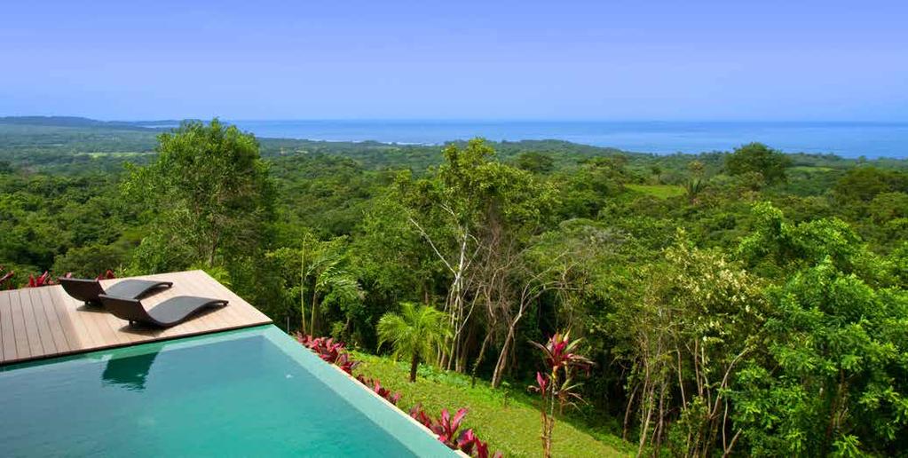
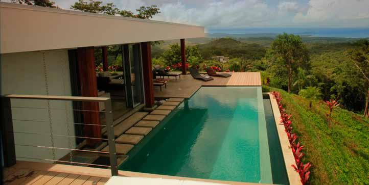
2 Adventure No limits, no boundaries, feed your sense of adventure. Nature Live in harmony with countless species of flora and fauna. Escape Unwind and unplug in complete solitude. Comfort & Convenience Living in comfort in sensible and sustainable modern villas. Brisas Pacíficas is a new eco-community located just minutes away from the friendly and bustling town of Golfito, Costa Rica. Conceived by Miami based developers Pablo Andrade and Javier Cruz, and designed by Fort Lauderdale based EcoPlan, Inc., Brisas Pacíficas is a small community of only 78 villas, a boutique hotel, equestrian facilities, nature trails, boat facilities and conservation areas. For every acre that will be platted, there is 1 acre that will be kept in conservation. Sensibly sized and sensibly designed sustainable villa homes are to be nestled into the landscape, between trees, with minimal impact. Over half of the villa home sites have world class unobstructed views to the town of Golfito, Golfito Bay, Golfo Dulce, the Pacific Ocean, Osa Peninsula and the mountains of southern Costa Rica. The remaining home sites are nestled on the edges of secondary and primary forests where the only neighbors you ll see are the Monkeys, Sloths, Coatis, Kinkajou, Quetzels, Trogons and Toucans. Every home site in Brisas Pacíficas will be a minimum of 5000 square meters (1.2 acres) to over 17,000 square meters (4.2 acres). These large home sites help minimize impact and facilitate a low density development that exists in harmony with nature. Introduction page 2


3 Location Brisas Pacíficas Golfito is located in the southern zone of Costa Rica in the province of Puntarenas. Golfito s small regional airport is only minutes away and is served by multiple daily flights on both Nature Air and TACA s regional carrier SANSA REGIONAL from San José. Flight times between Golfito and San José are approximately 50 minutes. Drive times between San José and Golfito are approximately 4 hours on Costa Rica s newly constructed Pan American Highway. Introduction - Location Map page 3


4 Location A third international airport serving the southern portions of Costa Rica and northern Panama is currently in the planning stages near Palmar Sur. The development of this airport will assure easy access to the Golfito area and Brisas Pacíficas from international destinations throughout the United States, Canada, Europe and Latin America. Drive times from Brisas Pacíficas to Palmar Sur is approximately 50 minutes. Introduction - Location Map page 4


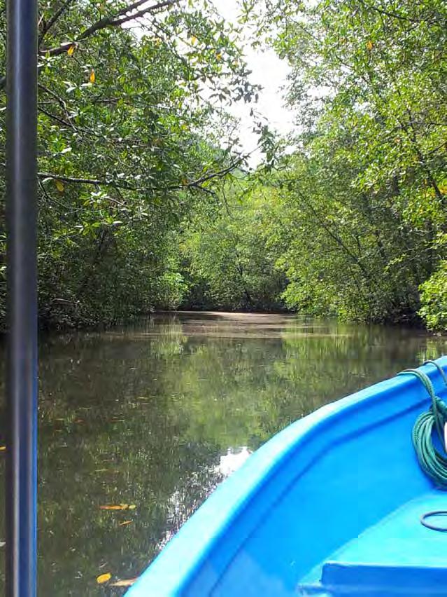
5 Location Golfito s regional airport is only 10km (6 miles) from Brisas Pacíficas. Arrival to the property from Golfito can be done by car which takes approximately 20 minutes. However, residents and visitors of Brisas Pacíficas will most likely choose to arrive via our private boat service, across the beautiful and always tranquil waters of Golfito Bay, arriving at the Brisas pier. Introduction - Location Map page 5


6 Golfito History The port town of Golfito was founded in the late 1930 s by the United Fruit Company, primarily for the processing and exportation of Bananas. Within a short time, Golfito was built into a prosperous trade center, bustling with activity and industry. At that time and into the 1980 s, Golfito was the most important port in southern Costa Rica. Due to declining market conditions, increase in taxes and a banana blight, the United Fruit Company pulled out of Golfito in 1985, and eventually an economic depression ensued throughout the area. The United Fruit Company eventually turned over all of their real estate holdings to the Costa Rican government. The following year, the Golfito Reserve, or Refugio National de Vida Silvestre was established as a National Park and Wildlife Refuge Area. In 1990, a duty free shopping zone was opened in Golfito attracting Costa Ricans from all over the country. That, combined with a thriving Eco-tourism industry developing around Goflito has revived the town and boosted the local economy. Introduction - Golfito page 6


7 Golfito Today Today, Golfito is once again a bustling community that has an established port economy for the exportation of Palm Oil, as well as an ever growing tourism industry. Tourists are treated to a variety of activities including world class sport fishing (both inshore and offshore), whale watching in Golfo Dulce, kayaking through the tranquil waters of Golfito Bay and nearby rivers, as well as a myriad of other eco-tourism activities that abound in the region. The community also boasts a variety of hotels and resorts, restaurants, bars, markets, and retail outlets allowing you access to services and goods. Medical facilities include a hospital in Golfito, as well as a future 224 room critical care hospital near Palmar Sur, which is planned as part of the new international airport. Introduction - Golfito page 7


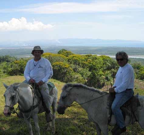
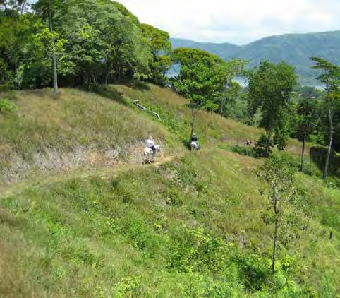
8 Adventure Whether it is touring the property on horseback, or exploring nearby waters and forests, the opportunities for adventure are limitless at Brisas Pacíficas. Adventure page 8


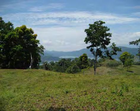
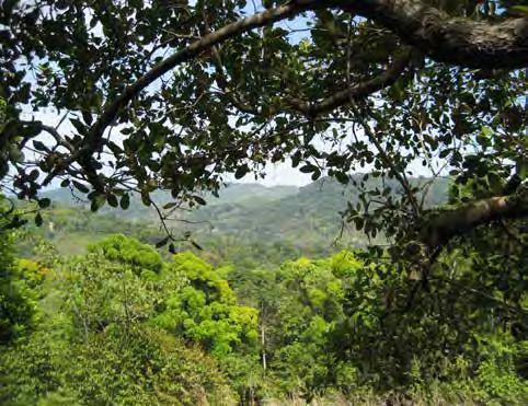
9 Nature Living in harmony with nature is a philosophy and way of life at Brisas Pacíficas. Both on site, at nearby national parks, nature preserves and in surrounding waters, opportunities to experience a rich, bio diverse landscape abound. Nature page 9


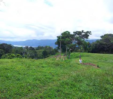
10 Escape Life at Brisas Pacíficas offers you the opportunity to easily escape, unplug and unwind. True wilderness is right out your back door, and the avenues towards solitude and reflection have never been as close and easy as they are here at Brisas Pacíficas. Escape page 10


11 Convenience With the town of Golfito only minutes away, you ll always have access to all of the essential needs of modern living, including transportation, health care, shopping, dining and entertainment. Comfort / Convenience page 11


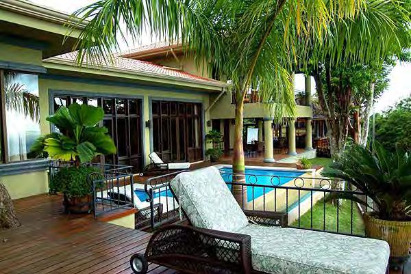
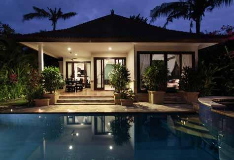
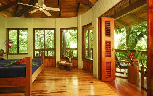
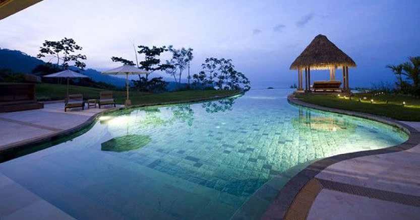
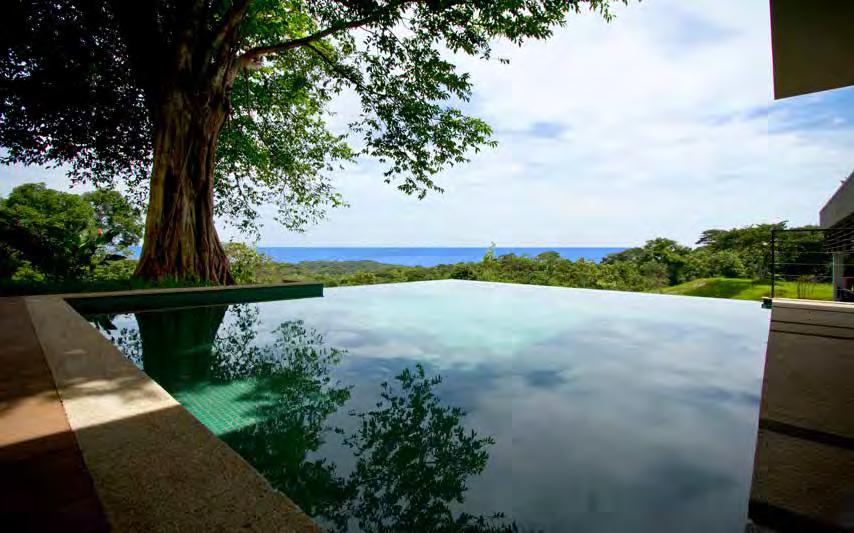
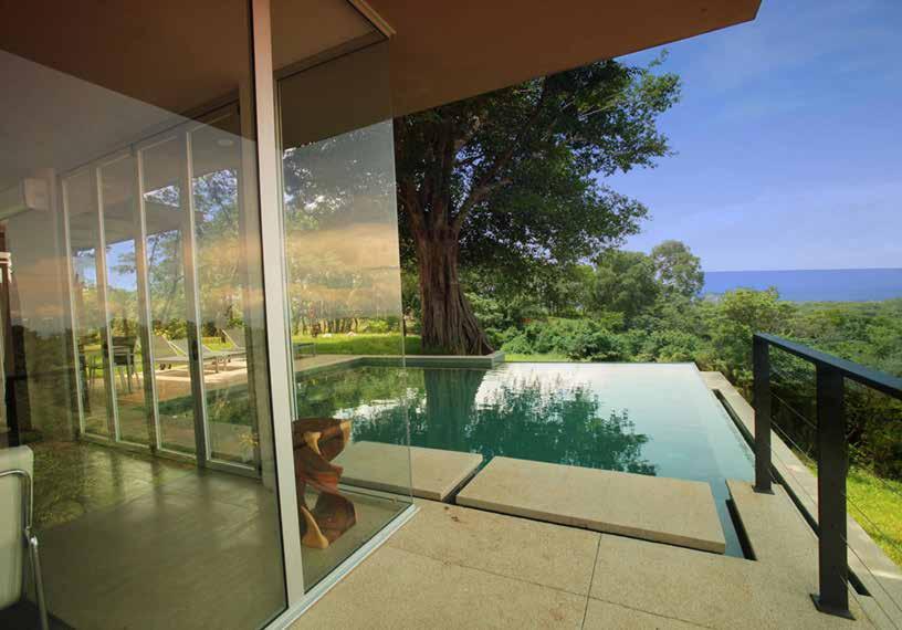
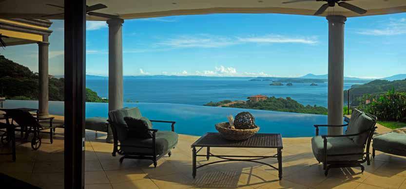
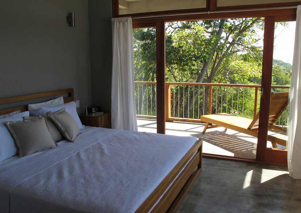
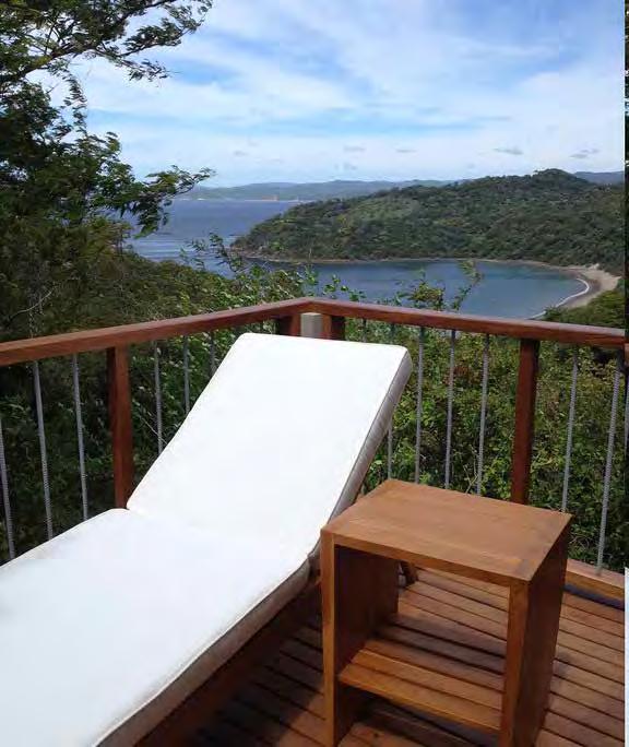
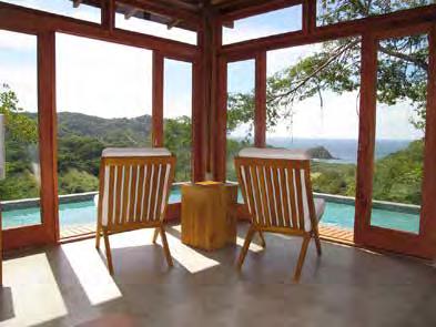
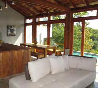
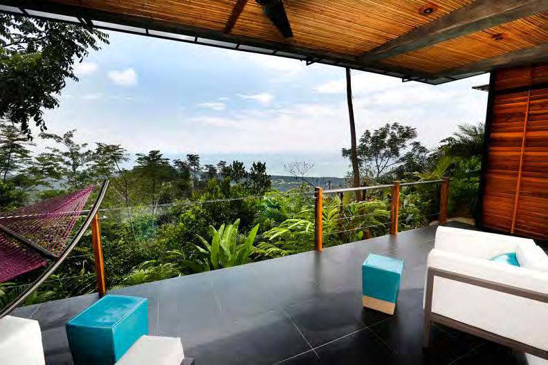
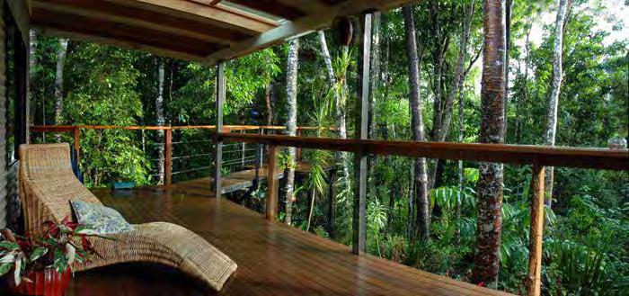
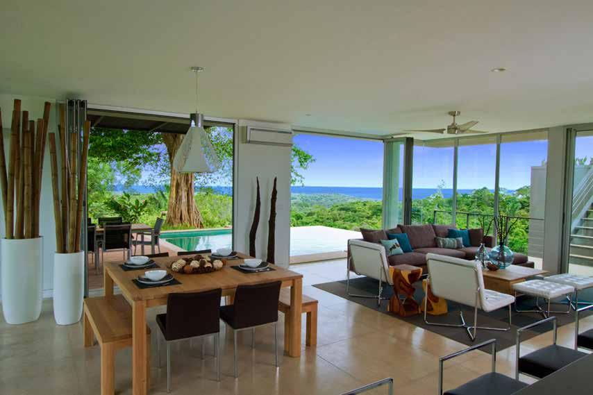
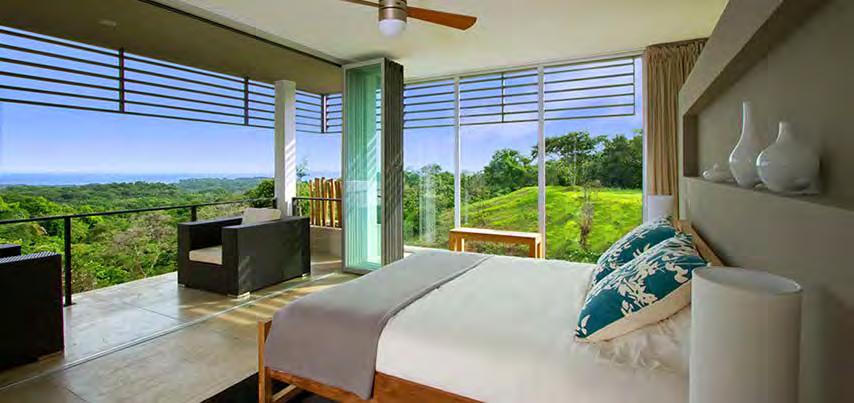
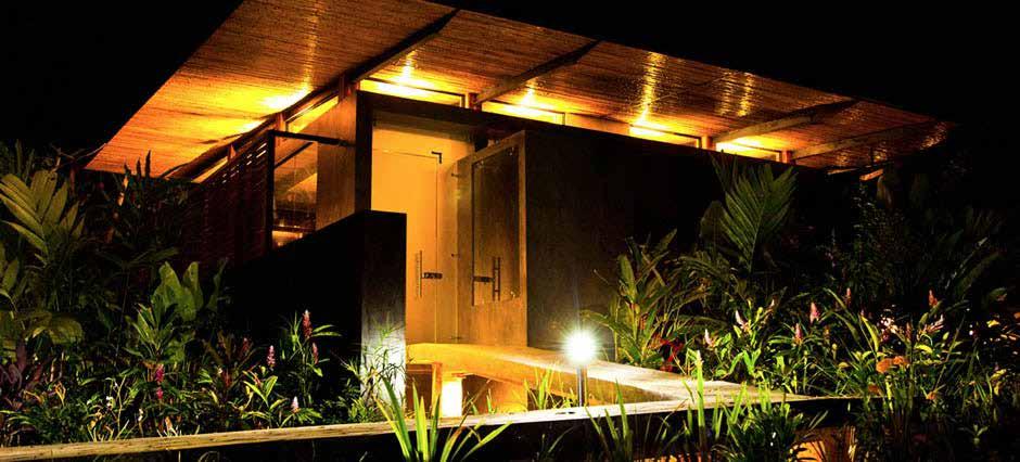
12 Arrival The approach by boat to Brisas Pacíficas from Golfito takes us across the tranquil waters of Golfito Bay, to the project s community dock facilities. This pier will be purposed as a point of embarkation for day tours for whale watching, river tours, kayaking, etc. Or, our private water taxi will take you to Golfito for dining, shopping, or drop you at your boat docked at one of the marina facilities in Golfito. Property Photographs page 12
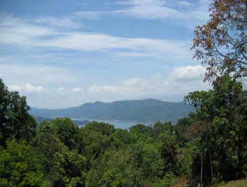

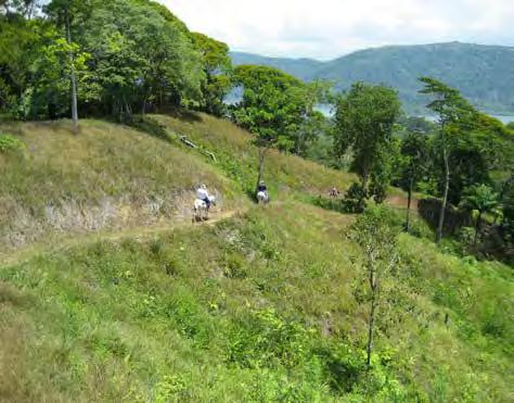
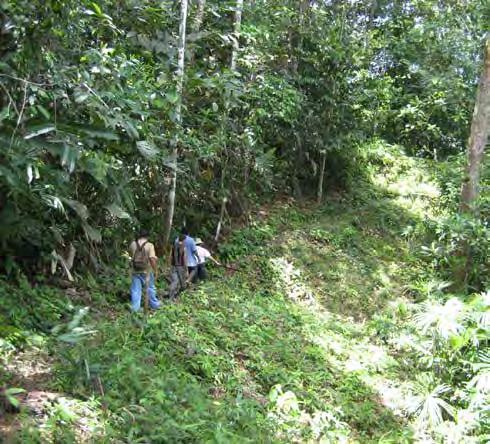
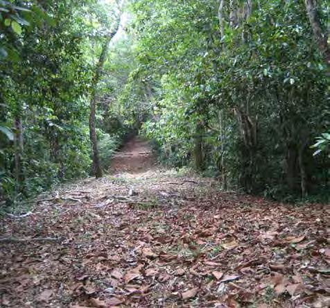
13 Property Photographs page 13
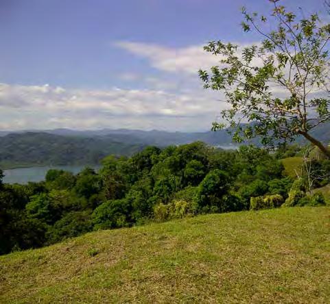
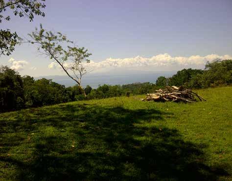
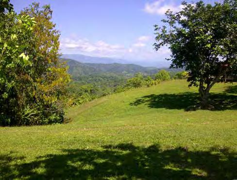
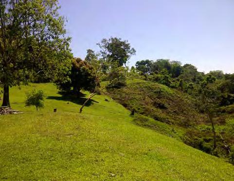
14 Property Photographs page 14

15 Property Photographs page 15

16 Property Photographs page 16

17 Property Photographs page 17
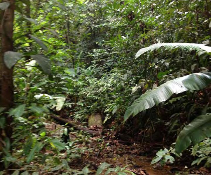
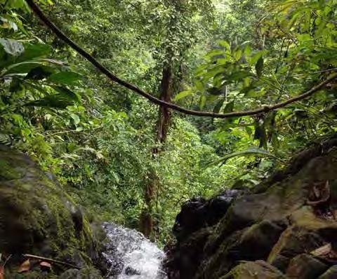
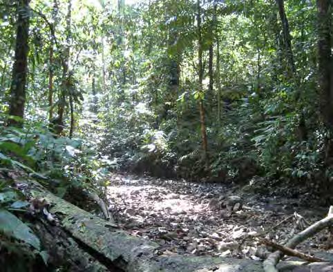
18 Property Photographs page 18

19 Property Photographs page 19

20 Site Analysis Prior to undergoing the planning and design process for Brisas Pacíficas, EcoPlan has thoroughly analyzed the existing conditions of the property to determine the opportunities and constraints of the site. A series of site analysis diagrams have been prepared to map items such as existing open areas, drainage corridors, slopes and elevations. These diagrams are overlaid with our concepts as we go through the design process, and help us as designers make decisions on how to utilize the land in the most efficient and sensitive manner possible. Site Analysis Open Areas and Drainage Corridors Diagram page 20

21 Elevation Analysis The elevation analysis map color codes the various elevation ranges from dark green which represent the lowest elevations (below 20m) to the highest elevations (above 220m). Visualizing the various elevation ranges allows us to determine the various watersheds and how land masses impact views from various locations within the property. Elevation Analysis page 21
22 Slope Analysis The slope analysis map color codes the severity of the slopes throughout the property. The degree of slopes range from light green (0-10% slopes) to dark brown (over 60% slopes). In order to prepare a design that is sensitive to the existing terrain and vegetation, the proposed development areas are concentrated on those portions of the site that are within the ranges of 0-40% slopes, with proposed construction in areas exceeding 40% slope held to an absolute minimum to reduce both the impact and the cost of development. Slope Analysis page 22

23 Aerial Overlay Overlaying the property boundary and topographic contours over the aerial photograph allows us to map existing forest and open areas, both on site and in adjacent areas. Additionally, the overlay allows us to trace view sheds to adjacent waterways to maximize views from the development areas of the project. Property Overlay on Aerial Photograph page 23
 Luxury Forest Cabins, accessed by electric cart and walking paths only to minimize impact on the existing terrain and vegetation. -Large 2.5Ha. Boutique Hotel Parcel.")
24 Concept 1 Highlights: -Portion of entry road moved off site to minimize construction of entry road in extreme slopes. -Small zone of (18) Luxury Estate Lots (5000 sq. mtrs. minimum). -(55) Luxury Forest Cabins, accessed by electric cart and walking paths only to minimize impact on the existing terrain and vegetation. -Large 2.5Ha. Boutique Hotel Parcel. -Minimal impact in sensitive tacotal forest areas. Units to be constructed between the trees. -Conservation areas throughout the property. Conceptual Land Use Plan Alternative 1 page 24
25 Concept 2 Highlights: -Maintain entry road on property in the event agreement could not be made with the adjacent property owner. -Large area of (63) Luxury Estate Lots (5000 sq. mtrs. minimum) -Large 2.5Ha. Boutique Hotel Parcel. -Minimal impact in sensitive tacotal forest areas. Units to be constructed between the trees. -Conservation areas throughout the property. Conceptual Land Use Plan Alternative 2 page 25
26 Concept 3 Highlights: -Portion of entry road moved off site to minimize construction of entry road in extreme slopes. -Zone of (42) Luxury Estate Lots (5000 sq. mtrs. minimum). -(6) Large Family Compounds -1.8Ha. Boutique Hotel Parcel at highest and most valuable piece of property. -Organic community farms. -Conservation areas throughout the property. Conceptual Land Use Plan Alternative 3 page 26
27 Concept 4 Highlights: -Portion of entry road moved off site to minimize construction of entry road in extreme slopes. -Rehabilitation and Wellness Destination with various therapy facilities including Weight Loss, Family Therapy, Team Building and Addition Rehab Facilities. -No residential or resort facilities -Minimal impact in sensitive tacotal forest areas. Units to be constructed between the trees. -Conservation areas throughout the property. Conceptual Land Use Plan Alternative 4 page 27
 Prime ocean view parcels for development / boutique hotels -(2) Multifamily development parcels -(25) Premium ocean view lots -(38) Forest view lots -(59) Tree house villas (zero impact")
28 Concept 5 Highlights: -Portion of entry road moved off site to minimize construction of entry road in extreme slopes. -(2) Prime ocean view parcels for development / boutique hotels -(2) Multifamily development parcels -(25) Premium ocean view lots -(38) Forest view lots -(59) Tree house villas (zero impact construction). -Conservation areas throughout. Conceptual Land Use Plan Alternative 5 page 28
 Key Boutique Hotel and Spa -(38) Premium Ocean View Lots -(68) Forest & Mountain View Lots -(38) Forest view lots -Equestrian facility and trails throughout.")
29 Preliminary Master Plan Highlights: -Portion of entry road moved off site to minimize construction of entry road in extreme slopes. -(36) Key Boutique Hotel and Spa -(38) Premium Ocean View Lots -(68) Forest & Mountain View Lots -(38) Forest view lots -Equestrian facility and trails throughout. -Conservation areas throughout. Preliminary Master Plan page 29

30 Master Plan This image of the Master Plan overlaid on the aerial photograph illustrates the connection to Golfito Bay where the community pier and boat dock will be located, as well as the roadway connection from the main property down to the waterfront. Golfito Bay Additionally, this overlay illustrates the relationship between Brisas Pacíficas and Golfo Dulce, as well as the adjacent and picturesque river / mangrove estuary system to the southwest of the property. Brisas Pacíficas Finally, this plan also shows the route of the access road coming into the property to the north and east of the project. Golfo Dulce Overall Master Plan and Surrounding Areas page 30
31 Master Plan -(36) Key Boutique Hotel and spa w/ Resident s Club access. -(78) Total Estate Lots of at least 5000 sq. mtrs. each. (31) of the lots have prime, ocean views, (47) have premium forest and mountain views. -Gated and Secured Access -Equestrian Club, Horse Stables, Paddocks and Pastures -Roadway connection to community pier / boat dock for private water taxi access to Golfito and day tours. -Network of scenic hiking paths, horse trails, and mountain biking trails throughout. -Forest waterfall natural swimming hole. Overall Master Plan page 31
 remote spa building with various treatment spaces. Access to all bungalows is via pathways and foot bridges.")
32 Boutique Hotel The Boutique Hotel at Brisas Pacíficas will include 30 keys in (14) remote single, duplex and triple bungalows, carefully built into the hillside to capture views to Golfito Bay and Golfo Dulce. There will be (1) remote spa building with various treatment spaces. Access to all bungalows is via pathways and foot bridges. Tree house like construction practices will be used to minimize impact. Gated Entry Boutique Hotel The main building is to include the resort core, with (6) standard rooms, restaurant, lounge, business center, meeting room and tour desk. This building may be constructed in the first phase to act as the community club facilities and lodge for prospective future residents. The boutique hotel property may be expanded by incorporating adjacent lots 1 through 4. Master Plan Enlargement - Boutique Hotel Area page 32

33 Golfito Bay Road and Community Boat Dock Primary access between Brisas Pacíficas and Golfito will be via private water taxi. Whether the trip is for shopping, dining, accessing your boat at one of Golfito s marinas, a trip to the airport or day tours, Brisas Pacíficas will have private water taxis to deliver you to and from Golfito. Equestrian Facilities and Helipad Nothing beats touring Brisas Pacíficas and surrounding areas by horseback. The community stables, paddocks and pasture areas will house a small compliment of horses for exploring the trails and conservation areas. A dedicated helipad will be provided in case of emergencies. Boat Dock / Pier Golfito Bay Access Road Equestrian Facility and Administration Facilities Helipad Entry Road Master Plan Enlargement - Golfito Bay Road and Equestrian Area page 33

34 Residential Areas Brisas Pacíficas will include a total of (78) large estate lots for sale. These lots range in size from 5000 square meters to over square meters. Although the lots are large, development of the lots will be mostly restricted to the building pads established by the developer, in the interest of preserving the existing terrain, trees and other vegetation. These larger lots help assure a low density feel and will reduce the overall impact on the land. The lots exist in a variety of conditions including open ridge tops with expansive panoramic views, forest edge lots with window views through the vegetation, and forest lots with open understory beneath the existing tree canopy. Master Plan Enlargement -Typical Residential Area page 34

35 Master Plan Enlargement -Typical Residential Area page 35

36 Master Plan Enlargement -Typical Residential Area page 36

37 Master Plan Enlargement -Typical Residential Area page 37


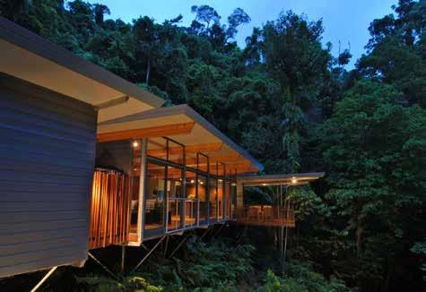
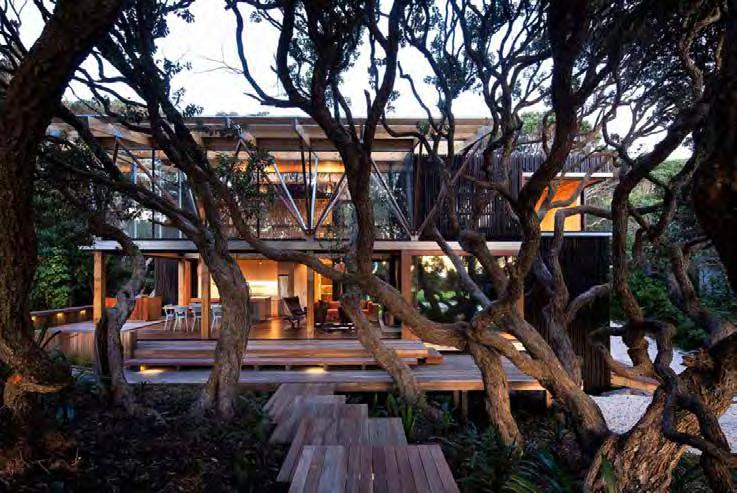
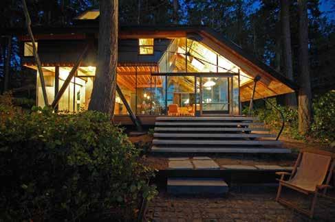
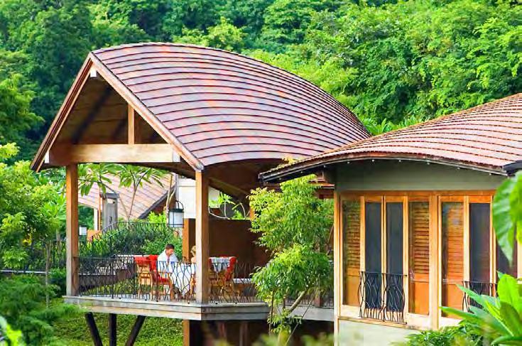
38 Architectural Inspiration The developers of Brisas Pacíficas will encourage the development of villas and a boutique hotel that is sensible in its scale and its integration into the existing landscape. The architectural character of historical Golfito should influence designers to extrapolate the historic themes of tropical design with the use of blended indoor / outdoor space, large overhangs and low pitched roofs that are built below the tree canopy. Materials and methods shall be sustainable and reflect the historic architectural character of the region. Architectural Character Images - Historic Inspiration page 38
39 Architectural Character Images page 39

40 Architectural Character Images page 40
41 Architectural Character Images page 41
42 Architectural Character Images page 42
43 Architectural Character Images page 43

44 Architectural Character Images - Boutique Hotel page 44

45 Architectural Character Images - Boutique Hotel page 45

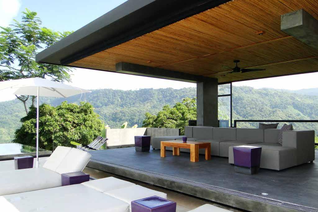
46 Architectural Character Images - Boutique Hotel page 46
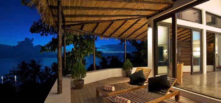
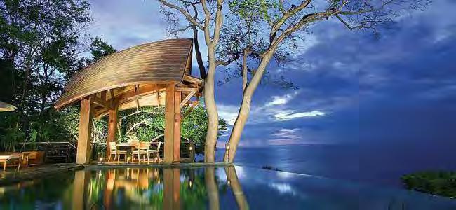
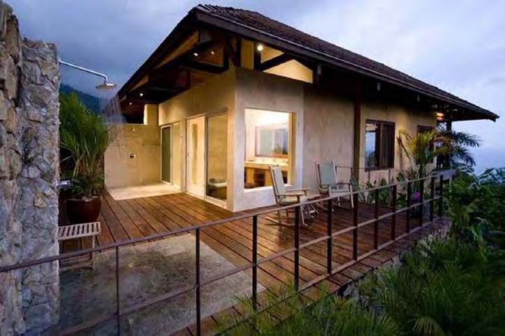
47 Architectural Character Images - Boutique Hotel page 47

48 Golfito Adventure Nature Escape Comfort page 48
Development Opportunity 10 Acres Mixed Commercial/Residential Permit in Place
 5595 E AST S OOKE R OAD G UIDE P RICE $ 449, 9 00 Development Opportunity 10 Acres Mixed Commercial/Residential Permit in Place Table of Contents The Property listing property assessment maps surveys property
4.1 AESTHETICS AND VISUAL QUALITY
 SCOPE AND METHODOLOGY 4.1 AESTHETICS AND VISUAL QUALITY This section evaluates the potential impacts to aesthetics and visual quality. Aesthetics refers to visual resources and the quality of what can
CY-FAIR ISD Exemplary-rated schools
 -ACRE master planned community GREEN SPACE within a quarter-mile of every home -SQ.FT. community center CY-FAIR ISD Exemplary-rated schools Located in Cypress, Texas, Bridgeland is northwest Houston s
ENVISIONING TOMORROW S FORT MYERS BEACH
 ENVISIONING TOMORROW S FORT MYERS BEACH NATURAL ENVIRONMENT... 2-1 MOBILITY... 2-1 TIMES SQUARE... 2-1 AVENUE OF PALMS... 2-2 RESIDENTIAL NEIGHBORHOODS... 2-2 A SECOND MAIN STREET... 2-4 FORT MYERS BEACH,
4 C OMMUNITY D ISTRICTS
 4 C OMMUNITY D ISTRICTS N ew development in the Area will include many different types of land uses, including a destination retail area that attracts people from all over the region; recreation opportunities
MARINA MARKET & WATERFRONT DEVELOPMENT STUDY PORT ARANSAS, TEXAS
 MARINA MARKET & WATERFRONT DEVELOPMENT STUDY PORT ARANSAS, TEXAS FEBRUARY 2015 PRESENTATION OUTLINE 1 2 3 4 5 6 7 REGIONAL POSITIONING SITE IMPRESSIONS PLANNING & DESIGN PRINCIPLES EXISTING IMPROVEMENTS
THREE-STEP DESIGN PROCESS FOR OPEN SPACE SUBDIVISIONS
 00216106.DOC NMA/RRK 1/30/14 THREE-STEP DESIGN PROCESS FOR OPEN SPACE SUBDIVISIONS Open space subdivisions, sometimes called cluster developments, maintain a significant portion of a development site in
Pioneering the Sustainable Future of Pakistan. A New Destination of Islamabad
 Pioneering the Sustainable Future of Pakistan A New Destination of Islamabad A New Destination of Islamabad C A P I TAL S M A R T CIT Y ISL A M A B A D, PAKISTA N CAPITAL SMART CITY ISLAMABAD C A P I TAL
Garden edges provide vertical plantings to buffer the neighbors from the building facilities around the entire campus.
 Open Space Existing Open Space Children s intends to maintain the landscape as a garden around the campus to help children heal while providing spaces for visitors, caregivers, staff and neighbors. Children
Small Area Plan. South Gateway
 Small Area Plan Adopted May 12, 2008 South Gateway Purpose. The South Gateway Small Area Plan defines the City s expectations for the future of the southern entrance to the City at Interstate 85 and Highway
Mendota Heights 2040 Comprehensive Plan Draft Vers
 4 Parks and Trails The City of Mendota Heights boasts a variety of recreational and open space opportunities. Few cities can claim access to regional trails, riverside and lakeside parks, scenic bluffs
Overlooking the Indian Ocean
 GRAHAM JOHN MAKE LIFE SPECIAL Overlooking the Indian Ocean T: 01303 474101 M: 07875 001499 E: mattryde@grahamjohn.co.uk www.grahamjohn.co.uk A stunning Garden Route home Focus on the views! Stunning accommodation
Please read the entire document
 projects impacting the waterfront revitalization area. The waterfront revitalization area of the town will have to subareas to the west and east of the village. Page 6 of 6 Wayfinding master plan create
Regional Context Statement
 Regional Context Statement REGIONAL CONTEXT STATEMENT 3. REGIONAL CONTEXT STATEMENT In 1995, the Provincial Government passed into law the Growth Strategies Act. The purpose of this provincial initiative
Notice of Preparation (NOP) of an Environmental Impact Report and Public Scoping Meeting for the Alameda Shipways Residential Project
 of an Environmental Impact Report and Public Scoping Meeting for the Alameda Shipways Residential Project") Notice of Preparation (NOP) of an Environmental Impact Report and Public Scoping Meeting for the Notice is hereby given that the City of Alameda, Lead Agency, will prepare an Environmental Impact Report
Notice of Preparation (NOP) of an Environmental Impact Report and Public Scoping Meeting for the Notice is hereby given that the City of Alameda, Lead Agency, will prepare an Environmental Impact Report
Village of Fair Haven Goals & Objectives
 Village of Fair Haven Goals & Objectives 1 Natural Environmental Quality & Aesthetics Embrace policies and programs that preserve and enhance the Village s natural resources, environment, water quality,
A private paradise. for a fortunate few
 A private paradise for a fortunate few Awaken to a breath of fresh air, transport yourself to a land of bliss, experience the realm of privilege As the antithesis of all things urban, PARADISE VILLAS presents
CY-FAIR ISD Exemplary-rated schools
 -ACRE master planned community GREEN SPACE within a quarter-mile of every home -SQ.FT. community center CY-FAIR ISD Exemplary-rated schools Located in Cypress, Texas, Bridgeland is northwest Houston s
PORT OF VANCOUVER WATERFRONT DEVELOPMENT. Concept Development Plan City Center Redevelopment Authority April 20, 2017
 PORT OF VANCOUVER WATERFRONT DEVELOPMENT Concept Development Plan City Center Redevelopment Authority April 20, 2017 Port History PORT ESTABLISHED 1912 TERMINAL 1 ACQUIRED 1925 GWM SIGNS LEASE 1935 HARBOR
Chapter 9: Economic Development
 Chapter 9 Economic Development Goal To embrace a stable, prosperous business environment focused on industry diversity, yielding family income sufficient to support education, recreation, social and cultural
City Center Neighborhood Plan
 [1] City Center Neighborhood Plan As adopted by Ordinance No. 2014-09-049 and amended by Ordinance Nos. Formerly CBD Neighborhood as adopted by Ordinance No. 8868 and amended by Ordinance Nos. 8946, 9693,
RIVERFRONT REDEVELOPMENT PLAN
 RIVERFRONT REDEVELOPMENT PLAN PROJECT BACKGROUND DEVELOPMENT OPPORTUNITIES This project strives to connect St. Francisville s downtown Historic District to the Mississippi River through river tourism,
Gruene River Place PDD CONCEPT PLAN AND DEVELOPMENT STANDARDS
 Gruene River Place PDD CONCEPT PLAN AND DEVELOPMENT STANDARDS GRUENE RIVER PLACE PLANNED DEVELOPMENT DISTRICT As per Section 3.5, Chapter 144 of the City s Zoning Ordinance To: The Planning & Zoning Commission
Offering Memorandum. Commercial Building. Market Square Properties, LLC (603) E. Main St., Cortez, Colorado, 81321
 E. Main St., Cortez, Colorado, 81321") Offering Memorandum Market Square Properties, LLC (603)-431-0400 mailbox@msprops.net Commercial Building Overview Investment Summary: This incredible investment opportunity is located at the heart of the
Offering Memorandum Market Square Properties, LLC (603)-431-0400 mailbox@msprops.net Commercial Building Overview Investment Summary: This incredible investment opportunity is located at the heart of the
Somers Point Master Plan
 Somers Point Master Plan Progress Report and Public Meeting August 20, 2014 Master Plan Reexamination Municipal Land Use Law require that all municipalities reexamine their master plan every ten years.
PREMIER BUILDING SITE
 VALLEY CENTER PREMIER BUILDING SITE PROPERTY REPORT ADDRESS: 15625 Rim of the Valley, Valley Center, CA 92082 DESCRIPTION: 10.56 ACRE premier building site located in the heart of San Diego County s avocado
The following principles guide the development of goals and strategies to protect and promote these amenities:
 OPEN SPACE/PARKS/TRAILS/RECREATION GOALS/STRATEGIES Cherry Hills Village is a living environment that offers low density development, open areas, public scenic vistas, public trails and public parks. This
CHAPTER FIVE COMMUNITY DESIGN
 CHAPTER FIVE COMMUNITY DESIGN CHAPTER FIVE - COMMUNITY DESIGN Assumptions Frazier Park and Lebec have historically developed according to different patterns of spatial form. While both communities are
Byway Beginnings: What s Your Story and How It Can Create Tourism. Sharon Liggett University of Georgia Archway Partnership
 Byway Beginnings: What s Your Story and How It Can Create Tourism Sharon Liggett University of Georgia Archway Partnership Summer Trips VA - Blue Ridge Parkway AL - Natchez Trace FL - Florida State Parks,
Conservatory Green, Stapleton s 8th great neighborhood.
 Conservatory Green, Stapleton s 8th great neighborhood. Rocky Mountain Arsenal National Wildlife Refuge Quebec St. Forward. LOOKING Dick s Sporting Goods Park School Stapleton s success over the years
WHO SAYS YOU CAN T HAVE IT ALL? marina.
 WHO SAYS YOU CAN T HAVE IT ALL? Gain a new perspective on waterfront living with Koi Residences and Marina a master-planned collection of waterfront villas, lofts, and condominium homes featuring resort-style
Chapter 4 Urban Design Element
 Chapter 4 Urban Design Element "The general tenor of the responses indicates a strong preference to not allow low-intensity development into natural areas, resource lands or highly visible open space.
M i s s i o n B a y W a t e r f r o n t
 114 M i s s i o n B a y W a t e r f r o n t Character of the Area: The Mission Bay Waterfront extends from Pier 48 at China Basin Channel to 18th Street in the Central Basin. This area of the waterfront
REGIONAL ACTIVITY CENTER
 DRAFT REGIONAL ACTIVITY CENTER 70 EAST BENCH MASTER PLAN DRAFT 06 Introduction The East Bench Regional Activity center is comprised of large educational, research, medical, and employment centers. These
The City shall enhance and improve the accessibility of parks and recreational facilities while protecting their quality. by:
 GOALS, OBJECTIVES AND POLICIES GOAL 1: To provide open space and recreation as an essential element needed for the betterment of the City s character and quality of urban life. The City shall plan for
Peppertree Business Park
 12.55 Net Acres Corporate/Institution Development Site PEPPERTREE BUSINESS PARK IS A UNIQUELY BEAUTIFUL MASTER PLANNED DEVELOPMENT SITE NESTLED AT THE FOOT OF THE SIMI HILLS WITH MEIER CREEK STREAMBED
Some thoughts for a sustainable tourism development strategy for Sanshui District of Foshan City
 Some thoughts for a sustainable tourism development strategy for Sanshui District of Foshan City Dr. Werner Breitung School of Geography and Planning Sun Yatsen University breitung@gmail.com [Prepared
Previous Stakeholder Meetings
 Titusville Tomorrow Previous Stakeholder Meetings Workshop 1 SWOT CVS Workshop 2 SWOT and CVS Results Value of Place Based Design 3 Table Top Designs The Waterfront The Gateways The Downtown Key Points
This Review Is Divided Into Two Phases:
 Semiahmoo Town Centre Review The purpose of this review: To review the Semiahmoo Town Centre Concept Plan, originally approved in 1993, to ensure that this centre will continue to serve the needs of South
SECTION IV: DEVELOPMENT CONCEPT
 80 SECTION IV: DEVELOPMENT CONCEPT Section IV: DEVELOPMENT CONEPT This section provides an overall understanding and rationale for what is envisioned in The Preserve, the intended quality and character
6 PORT SYDNEY SETTLEMENT AREA
 Section 6 Port Sydney Page 61 6 PORT SYDNEY SETTLEMENT AREA 6.1 Basis and Principles Village of Port Sydney Waterfront Community Existing Services 6.1.1 Port Sydney is an historic settlement that has developed
Call for Artists Deadline: April 27, 2018
 DOWNTOWN COMMONS NORTHWEST WALL and MAIN AVE. ELECTRICAL BOX WRAPS TWIN FALLS, IDAHO Call for Artists Deadline: April 27, 2018 INTRODUCTION The Magic Valley Arts Council on behalf of the City of Twin Falls
3.1 Existing Land Use
 3.0 Land Use This strategy has been developed taking into account the position of the Town of Sidney as the economic center of the Saanich Peninsula. It acknowledges existing land use patterns in the downtown
Heart of the Triad A Dynamic Plan for the Future. Steering and Technical Meeting April 27, 2006
 Heart of the Triad A Dynamic Plan for the Future Steering and Technical Meeting April 27, 2006 The Week in Review Specific Group Findings There Was Uniform Agreement the Time Was Right Growth is Imminent
THEMES, VISION, + PRINCIPLES
 CHAPTER 2: THEMES, VISION, + PRINCIPLES This page intentionally left blank. 20 VISION DRAFT AUGUST 2018 2 2 THEMES, VISION, + GUIDING PRINCIPLES The Key Themes, Vision, and Guiding Principles presented
11: Good Design - Boor Site
 Rural Design Workbook: 11: Site Introduction: A dairy and feed farm of over 450 acres in the town of Horseheads (Chemung County), David Boor s property has a number of notable features. The site is nearly
2.0 AREA PLANS. Lakeside Business District. Lakeside Business District Land Use Categories:
 Lakeside Business District Lakeside Business District Land Use Categories: Campus Commercial Campus Commercial means a mixture of uses which includes corporate offices, office parks, hotels, commercial,
CHONGMING ISLAND SHANGHAI CENTRAL CITY
 Chongming Island CHONGMING ISLAND SHANGHAI CENTRAL CITY Chongming Island Shanghai, China THE VISION: A GREEN ISLAND Chongming Island benefits from a magnificent setting, adjacency to the vibrant center
2.1 Location and Size
 2.0 Context 7 2.1 Location and Size The Saanich Penninsula The study area is centrally located within the Town boundaries on the east side of Highway 17, which runs through Sidney in a north-south direction.
Chapter 5: Recreation
 Chapter 5: Recreation Introduction and Setting Recreational opportunities within Nevada County are varied, ranging from public parks with intensively used active recreational facilities, to vast tracts
The Warehouse District in West Palm Beach is comprised of approximately 85,000 square of previously underutilized warehouse / industrial buildings in
 The Warehouse District in West Palm Beach is comprised of approximately 85,000 square of previously underutilized warehouse / industrial buildings in downtown being reimagined and redeveloped into a thriving
Green Infrastructure Policies and Ordinances
 Green Infrastructure Policies and Ordinances October 23, 2013 By Karen Firehock, Green Infrastructure Center 2013 Georgia Urban Forest Council s 23 rd Annual Conference The mission of the nonprofit Green
JULIAN HOME SITE PROPERTY REPORT
 ADDRESS: HWY 79, Julian, CA 92036 JULIAN HOME SITE PROPERTY REPORT DESCRIPTION: A rare 3.37+/- acre home site in the Kentwood area of Julian. This site is contiguous with Highway 79, but accessed via Lakeview
EL DORADO COUNTY GENERAL PLAN PARKS AND RECREATION ELEMENT PRINCIPLE INTRODUCTION STATE AUTHORIZATION
 EL DORADO COUNTY GENERAL PLAN PARKS AND RECREATION ELEMENT PRINCIPLE The General Plan must identify the types of governmental services, including parks and recreation facilities, which are necessary to
Conservation Development
 Acknowledgements RIDEM: Scott Millar Anthony Lachowicz-Planning and Zoning Consultant Director of Planning 1 : a creative land use technique that allows a community to guide growth to the most appropriate
25 Gleneagles Court. A charming cottage on the pond at Haig Point on Historic Daufuskie Island $285,000
 25 Gleneagles Court A charming cottage on the pond at Haig Point on Historic Daufuskie Island $285,000 Start your day with wonderful views from every room in the home. Watch the wildlife, including herons,
Goals & Objectives (best derived from an input
 Goals & Objectives (best derived from an input process) Goal - sets an intent of the project States the expected result or outcome of the project The trail will provide recreation and transportation opportunities
APPENDIX C. Architectural and Environmental Design Standards. Environmentally sensitive areas should be protected.
 APPENDIX C Architectural and Environmental Design Standards Environmentally Sensitive Areas Goal A. Environmentally sensitive areas should be protected. Development, such as roads, houses, and other structures,
Site Design (Table 2) Fact Sheet & Focus Questions:
 Fact Sheet & Focus Questions:") Site Design (Table 2) Fact Sheet & Focus Questions: BACKGROUND WHAT IS SITE DESIGN? Site design refers to the arrangement of buildings and open spaces on adjacent sites to maximize the shared benefits
Site Design (Table 2) Fact Sheet & Focus Questions: BACKGROUND WHAT IS SITE DESIGN? Site design refers to the arrangement of buildings and open spaces on adjacent sites to maximize the shared benefits
40 Years: A Brief History of Whistler - The Role of Long Term Planning Colorado Association of Ski Towns. January 20, 2016
 40 Years: A Brief History of Whistler - The Role of Long Term Planning Colorado Association of Ski Towns January 20, 2016 Presentation overview Whistler s unique history Building of Whistler Premise, purpose
Route 66 Business Corridor
 Route 66 Business Corridor DOWNTOWN BUSINESS AND CULTURAL DISTRICT SPECIFIC PLAN Draft April 2016 Acknowledgments Text Acknowledgments here etc... LIST NAME List List List Table of Contents 1. Introduction...
A. Selma Park, Davis Bay and Wilson Creek
 A. Selma Park, Davis Bay and Wilson Creek This waterfront neighbourhood consists of three separate community areas, linked by Highway 101, but with different character, land use patterns and future potential.
2. INTRODUCTION 2.1 AUTHORITY 2.2 PURPOSE AND INTENT 2.3 SITE LOCATION
 2. INTRODUCTION 2.1 AUTHORITY The City of Gardena initiated and prepared the Artesia Corridor Specific Plan pursuant to the provisions of California Government Code, Title 7, Division 1, Chapter 3, Article
A new French-Inspired Coastal Village on Scenic 30A
 A new French-Inspired Coastal Village on Scenic 30A Welcome to RidgeWalk RidgeWalk is a new gated French-Inspired Coastal Village of 74 home sites peacefully nestled among 19.5 acres of which 48% is untouched
City of Chickasaw Land Use Comprehensive Plan 2030 Chapter5-Draft(2)Public review_
Public review_") Land Use Land Use refers to the activity or development characteristics of a given parcel of land. The Land Use Plan presented in the following pages, represents the City of Chickasaw s official position
Land Use Land Use refers to the activity or development characteristics of a given parcel of land. The Land Use Plan presented in the following pages, represents the City of Chickasaw s official position
MARKETING PUBLIC RELATIONS AGENCY REQUEST FOR PROPOSAL FISCAL
 MARKETING PUBLIC RELATIONS AGENCY REQUEST FOR PROPOSAL FISCAL 2018-19 INTRODUCTION About Morro Bay This seaside fishing village with bustling waterfront offers a picture perfect getaway for individuals
3.0 LAND USE PLAN. 3.1 Regional Location. 3.2 Existing Conditions Existing Uses. Exhibit Regional Location Map
 3.0 LAND USE PLAN 3.1 Regional Location The Anaheim Resort Specific Plan (ARSP) area is located in the City of Anaheim, which is 35 miles southeast of downtown Los Angeles and 7 miles northwest of Santa
at Lakowe Lakes An exclusive sanctuary of only 18 villas... True Serenity.
 at Lakowe Lakes An exclusive sanctuary of only 18 villas... True Serenity. Content Introducing The Village About Lakowe Lakes About the course Aerial view at Lakowe Lakes Baobab - Bungalow Palm - Chalet-style
Master plan of Mulberry Hill, Hulical
 Master plan of Mulberry Hill, Hulical Attempts to bring residents closer to the pristine environs of the Hulical tea gardens exclusive gated layout amidst rolling tea estates. Mulberry Hill, Hulical blends
37 Interlaken A Vision To The Future
 37 Interlaken A Vision To The Future The History The Beckwith or Bonnie Briar Estate is one of the original Berkshires Cottages. It was built in 1892 and designed by architect and wealthy owner Leonard
Palm Jebel Ali - Dubai, United Arab Emirates
 Palm Jebel Ali - Dubai, United Arab Emirates LOCATION: CLIENT: Dubai Tony Perrin Senior Development Manager Dubai Waterfront Co LLC PROJECT SIZE: 1000 acres SCOPE OF WORK: Urban Design and Landscape Architecture
Town of Peru Comprehensive Plan Executive Summary
 Town of Peru Comprehensive Plan Executive Communities that plan grow by choice, not by chance. A plan makes growth thoughtful, understandable, and predictable. A plan shows that a community is managing
Highland Falls Waterfront Redevelopment Feasibility Study Village Board Meeting March 20, 2017
 Village Board Meeting March 20, 2017 Agenda I. Public Meeting #1 Visioning Summary II. Public Meeting #2 Comment Summary III. IV. IV. Case Study: Milton Train Station Schematic Design Concepts Schedule/Next
Eastern Terminus TECHNICAL MEMORANDUM CENTRAL BROWARD EAST-WEST TRANSIT ANALYSIS BROWARD COUNTY, FLORIDA
 Eastern Terminus TECHNICAL MEMORANDUM CENTRAL BROWARD EAST-WEST TRANSIT ANALYSIS BROWARD COUNTY, FLORIDA FINANCIAL PROJECT ID NUMBER 411189-2-22-01 FLORIDA DEPARTMENT OF TRANSPORTATION DISTRICT 4 Prepared
3 Summary of Major Views and Responses
 3 Summary of Major Views and Responses 3.1 Major Views 3.1.1 The comments and suggestions received from various channels and parties during the two-month Stage 1 PE on the Study, which have been discussed
Albert Lea. Redevelopment Plan. 701 Xenia Avenue South, Suite 300 Minneapolis, MN Tel: (763) Fax: (763) wsbeng.
 Fax: (763) wsbeng.") Albert Lea Redevelopment Plan 701 Xenia Avenue South, Suite 300 Minneapolis, MN 55416 Tel: (763) 541-4800 Fax: (763) 541-1700 wsbeng.com Albert Lea Redevelopment Plan Table of Contents Composite Districts...
Albert Lea Redevelopment Plan 701 Xenia Avenue South, Suite 300 Minneapolis, MN 55416 Tel: (763) 541-4800 Fax: (763) 541-1700 wsbeng.com Albert Lea Redevelopment Plan Table of Contents Composite Districts...
BURTON STATION STRATEGIC GROWTH AREA PLAN UPDATE PUBLIC MEETING 3/26/18
 BURTON STATION STRATEGIC GROWTH AREA PLAN UPDATE PUBLIC MEETING 3/26/18 1 WHERE WE ARE? 2 PRIMARY OBJECTIVES OF THE PLAN UPDATE 1. Update the land use designation for Burton Station Village to reflect
The transportation system in a community is an
 7 TRANSPORTATION The transportation system in a community is an important factor contributing to the quality of life of the residents. Without a sound transportation system to bring both goods and patrons
Affordability & Equity
 Affordability & Equity 1. Impact Fees 2. Displacement Prevention- build more housing to meet growth demands 3. Density Bonuses 4. Regional Housing Bond 5. Stricter Condominium Conversion Laws 6. Vacant
Pinellas County Greenways
 Pinellas County Greenways USING GREENWAYS TO LINK OPEN SPACES The Florida Greenways Commission has defined a greenway as...a corridor of protected open space that is managed for conservation and/or recreation.
CONSULTATION SUMMARY. Public and Online Consultation #1
 CONSULTATION SUMMARY Public and Online Consultation #1 On December 4, 2013 the Ministry of Tourism, Culture and Sport launched the first public consultation for the urban park and waterfront trail at Ontario
2 Collaboration Opportunities for Research and Exploration at Lakewood Ranch
 COLLABORATION OPPORTUNITIES FOR Collaboration RESEARCH Opportunities AND for Research EXPLORATION and Exploration at Lakewood Ranch 1 With research and innovation a key component of the growth in services
Master Plan Objectives and Policies
 Master Plan Objectives and Policies Introduction This chapter identifies the Park issues and recommended policies established by this Master Plan. The issues were identified through meetings with staff,
Costa Rica A Tour for Master Gardeners or anyone interested in nature. Tropical Horticulture and Nature. January 29 - February 7, 2015
 Costa Rica 2015 Tropical Horticulture and Nature A Tour for Master Gardeners or anyone interested in nature January 29 - February 7, 2015 LAND ONLY PACKAGE PRICE: $2,995 per person Airfare is not included
UPPER BRODHEAD CREEK PARADISE CREEK GREENWAY PLAN
 UPPER BRODHEAD CREEK PARADISE CREEK GREENWAY PLAN The Upper Brodhead & Paradise Creeks Greenway Cooperating Municipalities Mount Pocono Borough Paradise Township Barrett Township Price Township Funding
The impacts examined herein take into account two attributes of aesthetic values:
 IV. ENVIRONMENTAL IMPACT ANALYSIS This section addresses the potential impacts to views and aesthetics as a result of the proposed Project at the Project Site and the development scenarios analyzed for
Public Information Meeting
 Lavon Lake Master Plan Revision Public Information Meeting March 10, 2015 Presented By Michael Kinard Lake Manager U.S. Army Corps of Engineers Fort Worth District US Army Corps of Engineers Purpose of
DRAFT ROOSEVELT ROAD. District Recommendations. Figure 5.23 The Roosevelt Road Corridor
 CHAPTER 5 Figure 5.23 The Road Corridor Road will develop as a mixed-use corridor, emphasizing regional retail, west of the river and mixed-use development east of the river. KEY RECOMMENDATIONS 1. High
WELCOME TO ALDERLEY PARK
 WELCOME TO ALDERLEY PARK A unique location that brings together an illustrious past and stunning natural splendour. Alderley Park in the heart of the Cheshire countryside is a rare setting. Rarer still
Gardens of Ireland Small Group Tour. From $5,750 AUD. Gardens of Ireland Small Group Tour. 26 May 19 to 04 Jun 19
 From $5,750 AUD Single $6,650 AUD Twin share $5,750 AUD 10 days Duration British Isles Destination Level 1 - Introductory to Moderate Activity 26 May 19 to 04 Jun 19 This small group tour explores the
North Coast Retail Center Newly constructed Shopping Center in daily retail destination
 [ Conceptual Sprint Signage ] North Coast Retail Center Newly constructed Shopping Center in daily retail destination 1479 SE Discovery Lane, Warrenton, OR 97146 Featured Photos [ Conceptual Sprint Signage
Keyport. Vision for Keyport
 Keyport Vision for Keyport Keyport is a rural, historic waterfront village bounded and limited in size by its natural borders of water and the Naval Undersea Warfare Center. The community consists primarily
 Health Sciences City The available land area, although limited, combined with the unique partnership between the primary institutions and the supporting partnerships of the development interests within
... the real city lives on... Character Area 5: LOWER WASHINGTON
 ... the real city lives on... Character Area 5: LOWER WASHINGTON 89 Boundaries This area is bordered by the extension of Fair Way to the north, the Napa River to the south, Gerard Street/Fire Station parking
SECTION TWO: Urban Design Concepts
 SECTION TWO: Urban Design Concepts The Gardnerville Plan for Prosperity shapes economic opportunities presented by regional growth. The Urban Design Concepts provide policies and concepts for land use,
CHARLES PUTMAN CHARLES PUTMAN AND ASSOCIATES, INC
 MEMORANDUM CHARLES PUTMAN & ASSOCIATES, INC. LAND DEVELOPMENT CONSULTANTS PLANNING ZONING PERMITTING 4722 NW Boca Raton Boulevard, Suite C-106 Boca Raton, Florida 33431 Phone: 561/994-6411 FAX: 561/994-0447
Retail-Office Space For Lease
 Retail-Office Space For Lease 200-204 North Fifth Street, Mebane, NC Pedro J. Carreño Infinito Real Estate Group, L.L.C. pc@infinitoresources.com P.O. Box 2366 Chapel Hill, NC 27515 Tel: 516-967-5294 Infinitorealestate.com
Bourne Downtown Site Planning
 Prepared for: The Town of Bourne, MA In Cooperation with: Bourne Financial Development Corporation Prepared by:, Inc. June 24, 2009 Table of Contents Introduction and Summary... 1 Site Existing Conditions...
T O W N O F H I G H R I V E R
 T O W N O F H I G H R I V E R o p e n s p a c e p l a n The Town of High River, 30 minutes South of Calgary, still retains much of its distinctive small town character and provides residents with a high
EarthShare California
 EarthShare California Contact person: Tania Katbi, Director of Development Phone Number: (714) 386-0806 Email: tania@earthshareca.org Website: www.earthshareca.org How can you choose between drinking clean