FORMOSA GARDENS PD. PD Revised January 24,2013
|
|
|
- Ira Pierce
- 5 years ago
- Views:
Transcription


1


2
3 FORMOSA GARDENS PD PD Revised January 24,2013 Submitted to: Osceola County Community Development Department 1 Courthouse Square, Suite 1100 Kissimmee, FL Prepared for: Formosa Gardens Land Trust 7836 W. Irlo Bronson Memorial Hwy Kissimmee, FL Prepared by: Hanson, Walter & Associates, Inc. 400 W. Emmett Street Kissimmee, FL RECEIVED JAN Osceola County Planning Department
4 Table of Contents Section 1 Consulting Team Section 2 Maps and Plans General Location Map Master Plan Current Zoning Map Current Land use Map Pole Sign Location Area Map Section 3 Pre-Development Background and Site Inventory 3.1 General Location 3.2 Section, Township and Range 3.3 Pre-Development Access 3.4 Vegetation and Wetlands 3.5 Wildlife 3.6 Land Use Summary 3.7 Soils 3.8 Drainage, Flood Plains and Topography 3.9 Archaeological and Cultural Resources 3.10 Affidavit or Statement Regarding Existing Structures Section 4 Proposed Planned Development 4.1 Project Description 4.2 Proposed Development Program and Phasing 4.3 Summary of Proposed Land Uses Section 5 Provision of Community Services 5.1 Open Space 5.2 Recreation 5.3 Wastewater Collection 5.4 Water Distribution 5.5 Solid Waste 5.6 Police and Fire Protection 5.7 Stormwater Management 5.8 Utility Installation 5.9 Transportation/Roads 2
5 Section 6 Proposed Development Standards 6.1 Density Statement 6.2 Permitted Uses 6.3 Prohibited Uses 6.4 Development Standards 6.5 Building Restrictions 6.6 Parking 6.7 Buffers and Landscaping 6.8 Signage Section 7 Justification for Proposed Planned Development 7.1 Purpose 7.2 Identification of Requested Deviations from Standard Zoning 7.3 Satisfaction of LDC Objectives Section 8 Anticipated Neighborhood Impacts 8.1 Neighborhood Compatibility 8.2 Influence on Future Development Patterns 8.3 Influence on Neighboring Drainage 8.4 Alterations Proposed to Wetlands 8.5 Offsite Drainage Alterations Proposed 8.6 Impacts Anticipated to Topo and Vegetation 8.7 Impacts Anticipated to Wildlife 8.8 Impacts Anticipated on Population 3
6 Section 1- Development Consulting Team Applicant: Owner: Agent: Formosa Gardens Land Trust 7836 W. Irlo Bronson Memorial Highway Kissimmee, FL Business Telephone: Business Facsimile: Address: Formosa Gardens Land Trust 7836 W. Irlo Bronson Memorial Highway Kissimmee, FL Business Telephone: Business Facsimile: Address: Hanson, Walter and Associates, Inc. Attn.: Mr. Jim Urick 400 W Emmett Street Kissimmee, Florida Business Telephone: (407) Business Facsimile: (321) Surveyor and Civil Engineer: Hanson, Walter and Associates, Inc. Attn.: Mr. Randy Hanson (Surveyor) Attn: Mr. Larry Walter (Engineer) 400 W Emmett Street Kissimmee, Florida Business Telephone: (407) Business Facsimile: (321)
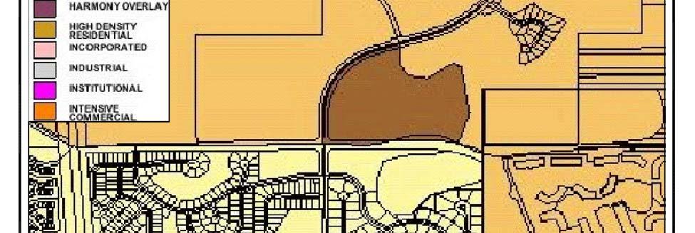
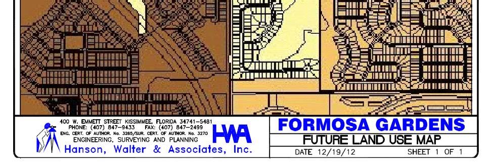
7 Section 2 - Maps and Plans Exhibit A: Architectural Entrance Feature for Formosa Gardens/ Splendid China Exhibit A-1: Entrance Feature Site Plan Exhibit B: Internal Directional Signs Exhibit BB: Billboard Exhibit BB-1: Billboard Location Map Exhibit C: Vehicular Control Signs Exhibit D: Street Sign Exhibit E: Light Pole Banners Exhibit F: Harley Davidson Exterior Exhibit F-1: Harley Davidson Exterior Exhibit F-2: Harley Davidson Pole Sign A Exhibit G: Formosa Gardens PD Site Development Plan Exhibit G.1.1: Entry Monuments Signs Exhibit H: Aerobar Sketch Exhibit I: Pole Sign Location Area Map Exhibit J: Highway 192 Sign Schedule Exhibit K: Equivalency Matrix Exhibit L: P.D. Master Plan Exhibit M: Zoning Map Exhibit N: Future Land Use Map Exhibit O: Location Map 5
8 Section 3 - Pre-Development Background and Site Inventory 3.1 General Location: The Formosa Gardens PD is an existing mixed use planned development consisting of approximately acres located in Osceola County. The property is South of U.S. 192 and east of S.R. 429 in Osceola County, Florida. 3.2 Section, Township and Range: The Formosa Gardens PD occupies a portion of Sections 3, 4, 9 and 10 in Township 25 South, Range 27 East, Osceola County, Florida. 3.3 Access: U.S. Highway 192 (SR 530) /West Irlo Bronson Memorial Highway fronts the site on the north and SR 429 on the west. Formosa Gardens Boulevard, a four-lane collector road running north and south between U.S. Highway 192 and Funie Steed Road divides the Formosa Gardens property. 3.4 Vegetation and Wetlands: Upland Vegetation: The site historically consisted of orange grove as well as wetlands. Wetlands: The property contains wetlands. Through the permitting process with the South Florida Water Management District as well as Osceola County, wetland mitigation, preservation and creation were required. Conservation Tracts including upland buffers were created and platted. Development is in compliance with all conditions of the South Florida Water Management District as well as Osceola County. 3.5 Wildlife: As a requirement of the approved Development Order from Osceola County, an off-site compensation agreement with Osceola County Land Trust has been executed. 3.6 Land Use Summary: Please refer to the Master Plan in the Exhibits section and the Proposed Land Use Summary Table in Section
9 3.7 Soils: According to the Natural Resource Conservation Service, there is no potential for subsidence of upland soils areas based on the characteristics of the predominant upland soil types present onsite. While limitations are described in the Soil Survey of Osceola County Area, Florida, the soils identified on the project site, as denoted on the Soils Classification Map, provided in Section 2 herein, are typical and can be easily used for the intended purposes through proper soil management utilizing standard construction methods to prevent wind and water soil erosions. 3.8 Drainage, Floodplains and Topography: According to the Flood Insurance Rate Map (FIRM), Community Panel Number C, dated November 20, 1996, the 100-year flood elevation has been determined to be NGVD. The areas of the project that are within the flood zone are delineated on the Topographic Map, provided in Section 2, herein. No increase in offsite flooding shall result from the Formosa Gardens PD. All drainage improvements shall be in accordance with the existing South Florida Water Management District permit and Osceola County Engineering Department regulations. 3.9 Archaeological and Cultural Resources: There are no cultural or historical resources known to occur onsite; therefore, development of this property will not impact significant archaeological or historical resources. In the event that such resources are encountered during the course of construction, the developer will comply with state law and immediately notify the FDHR and cease construction activity until the area of resource can be identified and the appropriate cultural surveys conducted Affidavit or Statement Regarding Existing Structures: The existing mixed use planned development is an ongoing project. Portions of this site have been developed. All existing structures are in good working order and maintained. No existing structures are proposed to be removed. 7
10 Section 4 - Proposed Planned Development 4.1 Project Description: This PD modification request is to establish development standards for the undeveloped portion of the property, as well as recognize the developed portion, and establish development standards based on the prior approved and constructed Engineering Improvement Plans. It is also requested to incorporate the previously approved sign standards, as well as request additional standards. This application will also request innovative landscape design features for future commercial and residential development by incorporating Florida Friendly elements. The Formosa Gardens PD is an approved planned development consisting of approximately acres designated as Tourist Commercial, Low and Medium Density Land Uses on the FLUM of Osceola County s Comprehensive Plan. Formosa Gardens is an approved DRI. This DRI utilizes a development matrix for transferring uses from tract to tract. It is the Applicant s desire to incorporate this matrix within this PD to better facilitate development in the future. This matrix is included in the Exhibits section. The uses and intensities approved within the existing DRI will remain unchanged, and introduce Institutional Use throughout the Formosa Gardens DRI and Master Plan. A copy of the Master Plan is provided in this application. With the incorporation of the above elements in this PD modification application, Comprehensive Development Plans will no longer be required for development. 8
11 4.2 Development Program DEVELOPMENT PROGRAM DEVELOPMENT SUMMARY TO DATE PARCEL USE PROGRAM USE PROGRAM A Hotel 251 Rooms SUB Hotel Rooms/Restaurant A Commercial 6,238 S.F. CU/SDP A Resort/Hotel 360 Rooms FS A Office 14,100 S.F. FS B Res/M-F 112 D.U. CDP Res/M-F D.U. C Commercial 117,385 S.F. SUB C Office 5,900 S.F. CDP 93-08, 94-59, 95-35, , , D Hotel 259 Rooms D Commercial. 86,642 S.F. CDP , EIP , LS , CDP E Res/S-F 20 D.U. PS FS F Commercial 141,935 S.F. F Hotel 360 Rooms G Res/M-F G Res/S-F G Commercial H Rec/Club 5,000 S.F. I Res/S-F 135 D.U. CDP SUB SUB J Res/S-F 192 D.U. CDP PS K Res/S-F 91 D.U. CDP SUB CDP L Res/S-F 95 D.U. CDP SUB CDP CDP PLAT M,N Res/S-F 32 D.U. CDP PLAT O Commercial 48,850 S.F. Q Commercial ****Institutional 152,250 S.F. 5,900 S.F. Office 20 RES/S-F DU 48 Res/S-F D.U. 87 Res/S-F D.U. 192 Res/S-F D.U. 91 Res/S-F D.U. 95 Res/S-F D.U. 32 Res/S-F D.U. Hotel Residential Single Family Residential Multi-Family (up to 120 units may be Time Share) Commercial Office Clubhouse/Recreation 1,230 rooms 565 units 396 units** 401,050 S.F. 20,000 S.F.*** 5,000 S.F. ** Up to 120 units may be Time Share *** Office uses may be permitted where Commercial uses are permitted ****Institutional Use will be utilized using the commercial development program entitlements and may be incorporated throughout the Formosa Gardens DRI Phasing may occur in any geographical order provided that each phase can function on its own with adequate infrastructure to support individual phases. 9
12 4.3 Summary of Proposed Land Uses: The following Table summarizes the proposes Land Use changes between the existing PD ( ) and the proposed PD ( ) Use Existing Development Program (PD ) Change in Development Program New Development Program (PD ) Commercial 401,050 s.f ,050 s.f. Hotel 1,230 rooms 0 1,230 rooms Single Family Residential 565 units 565 Units Multi-Family Residential * 396 units units Office ** 20,000 s.f. 0 20,000 s.f. Clubhouse/Recreation 5,000 s.f. 0 5,000 s.f. Institutional *** --- *** * Up to 120 units may be Timeshare ** Office uses may be permitted where Commercial uses are permitted *** Institutional uses may be incorporated throughout the Formosa Gardens DRI Future development within the Formosa Gardens DRI may be processed utilizing the Equivalency Matrix. Existing Development Program (PD ) New Development Program (PD ) Parcel Use Program Use Program A Hotel 251 Rooms Hotel 251 Rooms A Commercial 6,238 S.F. Commercial 6,238 S.F. A Resort/Hotel 360 Rooms A Office 14,100 S.F. B Res/M-F 112 D.U. Res/M-F 112 D.U. C Commercial 117,385 S.F. Commercial 117,385 S.F. C Office 5,900 S.F. D Hotel 259 Rooms Hotel 259 Rooms D Commercial 86,642 S.F. Commercial 86,642 S.F E Res/S-F 20 D.U. Res/S-F 20 D.U. F Commercial 141,935 S.F. Commercial 141,935 S.F. F Hotel 360 Rooms Hotel 360 Rooms G Res/M-F 284 Res/M-F -- G Res/S-F -- G Commercial -- H Rec/Club 5,000 S.F. Rec/Club 5,000 S.F. I Res/S-F 135 D.U. Res/S-F 135 D.U. J Res/S-F 192 D.U. Res/S-F 192 D.U. K Res/S-F 91 D.U. Res/S-F 91 D.U. L Res/S-F 95 D.U. Res/S-F 95 D.U. M,N Res/S-F 32 D.U. Res/S-F 32 D.U. O Commercial 48,850 S.F. Commercial 48,850 S.F. Q Commercial ***Institutional 10
13 5.1 Open Space (Required/Provided): Section 5 - Provision of Community Services Please refer to the approved Development Order as it relates to the required open space. As a requirement to the approved DRI, a Biennial Report is submitted for review and approval. 5.2 Recreation (Required/Provided): Please refer to the approved Development Order as it relates to the required recreation. As a requirement to the approved DRI, a Biennial Report is submitted for review and approval. 5.3 Wastewater Collection: The Toho Water Authority is the wastewater service provider for the proposed Formosa Gardens PD. With the construction of Formosa Gardens Unit 1, wastewater infrastructure was installed and cleared for use. 5.4 Water Distribution: The Toho Water Authority provides potable water service for the project from water lines within Formosa Gardens Boulevard. With the construction of Formosa Gardens Unit 1, the potable water infrastructure was installed and cleared for use. 5.5 Solid Waste: Solid Waste Disposal for the project is being provided by Osceola County. 5.6 Police and Fire Protection: The Osceola County Sheriff s Department will provide police protection. Fire Station 71 located at 8706 West Irlo Bronson Memorial Highway is providing fire protection. 5.7 Storm Water Management: The storm water systems are designed to meet all dimensional and technical criteria as set forth by the SFWMD, Reedy Creek Water Control District and Osceola County. A Master Conceptual Permit exists for the DRI as well as the PD. The permit number is S. Subsequent permit modifications have been submitted and approved for this site. Best Management Practices have been utilized in accordance with the required regulatory agencies to minimize any increase in run-off from the site and to minimize any degradation of water quality in the ultimate basin over that which occurred in the pre-development state. The existing permitted system will function similarly to the pre-development conditions (pre-post volume and flood plain compensation) and will treat the required water quality produced by this development as set forth by the current Master Conceptual Permit. 11
14 5.8 Utility Installation: With the exception of primary facilities providing service to the project, all utility lines, including telephone, cable, and electric lines, shall be installed underground. Large transformers shall be placed on the ground on pad mounts and enclosed or located in a vault. All such above ground facilities shall be screened with landscaping. 5.9 Transportation/Roads: The following is a list of major roadways through the Formosa Gardens DRI and their subsequent development standards: 1. Sand Hill [aka Formosa Gardens Blvd.] Road shall have right of way consistent with PB 7, PGS (Formosa Gardens Unit 1) with a driveway spacing of 440 ft.; Oak Island [aka Funie Steed] Road shall have a right of way consistent with PB 8, PG 37 (Formosa Gardens Unit 5) with a driveway spacing of 245 ft.; and U.S. Hwy 192 shall have a right of way 200 ft. with a driveway spacing of 660 ft.; the above requirements will be imposed on new development. 12
15 6.1 Density Statement: Section 6 - Proposed Development Standards This development is an approved DRI known as Formosa Gardens DRI. Density has been establish and approved within the approved DRI and Development Order. No overall density revisions are requested. Please note the density can be shifted between parcels by use of the development matrix that is currently approved. 6.2 Permitted Uses: This development is an approved DRI known as Formosa Gardens DRI. Permitted Uses have been establish and approved within the approved DRI and Development Order. Please refer to Section 4.2 for the Development Program. 6.3 Prohibited Uses: This development is an approved DRI known as Formosa Gardens DRI. Uses have been establish and approved within the approved DRI and Development Order. Please refer to section 4.2 for the Development Program. 6.4 Development Standards: Description Commercial Hotel Single Family Residential Office Multi Family Residential Minimum lot width N/A N/A 40 N/A N/A Maximum building height 5 Stories No 3 stories 5 stories 5 stories restriction Minimum lot area N/A N/A 4, s.f. N/A N/A Maximum impervious area Per approved master conceptual permit Permit # Min bldg s/b from Formosa Gardens Blvd. Minimum building setback from PD perimeter Minimum front yard setback for a/c portion of building Cell Tower* 13
16 Description Commercial Hotel Single Family Residential Office Multi Family Residential Minimum front yard setback for N/A N/A 10 N/A 10 covered front porch Minimum side yard setback for buildings, pools, patios, decks or ancillary structures Minimum rear yard setback for buildings, ancillary structures, and roofed patios or decks Minimum rear yard setbacks for pool N/A 5 edge Minimum distance between buildings ' Minimum setback for front entry garage N/A N/A 20 N/A 20 Cell Tower* *Cell Tower Development Standards: Maximum tower height: 200 feet Minimum setback from residential property line: 200 feet Minimum setback from conservation easement or tract line: 15 feet 1. Development Standards established through prior CDPs will remain effective. 2. In accordance with PD , the following special condition will apply: Individual residential building permits for Lots 1-20, Island Estates at Formosa Gardens PB 17, PG 177 shall address protective safety railing, fencing or other appropriate fall protection along the top of Parcel E retaining wall along Tract A, Lake Wilson and conservation areas. 6.5 Building / Lot Restrictions: This development is an approved DRI known as Formosa Gardens DRI. Density and intensities have been establish and approved within the approved DRI and Development Order. A Biennial Report is required to ensure this development is within the requirements of the Development Order. 6.6 Parking: Residential parking standards for single family detached units are consistent with parking requirements as outlined in the Land Development Code. Townhome parking shall be provided at the ratio of 1 space for each one-bedroom unit and 2 spaces for two bedroom or larger units. Parking requirements for Commercial as well as Office will meet or exceed the minimum requirements of the current Land Development Code. 14
17 6.7 Buffers and Landscaping Buffers: Conservation areas have been established with the platting of the property. All upland buffers are included within the platted conservation area. The property lines are considered the safe development line. Landscaping: Each developing area shall meet the minimum standards of the pertaining sections of the Osceola County Land Development Code as of the date of this document. If this Section does not address a particular need or situation, the default is that Osceola code. It is the objective of this Section to enhance the landscape on this project to the best use and best industry and cultural practice within the boundaries of each landscape of the areas. This Section offers alternative design ideas that will make the landscape more pleasing and thus the experience of the use the site more enjoyable. Special emphasis will be placed on the providing aesthetically pleasing landscape in buffers, vehicle use areas, and other hard site areas. Current best practices will be used to retain the natural character of the project site, reduce the ecological impact and improve the general quality of the experience. Use of landscape plants that low water needs will be prime design criteria Tree Canopy A. Objective shall be to develop the cooling effect of tree canopy and the visual screening of large vehicle use areas. B. Large Canopy trees shall be defined as any tree with a mature spread of more than 30 diameter. Palms shall be planted in clusters that achieve the same mature canopy as an Understory Tree. C. Canopy trees, understory trees and palms may be used in combination to achieve the minimum canopy coverage, but no greater than 25% of the total Canopy coverage Vehicle Use Areas A. Perimeter Parking (Sketch 1) 1. Clusters of Palms may be placed as a canopy development but no more than 25%. 2. Two Canopy Trees shall be placed for each 100. Trees may be placed in clusters along the length of the buffer but no closer than 25. No space of more than 75 may be left without a canopy tree. 15
18 3. For each 100 of parking buffer planting adjacent to ROW, 75% of shrubs shall be minimum average 30 high with 80% opacity. 25% of each 100 section of the buffer may have lower growing shrubs. These areas shall have minimum 18 high planting 36 o.c. and 30 high shrubs 60 o.c. directly behind the lower planting. If the lower planting is used, one understory tree or a clump of three palms shall be placed added to each 100 section. B. Interior Parking (Sketch 2) 1. Canopy Tree Islands are defined as those equaling the width of 2 parking spaces, minimum width 18, and the full length of the adjacent parking space. 2. One Canopy Tree Parking Island shall be placed per each 12 parking spaces along perimeter landscaped areas. One Canopy Tree, 4 Caliper, minimum, shall be placed in each of these parking island. Terminal end islands shall be minimum of 6 in width with shall have 1 Understory Tree. 3. For interior abutting rows of parking not abutting any perimeter, there are 2 options. 4. Place one Canopy Tree Parking Island per each 12 linear parking spaces. On the abutting row, one Canopy Tree island shall be placed alternating midway in the line of spaces. One Canopy Tree shall be placed in each island. 5. Place 10 x 10 Diamond shaped islands at the middle of the abutting rows. There shall be one Diamond Island per each 10 abutting (5 linear) parking spaces. One small Understory Tree or a cluster of three Palms shall be placed in each Diamond Island. One Canopy Tree Island with one Canopy tree shall be placed per each 20 spaces. 6. In all cases a terminal island shall be placed at the end of all rows of parking. Terminal islands shall be a combined Canopy Trees island and a minimum 6 wide island that. The Canopy Island area shall have a Canopy Tree and the 6 section of the terminal island shall have 1 Understory Tree or 3 Palms. 7. All Parking areas shall have a minimum of 1 shrub per each 2 parking spaces Commercial Buildings (Sketch 3) A. Front Façade 1. Planting between the R.O.W. and the building foundation shall be placed in such position that it reduces the impact of the mass of the building and provides a visual screen from the public R.O.W. This visual screen may be in the form of larger planting areas strategically placed to achieve this goal. This planting area does not have to be across the foundation and may be part of or in the same areas as larger parking islands, Canopy Tree Islands, etc. 16
19 Buildings may be placed directly adjacent to walk, but walks shall be increased to 10 in width Residential Areas A. Minimum Canopy Tree Coverage 1. Wetland areas, Retention Ponds and other unusable public areas may be subtracted from the gross site areas to define the net project area. 2. Trees shall be placed as Street Trees, on individual lots or in other useable public areas to achieve the minimum coverage. B. Street Trees 1. Street Trees perform the function of visually breaking up long stretches of homes and other buildings. If the area between the back of curb any public walks is less than 10 in width, Street Trees do not have to be placed in that area. If the trees are not in the public R.O.W. area, they will be placed in an adjacent lot within 10 of the walk. Trees shall be placed 1 tree per each Single Family and Duplex lots developed as adjacent lots shall have one Canopy Tree per each Townhomes and other attached homes a. Those with driveways and 20 building setback shall have one Canopy trees and one understory tree per each 100. b. Those that abut parking or with less than 10 building setback shall have two Canopy trees and one understory tree per each 100. Where space between walks and building is restricted, these trees may be placed in parking islands adjacent to the homes. 17
20 18
21 19
22 20
23 6.8 Signage: All elements for CDP are to be carried forward with the approval of this application. In addition to the previously approved standards, this application is requesting that pole signs be allowed along Formosa Gardens Boulevard commercial tracts. Pole Signs are to be limited along the right of way adjacent to the Formosa Gardens DRI property only from U.S. Highway 192 to Funie Steed. Road. The area is fast becoming a commercial corridor. Please refer to the attached Pole Sign Location Area Map depicting area for pole sign location. Recognizing that Formosa Gardens is a unique, large scale mixed used planned development (PMUD) owing to its geographic location, size and existing development, the purpose of this PD is to permit such signs that will protect values, enhance the character of the Formosa Gardens PMUD, protect the public safety and welfare, and support and compliment land use objectives while still permitting reasonable identification and advertising by professional, residential and commercial establishments. This PD shall prohibit signs that by their size, location, construction or manner of display, are not aesthetically pleasing, endanger the public safety or individuals, confuse, mislead, obstruct the vision necessary for traffic safety, or otherwise endanger public health, safety, or welfare. 1. Principal Features: 1.1 It is intended to complement Osceola County s Outdoor Advertising Ordinance by relating signage to the major characteristics of streets and area. This is accomplished by identifying approved signage for Formosa Gardens on the attached Sign Schedule. 1.2 This PD restricts the total sign area permissible per site. Any sign placed on land or on a building for the purpose of identification, direction, or for advertising a use conducted therein or thereupon shall be deemed accessory and incidental to such land, building or use. It is intended that the display or signs will be appropriate to such land, building or use, but not excessive completion and clutter among sign displays in their demand for public attention. 1.3 This PD shall not regulate: a. Building design; b. Official traffic or government signs; c. Signs which are not intended to be viewed from any street, road, highway, public or private pedestrian way; gravestones; religious plaques; the display of street numbers; or any display or improvement not defined herein as a sign. 2. General Requirements: All signage and graphics in Formosa Gardens will be governed by the following Design standards. All signage will be reviewed by the Developer and/or the Design Review Board prior to submitting to Osceola County for final approval to ensure the proposed designs meet the standards. Any signage not described herein but not expressly prohibited by these documents shall meet the standards of the current Osceola County Sign Ordinance. The attached Sign Schedule depicts the location of existing & proposed signage for the project. 21
24 3. Definitions: Banner Signs: Combination Sign: Copy Area (Sign face): Custom Street Signs: Electronic Message Center: Entry Monument: Ground Sign: Internal Directional Signs: On-site Sign: Off-site Sign: Subdivision or Development Identification Sign: Temporary signs either with or without frames, possessing characters, letters, illustrations or ornamentations applied to cloth, paper or fabric of any kind, which is intended to market a product or advertise an event. A sign which may contain more than one of the following; Subdivision Identification sign, On-site sign, Off-site sign(s), and/or Electronic Message Center. The total cumulative sign area for all signs which are supported by, and part of the same structure. Where two or more signs that share the same framing, trim or molding, said framing, molding or trim shall compute only once in calculating the Advertising Display Area. Similarly, for doubled faced signs, only one copy area shall be counted in calculating the adverting display area; providing, such sign does not have greater than 45 degree angle measured from the apex. If the angle is greater than 45 degree, each sign shall be counted separately. A permanent sign that displays the name(s) of a street(s). A sign comprised of independent light bulbs arranged in a lampbank controlled by a programmable computer. A landscape/architectural structure which contains a Subdivision Identification sign and may contain Off-site Identification sign(s). A sign structure which is independent of support from any building, and which is supported by structures or supports so that the bottom of the sign rests upon the ground. A sign which identifies amenities and/or uses which service the general public but are not located on the same parcel. A sign relating, in its subject matter, to commodities, accommodations, services or activities offered at the parcel on which the sign is located. Any sign upon which advertising material may be displayed to publicize business, organizations, goods, services or events that are not located on the same site as the sign. The term shall include Billboards. A sign which contains the name of the subdivision or development. 22
25 4. Guidelines: All parcels within the overall development shall be allowed sign identification in accordance with guidelines set forth by the Osceola County Outdoor Advertising Ordinance, including the following: A) Architectural Entrance Feature for the D.R.I. One (1) Entrance Feature identifying cultural theme park, consisting of two (2) traditional Chinese dragons holding a carved ring finished in antique bronze, measuring overall 24 6 height x 49 0 length x 8 0 width, with twosided sign measuring 6 6 O.W. x 5 6 O.H square feet (Exhibit A), located on platted median at Formosa Gardens Boulevard and U.S. Highway 192 (Exhibit A-1). B) Internal Directional Signs on Formosa Gardens Boulevard, Silk Road, Oak Island Road (aka Funie Steed Road) and Sand Hill Road, measuring 5 0 O.W. x 4 0 (20 square feet) within the project shall be placed on private property and only one shall be placed per entrance. (Exhibit B). C) Vehicular Regulatory Signs with standard Department of Transportation (DOT) in panels (faces), and custom poles in conformance with all other regulations set forth by Osceola County Public Works Department, including colors, sizes setbacks and heights. Additionally, the developer will provide all structures and maintain them in good condition (Exhibit C). D) Custom Street Signs with standard street name panels and custom poles will be allowed, subject to approval by Osceola County Public Works Department. The developer will provide all structures and maintain them in good condition (Exhibit D). E) Banners Two (2) banners measuring 2 6 O.W. x 5 0 O.H. (12.5 sq. ft. each) shall be allowed, mounted on brackets to existing light poles, within the development (Exhibit E). Banners will be used to announce themed cultural and seasonal events. F) Sign plan for the Orlando Harley Davidson Site (parcel # ) consists of six (6) walls signs and one (1) pole sign (Exhibits F, F-1 & F-2). 1) A 378 square feet pole sign (189 square feet on each side), Sign A, with an overall height of 50 feet, and is setback 35 feet from the right of way line of W. Irlo Bronson Memorial Highway. The sign will consist of a double sided trademark sign (114 sq. ft. per side) and an electric message center with a dimension of 5 feet by 15 feet (75 sq. ft.) on each side. This site will also include approximately 1,000 square feet of landscaping enhancements in the unpaved area adjacent to the sign. 2) A trademark wall sign of 114 square feet will be located on the front wall of the building along U.S ) A trademark sign of 71 sq. ft. will be located above the main entrance. 4) Historic painted lettering along the top portion of the building on three (3) sides. These letters are 21 tall. The historic detail is on the northerly (98 sq. ft.), easterly (168 sq. ft.) and southerly (98 sq. ft.) portions of the building. 23
26 5) The word Service (3.6 sq. ft.) is painted above the service entrance on the southerly side of the building 6) There is no lettering or signage on the northwest building face die to its visibility. G) Billboard Site on U.S. Hwy 192 (parcel ID # ) is an existing doublesided multiple vision billboards consisting of 672 sq. ft. approved via CDP94-75 (Exhibit BB). This PD is proposing to replace the mechanical multiple vision billboard with two (2) doublesided 11 x 22 LED displays for a total of 484 square feet. The LED displays will be placed on the existing supporting poles. If approved the hold times for the sign will comply with the FDOTs standards of 6 seconds (Exhibit BB-1 & Billboard Site Plan). H) The proposed Aerobar Sign (parcel ID # ) will be on the shade portion of the proposed Aerobar ride, which is approximately 114 in circumference and approximately 6 feet in height. This sign is unique in that it is part of the ride which will ascend to 180. The sign shall be allowed a combined surface area of one (1) sq. ft. of wall signage allowed per linear foot of business building length measured along any public or private use road. Business length will be based on the diameter of the ride. (Exhibit H) I) Pole Signs on Formosa Gardens Boulevard from US Hwy 192 to Funie Steed Road 1. Poles Signs will be limited to Commercial Parcels C, D, F, G and Q. Please refer to Pole Sign Location Area Map. (Exhibit I) 2. Maximum size of sixty-four (64) square feet except for a multi-tenant building or shopping center with a minimum size of 50,000 square feet, sign shall have a maximum size of one hundred (100) square feet. 3. All signs shall maintain a peripheral spacing of fifty (50) feet between sign structures. 4. Minimum setback of 10 feet from all property lines. 5. All setbacks shall be measured from the nearest part (leading edge) of the sign structure. 6. Maximum height of sign shall be 20 feet. 7. All signs with an overall height of over ten (10) feet shall have a minimum ground clearance of six (6) feet; where signs project over vehicular driving lanes, minimum ground clearance shall be thirteen feet, six inches (13.6 ). 8. All structural framework, except the pole or pylon, shall be concealed. 9. Tri-faced and cube signs shall have a maximum of thirty six (36) square feet per sign face. 10. Multiple vision signs shall be allowed. The individual sections which contain the advertising copy shall be rotated not less than once every four (4) seconds. 11. Within a multi-tenant building of a minimum size of 50,000 square feet, anchor tenants may be permitted signage in addition to the identification sign, as follows: a maximum of one (1) sign for any one business, maximum of two (2) signs per site; maximum size of thirty-two (32) square feet, ten feet height and 10 foot setbacks. Minimum peripheral spacing of signs shall be fifty (50) feet. 24
27 12. All signs proposed for Formosa Gardens Boulevard shall be landscaped at the base of the sign. The landscape area ratio to the sign copy area shall be 1:1. A landscape plan shall be submitted with any application for permitting for all signs within the Formosa Garden Boulevard corridor. The landscape area may include a combination of berming, groundcovers, and/or ornamental trees. The landscape area shall be irrigated and may include a maximum of 30% sodded area. Landscaping and irrigation plans must be submitted with the sign building permit application. J) Poles Signs on US Hwy Maximum size of four hundred (400) square feet. Maximum height of sign shall be fifty (50), with a minimum fifty (50) feet setback from D.O.T. right-of-way. 2. All signs shall maintain a peripheral spacing of fifty (50) feet between sign structures. 3. Minimum setback from side or rear property lines of ten (10). 4. All setbacks shall be measured from the nearest part (leading edge) of the sign structure. 5. Maximum height of sign shall be 50 feet. 6. All signs with an overall height of over ten (10) feet shall have a minimum ground clearance of six (6) feet; where signs project over vehicular driving lanes, minimum ground clearance shall be thirteen feet, six inches (13.6 ). 7. All structural framework, except the pole or pylon, shall be concealed. 8. Multiple vision signs shall be allowed. The individual sections which contain the advertising copy shall be rotated not less than once every four (4) seconds. 9. Tri-faced and cube signs shall have a maximum of two hundred (200) square feet per sign face and cube signs shall have a maximum of one hundred-fifty (150) square feet per sign face. 10. Within a multi-tenant building of a minimum size of 50,000 square feet, anchor tenants may be permitted signage in addition to the identification sign, as follows: a maximum of one (1) sign for any one business, maximum of two (2) signs per site; maximum size of thirty-two (32) square feet, ten (10) feet height and 10 foot setbacks. Minimum peripheral spacing of signs shall be fifty (50) feet. 11. All signs proposed for U.S. Highway 192 shall be landscaped at the base of the sign. The landscape area ratio to the sign copy area shall be 1:1. A landscape plan shall be submitted with any application for permitting for all signs within the Formosa Garden Boulevard corridor. The landscape area may include a combination of berming, groundcovers, and/or ornamental trees. The landscape area shall be irrigated and may include a maximum of 30% sodded area. Landscaping and irrigation plans must be submitted with the sign building permit application. Notes: Approval of CDP94-75 allowed the following signs in addition to the above. 25
28 Entry Monuments: G.1 and G.3 and Ground sign as shown in Exhibit G include Off-site Identification Signs. Signs G.1 & G.3 advertise Lots D, E, F, G, H, and O & N within the overall development. Exhibit G.1.1 is typical of the monument design and allocation of sign faces for the aforementioned lots. Each property (lot) owner will have an easement granting rights to their respective sign on the Entry Monuments, which will be recorded with final plats for the developed portions on the site in the Osceola County Records. One (1) sign structure that is either a pole sign or monument sign shall be permitted on each site which meets minimum development standards, located on a publically maintained road. Those sites with frontage in excess of 300 feet frontage shall be permitted two (2) signs; provided, however, only one of those signs may be a billboard. Where a site has frontage on more than one road and said roads are in different sign zones, signage shall be permitted based upon the sign zone where the sign is installed, except where two signs are allowed based on more than 300 ft. frontage. One sign must conform to size and height restrictions for qualifying road frontage. The second sign may not exceed sign criteria for road where installed. 26


29 27

30 28

31 29


32 30
33 31
34 32

35 33
36 34

37 35


38 36
39 37

40 38
41 39


42 40
43 41
44 42 EXHIBIT J
45 43 EXHIBIT J
46 44 EXHIBIT J
47 7.1 Purpose: Section 7 - Justification for Proposed Planned Development Amendment In accordance the Osceola County Land Development Code, it is in the interest of this proposal to implement flexible design guidelines that depart from conventional straight zoning standards in order to provide a fully integrated, quality development. Implementation of these guidelines will result in a more efficient utilization of the land together with an increased level of amenities as discussed in 7.3 below. 7.2 Identification of Requested Deviations from Standard Zoning: As allowed in of the Osceola County LDC, this Planned Development requests the following deviations (indicated in color) from standard zoning requests: Lot width and area Setbacks Lot coverage Structural height Requirement of two trees on fee-simple townhome lots Signage Parking Infrastructure Other 7.3 Satisfaction of LDC Objectives: As required under of the Osceola County Land Development Code, the specific objectives are satisfied by implementation of the deviations outlined above for the proposed development in the following manner: LDC objective speaks to preservation of natural features, threatened and endangered flora and fauna, and clustering of usable open space for recreation. The approved Development Order for the approved Formosa Gardens DRI states specific requirements. A Biennial Report required by the approved Development Order insures that the conditions are met LDC objective speaks to design sensitivity to natural topography, native upland or wetland vegetation, and the preservation of historical or cultural resources. A Development Program is included with the approved Formosa Gardens DRI which took into consideration the preservation of the aforementioned. With the approval of the master conceptual permit issued from the South Florida Water Management (permit # S), all wetland mitigation, creation and conservation areas have been delineated with the recording of record plats. Monitoring is ongoing as required by the District. This information is included with the required Biennial Report provided for the existing Formosa Gardens DRI. 45
48 7.3.3 LDC objective speaks to housing types and compatibility of neighborhood arrangements that provide for variety in home buying options. The Formosa Gardens PD provides for resort townhomes, single family detached as well as time share. All neighborhoods are within walking distance of a future recreation area as well as commercial. Water management ponds are designed to be open to the entire community LDC objective speaks to creativity in the proposed use of land relative to physical development. This item is satisfied through the DRI process LDC objective speaks to the establishment of criteria for inclusion of compatible associated uses to complement varied land uses within the development. Through the approval of the Formosa Gardens DRI and the current approved Development Order, the proposed, as well as existing uses vary from the approved development model; however, the equivalency matrix will be utilized In accordance with the LDC objective which addresses simplification of review procedure by provision of comprehensive, simultaneous review of land use, site impacts, development standards, public needs and requirements, and health and safety, this report outlines the planned elements of the proposed project in Section 4 herein; addresses public needs and requirements and provides for the health and safety of the public in Section 5 herein; discusses the impact of the proposed development in Section 8, herein; provides specific development standards in Section 6 herein LDC objective speaks to the utilization of clustering to reduce costs and promote efficient use of land. The approved Formosa Gardens DRI as well as the approved Development Order demonstrates this concept In accordance with LDC objective, provision of standards and phasing schedules to insure consistency of development to be requested in subsequent site plans, this planned development modification outlines specific development standards which will govern any ensuing site plans in Section 6 herein In accordance with LDC objective, provision of buffering and greenbelts within and bordering property, The approved DRI as well as Development Order satisfies this objective In accordance with LDC objective, integration of interconnected pedestrian and bicycle friendly improvements. The Formosa Gardens PD provides for an abundance of pedestrian walks, park trails, and neighborhood sidewalks which link common space facilities with neighborhoods. 46
49 Section 8 - Anticipated Neighborhood Impacts 8.1 Neighborhood Compatibility Compatibility with adjacent properties was studied and approved with the existing DRI and Development Order. 8.2 Influence on future development patterns The Formosa Gardens DRI is an existing development with approvals dating back to The surrounding property has developed as a tourist commercial as well as short term rental. The surrounding properties are compatible with this existing development. 8.3 Influence on Neighboring Drainage The subject site has been approved and permitted by the South Florida Water Management District. Permit # S 8.4 Alterations proposed to wetlands: All alterations to wetlands have been permitted and constructed. This information is reflected in the existing Biennial report for the Formosa Gardens DRI. 8.5 Offsite Drainage Alterations Proposed: No offsite drainage alterations are anticipated as necessary for the construction of the project. 8.6 Impacts Anticipated to Topo and Vegetation: A Development Program is included with the approved Formosa Gardens DRI which took into consideration the preservation of the aforementioned. Please refer to the Development Order approved by Osceola County and the approved Formosa Gardens DRI. As a requirement to the approved DRI, a Biennial Report is submitted to Osceola County for review and approval. 8.7 Impacts Anticipated to Wildlife Permitting for development of the undeveloped tracts will require site surveys to be performed and determine the scope of proposed impacts, if any. If applicable, one of the mitigation solutions prescribed by the FWCC will be utilized for impacts or takings. 8.8 Impacts Anticipated on Population This item is addressed in the approved Formosa Gardens DRI. 47


50 48
51 49


52 50

53 51
54 52
Narcoossee Roadway Corridor
 Community Meeting Narcoossee Roadway Corridor April 5, 2012 Meeting Agenda Purpose of Meeting Continuation of Study Update Process (Previous Meetings Oct. & Nov., 2011) Tonight s Objective Review Proposals
ARTICLE 6: Special and Planned Development Districts
 ARTICLE 6: Special and Planned Development Districts 6-10 Traditional Neighborhood Development (TND) District 6-10.10 Purpose and Intent The Traditional Neighborhood Development (TND) District provides
Mitchell Ranch South MPUD Application for Master Planned Unit Development Approval Project Narrative. Introduction
 Mitchell Ranch South MPUD Application for Master Planned Unit Development Approval Project Narrative Introduction Mitchell Ranch South is a proposed single family (detached) residential development on
KASPER. City of Georgetown, Texas PUD Planned Unit Development. December 30, 2015 Revised January 27, 2016
 KASPER City of Georgetown, Texas PUD Planned Unit Development December 30, 2015 Revised January 27, 2016 Applicant: Sentinel Land Company, LLC 4910 Campus Drive Newport Beach, CA Prepared by: SEC Planning
EXHIBIT B PROJECT NARRATIVE POULSBO MEADOWS
 EXHIBIT B PROJECT NARRATIVE POULSBO MEADOWS Name of Project: Poulsbo Meadows; A Planned Residential Development (PRD)/Plat Applicants Name: PBH Group LLC/Byron Harris PO Box 1010 Silverdale, WA 98038 Description
Application for Site Plan Review
 Application for Site Plan Review City of Pontiac Office of Land Use and Strategic Planning 47450 Woodward Ave, Pontiac, MI 48342 T: 248.758.2800 F: 248.758.2827 Property/Project Address: Sidwell Number:
Baumgarten MPUD. Exhibit 3 Evaluation Criteria
 Pursuant to LDC subsections 10.02.13 B, 10.02.08 F and Chapter 3 G. of the Administrative Code, staff s analysis and recommendation to the Planning Commission, and the Planning Commission s recommendation
 NOTES: 1.) THE BOGGY CREEK RD. AND SIMPSON RD. IMPROVEMENTS DEPICTED ON THIS PLAN ARE BASED ON RECORD CONSTRUCTION PLANS AND HAVE NOT BEEN SURVEYED. 2.) EXISTING RESIDENTIAL BUILDING STRUCTURES AND ANCILLARY
Landscaping Standards
 CHAPTER 29 ARTICLE 403 29.403 Landscaping Standards Purpose: The purpose of this section is to protect and promote the public health, safety and general welfare by requiring landscaping in relation to
Site Development Plan (SDP) Checklist
 Checklist") Development Services Department 100 N. Wilcox Street, Castle Rock CO 80104 303-660-1393 or CRGov.com Site Development Plan (SDP) Checklist A complete Site Development Plan (SDP) submittal will contain
Development Services Department 100 N. Wilcox Street, Castle Rock CO 80104 303-660-1393 or CRGov.com Site Development Plan (SDP) Checklist A complete Site Development Plan (SDP) submittal will contain
PLANNED UNIT DEVELOPMENT Date: April 5, 2018
 PLANNED UNIT DEVELOPMENT Date: April 5, 2018 DEVELOPMENT NAME SUBDIVISION NAME LOCATION Robert Myers Robert Myers 2955 and 2989 Dauphin Street (Southeast corner of Dauphin Street and Sage Avenue) CITY
SITE PLAN REVIEW APPLICATION AND CHECKLIST
 SITE PLAN REVIEW APPLICATION AND CHECKLIST PROJECT SUMMARY: Project Name: City/ETA Location: City ETA (Application fee & number of copies needed are based on location) Property Location (Legal Description
CITY OF ZEELAND PLANNING COMMISSION
 APPLICATION FOR SITE PLAN REVIEW AND SPECIAL LAND USE Date City Official App. Filing Fee Rec'd ($350) NOTE TO APPLICANT: Please submit this application for Site Plan Review along with twenty (20) copies
Improve the appearance of off-street parking areas, vehicular use areas, and property abutting public and private roads;
 Bedford Township, MI (Monroe Co.) 2012 http://library.municode.com/index.aspx?clientid=02123 400.1907 - Landscaping and screening. Se 1907. 1. Intent. Landscaping, greenbelts, and screening are necessary
Dwelling Units Max 12 dwelling units per acre/min 8 dwelling units per acre. Development Mix 80% non residential/20% residential
 13. OSTEEN LOCAL PLAN Background: The Osteen Local Plan area is located in southwest Volusia County along the SR 415 corridor between Lemon Bluff Road and Acorn Lake Road and includes 3,990 acres. The
Drexel, Barrell & Co.
 Drexel, Barrell & Co. December 21, 2018 Engineers/Surveyors Boulder Colorado Springs Greeley 3 South 7 th Street Colorado Springs, Colorado 80905-1501 719 260-0887 719 260-8352 Fax El Paso County Planning
PRELIMINARY CONDITIONAL USE SUBMITTAL CHECKLIST REQUIREMENTS
 This checklist must accompany your submittal as the cover page. CONDITIONAL USE Application Submittal Checklist for PRELIMINARY AND FINAL APPROVAL Per Winter Park Land Development Code Sec. 58-90 PRELIMINARY
AWH REPORT OF THE PLANNING AND DEVELOPMENT DEPARTMENT FOR APPLICATION FOR REZONING ORDINANCE TO PLANNED UNIT DEVELOPMENT
 AWH REPORT OF THE PLANNING AND DEVELOPMENT DEPARTMENT FOR APPLICATION FOR REZONING ORDINANCE TO PLANNED UNIT DEVELOPMENT MAY 8, 2014 The Planning and Development Department hereby forwards to the Planning
SITE PLAN REVIEW ITEMS - REFERENCE CHECKLIST
 City of Seminole 9199 113 th Street N. Seminole, FL 33772 Ph: (727) 392-1966 Fx: (727) 319-6583 SITE PLAN REVIEW ITEMS - REFERENCE CHECKLIST Note: This checklist is designed to aid designers in the review
The Ritz-Carlton, Paradise Valley
 The Ritz-Carlton, Paradise Valley 7000 E. Lincoln Drive Keys to Success Community Conversation II June 4, 2015 RITZ-CARLTON PARADISE VALLEY Town Council Study Session June 4, 2015 General Plan 2012 Land
4.500 Preston Road Overlay District
 Section 4.500 Preston Road Overlay District 2004 Zoning Ordinance 4.500 Preston Road Overlay District (ZC 98-29; Ordinance No. 98-9-12) 4.501 Purpose To provide appropriate design standards for the use
Drexel, Barrell & Co.
 Drexel, Barrell & Co. June 18, 2018 Engineers/Surveyors Boulder Colorado Springs Greeley 3 South 7 th Street Colorado Springs, Colorado 80905-1501 719 260-0887 719 260-8352 Fax El Paso County Planning
CHESAPEAKE LANDSCAPE ORDINANCE
 CHESAPEAKE LANDSCAPE ORDINANCE CONSERVATION PRESERVATION CZO 19-600 Effective October 16, 2008 BUFFER YARD C PARKING LOT REFORESTATION YEAR 1 REFORESTATION YEAR 4 BUFFER YARD F CBPA REFORESTATION Page
Asbury Chapel Subdivision Sketch Plan
 Asbury Chapel Subdivision Sketch Plan PART 1: PROJECT SUMMARY Applicant: NVR Inc. Project Size: +/- 76.13 acres Parcel Numbers: 02101112,02116101,02116112, 02116113 Current Zoning: Transitional Residential
ARTICLE V PLANNED UNIT DEVELOPMENT DISTRICT
 ARTICLE V PLANNED UNIT DEVELOPMENT DISTRICT A. Purpose and Objective The Planned Unit Development (PUD) procedure provides a flexible land use and design regulation through the use of performance criteria
BYLAW C A Bylaw of Rocky View County to amend Land Use Bylaw C
 BYLAW C-7720-2017 A Bylaw of Rocky View County to amend Land Use Bylaw C-4841-97. The Council of Rocky View County enacts as follows: PART 1 TITLE This Bylaw shall be known as Bylaw C-7720-2017. PART 2
The purpose of the requirements in this Article is to provide for landscaping and screening of parking and other outdoor areas that will:
 XIII. LANDSCAPING & SCREENING A. Purpose The purpose of the requirements in this Article is to provide for landscaping and screening of parking and other outdoor areas that will: 1. Protect residential
BUFFERS, TREE PROTECTION AND LANDSCAPING. Sec Purpose and Intent.
 ARTICLE 20 BUFFERS, TREE PROTECTION AND LANDSCAPING Sec. 20.1. Purpose and Intent. Trees improve air and water quality, reduce soil erosion, reduce noise and glare, provide habitat for desirable wildlife,
Supplemental Design Guidelines
 Supplemental Design Guidelines 65 SUPPLEMENTAL DESIGN GUIDELINES As a supplemental reference to the project, the following diagrams are included to illustrate the site planning approaches that were followed
CHAPTER ADDITIONAL REQUIREMENTS IN THE NC, NEIGHBORHOOD COMMERCIAL ZONE
 CITY OF MOSES LAKE MUNICIPAL CODE CHAPTER 18.31 ADDITIONAL REQUIREMENTS IN THE NC, NEIGHBORHOOD COMMERCIAL ZONE Sections: 18.31.010 Purpose 18.31.020 Minimum Lot Area 18.31.030 Setbacks 18.31.040 Maximum
IV. Development in the Rural Overlay District
 Intracoastal Waterway Route 17 Route 168 Great Dismal Swamp VIRGINIA NORTH CAROLINA IV. Development in the Rural Overlay District IV-1 Route 17 in Chesapeake s Rural Overlay District affords distant views
SECTION UNIFIED DEVELOPMENT ORDINANCE SECTION Part 1 Ordinance. ARTICLE 1 Zoning Districts
 SECTION 1-100 UNIFIED DEVELOPMENT ORDINANCE SECTION 1-300 Part 1 Ordinance SECTION 1-100. Introduction. ARTICLE 1 Zoning Districts Crystal Lake strives to maintain a balance of various land uses for a
ZONING ORDINANCE FOR THE ZONED UNINCORPORATED AREAS ARTICLE 1150 OF PUTNAM COUNTY, WEST VIRGINIA Page 95 ARTICLE 1150 SITE PLAN REVIEW
 OF PUTNAM COUNTY, WEST VIRGINIA Page 95 1150.01 PURPOSE 1150.02 APPLICABILITY 1150.03 APPLICATION PROCESS 1150.04 REVIEW PROCESS 1150.05 REVIEW CRITERIA 1150.06 SITE PLAN GUIDELINES 1150.01 PURPOSE ARTICLE
Master Land Use Plan Application
 Development Review Division Development Services Department CITY OF OVIEDO 400 Alexandria Boulevard Oviedo, Florida 32765 Application No. Date Received Phone: (407) 971-5775 Fax: (407) 971-5819 www.cityofoviedo.net
Gold Line Bus Rapid Transit Transit Oriented Development (BRTOD) Helmo Station Area Plan
 Helmo Station Area Plan") Appendix F Gold Line Bus Rapid Transit Transit Oriented Development (BRTOD) Helmo Station Area Plan Introduction and Purpose of the Plan The Gold Line Bus Rapid Transit facility is an eleven-mile dedicated
Appendix F Gold Line Bus Rapid Transit Transit Oriented Development (BRTOD) Helmo Station Area Plan Introduction and Purpose of the Plan The Gold Line Bus Rapid Transit facility is an eleven-mile dedicated
LANDSCAPE ORDINANCE PASADENA PLANNING DEPARTMENT (713) FAX (713)
 FAX (713)") LANDSCAPE ORDINANCE PASADENA PLANNING DEPARTMENT (713) 475-5543 FAX (713) 477-1072 ARTICLE X. LANDSCAPING OF NONRESIDENTIAL SITES* Sec. 9-195. Applicability. (a) This article shall apply to the following:
LANDSCAPE ORDINANCE PASADENA PLANNING DEPARTMENT (713) 475-5543 FAX (713) 477-1072 ARTICLE X. LANDSCAPING OF NONRESIDENTIAL SITES* Sec. 9-195. Applicability. (a) This article shall apply to the following:
5.1.1 The streetscape along US Highway 64 (Brevard Road); and, The built environment within new residential developments; and,
; and, The built environment within new residential developments; and,") Article 5. Landscaping 5.1 Purpose The Town of Laurel Park s landscape standards are designed to create a beautiful, aesthetically pleasing built environment that will complement and enhance community
Article 5. Landscaping 5.1 Purpose The Town of Laurel Park s landscape standards are designed to create a beautiful, aesthetically pleasing built environment that will complement and enhance community
RECREATION AND OPEN SPACE ELEMENT GOALS, OBJECTIVES, AND POLICIES
 RECREATION AND OPEN SPACE ELEMENT GOALS, OBJECTIVES, AND POLICIES Goal 7 To provide park facilities, recreation programs, and open space resources that are safe, adequate, and accessible to all City residents,
ARTICLE IV: DEVELOPMENT STANDARDS 404 MASTER PLANNING
 IV 13 404 MASTER PLANNING Master Planning through the Site Analysis (Master Planning Site Analysis) or Planned Development (Master Planning Planned Development) is provided to encourage development which
MIXED-USE VILLAGE OVERLAY FLOATING DISTRICT
 MIXED-USE VILLAGE OVERLAY FLOATING DISTRICT Zoning regulations developed by committee to the Planning Board for the Town of DeWitt, NY Issue date: 13 July 2017 revised 3/12/2018, revised 4/26/2018, 5/9/2018
Section 511: 11 th Street Overlay District 1. Intent: 11 th Street is the primary entrance route into the city from the south, providing direct
 Section 511: 11 th Street Overlay District 1. Intent: 11 th Street is the primary entrance route into the city from the south, providing direct access from US Highway 12. As such, the community has identified
CHAPTER FIVE COMMUNITY DESIGN
 CHAPTER FIVE COMMUNITY DESIGN CHAPTER FIVE - COMMUNITY DESIGN Assumptions Frazier Park and Lebec have historically developed according to different patterns of spatial form. While both communities are
CITY PLANNING COMMISSION AGENDA. ITEM NO(s): C.1 C.3 STAFF: STEVE TUCK
: C.1 C.3 STAFF: STEVE TUCK") Page 34 CITY PLANNING COMMISSION AGENDA ITEM NO(s): C.1 C.3 STAFF: STEVE TUCK FILE NOS: CPC ZC 12-00035 QUASI-JUDICIAL CPC NV 12-00036 QUASI-JUDICIAL AR DP 12-00039 QUASI-JUDICIAL PROJECT: APPLICANT: OWNER:
Page 34 CITY PLANNING COMMISSION AGENDA ITEM NO(s): C.1 C.3 STAFF: STEVE TUCK FILE NOS: CPC ZC 12-00035 QUASI-JUDICIAL CPC NV 12-00036 QUASI-JUDICIAL AR DP 12-00039 QUASI-JUDICIAL PROJECT: APPLICANT: OWNER:
Exhibit A. 8:9 Scuffletown Rural Conservation District
 Exhibit A 8:9 Scuffletown Rural Conservation District 8:9.1 Intent and Purpose The Scuffletown Rural Conservation (SRC) District is intended to provide for residential development that supports the development
Planned Residential Neighborhoods Land Use Goals
 Planned Residential Neighborhoods Land Use Goals Issue: Guidelines that provide for diverse high quality residential areas that include a variety of housing styles and layouts are needed. Goal 1: Create
ARTICLE 3 LANDSCAPING AND SCREENING REQUIREMENTS
 ARTICLE 3 CHAPTER 4 LANDSCAPING AND SCREENING REQUIREMENTS SEC 3.401 SEC 3.402 (D) (E) PURPOSE: The purpose of this Chapter is to establish minimum standards for the design, installation, and maintenance
CHAPTER 26 LANDSCAPING (Chapter added in its entirety 05-08)
") CHAPTER 26 LANDSCAPING (Chapter added in its entirety 05-08) 26.01 DESCRIPTION AND PURPOSE. Landscaping is an important element of the use, development and preservation of land, and a significant factor
CHAPTER 26 LANDSCAPING (Chapter added in its entirety 05-08) 26.01 DESCRIPTION AND PURPOSE. Landscaping is an important element of the use, development and preservation of land, and a significant factor
SECTION II SECTION II STATEMENT OF GOALS, OBJECTIVES, PRINCIPLES, ASSUMPTIONS, POLICIES AND STANDARDS
 STATEMENT OF GOALS, OBJECTIVES, PRINCIPLES, ASSUMPTIONS, POLICIES AND STANDARDS 1 2 STATEMENT OF GOALS, OBJECTIVES, PRINCIPLES, ASSUMPTIONS, POLICIES AND STANDARDS INTRODUCTION The New Jersey Municipal
ARTICLE VI LANDSCAPE REQUIREMENTS
 ARTICLE VI LANDSCAPE REQUIREMENTS 6.0 Landscaping and Screening. 6.1 Purpose. The landscaping and screening requirements specified herein are intended to foster aesthetically pleasing development which
A BILL FOR AN ORDINANCE TO AMEND CHAPTER 9, KAUAI COUNTY CODE 1987, RELATING TO STREET REQUIRE:MENTS FOR SUBDIVISIONS
 ORDINANCE NO. BILL NO. { vy"yj1j A BILL FOR AN ORDINANCE TO AMEND CHAPTER 9, KAUAI COUNTY CODE 1987, RELATING TO STREET REQUIRE:MENTS FOR SUBDIVISIONS BE IT ORDAINED BY THE COUNCIL OF THE COUNTY OF KAUA'I,
CITY OF INVER GROVE HEIGHTS 8150 Barbara Avenue Inver Grove Heights, MN (651) Fax: (651)
 Fax: (651)") CITY OF INVER GROVE HEIGHTS 8150 Barbara Avenue Inver Grove Heights, MN 55077 (651) 450-2545 Fax: (651) 450-2502 www.invergroveheights.org SKETCH PLAN REVIEW APPLICATION FOR THE NORTHWEST AREA OVERLAY
CITY OF INVER GROVE HEIGHTS 8150 Barbara Avenue Inver Grove Heights, MN 55077 (651) 450-2545 Fax: (651) 450-2502 www.invergroveheights.org SKETCH PLAN REVIEW APPLICATION FOR THE NORTHWEST AREA OVERLAY
MIDTOWN MIXED-USE VILLAGE. TECHNICAL DATA SHEET COMPONENT C-1 FOR PUBLIC HEARING - PETITION NUMBER Project No RZ1.1. Issued.
 N MIDTOWN MIXED-USE VILLAGE TECHNICAL DATA SHEET COMPONENT C- FOR PUBLIC HEARING - PETITION NUMBER 04-00 Project No. 496 Issued Revised SCALE: " = 0' N 0 0 0 40 RZ. c GENERAL PROVISIONS: a. SITE LOCATION.
APPENDIX J PERFORMANCE STANDARDS FOR GRAVEL MINE, PIT MINE, OR QUARRY
 APPENDIX J PERFORMANCE STANDARDS FOR GRAVEL MINE, PIT MINE, OR QUARRY A. Purpose: 1. Regulatory Requirement and Use Mitigation: The purpose of this appendix is to provide a regulatory context (standards)
Article 7.05 Manufactured Home Park Districts
 Article Manufactured Home Park Districts.01 Intent The purpose of the MHP Manufactured Home Park District is to give recognition to the fact that manufactured homes can provide satisfactory living conditions
ARTICLE VI: SITE PLAN REVIEW
 Section 6.01 - Site Plan Review (All Districts) ARTICLE VI: SITE PLAN REVIEW Site plans give the Planning commission an opportunity to review development proposals in a concise and consistent manner. The
Chapter PEDESTRIAN COMMERCIAL (PC) ZONING DISTRICT
 ZONING DISTRICT") Chapter 11-17 PEDESTRIAN COMMERCIAL (PC) ZONING DISTRICT Sections: 11-17-01 GENERAL PURPOSE 11-17-02 PERMITTED BUILDING TYPES 11-17-03 USES PERMITTED WITH DESIGN REVIEW 11-17-04 USES PERMITTED BY CONDITIONAL
Chapter 11-17 PEDESTRIAN COMMERCIAL (PC) ZONING DISTRICT Sections: 11-17-01 GENERAL PURPOSE 11-17-02 PERMITTED BUILDING TYPES 11-17-03 USES PERMITTED WITH DESIGN REVIEW 11-17-04 USES PERMITTED BY CONDITIONAL
ARTICLE 17 SITE PLAN REVIEW
 ARTICLE 17 SITE PLAN REVIEW 17.01 INTENT AND PURPOSE The intent of this section is to provide for consultation and cooperation between the applicant and the township planning commission so that the applicant
FORMER CANADIAN FORCES BASE (CFB) ROCKCLIFFE SECONDARY PLAN. Official Plan Amendment XX to the Official Plan for the City of Ottawa
 ROCKCLIFFE SECONDARY PLAN. Official Plan Amendment XX to the Official Plan for the City of Ottawa") FORMER CANADIAN FORCES BASE (CFB) ROCKCLIFFE SECONDARY PLAN Official Plan Amendment XX to the Official Plan for the City of Ottawa 1 INDEX THE STATEMENT OF COMPONENTS PART A THE PREAMBLE PAGE Purpose...
FORMER CANADIAN FORCES BASE (CFB) ROCKCLIFFE SECONDARY PLAN Official Plan Amendment XX to the Official Plan for the City of Ottawa 1 INDEX THE STATEMENT OF COMPONENTS PART A THE PREAMBLE PAGE Purpose...
Preliminary Subdivision Plan/ Site Development Order/Final Engineering Application
 Development Review Division Development Services Department CITY OF OVIEDO 400 Alexandria Boulevard Oviedo, Florida 32765 Application No. Date Received Phone: (407) 971-5775 Fax: (407) 971-5819 www.cityofoviedo.net
5.1 Commercial and Industrial Development. (Effective April 1, 2006)
") 5.1 Commercial and Industrial Development. (Effective April 1, 2006) A. Applicability: The requirements of this section (5.10) shall apply to all uses within the LB Local Business; HB Highway Business;
5.1 Commercial and Industrial Development. (Effective April 1, 2006) A. Applicability: The requirements of this section (5.10) shall apply to all uses within the LB Local Business; HB Highway Business;
ARTICLE 9: Landscaping
 ARTICLE 9: Landscaping 9-10 Legislative Intent The purpose of this Article is to regulate the planting and preservation of landscape materials; to facilitate the creation of an attractive and healthy environment;
The Brown Road Innovation Zoning District shall be specified for the areas as designated on the Charter Township of Orion Zoning Map.
 Section 34.00 Preamble The purpose of the Brown Road Innovation Zoning District shall be to encourage the development of property in accordance with the Charter Township of Orion Master Plan in a manner
PLANNED UNIT DEVELOPMENT & SUBDIVISION STAFF REPORT Date: May 18, 2017
 & PUD-0000102-2017 PLANNED UNIT DEVELOPMENT & SUBDIVISION STAFF REPORT Date: May 18, 2017 NAME SUBDIVISION NAME Dauphin Creek Estates Subdivision Dauphin Creek Estates Subdivision LOCATION CITY COUNCIL
SUBMITTAL REQUIREMENTS: FINAL PLAN REVIEW- PROJECT DEVELOPMENT PLAN (PDP)
") 1) Application form and filing fee. Application Form.pdf Development Review Guide STEP 6 of 8 SUBMITTAL REQUIREMENTS: FINAL PLAN REVIEW- PROJECT DEVELOPMENT PLAN (PDP) 2) Transportation Development Review
1) Application form and filing fee. Application Form.pdf Development Review Guide STEP 6 of 8 SUBMITTAL REQUIREMENTS: FINAL PLAN REVIEW- PROJECT DEVELOPMENT PLAN (PDP) 2) Transportation Development Review
Eastcreek Farm. Planned Development Standards September, 2014
 Eastcreek Farm Planned Development Standards September, 2014 ekfarm Contents 01. General Standards 02. Residential Development Standards 03. Architectural Design Standards 04. Landscape Design Standards
Planning Commission Staff Report June 5, 2008
 Owner/Applicant Taylor Village Sacramento Investments Partners, LP c/o Kim Whitney 1792 Tribute Road #270 Sacramento, CA 95815 Staff Recommendation Planning Commission Staff Report Project: File: Request:
City of Yelm. Tahoma Terra Final Master Plan Development Guidelines. Table of Contents
 City of Yelm Tahoma Terra Final Master Plan Development Guidelines Table of Contents Table of Contents... 1 Purpose... 2 Low Density Residential (R4-6)... 3 Moderate Density Residential (R6-10)... 5 Neighborhood
RESIDENTIAL PLANNED UNIT DEVELOPMENT / SUBDIVISION AND REZONING CONCEPT AND DEVELOPMENT STAGE PLAN SUBMITTAL NARRATIVE
 RESIDENTIAL PLANNED UNIT DEVELOPMENT / SUBDIVISION AND REZONING CONCEPT AND DEVELOPMENT STAGE PLAN SUBMITTAL NARRATIVE DEVELOPMENT TEAM DONEGAL SOUTH Maple Grove, Minnesota March 27, 2017 Applicant/Developer/Builder:
PLANNED UNIT DEVELOPMENT PUD For The Proposed Antietam Subdivision Escambia County, Florida. Introduction
 PLANNED UNIT DEVELOPMENT PUD For The Proposed Antietam Subdivision Escambia County, Florida Introduction The project is located in Escambia County approximately 0.75 + miles north of the US Highway 90,
Planning Districts INTRODUCTION
 INTRODUCTION To facilitate detailed examination of development prospects for all areas of the community, Delano has been divided into 14 planning districts. The location of these planning districts is
Zoning Ordinance Section 1.100
 4.800 (ZC 98-45; Ordinance No. 98-9-13) 4.801 Purpose To provide appropriate design standards for the development of properties within the State Highway 121 corridor. These standards recognize the significance
TOWNSHIP OF LOGAN SOIL & FILL IMPORTATION AND PLACEMENT APPLICATION SUBMITTAL CHECKLIST
 TOWNSHIP OF LOGAN SOIL & FILL IMPORTATION AND PLACEMENT APPLICATION SUBMITTAL CHECKLIST Applications: 5 copies of application - Applicant will reproduce the copies at his/her costs. The Township Clerk
ATTACHMENT A. SILVERDALE DESIGN STANDARDS Amendments to the Waaga Way Town Center Chapter
 ATTACHMENT A SILVERDALE DESIGN STANDARDS Amendments to the Waaga Way Town Center Chapter Chapter 10. Waaga Way Town Center 10.1 Physical Identity Elements & Opportunities The Waaga Way Town Center includes
Gadsden County Planning Commission Agenda Request
 Date of Meeting: November 16, 2017 To: From: Through: Subject: Gadsden County Planning Commission Agenda Request Honorable Chairperson and Members of the Board Jill A. Jeglie, AICP, Senior Planner Clyde
PART 1: PROJECT SUMMARY. The application is Attachment A. The site plan is Attachment B.
 Belleterre Subdivision Sketch Plan Town Board 8.7.17 Belleterre Subdivision Sketch Plan PART 1: PROJECT SUMMARY Applicant: Bowman Development Project Size: +/- 20.85 acres Parcel Number: 01115104 and 01115121
City of Kelowna Consolidated Zoning Bylaw No. 8000
 Section 7 Landscaping and Screening 7.1 Required Landscaping 7.1.1 The minimum level of landscaping required in each zone along all front, rear and side yards shall be determined from the Minimum Landscape
City of Sun Prairie Wetland Buffer Reduction Request
 City of Sun Prairie Wetland Buffer Reduction Request Westside Development Area January 9, 2017 Prepared by: City of Sun Prairie 300 E. Main Street Sun Prairie, WI 53590 BACKGROUND The City of Sun Prairie
North Oakville East Parks Facilities Distribution Plan. November, 2009
 North Oakville East November, 2009 POLICY CONTEXT 1) Purpose a) The purpose of this document is to be a guide for the location, configuration, design and development of the parks system for the North Oakville
B L A C K D I A M O N D D E S I G N G U I D E L I N E S for Multi-family Development
 B L A C K D I A M O N D D E S I G N G U I D E L I N E S for Multi-family Development Adopted June 18, 2009 This section of the Design and focuses on site planning and design guidance for new multi-family
D. Landscape Design. 1. Coverage Intent: To provide adequate landscaping materials that enhance the appearance of development projects.
 D. Landscape Design The standards and guidelines in this section give design guidance for the landscaping components of industrial and office projects. City regulations require that all landscaping be
DRAFT Northeast Quadrant of Kipling Avenue and Highway 7 DRAFT AUGUST 29, Goals Land Use. The goals of this Plan are to:
 AUGUST 29, 2017 12.15 Northeast Quadrant of Kipling Avenue and Highway 7 12.15.1 Goals 12.15.2 Land Use The goals of this Plan are to: 12.15.2.1 General Provisions: a) Ensure the development of a compact
Planned Development Review Revisions (Project No. PLNPCM )
") Planned Development Review Revisions (Project No. PLNPCM2014-00139) Standard residential development Planned Development Example: Smaller lot sizes than what is allowed to create open space amenity. What
Planned Development Review Revisions (Project No. PLNPCM2014-00139) Standard residential development Planned Development Example: Smaller lot sizes than what is allowed to create open space amenity. What
History and Context. Roadway Corridor. Narcoossee. Community Meetings. Summary ORANGE COUNTY GOVERNMENT
 September 19,, 2012 Orange County Planning Division ORANGE COUNTY GOVERNMENT Narcoossee Roadway Corridor History and Context The Narcoossee Road Corridor is located between Kirby Smith Road to the north
City of Mt. Juliet Planning & Zoning Department. Site Plan Checklist. Site plan cklist v1.18
 City of Mt. Juliet Planning & Zoning Department Site Plan Checklist Site Plan approval is required for all specified community facilities, all commercial, industrial, and multi-family residential activities
Landscape and fencing requirements of this Chapter shall apply to all new landscaped areas.
 Chapter 19.06. Landscaping and Fencing. Sections: 19.06.01. Purpose. 19.06.02. Required Landscaping Improvements. 19.06.03. General Provisions. 19.06.04. Landscaping Plan. 19.06.05. Completion of Landscape
ORDINANCE Underline: Additions to Ordinance Strike-through: Deleted Text from Existing Ordinance
 AN ORDINANCE OF INDIAN RIVER COUNTY, FLORIDA CONCERNING AMENDMENTS TO LAND DEVELOPMENT REGULATIONS (LDRS); PROVIDING FINDINGS; PROVIDING FOR AMENDMENTS TO CHAPTER, 901, DEFINITIONS; CHAPTER 911, ZONING;
Osceola County Board of County Commissioners 1 Courthouse Square, Suite 1100 Kissimmee, FL
 1/10/11 Item Number DRI08-0006 Osceola County Board of County Commissioners 1 Courthouse Square, Suite 1100 Kissimmee, FL 34741 407-742-0200 Applicant & Owner Center Lake Properties, LLLP and Formally
The Highway Overlay District applies to an area within the City of Papillion's zoning jurisdiction described as:
 ARTICLE XXVIII. HOD Highway Overlay District 205-164. Intent. The Highway Overlay District recognizes the strategic importance of the Highway 370 corridor as an entrance to Papillion from Interstate 80
Approved: CITY OF ARDEN HILLS, MINNESOTA PLANNING COMMISSION WEDNESDAY, AUGUST 5, :30 P.M. - ARDEN HILLS CITY HALL
 Approved: CITY OF ARDEN HILLS, MINNESOTA PLANNING COMMISSION WEDNESDAY, AUGUST 5, 2015 6:30 P.M. - ARDEN HILLS CITY HALL PLANNING CASES A. Planning Case 15-016; Final Planned Unit Development Arden Plaza;
4 January 11, 2012 Public Hearing APPLICANT:
 . 4 January 11, 2012 Public Hearing APPLICANT: MID-ATLANTIC AUTO PROPERTY OWNER: DZR, LLC STAFF PLANNER: Leslie Bonilla REQUEST: Conditional Use Permit (truck rental, automobile service, and automotive/bulk
 Villa Vizcaya PUD Amendment No. 3 4 April 16, 2008 May 29, 2015 Presented to: City of Port St. Lucie Planning and Zoning Department 121 SW Port St. Lucie Boulevard Port St. Lucie, Florida 34984 Exhibit
PLANNED DEVELOPMENT (MASTER PLAN & UNIT PLAN)
") Central Permit Center 555 Santa Clara Street Vallejo CA 94590 Business License Building Fire Prevention Planning Public Works 707.648.4310 707.648.4374 707.648.4565 707.648.4326 707.651.7151 PLANNED DEVELOPMENT
Central Permit Center 555 Santa Clara Street Vallejo CA 94590 Business License Building Fire Prevention Planning Public Works 707.648.4310 707.648.4374 707.648.4565 707.648.4326 707.651.7151 PLANNED DEVELOPMENT
CASE NUMBER: 16SN0701 APPLICANT: Hanky, LLC
 STAFF S ANALYSIS AND RECOMMENDATION Planning Commission (CPC) Public Hearing Date: MAY 17, 2016 CPC Time Remaining: 100 DAYS Applicant s Agent: DANIEL L. CASKIE (804-569-7060) Applicant s Contact: MICHAEL
Prepared by: LCT Design Group, LLC 401 North Franklin Street, Suite 5S Chicago, Illinois 60610
 Prepared by: LCT Design Group, LLC 401 North Franklin Street, Suite 5S Chicago, Illinois 60610 Existing Conditions Residential Guidelines Future Land Use -East Study Area - West Study Area Existing Conditions
EXHIBIT. PUD Written Description
 EXHIBIT D PUD Written Description Krispy Kreme at Merrill Road PUD Revised 09-30-2013 City Development Number: I. PROJECT DESCRIPTION The subject property identified as Real Estate No.120466 0030 on Panel
M E M O R A N D U M July 27, 2018
 M E M O R A N D U M July 27, 2018 To: Southlake 2035 Corridor Planning Committee From: Kenneth Baker, Sr. Director of Planning and Development Services Subject: Item #6 First National Bank Purpose Review,
BOULEVARD AND PARKWAY STANDARDS
 88-323 BOULEVARD AND PARKWAY STANDARDS 88-323-01 PURPOSE Considerable public and private investment exists and is expected to occur adjacent to boulevards and parkways within the city. The following standards
REZONING APPLICATION MPD SUPPLEMENT
 REZONING APPLICATION MPD SUPPLEMENT For Staff Use Only: DATE/TIMESTAMP: ZA# RECEIVED BY: The intent of the Master Planned District (MPD) designation is to allow flexibility in the design and construction
Eastcreek Farm. Planned Development Standards July, 2015
 Eastcreek Farm Planned Development Standards July, 2015 ek farm 01. General Standards 1.2 Applicability of Standards All regulations not specified in these Planned Development (PD) Standards for Eastcreek
PLANNING REPORT CITY OF EAGAN. APPLICANT: Cedar Grove Hospitality, LLC HEARING DATE: December 18, 2014
 PLANNING REPORT CITY OF EAGAN REPORT DATE: December 8, 2014 CASE: 19-PA-11-11-14 APPLICANT: Cedar Grove Hospitality, LLC HEARING DATE: PROPERTY OWNER: The Flats at Cedar APPLICATION DATE: Nov. 21, 2014