ESKOM PROPOSED CONSTRUCTION OF A 88KV POWER LINE BETWEEN CLOCOLAN AND FICKSBURG VISUAL IMPACT ASSESSMENT DRAFT REPORT
|
|
|
- Cori Lynch
- 5 years ago
- Views:
Transcription
1 ESKOM PROPOSED CONSTRUCTION OF A 88KV POWER LINE BETWEEN CLOCOLAN AND FICKSBURG VISUAL IMPACT ASSESSMENT DRAFT REPORT April 2013 PREPARED BY PO BOX 2122, WESTVILLE, 3630, SOUTH AFRICA FOR ACER Environmental Management Consultants
2 CONTENTS 1 INTRODUCTION GENERAL LOCATION BACKGROUND OF SPECIALIST METHODOLOGY MOTIVATION RELEVANT GUIDELINES LEVEL OF ASSESSMENT DETAILED METHODOLOGY IDENTIFICATION OF ISSUES RAISED IN SCOPING PHASE, AND SITE VISIT DESCRIPTION OF THE RECEIVING ENVIRONMENT AND THE PROPOSED PROJECT ESTABLISHMENT OF VIEW CATCHMENT AREA, VIEW CORRIDORS, VIEWPOINTS AND RECEPTORS INDICATION OF POTENTIAL VISUAL IMPACTS USING ESTABLISHED CRITERIA; INCLUSION OF POTENTIAL LIGHTING IMPACTS AT NIGHT DESCRIPTION OF ALTERNATIVES AND POSSIBLE MITIGATION MEASURES REVIEW BY INDEPENDENT, EXPERIENCED VISUAL SPECIALIST (IF REQUIRED) PROJECT DESCRIPTION AND NATURE OF VISUAL IMPACTS GENERAL PROJECT DESCRIPTION NATURE OF VISUAL IMPACTS ASSESMENT LIMITS VISUAL ENVELOPE ZONE OF VISUAL INFLUENCE (ZVI) ASSESSMENT LIMITS DESCRIPTION OF RECEIVING ENVIRONMENT AND RECEPTORS GENERAL LANDFORM / DRAINAGE PATTERNS VEGETATION COVER DEVELOPMENT EXISTING INFRASTRUCTURE LANDSCAPE CHARACTER AND SIGNIFICANCE IMPORTANT VIEWPOINTS LANDSCAPE AND VISUAL EFFECTS GENERAL VIEWS FROM THE R VIEWS OF THE EXISTING 88KV LINE THE DISTANCE OF A POSSIBLE ALIGNMENT FROM THE R THE NATURE OF PROPOSED TOWERS VIEWS FROM AROUND THE MEULSPRUIT DAM VIEWS OF THE MEUL RIVER GORGE
3 7 VISIBILITY VISIBILITY FOR RECEPTORS VISUAL ENVELOPES EXISTING ALIGNMENT ROAD ALIGNMENT NORTHERN AND SOUTHERN ALIGNMENTS POTENTIAL VISUAL IMPACTS AND POSSIBLE MITIGATION MEASURES EXISTING OVERHEAD POWER LINE ALIGNMENT R26 ROAD ALIGNMENT NORTHERN ALIGNMENT CONCLUSION APPENDICES I SPECIALIST S BRIEF CV II GUIDELINES FOR INVOLVING VISUAL AND AESTHETIC SPECIALISTS IN EIA PROCESSES III ASSESSMENT CRITERIAL PROVIDED BY ACER FIGURES 1 LOCALITY MAP 2 ALTERNATIVE ALIGNMENTS 3 ASSESSMENT LIMITS 4 LANDSCAPE CHARACTER 5 KEY LANDSCAPE AREAS AND VIEWPOINTS 6 VISIBILITY OF EXISTING POWER LINE ALIGNMENT 7 VISIBILITY OF EXISTING POWER LINE ALIGNMENT R26 CROSSINGS 8 VISIBILITY OF R26 ROAD ALIGNMENT 9 VISIBILITYOF NORTHERN ALIGNMENT 10 VISIBILITY OF SOUTHERN ALIGNMENT PHOTOGRAPHIC PLATES 1 EXISTING 88KV OVERHEAD POWER LINE, STEEL LATTICE PYLON STRUCTURE. 2 EXISTING 88KV OVERHEAD POWER LINE, SOLID STEEL MONOPOLE TOWER. 3 VIEW OF SIMILAR LINE TO THAT PROPOSED, NOTE 3 RD AND 4 TH PYLONS ARE JUST VISIBLE. 4 VIEW OF SIMILAR LINE TO THAT PROPOSED, NOTE PYLONS ON THE HORRIZON ARE JUST VISIBLE. 5 LONG RANGE PANORAMIC VIEWS POSSIBLE FROM HIGHER AREAS. 6 THE MALUTI MOUNTAINS FORM A BACK DROP TO VIEWS TO THE SOUTH AND EAST. 7 TO THE NORTH A RIDGELINE EXTENDS JUST OUTSIDE THE PROPOSED DEVELOPMENT CORRIDOR. 8 TO THE WEST THERE ARE NO CONTINUOUS BACKDROPS TO VIEWS BUT THERE ARE ISOLATED RIDGELINES AND HILLS. 9 MINOR VALLEY LINES HAVE THE EFFECT OF SCREENING WIDER PANORAMIC VIEWS. 10 MEUL GORGE PROVIDES A DRAMATIC ENTRANCE TO THE TOWN OF FICKSBURG. 11 THE URBAN AREAS ARE WELL TREED LIMITING VIEWS TO THE SURROUNDING RURAL AREA. 12 PLANTATIONS OF ALIEN TREES LARGELY SCREEN THE POWER LINE FROM THE ROAD (6.3KM TO 8.2KM FROM CLOCOLAN). 13 MINOR VALLEY LINES WITH SCATTERED TREES AND TALLER VEGETATION. 14 LARGE HOUSING AREA IN THE VICINITYOF THE FICKSBURG SUBSTATION 15 SMALL AGRICUALTURAL SETTLEMENT ASSOCIATED WITH FARMS 16 LARGE SILOS ARE AN OBVIOUS LAND MARK AT CLOCOLAN 17 FARM STALL APPROXIMATELY 10KM FROM CLOCOLAN 3
4 18 THE MEULSPRUIT DAM IS AN IMPORTANT LOCAL RECREATION RESOURCE 19 ROAD CROSSING IN A MINOR VALLEY SYSTEM. THE CROSSING IS SCREEMED LARGELY BY VEGETATION. 20 EXISTING LINE RUNS CLOSE TO ROAD IN A MINOR VALLEY. THE MORE IMPORTANT PANORAMIC VIEWS ARE SCREENED BY THE VALLEY SIDES AND SO ARE NOT SPOILT. 21 EXISTING ALIGNMENT RUNS CLOSE TO ROAD THROUGH PLANTATION AREA. TREES LARGELY SCREEN THE IMPACT 22 PYLONS ARE GENERALLY VISIBLE BUT DO NOT DETRACT SIGNIFICANTLY FROM VIEWS OF THE RURAL LANDSCAPE 4
5 1 INTRODUCTION 1.1 GENERAL This visual impact assessment study forms part of the Basic Assessment Report (BAR) that is being undertaken for the proposed power line by Acer Environmental Management Consultants (Acer). Because the proposed site is in close proximity to the Maluti Mountains and could impact on the Maluti Route which is a tourism attraction that is likely to grow in importance, the proponent, Eskom requested that the issue of potential aesthetic impacts be assessed for inclusion in the BAR. 1.2 LOCATION A possible corridor for the construction of the proposed power line has been identified by Eskom. The corridor is located to the north of the Lesotho border and extends for approximately 2km on either side of the R26 road between Clocolan and Ficksburg. Refer to Figure 1, Locality Map. 1.3 BACKGROUND OF SPECIALIST Jon Marshall is a qualified Landscape Architect who has been involved in Visual Impact Assessment over a period of approximately 30 years. He has developed the necessary computer skills to prepare viewshed analysis and three dimensional modelling to illustrate impact assessments. He has undertaken visual impact assessments for major building and infrastructure projects and has been involved in the preparation of visual guidelines for large scale developments. A brief Curriculum Vitae outlining relevant projects is included as Appendix I. 5

6 Map extracted from Terms of Reference
7 2 METHODOLOGY 2.1 MOTIVATION From a site visit it is obvious that the landscape within which the project is proposed is relatively close to the Maluti Mountains in the southern Free State and that the corridor has potential importance for tourism activities within the area. The general importance of the area for tourism is obvious at the entrance to Ficksburg where there are numerous signboards along the road side advertising bed and breakfast accommodation. From discussion with the Setsoto Municipality it was highlighted that the R26 forms part of the Maluti Route which is a growing tourist attraction which is made up of a series of local art and craft outlets as well as accommodation and restaurants located on a specific route leading through the more scenic areas of the region. This attraction is intended to be based on the highly successful Midlands Meander in KwaZulu Natal. To date tourism attractions within the study area have not been extensively developed although the following attractions are obvious; A large farm stall located approximately 10km from Colcolan. Two bed and breakfast establishments that are located on farms close to Ficksburg. The Meulspruit Dam which is located close to Ficksburg. This area is used by local people and is the site of the annual Ficksburg Cherry Festival Both the Proponent and the Principle Consultant are aware of the potential extent of the landscape change, because of this a Visual Impact Assessment (VIA) was commissioned.
8 2.1 RELEVANT GUIDELINES There are numerous guideline documents for visual impact assessment, most of which have a common approach. Key documents are listed in the References Section of this report. As there are no local guidelines, a South African document was used to define the nature and extent of necessary input. The Guidelines for Involving Visual and Aesthetic Specialists in EIA Processes as developed by the Government of the Western Cape Province of South Africa (2005) sets levels of input subject to the likely sensitivity of a landscape as well as the scale and nature of a proposed development. It therefore provides a basis for justification and agreement of a required scope of work. This document is attached as Appendix II for reference. 2.2 LEVEL OF ASSESSMENT In accordance with the above mentioned guideline and due to the scale of the proposed mine and possible level of landscape change, a Level 3 Assessment has been commissioned. This requires the following input; 1. Identification of issues raised in scoping phase, and site visit; 2. Description of the receiving environment and the proposed project; 3. Establishment of view catchment area, view corridors, viewpoints and receptors; 4. Indication of potential visual impacts using established criteria; 5. Inclusion of potential lighting impacts at night; 6. Description of alternatives, mitigation measures and monitoring programmes. 7. Review by independent, experienced visual specialist (if required). This approach has been discussed and agreed with the Primary Consultant. 2.3 DETAILED METHODOLOGY Identification of issues raised in scoping phase, and site visit As only general issues have been raised by scoping, issues have largely been drawn from the site visit and discussion with the Principle Consultant. 8
9 2.3.2 Description of the receiving environment and the proposed project The description of the receiving environment has been prepared from observations during the site visit and reference to background information that were provided by the Principle Consultant Establishment of view catchment area, view corridors, viewpoints and receptors The establishment of the view catchment area or viewshed has been prepared using a digital terrain model and ARCGIS Spatial Analyst software. This provides an analysis based on landform only and does not take into account distance to the horizon due to the earth s curvature, the effect of distance from the proposed lines or other objects such as vegetation or weather conditions. The digital viewshed analysis is therefore amended following a site visit. This can be either be undertaken by amending the identified area to take account of specific elements, or by making qualifications where there are conditions that affect visibility over large sections of the identified area. Key viewpoints / receptors were located form observations made on site Indication of potential visual impacts using established criteria; Visual impacts will be assessed using the following objective criteria: The significance of the affected landscape. The nature and scale of the landscape and its ability to absorb the proposed development. The extent to which the development is visible and the significance of the areas from which it will be seen. A subjective judgement as to whether the potential impact is negative or positive will also be made. Specific reasons for this judgement will be defined in order that stakeholders understand the rationale and have the opportunity to register agreement or disagreement with the assessment. 9
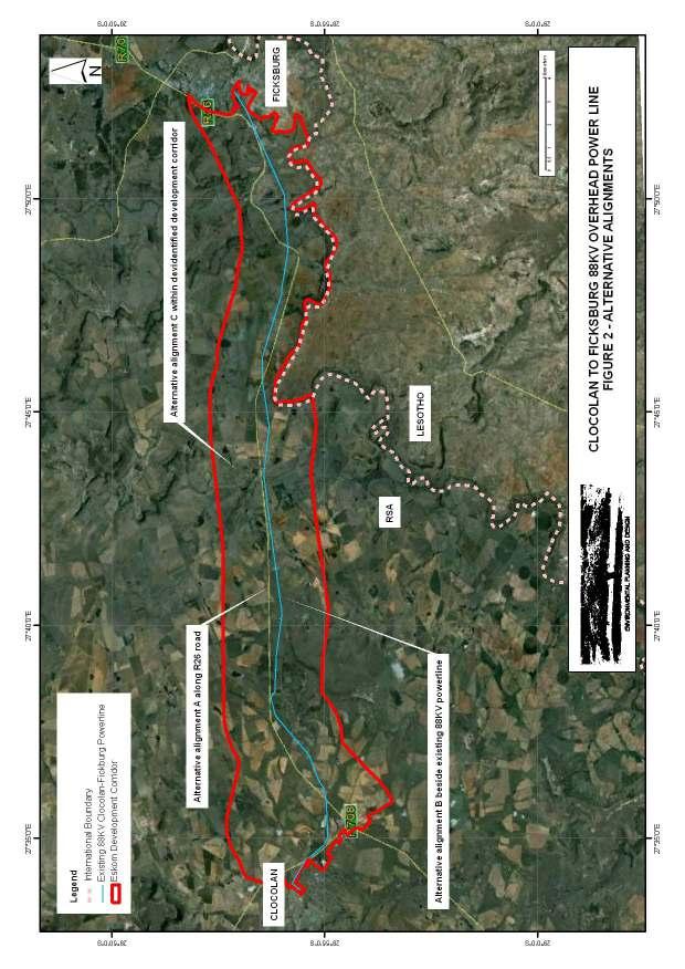
10 2.3.5 Inclusion of potential lighting impacts at night The potential for light pollution is usually documented based on a comparison of the density and intensity of existing lighting and likely level of lighting associated with a proposed development. In the case of the proposed power line however, there will be no lighting associated with the development. There will therefore be no potential for light pollution Description of alternatives and possible mitigation measures. The location of the possible corridor has been established by the Applicant. The detailed criteria for this are not known but it is assumed that the selection of the corridor is based on a number of criteria including; Land ownership. Development costs. Topography. Access requirements for maintenance. From discussion with the Principle Consultant, the identified alternatives include; A. Development along the R26 road. B. Development along the existing 88KV power line route. C. Development along a new alignment within the identified corridor. Possible mitigation measures include the use of alternative poles / pylons which include a solid pole structure with various cable configurations or a steel lattice pylon structure similar in nature to the existing 88KV line. The alternative designs are attached as Appendix II for information. Photographs of the existing steel lattice pylon structures and a solid pole structure found in the region are indicated in Photographic Plates 1 and Review by independent, experienced visual specialist (if required). A review has not been undertaken in the preparation of the Draft Report. 10
11 11


12 PLATE 1 - EXISTING 88KV OVERHEAD POWER LINE, STEEL LATTICE PYLON STRUCTURE PLATE 2 - EXISTING 88KV OVERHEAD POWER LINE, SOLID STEEL MONOPOLE TOWER 12
13 3 PROJECT DESCRIPTION AND NATURE OF VISUAL IMPACTS 3.1 GENERAL Details regarding the precise locations the alternative lines and of poles / pylons were not available at the time of reporting. Descriptions of alternative alignments as indicated in were provided verbally by the Principle Consultant. Alternative alignments A and B as well as the possible development corridor are indicated on Figure 2, Alternative Alignments. 3.2 PROJECT DESCRIPTION Ficksburg Local Municipality is supplied from the Clocolan Distribution Sub-station via an existing 88 kv power line. The maximum demand for the transformers was measured at16.82 MVA in 2011, which is 84% loading of the installed capacity. The sub-station is a radial sub-station with approximately 9,000 customers. A fault on the existing 88 kv power line results in supply lost to all customers. This project will result in the construction of a radial feed which will ensure a secure supply should one of the power lines experience a fault. The construction process is likely to follow the following sequence; Excavation and concrete work for tower bases. Due to the dispersed nature of the bases, it is unlikely for concrete to be batched on site. It is likely that concrete will be ready mixed and brought in by concrete trucks as and when required. Erection of towers in a progressive manner. It is common for materials for a number of poles to be delivered to site at the same time. Erection requires the use of a mobile crane to hold prefabricated elements in position. This process is relatively rapid as each pole / pylon is prefabricated off site. Stringing of cables which also requires the use of cranes and mobile hoists to enable workers to fix insulators and attachments and to pull cables between towers. The above process is relatively clean, rapid and only affects the area immediately surrounding each tower location. 13
14 An operating servitude will have to be registered in favour of Eskom to protect the alignment. The servitude will prevent development and any other use that could compromise the overhead line. It will not prevent current agricultural uses or access beneath the line. The following dimensions have been provided by the Applicant. Tower height: 18-24m Tower spacing: m Tower type: monopole Operating servitude: 31m (15.5m x 2) 3.3 NATURE OF VISUAL IMPACTS Initial construction is unlikely to have a significant visual impact. Initially work will take place around each tower. Activities will be obvious over limited areas only. The most obvious elements are likely to include; Storage of poles / pylons for tower construction. Trucks and mobile cranes As work progresses, towers will become obvious in the landscape. Work is likely to take place on a limited number of towers at any one time which means that during construction, towers will gradually appear in the landscape on a progressive basis. By the end of the construction process, when cables have been strung between towers, the full visual impact of the project will be experienced. The operational phase is highly unlikely to result in any significant additional impact. It is possible however, that crews will be visible from time to time undertaking maintenance on individual towers. Overhead power lines are a familiar sight within the region. Typically, from a distance, the towers that are more obvious than the overhead conductors. This is because the towers are reasonably substantial structures whereas the overhead conductors have a relatively small diameter. Whilst the overhead conductors are generally not highly visible from a distance, under certain conditions, they can be made more obvious by reflected sunlight. 14
15 From short views the overhead conductors are generally relatively obvious. Plate 2 indicates a photographs of the existing overhead 88KV power line that is similar to the proposed. In the middle of the image is a tower with overhead conductors that is within 100m of the viewer. Both the lines and tower structure are highly obvious. Another thing to note from Plate 2 is that because the structure of the lattice pylons is open, they become significantly less obvious with distance. By the third setoff towers (at a distance of approximately m from the viewer, whist the towers are visible they are certainly not sufficiently obvious to draw the eye away from the overall view. The effect of the lattice pylons visually blending into the backdrop will differ with weather and lighting conditions, however the photographs were taken on an exceptionally clear day and they are likely to illustrate a close to worse-case scenario. The relative impacts associated with use of a solid pole structure or a lattice pylon is also an issue that needs consideration. Plate 2 also serves to illustrate the relative impacts. The view is of a low voltage overhead cable on the right of the road suspended on solid poles and the existing 88KV overhead line on the left side of the road suspended on a series of lattice pylons. It should be noted that the solid poles are substantially smaller than those required for this project. The key observation to be made from this comparison is that; From a short distance (first pylon and solid pole) the overall size of the pylon is more obvious and whilst the structure is partially transparent, the visual mass is greater than the solid pole on the opposite side of the road which is a more slender structure. With distance the lattice pylons increasingly blend into the background and become more transparent whereas the solid poles on the opposite side of the road remain obvious. With the larger solid towers that will be required for the proposed project, this effect is likely to be more marked. In summary the following conclusions can be drawn from these observations; Overhead conductors are unlikely to be obvious at a distance of more than m. 15
 the visual mass of a lattice pylon is likely to be greater and therefore more obvious than a solid pole structure.")
16 Lattice pylon structures are likely to visually blend into the background at a distance of approximately 900m. At a short distance (less than 100m) the visual mass of a lattice pylon is likely to be greater and therefore more obvious than a solid pole structure. At a distance of 250m-300m, lattice pylon is likely to have greater transparency and therefore be less obvious than a solid pole structure. As indicated previously these general effects will vary with lighting and weather conditions. PLATE 3, VIEW OF SIMILAR LINE TO THAT PROPOSED, NOTE 3 RD AND 4 TH PYLONS ARE JUST VISIBLE 16
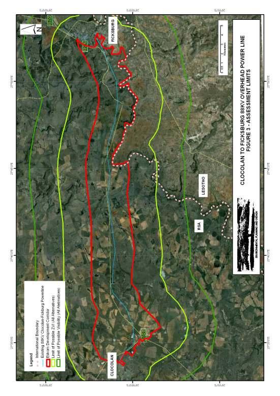
17 4 ASSESMENT LIMITS 4.1 VISUAL ENVELOPE The Guidelines define the Visual Envelope as the extent of potential visibility. The only consideration necessary in defining this is to establish where the development may be visible from. The extent of the area from which a site may be visible is dependent upon landscape features that might screen the site as well as the height of the development above the natural visual horizon (Where the sky appears to meet the Earth). Assuming that the highest element of the proposed mine is in the order of 20m high the proposed power line could be visible in a flat landscape for approximately 18km. However, due to the surrounding ridgelines and the general rolling topography of the agricultural landscape in which the greater part of the proposed overhead power line is proposed, this distance is significantly foreshortened. The Visibility Analysis undertaken in Section 6 indicates that the proposed development is possibly visible over a wide area up to 20km and beyond. However at this distance, the proposed power line is unlikely to be distinguishable from its general surroundings. The assessment also indicates that past 6km distance views of the existing power line become very broken. It is proposed therefore that a distance of 6km from the proposed alignment is set as the assessment limit. 4.2 ZONE OF VISUAL INFLUENCE (ZVI) In accordance with the Guidelines the ZVI is the area within which the proposed development could have an effect on visual amenity. In addition to line of sight, the main issue in defining the ZVI is the likely effect of distance on the type of impact that will be experienced. Plate 3 indicates an overhead power line similar to that proposed. The view is taken along the line of towers which have a spacing of +/- 250m. In total 9 towers are 17

18 visible along the line before it connects to a line running at right angles. The last tower in the line which is a solid pole structure is just visible at +/-2.5km. The towers of the line running at right angles is lattice pylons, these are barely visible. From this brief assessment, it is suggested that the maximum ZVI of the proposed development is likely to be in the order of km. 4.3 ASSESSMENT LIMITS Figure 3, Assessment Limits, indicates the limit of both the Visual Envelope and Zone of Visual Influence for the project. The limits assume that the alignment is located within the identified Eskom Corridor. They have been calculated using a 3km buffer from the edge of the corridor for the limit of possible ZVIs and a 6km buffer from the edge of the corridor for the limit of possible Visual Envelopes. PLATE 4, VIEW OF SIMILAR LINE TO THAT PROPOSED, NOTE PYLONS ON THE HORRIZON ARE JUST VISIBLE 18
19 19
20 5 DESCRIPTION OF RECEIVING ENVIRONMENT AND RECEPTORS 5.1 GENERAL The landscape character of the area is largely a product of landform / drainage patterns, vegetation cover and built structures Landform / Drainage Patterns The study area is located to the north of the Maliti Mountains in the southern Free State. The mountains form a high backdrop to views when travelling in a west to east direction through the study area. The town of Ficksburg at the eastern end of the proposed alignment is located at an elevation between 1550 and 1600 m amsl. The town of Clocolan at the western end of the proposed alignment is located at an elevation in the order of 1600 m amsl. There is therefore no appreciable drop in elevation across the length of the study area although there are significant localised variations. Within and adjacent to the study area are a number of small peaks and ridges that are formed from sandstone outliers from the main mountain range. One such ridge wraps around the northern and western edges of Ficksburg. This landform here rises to approximately 1850m amsl. An impressive gorge has been eroded through this ridge by the Meul River. The existing R26 road passes through this gorge. The Meul River has been dammed immediately to the north of the road. Whilst this dam is on private property it is understood that it is a popular camping area and the area surrounding it is used for the annual Ficksburg Cherry Festival. To the west of the gorge within the study area the landform generally flattens to into a series of rolling small rounded ridgelines and valleys that generally run in a north to 20
21 south direction. Small water courses flow through the valley lines. The ridgelines are in the order of 30-40m higher than the valleys. To the north of the entire study area there is a an impressive series of peaks / ridgeline that runs in a broadly east to west direction for the entire distance between Clocolan and Ficksburg. This landform is an extension of the ridgeline that forms the gorge to the west of Ficksburg. For the majority of the study area the this landform is 10 or more from the northern edge of the corridor. However at approximately half way between Clocolan and Ficksburg, a secondary ridgeline running in a north to south direction from the main landform extends to within 5km. At approximately between 3km and 5km from Clocolan there is a minor peak / ridgeline that rises within the southern portion of the identified corridor and to the south of the existing road to approximately 1750m amsl. This landform extends generally in an east to west direction, however levels generally rise across the study area creating a minor ridgeline from which panoramic views towards are possible in both an easterly (towards Ficksburg) and westerly (towards Clocolan) are possible. The landform as described has the following influence on views from the study area; i. Long range panoramic views of the surrounding landscape are possible from the higher areas within the study area. ii. The Maluti Mountains provide a dramatic backdrop to panoramic views to the west and south. iii. To the north, the ridgeline that extends outside the study area provides a backdrop to views. iv. To the west, there is no obvious backdrop to views although there are numerous isolated hills and ridgelines that are visible. v. The minor valley lines that cross the study area have the effect of screening panoramic views of the surrounding landscape. vi. The Meul Gorge immediately to the west of Ficksburg provides a visually dramatic entrance to the town. This landform screens all distant views. 21

22 PLATE 5, LONG RANGE PANORAMIC VIEWS POSSIBLE FROM HIGHER AREAS. PLATE 6, THE MALUTI MOUNTAINS FORM A BACK DROP TO VIEWS TO THE SOUTH AND EAST. 22


23 PLATE 7, TO THE NORTH A RIDGELINE EXTENDS JUST OUTSIDE THE PROPOSED DEVELOPMENT CORRIDOR. PLATE 8, TO THE WEST THERE ARE NO CONTINUOUS BACKDROPS TO VIEWS BUT THERE ARE ISOLATED RIDGELINES AND HILLS. 23


24 PLATE 9, MINOR VALLEY LINES HAVE THE EFFECT OF SCREENING WIDER PANORAMIC VIEWS. PLATE 10, MEUL GORGE PROVIDES A DRAMATIC ENTRANCE TO THE TOWN OF FICKSBURG Vegetation Cover The general vegetation cover reflects the agricultural practices and settlement patterns within the study area. 24
25 Within the urban areas of Ficksburg and Clocloan, street trees and garden vegetation prevail. In many areas this vegetation prevents extensive views both within the towns and from the urban areas into the surrounding rural landscape. The majority of the rural area between Clocolan and Ficksburg is under agriculture of one form or another. The type of agriculture is mixed and includes, fruit growing, arable crops and cattle grazing areas. The effect of these agricultural practices is to maintain the landscape largely free of trees and groups of vegetation that might foreshorten views. There are three exceptions to this in the following areas; i. At approximately 6.3km to 8.2km from Clocolan there are significant plantations of largely alien tree species. This coincides with a section of the existing 88kv overhead power line converging closely with the R26 road. Due to the plantations, even though the overhead line is close to the road it is barely visible to people travelling on the road. ii. At approximately kmfrom Ficksburg as the existing road drops into the valley line before entering the Meul Gorge, there are extensive thickets / plantations of largely alien trees. These plantations have the effect of largely screening views of existing pylons in an area where the existing overhead line crosses the road on the approach to Ficksburg. iii. Within the minor valley lines there are scattered trees and taller vegetation which have the effect of softening views of existing pylons at points where the existing overhead line crosses the road. 25


26 PLATE 11, THE URBAN AREAS ARE WELL TREED LIMITING VIEWS TO THE SURROUNDING RURAL AREA. PLATE 12, PLANTATIONS OF ALIEN TREES LARGELY SCREEN THE POWER LINE FROM THE ROAD (6.3KM TO 8.2KM FROM CLOCOLAN). 26

27 PLATE 13, MINOR VALLEY LINES WITH SCATTERED TREES AND TALLER VEGETATION Development Existing development generally includes; i. The urban areas of Ficksburg and Clocolan at the eastern and western ends ii. iii. of the proposed alignments respectively. The formal centres of the towns are well treed to the extent that generally only views within the town centres are possible. On the edge of each urban area in the vicinity of the substations that the proposed overhead line will commence and terminate at, there are large housing areas. These housing areas are well established to the extent that garden vegetation including trees has established between the houses. This vegetation also has the effect of reducing views of adjacent rural areas from within the housing areas. Only residents on the edges of these housing areas have a view over adjacent rural areas Within the rural area between the two towns there are a number of small agricultural settlements based on local farms. Other development that is obvious within the landscape includes; 27


28 iv. A group of tall agricultural silos adjacent to the road on the eastern edge of Clocolan. These are the largest obvious landmark on the approach to Clocolan along the R26. v. A farm stall adjacent to the road approximately 10k from Clocolan. This is comprised of an isolated building that has an agricultural character. It doesn t significantly detract from the general rural agricultural character of the area. PLATE 14, LARGE HOUSING AREA IN THE VICINITYOF THE FICKSBURG SUBSTATION PLATE 15, SMALL AGRICUALTURAL SETTLEMENT ASSOCIATED WITH FARMS 28


29 PLATE 16, LARGE SILOS ARE AN OBVIOUS LAND MARK AT CLOCOLAN PLATE 17, FARM STALL APPROXIMATELY 10KM FROM CLOCOLAN Existing Infrastructure Existing infrastructure within the prosed development corridor includes; 29
30 i. The R26 Road ii. Local un-surfaced roads iii. The existing 88KV overhead power line. iv. Overhead low voltage power lines. v. Railway. vi. Telecommunications masts. With the exception of telecommunications masts, these elements are aligned from east to west through the corridor. They therefore have a reasonably consistent influence on landscape character throughout the study area. Telecommunications masts can be seen on hill sides and ridges particularly to the south of the identified corridor. They are however located more than 4km from the centre of the corridor (R26) and therefore do not have a large influence on landscape character. i. The R26 Road The road follows an alignment that is approximately central to the possible development corridor identified by Eskom. This is the main route between Clocolan and Ficksburg. It also carries all regional traffic from the Western and Northern Free State. This route is therefore an important regional link road. The R26 between Clocolan and Ficksburg is also part of the Maluti Route which is being developed by regional and local tourism bodies as a tourism development corridor. ii. Local Un-surfaced Roads There are numerous un-surfaced local roads that link into the R26. These generally serve local communities, however one also links to the Peka Bridge border control (RSA / Lesotho) so it also carries cross border traffic. iii. Existing 88KV overhead power line 30
31 This is generally aligned away from the R26 road. The distance from the road varies up to1.2km but is generally located within 500m of the road. The overhead line also crosses the road in three areas. As indicated in section 3.2, this power line is critical to the supply of electricity to Ficksburg. This power line is generally suspended on steel lattice pylons that are of similar scale to the proposed project. In areas pole structures have also been used. iv. Overhead low voltage power lines In areas overhead low voltage lines are obvious both adjacent to the road and within the surrounding landscape. These are lower than the 88KV lines (approximately 10m high as opposed to +/- 20m) and are supported on solid gum tree poles. v. Railway A single railway track runs through the landscape to the north and close to the R26. From observations during the site visit (over two days), the line does not appear to be busy as no trains were seen. The line is either screened from the road by vegetation or landform or is set slightly higher than the road resulting in it not being highly obvious in the landscape. vi. Telecommunications masts. A small number of telecommunications masts can be seen on hillsides and ridgelines particularly to the south of the study area. These are located at some distance from the corridor, they also appear to be lattice type steel structures. Whilst they are visible the distance and nature of the structures result in them not being highly conspicuous to viewers within the corridor. 31
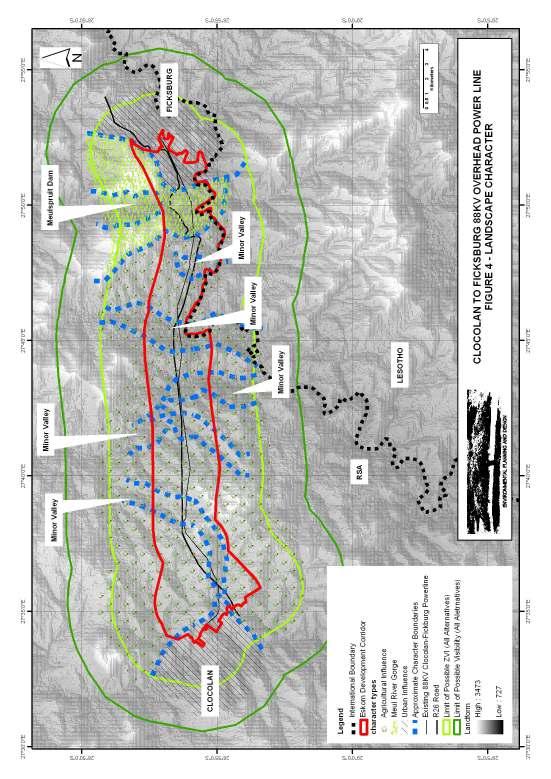
32 5.2 LANDSCAPE CHARACTER AND SIGNIFICANCE Landform, vegetation and the extent / nature of development are the main character defining elements. In broad terms the landscape can be divided into the following character zones (Refer to Figure 4); a) Settlement areas at both ends of the proposed alignment where housing development dominates the land use. In both these areas views of rural areas are possible along roads and from the edges of development. Also within both of these areas, overhead power lines are highly obvious. b) The area of rugged topography (Meul River Gorge) to the west of Ficksburg. Views are dominated by the steep hill slopes that frame the gorge. Vegetation is far from natural or pristine; the valley floor is largely planted with alien tree species, the upper slopes are generally natural grassland however, even here there is a large proportion of alien invasive woody plants. c) The area around the Meulspuit Dam immediately to the north of the gorge. The area of open water between two large ridgelines in this area makes it very different from other areas within the study area. d) The rolling topography of the main agricultural area between Ficksburg and Clocolan. This area is relatively flat and generally open so long distance views are possible. When looking south and east from within this area the Maluti Mountains provide an impressive backdrop. Views to the north are generally contained by the ridgeline and more minor peaks that also provide interest. Within this general area there are two sub areas where local conditions restrict the long range views that are generally possible; i. Within the valley lines that bisect the zone, views out of the valley are generally curtailed by the 30 40m high valley sides. ii. Within two areas plantations of alien trees have been planted or allowed to develop. In these areas views are blocked by the plantations. In terms of significance, the landscape is likely to hold differing relevance for the various groups of people who use and live, work and visit the area. 32
33 For a large proportion of land owners and agricultural workers, the landscape is important primarily for its production capability. Aesthetics are likely to be a secondary consideration. For residents of the housing areas adjacent to Clocolan and Ficksburg, aesthetics are also likely to be a secondary consideration. These are generally poorer sectors of the community. In these areas the emphasis is likely to be on finding and maintaining employment. Tourists who travel through the area along the R26 are likely to value the scenic quality of the landscape highly. The natural rugged landform of the Maluti Mountains is the main tourism attraction. To be able to have long range views of this across the open agricultural potentially provides potential within the study area for tourism related attractions as are foreseen by recognition of the R26 as part of the Maluti Route. The Meul Gorge at the approach to Ficksburg also reinforces this tourism potential. Local people who use the area around the Muelspruit Dam to the west of Ficksburg for recreational activities and for the annual Ficksburg Cherry Festival are attracted to this area for a reason. The steep hill slopes surrounding the water body provide a dramatic but sheltered landscape for local recreational activities. It is likely that this area is highly valued amongst local people. Many residents and business people in the town of Ficksburg appear to rely on visitors who are attracted to the area for its natural scenery for an income. This is obvious from the many bed and breakfast establishments in the Town. These people are likely to value the natural scenery within the study area. The landscape within the study area therefore has large significance in terms of its current value for tourism. A part of this value still has to be realised, this will possibly occur with further development of the Maluti Route. Whilst for a large portion of the community, the aesthetics of the area are likely to be a secondary consideration, the reduction of potential to generate incomes for local 33

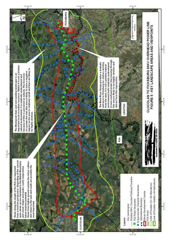
34 people that could result from degrading of the landscape will be obvious. This could mean that a large proportion of local people understand and value the landscape even though it may not be a primary concern. 5.3 IMPORTANT VIEWPOINTS Important viewpoints within the study area include; a) Views from the entire length of the R26. It is from this road that tourists experience the area. It is likely that views to the south and east are more important than views to the north and west due to the backdrop of the Maluti Mountains that can be seen in this direction. b) Views within the Meul Gorge. This feature provides an impressive entrance to Ficksburg and whilst it is far from a pristine landscape, the overall impression is of entering a mountain pass. c) Views from around the Meulspruit Dam. This area is an important local recreational resource. These areas are indicated on Figure 5. PLATE 18, THE MEULSPRUIT DAM IS AN IMPORTANT LOCAL RECREATION RESOURCE 34
35 35
36 36
37 6 LANDSCAPE AND VISUAL EFFECTS 6.1 GENERAL Three areas of concern have been identified; Views from the R26 particularly to the south and east. Views from around the Meulspruit Dam Views from within the Meul Gorge. 6.2 VIEWS FROM THE R26 The following considerations are relevant; Views of the existing 88KV overhead line The distance of a possible alignment from the R26 The nature of proposed towers Views of the existing 88KV line The existing 88KV overhead line already has an impact on the area. It is generally located away from the R26 however it does come close to the road in two locations and crosses the road in three locations. The existing road crossings occur within minor valley systems. From within these valleys broad panoramic views of the surrounding landscape are generally not possible. This means that the highest impact areas are relatively localised and do not affect the key long distance views to the south and east. To the east of the alignment, the line crosses the R26 to the southern side within a small valley line close to Clocolan. It then deviates away from the road to a distance of approximately 700m before turning back towards the road. At approximately 5km from Clocolan the line is less than 100m from the road. For the majority of this section, the towers being lattice steel pylons are sufficiently transparent and at a sufficient distance to result in small existing impact. It possibly would be better if the towers were not visible however they do not significantly detract from the views of the surrounding landscape. 37
38 As the existing line runs close to the road between approximately 5km and 6km from Clocolan, it is screened within large plantations of trees. In this area, an observer has to know where the line is and actually look for it in order to glimpse views of it between the trees. Between 6km and 15km from Clocolan, the existing line remains on the southern side of the R26. It deviates away from the road alignment to a distance of approximately 650m. As is the case over the initial 5km, the lattice towers are sufficiently transparent to help minimise impacts. The landform also falls away over this section which also helps to reduce impacts. Over the next 3km (15km to 18km from Clocolan), the existing power line runs parallel to the R26 at a distance of approximately 100m from the road. Over this distance the existing line is obvious, however, the road passes through two small valley lines and so for much of the distance panoramic views of the surrounding landscape are not possible. From approximately 18km to 22km from Clocolan the existing overhead line again deviates from the road alignment to a distance of approximately 600m from the road. Over this distance, the landform which generally falls away from the road and the transparency of the lattice pylons help to minimise impacts. At approximately 22km from Clocolan, the overhead power line converges and crosses the road. The convergence and the crossing all occur within a minor valley, so again, impacts are limited to short range views of the valley and panoramic views of the broader landscape including of the Maluti Mountains are unaffected. For the next 6km (approximately 22km to 28km from Clocolan) the existing overhead power line runs parallel and approximately 500m from the road. At this distance and again because the towers are relatively transparent lattice pylons, these structures tend to blend into the background ridgelines. 38
39 At approximately 28km from Clocolan, the existing power line crosses the R26 for the last time to the southern side of the road. This crossing again occurs in a minor valley and so the impact on broader landscape views are limited. The crossing also occurs immediately after the ridgeline and is at least part screened by landform and trees. The crossing itself is therefore not conspicuous even within the valley landscape. From approximately 28km to 32.5km from Clocolan, the existing overhead power line alignment again deviates from the R26. From this point the line deviates to approximately 1.4km away from the road and it is aligned around the outside of the Meul River Gorge. As the road is aligned through the gorge, views of the line from the road are not possible and the natural effect is not spoilt for road users. From approximately 32.5km from Clocolan to the end of the proposed alignment the existing overhead power line converges again with the road and runs parallel an close to the last section that leads to the existing sub-station. This section of road is very much a local access road and is unlikely to carry tourism traffic.. In conclusion it would have been possible to reduce the visibility of the existing overhead power line from the R26 by aligning it further away from the road. However, in most areas that matter; where long panoramic views of adjacent mountains are possible and within the Meul Gorge, the existing line is not highly obvious. It therefore only has a small impact on the quality of views from the road. If the proposed new line were to follow the existing overhead power line it is likely that visibility of the lines might increase marginally, however, in most areas, the distance between the road and the line would be sufficient to ensure visual impact would not increase significantly. 39


40 PLATE 19, ROAD CROSSING IN A MINOR VALLEY SYSTEM. THE CROSSING IS SCREEMED LARGELY BY VEGETATION PLATE 20, EXISTING LINE RUNS CLOSE TO ROAD IN A MINOR VALLEY. THE MORE IMPORTANT PANORAMIC VIEWS ARE SCREENED BY THE VALLEY SIDES AND SO ARE NOT SPOILT. 40


41 PLATE 21, EXISTING ALIGNMENT RUNS CLOSE TO ROAD THROUGH PLANTATION AREA. TREES LARGELY SCREEN THE IMPACT PLATE 22, PYLONS ARE GENERALLY VISIBLE BUT DO NOT DETRACT SIGNIFICANTLY FROM VIEWS OF THE RURAL LANDSCAPE The distance of a possible alignment from the R26 One of the possible alignment alternatives under consideration is aligning the proposed overhead power line adjacent to the R26. If this were to occur then the impact is likely to be similar to that indicated in Plate 1 which shows a view of the existing overhead line adjacent to the local road leading to the existing substation in 41
42 Ficksburg. It might be argued that the view of the natural landscape beyond would still be visible, however, the introduction of the tower structures and overhead line into the foreground of the view is likely to have a significantly negative effect on the perceptions of people travelling along the road. Obviously the further that the new line can be located from the road, the less that it will be obvious. The assessment included in Section 4 indicates that at 2.5km to 3.0km distance from the viewer the power line is likely to be barely visible. This would therefore be the optimum distance in terms of minimising the impact on views from the road. If the proposed overhead line had to be aligned adjacent to the road then the north side of the road should be selected as this would not affect views to the south and east towards the Maluti Mountains. It is however likely to affect the overall impression of the area for visitors and tourists The nature of proposed towers. As indicated in Section 4, because of their smaller visual mass, monopole towers are likely to be less conspicuous than lattice pylons when viewed from a short distance. This is because over a short distance the overall width of the pylon structure is obvious. When viewed from a long distance however, the lattice pylon is likely to be the least obvious as the individual elements of the structure become less obvious and tend to blend into the backdrop. 6.3 VIEWS FROM AROUND THE MEULSPRUIT DAM This area is enclosed by ridgelines on either side of the dam. Placing the proposed overhead power line within this landscape is likely to impact negatively on views of the perceived natural environment. 42
43 6.4 VIEWS OF THE MEUL RIVER GORGE As in 6.3 placing the proposed overhead power line within this landscape is likely to impact negatively on views of the perceived natural environment. 43
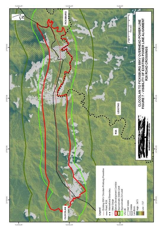
44 7 VISIBILITY 7.1 VISIBILITY FOR RECEPTORS A receptor is defined by the Guidelines as a physical landscape resource, special interest or viewer group that will experience an effect. A visibility assessment has been undertaken using ArcGIS Spatial Analyst. This indicates how visible the mine and associated infrastructure is likely to be to surrounding areas. The visibility assessment has been undertaken using NASA s 90m digital elevation database that was obtained from the Consultative Group for International Agricultural Research / Consortium for Spatial Information. The elevation values were obtained from NASA aerial photography and have been checked against GPS values obtained in the field. This is the most accurate information covering the possible areas of visibility that was available. The computer generated visibility assessment is based on topography, it therefore needs to be considered in the context of limiting factors identified from the site visit that are detailed in Sections 4 and 5. In order to assist with this the following distance buffers are indicated on the assessment maps; The 3000m buffer indicates the area within which landscape changes associated with the proposed power line could have an impact on visual amenity (Zone of Visual Influence). The 6000m buffer indicates the general limit of visibility within which elements could be visible (Visual Envelope). 7.2 VISUAL ENVELOPES In order to provide information for a comparative assessment visual envelopes have been prepared for; The proposed overhead power line aligned along the existing power line alignment. As indicated previously, the area of highest impact associated with this alignment is likely to be in areas where the power line crosses the R26. 44
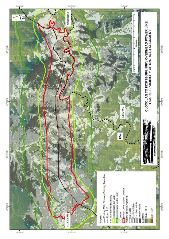
45 From observations on site it appeared that crossings generally occur in minor valleys which have the effect of limiting the extent of impact. In order to test this observation, a visual envelope has also been prepared for the road crossings. The proposed overhead power line aligned along the R26. The proposed overhead power line aligned along the northern and southern limits of the possible development corridor that was identified by Eskom. These alignments have been used as the assessment so far indicates that from a visual perspective, the further that the proposed overhead power line is from the existing R26 the less the line is likely to be visible to this tourism route. By adopting the two possible extremes this will provide an indication as to whether a more detailed alignment investigation might be beneficial. Figures 6 to 10 inclusive indicate the visual envelopes described above. It should be noted that the Visual Envelopes have been prepared by placing points at 1km centres along the proposed alignments. The resulting assessment therefore provides an indication of the extent of the proposed alignment that is likely to be visible from each area Existing Alignment Figure 6 indicates the likely visibility of the proposed overhead power line along the alignment of the existing power line. Figure 7 indicates the likely visibility of the proposed overhead power line as it crosses the R26. These maps indicate that; a) Visibility of the alignment around the Meul River Gorge and Meulspruit Dam is relatively low. This is to be expected as the existing alignment passes to the south of the gorge. Parts of the alignment that might be visible to these areas are likely to be seen at a distance. This impact is therefore likely to be minimal. 45
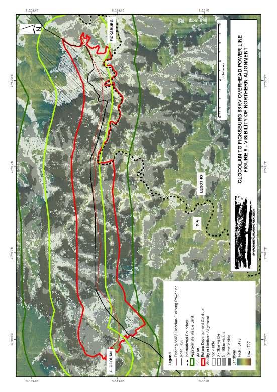
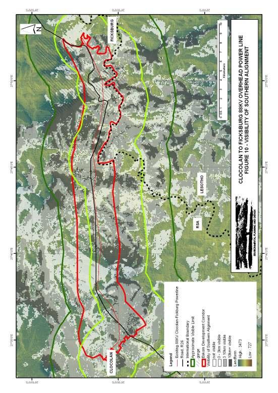
46 b) The areas from which a large extent (+10km) of the alignment could be visible coincide with high points in the landscape. They also coincide with areas where the existing alignment is some distance ( m) away from the road. This means that views of the overhead power line from the R26 are likely to be significantly mitigated by distance. c) The road crossings only impact on limited areas in and around the minor valleys Road Alignment Figure 8 indicates the likely visibility of the proposed overhead power line along the alignment of the existing road (R26) This map indicates that the alignment along the R26 is likely to be visible to similar areas as the existing alignment. This is possibly to be expected as the over much of its length, the existing alignment deviates from the road by relatively short distances. However, these small deviations are significant in terms of mitigating the significance of the impact Northern and Southern Alignments Figure 9 indicates the likely visibility of the proposed overhead power line along the northern edge of the possible development corridor as identified by Eskom. Figure 10 indicates the likely visibility of the proposed overhead power line along the southern edge of the possible development corridor as identified by Eskom. These maps indicate that the southern alignment is likely to be visible over a significantly smaller area than the northern alignment. This indicates that if an alternative alignment is to be considered it should be located to the south of the identified corridor. 46
47 47
48 48
49 49
50 50
51 51
52 8 POTENTIAL VISUAL IMPACTS AND POSSIBLE MITIGATION MEASURES Criteria for the assessment provided by ACER Environmental Management Consultants are attached as Appendix III. 8.1 EXISTING OVERHEAD POWER LINE ALIGNMENT CRITERIA RATING Note Nature Negative / Neutral The existing line has already created a visual impact. If the line follows close to the existing then the current impact may be slightly reinforced particularly at road crossings and in areas where the line runs close to the road, however, the increased impact is not likely to be significant. Spatial Extent Medium Impacts are likely to extend beyond 2km. Duration High The power line is likely to be in place for the foreseeable future. Intensity Low The new line is unlikely to be highly obvious. Irreplaceability of resource caused by impact Low to Medium The new line is unlikely to impact new areas. Reversibility of impact Moderate The project would be relatively easily reversible. Consequence Low The low consequence is due to the current impact. Probability of the impact occurring Low to Medium The low to medium rating is due to the fact that a large proportion of people travelling along the R26 are unlikely to notice that a new power line had been added along the existing power line alignment. Significance Low to Medium Possible mitigation measures might include; 52
53 a) Ensuring that the design reflect the existing power line as far as possible. This might include aligning existing and new towers. b) Ensuring that all road crossings remain within valleys. c) The use of solid monopoles might be considered where the alignment runs close to key areas. However, this needs to be considered against the difference in the existing and proposed towers making the addition of the new line more obvious. 8.2 R26 ROAD ALIGNMENT CRITERIA RATING Note Nature Negative The development will be highly obvious and will detract from views of natural areas. Spatial Extent Medium Impacts are likely to extend beyond 2km. Duration High The power line is likely to be in place for the foreseeable future. Intensity Medium to Highly obvious High Irreplaceability of resource caused by impact High Impacts on all important recreational / tourism related areas including; Meulspruit Dam, Meul River Gorge Views from the R26 Reversibility of impact Low The project would be relatively easily reversible. Consequence High The high consequence is due to a new impact on key resources. Probability of the impact occurring High It is likely that all people who travel along the R26 will notice the new overhead power line. Significance High Possible mitigation might include; a) The use of solid monopole towers, however, this is unlikely to significantly reduce impacts. 53
54 8.3 NORTHERN ALIGNMENT CRITERIA RATING Note Nature Negative / Neutral The development will not be obvious from views of the natural landscapeas seen from the R26 or the Meul River Gorge / Meukspruit Dam Spatial Extent Medium Impacts are likely to extend beyond 2km. Duration High The power line is likely to be in place for the foreseeable future. Intensity Low The development will not be obvious from key tourism / recreational resource areas. Irreplaceability of resource caused by impact Medium The development will not be obvious from key tourism / recreational resource areas. It will however create new areas of impact. Reversibility of impact Medium The project would be relatively easily reversible. Consequence Medium The medium consequence is due to the creation of new areas of impact. Probability of the impact occurring High The new impact areas are likely to be obvious to those in the vicinity. Significance Medium 8.4 SOUTHERN ALIGNMENT CRITERIA RATING Note Nature Negative / Neutral The development will not be obvious from views of the natural landscapes seen from the R26 or the Meul River Gorge / Meukspruit Dam Spatial Extent Medium Impacts are likely to extend beyond 2km. Duration High The power line is likely to be in place for the foreseeable future. Intensity Low The development will not be obvious from key tourism / recreational resource areas. Irreplaceability of resource Medium The development will not be obvious 54
55 caused by impact from key tourism / recreational resource areas. It will however create new areas of impact. Reversibility of impact Medium The project would be relatively easily reversible. Consequence Medium The medium consequence is due to the creation of new areas of impact. Probability of the impact occurring High The new impact areas are likely to be obvious to those in the vicinity. Significance Medium 55
56 9 CONCLUSION The assessment indicates that locating the proposed 88KV overhead power line parallel and close to the R26 is likely to compromise views from the road which could impact negatively on tourism as well as the enjoyment of recreational areas by local people. This alternative is therefore not supported. Locating the proposed overhead power line as far as possible from the R26 which is an important tourism route and key landscape areas of the Meulspruit Dam and Meul River Gorge is the obvious method of minimising visual impact on these resource areas. However there is an existing 88KV overhead power line running through the identified corridor with existing visual impacts. The assessment has indicated that whilst the overhead line is visible, these impacts do not significantly spoil the enjoyment of long range views towards the Maluti Mountains and adjacent foot hills. Where impacts are greatest they are generally contained by minor valley systems that cross the development corridor. Due to the distance that the existing power line is away from key viewpoints and landscapes and due to other mitigatory effects including tree plantations and landform, it is likely that the new power line might run parallel and close to the existing line without significantly increasing existing impacts. This would also help to prevent an increase in the footprint within the rural landscape. If a new alignment is required, the assessment indicates that it is likely that locating it to the south of the development corridor is likely to be less visible than locating it to the north. This however is a general conclusion that would have to be tested following alignment planning input from relevant technical experts. The favoured alternative from a visual impact perspective is therefore to develop the new line in close proximity and parallel to the existing line and to use the migration measures indicated in
57 REFERENCES Guidelines for involving visual and aesthetic specialists in EIA processes, Author; Bernard Oberhozer. Published by the Provincial Government of the Western Cape: Department of Environmental Affairs and Development Planning, 2005 Guidelines for landscape and visual impact assessment (second edition), authors; the Landscape Institute and Institute of Environmental Assessment and Management, published by E & FN Spon, 2002 Methods of Environmental Impact Assessment, edited by; Peter Morris and Riki Therivel, Oxford Brookes University, UCL Press, Manual of Environmental Appraisal, UK Department of Transport, 1992 Australian Capital Territory (Planning and Land Management Act 1988, Amendment No 18 (ACT Telecommunications Plan) Visual Impact Assessment Guidebook, Second Edition. Province of British Colombia. January 2001 GeoNetwork website. 57
58 APPENDIX I SPECIALIST S BRIEF CV 58
59 Name JONATHAN MARSHALL Jonathan Marshall Curriculum Vitae of Key Personnel Nationality British Year of Birth 1956 Specialisation Landscape Architecture / Environmental Planning Qualifications Education Professional Diploma in Landscape Architecture, Gloucestershire College of Art and Design, UK (1979) Member of the Landscape Institute (UK) Member of the International Association of Impact Assessment, South Africa Languages English - Speaking - Excellent - Reading - Excellent - Writing - Excellent Key Experience Jon has had a long history of experience of visual impact assessment which assists in the preparation and justification of impact statements. For earlier assessments of Route 81 and the Lok Ma Chau Border Crossing in Hong Kong, sketching techniques were used to illustrate before and after views of developments from key viewpoints. During subsequent work in the United Kingdom, he developed skills necessary to undertake CAD modelling to assist in the generation of visual envelopes and to illustrate the visual impact of development. More recently and since moving to South Africa, Jon has combined the use of CAD with GIS techniques to further develop his visual impact assessment skills. Employment History 2002 to present Environmental Planning and Design - Member 2001 to 2002 GAEA Projects - Member 1998 to 2001 Environmental Interface & Environmental Planning and Design - Member 1995 to 1998 Environmental Design Partnership (SA) Director 1992 to 1995 Principal, Opus Environment (UK) 1990 to 1992 Principal Landscape Architect, Gillespies (UK) 1989 to 1990 Director, Brian Clouston and Partners Australia to 1989 Associate, Brian Clouston and Partners Hong Kong to 1986 Landscape Architect/Senior Landscape Architect, Brian Clouston and Partners Hong Kong to 1989 Landscape Architect, Brian Clouston and Partners Far East, Singapore to 1981 Landscape Assistant, Atkins Sheppard Fidler and Associates. 59
60 Key Experience ENVIRONMENTAL PLANNING AND DESIGN VISUAL IMPACT ASSESSMENT PROJECTS - AngloGold Ashanti, Dokyiwa (Ghana) Visual Impact Assessment for proposed new Tailings Storage Facility at a mine site working with SGS as part of their EIA team. - Gateway Shopping Centre Extension (Durban) Visual Impact Assessment for a proposed shopping centre extension in Umhlanga, Durban. - Kouroussa Gold Mine (Guinea) Visual impact assessment for a proposed new mine in Guinea working with SGS as part of their EIA team. - Mampon Gold Mine (Ghana) - Visual impact assessment for a proposed new mine in Ghana working with SGS as part of their EIA team. - Telkom Towers Visual impact assessments for numerous Telkom masts in KwaZulu Natal - Dube Trade Port, Durban International Airport Visual Impact Assessment - Sibaya Precinct Plan Visual Impact Assessment as part of Environmental Impact Assessment for a major new development area to the north of Durban. - Umdloti Housing Visual Impact Assessment as part of Environmental Impact Assessment for a residential development beside the Umdloti Lagoon to the north of Durban. - Tata Steel Ferrochrome Smelter - Visual impact assessment of proposed new Ferrochrome Smelter in Richards Bay as part of EIA undertaken by the CSIR ENVIRONMENTAL INTERFACE / ENVIRONMENTAL PLANNING AND DESIGN VISUAL IMPACT ASSESSMENT PROJECTS - Durban Solid Waste Large Landfill Sites Visual Impact Assessment of proposed development sites to the North and South of the Durban Metropolitan Area. The project utilised 3d computer visualisation techniques. - Hillside Aluminium Smelter, Richards Bay - Visual Impact Assessment of proposed extension of the existing smelter. The project utilised 3d computer visualisation techniques. - Estuaries of KwaZulu Natal Phase 1 Visual character assessment and GIS mapping as part of a review of the condition and development capacity of eight estuary landscapes for the Town and Regional Planning Commission. The project was extended to include all estuaries in KwaZulu Natal. - Signage Assessments Numerous impact assessments for proposed signage developments for Blast Media. - Signage Strategy Preparation of an environmental strategy report for a national advertising campaign on National Roads for Visual Image Placements ENVIRONMENTAL DESIGN PARTNERSHIP (DURBAN) DIRECTOR VISUAL IMPACT ASSESSMENT PROJECTS - Zeekoegatt, Durban - Computer aided visual impact assessment. EDP acted as advisor to the Province of KwaZulu Natal in an appeal brought about by a developer to extend a light industrial development within a 60 metre building line from the National N3 Highway. - La Lucia Mall Extension - Visual impact assessment using three dimensional computer modelling / photo realistic rendering and montage techniques for proposed extension to shopping mall for public consultation exercise. - Redhill Industrial Development - Visual impact assessment using three dimensional computer modelling / photo realistic rendering and montage techniques for proposed new industrial area for public consultation exercise. - Avondale Reservoir - Visual impact assessment using three dimensional computer modelling / photo realistic rendering and montage techniques for 60
61 proposed hilltop reservoir as part of Environmental Impact Assessment for Umgeni Water. - Hammersdale Reservoir - Visual impact assessment using three dimensional computer modelling / photo realistic rendering and montage techniques for proposed hilltop reservoir as part of Environmental Impact Assessment for Umgeni Water. - Southgate Industrial Park, Durban - Computer Aided Visual Impact Assessment and Landscape Design for AECI PRINCIPAL, OPUS ENVIRONMENT (NEWPORT, UK) VISUAL IMPACT ASSESSMENT PROJECTS - Sainsbury's Bryn Rhos - Computer Aided Visual Impact Assessment/ Planning Application for the development of a new store within the Green Wedge North of Swansea. - Ynyston Farm Access - Computer Aided Impact Assessment of visual intrusion of access road to proposed development of Cardiff for the Land Authority for Wales. - Court Wood Development - Site planning, sketch and impact assessment for proposed hillside housing development for Newbridge Development Company PRINCIPAL LANDSCAPE ARCHITECT, GILLESPIES LANDSCAPE / VISUAL ASSESSMENT PROJECTS - A470, Cefn Coed to Pentrebach - Preparation of frameworks for the assessment of the impact of the proposed alignment on the landscape for The Welsh Office. - Sparkford to Illchester Bye Pass - The preparation of the landscape framework and the draft landscape plan for the Department of Transport ASSOCIATE, BRIAN CLOUSTON AND PARTNERS HONG KONG. VISUAL IMPACT ASSESSMENT PROJECTS - Route 3 - Assessment for alternative road alignments between Hong Kong Island and the Chinese Border. - Tates Cairn Tunnel Approach Roads - Assessment and Landscape Design for tunnel scheme between Kowloon and Sha Tin New Town LANDSCAPE ARCHITECT/SENIOR LANDSCAPE ARCHITECT, BRIAN CLOUSTON AND PARTNERS HONG KONG. VISUAL IMPACT ASSESSMENT PROJECTS - China Border Link - Assessment and initial Landscape Design for a new border crossing at Lok Ma Chau. - Route 81, Aberdeen Tunnel to Stanley - Assessment for alternative highway alignments on the South side of Hong Kong Island. 61
62 APPENDIX II GUIDELINES FOR INVOLVING VISUAL AND AESTHETIC SPECIALISTS IN EIA PROCESSES 62
63 APPENDIX III ASSESSMENT CRITERIA PROVIDED BY ACER 63
64 64
Digital Terrestrial Television Infrastructure Rollout. Environmental Impact Assessment - Corridor -
 Digital Terrestrial Television Infrastructure Rollout Environmental Impact Assessment - Corridor - 1 1 ENVIRONMENTAL IMPACT ASSESSMENT (EIA): CORRIDOR 1.1 INTRODUCTION Corridor is a small farming community
7. The Landscape. 7.1 Introduction. Environmental Impact Statement (EIS) Scoping Report
 Scoping Report") 7. The Landscape 7.1 Introduction The purpose of this section of the EIS Scoping Report is to describe the scope of work and methods to be applied in the identification and assessment of landscape and
7. The Landscape 7.1 Introduction The purpose of this section of the EIS Scoping Report is to describe the scope of work and methods to be applied in the identification and assessment of landscape and
Visual Impact Assessment - December Figure 5.2: Viewshed analysis of the haul route.
 Visual Assessment - December 2014 Figure 5.2: Viewshed analysis of the haul route. 21 Baobab Resources (Pty) Ltd 5.1.3 Visual Exposure The following can be deduced from the Figure 5.1: the area to the
Definition of Cumulative Landscape and Visual Effects
 SECTION 5: GUIDANCE FOR ASSESSING CUMULATIVE LANDSCAPE AND VISUAL EFFECTS 5.1 Although this landscape sensitivity and capacity study has identified that parts of the National Park may be able to accommodate
Chapter 7: Landscape and Visual Impact Assessment
 Chapter 7: Landscape and Visual Impact Assessment Landscape Character and Visual Impact Assessment 7. Landscape Character and Visual Impact Assessment... 2 7.1 Methodology... 2 7.2 Assessment Findings...
Genex Kidston Connection Project: Draf t Environmental Assessment Report Powerlink Queensland
 : Draf t Environmental Assessment Report Powerlink Queensland Chapter 14 \\autsv1fp001\projects\605x\60577456\6. Draft Docs\6.1 Reports\4. Compiled draft 17 September\Covers\Chapters\Ch 14.docx Rev ision
PURPOSE OF MEETING MEETING GUIDELINES PROJECT BACKGROUND ESKOM CLOCOLAN-FICKSBURG 88 KV POWERLINE, FREE STATE
 ESKOM CLOCOLAN-FICKSBURG 88 KV POWERLINE, FREE STATE DRAFT BASIC ASSESSMENT REPORT PUBLIC REVIEW LANDOWNERS MEETING FICKSBURG 23 JULY 2013 T his project is being conducted on behalf of Eskom PRESENTATION
Nob Hill Pipeline Improvements Project EIR
 Section 3.1 Aesthetics This section addresses the visual aspects that may affect the views experienced by the public, including the potential to impact the existing character of each area that comprises
Digital Terrestrial Television Infrastructure Rollout
 Digital Terrestrial Television Infrastructure Rollout Environmental Impact Assessment - Ruacana - ENVIRONMENTAL IMPACT ASSESSMENT: RUACANA 1 INTRODUCTION Ruacana is a town in the Omusati Region, in northern
Figure 6e: Ndwalane Mainline Toll Plaza Viewshed Analysis
 Figure 6e: Ndwalane Mainline Toll Plaza Viewshed Analysis CAVE KLAPWIJK AND ASSOCIATES 27 Figure 6f: Alternative Ndwalane Mainline Toll Plaza Viewshed Analysis CAVE KLAPWIJK AND ASSOCIATES 28 Figure 6g:
3. Highway Landscaping Assessment
 Guidelines for Highway Landscaping 3-1 3. Highway Landscaping Assessment 3.1 Introduction This section outlines the steps necessary to assess the highway landscaping component of a state highway construction
Digital Terrestrial Television Infrastructure Rollout. Site-specific Environmental Management Plan - Omega -
 Digital Terrestrial Television Infrastructure Rollout Site-specific Environmental Management Plan - Omega - 2 1 ENVIRONMENTAL IMPACT ASSESSMENT: OMEGA 1.1 RATIONALE FOR THE SITE Omega is situated in the
Garden Bridge Planning Application
 Planning Application Additional Verified photomontages and assessment September 2014 Contents Page 1 Visual assessment 2 1.1 Introduction 2 1.2 Baseline 2 1.3 Potential effects and good environmental
BASIC ASSESSMENT REPORT. Background Information Document
 BASIC ASSESSMENT REPORT Background Information Document BASIC ASSESSMENT FOR THE PROPOSED LUIPERDSHOEK 33 KV POWER LINE PROJECT TO BE LOCATED NORTH OF THE TOWN OF POFADDER IN THE NORTHERN CAPE (DEA Ref
Glenn Highway MP DSR. Landscape Narrative
 Glenn Highway MP 34-42 DSR Landscape Narrative Project Landscape Goals The Glenn Highway MP 34-42 Project extends through a variety of landscape types typical to the Matanuska-Susitna Valley. In general,
Visual Impact Assessment January 2013
 Measures Maintain as much natural vegetation as possible between the mine buildings and the perimeter of the mine. The layout for mine buildings should include vegetation such as trees and thicket to break
Lower Sensitivity. VS Classification Level 2: Hills, Lower Plateau & Scarp Slopes (74%)/ Lowland Valleys (17%) / Exposed Upland/Plateau (7%)
/ Lowland Valleys (17%) / Exposed Upland/Plateau (7%)") S06 Coedwig Gwydyr Reproduced from the Ordnance Survey map with the permission of Ordnance Survey on behalf of the Controller of Her Majesty s Stationery Office, Crown copyright Licence No. 100023387 Location
S06 Coedwig Gwydyr Reproduced from the Ordnance Survey map with the permission of Ordnance Survey on behalf of the Controller of Her Majesty s Stationery Office, Crown copyright Licence No. 100023387 Location
Digital Terrestrial Television Infrastructure Rollout. Environmental Impact Assessment - Tsumkwe -
 Digital Terrestrial Television Infrastructure Rollout Environmental Impact Assessment - Tsumkwe - 1 1 ENVIRONMENTAL IMPACT ASSESSMENT: TSUMKWE 1.1 RATIONALE FOR THE SITE Tsumkwe is a small town located
Guidance for Wind Turbine Development in the Dorset AONB
 Photo 1: Rew Manor Farm, West Dorset, chalk downland landscape (Planning application ref: 1/D/09/001280 1 ) Scale & siting: 12m to hub / 16m to blade tip. A well sited small scale turbine, grouped with
Rannoch 132 / 33 kv Substation Extension
 Who we are Scottish and Southern Energy Power Distribution is part of the SSE plc group of companies. We own, maintain and invest in the networks in the north of Scotland the electricity transmission network
VISUAL IMPACT ASSESSMENT
 ENVIRONMENTAL IMPACT ASSESSMENT FOR THE PROPOSED 170KM 1X400KV MAPHUTHA-WITKOP POWERLINE, LIMPOPO PROVINCE VISUAL IMPACT ASSESSMENT PREPARED FOR: NSOVO ENVIRONMENTAL CONSULTING CONTACT: REJOICE APHANE
Guidance for Wind Turbine Development in the Dorset Area of Outstanding Natural Beauty
 DRAFT January 2012 Guidance for Wind Turbine Development in the Dorset Area of Outstanding Natural Beauty Photo 1: Rew Manor Farm, West Dorset, chalk downland landscape (Planning application ref: 1/D/09/001280
Landscape Assessment CEUGP/SR9B
 Landscape Assessment CEUGP/SR9B TABLE OF CONTENTS 1 STUDY PHILOSOPHY... 3 2 GENERAL DESCRIPTION OF SITE... 4 3 LANDSCAPE THEMES... 8 TABLE OF FIGURES Table 1: Landscape... 5 Table 2: Landscape Themes...
Lower Sensitivity. VS Classification Level 2: Exposed Upland/Plateau
 S05 Y Moelwynion Reproduced from the Ordnance Survey map with the permission of Ordnance Survey on behalf of the Controller of Her Majesty s Stationery Office, Crown copyright Licence No. 100023387 Location
SUSTAINABLE MANAGEMENT
 . Sustainable Management.1 The Concept of Sustainable Management The concept of sustainable management recognises there are limits to the use of natural and physical resources and there is a need to balance
Visual Impact Rating Form - Instructions
 Visual Impact Rating Form Instructions Project Name: Baron Winds Project EDR Project No: 13039 Date: 05.16.17 Reference: Visual Impact Rating Form - Instructions These instructions are intended to guide
3. STATEMENTS OF DESIRED CHARACTER FOR PLANNING AREAS AND PRECINCTS
 3.30 Planning Area No. 30 Mary River Valley 3.30.1 Location and Role This Planning Area encompasses rural lands in the western part of the Shire. These lands are located within the catchment area of the
Toddington Central Bedfordshire Stage 3 Green Belt Study December 2017
 Toddington Central Bedfordshire Stage 3 Green Belt Study December 2017 Site: ALP086 - Middle Lakes, Toddington Site size (ha): 2.83 Site: ALP086 - Middle Lakes, Toddington Site size (ha): 2.83 Site description
CHAPTER 10 AESTHETICS
 CHAPTER 10 AESTHETICS CHAPTER 10 AESTHETICS This section identifies and evaluates key visual resources in the project area to determine the degree of visual impact that would be attributable to the project.
ONTARIO MUNICIPAL BOARD
 PL 120483 ONTARIO MUNICIPAL BOARD Applicant/Appellant: 2124123 Ontario Limited Subject: OPA, Rezoning and Draft Plan of Subdivision Municipal Address: 3940 Highway 7 East Municipality: City of Markham
Viewpoint 1. Location: View from Murch Road on the north eastern boundary of Application Site. Viewing south / southwest.
 Application Site (eastern field) Former site of St. Cyres Lower School Murch Road 1 Location: View from Murch Road on the north eastern boundary of Application Site. Viewing south / southwest. Baseline
List of Policies. SESPlan. None applicable. Consolidated Scottish Borders Local Plan 2011: POLICY G1 - QUALITY STANDARDS FOR NEW DEVELOPMENT
 List of Policies Local Review Reference: 15/00021/RREF Planning Application Reference: 15/00616/FUL Development Proposal: Installation of 16no solar photovoltaic (PV) panels to roof Location: Raebank,
14 Visual Amenity 14-1
 Visual Amenity 14 CONTENTS 14 Visual Amenity 14.1 14.1 Introduction Introduction 14.2 14.2 Project Setting Project Setting 14.3 14.3 Project Overview Project Overview 14.4 14.4 Viewing Locations Viewing
Planning and Public Consultation Process for the Preparation of a General Land Use Plan for South Port Kells TERMS OF REFERENCE
 APPENDIX "B" Planning and Public Consultation Process for the Preparation of a General Land Use Plan for South Port Kells TERMS OF REFERENCE PURPOSE South Port Kells is located in the northeastern quadrant
The impacts examined herein take into account two attributes of aesthetic values:
 IV. ENVIRONMENTAL IMPACT ANALYSIS This section addresses the potential impacts to views and aesthetics as a result of the proposed Project at the Project Site and the development scenarios analyzed for
Site ref: AS06 Site Name or Address: Murreys Court, Agates Lane
 Site ref: AS06 Site Name or Address: Murreys Court, Agates Lane Proposed Land Use: Total Site Area (Ha): Housing 1.85 Ha Description: It is understood that the owner has no plans to dispose of the site
APPENDIX C. Architectural and Environmental Design Standards. Environmentally sensitive areas should be protected.
 APPENDIX C Architectural and Environmental Design Standards Environmentally Sensitive Areas Goal A. Environmentally sensitive areas should be protected. Development, such as roads, houses, and other structures,
APPENDIX K. Visual Impact Assessment
 APPENDIX K Visual Impact Assessment Integra Open Cut Project VISUAL IMPACT ASSESSMENT Prepared for URS Australia Pty Ltd 3 rd December 2008 GREEN BEAN DESIGN l a n d s c a p e a r c h I t e c t s GREEN
Digital Terrestrial Television Infrastructure Rollout. Environmental Impact Assessment - Kongola -
 Digital Terrestrial Television Infrastructure Rollout Environmental Impact Assessment - Kongola - 1 1 ENVIRONMENTAL IMPACT ASSESSMENT: KONGOLA 1.1 RATIONALE FOR THE SITE Kongola is situated in the Caprivi
TIDAPA Structure Plan
 TIDAPA Structure Plan Prepared by Tract Consultants 28 MARCH 2017 0217-0074 Table of Contents 01 STRATEGIC CONTEXT Executive Summary Regional Context Page 3 Page 4 02 LOCAL CONTEXT Aerial Photograph Local
Mollers Lane, Leopold, Victoria Significant Landscape Overlay Re-assessment
 XURBAN Mollers Lane, Leopold, Victoria Significant Landscape Overlay Re-assessment For: TGM Group November 2016 Final Mollers Lane, Leopold, Victoria Significant Landscape Overlay Re-assessment Client
Section 6A 6A Purpose of the Natural Features and Landscapes Provisions
 Section 6A 6A Purpose of the Natural Features and Landscapes Provisions This Chapter addresses the protection and management of natural features and landscapes within the City. The City has a number of
AND STATEMENT OF EVIDENCE OF JOHN LONINK ON BEHALF OF CHRISTCHURCH CITY COUNCIL SPECIFIC PURPOSE (GOLF RESORT) ZONE
 ZONE") Page 1 of 13 BEFORE THE CHRISTCHURCH REPLACEMENT DISTRICT PLAN INDEPENDENT HEARINGS PANEL IN THE MATTER of the Resource Management Act 1991 and the Canterbury Earthquake (Christchurch Replacement District
Page 1 of 13 BEFORE THE CHRISTCHURCH REPLACEMENT DISTRICT PLAN INDEPENDENT HEARINGS PANEL IN THE MATTER of the Resource Management Act 1991 and the Canterbury Earthquake (Christchurch Replacement District
Draft Gaviota Coast Plan Chapter 7: Visual Resources
 Draft Gaviota Coast Plan Chapter 7: Visual Resources 11/28/2012 Long Range Planning Division Planning and Development Department County of Santa Barbara Page Intentionally Blank Cover Photo: Gaviota Morning
6.3 VISUAL RESOURCES. Landscape Character
 6.3 VISUAL RESOURCES 6.3.1 Affected Environment The DMR discussion is divided into two areas, DMR and Dillingham Trail, which would extend from SBMR to DMR. The ROI includes all areas within the line of
Section 3b: Objectives and Policies Rural Environment Updated 19 November 2010
 Page 1 of Section 3b 3b RURAL ENVIRONMENT 3b.1 Introduction The Rural Environment comprises all the land outside of the Residential, Town Centre and Industrial Environments. Most land within the District
3.1 This evidence is based on the landscape and visual impact assessment included in Chapter 10 and Appendix I of the EIS.
 LANDSCAPE & VISUAL 1 QUALIFICATIONS AND EXPERIENCE 1.1 My name is Raymond Holbeach and I am a Regional Director for RPS Planning & Environment with full responsibility for management of the RPS Belfast
Grantham Southern Quadrant Link Road Environmental Statement
 Grantham Southern Quadrant Link Road Environmental Statement Non Technical Summary Introduction Lincolnshire County Council (LCC) is submitting a planning application for the proposed implementation of
3.10 LAND USE SETTING PROJECT SITE EXISTING LAND USE DESIGNATIONS AND ZONING. General Plan Land Use Designations.
 This section of the Draft EIR addresses the existing land uses on and adjacent to the project site and discusses the potential impacts of the proposed project on existing land uses. Key issues addressed
Route Alignment Options Summary Report
 Brechfa Forest Connection Project February 2014 Summary report 1. RSK Environment Ltd (RSK) was commissioned by Western Power Distribution (WPD) to provide environmental consultancy support services for
Oxford Green Belt Study. Summary of Final Report Prepared by LUC October 2015
 Oxford Green Belt Study Summary of Final Report Prepared by LUC October 2015 Project Title: Oxford Green Belt Study Client: Oxfordshire County Council Version Date Version Details Prepared by Checked by
Draft Eastern District Plan
 Draft Eastern District Plan Submission_id: 31238 Date of Lodgment: 13 Dec 2017 Origin of Submission: Online Organisation name: Turrulla Gardens Pty Ltd C/- Mecone Organisation type: Industry First name:
6.8 SCENIC HIGHWAYS Introduction
 6.8 SCENIC HIGHWAYS 6.8.1 Introduction The Scenic Highways Element is an optional General Plan element authorized by Section 65303 of the Government Code. The Scenic Highways Element is intended to establish
4.1 AESTHETICS AND VISUAL QUALITY
 SCOPE AND METHODOLOGY 4.1 AESTHETICS AND VISUAL QUALITY This section evaluates the potential impacts to aesthetics and visual quality. Aesthetics refers to visual resources and the quality of what can
NON-TECHNICAL SUMMARY
 NON-TECHNICAL SUMMARY THE HIDE, BISHOP AUCKLAND PROPOSED ECO CHALET DEVELOPMENT NON-TECHNICAL SUMMARY 1 Introduction 1.1.1 This non-technical summary for the (ES) prepared in relation to the proposed eco-chalet
Lower Sensitivity. VS Classification Level 2: Exposed Upland/Plateau
 S02 Y Carneddau Reproduced from the Ordnance Survey map with the permission of Ordnance Survey on behalf of the Controller of Her Majesty s Stationery Office, Crown copyright Licence No. 100023387 Location
Lower Sensitivity. VS Classification Level 2: Exposed Upland/Plateau
 S04 Moel Hebog Reproduced from the Ordnance Survey map with the permission of Ordnance Survey on behalf of the Controller of Her Majesty s Stationery Office, Crown copyright Licence No. 100023387 Location
Report to: Development Services Committee Report Date: April 24, 2017
 SUBJECT: Cornell Rouge National Urban Park Gateway - Report on Design Charrette and Next Steps PREPARED BY: Lilli Duoba, MES, MCIP, RPP, Manager, Natural Heritage (ext. 7925) REVIEWED BY: Marg Wouters,
Strategic Environmental Assessment Screening Report. Dublin Port Masterplan Review 2017
 Strategic Environmental Assessment Screening Report Dublin Port Masterplan Review 2017 Table of Contents 1 Introduction... 1 2 Purpose of the Masterplan... 2 3 Task 1.1 Pre-Screening Check... 5 4 Task
Impact of proposed developments on North Banbury
 Press Release 122 Impact of proposed developments on North Banbury A recently published report Banbury Landscape Sensitivity and Capacity Assessment gives us a better picture of the terrible impact any
CHAPTER 4: CONTEXTUALISING THE PROPOSED PROJECT ENVIRONMENT WITHIN THE NATIONAL AND LOCAL
 : CONTEXTUALISING THE PROPOSED PROJECT WITHIN THE NATIONAL AND LOCAL ENVIRONMENT CONTENTS 4. CONTEXTUALISING THE PROPOSED PROJECT WITHIN THE NATIONAL AND LOCAL ENVIRONMENT 4-1 4.1 Introduction to the Coega
3.5 VISUAL AND AESTHETIC QUALITIES
 3.5 VISUAL AND AESTHETIC QUALITIES 3.5.1 Introduction to Analysis 3.5.1.1 Summary of Results The Preferred Alternative would represent a minimal change to the visual character of the existing rail corridor.
Market Place Bythell Place Queen Street Park Riverside Park. Public Spaces. Blenheim CBD Streetscape Final Report 36
 37 39 41 43 Market Place Bythell Place Queen Street Park Riverside Park Final Report 36 Market Place Market Place is a key space for Blenheim s street life, it is a meeting place, retail edge and pedestrian
Sustainability Statement. Whitby Business Park Area Action Plan
 Sustainability Statement Whitby Business Park Area Action Plan November 2014 Contents Page 1. Introduction 1 2. Scoping 3 3. Sustainability Appraisal of Options 6 4. Assessment of Draft Area Action Plan
GUIDELINES FOR THE ROUTEING OF NEW HIGH VOLTAGE OVERHEAD TRANSMISSION LINES
 The Holford Rules Guidelines on overhead line routeing were first formulated in 1959 by Sir William later Lord, Holford, who was a part-time member of the CEGB. National Grid has reviewed these guidelines,
Urban Design Brief Woodland Cemetery Funeral Home 493 Springbank Drive
 Urban Design Brief Woodland Cemetery Funeral Home The Incorporated Synod of the Diocese of Huron April 15, 2016 Urban Design Brief April 15, 2016 TABLE OF CONTENTS Page No. INTRODUCTION... 1 SECTION 1
5.11 AESTHETICS ENVIRONMENTAL SETTING
 5.11 AESTHETICS ENVIRONMENTAL SETTING The lies on a relatively flat valley floor surrounded by rugged hills and mountains. The topography of the planning area is defined by the Box Springs Mountains and
LANDSCAPE AND VISUAL ASSESSMENT
 Hertfordshire County Council LAND AT BALDOCK SITE 3 LANDSCAPE AND VISUAL ASSESSMENT JULY 2008 Jon Etchells Consulting Barn A, Dixies High Street Ashwell Herts SG7 5NT 01462 744662 HERTFORDSHIRE COUNTY
BARRATT HOMES September 2017 LAND OFF ENGINE ROAD NAILSEA LANDSCAPE AND VISUAL IMPACT ASSESSMENT
 0 CONTENTS PAGE 1.0 INTRODUCTION 2 2.0 DESCRIPTION OF DEVELOPMENT & LANDSCAPE STRATEGY 4 3.0 BASELINE SURVEY AND ASSESSMENT 5 4.0 ASSESSMENT OF LANDSCAPE EFFECTS 11 5.0 ASSESSMENT OF VISUAL EFFECTS 17
I539. Smales 2 Precinct
 I539. Smales 2 Precinct I539.1. Precinct Description The Smales 2 Precinct applies to a 4.8 hectare block of land located on the southern side of Northcote Road and fronting Lake Pupuke, Takapuna. The
TOWN OF AURORA HERITAGE IMPACT ASSESSMENTS AND CONSERVATION PLANS GUIDE
 PLANNING AND DEVELOPMENT SERVICES Development Planning Division Heritage Planning Section Phone: 905-727-3123 ext. 4226 Fax: 905-726-4736 Email: planning@aurora.ca Town of Aurora 100 John West Way, Box
BREEDON NORTHERN LIMITED
 Non Technical Summary CONTENTS 1 INTRODUCTION... 1 2 SITE DESCRIPTION... 1 3 DESCRIPTION OF THE DEVELOPMENT... 6 4 NEED FOR THE DEVELOPMENT... 8 5 KEY ISSUES CONSIDERED IN THE ENVIRONMENTAL IMPACT ASSESSMENT...
Project Title: Deephams Sewage Works Upgrade. Figure Title: Viewpoint 8. For Information Only. Figure 13.4
 Project Title: Deephams Sewage Works Upgrade Figure Title: Viewpoint 8 For Information Only Figure 13.4 June 2014 13.9 Visual Impact Assessment 13.9.1 Likely visual effects are assessed for significance
I. STAFF POLICY RECOMMENDATIONS. The following RMP policy strategies are proposed by staff in support of a Scenic Resource Protection Program:
 Policy Consideration: Scenic Resource Protection Program Status: For Consideration by the Highlands Council at September 14, 2006 Work session Date: September 12, 2006 I. STAFF POLICY RECOMMENDATIONS The
General principles for telecommunications development. Mast and site sharing. Installation on existing buildings and structures
 General principles for telecommunications development Mast and site sharing Installation on existing buildings and structures Camouflaging and disguising equipment Using small scale equipment Erecting
B - Coalfield River Corridor Landscape Character Type
 B - Coalfield River Corridor Landscape Character Type Landscape Character Type - Coalfield River Corridor The Coalfield River Corridors Landscape Character Type is located in the two converging valleys
Infill Residential Design Guidelines
 Infill Residential Design Guidelines Adopted March 23, 2004 Amended September 10, 2013 City of Orange Community Development Department Planning Division Phone: (714) 744-7220 Fax: (714) 744-7222 www.cityoforange.org
volume 11 environmental assessment section 2 environmental impact assessment Part 4 ha 204/08 scoping of environmental impact assessments
 DESIGN MANUAL FOR ROADS AND BRIDGES volume 11 environmental assessment section 2 environmental impact assessment Part 4 ha 204/08 scoping of environmental impact assessments SUMMARY This Advice Note provides
- - - Key Characteristics
 S23 Dyffryn Dysynni Reproduced from the Ordnance Survey map with the permission of Ordnance Survey on behalf of the Controller of Her Majesty s Stationery Office, Crown copyright Licence No. 100023387
-MENDOCINO COUNTY PLANNING AND BUILDING SERVICES- DIVISION II OF TITLE 20--COASTAL ZONING CODE
 CHAPTER 20.504 VISUAL RESOURCE AND SPECIAL TREATMENT AREAS Sec. 20.504.005 Applicability. Sec. 20.504.010 Purpose. Sec. 20.504.015 Highly Scenic Areas. Sec. 20.504.020 Special Communities and Neighborhoods.
PHASE 1 ARCHAEOLOGICAL IMPACT ASSESSMENT PROPOSED DEVELOPMENT ERF 3 ROBERTSON WESTERN CAPE PROVINCE
 PHASE 1 ARCHAEOLOGICAL IMPACT ASSESSMENT PROPOSED DEVELOPMENT ERF 3 ROBERTSON WESTERN CAPE PROVINCE Prepared for BOLAND ENVIRO Att: Mr Nik Wullschleger PO Box 250 Worcester 6849 Fax: (023) 347 0336 By
North West Rail Link - Environmental Assessment Urban Design and Visual Assessment Prepared for Transport Infrastructure Development Corporation
 North West Rail Link - Environmental Assessment Urban Design and Visual Assessment Prepared for Transport Infrastructure Development Corporation November 2006 HASSELL Ltd 007 711 435 88 Cumberland Street
Division 13 Local Business and Industry Buffer Zone: Assessment Criteria and Assessment Tables
 Division 13 Local Business and Industry Buffer Zone: Assessment Criteria and Assessment Tables 4.13.1 Local Business and Industry Buffer Zone The provisions in this division relate to the Local Business
S18 Mynyddoedd Yr Aran
 S18 Mynyddoedd Yr Aran Reproduced from the Ordnance Survey map with the permission of Ordnance Survey on behalf of the Controller of Her Majesty s Stationery Office, Crown copyright Licence No. 100023387
RURAL ZONE - POLICY. Rural Zone Policy. Issue: Rural Environment. Ruapehu District Plan Page 1 of 8
 Rural Zone Policy RU2 RURAL ZONE - POLICY RU2.1 Introduction The natural resources of the rural environment in the Ruapehu District provide the basis for the existing and potential character, intensity
B4. Te tiaki taonga tuku iho - Natural heritage
 B4. Te tiaki taonga tuku iho - Natural heritage Tuia I runga, tuia i raro, tuia ki te waonui a Tiriwa Bind the life forces of heaven and earth to the great realm of Tiriwa B4.1. Issues Auckland s distinctive
Stanton Drew Parish Neighbourhood Plan Landscape and Environment
 Contents Introduction... 2 Scope of the Document... 2 Our Definition of a View... 2 Proposed Policies... 3 Criteria for a Protected View... 3 Views Assessed... 4 View 1: from cricket ground north towards
site appraisals and reconnaissance, conducted in October 2008, to capture photographic images of the existing visual environment;
 15. Visual Amenity 15.1. Introduction This Chapter provides a description of the existing landscape character and visual amenity of the Project area. It also identifies potential visual impacts of the
Guidelines for Planning Authorities and Part V of the Planning and Development Act 2000: December 2000
 Slide 1 Slide 2 Slide 3 Slide 4 As a planner in practice, whether within the Local Authority, private practice or An Bord Pleanala, due regard must be given to the guidance provided by the Department in
CONSULTING SERVICES FOR THE WHITEBELT VISIONING EXERCISE ADDENDUM TO THE GTA WEST LAND USE STUDY WORK PROGRAM
 CONSULTING SERVICES FOR THE WHITEBELT VISIONING EXERCISE ADDENDUM TO THE GTA WEST LAND USE STUDY 1. Introduction WORK PROGRAM The Town of Caledon is a large, local municipality located in the Greater Toronto
Physical Structure. This historic image from 1882 emphasizes the dramatic topography that distinguishes Cornell s setting at the top of East Hill.
 Physical Structure The natural, agrarian and urban setting for Cornell s campus is a precious resource to protect and enhance. It has also shaped the physical structure of the campus. Buildings, roads
VILLAGE OF BOLTON HERITAGE CONSERVATION DISTRICT PLAN
 Page 1 1. INTRODUCTION AND BACKGROUND 1.1 THE PROJECT VILLAGE OF BOLTON HERITAGE CONSERVATION DISTRICT PLAN TERMS OF REFERENCE The Town of Caledon (Town) is a large, predominantly rural municipality with
S08 Dyffryn Y Ddwyryd
 S08 Dyffryn Y Ddwyryd Reproduced from the Ordnance Survey map with the permission of Ordnance Survey on behalf of the Controller of Her Majesty s Stationery Office, Crown copyright Licence No. 100023387
Proposed Plan Change 55: District Wide Rules. Hearing Report
 Proposed Plan Change 55: District Wide Rules Hearing Report Appendix 5 BEFORE THE HEARINGS PANEL In the Matter of: The Resource Management Act 1991 And Proposed Plan Change 55: Chapter 3 District Wide
South of Hillside Road West, Rothbury. Design and Access Statement with Design Code. Outline Planning Application May 2016
 Outline Planning Application May 2016 Design and Access Statement with Design Code Jane Darbyshire and David Kendall Ltd This Design and Access Statement has been produced by Jane Darbyshire and David
HS2. Design Principles 1. for Waterway Crossings
 HS2 Design Principles 1 for Waterway Crossings Contents 3 Introduction 38 B13 Planting 5 Purpose of this document 40 B14 Railway Furniture 42 B15 Materials 7 Chapter A What HS2 will affect 44 B16 Detailing
TABLE OF CONTENTS 1.0 INTRODUCTION... 3
 TABLE OF CONTENTS 1.0 INTRODUCTION... 3 1.1. BACKGROUND... 3 1.2. THE PROPOSAL... 5 2.0 EXISTING POLICY FRAMEWORK... 5 2.1. PROVINCIAL POLICY STATEMENT (PPS)... 5 2.2. CITY OF LONDON OFFICIAL PLAN (OP)...
Appendix A. Planning Processes. Introduction
 1 Planning Processes Introduction This appendix outlines a number of planning processes which are used in the Auckland Region to support the effective management of development in the region s rural and
Lower Sensitivity. VS Classification Level 2: Exposed Upland/Plateau (86%)/ Upland Valleys (10%)
/ Upland Valleys (10%)") S09 Y Mignient Reproduced from the Ordnance Survey map with the permission of Ordnance Survey on behalf of the Controller of Her Majesty s Stationery Office, Crown copyright Licence No. 100023387 Location
S09 Y Mignient Reproduced from the Ordnance Survey map with the permission of Ordnance Survey on behalf of the Controller of Her Majesty s Stationery Office, Crown copyright Licence No. 100023387 Location
I615. Westgate Precinct
 I615. Westgate Precinct I615.1. Precinct Description The Westgate Precinct is located approximately 18km west of the Auckland city centre. There are seven Sub-precincts in the Westgate Precinct: Sub-precinct