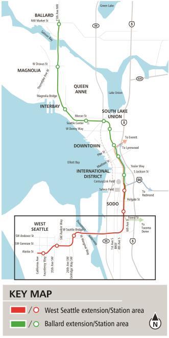
West Seattle and Ballard Link Extensions. Elected Leadership Group
|
|
|
- Jennifer Henry
- 5 years ago
- Views:
Transcription

1 West Seattle and Ballard Link Extensions Elected Leadership Group
2 Agenda Chinatown/ID Station Public comment Engagement, Alternatives, Community Vision, What we heard Delridge Station Public comment Engagement, Alternatives, Community Vision, What we heard 2
3 Alternatives development Alternatives development Early scoping Scoping ST Board identifies preferred alternative and other alternatives Environmental Review Draft and Final Environmental Impact Statement Conceptual Engineering, PE, and Station Planning Board selects project to be built Federal Record of Decision Final route design Final station designs Procure and commission station and public art Obtain land use and construction permits Property acquisition/relocation Groundbreaking Construction updates and mitigation Safety education Testing and preoperations 3


4 Community engagement and collaboration Early Scoping Period EIS Scoping Period 4
 Working group structure focused on engagement and data")

5 Equity and Inclusion Sound Transit & City of Seattle partnership utilizing the Racial Equity Toolkit (RET) Working group structure focused on engagement and data analysis Collaboration to elevate issues and considerations to better inform the alternatives development process Strive to provide information that data alone cannot provide 5
 Source: 2011-2016 American Community Survey, projected in ArcGIS Online WSBLE Community Conditions")
6 Racial Equity Toolkit Level 1 Evaluation Data analysis showed areas of focus; Chinatown/ID and Delridge Determined shared outcomes Updated screening criteria Figure: Concentrated communities of color (non-white population) Source: American Community Survey, projected in ArcGIS Online WSBLE Community Conditions Basemap


7 Racial Equity Toolkit Outcomes Enhance mobility and access for communities of color and low-income populations; Create opportunities for equitable development that benefit communities of color; Avoid disproportionate impacts on communities of color and low-income populations; and Meaningfully involve communities of color and lowincome populations in the project. 7

8 Racial Equity Toolkit Level 2 Evaluation Measured connections, potential impacts and opportunities Gathered and shared community input 8


9 Racial Equity Toolkit Level 3 Scope Chinatown / ID Limit harmful impacts, Maximize connections for all users, and 100-year vision for the station. Delridge Bus-rail integration; and Equitable transit-oriented development serving the community. 9
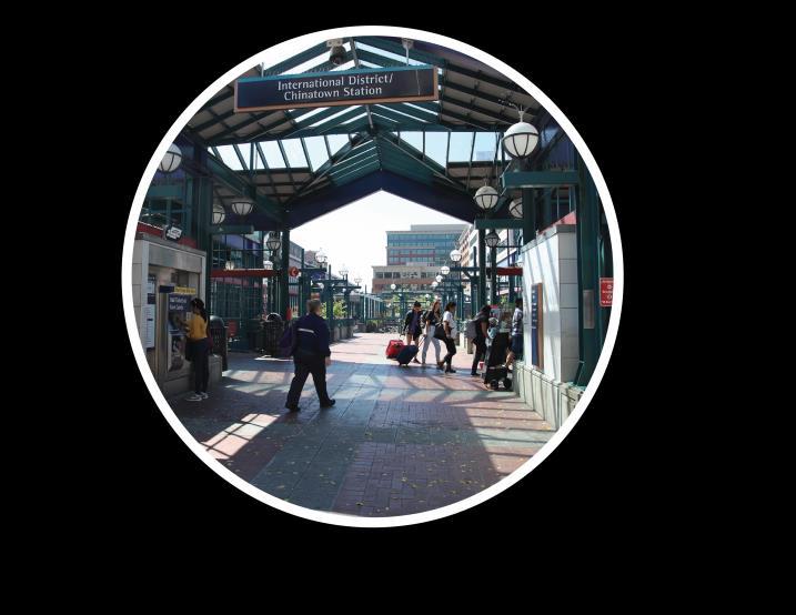
10 Chinatown/ID Station Public Comment
11 Chinatown/ID Station Engagement Overview
12 Types of engagement Forums Briefings/Meetings/Events Listening Sessions Door-to-door outreach with community liaisons Community workshops Open houses & neighborhood forums Social service provider and community organization interviews 12
13 External Engagement Report: C-ID January 2018 March 29, community briefings 5 social service provider interviews 24 door-to-door conversations 4 listening sessions engaging more than 125 community members 9 tabling events engaging more than 770 community members 4 neighborhood forums, workshops and open houses 13
14 C-ID & Pioneer Square briefings C-ID Business Improvement Association (4/12/18, 6/7/18) SCIDpda (4/20/18) InterIm CDA (5/2/18) International Community Health Services (5/8/18) Friends of Little Saigon (5/9/18) CID Forum (5/23/18, 7/25/18, 9/19/18) CID Framework Capital Projects Coordination Work Group (5/25/18, 6/22/18, 9/30/18) Uwajimaya (9/17/18, 1/10/19) SCIDpda Residential Property Managers (12/18/18) Alliance for Pioneer Square, Board of Directors (1/24/19) Seniors in Action Foundation (1/24/19, 3/19/19) Pacific Café (3/19/19) SCIDpda, Board of Directors (3/19/19) Pioneer Square Residents Council (3/19/19) Union Station Tour (5/25/18) International House Senior Living South Downtown Stakeholders (6/12/18, (3/20/19) 6/22/18, 7/12/18, 9/10/18, 1/8/19, 3/4/19) Washington Federal (3/22/19) 14
 Nihonmachi Terrace Apartments (2/20/19) NP Hotel Apartments")
15 C-ID listening sessions Eastern Hotel Apartments (1/29/19) Domingo Viernes, New Central and Jackson Apartments (2/15/19) Nihonmachi Terrace Apartments (2/20/19) NP Hotel Apartments (3/11/19) 15
16 C-ID & Pioneer Square social service provider interviews Chinese Information & Service Center (CISC) (7/30/18) Seniors in Action Foundation (8/1/18) Wing Luke Museum (8/21/18) Real Change (9/14/19) Helping Link (12/5/18) 16
 Tet in Seattle (1/26/19 1/27/19) 2019 SCIDpda C-ID Kick-off Open House (2/7/19) Lunar New Year Celebration (3/2/19) The Publix Building")
17 C-ID tabling events 2018 SCIDpda C-ID Kick-off Open House (2/28/18) Dragon Fest (7/14/18 7/15/18) Celebrate Little Saigon (8/26/18) Night Market (9/8/18) Real Change Vendor Meeting (12/12/18) Tet in Seattle (1/26/19 1/27/19) 2019 SCIDpda C-ID Kick-off Open House (2/7/19) Lunar New Year Celebration (3/2/19) The Publix Building (3/8/19) 17

18 Improve connections (Sounder, Amtrak, Light Rail, Buses) Activate Union Station Minimize Chinatown-ID construction impacts Community Vision Contribute to the community s long-term vision for the future What we have heard 18
 133 attendees 19")
19 Chinatown-International District Station Community Workshop Wednesday, Mar :00 p.m. Union Station (401 S. Jackson St., Seattle) 133 attendees 19
20 Chinatown/ID Station Alternatives


21 Chinatown-ID station area 21
22 Summary of Level 3 alternatives ST3 Representative Project West Seattle Elevated/ C-ID 5th Ave/ Downtown 6th Ave/ Ballard Elevated C-ID station options: 5th Ave Cut-and-Cover and 5th Ave Mined West Seattle Tunnel/ C-ID 4th Ave/ Downtown 5th Ave/ Ballard Tunnel Junction station options: 41st Ave, 42nd Ave and 44th Ave C-ID station options: 4th Ave Cut-and-Cover and 4th Ave Mined Ballard station options: 14th Ave and 15th Ave 22

23 Chinatown-ID station options 23

24 Cut and Cover Station Construction 24

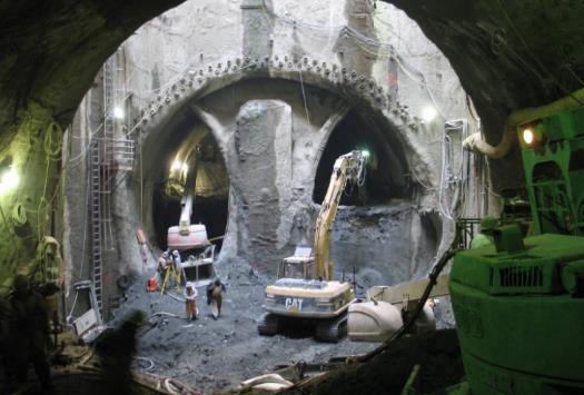
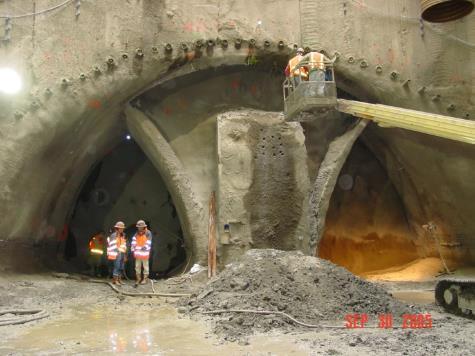
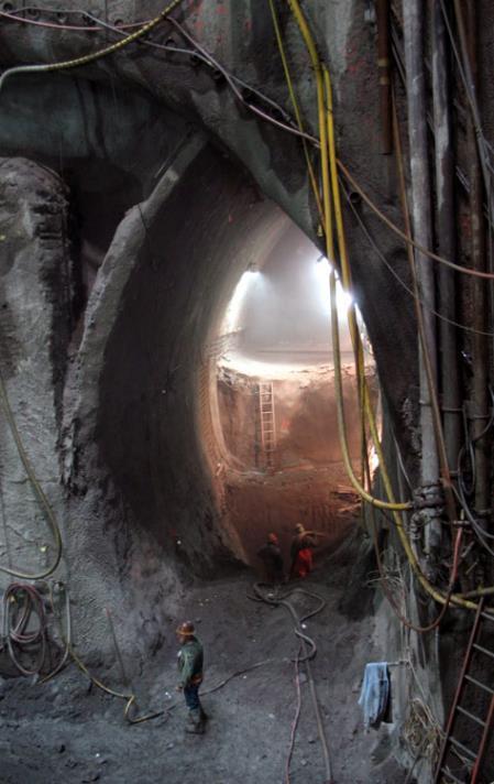
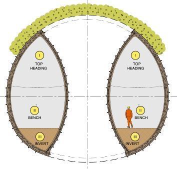
25 Mined Station Construction 25
26 Chinatown-ID station options 26
27 Construction ~ 7 years Detours ~ 1.5 years ST3 Representative Project Cut and cover tunnel 27
28 Chinatown-ID station options 28
29 Construction ~ 6 years Detours ~ 4 months 5th Ave S shallow station 29
30 Construction ~ 7 years Detours ~ none 5th Ave S deep station 30
31 Chinatown-ID station options 31
32 Construction ~ 10 years Detours ~ 7.5 years 4th Ave S shallow station 13
33 Construction ~ 9 years Detours ~ 5 years 4th Ave S deep station 13
34 5th Ave S stations Transfer times 34
35 4th Ave S stations Transfer times 35


36 Chinatown/International District ST3 Representative Project Cut-and-cover tunnel and station on 5th Ave S results in construction effects in C-ID Affects WSDOT ramps/foundations Impacts Ryerson bus base C-ID 5th Avenue Cut-and-cover station on 5th Ave S results in construction effects in C-ID but bored tunnel limits effects Mined station has less convenient access, transfers, potential to extend schedule Affects future Central base expansion Mined station limits train acceleration and track crossovers C-ID 4th Avenue Viaduct rebuild results in more construction complexity, traffic diversions, schedule delays; requires 3 rd Party funding Mined station option increases traffic effects and has less convenient access, transfers and impacts Ryerson bus base Deep mined station does not allow for a pocket track so reduces operability Key considerations 36
37 Key Differentiators Ease of station access/transfers ST3 Representative Project Chinatown-ID 5th Shallow 5th Deep 4th Shallow 4th Deep Higher performing Higher performing Lower performing Higher performing Lower performing Construction effects in C-ID Most construction effects More construction effects Least construction effects More construction traffic effects Most construction traffic effects Property effects Property effects along 5 th Ave in C-ID, affects Ryerson Base Property effects in SODO at tunnel portal and 5 th Ave in C-ID; affects future Central Base expansion Property effects in SODO at tunnel portal and 5 th Ave in C-ID; affects future Central Base expansion Property effects on 4th Ave; affects Ryerson Base Property effects on 4 th Ave; displaces Ryerson Base Construction schedule Does not facilitate track interconnections Meets ST3 schedule Higher schedule risk Potential schedule delay Potential schedule delay Comparative estimate (2018$)* - - $200M - + $300M + $500M** *Compared to ST3 Representative Project **Includes higher Downtown cost of $100M Key differentiators 37
38 Community Vision and Connections
39 39

40 COMMUNITY GOALS & PRIORITIES 40

41 Imagining the future 41

42 Intermodal connections 42

43 Community connections 43

44 Connections to key destinations 44

45 Chinatown/ID Station 4 th Ave N Transit Integration and Non-motorized Access Potential station entry on west side of 4 th could tie in to Weller St overpass, connecting more closely to Sounder/Amtrak and Pioneer Square Longer transfer between light rail stations Longer walk to bus zones, streetcar stop on Jackson Street but closer to 4 th Ave S bus zones Land Use and Development Potential to integrate transfer flows and station entries to support activating Union Station Less potential for equitable Agency TOD, plaza improvements associated with project delivery Guideway and station concepts depicted reflect limited design and shown for illustration and discussion purposes. 45

46 Chinatown/ID Station 5 th Ave N Transit Integration and Non-motorized Access Potential station entry on east side of 5 th could tie into King Street corridor and Chinatown/ID Longer walk to King Street Station, Pioneer Square, bus zones on 4 th Ave S Shorter transfers between light rail stations and closer to Jackson St bus zones and streetcar stop Land Use and Development Potential to integrate transfer flows and station entries to support activating Union Station Higher potential for equitable TOD, plaza improvements associated with project delivery Guideway and station concepts depicted reflect limited design and shown for illustration and discussion purposes. 46
47 What we heard


48 Interest in Chinatown- International District station name Improve connections along Jackson Street, connecting neighborhoods from Little Saigon to the Waterfront Maintain the connected, diverse and historic place supported by an intergenerational, multilingual business and residential community Station can bring more foot traffic to CID businesses Activate streets and buildings around the new station, including Union Station, in a culturally and community-based manner. More green, open spaces, culturally reflective art, public restrooms, local markets/vendors What we have heard Community Vision and Neighborhood Values 48
 Improve connections across 5 th Avenue Improve connections across 4 th Avenue")


49 Concerns about limited parking Convenient and reliable transfers (Sounder, Amtrak, Light Rail, Buses) Improve connections across 5 th Avenue Improve connections across 4 th Avenue Multi-lingual signs, announcements and improved wayfinding could address barriers to using Link Excited about new opportunities to get to more places faster and easier with Sound Transit s system expansion Enjoy connections to family and destinations in Beacon Hill, UW, Eastside and Airport Need good street lighting, security and safe pedestrian experiences What we have heard Maximizing Connections 49


50 Mixed opinions on station location Some prefer 4th Avenue station locations to reconnect the Pioneer Square and C-ID neighborhoods, King Street and Union Stations, and limit potential impacts in the C-ID neighborhood Some prefer 5 th Avenue station locations for easier access from residences and businesses in C- ID and due to shorter construction duration Early, in-language notification about detours and construction impacts Protect the Chinatown Gate What we have heard Building the Station Provide fair compensation and continued operations in C-ID after construction More interest in shallow station options for accessibility and sense of safety Protect local businesses during construction by maintaining operations 50
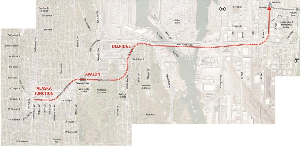
51 Next Steps Share public feedback with SAG/ELG and Board Report back to community on outcomes of alternatives development and RET Continue engagement with communities near station on opportunities to inform the EIS and future station planning Further study urban design concepts in Phase 2 of the project 51
52 ELG discussion
53 Schedule and Next Steps
54 Next steps EIS Scoping Feb 15 April 2 Scoping Input SAG Meeting #13 March 21 Station planning discussions (optional) ELG Meeting #7 March 29 CID and Delridge station focus Summary of key themes from scoping and Level 3 RET memo April 15 For SAG/ELG consideration SAG Meeting #14 April 17 Level 3 recommendations Scoping report finalized April 24 For ELG consideration ELG Meeting #8 April 26 Level 3 recommendations Sound Transit Board System Expansion Committee Sound Transit Board Full Board May 9 May 23 Identify preferred alternative (and other EIS alternatives) Identify preferred alternative (and other EIS alternatives) 54
55 Alternatives development Alternatives development Early scoping Scoping ST Board identifies preferred alternative and other alternatives Environmental Review Draft and Final Environmental Impact Statement Conceptual Engineering, PE, and Station Planning Board selects project to be built Federal Record of Decision Final route design Final station designs Procure and commission station and public art Obtain land use and construction permits Property acquisition/relocation Groundbreaking Construction updates and mitigation Safety education Testing and preoperations 55
56 Delridge Station Public Comment
57 Delridge Station Engagement Overview

58 Types of engagement Forums Briefings/Meetings/Events Community workshops Door to door outreach Open houses & neighborhood forums Social service provider and community organization interviews 58
59 External Engagement Report: West Seattle January 2018 March 29, community briefings 7 social service provider interviews 20 door-to-door conversations 5 neighborhood forums, workshops and open houses 5 tabling events engaging more than 1,290 community members 23 property owner meetings 59
60 West Seattle briefings West Seattle Junction Association (1/24/18, 10/24/18) Nucor Steel (3/7/18) West Seattle JuNO (4/2/18, 4/26/18, 7/26/18, 9/18/18, 11/19/19, 3/25/19) Southwest District Council (4/4/18, 11/7/18) West Seattle Transportation Coalition (4/26/18, 9/27/18) Fauntleroy Business Association (5/24/18) Pigeon Point Neighborhood Council (6/11/18) Drink and Link at Ounces (8/8/18) Delridge Neighborhoods Development Association (10/9/18, 10/24/18, 2/6/19) Feet First West Seattle Light Rail Walk & Talk (10/15/18) Tiburon Condominium, Board of Directors (11/15/18) Youngstown Neighborhood (1/16/19) DNDA Tour (2/6/19) Chelan Café (2/19/19) West Seattle Democratic Women (2/28/19) Pete Spalding (3/1/19) Michael Taylor Judd (3/7/19) Pigeon Ridge Neighborhood Council (3/11/19) 60
61 West Seattle social service provider interviews West Seattle Food Bank (6/28/18) Southwest Youth and Family Services (6/29/18) Neighborhood House at High Point (7/26/18) Downtown Emergency Service Center, Cottage Grove Commons (8/28/18) WestSide Baby (12/6/18) Delridge Community Center (1/9/19) White Center Community Development Association (1/16/2019) 61
 SDOT/Metro RapidRide H Open House (10/10/18) Delridge Community Center (3/9/19) 62")
62 West Seattle tabling events Morgan Junction Festival (6/16/18) West Seattle Summer Fest (7/13/18 7/15/18) Delridge Day (8/11/18) SDOT/Metro RapidRide H Open House (10/10/18) Delridge Community Center (3/9/19) 62
63 Delridge Alternatives Early scoping, level 1 and 2
64 West Seattle/Duwamish ST3 Representative Project 64
65 West Seattle/Duwamish Level 1 Alternatives 65
66 Consider tunnel from Avalon to station at Fauntleroy/ Alaska Isolated Delridge Station Mixed opinions on Junction station location Support for shifting Delridge station south Support for purple alignment Mixed opinions on consolidating stations Support for tunnel in the Junction area Support for northsouth station orientation Consider shifting Golf Course alignment north Mixed opinions on usage of open space West Seattle/Duwamish Public feedback May
 impacts to golf course West Seattle/Duwamish Level 1 Recommendations")
67 Do not carry forward West Seattle Bridge/Fauntleroy Do not carry forward Yancy Street/West Seattle Tunnel Modify alignment to avoid Section 4(f) impacts to golf course West Seattle/Duwamish Level 1 Recommendations 67
68 West Seattle/Duwamish Level 2 alternatives 68

69 Support for a lower height guideway General support for North crossing due to less environmental effects; also interest in minimizing freight effects General support for station that straddles Fauntleroy; tunnel desirable General support for a centrally located tunneled Junction Station at 41 st /42nd Support for locating station east of Junction if elevated. Concern about close station spacing and distance from Junction General support for the offstreet lower height Delridge Station with more development potential Concern about the cost of tunnels West Seattle/Duwamish Public feedback Sep
70 Do not carry forward Oregon Street/Alaska Junction/Tunnel Add a new elevated alternative with Alaska Junction station oriented north/south and Delridge Station further south Do not carry forward Pigeon Ridge/West Seattle Tunnel Do not carry forward Oregon Street/Alaska Junction/Elevated West Seattle/Duwamish Level 2 alternatives 70
71 Level 3 alternatives
72 Summary of Level 3 alternatives ST3 Representative Project West Seattle Elevated/ C-ID 5th Ave/ Downtown 6th Ave/ Ballard Elevated C-ID station options: 5th Ave Cut-and-Cover and 5th Ave Mined West Seattle Tunnel/ C-ID 4th Ave/ Downtown 5th Ave/ Ballard Tunnel Junction station options: 41st Ave, 42nd Ave and 44th Ave C-ID station options: 4th Ave Cut-and-Cover and 4th Ave Mined Ballard station options: 14th Ave and 15th Ave 72

73 ST3 Representative Project West Seattle/Duwamish 73
74 Delridge Station further south Alaska Junction elevated station oriented north/south West Seattle Elevated/ C-ID 5th Ave/ Downtown 6th Ave/ Ballard Elevated West Seattle/Duwamish 74
75 North crossing of Duwamish Delridge Station further south and west Junction tunnel station options 41 st Ave 42 nd Ave 44 th Ave West Seattle Tunnel/ C-ID 4th Ave/ Downtown 5th Ave/ Ballard Tunnel West Seattle/Duwamish 75
 avoidance alternative Delridge Station problematic proximity to freeway/nucor West Seattle Stations West")
 avoidance alternative West Seattle Tunnel Fewer displacements w/ tunnel Alaska")
 avoidance alternative Key considerations West Seattle Stations and")
76 ST3 Representative Project East-west oriented elevated Alaska Junction Station complicates future LRT extension; constrained terminal station on SW Alaska Street High guideway on SW Genesee Street Park effects may require 4(f) avoidance alternative Delridge Station problematic proximity to freeway/nucor West Seattle Stations West Seattle Elevated More displacements between Alaska Junction and Avalon stations; similar number of displacements in Delridge Greatest disruption to neighborhood around Alaska Junction Station High guideway on SW Genesee Street Park effects may require 4(f) avoidance alternative West Seattle Tunnel Fewer displacements w/ tunnel Alaska Junction Station; similar number of displacements in Delridge; Lower Delridge Station in neighborhood Tunnel facilitates lower guideway on SW Genesee St, but could increase implementation schedule and require 3rd Party funding Park effects may require 4(f) avoidance alternative Key considerations West Seattle Stations and Guideway 76

 Guideway height in Delridge Comparative Estimate (2018$)** Avalon/Junction 60 to 90 Delridge Less than 40 Avalon/Junction 25,000 to 35,000 Delridge 25,000 to")
77 Key Differentiators Elevated Alaska/41st Elevated 41 st South of Alaska Tunnel 41 st /Alaska Tunnel 42 nd /Alaska Tunnel 44 th /Alaska Station location (Alaska Junction) Farther away from bus routes on California Ave Farther away from bus routes on California Ave Farther away from bus routes on California Ave Closer to bus routes on California Ave than 41 st Closer to bus routes on California Ave than 41 st and 42 nd Property effects * (Residential units potentially displaced) Property effects * (Sq. ft. of businesses potentially displaced) Guideway height in Delridge Comparative Estimate (2018$)** Avalon/Junction 60 to 90 Delridge Less than 40 Avalon/Junction 25,000 to 35,000 Delridge 25,000 to 35,000 Avalon/Junction 90 to 120 Delridge Less than 40 Avalon/Junction 15,000 to 25,000 Delridge 25,000 to 35,000 Avalon/Junction Less than 30 Delridge Less than 40 Avalon/Junction 5,000 to 15,000 Delridge 75,000 to 85,000 Avalon/Junction Less than 30 Delridge Less than 40 Avalon/Junction 5,000 to 15,000 Delridge 75,000 to 85,000 Avalon/Junction 30 to 60 Delridge Less than 40 Avalon/Junction 5,000 to 15,000 Delridge 75,000 to 85,000 Higher Higher Lower Lower Lower - + $700M + $700M + $700M * Potential displacement numbers are for alternative comparison only and is based on limited engineering and existing conditions. The assessment does not include potential permanent or temporary easements or area for construction staging, traction power substations (TPSS) or underground station entrances. ** Compared to ST3 Representative Project Key differentiators West Seattle Stations and Guideway 77


78 ST3 Representative Project Engineering constraints with Pigeon Point steep slopes Some effects to Duwamish Greenbelt Duwamish Waterway Crossing West Seattle Elevated Engineering constraints with Pigeon Point steep slopes Some effects to Duwamish Greenbelt West Seattle Tunnel North bridge crossing avoids Pigeon Point steep slope and effects to Duwamish Greenbelt Affects freight, port terminal facilities especially during construction Key considerations Duwamish Waterway Crossing 78
 Potential freight movement Potential business and commerce effects Comparative Estimate (2018$)** Affects West Duwamish Greenbelt Harbor Island/South SODO 500,000")
79 Key Differentiators South North Engineering constraints Affects Pigeon Point steep slope Avoids Pigeon Point steep slope Potential fish and wildlife effects Property effects* (Sq. ft. of businesses potentially displaced) Potential freight movement Potential business and commerce effects Comparative Estimate (2018$)** Affects West Duwamish Greenbelt Harbor Island/South SODO 500,000 to 550,000 Delridge 25,000 to 35,000 Lessens freight, port terminal effects Could displace businesses that support trade Avoids West Duwamish Greenbelt Harbor Island/South SODO 400,000 to 450,000 Delridge 75,000 to 85,000 Affects freight, port terminal especially during construction Could displace businesses that support trade; May displace some waterdependent business - + $300M * Potential displacement numbers are for alternative comparison only and is based on limited engineering and existing conditions. The assessment does not include potential permanent or temporary easements or area for construction staging, traction power substations (TPSS) or underground station entrances. **Compared to ST3 Representative Project Key differentiators Duwamish Waterway Crossing 79

80 Community Vision and Connections


81 Delridge corridor context N 81


82 Community planning context 82

83 Delridge Station Level 3 walksheds and current zoning N 83
84 Delridge Station Level 3 Alternative Concepts North of Andover South of Andover North of Genesee N Guideway and station concepts depicted reflect limited design and shown for illustration and discussion purposes. 84

85 Station Context North of Andover 85
86 Station Assessment North of Andover N Transit Integration and Non-motorized Access Direct bus access to station from both sides of street Challenging pedestrian and bike environment due to proximity to West Seattle Bridge ramps Challenging location for passenger pick-up/drop-off Land Use and Development Limited redevelopment opportunities due to proximity to Nucor Steel, West Seattle Bridge ramps, and steep slopes to east Challenging site conditions for affordable housing as part of potential future development Guideway and station concepts depicted reflect limited design and shown for illustration and discussion purposes. 86

87 Station Context South of Andover 87
88 Station Assessment South of Andover N Transit Integration and Non-motorized Access Direct bus access to station from both sides of street Closer to neighborhood destination Potential for ped/bike connections to a possible hill climb at SW Dakota St from 26 th Ave SW Neighborhood Greenway via station Land Use and Development Opportunity for smallerscale redevelopment near station Less potential to translate guideway effects to neighborhood into redevelopment opportunities Guideway and station concepts depicted reflect limited design and shown for illustration and discussion purposes. 88

89 Station Context North of Genesee 89
90 Station Assessment North of Genesee Could require new signalized intersections * Illustrative concept only based on very limited design N Transit Integration and Non-motorized Access Longer connection to station for bus transfers unless buses divert Potential to vacate or reprogram 25 th Ave SW Opportunity to bring 26 th Ave SW Neighborhood Greenway into station Potential opportunity to span Delridge Wy SW with pedestrian bridge and tie into a hill climb on SW Dakota Land Use and Development Largest effect to existing residential neighborhood scale and fabric Largest opportunity for redevelopment that could accommodate amenities such as grocery store and new affordable housing Guideway and station concepts depicted reflect limited design and shown for illustration and discussion purposes. 90

91 Maintain sense of community and diversity (age, income & housing type) Improve integration of all modes: walking, biking, buses and light rail Value neighborhood parks, greenspaces, diverse topography, birds, views and Longfellow Creek Future light rail station should fit with current scale and character of the neighborhood Some support for more small businesses, restaurants, a grocery store, and family friendly amenities Affordable, yet close to downtown What we have heard Community Vision and Connections 91


92 Concerns about height, visual aesthetics and size of future station. Concerns that station is far from neighborhood center and more challenging to access (smaller walkshed, congested area) Concern with visual effects along Pigeon Point and slope stability Some interest in a station location close to the existing bike path near the West Seattle Bridge Considerable concern about neighborhood impacts and residential displacement Some interest in blending station into hillside, minimizing visual impact with potential pedestrian connections to Pigeon Point Some preference for a station location south of SW Andover St to avoid traffic and congestion closer to the West Seattle Bridge Interest in minimizing residential and business displacement and encouraging development that fits with current character of the community What we have heard Level 3 alternatives and station locations 92


93 Interest in using street right of way along Andover/Yancy/Avalon to minimize displacement, avoid greenspace impacts Some interest in station location near the Nucor steel plant Some interest in north crossing to reduce potential effects on Pigeon Point Some interest in station locations farther east minimize residential displacements in Delridge Interest in purple alternative from level 2 to minimize residential displacement, improve bus connectivity and serve the central part of the neighborhood. Interest in pursuing an alternative through a portion of the golf course to minimize residential displacement What we have heard Refinements to Level 3 alternatives and station locations 93
94 Next Steps Share public feedback with SAG/ELG and Board Report back to community on outcomes of alternatives development and RET Continue engagement with communities near station on opportunities to inform the EIS and future station planning Further study urban design concepts in Phase 2 of the project 94
95 ELG discussion
96 Schedule and Next Steps
97 Next steps EIS Scoping Feb 15 April 2 Scoping Input SAG Meeting #13 March 21 Station planning discussions (optional) ELG Meeting #7 March 29 CID and Delridge station focus Summary of key themes from scoping and Level 3 RET memo April 15 For SAG/ELG consideration SAG Meeting #14 April 17 Level 3 recommendations Scoping report finalized April 24 For ELG consideration ELG Meeting #8 April 26 Level 3 recommendations Sound Transit Board System Expansion Committee Sound Transit Board Full Board May 9 May 23 Identify preferred alternative (and other EIS alternatives) Identify preferred alternative (and other EIS alternatives) 97
98 Alternatives development Alternatives development Early scoping Scoping ST Board identifies preferred alternative and other alternatives Environmental Review Draft and Final Environmental Impact Statement Conceptual Engineering, PE, and Station Planning Board selects project to be built Federal Record of Decision Final route design Final station designs Procure and commission station and public art Obtain land use and construction permits Property acquisition/relocation Groundbreaking Construction updates and mitigation Safety education Testing and preoperations 98
99 soundtransit.org/wsblink
Stakeholder Advisory Group Level 2 Recommendations Snapshot
 Stakeholder Advisory Group Level 2 Recommendations Snapshot The following recommendation tables were completed with the West Seattle and Ballard Link Extensions Stakeholder Advisory Group (SAG) during
Early in the scoping process, several groups submitted a letter that reflected our collective values for Sound Transit 3. These values include:
 October 3, 2018 TO: West Seattle and Ballard Link Extension Elected Leadership Group FROM: Transit Access Stakeholders: Transportation Choices Coalition, Futurewise, Feet First, Cascade Bicycle Club, Housing
112th Avenue Light Rail Options Concept Design Report JUNE 2010 PREPARED FOR PREPARED BY TBG PGH
 112th Avenue Light Rail Options Concept Design Report JUNE 2010 PREPARED FOR PREPARED BY TBG060310124909PGH C ontents Introduction 1 Project Overview 1 Public Involvement and Technical Coordination 4 Description
Atlanta BeltLine Corridor Environmental Study. Scoping Meeting August 2008
 Atlanta BeltLine Corridor Environmental Study Scoping Meeting August 2008 What Will We Be Discussing Today? Study Overview - How Did We Get Here? - What Is the Study About? - Who Is Involved? - Where Is
BeltLine Corridor Environmental Study
 BeltLine Corridor Environmental Study Citywide Conversation on Transit and Trails April 2, 2009 Agenda & Introductions Introductions Environmental Study Process Overview of the BeltLine Project BeltLine
Port of Seattle Street Vacations Summary April, 2016
 Port of Seattle Street Vacations Summary April, 2016 Since the question of street vacations provided to the Port was raised at the April 19 Sustainability and Transportation Committee, the Port is providing
Green Line North Centre City Alignment
 Project overview The Green Line will be an important piece of Calgary's transit network, adding 40 kilometres of track to the existing 59 kilometre LRT system. End-to-end, the line will connect North Pointe
Alaskan Way, Promenade, and Overlook Walk Final EIS Appendix D - Supplemental Draft EIS Comments and Responses October 2016.
 B-001-001 The use of Columbia Street for two-way transit was a decision made by King County Metro as part of its Southwest Transit Pathway evaluation. This project is separate from AWPOW. B-001-002 Modeling
What s Up Next In The Seattle Squeeze. PSRC Transportation Policy Board April 11
 What s Up Next In The Seattle Squeeze PSRC Transportation Policy Board April 11 1 Current construction Alaskan Way Viaduct removal Removes the viaduct (including foundations and ramps) and restores the
PLAN ELEMENTS WORKSHOP. April 5, 2016
 PLAN ELEMENTS WORKSHOP April 5, 2016 needs more housing. But there is no one-size fits-all solution. Every neighborhood has its own character. In some places, density is not only appropriate it is badly
I-84 Hartford Project Open Planning Studio #12. April 25, 2017
 I-84 Hartford Project Open Planning Studio #12 April 25, 2017 Meeting Agenda 1. I-84 Hartford Project alternatives update 2. Multimodal station area planning 3. I-84 / I-91 Interchange Study coordination
BeltLine Corridor Environmental Study
 BeltLine Corridor Environmental Study Joint TAC and SAC Meeting December 8, 2008 What We Will Discuss Today Outreach and Agency Coordination Scoping Results Existing Conditions Historical and Archeological
Promoting Economic Development Through Upfront SEPA Review: Lessons from South Downtown Tacoma
 Promoting Economic Development Through Upfront SEPA Review: Lessons from South Downtown Tacoma 1 This session will focus on the City of Tacoma s South Downtown Subarea Plan and associated Non-Project SEPA
Streets, Connectivity & Built Environment Working Group August 2, 2017
 Streets, Connectivity & Built Environment Working Group August 2, 2017 DOWNTOWN OAKLAND SPECIFIC PLAN WELCOME Streets, Connectivity & Built Environment Working Group Social Equity Meeting August 2, 2017
RESOLUTION NO. R Refining the route, profile and stations for the Downtown Redmond Link Extension
 RESOLUTION NO. R2018-32 Refining the route, profile and stations for the Downtown Redmond Link Extension MEETING: DATE: TYPE OF ACTION: STAFF CONTACT: Capital Committee Board PROPOSED ACTION 09/13/2018
The University District envisions, in its neighborhood
 Envisioning the University District Link Light Rail in Seattle s neighborhoods CIY OF SEALE CONCEP-LEVEL SAION AREA PLANNING RECOMMENDAION RESOLUION # 30165 EXHIBI L Vision 08.2000 he University District
Welcome! MILLENNIUM LINE BROADWAY EXTENSION. Over the next 30 years, Metro Vancouver will welcome 1 million new residents and 600,000 new jobs.
 WELCOME Welcome! MILLENNIUM LINE BROADWAY EXTENSION Over the next 30 years, Metro Vancouver will welcome 1 million new residents and 600,000 new jobs. The Broadway Corridor is home to the second largest
Welcome. Green Line LRT. Beltline Alignment Options. Stay engaged! Follow the Green Line story at calgary.ca/greenline
 Welcome Green Line LRT Beltline Alignment Options Stay engaged! Follow the Green Line story at calgary.ca/greenline Green Line LRT Why are we here? Our Challenge Determine the best alignment in the Beltline.
Sustainability, Health, Safety, Recreation & Open Space Working Group August 3, 2017
 Sustainability, Health, Safety, Recreation & Open Space Working Group August 3, 2017 DOWNTOWN OAKLAND SPECIFIC PLAN WELCOME Sustainability, Health, Safety, Recreation & Open Space Working Group Social
City of Tacoma Planning and Development Services
 Agenda Item E-1 City of Tacoma Planning and Development Services To: Planning Commission From: Elliott Barnett, Planning Services Division Subject: Tacoma Mall Regional Center Subarea Plan and EIS Meeting
Planning for TOD Implementation at a Corridor Scale
 Planning for TOD Implementation at a Corridor Scale Catherine Cox Blair, Reconnecting America Presentation to DRCOG and the Sustainable Communities Initiative May 14, 2012 What is Reconnecting America?
Planning Board Briefing
 Planning Board Briefing Why Now? The Sector Plan Implementation Chapter States: Before Stage 1 begins, the following must occur: Approval of the Sectional Map Amendment. Approval of the Greater Lyttonsville
Don Mills Crossing Study and Celestica Lands Development Application Community Meeting, Open House, and Breakout Discussions
 Consultation Summary Don Mills Crossing Study and Celestica Lands Development Application Community Meeting, Open House, and Breakout Discussions This report is not intended to provide a verbatim transcript
Community Open House #2 June 12 th, 2018, 5:30 7:00 PM
 Community Open House #2 June 12 th, 2018, 5:30 7:00 PM Raymond Santiago, GGBHTD Project Manager Consultant Team: Adam Dankberg, Kimley-Horn and Associates Lisbet Sunshine, Civic Edge Consulting 1 Open
SUBJECT: Waterfront Hotel Planning Study Update TO: Planning and Development Committee FROM: Department of City Building. Recommendation: Purpose:
 Page 1 of Report PB-23-18 SUBJECT: Waterfront Hotel Planning Study Update TO: Planning and Development Committee FROM: Department of City Building Report Number: PB-23-18 Wards Affected: 2 File Numbers:
D2 Subway Project Development. Stakeholder Committee October 24, 2018
 D2 Subway Project Development Stakeholder Committee October 24, 2018 1 Agenda Welcome and Introductions D2 Subway Overview Status of Project Development (PD) Efforts Focus Area Workshop Results Potential
Isabel Neighborhood Plan: Alternatives
 Isabel Neighborhood Plan: Alternatives Presented by: Lori Parks, Associate Planner February 2, 2015 Agenda 1. Background on BART to Livermore 2. Isabel Neighborhood Plan 3. Alternative Scenarios 4. General
Northwest LRT Downtown to. Northwest Edmonton Study. Public Workshops
 Northwest LRT Downtown to Northwest Edmonton Study Public Workshops March 23 & 24, 2010 Welcome Thank you all for attending Welcome Introductions Welcome Our Team s Commitment to You for Tonight To provide
Strachan Ave. Overpass Community Design Update. October 26, 2010 Stephen Lipkus Executive Director Georgetown South Project GO Transit
 Strachan Ave. Overpass Community Design Update October 26, 2010 Stephen Lipkus Executive Director Georgetown South Project GO Transit Welcome Program Overview 6:30 8:30 p.m.: Storyboard Review Project
Atlanta BeltLine Subarea 3 Master Plan Update
 Atlanta BeltLine Subarea 3 Master Plan Update April 14, 2018 Workshop Meeting 1 22 miles, connecting 45 neighborhoods 22 MILES of transit 46 MILES of streetscapes and complete streets 33 MILES of urban
The Cambie Corridor 2015 Fall workshop series. What we heard WORKSHOP OUTLINE
 The Cambie Corridor 2015 Fall workshop series W 16 AVE Area 5 CAMBIE CORRIDOR Phase 3 What we heard ovember 21, 2015, 9am-noon, 1:30-4:30pm Peretz Centre 89 Participants* WORKSHOP OUTLIE Introductions
BALLARD TO DOWNTOWN SEATTLE
 TRANSIT EXPANSION STUDY BALLARD TO DOWNTOWN SEATTLE 05/30/2014 FINAL FINAL REPORT This page intentionally left blank Table of Contents Executive Summary... 1 1 Introduction... 1 2 Previous Studies and
Urban Planning and Land Use
 Urban Planning and Land Use 701 North 7 th Street, Room 423 Phone: (913) 573-5750 Kansas City, Kansas 66101 Fax: (913) 573-5796 Email: planninginfo@wycokck.org www.wycokck.org/planning To: From: City Planning
Midtown Corridor Alternatives Analysis. Appendix A - Initially Considered Alternatives Screening
 Midtown Corridor Alternatives Analysis Appendix A - Initially Considered Alternatives Screening Arterial BRT on Lake Street - Overall Rating: RATING Metropolitan Council recommendations stated in the Transportation
Crofton Manor 2803 West 41st Avenue WHAT WE HEARD. Public Consultation: Phase 1
 Crofton Manor 2803 West 41st Avenue WHAT WE HEARD Public Consultation: Phase 1 Background CROFTON MANOR What s Happening The City of Vancouver is undertaking a planning and public engagement process to
2035 General Plan Update and Belmont Village Specific Plan. Joint Study Session with the City Council and Planning Commission April 12, 2016
 2035 General Plan Update and Belmont Village Specific Plan Joint Study with the City Council and Planning Commission April 12, 2016 Agenda 1. Welcome and Introductions 2. General Plan Update Status of
South King County High Capacity Transit Corridor Report. Figure 1-1. Study Area
 Figure 1-1. Study Area 2 Figure 1-2. Sound Transit Long-Range Plan 3 1.2 Goals, Objectives, and the Need for HCT Sound Transit developed a set of HCT guiding principles, goals, and objectives for the Long-Range
BROOKLYN PARK / 85TH AVE LRT STATION CDI DEVELOPMENT GUIDELINES DRAFT
 August 2018 Page intentionally left blank The Brooklyn Park Library adjacent to the 85th Ave LRT Station Area. OVERVIEW The Blue Line LRT Extension / Bottineau corridor offers a unique opportunity to leverage
Workshop 3. City of Burlington Waterfront Hotel Planning Study. September 14, The Planning Partnership
 Workshop 3 City of Burlington Waterfront Hotel Planning Study September 14, 2017 The Planning Partnership The Waterfront Hotel Planning Study 01 The Brant & Lakeshore Planning Study will establish a Strategic
edmonton.ca/ribbonofgreen #ribbonofgreen
 WHAT IS THE RIBBON OF GREEN? The Ribbon of Green is Edmonton s entire river valley and ravine system. The Ribbon of Green (2018) Project will provide strategic guidance for the southwest and northeast
Evaluation Criteria. Detailed Evaluation Criteria
 Evaluation Criteria Detailed Evaluation Criteria Community Well-being A safe and socially inclusive service that improves access to key community destinations and provides transportation choices for Calgarians.
Future Proposed Development
 Future Proposed Development on and around Link light rail s Capitol Hill Station Meeting September 24, 2012 Tonight s Agenda 6:00 pm Open House 6:30 pm Introductions Richard Conlin, City of Seattle Councilmember/Sound
TRANSIT-ORIENTED DEVELOPMENT POLICY DRAFT. City Planning and Development Department Kansas City, Missouri
 TRANSIT-ORIENTED DEVELOPMENT POLICY DRAFT City Planning and Development Department Kansas City, Missouri What is Transit Oriented Development (TOD)? Development that focuses land uses around a transit
D2 Subway Project Development. Public Meeting September 12, 2018
 D2 Subway Project Development Public Meeting September 12, 2018 1 Agenda Project Background Process, Funding and Schedule Project Development (PD) Efforts Preliminary Engineering (PE) Environmental Impact
Relief Line Project Assessment
 Relief Line Project Assessment Stakeholder Advisory Meeting #4 May 30, 2016 Tonight s Meeting PURPOSE To present and discuss: Results of the evaluation of potential alignments Emerging preferred alignment
SAN RAFAEL GENERAL PLAN 2040 INTRODUCTION AND OVERVIEW
 SAN RAFAEL GENERAL PLAN 2040 INTRODUCTION AND OVERVIEW Steering Committee Presentation February 14, 2018 Purpose of General Plan Guide land use and development decisions Coordinate transportation, infrastructure,
Shift Rapid Transit Public Participation Meeting May 3, 2017
 Shift Rapid Transit Public Participation Meeting May 3, 2017 Shift Rapid Transit Initiative Largest infrastructure project in the city s history. Rapid Transit initiative will transform London s public
West Seattle and Ballard Link Extensions. Early Scoping Information Report
 West Seattle and Ballard Link Extensions Early Scoping Information Report February 2018 1. Early Scoping 1.1 Introduction 1.1.1 West Seattle and Ballard Link Extensions Early Scoping: February 2, 2018
Building Great Neighbourhoods. Strathcona
 Building Great Neighbourhoods Strathcona March 21, 2018 Becky Redford Project Manager, Planning & Design Building Great Neighbourhoods Integrated Infrastructure Services Welcome and Purpose To provide
Transit Implementation Strategy Westside Study Group Meeting
 Westside Study Group Meeting February 27, 2012 The Portland Streetcar Passing Through a Park Near Portland State University Westside Study Group Meeting February 27, 2012 1. TIA Update 2. TIS Process To-Date
Equity and Environmental Justice B. MINORITY, ELDERLY, AND LOW INCOME POPULATIONS IN THE STUDY AREA
 Chapter 16: Equity and Environmental Justice A. INTRODUCTION The proposed project alternatives would traverse a large study area that contains a wide range of neighborhoods, residents, and workers. The
Roosevelt Station: Transit-Oriented Development. Workshop #3 - February 22, 2017
 Roosevelt Station: Transit-Oriented Development Workshop #3 - February 22, 2017 Roosevelt TOD NORTH SITE Central Site Available: Early 2020 Parcel Size + 53,000 SF + 1.22 ac Zoning + NC3P-85 + 5.75 FAR
WARM SPRINGS PARK MASTER PLAN
 TABLE OF CONTENTS page 1.0 Introduction and Overview 1 2.0 Information Gathering 2 3.0 Conceptual Alternative Development 8 4.0 Master Plan Development 14 5.0 Construction Cost Estimates 19 LIST OF FIGURES
Slot Home Task Force Meeting #5 Phase 2 June 8, 2017
 Slot Home Task Force Meeting #5 Phase 2 June 8, 2017 MEETING OBJECTIVES Review Staff Recommended Strategy for Mixed Use and Main Street districts Confirm the Strategy for the Mixed Use and Main Street
Study Area. Capitol Way. Greening America s Capitals 11/13/2014. A Greening America s Capitals Project
 Olympia, WA: Greening Capitol Way Supporting Communities move towards sustainability is a priority for the federal government. A Greening America s Capitals Project Office of Sustainable Communities U.S.
East Central Area Plan
 East Central Area Plan Steering Committee Meeting January 10 th, 2019 Tears-McFarlane House Community Room East Central Area Plan Steering Committee Meeting January 10 th, 2019 CHUN Tears-McFarlane House
Equitable Growth Through TOD Planning
 Equitable Growth Through TOD Planning Community Meeting # 2 November 2017 Goals Objectives Extend investment from downtown Connect neighborhoods physically and economically Enhance places based on local
West Broadway Transit Study Initial Screening of Alternatives Memo
 West Broadway Transit Study Initial Screening of Alternatives Memo 5/22/2015 Prepared by the SRF Consulting Group Team for Table of Contents Purpose... 1 Methodology... 1 Screening... 5 Screening Criteria...
Atlanta BeltLine. Subareas 9 & 10. Master Plan Updates. March 26, Washington Park Jamboree 1
 Atlanta BeltLine Subareas 9 & 10 Master Plan Updates March 26, 2018 Washington Park Jamboree 1 22 miles, connecting 45 neighborhoods 22 MILES of transit 46 MILES of streetscapes and complete streets 33
9/19/2018 TODAY S WEBINAR AGENDA CONTINUING EDUCATION UPCOMING TRAINING FROM APBP
 TODAY S WEBINAR AGENDA 3:00 pm: Introduction 3:05 pm: Presentation 3:45 pm: Questions 4:00 pm: Webinar Ends For technical assistance during the webinar: 1-800-263-6317 Choose these prompts: 1, 1, 1 CONTINUING
TOWN COUNCIL / PLANNING COMMISSION
 Workshop #3 TOWN COUNCIL / PLANNING COMMISSION January 20, 2011 Consultant Team In Attendance Tonight BMS Design Group Nevada City and San Francisco Michael Smiley, AICP, ASLA Partner-in-Charge Nancy L.
Transportation Working Team Duane Diggs, Co-Chair (VOICE Buffalo) Kelly Dixon, Co-Chair (GBNRTC) Paul Ray, Facilitator (UB Regional Institute)
 Kelly Dixon, Co-Chair (GBNRTC) Paul Ray, Facilitator (UB Regional Institute)") towards a more sustainable Buffalo Niagara Transportation Working Team Duane Diggs, Co-Chair (VOICE Buffalo) Kelly Dixon, Co-Chair (GBNRTC) Paul Ray, Facilitator (UB Regional Institute) Agenda Welcome,
towards a more sustainable Buffalo Niagara Transportation Working Team Duane Diggs, Co-Chair (VOICE Buffalo) Kelly Dixon, Co-Chair (GBNRTC) Paul Ray, Facilitator (UB Regional Institute) Agenda Welcome,
Eastside Transit Corridor Phase 2 Technical Study Update Community Outreach Meeting February 2017
 Eastside Transit Corridor Phase 2 Technical Study Update Community Outreach Meeting February 2017 Purpose of Tonight s Meeting Recap of Board motion (2014) and technical study process Provide update on
Relief Line Project Assessment
 6/9/2015 Relief Line Project Assessment Stakeholder Advisory Meeting #2 June 9, 2015 Meeting Purpose Report on the Evaluation Results for Potential Station Locations Seek your Input on Potential Corridors
Town Center (part of the Comprehensive Plan)
") Town Center (part of the Comprehensive Plan) Mercer Island Town Center Looking North (2014) In 1994, a year-long process culminated in a set of design guidelines and code requirements for the Town Center
Town Center (part of the Comprehensive Plan) Mercer Island Town Center Looking North (2014) In 1994, a year-long process culminated in a set of design guidelines and code requirements for the Town Center
Chapter 1: Introduction
 Chapter 1: Introduction The Penn Avenue Community Works Corridor Vision and Implementation Framework presents an integrated communitybased vision and a coordinated, long-term implementation framework for
St. Clair Avenue West Area Transportation Master Plan
 1 (Between Keele Street and Old Weston Road) Public Information Centre 1 December 2, 2015 2 Welcome Welcome to the first Public Information Centre for the St. Clair Avenue West Area. The panels will present
This Review Is Divided Into Two Phases:
 Semiahmoo Town Centre Review The purpose of this review: To review the Semiahmoo Town Centre Concept Plan, originally approved in 1993, to ensure that this centre will continue to serve the needs of South
Chapter 1.0 Introduction
 Chapter 1.0 Introduction 1.1 Background The North Metro commuter rail line is part of the RTD FasTracks regional transit system expansion program to build more than 100 miles of rail transit throughout
Community Open House March 26 th, 2018
 Community Open House March 26 th, 2018 Open House Agenda 1. Overview of Planning Process What we heard 2. Future Land Use Policy 3. Priority Growth Areas 4. Plan Elements Making it happen What is a Comprehensive
East Bench Master Plan Update
 Community & Economic Development Office of the Director East Bench Master Plan Update To: From: Planning Commission Wayne Mills, Senior Planner Date: November 18, 2015 CC: Re: Nora Shepard, City Planning
SOUTHWEST TRANSITWAY (STAGE 2) PUBLIC OPEN HOUSE
 PUBLIC OPEN HOUSE") WELCOME! SOUTHWEST TRANSITWAY (STAGE 2) PUBLIC OPEN HOUSE Monday, November 18, 2013 3:30 to 5:30PM and 7:00 to 9:00PM Tuesday, November 19, 2013 3:30 to 5:30PM and 7:00 to 9:00PM Welcome to the Southwest
WELCOME! SOUTHWEST TRANSITWAY (STAGE 2) PUBLIC OPEN HOUSE Monday, November 18, 2013 3:30 to 5:30PM and 7:00 to 9:00PM Tuesday, November 19, 2013 3:30 to 5:30PM and 7:00 to 9:00PM Welcome to the Southwest
Planning for TOD Implementation at a Corridor Scale
 Planning for TOD Implementation at a Corridor Scale Bill Sadler, Reconnecting America Presentation to Gold Line Corridor Working Group July 2, 2013 What is Reconnecting America? Reconnecting America is
DOWNTOWN GEORGETOWN PLANNING STUDY
 DOWNTOWN GEORGETOWN PLANNING STUDY Community Workshop #3 Thursday, May 4, 08 The Planning Partnership OVERVIEW OF STUDY, PROCESS & MILESTONES We are here PURPOSE OF THE STUDY To develop a clear vision
METRO Gold Line BRT CBAC Meeting. August 23, 2018
 METRO Gold Line BRT CBAC Meeting August 23, 2018 1 Today s Topics Introductions Corridor Management Committee Update Public Engagement Update History of Alignment Project Scope Discussions Upcoming CBAC
Port Credit Local Advisory Panel October 20 th Meeting
 Port Credit Local Advisory Panel October 20 th Meeting Focus Of This Evening s Meeting: 1. Hurontario Main Street Higher Order Transit Study 2. Port Credit Mobility Hub & GO Station Parking Structure Study
Welcome to the Sellwood Bridge Project Pre-Construction Open House
 Welcome to the Sellwood Bridge Project Pre-Construction Open House 5:30 7:30 p.m. Please sign in here Information stations and project staff are located throughout the room. Goals for Tonight s Meeting
Aldershot GO Draft Mobility Hub Concepts. East Plains United Church September 13, :30 8:30 pm
 Aldershot GO Draft Mobility Hub Concepts East Plains United Church September 13, 2017 6:30 8:30 pm Today s Agenda 6:30pm: 6:35pm: 7:10pm: 8:10pm: 8:25pm: Opening Remarks Rosa Bustamante, Manager Mobility
Gold Line Bus Rapid Transit Transit Oriented Development (BRTOD) Helmo Station Area Plan
 Helmo Station Area Plan") Appendix F Gold Line Bus Rapid Transit Transit Oriented Development (BRTOD) Helmo Station Area Plan Introduction and Purpose of the Plan The Gold Line Bus Rapid Transit facility is an eleven-mile dedicated
Appendix F Gold Line Bus Rapid Transit Transit Oriented Development (BRTOD) Helmo Station Area Plan Introduction and Purpose of the Plan The Gold Line Bus Rapid Transit facility is an eleven-mile dedicated
SLIDE TITLE TRANSIT-ORIENTED DEVELOPMENT PLAN RED-PURPLE BYPASS STUDY AREA PUBLIC MEETING #2 RED AND PURPLE MODERNIZATION. RPM TOD Plan Update
 SLIDE TITLE TRANSIT-ORIENTED DEVELOPMENT PLAN RED-PURPLE BYPASS STUDY AREA PUBLIC MEETING #2 RED AND PURPLE MODERNIZATION 1 SLIDE TITLE AGENDA Project Introduction TOD s and Development Trends Real Estate
A BLUEPRINT FOR BROCKTON A CITY-WIDE COMPREHENSIVE PLAN
 A BLUEPRINT FOR BROCKTON A CITY-WIDE COMPREHENSIVE PLAN Public Meeting October 2016 1 Plan Summary and Discussion Public Meeting May 4 2017 City of Brockton Bill Carpenter, Mayor Department of Planning
CHAPTER 7: Transportation, Mobility and Circulation
 AGLE AREA COMMUNITY Plan CHAPTER 7 CHAPTER 7: Transportation, Mobility and Circulation Transportation, Mobility and Circulation The purpose of the Transportation, Mobility and Circulation Chapter is to
LOS ANGELES COUNTY METROPOLITAN TRANSPORTATION AUTHORITY (LACMTA)
") CE OF PREPARAT LOS ANGELES COUNTY METROPOLITAN TRANSPORTATION AUTHORITY (LACMTA) NOTICE OF PREPARATION OF AN ENVIRONMENTAL IMPACT STATEMENT (E1S)lENVIRONMENTAL IMPACT REPORT (EIR) TO: AGENCIES, ORGANIZATIONS
CE OF PREPARAT LOS ANGELES COUNTY METROPOLITAN TRANSPORTATION AUTHORITY (LACMTA) NOTICE OF PREPARATION OF AN ENVIRONMENTAL IMPACT STATEMENT (E1S)lENVIRONMENTAL IMPACT REPORT (EIR) TO: AGENCIES, ORGANIZATIONS
MEETING PURPOSE AND OVERVIEW
 MEETING PURPOSE AND OVERVIEW On February 23, 2012, the City of Elk Grove hosted the first of two community workshops related to the Southeast Policy Area. The workshop was held from 6:00 8:30 p.m. in the
1 October Dear Citizens of Charlotte and Mecklenburg County,
 1 October 2011 Dear Citizens of Charlotte and Mecklenburg County, As co-chairs of the Center City 2020 Vision Plan Steering Committee, we are proud to present the Center City 2020 Vision Plan, which sets
SFMTA PHELAN LOOP AND PUBLIC PLAZA PHELAN OCEAN AVENUE
 SFMTA Municipal Transportation Agency Image: a bus in front of the Palace of the Legion of honor SFMTA PHELAN LOOP AND PUBLIC PLAZA PHELAN AVENUE @ OCEAN AVENUE Community Meeting May 23, 2012 San Francisco,
Rapid Transit Implementation Working Group
 Rapid Transit Implementation Working Group October 12, 2017 1 Agenda 1. Consultation Update 2. Technical Work Update 3. LTC Rapid Transit Integration 4. Next Steps 2 Consultation Update 3 Consultation
South Davis County COMMUNITY SPOTLIGHT
 South Davis County COMMUNITY SPOTLIGHT Davis/SLC Community Connector Bus Rapid Transit line connecting SLC & Davis County RTP Phase 1 Project Generate 3,100 average weekday riders Relieve congestion on
SLIDE TITLE. TRANSIT AGENCIES AND COMMUNITY PLANNING Case Study in Supporting TOD with the Chicago Transit Authority TRANSPORT CHICAGO 2017
 SLIDE TITLE TRANSIT AGENCIES AND COMMUNITY PLANNING Case Study in Supporting TOD with the Chicago Transit Authority 1 INTRODUCTION WELCOME Steve Hands, Senior Manager for the Chicago Transit Authority
CITY OF CHARLOTTESVILLE, VIRGINIA CITY COUNCIL AGENDA
 CITY OF CHARLOTTESVILLE, VIRGINIA CITY COUNCIL AGENDA Agenda Date: December 16, 2013 Action Required: Adoption of Resolution Presenter: Staff Contacts: Title: James E. Tolbert, AICP, Director of NDS James
University of Saskatchewan CAMPUS MASTER PLAN. Senate Meeting Preliminary Presentation. April 21, 2018 DIALOG ECS DA WATT
 University of Saskatchewan CAMPUS MASTER PLAN Senate Meeting Preliminary Presentation April 21, 2018 DIALOG ECS DA WATT project process presentation agenda Stakeholder Engagement Project Control phase1
Phase I Redevelopment Plan. First Community Meeting
 Hoboken Terminal and Yard Phase I Redevelopment Plan First Community Meeting May 31, 2011 One Hudson Place Phase I Redevelopment Plan Redevelopment Plan First Community Meeting Agenda 1. Redevelopment
JANUARY 19, 2011 CENTRAL AVENUE-METRO BLUE LINE TRANSIT-ORIENTED DEVELOPMENT IMPLEMENTATION PROJECT COMMUNITY FORUM
 CENTRAL AVENUE-METRO BLUE LINE TRANSIT-ORIENTED DEVELOPMENT IMPLEMENTATION PROJECT COMMUNITY FORUM JANUARY 19, 2011 THE MARYLAND-NATIONAL CAPITAL PARK AND PLANNING COMMISSION PRINCE GEORGE S COUNTY PLANNING
CITYWIDE PLANNING DIVISION
 2014-2019 CITYWIDE PLANNING DIVISION a five-year work program for long-range planning November 2016 TODAY S PRESENTATION 1. Overview 2. Planning Priorities 3. Topics/Focus Areas 5. Essential Practices
Create Policy Options Draft Plan Plan Approval. Public Consultation Events. Phase 2
 Background Grandview-Woodland Community Plan In the spring of 2012, the City of Vancouver embarked on a comprehensive community planning program in the Grandview-Woodland neighbourhood. The process has
Key Themes and Responses May 2016
 King and Victoria Transit Hub and Waterloo Street Pedestrian Access Key Themes and Responses May 2016 The following summarizes what Regional staff heard about the King Victoria Transit Hub and Waterloo
South King County High Capacity Transit Corridor Report. Figure Other Infrastructure
 South King County High Capacity Transit Corridor Report Figure 3-10. Other Infrastructure 30 Shorelines and Critical Areas The corridor is framed by three major water bodies: Puget Sound to the west, Elliott
Public input has been an important part of the plan development process.
 Lakewood s Comprehensive Plan recognizes that transportation helps shape the community, and that the way the community provides for the safe and efficient movement of people affects the character of the
East Corridor Final Environmental Impact Statement
 East Corridor Final Environmental Impact Statement Alternatives Considered Operating Plan The requirements for opening day operations versus year 2030 are based on ridership and operations. Opening day
October 25 Downtown Partnership and Action Plan Workshop Record of Group Table Results
 October 25 Downtown Partnership and Action Plan Workshop Record of Group Table Results During the October 25 workshop, participants were asked to rank their top priorities for the Downtown Action Plan.