Visual Assessment of Scenic Design (SD) Combining Zone Removal and SLU Additions Along Scenic Highway 12 Part Two
|
|
|
- Diane Stevens
- 6 years ago
- Views:
Transcription

1 County of Sonoma, Permit and Resource Management Department Visual Assessment of Scenic Design (SD) Combining Zone Removal and SLU Additions Along Scenic Highway 12 Part Two Focusing on the State Designated Scenic Highways 12 Denise Peter, AICP
2 Table of Contents Summary... 4 Methodology... 4 Sonoma Valley (State Scenic Highway 12)... 5 Area 1: Rincon Valley County Islands... 5 Overview Map... 5 Hwy 12 at Maria Lane... 6 Hwy 12 at St Francis Road... 7 Hwy 12 near Fairway Drive... 9 Hwy 12 near Mountain Hawk Way (looking east toward Sunhawk Dr) Area 2: Wildwood Road Area Topographic and Overview Map Prior Zoning Map Hwy 12 at Mountainhawk Way (eastbound view) Hwy 12 at Los Alamos Rd (looking east) Hwy 12 at Richards Rd (looking east) Hwy 12 at Melita Rd (westbound view) Area 3: Frey/Lawndale/Hoff Roads Area Overview Map Hwy 12 at Frey Road (westbound view) Hwy 12 at Adobe Canyon Road (westbound view) Hwy 12 near Lawndale Rd (eastbound view) Area 4: Kenwood Overview and Land Use Maps Kenwood Strip Commercial Area near Cypress Ave (westbound view) Hwy 12 near Randolph Avenue (eastbound view) Area 5: Adine/Sylvia/Bonnie Way Area Overview Map Hwy 12 near Nuns Canyon Road (eastbound view) Hwy 12 near Weise Road (eastbound view) Hwy 12 near Sylvia Dr (eastbound view) Hwy 12 near Trinity Road (westbound view) Area 6: Glen Ellen LADG Area Overview Map Hwy 12 near Arnold Drive (westbound view) Area 7: London Ranch/Hill Road Area Overview & Prior Zoning Map Hwy 12 near Arnold Drive (eastbound view) Hwy 12 near Madrone Road (westbound view) Area 8: Morningside Mountain/El Rancho Feliz/Heaven Hill/Sobre Vista Topography Map Overview & Prior SD Zoning Map Hwy 12 at Madrone Road (looking westerly down Madrone Road) Hwy 12 near Serres Lane (looking westerly) Page 2
3 Hwy 12 near Serres Drive (looking westerly down Serres Drive) Arnold Drive near El Rancho Feliz Road (looking westerly) Area 9: Eldridge Overview Map Hwy 12 at Madrone Road (looking westerly down Madrone Road) Area 10: Arnold/Serres/12/Agua Caliente Area Overview Map Hwy 12 west of Agua Caliente (looking westerly) Hwy 12 east of Madrone Road (eastbound view) Hwy 12 east of Serres Lane (eastbound view) Area 11: Rancho Bonita/Cavedale Overview Map Highway 12 near Rancho Bonita Way (eastbound view) Hwy 12 west of Cavedale (westbound view) Hwy 12 at El Portola and Moon Mountain Drives (eastbound view) Hwy 12 near London Way (westbound view) Area 12: Agua Caliente Road/Hwy 12/Verano/Arnold Area (The Springs) Overview Map Page 3
4 Summary The Permit and Resource Management Department proposes to eliminate the Scenic Design (SD) Combining Zone which has been used to implement the open space policy and maps of Area Plans. SD zoning was established in the zoning code in the 1960 s. The reason for removal is that many of the Area Plans have been repealed or are planned for repeal, and SD zoning refers to policies in an Area Plan. Area Plans were prepared between the mid-1970 s and mid-1980 s and are now largely built out, redundant with the General Plan and/or obsolete. In some instances, properties within the SD zone would have better scenic resource protection if the lands were added to an adjacent General Plan Scenic Landscape Unit (SLU) and rezoned to the Scenic Resource (SR) combining zone. The SR Combining Zone was established in 1992 and is redundant with the purpose of SD zoning. The SR zone has specific development standards such as not building on ridgelines, and minimizing grading and tree removals. The General Plan requires SR zoning on Scenic Landscape Units, Community Separators, and Scenic Corridors. This report provides additional assessment of views from Highway 12 as requested by the Sonoma County Planning Commission at the public hearing of September 5, Of the twelve SD areas assessed in this report that were previously not recommended for SLU/SR designation as a replacement for SD, three are now being recommended: Area 2: Wildwood Road Area, Area 7: London Ranch/Hill Road Area, and Area 8: Morningside Mountain/El Rancho Feliz/Heaven Hill/Sobre Vista. Methodology Staff has analyzed all of the areas proposed for SD removal using the Permit and Resource Management Department s mapped Geographic Information Systems resources, and the three dimensional mapping capabilities of Google Earth. PRMD s GIS map layers were converted to Google Earth map layers and viewed in three dimensions from various street view locations to assess the relative visibility of large landforms from public roads. The following colors highlight open space designations, zoning and other features in the Google Earth images used in this study: Pink/purple Scenic Design (SD) zoning Light Green Scenic Landscape Unit (SLU) General Plan Open Space Designation Dark Green Parkland Red Community Separator (CS) General Plan Open Space Designation Grey City Limits Orange Proposed Scenic Landscape Unit and SR zoning, or remove SD and replace with SLU/SR as presented to the Planning Commission on 9/5 Yellow Existing Scenic Resource (SR) zoning Page 4

5 Sonoma Valley (State Scenic Highway 12) The following Highway 12 photographs and images are sequenced from Santa Rosa to Sonoma, with staff s recommended General Plan and/or zoning change. Area 1: Rincon Valley County Islands This area is entirely within the City of Santa Rosa s Urban Growth Boundary and will be annexed to Santa Rosa in the future. These parcels are mostly built out with regard to the County s zoning. If annexed, the parcels would gain increased development potential and all land use permits would be issued by the City of Santa Rosa. Staff recommendation: Remove SD zoning from these parcels because they are mostly built out and many are not visible from Highway 12. Additionally General Plan Objective OSRC-2.1 states that the inclusion of Scenic Landscape Units within the spheres of influence of public service providers (i.e. areas that have public sewer and water) should be avoided. Removal of SD zoning would have negligible visual impact from Hwy 12. Visibility of this area from several Hwy 12 viewpoints is discussed below. Overview Map Rincon Valley County Islands Page 5


6 Hwy 12 at Maria Lane The Maria Lane area within Santa Rosa s Urban Service Area is almost entirely built out. Most of the lots on Maria Lane are not visible as they are behind existing homes adjacent to Hwy 12. Page 6

7 Hwy 12 at St Francis Road These 3 pockets of developed rural and suburban residential lots are screened from Hwy 12 views by fencing, vegetation and existing development. Page 7


8 Hwy 12 at St Francis Road (continued) This view from Hwy 12 shows this existing developed suburban residential area within Santa Rosa s Urban Growth Boundary. The character of this suburban area is not appropriate for inclusion within a County Scenic Landscape Unit because of its urbanized condition. Page 8


9 Hwy 12 near Fairway Drive This area has reached its maximum subdivision potential until annexed by City of Santa Rosa. Larger parcel ( ) in this area is ~8 acres and is developed with a home. As seen from this view, the Fairway Drive area is a developed suburban/rural area with mature tree screening and the retention of SD and the requirement for design review for minor expansions on these lots, such as room additions, will have negligible impact on the scenic character of Hwy 12 at this location. Page 9


10 Hwy 12 near Mountain Hawk Way (looking east toward Sunhawk Dr) The upper portion of this aerial photo shows lots off of Sunhawk Drive entirely within the City of Santa Rosa s Urban Growth Boundary. These lots are adjacent to the County s Community Separator and not a part of it. These sets of images illustrate that this area of lots near Sunhawk Drive is not visible from Hwy 12 due to its long distance from Hwy 12, elevation and topography, and screening by exisiting development and vegetation. Page 10


11 Area 2: Wildwood Road Area This area includes parcels previously zoned SD which appear to have had the SD inadvertently removed. These areas appear as ridgelines from Highway 12 and should be treated as if the SD existed as they are surrounded by similar topography which is either now designated as Community Separator, Scenic Landscape Unit or zoned SD. Staff recommendation: Designate parcels in this area for Scenic Landscape Unit and SR zoning to be consistent with similarly designated parcels and avoid leaving an unprotected ridgeline and hillsides. Topographic and Overview Map Page 11

12 Prior Zoning Map The parcels in this area were zoned SD in With the conversion of the paper zoning maps to digital form in 2008, it appears that the SD for this area was inadvertantly removed. The only project since 2008 that removed SD was done in conjunction with parcels that had SR zoning with the intent that no parcel would have both SD and SR zoning, and if there was no SR zoning, the SD would be retained. Page 12
 These images")

13 Hwy 12 at Mountainhawk Way (eastbound view) These images show the visibility of this ridgeline and hillside from Highway 12. Page 13
 These images")

14 Hwy 12 at Los Alamos Rd (looking east) These images show the visibility of this ridgeline and hillside from Highway 12. Page 14
 These images show the")

15 Hwy 12 at Richards Rd (looking east) These images show the visibility of this ridgeline and hillside from Highway 12. Page 15
 These images show the")

16 Hwy 12 at Melita Rd (westbound view) These images show the visibility of this ridgeline and hillside from Highway 12. Page 16
17 Area 3: Frey/Lawndale/Hoff Roads Area This area wraps around a portion of Community Separator just to the east of the Oakmont community in the City of Santa Rosa. The area is flat and on both west and east sides has riparian corridors which provide some screening from east and westbound Highway 12 views. Tall property line vegetation perpendicular to Highway 12 also screens buildings from Highway 12 views. A Scenic Corridor is located along Highway 12 requiring building setbacks of 30% of the lot depth to a maximum of 200 feet. The area slopes downward from Highway 12 toward streams along the east and west edges resulting in minimal visibility from Highway 12. The portions of this area that are closest to Highway 12 are mostly built out with rural residential development on 1 to 2 acre lots with mature screening vegetation and trees. Staff recommendation: Remove SD zoning from these parcels because they are mostly built out and many are not visible from Highway 12 because of flat topography and low elevation, existing development and screening by existing vegetation and development. Removal of the SD zoning would result in negligible visual impacts as viewed from Highway 12. Removal of SD zoning would have negligible visual impact from Hwy 12. Visibility of this area from several Hwy 12 viewpoints is discussed below. Page 17

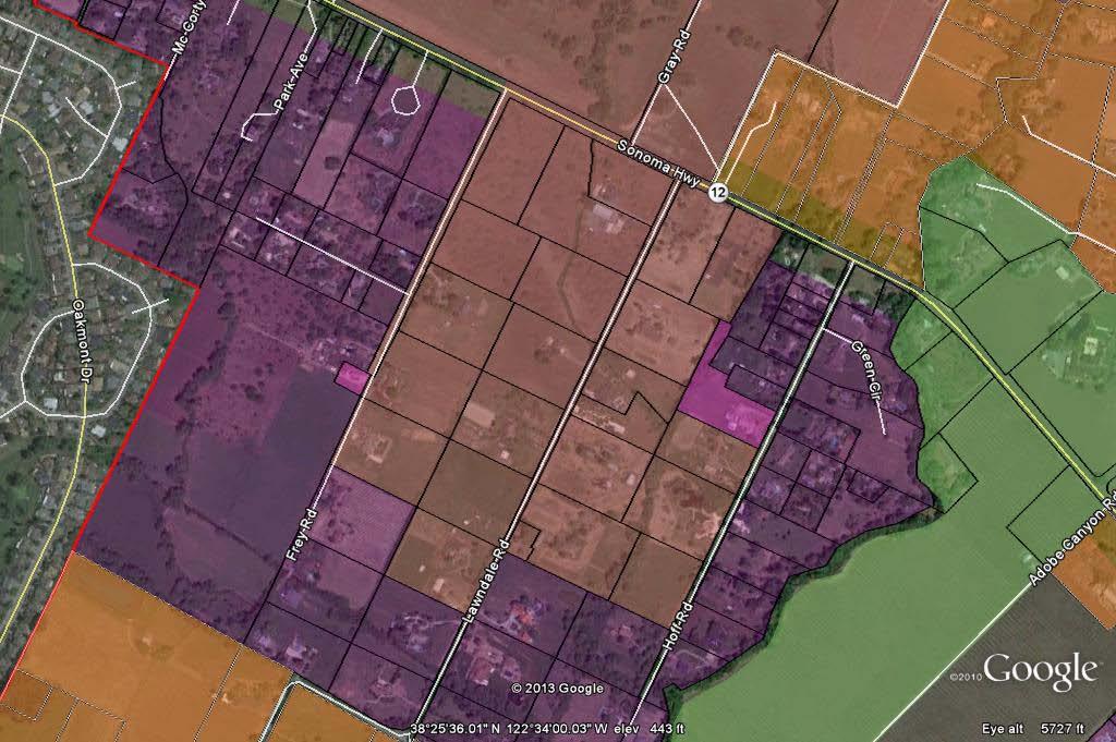
18 Overview Map Frey/Lawndale/ Hoff Roads Area Page 18


19 Hwy 12 at Frey Road (westbound view) Westbound Highway 12 view just east of Frey Road looking past Community Separator area (red) toward purple SD zoned area which is screened by property line vegetation and trees. Page 19

 is not visible")
20 Hwy 12 at Adobe Canyon Road (westbound view) Westbound Highway 12 at Adobe Canyon Road showing purple SD zoned area from a more open area that provides a longer time period of viewing because of lack of roadside trees and vegetation. The flat purple SD zoned area just beyond the existing Scenic Landscape Unit (green) is not visible because it is behind a tall canopy of riparian vegetation and trees. Page 20

 is not visible because it is behind a tall canopy of")
21 Hwy 12 near Lawndale Rd (eastbound view) Eastbound Highway 12 view just east of Lawndale Road showing purple SD zoned area. The flat purple SD zoned area just beyond the existing Community Separator (red) is not visible because it is behind a tall canopy of riparian vegetation and trees. Page 21


22 Area 4: Kenwood Although on private septic systems and a small public water company (Kenwood Village Water Company), this community has a very compact rural pattern of development with the majority of lots at a quarter acre in size. The community is mostly built out and is in a flat area with mature vegetation and trees. Lots fronting Highway 12 are designated in the General Plan for Limited Commercial development which requires design review and/or use permit. Scenic Corridor building setbacks of 30% lot depth to a maximum of 200 feet are also in effect. The residential development behind the Highway 12 strip of commercial is screened from Highway 12 views. Staff recommendation: Remove SD zoning from these parcels because they are mostly built out, residential development is not visible from Highway 12, and the strip commercial adjacent to Highway 12 is subject to both Scenic Corridor and commercial design review. Additionally General Plan Objective OSRC-2.1 states that the inclusion of Scenic Landscape Units within the spheres of influence of public service providers (i.e. areas that have public sewer and/or water) should be avoided. Removal of SD zoning would have negligible visual impact from Hwy 12. Visibility of this area from several Hwy 12 viewpoints is discussed below. Overview and Land Use Maps Image above left shows purple SD zoning proposed for removal, surrounded by orange SD zoning proposed for replacement with Scenic Landscape Unit designation as discussed in the prior Visual Assessment Report presented to the Planning Commission on September 5, Image above right shows General Plan land use categories. Bright green strip along Hwy 12 is commercial. Aqua small lot area is residential one acre density. Slightly larger lots in the uper left corner are rural residential. Remaining larger lots are agricultural land use. Page 22

 to indicate that Scenic Corridor setback restrictions and/or Design Review is in effect.")
23 Kenwood Strip Commercial Area near Cypress Ave (westbound view) These images show the character of the Kenwood Highway 12 strip commercial area. Many of the commercial buildings in this area pre-date the County s first building and zoning codes from the early 1960 s, and have been allowed to be maintained in their original locations. Along both sides of Highway 12 for a distance of 200 feet from the centerline, there is no SD zoning. Instead the area is zoned Scenic Resource (SR) to indicate that Scenic Corridor setback restrictions and/or Design Review is in effect. The SD zoning behind the 200 foot strip of SR zoning is not visible due to existing development and vegetation. Page 23


24 Hwy 12 near Randolph Avenue (eastbound view) These images show a character of development similar to that described on the previous page. Visual impacts associated with SD removal for the purple SD zoned area would also be negligible. Page 24


25 Area 5: Adine/Sylvia/Bonnie Way Area This area is built out with the exception of one lot in the Hwy 12 Scenic Corridor that would be subject to Design Review. A row of homes back onto Hwy 12 and are screened by fencing and vegetation. Remainder of area would not be visible because of flatness of this area and location behind existing homes along Hwy 12. Staff recommendation: Remove SD zoning from the parcels shown in purple because the area is built out and building remodels or room additions would not be visible from Hwy 12 or would be subject to design review due to location in the Hwy 12 Scenic Corridor 200 foot strip area. Visibility from several Hwy 12 viewpoints is discussed below. Removal of SD zoning would have negligible visual impact from Hwy 12. Overview Map Page 25
 Area with SD zoning (purple) is")

26 Hwy 12 near Nuns Canyon Road (eastbound view) Area with SD zoning (purple) is screened from Hwy 12 views at this location due to topography and vegetaton. Page 26


27 Hwy 12 near Weise Road (eastbound view) Area of SD zoning (purple) is not visible from Hwy 12 at this location as it is behind a dense riparian corridor providing screening. As recommended at the 9/5/13 Planning Commission public hearing, the parcels at this bend in the highway that are heavily vegetated and contain the riparian corridor should have the SD zoning replaced with Scenic Landscape Unit Designation as a better method of scenic resource protection. Page 27


28 Hwy 12 near Sylvia Dr (eastbound view) SD zoned area (purple) would not be visible from Highway 12 because there is a 200 foot strip of Scenic Corridor and Scenic Resource zoning separating existing development from Hwy 12 views. Homes which back onto Hwy 12 and are visible are already subject to design review. Page 28


29 Hwy 12 near Trinity Road (westbound view) SD zoned area (purple) would not be visible from Highway 12 because there is a 200 foot strip of Scenic Corridor and Scenic Resource zoning separating existing development from Hwy 12 views. Homes which back onto Hwy 12 and are visible are already subject to design review. Page 29

30 Area 6: Glen Ellen LADG Area This area is entirely within an Urban Service Area and within the Glen Ellen Local Area Development Guidelines. The area is mostly built out and located at least a half mile from Hwy 12 at lower elevations near riparian corridors or screened by intervening rolling topography. Staff recommendation: Remove SD zoning from these parcels (shown in purple within the red boundaries) because they are mostly built out and not visible from Highway 12. These parcels are also in the Glen Ellen Subarea 1 (requiring design review for ministerial and discretionary permits) and Glen Ellen Subarea 2 (requiring design review for discretionary permits). Additionally General Plan Objective OSRC-2.1 states that the inclusion of Scenic Landscape Units within the spheres of influence of public service providers (i.e. areas that have public sewer and water) should be avoided. Removal of SD zoning would have negligible visual impact from Hwy 12. Visibility of this area from several Hwy 12 viewpoints is discussed below. Overview Map Area subject to Glen Ellen Local Area Development Guidelines shown within red boundary. Glen Ellen Area Subarea 1 is the inner area adjacent to Arnold Drive. Subarea 2 is the outer boundary. Page 30


31 Hwy 12 near Arnold Drive (westbound view) Note Glen Ellen Subareas 1 & 2 shown as solid red to illustrate general location. Not all parcels in Glen Ellen LADG are zoned SD. The red area would not be visible from Highway 12 due to the existing wooded hillsides and mature trees on land between Highway 12 and Glen Ellen. The entrance into Glen Ellen (Arnold Drive) is a Scenic Corridor with a 200 foot strip of Scenic Resource zoning which will serve to protect screening vegetation and trees which block views of Glen Ellen from Hwy 12. Page 31
32 Area 7: London Ranch/Hill Road Area This area is just above and to the west of the Glen Ellen Local Area Development Guidelines boundary. It is mostly developed with lots in the ten acre range. This area is in the foothills below Jack London State Park and is of a hilly topography with a unique stand of very tall redwood and fir on a ridgeline that can be seen across the Sonoma Valley floor from Highway 12 westbound. Several of the parcels in this area historically had SD zoning which was inadvertently dropped from the electronic Zoning Database and should be treated as if they had SD zoning particularly as they are located on a ridge in a location visible from Highway 12. Staff recommendation: Replace the SD zoning on these parcels with Scenic Landscape Unit and Scenic Resource (SR) zoning to protect the ridgeline and hillside views from Highway 12 westbound. The SR zoning will particularly help to preserve the unique and significant stand of mature redwoods and fir located on a ridgeline as viewed from Scenic Highway 12. Visibility of this area from several Hwy 12 viewpoints is discussed below. Page 32


33 Overview & Prior Zoning Map These parcels should have had SD zoning. See historical zoning map below. Zoning Map Prior to Conversion to Electronic Zoning Database. Page 33

34 SD SD SD Note: Area of London Ranch/Hill Road is purple area above the red area and parcels marked SD that were historically zoned SD. This area is mostly built out. Page 34


35 Hwy 12 near Arnold Drive (eastbound view) Glen Ellen Local Area Development Guidelines area shown in red. Proposed purple SD area to be replaced with SLU/SR shown in purple. This image illustrates that the existing SD zoned area in purple would not be visible from Highway 12 eastbound. The area in red is subject to the Glen Ellen Local Area Development Guidelines and is discussed in the prior section. Page 35


36 Hwy 12 near Madrone Road (westbound view) Redwood/Fir Grove on ridge above Glen Ellen This image illustrates the visibility of the ridgeline Redwood/Fir Grove above Glen Ellen. The purple SD zoned area for the London Ranch/Hill Road area is barely noticeable from this angle because it is located on a ridge and from this angle only appears as a thin strip. However, because of its ridgeline prominenance and unique tree profile, it contributes to the visual character of the Scenic Highway 12 corridor. SD zoning for this purple strip should be replaced with Scenic Landscape Unit and Scenic Resource zoning. Page 36
37 Area 8: Morningside Mountain/El Rancho Feliz/Heaven Hill/Sobre Vista This area consists of rural residential lots in the 2 to 10 acre density range. This area contains a strip of parcels without SD zoning at the highest elevations. The SD zoning was inadvertently left off, as the paper zoning maps prior to 2007 clearly show these lots zoned as SD. These lots without SD or SR zoning are among the most visible because of their higher elevation and unique redwood/fir clusters that can be seen from Highway 12 across the valley. Staff recommendation The images on the following pages show the visibility of this rural residential foothill area with lots in the Rural Residential 2 to 10 acre density category. This area is quite visible along the entire length of Madrone Road and from Hwy 12 particularly where vineyards provide expansive views across the Sonoma Valley. It is rarely visible from Arnold Drive. Replacement of the existing SD zoning with SR is recommended for this entire area because of the potential for visual degradation of the Scenic Highway 12 corridor from tree removal, unshielded night time lighting, inappropriate structure and road placement, and materials and colors that contrast significantly with the vegetative cover. Visibility of this area from several Hwy 12 viewpoints is discussed below. Page 37

38 Topography Map This area contains an intermediary ridgeline of 400 to 600 feet in elevation which is below the Sonoma Mountain ridgeline of approximately 2,000 feet. Page 38
 zoning associated with Scenic Landscape Units.")
39 Overview & Prior SD Zoning Map This image shows the Scenic Design (SD) zoned area (within red border) on the west side of Arnold Drive of Morningside Mountain/El Ranch Feliz/Heaven Hill/Sobre Vista Roads. Jack London State Park and Sonoma Valley Regional Park are to the immediate north. The yellow shade indicates the existing Scenic Resource (SR) zoning associated with Scenic Landscape Units. The yellow/orange shade represents Scenic Resource (SR) zoning associated with Community Separators. The following pages show an enlargement of this area, and a narrow strip of unshaded property between the SR and SD zoning that inadvertantly had the SD removed which existed in 2007 prior to conversion of the paper zoning maps to the electronic Zoning Database. Page 39

 was extended to match the")
40 Areas where SD zoning inadvertently removed after 2007 Areas where SD zoning inadvertently removed after 2007 The unshaded parcels were inadvertantly dropped from the SD zone. The historical zoning maps are shown on the next page. This strip of unshaded parcels should be treated as if they are zoned as SD. It is recommended that this area of SD (purple) and historically zoned SD parcels be added to the adjacent Scenic Landscape Unit and zoned Scenic Resource (SR). Note that at the 9/5/13 Planning Commission meeting, the Commission recommended that the Scenic Landscape Unit designation (shown as the darker shade of yellow) was extended to match the existing SR zoning (lighter yellow) here and in other areas where this inconsistency exists. Page 40
 indicating that strip of unshaded")

41 Visual Assessment of Scenic Design (SD) Combining Zone Removal Historic zoning maps (2007) indicating that strip of unshaded parcels between SR and SD zoning on previous page should be considered to have SD zoning because the SD zoning was inadvertantly removed. Page 41

42 Historic zoning maps (2007) indicating that strip of unshaded parcels between SR and SD zoning on previous page should be considered to have SD zoning because the SD zoning was inadvertantly removed. Page 42


43 Hwy 12 at Madrone Road (looking westerly down Madrone Road) Area where SD inadvertently removed Morningside Mountain/El Rancho Feliz/Heaven Hill/Sobre Vista SD Area Area where SD inadvertently removed These images show the visibility of this rural residential foothill area with lots in the Rural Residential 2 to 10 acre density category. This area is quite visible along the entire length of Madrone Road and from Hwy 12 particularly where vineyards provide expansive views across the Sonoma Valley. Replacement of the existing SD zoning with SR is recommended for this entire area because of the potential for visual degradation of the Scenic Highway 12 corridor from tree removal, unshielded night time lighting, inappropriate structure and road placement, and materials and colors that contrast significantly with the vegetative cover. Page 43


44 Hwy 12 near Serres Lane (looking westerly) Area where SD inadvertently removed 1,200 foot wide by ~ 3 mile long strip of SLU/SR inconsistency recommended for correction by PC on 9/5/13 Arnold Drive SD area above Arnold Drive at a higher elevation is recommended for SLU/SR designation because of its visibility from Highway 12. Page 44

45 Hwy 12 near Serres Drive (looking westerly down Serres Drive) Arnold Drive The Morningside Mountain/El Rancho Feliz/Heaven Hill/Sobre Vista area above Arnold Drive is not visible at this location from The Springs urbanized area due to existing trees. Page 45

 is rarely visible")
46 Arnold Drive near El Rancho Feliz Road (looking westerly) A 200 foot wide band of Scenic Resource zoning is in effect along Arnold Drive. Due to topography and existing trees, the Morningside Mountain/El Rancho Feliz/Heaven Hill/Sobre Vista area (shown in purple above) is rarely visible from Arnold Drive. Page 46
47 Area 9: Eldridge This area is entirely within the Sonoma Valley Urban Service Area. The area is flat, mostly built out and over a half mile from Hwy 12. It is at an elevation lower or similar to Highway 12, and screened from Highway 12 by the Sonoma Creek riparian corridor. Staff recommendation: Remove SD zoning from these parcels because they are mostly built out and not visible from Highway 12. Additionally General Plan Objective OSRC-2.1 states that the inclusion of Scenic Landscape Units within the spheres of influence of public service providers (i.e. areas that have public sewer and water) should be avoided. Removal of SD zoning would have negligible visual impact from Hwy 12. Visibility of this area from several Hwy 12 viewpoints is discussed below. Page 47


48 Overview Map Note: Eldridge is within a County Urban Service Area. Note: General Plan designation for majority of Eldridge is Urban Residential and built out. Page 48


49 Hwy 12 at Madrone Road (looking westerly down Madrone Road) Eldridge Note: Eldridge area is shown in purple as flat area in front of the foothills purple area. Eldridge village is not visible from Highway 12 due to screening from Sonoma Creek riparian corridor. Page 49

50 Area 10: Arnold/Serres/12/Agua Caliente Area Most of this purple SD area bounded by Arnold/Serres/Hwy 12 and Agua Caliente Roads is within the Sonoma Valley Urban Service Area (USA) with the exception of the area shown below with the red border. The majority of the parcels in the Urban Service Area are built out. The parcels in the interior that are not in the USA are at a low elevation and distance from Highway 12 such that they are not visible from Highway 12. Staff recommendation: Remove SD zoning from these parcels in purple because they are mostly built out and many are not visible from Highway 12. Additionally General Plan Objective OSRC-2.1 states that the inclusion of Scenic Landscape Units within the spheres of influence of public service providers (i.e. areas that have public sewer and water) should be avoided. Removal of SD zoning would have negligible visual impact from Hwy 12. Visibility of this area from several Hwy 12 viewpoints is discussed below. Overview Map Not in USA Page 50


51 Hwy 12 west of Agua Caliente (looking westerly) Arnold Dr Arnold/Serres/12/Agua Caliente Area below Arnold Drive This SD area shown in purple is behind a 200 foot strip of Scenic Corridor SR zoning, and existing structures. Development within this mostly Urban Service Area would be negligibly visible or not visible from Highway 12. Page 51
 Note: view of purple SD area")

52 Hwy 12 east of Madrone Road (eastbound view) Note: view of purple SD area obscured by existing riparian corridor and topography from the eastbound Highway 12 view. Page 52


53 Hwy 12 east of Serres Lane (eastbound view) Arnold Dr Arnold/Serres/12/Agua Caliente Area below Arnold Drive Note: Orange area immediately adjacent to Highway 12 is recommended for addition to Scenic Landscape Unit. Flat purple area below Arnold Drive in the far distance is not visible from Highway 12 due to low elevation adjacent to Sonoma Creek and Sonoma Creek riparian corridor. Higher foothills area in purple is on the west side of Arnold Drive and is assessed under the name Morningside Mountain/El Rancho Feliz/Heaven Hill/Sobre Vista in prior section. Page 53
54 Area 11: Rancho Bonita/Cavedale Half of this purple SD area shown below and above Hwy 12 is within the Sonoma Valley Urban Service Area (USA) with the exception of the area shown below with the red border. The majority of the parcels in this area are built out. Staff recommendation: Remove SD zoning from these parcels in purple because they are mostly built out and negligibly visible from Highway 12 due to the existing trees and vegetation in the 200 foot strip of Scenic Corridor SR zoning separating this area from Highway 12. This area is lined with oak trees and has limited visibility from Hwy 12. Brief openings at driveways allow limited views into this area. Additionally General Plan Objective OSRC-2.1 states that the inclusion of Scenic Landscape Units within the spheres of influence of public service providers (i.e. areas that have public sewer and water) should be avoided. Removal of SD zoning would have negligible visual impact from Hwy 12. Visibility of this area from several Hwy 12 viewpoints is discussed below. Page 54


55 Overview Map Not in USA Note: General Plan land use designation for this ara is primarily rural residential with 5 acre density on the left side and 2 acre density on the right. Area is mostly built out with the potential for only 3 more lots. Right half the area is in the Urban Service Area. This area is subject to a Scenic Corridor setback of 30% of lot depth to a maximum of 200 feet, and is heavily vegetated and screened by trees along Highway 12. Page 55
 This area is lined with oak trees and has")

56 Highway 12 near Rancho Bonita Way (eastbound view) This area is lined with oak trees and has limited visibility from Hwy 12. Brief openings at driveways allow limited views into this area. Page 56


57 Hwy 12 west of Cavedale (westbound view) Rancho Bonita/Cavedale Area behind 200 foot Scenic Corridor zoning and trees This area is lined with oak trees and has limited visibility from Hwy 12. Brief openings at driveways allow limited views into this area. Page 57


58 Hwy 12 at El Portola and Moon Mountain Drives (eastbound view) Rancho Bonita/Cavedale Area behind 200 foot Scenic Corridor zoning and trees This area is lined with oak trees and has limited visibility from Hwy 12. Brief openings at driveways allow limited views into this area. Page 58


59 Hwy 12 near London Way (westbound view) This area is lined with oak trees and has limited visibility from Hwy 12. Brief openings at driveways allow limited views into this area. Page 59

60 Area 12: Agua Caliente Road/Hwy 12/Verano/Arnold Area (The Springs) This area is entirely within the Sonoma Valley Urban Service Area. The area is flat and near build out. All parcels fronting on Highway 12 between Agua Caliente and the City of Sonoma limits are subject to the Highway 12 Local Area Design Guidelines. Staff recommendation: Remove SD zoning from these parcels because they are mostly built out and not visible from Highway 12. Additionally General Plan Objective OSRC-2.1 states that the inclusion of Scenic Landscape Units within the spheres of influence of public service providers (i.e. areas that have public sewer and water) should be avoided. Removal of SD zoning would have negligible visual impact from Hwy 12. Visibility of this area from several Hwy 12 viewpoints is discussed below. Overview Map Note: All of these scattered small pockets of purple SD are within the Urban Service Area and are mostly built out. The City of Sonoma is shown at the upper right within the red boundary. Parcels fronting Hwy 12 in this area are subject to the Highway 12 Local Area Design Guidelines (shown in blue boundary. Most parcels in this area are not visible from Hwy 12, and those that are subject to a more specific and visually protective zoning tool than the SD zone. Page 60
3.1 AESTHETICS Background and Methodology
 3.1 AESTHETICS 3.1.1 Background and Methodology 3.1.1.1 Regulatory Context The California Environmental Quality Act (CEQA) requires that project sponsors evaluate the project s potential to cause aesthetic
Nob Hill Pipeline Improvements Project EIR
 Section 3.1 Aesthetics This section addresses the visual aspects that may affect the views experienced by the public, including the potential to impact the existing character of each area that comprises
GENERAL PLAN CONSISTENCY ANALYSIS
 GENERAL PLAN CONSISTENCY ANALYSIS Prepared by Planning Staff 10/28/2013 APPLICABLE GOALS, POLICIES AND PROGRAMS FROM the LAND USE CHAPTER Goal LU-1 Policy LU-1.1 Policy LU-1.2 Goal LU-2 Protect the character
-MENDOCINO COUNTY PLANNING AND BUILDING SERVICES- DIVISION II OF TITLE 20--COASTAL ZONING CODE
 CHAPTER 20.504 VISUAL RESOURCE AND SPECIAL TREATMENT AREAS Sec. 20.504.005 Applicability. Sec. 20.504.010 Purpose. Sec. 20.504.015 Highly Scenic Areas. Sec. 20.504.020 Special Communities and Neighborhoods.
Site Design (Table 2) Fact Sheet & Focus Questions:
 Fact Sheet & Focus Questions:") Site Design (Table 2) Fact Sheet & Focus Questions: BACKGROUND WHAT IS SITE DESIGN? Site design refers to the arrangement of buildings and open spaces on adjacent sites to maximize the shared benefits
Site Design (Table 2) Fact Sheet & Focus Questions: BACKGROUND WHAT IS SITE DESIGN? Site design refers to the arrangement of buildings and open spaces on adjacent sites to maximize the shared benefits
CHAPTER 10 AESTHETICS
 CHAPTER 10 AESTHETICS CHAPTER 10 AESTHETICS This section identifies and evaluates key visual resources in the project area to determine the degree of visual impact that would be attributable to the project.
5.1 AESTHETICS AND VISUAL RESOURCES Physical Setting
 5.1 AESTHETICS AND VISUAL RESOURCES 5.1.1 Physical Setting Aesthetic values are an important aspect in establishing the identity, sense of place, and quality of life in a community. Natural features in
Covenant Design Review Committee Supplemental Design Criteria
 Covenant Design Review Committee Supplemental Design Criteria FENCESandWALLS ne of the defining characteristics of Rancho Santa Fe is the open character of its landscape. The Ranch s unique appearance
Selected Area Study. Vision Plan Draft
 East Polk County Selected Area Study Draft 10.30.08 Contents Guiding Principles...4 Context Conclusions...5 Current Context...8 Scenarios...9 Scenario: Status Quo...10 Scenario: Connected & Directed Growth...12
SONOMA LOCAL AGENCY FORMATION COMMISSION
 For accessibility assistance with any of the following documents, please contact Sonoma LAFCO at (707) 565-2577 or email us at cynthia.olson@sonoma-county.org. SONOMA LOCAL AGENCY FORMATION COMMISSION
4.1 AESTHETICS AND VISUAL QUALITY
 SCOPE AND METHODOLOGY 4.1 AESTHETICS AND VISUAL QUALITY This section evaluates the potential impacts to aesthetics and visual quality. Aesthetics refers to visual resources and the quality of what can
City of Lafayette Staff Report
 City of Lafayette Staff Report For: By: Design Review Commission Greg Wolff, Senior Planner Meeting Date: April 27, 2015 Subject: SS03-15 Gundi & Peter Younger (Owners), R-40 Zoning: Request for a Study
2 PLANNING AREA DESCRIPTION
 2 PLANNING AREA DESCRIPTION 2.1 LOCATION Hecker Pass is located within the City of Gilroy near the western city limit. Figure 2-1 illustrates the regional location of the Hecker Pass Area. Figure 2-1:
5.1.1 The streetscape along US Highway 64 (Brevard Road); and, The built environment within new residential developments; and,
; and, The built environment within new residential developments; and,") Article 5. Landscaping 5.1 Purpose The Town of Laurel Park s landscape standards are designed to create a beautiful, aesthetically pleasing built environment that will complement and enhance community
Article 5. Landscaping 5.1 Purpose The Town of Laurel Park s landscape standards are designed to create a beautiful, aesthetically pleasing built environment that will complement and enhance community
City of Lafayette Study Session Staff Report Design Review Commission
 ++ City of Lafayette Study Session Staff Report Design Review Commission Meeting Date: January 08, 2018 Staff: Subject: Chris Juram, Planning Technician SS12-17 Miramar Homebuilders, R-20 Zoning: Request
3.10 LAND USE SETTING PROJECT SITE EXISTING LAND USE DESIGNATIONS AND ZONING. General Plan Land Use Designations.
 This section of the Draft EIR addresses the existing land uses on and adjacent to the project site and discusses the potential impacts of the proposed project on existing land uses. Key issues addressed
PREMIER BUILDING SITE
 VALLEY CENTER PREMIER BUILDING SITE PROPERTY REPORT ADDRESS: 15625 Rim of the Valley, Valley Center, CA 92082 DESCRIPTION: 10.56 ACRE premier building site located in the heart of San Diego County s avocado
IV. ENVIRONMENTAL IMPACT ANALYSIS
 IV. ENVIRONMENTAL IMPACT ANALYSIS A. AESTHETICS/VIEWS EXISTING CONDITIONS REGIONAL SETTING The project area (between Devonshire Street and the SR-118 freeway) is generally characterized by single-family
File No (Continued)
") (Continued) Request for: (1) a Site Plan Review; (2) a Variance (to build on a significant ridgeline); (3) an Oak Tree Permit (to encroach into the protected zone of 25 oak trees and for potential thinning
(Continued) Request for: (1) a Site Plan Review; (2) a Variance (to build on a significant ridgeline); (3) an Oak Tree Permit (to encroach into the protected zone of 25 oak trees and for potential thinning
Mollers Lane, Leopold, Victoria Significant Landscape Overlay Re-assessment
 XURBAN Mollers Lane, Leopold, Victoria Significant Landscape Overlay Re-assessment For: TGM Group November 2016 Final Mollers Lane, Leopold, Victoria Significant Landscape Overlay Re-assessment Client
TOWN OF SPRINGFIELD, NEW HAMPSHIRE
 TOWN OF SPRINGFIELD, NEW HAMPSHIRE NATURAL RESOURCES INVENTORY EXECUTIVE SUMMARY March 2008 Prepared by: Watershed to Wildlife, Inc. Natural Resource Consultants 42 Mill Street, Suite 3 Littleton, NH 03561
IV. ENVIRONMENTAL IMPACT ANALYSIS B. AESTHETICS
 IV. ENVIRONMENTAL IMPACT ANALYSIS B. AESTHETICS ENVIRONMENTAL SETTING Surrounding Area The project site is located at the eastern edge of the Verdugo Mountains in the community of Sunland- Tujunga. Although
The impacts examined herein take into account two attributes of aesthetic values:
 IV. ENVIRONMENTAL IMPACT ANALYSIS This section addresses the potential impacts to views and aesthetics as a result of the proposed Project at the Project Site and the development scenarios analyzed for
Rural Land Use Designations Kittitas County December 6, 2007 Draft
 KITTITAS COUNTY COMMUNITY DEVELOPMENT SERVICES 411 N. Ruby St., Suite 2, Ellensburg, WA 98926 CDS@CO.KITTITAS.WA.US Office (509) 962-7506 Fax (509) 962-7682 Rural Land Use Designations Kittitas County
California Department of Transportation, California Scenic Highway Program; Placer Vineyards Specific Plan EIR prepared by Placer County;
 3.1 AESTHETICS 3.1.1 INTRODUCTION This section describes the visual character of the project site and views from surrounding public areas. This section also evaluates the change to visual resources in
City of Lafayette Study Session Staff Report Design Review Commission
 City of Lafayette Study Session Staff Report Design Review Commission Meeting Date: April 24, 2017 Staff: Payal Bhagat, Senior Planner Subject: HDP18-15 & HDP31-15 Ramesh Patel & Melcor Development (Owners),
RZC Public View Corridors and Gateways
 RZC 21.42 Public View Corridors and Gateways 21.42.010 Purpose 21.42.020 Scope and Authority 21.42.030 Administration 21.42.040 Gateways Design 21.42.050 Unidentified Public Views 21.42.060 Identification
MASTER PLAN. 201 Planning Concepts. Chapter 2
 Chapter 2 MASTER PLAN 201 Planning Concepts 202 Master Land Use Plan 203 Affordable Housing Program 204 Parks, Open Space, and Recreation Trails 205 Grading Concept 206 Circulation Plan 207 Landscape Concept
Chapter 3 Site Planning and Low Impact Development
 CHAPTER 3 Site Planning and Low Impact Development Chapter 3 Site Planning and Low Impact Development 3.0 Introduction The City of Charleston requires that major residential, large commercial (>1 acre),
6.8 SCENIC HIGHWAYS Introduction
 6.8 SCENIC HIGHWAYS 6.8.1 Introduction The Scenic Highways Element is an optional General Plan element authorized by Section 65303 of the Government Code. The Scenic Highways Element is intended to establish
Colerain Township report to. Hamilton County Regional Planning Commission. December 2, 2010, 1:00PM. t a f f r e p o r t
 Colerain Township report to Hamilton County Regional Planning Commission December 2, 2010, 1:00PM Preliminary Plan: Case No.: ZA2001-04, Forevergreen Prepared By: Amy Bancroft, Land Use Planner t a f f
Neighborhood Character (Table 1) Fact Sheet & Focus Questions:
 Fact Sheet & Focus Questions:") Neighborhood Character (Table 1) Fact Sheet & Focus Questions: BACKGROUND NEIGHBORHOOD CHARACTER Neighborhood Context refers to the defining characteristics such as setbacks, scale, and architectural styles
Neighborhood Character (Table 1) Fact Sheet & Focus Questions: BACKGROUND NEIGHBORHOOD CHARACTER Neighborhood Context refers to the defining characteristics such as setbacks, scale, and architectural styles
DRAFT ENVIRONMENTAL IMPACT REPORT DEEP VALLEY DRIVE AND INDIAN PEAK ROAD MIXED-USE RESIDENTIAL PROJECT
 LSA ASSOCIATES, INC. JUNE 2012 SECTION 4.1 AESTHETICS DRAFT ENVIRONMENTAL IMPACT REPORT 4.1 AESTHETICS Introduction This section provides a discussion of the existing visual and aesthetic resources on
East Panorama Ridge Concept Plan Amendment
 Page 1 of 7 L003 : East Panorama Ridge Concept Plan Amendment Corporate NO: L003 Report COUNCIL DATE: March 4, 2002 REGULAR COUNCIL LAND USE TO: Mayor & Council DATE: February 27, 2002 FROM: General Manager,
5. Environmental Analysis
 5.1 This section of the Draft Environmental Impact Report (DEIR) describes the existing landform and aesthetic character of the project area and discusses the potential impacts to the visual character
Section 2 Study Area
 Study Area Section 2 Study Area 2-1 Purpose This section describes the study area of the Update and discusses the existing and future land uses within the study area. 2-2 Location The study area, as shown
5.1 AESTHETICS, LIGHT, AND GLARE
 This section describes the existing aesthetic resources in the Project area and discusses potential impacts associated with implementation of the proposed Project. The analysis focuses on the anticipated
PLANNING COMMISSION AGENDA REPORT NOVEMBER 15, 2012
 PLANNING COMMISSION AGENDA REPORT NOVEMBER 15, 2012 TO: FROM: Members of the Planning Commission Michael Klein, Associate Planner FILE NO.: 120000890 PROPOSAL: APPLICANT: Request for an Administrative
CHAPTER 15 AESTHETICS. Setting. Introduction. Impacts and Mitigation Measures of the 2015 Plan Alternatives
 CHAPTER 15 AESTHETICS Introduction Setting Impacts and Mitigation Measures of the 2015 Plan Alternatives CHAPTER 15 AESTHETICS INTRODUCTION Public acceptance of a project may be strongly influenced by
Glenn Highway MP DSR. Landscape Narrative
 Glenn Highway MP 34-42 DSR Landscape Narrative Project Landscape Goals The Glenn Highway MP 34-42 Project extends through a variety of landscape types typical to the Matanuska-Susitna Valley. In general,
PRELIMINARY REPORT. HIGHWAY 18 CORRIDOR NEIGHBORHOOD PLAN VILLAGE OF DOUSMAN November, 2014
 PRELIMINARY REPORT HIGHWAY 18 CORRIDOR NEIGHBORHOOD PLAN VILLAGE OF DOUSMAN November, 2014 This preliminary report presents the initial recommendations for land use within the Highway 18 corridor along
A General Summary of Land Use Zones 1
 A General Summary of Land Use s 1 2 A General Summary of Land Use s A General Summary of Land Use s Land use zones are used to classify and regulate land development and use. The following descriptions
PLANNING COMMISSION AGENDA REPORT APRIL 7, 2016
 PLANNING COMMISSION AGENDA REPORT APRIL 7, 2016 TO: FROM: Members of the Planning Commission Talyn Mirzakhanian, Senior Planner FILE NO.: 160001710 PROPOSAL: APPLICANT: RECOMMENDATION: A request for a
2.0 PROJECT DESCRIPTION
 2.0 PROJECT DESCRIPTION The proposed project involves the redevelopment of an approximately 6.3-acre site in the City of Long Beach with a mixed-use village center project. This section describes the project
3.1 AESTHETICS AND VISUAL SENSITIVITY
 This section of the Draft EIR discusses the potential impacts of the project on aesthetics and visual resources. The primary visual and aesthetic issues include the change in character to portions of the
URBAN DESIGN BRIEF 305, 309, & 315 SOUTHDALE ROAD WEST LONDON ONTARIO
 URBAN DESIGN BRIEF 305, 309, & 315 SOUTHDALE ROAD WEST LONDON ONTARIO CARVEST PROPERTIES LTD. December 2013 Section 1 - Land Use Planning Context 1.1 Subject Lands The subject lands are located immediately
PRIMARY RECORD Trinomial # NRHP Status Code 3S, 3CS, 5S3 Other Listings Review Code Reviewer Date
 PRIMARY RECORD # NRHP Status Code 3S, 3CS, 5S3 Other Listings Review Code Reviewer Date Page 1 of 6 1252 *Resource Name or # (Assigned by recorder) Old Topanga Canyon Road P1. Other Identifier: *P2. Location:
APPENDIX D: Visual and Aesthetic Conditions for NCCU Station Refinement. Durham-Orange Light Rail Transit Project
 APPENDIX D: Visual and Aesthetic Conditions for NCCU Station Refinement Durham-Orange Light Rail Transit Project October 2016 1. Introduction The Combined FEIS/ROD summarizes the effects of the D-O LRT
Michael D, Harvey, Current Planning Supervisor. This project was originally approved in 2012 by the BOCC and is summarized as follows:
 PLANNING & INSPECTIONS DEPARTMENT Craig N. Benedict, AICP, Director Current Planning (919) 245-2575 (919) 644-3002 (FAX) www.orangecountync.gov 131 W. Margaret Lane Suite 201 P. O. Box 8181 Hillsborough,
4.0 AFFECTED ENVIRONMENT AND ENVIRONMENTAL CONSEQUENCES
 4.0 AFFECTED ENVIRONMENT AND ENVIRONMENTAL CONSEQUENCES The following sections discuss the impacts associated with environmental resources for the tunneling method Alternatives A and B. The construction
E. RURAL COMMERCIAL/INDUSTRIAL PARK MODEL
 E. RURAL COMMERCIAL/INDUSTRIAL PARK MODEL 1. PURPOSE The purpose of the Rural Commerce/Industrial Park Model is to provide parameters within which a grouping of business buildings with parking, loading
Town of Portola Valley General Plan. Nathhorst Triangle Area Plan
 Town of Portola Valley General Plan Amended December 10, 1997 Table of Contents Introduction... 1 Planning Area... 1 Objectives... 2 Principles... 2 Standards... 4 Description... 4 Community Commercial...
920 BAYSWATER AVENUE PROJECT
 920 BAYSWATER AVENUE PROJECT VISUAL ASSESSMENT Prepared for the City of Burlingame Prepared by Circlepoint 46 S First Street, San Jose, CA 95113 June 2018 This page intentionally left blank. 920 Bayswater
M E M O R A N D U M July 27, 2018
 M E M O R A N D U M July 27, 2018 To: Southlake 2035 Corridor Planning Committee From: Kenneth Baker, Sr. Director of Planning and Development Services Subject: Item #6 First National Bank Purpose Review,
IV.B. VISUAL RESOURCES
 IV.B. VISUAL RESOURCES ENVIRONMENTAL SETTING Existing Visual Character Project Site The project site is located at 17331-17333 Tramonto Drive in the Pacific Palisades community of the City of Los Angeles
M E M O R A N D U M November 9, 2018
 M E M O R A N D U M November 9, 2018 To: Southlake 2035 Corridor Planning Committee From: Kenneth Baker, Sr. Director of Planning and Development Services Subject: Item #8 Up to thirteen (13) residential
Visual and Aesthetics
 Such a connection could accommodate timed transfers and improve connections between local transit service and Presidio Shuttle service. Level of Service The results of the analysis are provided on a route-by-route
SENSITIVE LANDS OVERLAY
 SENSITIVE LANDS OVERLAY Chapter 22 Sensitive Lands Overlay 22.1 PURPOSE 22.2 APPLICATION AND ANALYSIS REQUIREMENTS 22.3 SENSITIVE LAND REGULATIONS 22.4 ADMINISTRATIVE PROVISIONS 22.5 DESIGN STANDARDS 22.6
Visual Impact Assessment 830 Pratt Avenue St Helena, CA
 Visual Impact Assessment 830 Pratt Avenue St Helena, CA 1. Introduction The following aesthetic visual impact assessment has been prepared pursuant to the California Environmental Quality Act (CEQA). The
Innovative Land Use Techniques
 Innovative Land Use Techniques A Handbook for Sustainable Development Eric Williams, Assistant Administrator, NHDES Carolyn Russell, Principal Planner, NHDES Cliff Sinnott, Executive Director, RPC Jill
3.1 Aesthetics, Light, and Glare
 3.1 3.1.1 Introduction This section describes the existing aesthetics, light, and glare setting and potential effects from project implementation on visual resources and the site and its surroundings.
DRAFT Amsterdam/Churchill Community Plan (4/17/08) Adopted By the Gallatin County Commission
 Adopted By the Gallatin County Commission") DRAFT Amsterdam/Churchill Community Plan (4/17/08) Adopted By the Gallatin County Commission Table of Contents Acknowledgements Chapter 1: Introduction A Brief History What s Next Authority Organization
DRAFT Amsterdam/Churchill Community Plan (4/17/08) Adopted By the Gallatin County Commission Table of Contents Acknowledgements Chapter 1: Introduction A Brief History What s Next Authority Organization
General Location Annex, Rezone & Preliminary Plat Lansdowne Addition, Unit Three
 NEWFOUNDLAND I-5 Agricultural District Subject Site SUNDANCE ANDERSON Single Family Residential CHRISTY PUD Agricultural District Highway Business General Location Annex, Rezone & Preliminary Plat Lansdowne
Urban Development Areas Bedford County
 5 Urban Development Areas Bedford County UDA Needs Profile: All UDAs Bedford County has designated two UDAs: areas just outside the Bedford City Limits (generally to the south and east of the city) and
CHAPTER 4.9 Aesthetics
 . CHAPTER 4.9 4.9.1 Introduction This chapter describes the existing conditions relating to the Proposed Project area s visual and scenic qualities. Section 4.9.2, Environmental Setting identifies the
A Plan Enhancement Process for the Future of Howard Design Studio 2 May 28-30, The Howard Plan
 A Plan Enhancement Process for the Future of Howard Design Studio 2 May 28-30, 2011 The Howard Plan West of Pinecrest Future Land Use Plan Velp Corridor Land Use Analysis & Recommendations Duck Creek /Quarry
ASSESSMENT OF LANDCAPE PROVISIONS FOR PROPOSED PLAN CHANGE 5. Local Business Zone PALMERSTON NORTH CITY COUNCIL FINAL
 Hawke s Bay Office: PO Box 8823 Havelock North john@hudsonassociates.co.nz Ph 06 877 9808 M 021 324 409 A division of Hudson Group Ltd ASSESSMENT OF LANDCAPE PROVISIONS FOR PROPOSED PLAN CHANGE 5 Local
PLANNED UNIT DEVELOPMENT & SUBDIVISION STAFF REPORT Date: May 18, 2017
 & PUD-0000102-2017 PLANNED UNIT DEVELOPMENT & SUBDIVISION STAFF REPORT Date: May 18, 2017 NAME SUBDIVISION NAME Dauphin Creek Estates Subdivision Dauphin Creek Estates Subdivision LOCATION CITY COUNCIL
Hillsides and Ridgelines. A Survey and Analysis of Hillside and Ridgeline Subdivisions in Santa Rosa
 Hillsides and Ridgelines A Survey and Analysis of Hillside and Ridgeline Subdivisions in Santa Rosa Fall 2001 Prepared for Council of the City of Santa Rosa by Santa Rosa Department of Community Development
Special Use Permit WSUP
 Special Use Permit WSUP17-0014 Washoe County Board of Adjustment October 4, 2017 GAIL WILLEY 1 Vicinity Map Pleasant Valley 134 Andrew Lane Immediately south of Hwy 395 General Rural 35.9-acres 2 Overview
IV. ENVIRONMENTAL IMPACT ANALYSIS B. AESTHETICS 1. VIEWS
 IV. ENVIRONMENTAL IMPACT ANALYSIS B. AESTHETICS 1. VIEWS ENVIRONMENTAL SETTING Existing Visual Character Project Site The project site is located at 10250 Wilshire Boulevard in the Westwood community of
Asbury Chapel Subdivision Sketch Plan
 Asbury Chapel Subdivision Sketch Plan PART 1: PROJECT SUMMARY Applicant: NVR Inc. Project Size: +/- 76.13 acres Parcel Numbers: 02101112,02116101,02116112, 02116113 Current Zoning: Transitional Residential
The analysis of key visual characteristics and attributes that contribute to variations in the
 15.0 CHIGWELL/CHIGWELL ROW 15.1 Overview 15.1.1 Chigwell and Chigwell Row settlements are situated in the south of Epping Forest District, to the south of Abridge and southwest of Stapleford Abbotts. Both
CONSENT CALENDAR CITY PLANNING COMMISSION AGENDA ITEM NO: A.1, A.2 STAFF: LARRY LARSEN
 Page 8 CONSENT CALENDAR CITY PLANNING COMMISSION AGENDA ITEM NO: A.1, A.2 STAFF: LARRY LARSEN FILE NO: CPC PUZ 14-00013 - QUASI-JUDICIAL FILE NO: CPC PUD 14-00014 QUASI-JUDICIAL PROJECT: APPLICANT: OWNER:
S o u t h C e n t r a l O u t l i n e P l a n. Leduc Business Park. North Leduc Industrial Area Structure Plan C it y of Led u c.
 Leduc Business Park North Leduc Industrial Area Structure Plan C it y of Led u c Prepared for Farm Air Properties Inc. January, 2007 Table of Contents Page Number 1.0 Purpose of Plan and Definition of
ARTICLE 13 STREETS General
 ARTICLE 13 STREETS 13.1 General Streets shall be designed to suit their functions. Many streets have purposes other than vehicular traffic. As an alternative to current N.C. Department of Transportation
Town of Rico Three Mile Plan for Annexation
 Town of Rico Three Mile Plan for Annexation 10.20.2010 Adopted by Resolution 2010-2 Produced with funding support from the Colorado Department of Local Affairs 2 Content Guide Introduction. 3 Annexation
Visual Impact Rating Form - Instructions
 Visual Impact Rating Form Instructions Project Name: Baron Winds Project EDR Project No: 13039 Date: 05.16.17 Reference: Visual Impact Rating Form - Instructions These instructions are intended to guide
ARTICLE 13 STREETS General
 ARTICLE 13 STREETS 13.1 General Streets shall be designed to suit their functions. Many streets have purposes other than vehicular traffic. As an alternative to current N.C. Department of Transportation
AWH REPORT OF THE PLANNING AND DEVELOPMENT DEPARTMENT FOR APPLICATION FOR REZONING ORDINANCE TO PLANNED UNIT DEVELOPMENT
 AWH REPORT OF THE PLANNING AND DEVELOPMENT DEPARTMENT FOR APPLICATION FOR REZONING ORDINANCE TO PLANNED UNIT DEVELOPMENT MAY 8, 2014 The Planning and Development Department hereby forwards to the Planning
B. AESTHETICS. 1. Setting
 This section evaluates the effects of the proposed project on the aesthetics of the project site and its surroundings. This analysis also considers the consistency of the proposed project with applicable
THE CITY COUNCIL OF THE CITY OF SAN JUAN BAUTISTA DOES HEREBY ORDAIN AS FOLLOWS:
 ORDINANCE NO. 2016 01 AN ORDINANCE OF THE CITY OF SAN JUAN BAUTISTA AMENDING THE SAN JUAN BAUTISTA MUNICIPAL CODE TO ADD CHAPTER 11-08 HILLSIDE DEVELOPMENT REGULATIONS WHEREAS, the City Council has reviewed
Chapter 6: Community Character
 Chapter 6: Community Character The term "community character" covers a broad spectrum of concerns. First and foremost, community character is a visual concept. In Long Grove, however, community character
MORAGA HILLSIDES AND RIDGELINES PROJECT
 MORAGA HILLSIDES AND RIDGELINES PROJECT STEERING COMMITTEE MEETING, JUNE 29, 2016 Project Overview The Hillsides and Ridgelines project will amend existing Town hillside regulations to increase certainty,
URBAN DESIGN BRIEF 181 Burloak Drive, Oakville
 URBAN DESIGN BRIEF 181 Burloak Drive, Oakville February 2017 Our File: 1730B 230-7050 WESTON ROAD / WOODBRIDGE / ONTARIO / L4L 8G7 / T: 905 761 5588/ F: 905 761 5589/WWW.MHBCPLAN.COM TABLE OF CONTENTS
General Manager, Planning and Development; General Manager, Parks, Recreation and Culture. Proposed Mini-Park and Plaza Designations
 Corporate NO: R106 Report COUNCIL DATE: June 16, 2008 REGULAR COUNCIL TO: Mayor & Council DATE: June 12, 2008 FROM: SUBJECT: General Manager, Planning and Development; General Manager, Parks, Recreation
INTRODUCTION INTRODUCTION 1-1
 1 INTRODUCTION INTRODUCTION 1-1 This Chapter presents an introduction to the Design Standards and Guidelines document and provides guidance regarding the application of the Design Standards and Guidelines.
INVENTORY NARRATIVE BUILDING AND COMMON AREA LANDSCAPING
 INVENTORY NARRATIVE BUILDING AND The information within these Inventories was gathered between of March and August, 2015. Many aspects of the Inventories will be on-going as major features and minor elements
4.1 AESTHETICS/VISUAL RESOURCES
 4.1 AESTHETICS/VISUAL RESOURCES This section provides a discussion of the visual resources in and around the project site, with an emphasis on the visual character and scenic qualities of the Gaviota Coast
Essential Skills: Reading and Interpreting Maps and Plans
 Essential Skills: Reading and Interpreting Maps and Plans Prepared for: NYS Tug Hill Commission Local Government Conference March 31, 2016 Prepared by: Peter G. Vars, P.E. BME ASSOCIATES Stages of Plan
Ten Mile Creek Planning Area
 PLANNING AREA POLICIES TEN MILE CREEK Ten Mile Creek Planning Area Location and Context The Ten Mile Creek Planning Area ( Ten Mile Creek area ) is located south of the current Boise AOCI, generally south
Workshop Summary: Neighborhood Character
 Neighborhood Character SUMMARY OF COMMENTS 1. What defines neighborhood character? Eclectic and diverse Urban and Rural 2. What are the important defining characteristics of Summerland s residential neighborhoods?
I403 Beachlands 1 Precinct
 I403. Beachlands 1 I403.1. Precinct Description Beachlands is a rural and coastal village located on the eastern side of Auckland, adjoining the Tamaki Strait coastline. The original Beachlands village
Landscaping Standards
 CHAPTER 29 ARTICLE 403 29.403 Landscaping Standards Purpose: The purpose of this section is to protect and promote the public health, safety and general welfare by requiring landscaping in relation to
University Parkway Corridor Plan. Public Workshop Sept. 18, 2017
 University Parkway Corridor Plan Public Workshop Sept. 18, 2017 AGENDA 1. Overview of Process 2. Study Area 3. Components of the Plan 4. What We Know 5. What We Have Heard 6. Tonight s Input 7. Next Steps
2018 Eco-Friendly Garden Tour Maps & Directions
 2018 Eco-Friendly Garden Tour Maps & Directions On the Day Tour hours are 10 a.m. to 4 p.m. Bring an electronic or paper ticket with you to gain access to the gardens. Look for the Eco-Friendly Garden
VISUAL QUALITY POLICIES
 VISUAL QUALITY POLICIES The County will: GOALS AND OBJECTIVES 4.1 Protection of Visual Quality a. Protect and enhance the natural visual quality of San Mateo County. b. Encourage positive visual quality
5.1 AESTHETICS Environmental Setting Scenic Views FONTANA FORWARD GENERAL PLAN UPDATE DRAFT ENVIRONMENTAL IMPACT REPORT
 5.1 AESTHETICS This section describes the City s scenic resources, and landscape and neighborhood characteristics, and addresses the potential impacts on aesthetic and visual resources associated with
4.8 Landform Alteration and Aesthetics
 4.8 Landform Alteration and Aesthetics 4.8 LANDFORM ALTERATION AND AESTHETICS This section describes the potential environmental effects related to temporary and permanent impacts to landform and aesthetics,
The Anaheim Resort Public Realm Landscape Program. City of Anaheim. Adopted September 1994 (94R-239)
") Public Realm Landscape Program City of Anaheim Adopted September 1994 (94R-239) Amendment No. 1 October 1996 (96R-178) Amendment No. 2 June 1999 (99R-137) Amendment No. 3 February 2001 (2002R-56) Amendment
Public Realm Landscape Program City of Anaheim Adopted September 1994 (94R-239) Amendment No. 1 October 1996 (96R-178) Amendment No. 2 June 1999 (99R-137) Amendment No. 3 February 2001 (2002R-56) Amendment