4. Environmental Setting
|
|
|
- Abigail McKinney
- 6 years ago
- Views:
Transcription
1 4.1 INTRODUCTION The purpose of this section is to provide, pursuant to provisions of the California Environmental Quality Act (CEQA) and the State CEQA Guidelines, a description of the physical environmental conditions in the vicinity of the project, as they exist at the time the notice of preparation is published, from both a local and a regional perspective. The environmental setting will provide a set of baseline physical conditions that will serve as a tool from which the lead agency will determine the significance of environmental impacts resulting from the Proposed Project. 4.2 REGIONAL ENVIRONMENTAL SETTING Regional Location The Platinum Triangle (herein after also referred to as the Project Area ) is located at the confluence of the I-5 Freeway and SR-57 Freeway, in the City of Anaheim in Orange County, California. The approximate 820-acre Platinum Triangle is located generally east of I-5, west of the Santa Ana River and SR-57, south of the Southern California Edison easement, and north of the Anaheim City limit. The Platinum Triangle encompasses Angel Stadium of Anaheim, Arrowhead Pond of Anaheim, the Grove of Anaheim, the Anaheim Stadium Metrolink/Amtrak Station, and the surrounding light industrial buildings, several industrial parks, distribution facilities, offices, hotels, restaurants, and supporting retail uses Regional Planning Considerations Regional Comprehensive Plan and Guide The Southern California Association of Governments (SCAG) is a council of governments representing Imperial, Los Angeles, Orange, Riverside, San Bernardino and Ventura Counties. SCAG is a regional planning agency and serves as a forum for addressing regional issues concerning transportation, the economy, community development and the environment. Policies and programs adopted by SCAG to achieve regional objectives are expressed in its Regional Comprehensive Plan and Guide (RCPG). Some of these polices are advisory in nature. SCAG also serves as the regional clearinghouse for projects requiring environmental documentation under Federal and State law. In this role, SCAG reviews proposed development and infrastructure projects to analyze their impacts on regional planning programs. 4.3 LOCAL ENVIRONMENTAL SETTING Location and Land Use The Platinum Triangle is an 820-acre area located within the City of Anaheim. The Project Area is comprised of Angel Stadium of Anaheim, Arrowhead Pond of Anaheim, the Anaheim Stadium Metrolink/ Amtrak Station, various light industrial uses, industrial parks, distribution facilities, offices, hotels, public recreation areas, residential and supporting retail uses. The Project Area is bounded by the Santa Ana River on the east, the Anaheim City Limit on the south (approximately Orangewood Avenue and State College Boulevard), the I-5 Freeway, the SR-57 Freeway on the west, and the Southern California Edison easement (approximately Cerritos Avenue) to the north. The Project Area is accessible from the I-5 Freeway, the SR-57 Freeway, Katella Avenue, State College Boulevard, Orangewood Avenue, Lewis Street, and Anaheim Way. Additional access is provided through the Anaheim Stadium Metrolink/Amtrak station adjacent to the Stadium. The Platinum Triangle Subsequent EIR City of Anaheim Page 4-1
2 4.3.2 Biological Resources The Project Area is completely developed and there are no native biological resources within the area Climate and Air Quality The Project Area is located within the South Coast Air Basin (SCAB). The SCAB is a 6,600 square mile coastal plain bounded by the Pacific Ocean to the west and the San Gabriel, San Bernardino, and San Jacinto Mountains to the north and east. The SCAB includes all of the non-desert portions of San Bernardino, Los Angeles, Riverside counties and all of Orange County. Basin-wide conditions are characterized as warm summers, mild winters, infrequent rainfall, moderate onshore daytime breezes and moderate humidity. Anaheim is located outside of the marine microclimatic zone and summers are generally cooler than areas along the coast, with maximum temperature ranging from 79 degrees Fahrenheit (F) to 84 degrees F and winter lows ranging between 46 to 51 degrees F. The average annual rainfall is inches, with occasional summer thundershowers. All seasons generally exhibit onshore flows during the day and offshore flows at night, after the land cools below the temperature of the ocean. The likelihood of strong offshore flows, including Santa Ana winds is greater during winter than summer. The topography and climate of Southern California combine to produce unhealthful air quality in the South Coast Air Basin. Low temperature inversion, light winds, shallow vertical mixing, moist semi-arid climate, and extensive sunlight, in conjunction with a shallow marine layer that hinder horizontal and vertical dispersion of air pollutants, combine to create degraded quality, especially in inland valleys of the basin including The Platinum Triangle Geology and Landform The Platinum Triangle is located near the southeastern margin of the Central Block within the Peninsular Range Province, extending from Los Angeles County to southern Baja California. The Project Area has a relatively flat surface with a shallow southwest slope of 16-foot-per-mile. The area was primarily formed by alluvial stream deposition from the Santa Ana River that forms a 2,000-foot-thick section below the Project Area, consisting of horizontally bedding sands and silts. Sedimentary formations underlying the site are comprised of consolidated and semi-consolidated sandstone, siltstone, and conglomerates of Cretaceous to late Tertiary age. Soils underlying the project are characterized by moderate to moderately rapid permeability, slow run-off, and a slight erosion potential. Major fault lines that run within proximity of the Project Area are the Newport-Inglewood Fault, the Whittier Fault, and the El Modeno Fault. The Newport-Inglewood Fault runs nine miles south of the site, the Whittier Fault runs nine miles north of the site, and the El Modeno Fault run five miles west of the site Hydrology The Platinum Triangle is located within the Santa Ana River watershed. The Santa Ana River, located adjacent to the Project Area, is the major drainage system in the City. The river originates in the San Bernardino Mountains, traveling in a southwesterly direction to the sea at the Huntington Beach/Newport Beach city boundary. Drainage from the Project Area is generally conveyed by two major sub-drainages. The central portion of the Project Area drains into the Southeast Anaheim Channel (E12) while the western portion drains into Spinnaker Storm Drain (CO5P21). E12, parallel to State College Boulevard, is a 9-foot by 9-foot concrete box that conveys urban run-off, discharging into the Santa Ana River north of Chapman. The Project Area is predominately covered with impervious surfaces. Run-off occurs primarily Page 4-2 The Planning Center May 2005
3 in sheet flow across parking areas in a southeast direction to the surrounding street system, designed to convey the theoretical 10-year storm event. The Project Area is located within a Federal Emergency Management Agency (FEMA) flood insurance study area within Zone A99 and X designation Noise The Platinum Triangle Project Area is located in a central location between two freeways, a railway station, and several major roadways. The Project Area consists of industrial, commercial, business office, residential and hotel and retail land uses that are not generally considered to be noise sensitive. Noise sources include State highways, arterials, railroad, and aircraft overflights. Temporary construction activities and sporting events also provide additional noise sources. Construction noise is generally high level, short duration noise, generated from heavy construction equipment and excavation and grading activities. Sporting events at Arrowhead Pond of Anaheim and Angel Stadium of Anaheim produce high level, short duration noise, generated from technical equipment, crowds and increased associated traffic. Long-term noise sources result predominately from automobiles, trucks, and railroad stations. The Project Area contains an Amtrak/Metrolink station, serving as a major railway corridor connecting Anaheim with both Los Angeles and San Diego. Noise levels audible to those living in proximity to the station experience two types of noise generated from the engine and the railroad cars. Major noise exposure as a result of traffic is audible throughout the site along major highways and roadways primarily the I-5 Freeway, the SR-57 Freeway, State College Boulevard, Orangewood Avenue, Cerritos Avenue, Lewis Street, and Katella Avenue; therefore, the Project Area is currently subject to high levels of construction, railroad, automobile, and truck noise Scenic Features The Platinum Triangle Project Area contains relatively flat topography and is primarily urban in character. There are no distinct natural landscape features or natural visual resources or vistas within the Project Area, nor is there natural open space within the Project Area. Existing views within and surrounding the Project Area are generally limited, resulting from the lack of topography, large size of the area, and existing development. Angel Stadium of Anaheim and Arrowhead Pond of Anaheim, and their accompanying parking lots, are the most significant viewsheds within the Project Area and can be seen from many surrounding uses and streets within the Project Area s vicinity. No scenic corridors or highways are located in the Project Area s vicinity. Major arterial streetscapes are dominated by commercial and office buildings, light industrial complexes, retail, associated landscaping, and overhead utility lines. Structures within the Project Area range from one-story to multi-story office space and hotels, particularly along State College Boulevard Public Services and Utilities Public services are currently provided to The Platinum Triangle by a number of providers. Police services are provided by the Anaheim Police Department, with assistance during emergencies and major planned events from neighboring cities Police Departments, such as Garden Grove and Orange, and the Orange County Sheriff s Department. Fire services are provided by the Anaheim Fire Department. School services are provided by the Anaheim Union High School District and the Anaheim City School District. Parks and recreation services would be provided by the City of Anaheim Community Services Department. Library services would be provided by the Anaheim Community Services Department. The Platinum Triangle Subsequent EIR City of Anaheim Page 4-3
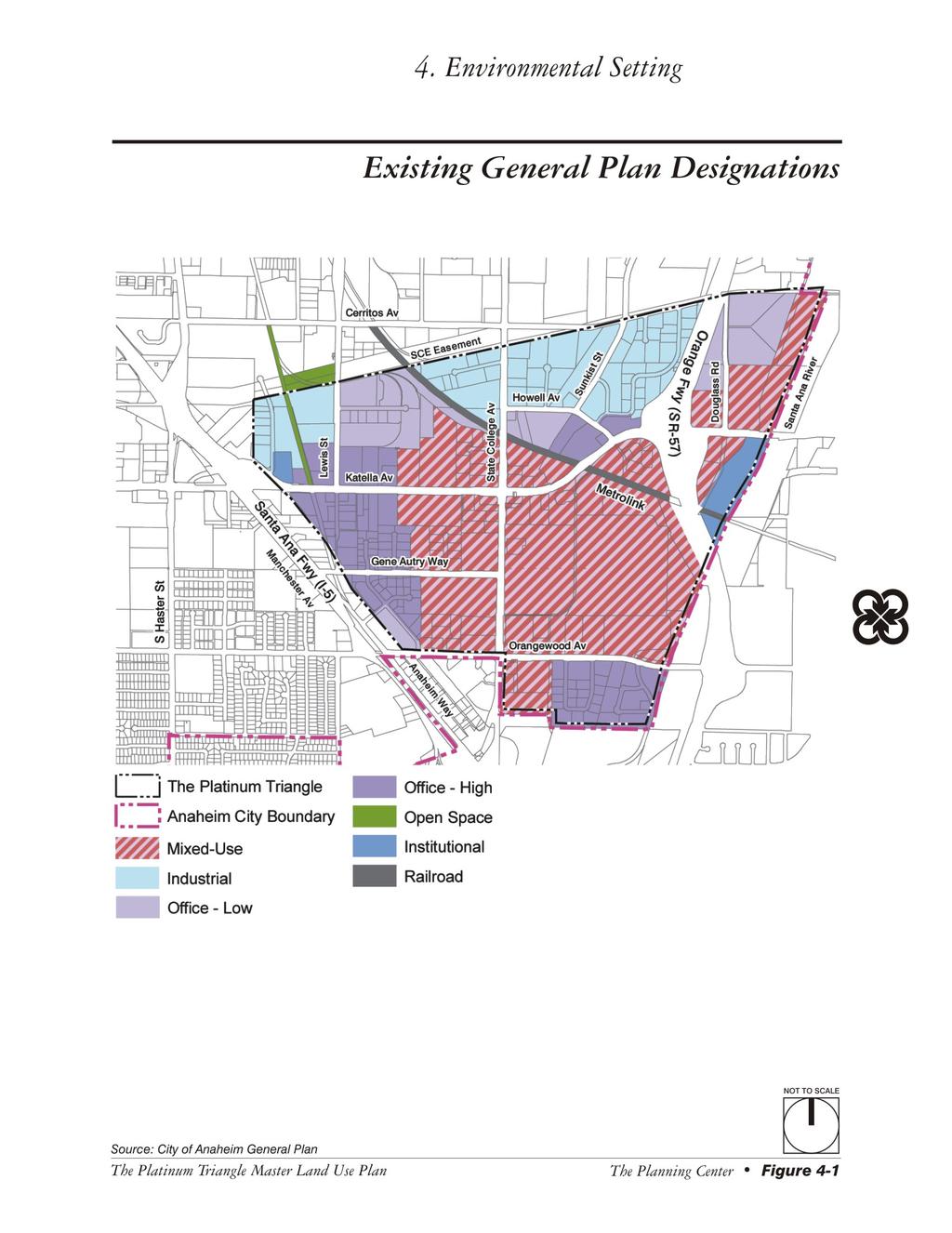
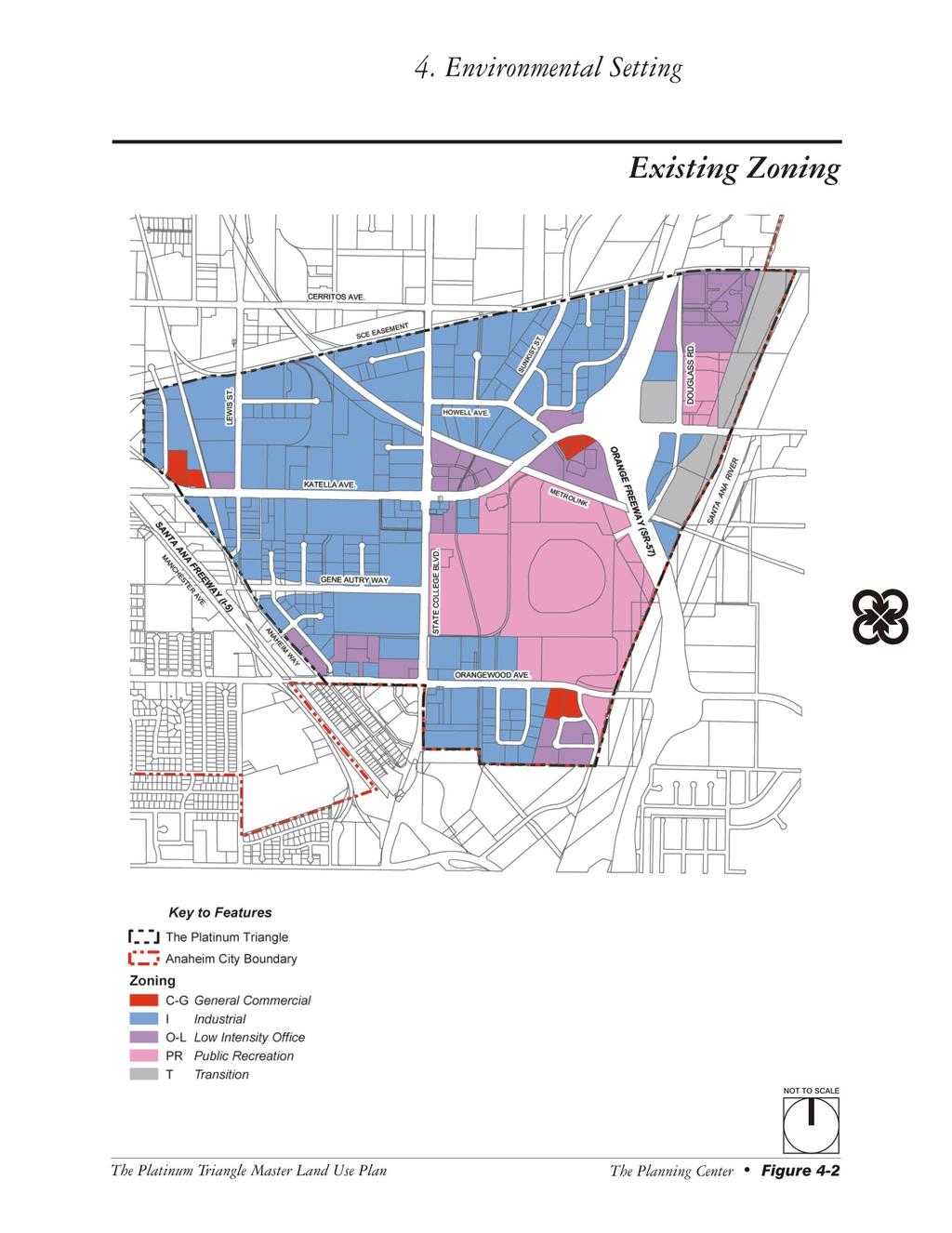
4 Utilities are currently provided to The Platinum Triangle by a number of utility providers. Electricity is provided by Anaheim Public Utilities Department (PUD), Electrical Services Division. Power supply comes primarily from PUD owned interest in the San Onofre Nuclear Power Plant and the Intermountain Power Project in Utah through PUD interstate and Southern California Edison (SCE) interstate high voltage transmission lines. Natural gas is provided by the Southern California Gas Company (SGC) which has gas lines along Orangewood Avenue, State College Boulevard, Katella Avenue, Gene Autry Way, and Lewis Street. Telephone and cable TV service is provided by Verizon and Adelphia. Water service is provided by the City of Anaheim Public Utilities Department, Water Division. Reserve supply will be purchased from the Metropolitan Water District (MWD). Wastewater and sewer services are provided by the City of Anaheim's local sanitary sewer system, and is a tributary to the County Sanitation District of Orange County (CSDOC). Solid waste pickup is provided by Anaheim Disposal Inc., under contract to the City of Anaheim Department of Public Works to provide waste hauling services throughout the City General Plan and Zoning The City of Anaheim General Plan designations for the site include Office-low, Office-High, Industrial, Institutional, Open Space and, Mixed-use, as shown on Figure 4-1, Existing General Plan Designations. These existing General Plan designations would allow for the development of a maximum of 9,175 dwelling units, 5,000,000 square feet of office uses, and approximately 2,000,000 square feet of commercial uses. Properties within the Project Area are zoned PR (Public Recreational), O-L (Low Intensity Office), OS (Open Space), SP (Semi-Public), T (Transitional), I (Industrial), and C-G (General Commercial), as shown on Figure 4-2, Existing Zoning. In addition, properties designated Mixed Use by the General Plan are within the PTMU (Platinum Triangle Mixed Use) Overlay Zone, which allows properties to be developed under the provisions of the underlying zone or the PTMU Overlay Zone. All of the properties designated Office-High by the General Plan have a resolution of intent to the O-H (High Intensity Office) Zone in addition to their existing zoning. Properties that are designated Office-Low by the General Plan and are not in the O-L Zone have resolutions of intent to the O-L Zone. The resolution of intent gives property owners the option of utilizing their existing zoning or finalizing to the O-L or O-H Zones as indicated above. Properties within the PTMU Overlay Zone or with a resolution of intent to the O-L or O-H Zones are shown on Figure 4-3, Additional Existing Zoning Provisions. Page 4-4 The Planning Center May 2005
5
6 This page intentionally left blank. Page 4-6 The Planning Center May 2005
7
8 This page intentionally left blank. Page 4-8 The Planning Center May 2005
9
10 This page intentionally left blank. Page 4-10 The Planning Center May 2005
11 4.4 ASSUMPTIONS REGARDING CUMULATIVE IMPACTS Section of the CEQA Guidelines states that cumulative impacts shall be discussed where they are significant. It further states that this discussion shall reflect the level and severity of the impact and the likelihood of occurrence, but not in as great a level of detail as that necessary for the project alone. Section of the Guidelines defines cumulative impacts to be two or more individual effects which, when considered together, are considerable or which compound or increase other environmental impacts. Cumulative impacts represent the change caused by the incremental impact of a project when added to other proposed or committed projects in the vicinity. The CEQA Guidelines (Section (b)(1) state that the information utilized in an analysis of cumulative impacts should come from one of two sources, either: 1. A list of past, present and probable future projects producing related cumulative impacts, including, if necessary, those projects outside the control of the agency; or 2. A summary of projections contained in an adopted general plan or related planning document designed to evaluate regional or area-wide conditions. The cumulative impact analysis contained in this DSEIR uses method 2, as described above. The City of Anaheim recently completed a comprehensive General Plan and Zoning Code Update, which was adopted by the Anaheim City Council on May 25, The adopted General Plan designates the general distribution of land uses and intensities throughout the City. As a result, the cumulative impact analysis contained in this DSEIR utilizes the projections contained in the City s adopted General Plan and associated Program EIR No The land use intensities allowed by the adopted General Plan are shown on Table 4-1. The Southern California Association of Governments (SCAG) has adopted growth forecasts for each Subregion within the SCAG region, including Los Angeles, Orange, San Bernardino, Riverside, Ventura, and Imperial Counties through the year The City of Anaheim is located in the Orange County Council of Governments Subregion. Therefore, the cumulative impact analysis for the General Plan Update utilized the regional growth projections contained in the Destination 2030 Final Draft 2004 Regional Transportation Plan, February 2004 for the Orange County Council of Governments Subregion. Because the update of the Anaheim General Plan and Zoning Code Update would guide future growth within the City and its Sphere of Influence as a whole, cumulative citywide impacts have been addressed in the context of overall growth projected for the region, which includes projects underway and planned in the City of Orange adjacent to The Platinum Triangle. The Proposed Project consists of implementation of The Platinum Triangle Master Land Use Plan and associated actions as indicated in Section 3.3.2, Description of the Project. The cumulative impacts of this project have been addressed for each environmental category discussed in Chapter 5.0, Environmental Analysis, of this DSEIR. The Platinum Triangle Subsequent EIR City of Anaheim Page 4-11
12 Table 4-1 General Plan Buildout Potential for Purposes of Cumulative Impact Analysis Existing Land Use Adopted General Plan Remaining Buildout Potential Single Family Dwelling Units 45,807 55,463 9,656 Multi Family Dwelling Units 55,979 73,697 17,718 Total Dwelling Units 101, ,159 27,373 Population 337, ,773 66,073 Commercial Square Footage 9,029,400 14,885,342 5,855,942 Office Square Footage 7,775,167 15,021,049 7,245,882 Industrial SF 44,467,380 30,614,730 13,852,650 Total SF 61,271,947 60,521, ,826 Commercial Employment 25,829 95,453 69,624 Office Employment 25,569 58,793 33,226 Industrial Employment 121,189 63,292 57,897 Other Employment 29,793 33,858 4,065 Total Employment 202, ,397 49,018 Notes: The figures contained herein are based on GIS mapping data prepared as part of the General Plan and Zoning Code Update existing dwelling unit data and nonresidential square footage provided by the City of Anaheim. Dwelling unit projections assumes split of single-family and multi-family dwelling units in the Low Medium Density, Hillside Low Medium Density, and Hillside Medium Density categories for the Existing General Plan population source: California Department of Finance (January 2002) Population projections assume average household size of 3.3 for non-mixed-use designations and 1.5 for mixed-use designation employment data provided by Parsons Brinckerhoff. Employment is based on existing square footage of employment generating land uses and traffic trips. Hotel rooms are included in the Commercial square footage. Open space acreage is not shown. Source: City of Anaheim General Plan and Zoning Code Update Final EIR No. 330, State Clearinghouse Number (May 2004; The Planning Center) Page 4-12 The Planning Center May 2005
3. Project Description
 3.1 PROJECT LOCATION The Platinum Triangle (herein after also referred to as the Project Area ) is located at the confluence of the Interstate 5 (I-5 Freeway) and the State Route 57 (SR-57 Freeway), in
2. INTRODUCTION 2.1 AUTHORITY 2.2 PURPOSE AND INTENT 2.3 SITE LOCATION
 2. INTRODUCTION 2.1 AUTHORITY The City of Gardena initiated and prepared the Artesia Corridor Specific Plan pursuant to the provisions of California Government Code, Title 7, Division 1, Chapter 3, Article
4. ENVIRONMENTAL IMPACT ANALYSIS 7. LAND USE AND PLANNING
 4. ENVIRONMENTAL IMPACT ANALYSIS 7. LAND USE AND PLANNING 4.7.1 INTRODUCTION The following analysis discusses the consistency of the Proposed Project with the corresponding land use and zoning designations
3.0 LAND USE PLAN. 3.1 Regional Location. 3.2 Existing Conditions Existing Uses. Exhibit Regional Location Map
 3.0 LAND USE PLAN 3.1 Regional Location The Anaheim Resort Specific Plan (ARSP) area is located in the City of Anaheim, which is 35 miles southeast of downtown Los Angeles and 7 miles northwest of Santa
Table of Contents G.1.a Water Resources - Surface Water - Drainage
 Table of Contents G.1.a Water Resources - Surface Water - Drainage 1. INTRODUCTION... 1335 2. ENVIRONMENTAL SETTING... 1335 a. Regional Hydrology... 1335 b. Local Hydrology... 1337 c. On-site Hydrology...
Venice Pumping Plant Dual Force Main Project Draft EIR
 City of Los Angeles 5.9 LAND USE PLANS 5.9.1 Environmental Setting Venice Pumping Plant Dual Force Main Project Draft EIR The Project lies within the bounds of Los Angeles County and the City of Los Angeles.
3.0 Project Description
 3.0 Project Description 3.0 PROJECT DESCRIPTION 3.1 PROJECT LOCATION AND SETTING PROJECT LOCATION The proposed Downtown Lancaster Specific Plan Project (project) is located in the City of Lancaster, California.
3.10 LAND USE SETTING PROJECT SITE EXISTING LAND USE DESIGNATIONS AND ZONING. General Plan Land Use Designations.
 This section of the Draft EIR addresses the existing land uses on and adjacent to the project site and discusses the potential impacts of the proposed project on existing land uses. Key issues addressed
2.0 THE PLATINUM TRIANGLE VISION
 2.0 THE PLATINUM TRIANGLE VISION The envisions an exciting future for the area surrounding Angel Stadium of Anaheim, the Honda Center and The Grove of Anaheim. 2.1 Planning Principles In order to further
5.9 LAND USE Existing Conditions Historic Land Use Trends Existing Land Use Distribution
 5.9 LAND USE This section describes the existing land use pattern and land use planning/regulatory framework in the City of Fontana. It also evaluates potential long-term land use impacts such as physically
Department of Community Development. Planning and Environmental Review Division Revised Notice of Preparation
 Department of Community Development Michael J. Penrose, Acting Director Divisions Building Permits & Inspection Code Enforcement County Engineering Economic Development & Marketing Planning & Environmental
IV.B. VISUAL RESOURCES
 IV.B. VISUAL RESOURCES ENVIRONMENTAL SETTING Existing Visual Character Project Site The project site is located at 17331-17333 Tramonto Drive in the Pacific Palisades community of the City of Los Angeles
CHAPTER 10 AESTHETICS
 CHAPTER 10 AESTHETICS CHAPTER 10 AESTHETICS This section identifies and evaluates key visual resources in the project area to determine the degree of visual impact that would be attributable to the project.
3.0 PROJECT DESCRIPTION
 3.0 PROJECT DESCRIPTION 3.1 BACKGROUND Under California law (Government Code Section 65300 et seq.), every city and county is required to have a general plan. The general plan is to be comprehensive and
5. Environmental Analysis
 5.1 This section of the Draft Environmental Impact Report (DEIR) describes the existing landform and aesthetic character of the project area and discusses the potential impacts to the visual character
HAZARD MITIGATION GOALS AND OBJECTIVES
 SEWRPC Community Assistance Planning Report No. 282, 2nd Edition CITY OF MILWAUKEE ALL HAZARDS MITIGATION PLAN UPDATE Chapter IV HAZARD MITIGATION GOALS AND OBJECTIVES [NOTE: Throughout this plan update
ENVIRONMENTAL SETTING
 II. ENVIRONMENTAL SETTING EXISTING CONDITIONS The 208.87-acre Project site is located in the western portion of the City (refer to Figures II-1 and II-2). The Project site comprises Assessor s Parcel Number
PROJECT DESCRIPTION ENVIRONMENTAL SETTING. Project Site Location FIGURE 1 - REGIONAL LOCATION MAP
 PROJECT DESCRIPTION ENVIRONMENTAL SETTING Project Site Location The proposed project site is located within the City of Camarillo in Ventura County. As shown in Figure 1, the City of Camarillo is located
SAN RAFAEL GENERAL PLAN 2040 INTRODUCTION AND OVERVIEW
 SAN RAFAEL GENERAL PLAN 2040 INTRODUCTION AND OVERVIEW Steering Committee Presentation February 14, 2018 Purpose of General Plan Guide land use and development decisions Coordinate transportation, infrastructure,
SECTION 4.8 LAND USE DRAFT ENVIRONMENTAL IMPACT REPORT DEEP VALLEY DRIVE AND INDIAN PEAK ROAD MIXED-USE RESIDENTIAL PROJECT
 LSA ASSOCIATES, INC. J UNE 2012 SECTION 4.8 LAND USE 4.8 LAND USE Introduction Comprising 10.4 acres (ac), the proposed project site is located in the City of Rolling Hills Estates (City) between Deep
Nob Hill Pipeline Improvements Project EIR
 Section 3.1 Aesthetics This section addresses the visual aspects that may affect the views experienced by the public, including the potential to impact the existing character of each area that comprises
City of Orange Trails at Santiago Creek Specific Plan Recirculated Draft EIR Appendix C: Notice of Preparation (NOP) and Comment Letters
 and Comment Letters") City of Orange Trails at Santiago Creek Specific Plan Recirculated Draft EIR Appendix C: Notice of Preparation (NOP) and Comment Letters FirstCarbon Solutions Y:\Publications\Client (PN-JN)\2765\27650002\EIR\10
City of Orange Trails at Santiago Creek Specific Plan Recirculated Draft EIR Appendix C: Notice of Preparation (NOP) and Comment Letters FirstCarbon Solutions Y:\Publications\Client (PN-JN)\2765\27650002\EIR\10
When planning stormwater management facilities, the following principles shall be applied where possible.
 2.0 Principles When planning stormwater management facilities, the following principles shall be applied where possible. 2.0.1 Drainage is a regional phenomenon that does not respect the boundaries between
CITY OF CYPRESS 5275 Orange Avenue Cypress, California (714) DESIGN REVIEW COMMITTEE PERMIT PROCESS
 DESIGN REVIEW COMMITTEE PERMIT PROCESS") CITY OF CYPRESS 5275 Orange Avenue Cypress, California 90630 (714) 229-6720 DESIGN REVIEW COMMITTEE PERMIT PROCESS 1. Discuss project with Planning staff to determine zoning regulations, any unusual characteristics
CITY OF CYPRESS 5275 Orange Avenue Cypress, California 90630 (714) 229-6720 DESIGN REVIEW COMMITTEE PERMIT PROCESS 1. Discuss project with Planning staff to determine zoning regulations, any unusual characteristics
1 INTRODUCTION. A. Purpose of this General Plan
 1 How will Chino become a healthier place to live, work, and play? The City has established community health as a focus of this General Plan. Health touches all aspects of a community, from where residents
Notice of Preparation of an Environmental Impact Report and Scoping Meeting for the Canyon Lane Roadway Improvements Development Project
 of an Environmental Impact Report and Scoping Meeting for the As the Lead Agency, the County of San Mateo (County) will prepare an Environmental Impact Report (EIR) for the (project), and would like your
CHAPTER 1. Ms. Guajardo s Class - Central Elementary CH 1 1
 INTRODUCTION CHAPTER 1 Ms. Guajardo s Class - Central Elementary CH 1 1 1.1 SETTING South Centre City is a linear corridor south of Downtown Escondido paralleling Centre City Parkway and South Escondido
Drexel, Barrell & Co.
 Drexel, Barrell & Co. June 18, 2018 Engineers/Surveyors Boulder Colorado Springs Greeley 3 South 7 th Street Colorado Springs, Colorado 80905-1501 719 260-0887 719 260-8352 Fax El Paso County Planning
III. ENVIRONMENTAL SETTING
 III. ENVIRONMENTAL SETTING A. OVERVIEW OF ENVIRONMENTAL SETTING Regional Setting The project site is located in Los Angeles County in the northeastern San Fernando Valley, approximately 18 miles north
SOUTH NATOMAS COMMUNITY PLAN
 SOUTH NATOMAS Community Plan Part Three : COMMUNITY PLAN AREAS AND SPECIAL STUDY AREAS SACRAMENTO 2030 GENERAL PLAN Contents Community Location... 3-SN-3 Community Vision... 3-SN-4 Community Profile...
A. OVERVIEW OF ENVIRONMENTAL SETTING
 IV. A. OVERVIEW OF The proposed site is comprised of three parcels totaling approximately 4.24 acres, situated southwesterly of the intersection of Weyburn and Tiverton Avenues. Parcel A is 2.72 acres
IV. ENVIRONMENTAL IMPACT ANALYSIS H. LAND USE AND PLANNING
 IV. ENVIRONMENTAL IMPACT ANALYSIS H. LAND USE AND PLANNING ENVIRONMENTAL SETTING The Project Site is located in Los Angeles County, within the Hollywood Community Plan area of the City of Los Angeles.
Definitions. Average Daily Traffic Demand (ADT): The actual number or projected number of cars that pass a point in a 24-hour period.
: The actual number or projected number of cars that pass a point in a 24-hour period.") Definitions Access Management: A combination of physical techniques and transportation policies used to control the flow of traffic between roads and the surrounding lands. Alternative City Form Scenarios:
Definitions Access Management: A combination of physical techniques and transportation policies used to control the flow of traffic between roads and the surrounding lands. Alternative City Form Scenarios:
NOTICE OF PREPARATION
 NOTICE OF PREPARATION DATE: April 6, 2017 TO: FROM: Responsible Agencies Trustee Agencies Local and Public Agencies Interested Parties Contact: Brent Cooper, AICP, Community Development Director 4381 Broadway
Section 2 Study Area
 Study Area Section 2 Study Area 2-1 Purpose This section describes the study area of the Update and discusses the existing and future land uses within the study area. 2-2 Location The study area, as shown
Section 4.11 Traffic and Transportation 4.11 TRAFFIC AND TRANSPORTATION
 4.11 TRAFFIC AND TRANSPORTATION The following sections summarize the evaluation of the potential traffic/transportation impacts of the San Gabriel River Corridor Master Plan. First, the analysis methodology
open public hearing and allow public comment request to continue LPA public hearing to January 16, 2014 at 10:30 am
 TODAY S AGENDA Work Session LPA Transmittal Public Hearing open public hearing and allow public comment request to continue LPA public hearing to January 16, 2014 at 10:30 am staff will issue a recommendation
4.0 AFFECTED ENVIRONMENT AND ENVIRONMENTAL CONSEQUENCES
 4.0 AFFECTED ENVIRONMENT AND ENVIRONMENTAL CONSEQUENCES The following sections discuss the impacts associated with environmental resources for the tunneling method Alternatives A and B. The construction
CITY OFLOS ANGELES CALIFORNIA
 BOARD OF PUBLIC WORKS MEMBERS KEVIN JAMES PRESIDENT HEATHER MARIE REPENNING VICE PRESIDENT MICHAEL R. DAVIS PRESIDENT PRO TEMPORE JOEL F. JACINTO COMMISSIONER VACANT COMMISSIONER FERNANDO CAMPOS EXECUTIVE
5.11 AESTHETICS ENVIRONMENTAL SETTING
 5.11 AESTHETICS ENVIRONMENTAL SETTING The lies on a relatively flat valley floor surrounded by rugged hills and mountains. The topography of the planning area is defined by the Box Springs Mountains and
IV. ENVIRONMENTAL IMPACT ANALYSIS B. AESTHETICS 1. VIEWS
 IV. ENVIRONMENTAL IMPACT ANALYSIS B. AESTHETICS 1. VIEWS ENVIRONMENTAL SETTING Existing Visual Character Project Site The project site is located at 10250 Wilshire Boulevard in the Westwood community of
CITY OF TIGARD EXPECTED SERVICE AREA
 CITY OF TIGARD EXPECTED SERVICE AREA City overview / Background Incorporated in 1961, the has experienced rapid growth over the years. This growth can be attributed to many factors, primarily the close
SECTION 3.0 Project Description
 SECTION 3.0 3.0 PROJECT DESCRIPTION 3.1 PROJECT LOCATION AND SETTING PROJECT LOCATION The proposed Perris Downtown Specific Plan (DTSP) project (project) is located in the City of Perris, California. The
Whittier Greenway Trail. Est. 2009
 Whittier Greenway Trail Est. 2009 The Whittier Greenway Trail begins in the northwest corner of Whittier, near the 605 Freeway, and closely parallels Whittier Boulevard. When it reaches Painter Avenue,
IV. ENVIRONMENTAL IMPACT ANALYSIS I. LAND USE PLANNING
 IV. ENVIRONMENTAL IMPACT ANALYSIS I. LAND USE PLANNING ENVIRONMENTAL SETTING Existing Onsite Land Uses The 3.8-acre project site is located at 2055 Avenue of the Stars in the West Los Angeles community
Notice of Preparation and Notice of Public Scoping Meeting. At Dublin Project
 Notice of Preparation and Notice of Public Scoping Meeting Date January 17, 2018 To Project Title Project Application Number Project Location Project Applicant Contact For questions or submitting comments.
A. WHAT IS A GENERAL PLAN?
 I. Introduction A. WHAT IS A GENERAL PLAN? A general plan is the planning guideline for the future of a city. It contains goals and policies which regulate urban development, the protection of the natural
III. GENERAL DESCRIPTION OF ENVIRONMENTAL SETTING
 III. GENERAL DESCRIPTION OF ENVIRONMENTAL SETTING Section 15125 of the California Environmental Quality Act (CEQA) Guidelines requires that an EIR include a description of the existing environment. This
COASTAL CONSERVANCY. Staff Recommendation March 25, 2004 LOS ANGELES GREEN VISION PLAN. File No.: Project Manager: Marc Beyeler
 COASTAL CONSERVANCY Staff Recommendation March 25, 2004 File No.: 04-014 Project Manager: Marc Beyeler RECOMMENDED ACTION: Authorization to disburse up to $50,000 to the University of Southern California
Leduc Industrial Outline Plan SE W4
 Leduc Industrial Outline Plan SE 1-50-25-W4 Within the North Leduc Industrial ASP Prepared for: Leduc Energy Park Ltd. Prepared by: Stantec Consulting Ltd. File No. 1161 104655 V5 Table of Contents 1.0
Environmental Setting, Impacts, and Mitigation Measures
 CHAPTER 3 Environmental Setting, Impacts, and Mitigation Measures Format of the Environmental Analysis The assessment of each environmental resource discussed in this chapter includes the following: Environmental
THEMES, VISION, + PRINCIPLES
 CHAPTER 2: THEMES, VISION, + PRINCIPLES This page intentionally left blank. 20 VISION DRAFT AUGUST 2018 2 2 THEMES, VISION, + GUIDING PRINCIPLES The Key Themes, Vision, and Guiding Principles presented
5.1 LAND USE AND RELEVANT PLANNING
 5.1 LAND USE AND RELEVANT PLANNING The purpose of this section is to identify the existing land use conditions, evaluate consistency with relevant planning policies and recommend mitigation measures, which
3.5 - Land Use and Planning
 City of Irvine - William Lyon Homes: Vista Verde Land Use and Planning 3.5 - Land Use and Planning 3.5.1 - Introduction This section describes existing land uses, applicable land use plans, policies or
Chesapeake Bay Critical Area Conservation Plan
 The Maryland-National Capital Park and Planning Commission Prince George s County Planning Department Development Review Division 301-952-3530 Note: Staff reports can be accessed at www.mncppc.org/pgco/planning/plan.htm.
4.1 AESTHETICS EXISTING ENVIRONMENTAL SETTING ALAMITOS BAY MARINA REHABILITATION PROJECT CITY OF LONG BEACH
 4.1 AESTHETICS This section provides a discussion of the existing visual and aesthetic resources on site and in the surrounding area as well as an analysis of potential impacts from implementation of the
SECTION I: VISION. The Preserve Specific Plan
 SECTION I: VISION 1 This page intentionally left blank. VISION Section I The following is the vision for The Preserve adopted by the Chino City Council. A special environment has taken shape where once
II. SUMMARY WEBB A. PROJECT SUMMARY 1. PROJECT LOCATION
 Section II Summary II. SUMMARY A. PROJECT SUMMARY 1. PROJECT LOCATION The MAJESTIC FREEWAY BUSINESS CENTER SPECIFIC PLAN (SP 341) project site is located on approximately 325 gross acres, within the Mead
Chapter 12. Land Use
 \ I Chapter 12 Chapter 12. INTRODUCTION This chapter describes existing and planned land uses in the JOS service area and identifies impacts of the JOS 2010 Master Facilities Plan and alternatives. Existing
2.0 PROJECT DESCRIPTION
 2.0 PROJECT DESCRIPTION 2.1 PROJECT LOCATION The Project Site is located in the City of Santa Clarita, California, about 35 miles north of Downtown Los Angeles. The Project Site is more specifically located
SECTION 5.1 Aesthetics, Light, and Glare
 SECTION 5.1 Aesthetics, Light, and Glare 5.1 AESTHETICS, LIGHT, AND GLARE Visual resources information for this section was compiled from photographs and site surveys conducted by RBF Consulting. The purpose
ENVIRONMENTAL IMPACT REPORT COMPREHENSIVE GENERAL PLAN AND ZONING ORDINANCE SCH NUMBER:
 ENVIRONMENTAL IMPACT REPORT FOR THE CITY OF BANNING COMPREHENSIVE GENERAL PLAN AND ZONING ORDINANCE SCH NUMBER: 2005011039 Prepared for: City of Banning 99 East Ramsey Street Banning, CA 92220 Prepared
1.1 EXECUTIVE SUMMARY
 SECTION 1 INTRODUCTION 1.1 EXECUTIVE SUMMARY The La Entrada Specific Plan is a comprehensive amendment to, and expansion of, the approved McNaughton Plan, located in the City of Coachella, within the Coachella
The impacts examined herein take into account two attributes of aesthetic values:
 IV. ENVIRONMENTAL IMPACT ANALYSIS This section addresses the potential impacts to views and aesthetics as a result of the proposed Project at the Project Site and the development scenarios analyzed for
Drexel, Barrell & Co.
 Drexel, Barrell & Co. December 21, 2018 Engineers/Surveyors Boulder Colorado Springs Greeley 3 South 7 th Street Colorado Springs, Colorado 80905-1501 719 260-0887 719 260-8352 Fax El Paso County Planning
Existing Transportation System 5-1
 5-1 The Jackson County transportation system is served by several modes of transportation including streets and highways, multi-modal, non-motorized, rail, and aviation. While the focus of the transportation
Appendix A: Notice of Preparation and Responses
 City of American Canyon Broadway District Specific Plan Draft EIR Appendix A: Notice of Preparation and Responses FirstCarbon Solutions \\10.200.1.5\adec\Publications\Client (PN JN)\3148\31480009\EIR\2
Riverside County Flood Control and Water Conservation District LAKELAND VILLAGE MDP LINE H, STAGE 1
 Riverside Flood Control and Water Conservation District Riverside, California LAKELAND VILLAGE MDP LINE H, STAGE 1 CEQA ADDENDUM TO THE FINAL PROGRAM ENVIRONMENTAL IMPACT REPORT FOR THE LAKELAND VILLAGE
SANTA BARBARA COUNTY ZONING ADMINISTRATOR STAFF REPORT February 5, 2016
 SANTA BARBARA COUNTY ZONING ADMINISTRATOR STAFF REPORT February 5, 2016 PROJECT NAME: Public Works Isla Vista Sidewalk Improvements & Tree Replacement HEARING DATE: February 22, 2016 STAFF / PHONE: J.
2.0 PROJECT DESCRIPTION
 2.0 PROJECT DESCRIPTION The proposed project involves the redevelopment of an approximately 6.3-acre site in the City of Long Beach with a mixed-use village center project. This section describes the project
NOTICE OF PREPARATION
 NOTICE OF PREPARATION DATE: January 6, 2016 TO: LEAD AGENCY: Responsible Agencies, Organizations, and Interested Parties Contact: Tyler Barrington, Principal Planner Planning Department Community Development
SUSSEX COUNTY COMPREHENSIVE PLAN COUNTY PLANNING AND ZONING COMMISSION WORKSHOP
 SUSSEX COUNTY COMPREHENSIVE PLAN COUNTY PLANNING AND ZONING COMMISSION WORKSHOP August 21, 2017 TODAY S WORKSHOP Public Comment Utilities Update Economic Development Update Future Land Use Discussion Public
CITY OF SEASIDE STAFF REPORT
 Item 12 CITY OF SEASIDE STAFF REPORT TO: FROM: BY: Honorable Mayor and City Council Ray Corpuz, City Manager Diana Ingersoll, Deputy City Manager, Resource Management Services Rick Medina, Senior Planner
SECTION IV: DEVELOPMENT CONCEPT
 80 SECTION IV: DEVELOPMENT CONCEPT Section IV: DEVELOPMENT CONEPT This section provides an overall understanding and rationale for what is envisioned in The Preserve, the intended quality and character
Planning Commission Report
 Planning Commission Report To: From: Subject: Planning Commission Meeting: January 6, 2016 Agenda Item: 8-B Planning Commission David Martin, Planning & Community Development Director Introduction to the
IV. ENVIRONMENTAL IMPACT ANALYSIS I. LAND USE AND PLANNING
 IV. ENVIRONMENTAL IMPACT ANALYSIS I. LAND USE AND PLANNING ENVIRONMENTAL SETTING The Project Site is located on an irregularly shaped 58 gross square acre property currently occupied by the Verdugo Hills
Section Regulatory Framework/Methodology. Land Use and Development
 Section 4.2 Land Use and Development This section summarizes the existing land uses and developments in the project area, and the potential impacts of the proposed alternatives on these resources. Information
COMMUNITY DEVELOPMENT SERVICES PLANNING AND BUILDING DEPARTMENT PLACERVILLE OFFICE:
 COMMUNITY DEVELOPMENT SERVICES PLANNING AND BUILDING DEPARTMENT http://www.edcgov.us/devservices/ PLACERVILLE OFFICE: LAKE TAHOE OFFICE: 2850 Fair Lane Court, Placerville, CA 95667 924 B Emerald Bay Rd.
4.8 Landform Alteration and Aesthetics
 4.8 Landform Alteration and Aesthetics 4.8 LANDFORM ALTERATION AND AESTHETICS This section describes the potential environmental effects related to temporary and permanent impacts to landform and aesthetics,
Authority of the General Plan
 Authority of the General Plan This La Habra Heights General Plan will serve as the blueprint for future planning and development in the City. This General Plan describes the City s vision for the future
SOUTHEAST AREA SPECIFIC PLAN. Planning Commission Study Session August 18, 2016
 SOUTHEAST AREA SPECIFIC PLAN Planning Commission Study Session August 18, 2016 Background: How did we get here? Directed by City Council to prepare Specific Plan (2012) Sustainability focused grant from
Staff Report and Recommendation
 Community Planning and Development Planning Services 201 W. Colfax Ave., Dept. 205 Denver, CO 80202 p: 720.865.2915 f: 720.865.3052 www.denvergov.org/cpd TO: City Council Neighborhoods and Planning Committee
CHAPTER 2 SUMMARY 1. PROJECT SUMMARY DATA
 CHAPTER 2 SUMMARY This is an Initial Study format used to determine, pursuant to CEQA Guidelines Section 15177, whether a project 1) is within the scope of a Master EIR (MEIR), 2) may result in additional
AWH REPORT OF THE PLANNING AND DEVELOPMENT DEPARTMENT FOR APPLICATION FOR REZONING ORDINANCE TO PLANNED UNIT DEVELOPMENT
 AWH REPORT OF THE PLANNING AND DEVELOPMENT DEPARTMENT FOR APPLICATION FOR REZONING ORDINANCE TO PLANNED UNIT DEVELOPMENT MAY 8, 2014 The Planning and Development Department hereby forwards to the Planning
SECTION 3 PROJECT DESCRIPTION
 SECTION 3 PROJECT DESCRIPTION 3.1 PROJECT LOCATION The Preserve planning area is located in the extreme southwestern corner of San Bernardino County, approximately 37 miles east of Los Angeles and 20 miles
NOTICE OF PREPARATION
 Date: June 30, 2017 CITY OF CITRUS HEIGHTS COMMUNITY & ECONOMIC DEVELOPMENT DEPARTMENT, PLANNING DIVISION 6360 Fountain Square Drive, Citrus Heights, CA 95621 (916) 727-4740 NOTICE OF PREPARATION To: Subject:
Route 66 Business Corridor
 Route 66 Business Corridor DOWNTOWN BUSINESS AND CULTURAL DISTRICT SPECIFIC PLAN Draft April 2016 Acknowledgments Text Acknowledgments here etc... LIST NAME List List List Table of Contents 1. Introduction...
Cornwall Park Neighborhood Plan
 [1] Cornwall Park Neighborhood Plan As adopted by Ordinance No. 8868 and amended by Ordinance Nos. 8946, 9200, 9201, 9233, 9301, 9305, 9749, 9787, 9764, 10502 and 10738, 2000-12-094, 2004-12-087, 2004-12-091,
Draft Gaviota Coast Plan Chapter 7: Visual Resources
 Draft Gaviota Coast Plan Chapter 7: Visual Resources 11/28/2012 Long Range Planning Division Planning and Development Department County of Santa Barbara Page Intentionally Blank Cover Photo: Gaviota Morning
6.8 SCENIC HIGHWAYS Introduction
 6.8 SCENIC HIGHWAYS 6.8.1 Introduction The Scenic Highways Element is an optional General Plan element authorized by Section 65303 of the Government Code. The Scenic Highways Element is intended to establish
2.1.8 Cultural Resources Regulatory Setting. Affected Environment, Environmental
 REVISED DRAFT ENVIRONMENTAL IMPACT REPORT/ Affected Environment, Environmental 2.1.8 Cultural Resources This section evaluates the potential for historical and archaeological resources within the proposed
TRANSPORTATION ELEMENT GOALS, OBJECTIVES, AND POLICIES
 TRANSPORTATION ELEMENT GOALS, OBJECTIVES, AND POLICIES GOAL 2 The City shall provide a safe, convenient, effective, and energy efficient multimodal transportation system which is coordinated with the Future
COUNTY OF RIVERSIDE PLANNING DEPARTMENT STAFF REPORT
 Agenda Item No.: 5.4 Area Map: Jurupa Zoning District: Prado-Mira Loma Supervisorial District: Second Project Planner: Christian Hinojosa Planning Commission: February 3, 2010 Conditional Use Permit No.
4. SPECIFIC PLAN CONCEPTS
 4. SPECIFIC PLAN CONCEPTS 4.1 SPECIFIC PLAN OBJECTIVES The overall purpose of this Specific Plan is to generate momentum and provide comprehensive direction for the improvement of the Artesia Corridor
APPENDIX D: BACKGROUND AND VISION
 APPENDIX D: BACKGROUND AND VISION BACKGROUND A. Specific Plan Location Jordan Downs is located at 9800 Grape Street in Los Angeles, California, 90002. The Jordan Downs Urban Village Specific Plan area
PLANNING COMMISSION. Submitted
 PLANNING COMMISSION City Hall 1275 Main Street El Centro, CA 92243 Submitted PLANNING COMMISSION ACTION ITEM (1844) Meeting: 05/10/16 12:00 AM Department: Community Development Category: Public Hearing
ADOPTED CAPITAL IMPROVEMENT PROGRAM BUDGET ARROYO PROJECTS
 ADOPTED CAPITAL IMPROVEMENT PROGRAM BUDGET ARROYO PROJECTS HAHAMONGNA FY 212-216 Capital Improvement Program Priority Description Total Estimated Costs Appropriated Through FY 211 Adopted FY 212 FY 213
City Center Specific Plan Amendments And Background Report City of Richmond. PLANNING COMMISION FINAL DRAFT January, 2001
 City Center Specific Plan Amendments And Background Report City of Richmond PLANNING COMMISION FINAL DRAFT January, 2001 TABLE OF CONTENTS Page LIST OF TABLES... LIST OF FIGURES... INDEX... OVERVIEW...
Glenn Highway MP DSR. Landscape Narrative
 Glenn Highway MP 34-42 DSR Landscape Narrative Project Landscape Goals The Glenn Highway MP 34-42 Project extends through a variety of landscape types typical to the Matanuska-Susitna Valley. In general,
Improve Neighborhood Design and Reduce Non Point Source Water Pollution
 HOW TO Planning Guide Improve Neighborhood Design and Reduce Non Point Source Water Pollution This document was funded by a grant from the New Hampshire Coastal Program with funding from the National Oceanic