Authority: Toronto and East York Community Council Item 26.14, as adopted by City of Toronto Council on October 8, 9, 10 and 11, 2013 CITY OF TORONTO
|
|
|
- Jayson Dawson
- 6 years ago
- Views:
Transcription
1 Authority: Toronto and East York Community Council Item 26.14, as adopted by City of Toronto Council on October 8, 9, 10 and 11, 2013 CITY OF TORONTO BY-LAW No To adopt Amendment No. 183 to the Official Plan of the City of Toronto respecting the North Downtown Yonge Site and Area Specific Policy Area generally between the north side of College/Carlton Streets, the south side of Charles Street, the west side of Bay Street and the east side of Church Street. Whereas authority is given to Council under the Planning Act, R.S.O. 1990, c.p. 13, as amended, to pass this By-law; and Whereas the Council for the City of Toronto, at its meeting on October 8, 9, 10 and 11, 2013, determined to amend the Official Plan for the City of Toronto adopted by By-law No ; and Whereas the Council of the City of Toronto has provided adequate information to the public and has held at least one public meeting in accordance with the Planning Act; The Council of the City of Toronto enacts: 1. The attached Amendment No. 183 to the City of Toronto Official Plan is adopted pursuant to the Planning Act, R.S.O. 1990, c.p. 13, as amended. 2. This is Official Plan Amendment No Enacted and passed on November 15, Frances Nunziata, Speaker Ulli S. Watkiss, City Clerk (Seal of the City)
2 2 AMENDMENT NO. 183 TO THE OFFICIAL PLAN North Downtown Yonge Site and Area Specific Policy SCHEDULE "A" The Official Plan of the City of Toronto is amended as follows: 1. Chapter 7, Site and Area Specific Policies, is amended by deleting Site and Area Specific Policy 155 and by adding the following Site and Area Specific Policy 382: "382. North Downtown Yonge Site and Area Specific Policy, located generally between the south side of College/Carlton Streets, the south side of Charles Street, the west side of Bay Street and the east side of Church Street: North Downtown Yonge Site and Area Specific Policy The lands shown on the above plan, which for reference are also shown on Map 1 - Character Areas and on Map 2 - Open Space Network and Height Areas, each found at the end of this Site and Area Specific Policy, are subject to the following policies: 1. GOALS This North Downtown Yonge Site and Area Specific Policy is intended to guide and shape development/redevelopment and private and public investment within the North Downtown Yonge Area by:
3 3 1.1 Identifying suitable levels of growth for each of the special Character Areas that form part of the overall area. 1.2 Establishing compatible development/redevelopment and built form policies for these sub-areas and, where appropriate, for the area as a whole. 1.3 Providing direction for parks, open space, private and public realm investment opportunities and priorities for the area. 1.4 Reinforcing the importance and value of protecting and enhancing the heritage context within which this area is situated. 1.5 Creating a sense of place for the North Downtown Yonge Area by having policies in place which help to identify the area as a unique and evolving mixed use community that accommodates both local level and non-local (regional and international) needs. 2. OBJECTIVES 2.1 Provide policies which reinforce the importance of Yonge Street as Toronto's iconic main street and accommodate development/redevelopment where appropriate. 2.2 Identify areas with growth potential and areas of limited growth, providing appropriate transitions in scale down to lower-scaled Character Areas, heritage properties, and parks and open space. 2.3 Enhance and improve the connectivity between the Character Areas and the streets and corridors located within the North Downtown Yonge Area, including Bay Street, Yonge Street, Church Street, Wellesley Street, and College and Carlton Streets. 2.4 Conserve and maintain the integrity of the cultural heritage values, attributes, character and three-dimensional form of heritage properties and the strong heritage fabric throughout this area and with particular reference to the Yonge Street, St. Nicholas, Dundonald/Gloucester and Church Street Village Character Areas. 2.5 Identify "priority" retail streets within the area and line these streets with active, graderelated uses which promote a safe and animated pedestrian environment. 2.6 Utilize, where appropriate, a narrow rhythm of multiple retail frontages along these retail streets that have been architecturally articulated through materials, numerous entrances, display windows, continuous canopies and signage. 2.7 Respect and complement the scale, character, form and setting of heritage properties along the street, including the historic streetwall scale of Yonge Street. 2.8 Maintain the existing mix of housing types and tenures to provide for a full range of housing opportunities within the area, including family sized units and encourage the provision of a full range of housing types and tenure when development/redevelopment occurs.
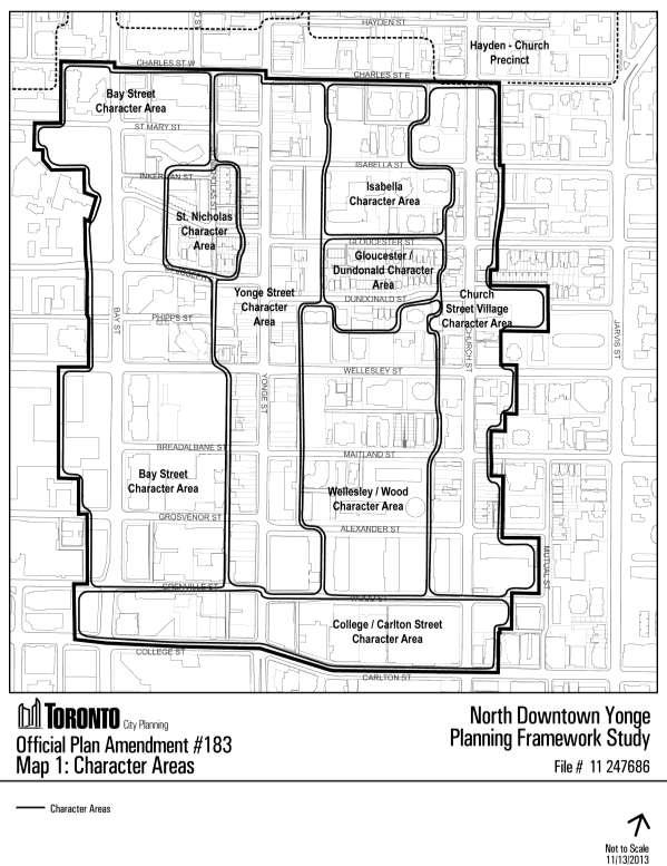
4 4 2.9 Expand and improve existing parks and the open space network and create new parks and open space connections as opportunities arise through development/redevelopment Protect access to sunlight and sky view within the surrounding context of streets, parks, public and private open space Require public realm improvements as part of development/redevelopment, including opportunities for expanded sidewalk widths, mid-block access, well designed promenades, gateways, and public transit access points Encourage design excellence and high quality architectural design through the effective use of resources, high-quality materials, innovative, sustainable and universally accessible building design for development/redevelopment, public realm improvements and parks and open space design Reinforce and support transit use throughout the North Downtown Yonge Area. 3. LAND USE POLICIES Development/redevelopment in the North Downtown Yonge Area will conform with the policies of the Official Plan and in particular the Neighbourhoods and Apartment Neighbourhoods land use policies, which limit growth in stable residential areas but provide for growth opportunities in areas designated as Mixed Use Areas. These and other Official Plan policies dealing with shaping Toronto and building a successful city will continue to apply, with some of these policies being further modified and enriched by this North Downtown Yonge Site and Area Specific Policy to address local context goals and objectives. Development/redevelopment policies have been addressed in two ways in this North Downtown Yonge Site and Area Specific Policy. Firstly, specific policies have been developed for individual sub-areas within the North Downtown Yonge Area identified as Character Areas. Secondly, policies have been identified that apply to the North Downtown Yonge Area as a whole. 4. DEVELOPMENT POLICIES A. Character Area Policies The Character Areas, as set out below, each have particular land use functions and building typologies representing diverse scales and heights. They consist of the following Character Areas, which have also been identified in Map 1, Character Areas, found at the end of these policies: Bay Street Character Area Yonge Street Character Area Gloucester/Dundonald Character Area College/Carlton Street Character Area St. Nicholas Character Area Isabella Character Area Wellesley Wood Character Area Church Street Village Character Area
5 5 Development/redevelopment will respond to these functions and characters, with built form and public realm solutions appropriate within the given Character Area as more fully described in Section 5 and as shown on Map 2, Open Space Network and Height Areas, found at the end of these policies. B. Area Wide Policies Policies relating to heritage, views, built form, parks and open space, and the public realm as they apply to individual or all the Character Areas, are found in Section 6 of this North Downtown Yonge Site and Area Specific Policy. C. Urban Design Guidelines Development/redevelopment and public realm improvements within the Character Areas, and the Area Wide Policies as noted in Section 6, will be further informed by: a) the North Downtown Yonge Urban Design Guidelines adopted by Council in July of 2013 and as further revised in September 2013, and such further revisions as Council may adopt from time to time; b) the city-wide Tall Buildings Design Guidelines and Downtown Tall Building Vision and Supplementary Design Guidelines, adopted by Council in May of 2013, and such further revisions as Council may adopt from time to time; c) the Bloor Yorkville/North Midtown Urban Design Guidelines, adopted by Council in June of 2004, as may be revised by Council from time to time for development/redevelopment on lands fronting onto the south side of Charles Street East, generally located one block west of Bay Street to one block east of Church Street, and including the Bay Street and Isabella Character Areas; and d) other applicable policies and guidelines adopted by Council that may apply, including such further revisions thereto as Council may adopt from time to time. 5. CHARACTER AREA POLICIES 5.1 Bay Street Character Area The Bay Street Character Area is a mature and largely built out area defined by a mix of uses including residential, office, institutional and commercial. Bay Street functions as an important spine through the city's downtown area transitioning between different uses and building heights and scale, and as a multi-modal transportation corridor. Growth is anticipated within the Bay Street Character Area in areas designated as Mixed Use Areas, save and except for the sub-area within the Bay Street Character Area designated as Apartment Neighbourhoods in the Official Plan. The Apartment Neighbourhoods area within the Bay Street Character Area is considered to be a stable area with limited lowrise infill potential.
6 Policies: 6 The area on the west side of Bay Street designated as an Institutional area in the Official Plan will continue to be guided by the University of Toronto Secondary Plan. Best efforts will be made, however, to incorporate the public realm policies contained in this Official Plan amendment for those Institutional lands fronting onto Bay Street in order to establish a cohesive public realm plan along both sides of the Bay Street frontage Development/redevelopment within the Bay Street Character Area will be located and massed to minimize shadow impacts throughout the day on adjacent Apartment Neighbourhoods lands, during all seasons of the year Development/redevelopment in the Mixed Use Areas portions of the Bay Street Character Area will provide an appropriate transition in scale and height to lower-scaled development in the Apartment Neighbourhoods area located within the adjacent St. Nicholas Character Area The only development/redevelopment permitted in the Apartment Neighbourhoods designated areas of the Bay Street Character Area will be sensitive low-rise infill that: a) respects and reinforces the general physical character, pattern, scale, massing, setbacks and heritage value of the area; b) maintains the prevailing patterns of landscaped open space; and c) makes best efforts to preserve and enhance existing private amenity space. 5.2 St. Nicholas Character Area Policies: The St. Nicholas Character Area is designated Apartment Neighbourhoods in the Official Plan. It is considered a physically stable area primarily made up of residential uses in lower scale buildings such as detached dwellings, semi-detached dwellings, townhouses as well as interspersed walk-up apartments all ranging in height from 2 to 4 storeys. The area is also interspersed with minor commercial uses which add to its character. Significant growth and intensification are not intended within the St. Nicholas Character Area; however, sensitive low scale infill development/redevelopment that respects and reinforces the general physical character, pattern, scale, massing setbacks and heritage value of the St. Nicholas Character Area, may be permitted. The St. Nicholas Character Area will also be protected from new net shadow impacts caused by development/redevelopment in adjacent Character Areas, such as the Bay Street Character Area Where a more intensive form of development/redevelopment than the prevailing building types has been approved within or adjacent to the St. Nicholas Character Area, it will not be considered to be the prevailing building type in the assessment of development proposals in the St. Nicholas Character Area.
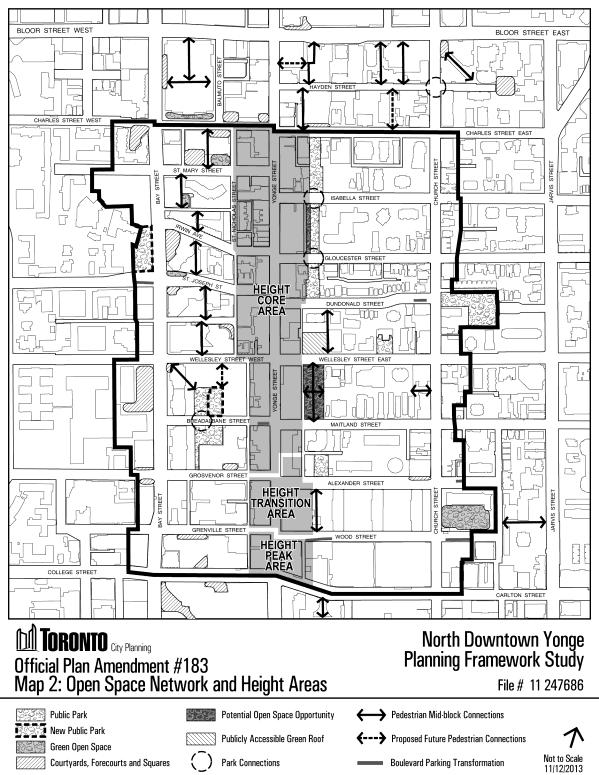
7 All development/redevelopment within the Bay Street Character Area will be located and massed so as to minimize new net shadow impacts on the St. Nicholas Character Area at all times of the day and for all seasons of the year Development/redevelopment must provide an appropriate transition in scale and height between more intensive forms of development/redevelopment in the adjacent Character Areas, such as the Bay Street Character Area, down to the lower-scaled development of the St. Nicholas Character Area. 5.3 Yonge Street Character Area Yonge Street is Toronto's main street. It has played many roles in the development of the city. Today it is a vibrant commercial corridor attracting local residents, workers and visitors to the city and commuters passing through. The Yonge Street Character Area plays a role in connecting and providing an identity to the Character Areas located east and west of it. The Yonge Street Character Area is designated Mixed Use Areas in the Official Plan from Charles Street to Grenville Street and Wood Street along both sides of Yonge Street with an area designated Parks along the easterly boundary of the area between Charles Street East and Dundonald Street. The Yonge Street Character Area abuts areas designated Apartment Neighbourhoods to the east and west as well as an area designated Neighbourhoods between Gloucester and Dundonald Streets to the east. Throughout the Yonge Street Character Area, existing buildings lining Yonge Street display a rhythm of narrow retail frontages that reference the street's historic character. Much of Yonge Street in the Official Plan amendment area between College/Carlton Streets and Charles Street is characterized by a predominantly low-rise main street building typology with a prevailing street wall height of 2 to 4 storeys, retail frontages of around 5 metres in width and shallow lot depths of approximately 18, 25 or 30 metres. The core area is in the centre of the Yonge Street Character Area between Charles Street and Grosvenor Street on the west side of Yonge Street and Charles Street and mid-block between Alexander Street and Maitland Street on the east side of Yonge Street. Both the north and south edges of this area are comprised of transitional height areas rising to height peaks as follows: i) Height Peak Area - located between the intersection of Yonge Street and College/Carlton Street (see Section 5.8 College/Carlton Street Character Area) and Grenville Street and Wood Street, as shown on Map 2, Open Space Network and Height Areas, found at the end of these policies; ii) Height Transition Area - located between Grenville Street and Wood Street and Grosvenor Street on the west side of Yonge Street and mid-block between Alexander Street and Maitland Street on the east side of Yonge Street, as shown on Map 2, Open Space Network and Height Areas, found at the end of these policies.
8 8 Policies: The continued success and unity of the Yonge Street Character Area, and areas to the east and west, will continue to lie in how development and redevelopment in the core, transition and peak areas responds to its historic main street context, reinforcing a pedestrian friendly micro-climate and retail uses along the street. While tall buildings are generally not appropriate throughout this Character Area due to the prevalence of heritage properties and the existing low-rise built form character, exceptions will be recognized, where lot size, depth, specific location and context characteristics (such as heritage values) are able to accommodate a tall building and its servicing and parking requirements Development/redevelopment must create a consistent street wall along Yonge Street to a maximum height of 18 metres or 4 storeys Development/redevelopment must require store frontage widths at grade along Yonge Street to be consistent with the average width of at grade retail that is currently found within 2 blocks to the north and south of a given site along either side of Yonge Street in the North Downtown Yonge Area Development/redevelopment must provide building setbacks to secure a sidewalk zone (measured curb to building face) at least 6 metres wide, or greater where established by the existing context or at corners, transit nodes, PATH access points, or other locations with significant pedestrian use. The sidewalk zone may be entirely public property or a combination of public and private property Development/redevelopment must provide, where commercial uses are planned at grade, building setbacks to secure a sidewalk zone on private property to support adequate space for cafe patios, outdoor displays and other marketing activities As the linear park system to the east of Yonge Street between Charles Street East and Dundonald Street is utilized by the community during all hours of the day, development/redevelopment, within or immediately adjacent to the Yonge Street Character Area, must demonstrate as part of the development application review process that best efforts have been made to not cast any new net shadow on these linear parks during the day for all seasons of the year Development/redevelopment must have: a) a minimum setback of 20 metres from the Yonge Street frontage property line to the tower portion of any tall building development, where heritage properties are present on site; and b) a minimum setback of 10 metres from the Yonge Street frontage property line to the tower portion of any tall building development, where there are no on-site heritage properties.
9 Development/redevelopment must have the tower portion of any tall building development set back a minimum of 20 metres (excluding balconies) from property lines that abut a lower scale Character Area, including any area designated Neighbourhoods in the Official Plan The maximum height within areas identified as "Height Transition Area" in the Yonge Street Character Area, as shown on Map 2, Open Space Network and Height Areas, found at the end of these policies, will be in the range of 45 storeys or 170 metres in height. Applications for these maximum heights will not be approved if the following potential height impacts have not been satisfactorily addressed through the development/redevelopment application review: a) the potential impacts on heritage properties located on or adjacent to the development site; b) the potential impacts on sunlight in parks and open spaces adjacent to the development site; c) the potential impacts on views of prominent and heritage properties, structures and landscapes on or adjacent to the development site; and d) the potential impacts on the site(s) ability to accommodate satisfactory separation and setback distance requirements Any development/redevelopment within the "Height Core Area" of the Yonge Street Character Area, as shown on Map 2, Open Space Network and Height Areas, found at the end of these policies, will conserve, maintain and enhance the existing character, cultural heritage values, attributes and scale of the existing heritage properties and their context. The maximum height within the "Height Core Area" of the Yonge Street Character Area will be in the range of 4 storeys or 18 metres. Buildings higher than 18 metres may only be permitted if: a) no part of the building is located above the angular plane drawn from the Yonge Street lot line, commencing at a height of 18 metres above the street level, and then angling upwards at an angle of 75 degrees away from Yonge Street over the site; and b) where the site contains a heritage property, the heritage property can be retained in its entirety and appropriately incorporated into the development/redevelopment, in keeping with Section 6 of the North Downtown Yonge Site and Area Specific Policy. 5.4 Isabella Character Area The Isabella Character Area is designated in the Official Plan as Mixed Use Areas along the south side of Charles Street East including one site on Isabella Street and Apartment Neighbourhoods for the remainder of the area to Gloucester Street. The area along
10 Policies: 10 Charles Street East, designated Mixed Use Areas, will continue to experience growth and change while the area to the south has remained relatively stable. Significant growth and intensification are not intended for the area south of the properties fronting on Charles Street East to Gloucester Street; however, sensitive low scale infill development that respects and reinforces the general physical character, pattern, scale, massing setbacks and height of this portion of the Isabella Character Area may be permitted All development /redevelopment within the Yonge Street Character Area will be located and massed so as to minimize new net shadow impacts on the Isabella Character Area at all times of the day and for all seasons of the year Where a more intense form of development/redevelopment than the prevailing building types has been approved within or adjacent to the Isabella Character Area, it will not be considered to be the prevailing building type in the assessment of development/redevelopment proposals in the Isabella Character Area Development/redevelopment must provide an appropriate transition in scale and height between more intensive forms of development/redevelopment in the Isabella Character Area down to the lower-scaled development/redevelopment of the Gloucester/Dundonald Character Area The only development/redevelopment permitted within the Mixed Use Areas of Isabella Street and the Apartment Neighbourhoods designated areas of this Character Area, will be sensitive low-rise infill that: a) respects and reinforces the general physical character, pattern, scale, massing, setbacks and heritage value of this Character Area; b) maintains the prevailing patterns of landscaped open space; and c) makes best efforts to preserve and enhance existing private amenity space. 5.5 Gloucester/Dundonald Character Area The Gloucester/Dundonald Character Area is designated Neighbourhoods in the Official Plan between Gloucester Street and Dundonald Street. On the south side of Dundonald Street there is one site designated as Mixed Use Areas with the remainder of the south side of the street designated as Apartment Neighbourhoods in the Official Plan. This Character Area is bounded on the north by Apartment Neighbourhoods and on the south by areas designated Mixed Use Areas, Parks and Apartment Neighbourhoods. Immediately adjacent to the west is the south portion of the linear park system over the Yonge Street subway, designated as Parks. The Gloucester/Dundonald Character Area is a stable area with low-rise residential being the predominant building type. Significant growth and intensification are not intended within this Character Area; however, sensitive low scale infill development that respects
11 Policies: 11 and reinforces the general physical character, pattern, scale, massing setbacks and heritage value of this Character Area, may be permitted Where a more intense form of development/redevelopment than the prevailing building types has been approved within or adjacent to the Gloucester/Dundonald Character Area, it will not be considered to be the prevailing building type in the assessment of development/redevelopment proposals in the Gloucester/Dundonald Character Area The Gloucester/Dundonald Character Area will be protected from new net shadow impacts resulting from development/redevelopment in the adjacent Character Areas. All development/redevelopment within the Yonge Street Character Area, the Wellesley/Wood Character Area and the Church Street Village Character Area will be located and massed so as to minimize new net shadow impacts on the Gloucester/Dundonald Character Area at all times of the day and for all seasons of the year Development/redevelopment must provide an appropriate transition in scale and height between more intensive forms of development/redevelopment in the adjacent Character Areas down to the lower-scaled development/redevelopment of the Gloucester/Dundonald Character Area. 5.6 Wellesley Wood Character Area Policies: The Wellesley Wood Character Area is designated Apartment Neighbourhoods in the Official Plan from north to south partly from Dundonald Street to Maitland Street then fully from Maitland Street to Wood Street. This part of the Character Area is a primarily stable area consisting of "tower in the park" apartment buildings. This Apartment Neighbourhoods area provides a transition to the low-rise Neighbourhoods area to the north and the Mixed Use Areas to the east (Church Street Character Area), south (College/Carlton Street Character Area) and west both within and outside of this Character Area. The Wellesley Wood Character Area is also designated Mixed Use Areas from Dundonald Street to Maitland Street on the west side of the Character Area that extends east along Wellesley Street. Wellesley Street along the north and south side contains a mix of uses including residential, office and retail. It is also the location of a transit node at the Wellesley subway station. This portion of the Character Area may be appropriate for limited infill growth subject to the development policies noted below Development /redevelopment within the Wellesley Wood Character Area will be located and massed so as to minimize new net shadow impacts on adjacent lower-rise areas designated Neighbourhoods and Apartment Neighbourhoods at all times of the day and for all seasons of the year.
12 The only development/redevelopment permitted within the Apartment Neighbourhoods designated areas of this Character Area, will be sensitive low-rise infill that: a) respects and reinforces the general physical character, pattern, scale, massing, setbacks and heritage value of the area; b) maintains the prevailing patterns of landscaped open space; and c) makes best efforts to preserve and enhance existing private amenity space Development/redevelopment must provide an appropriate transition in scale and height between designated Mixed Use Areas where there is more intensive forms of development/redevelopment and lower-scaled development in areas designated Apartment Neighbourhoods within this Character Area and in areas designated Neighbourhoods in the adjacent Character Areas. 5.7 Church Street Village Character Area The heart of the Church Street Village, located between Dundonald Street and Alexander Street to the south, is designated as Mixed Use Areas. The remainder of this Character Area is a mix of areas designated Apartment Neighbourhoods along and in and around Church Street with several pockets of areas designated as Neighbourhoods. Within the Church Street Village Character Area, Church Street has evolved into the village hub of the LGBTQ communities. The village atmosphere provides a welcoming and eclectic environment with a range of uses that provide for both the local community and tourist activity. Church Street Village is the central location of the annual Pride Week celebrations, the largest event of its kind in North America. The hub of the Church Street Village is the 519 Community Centre, which is a heritage designated property surrounded by parkland and is designated Parks. The Church Street Village Character Area is regarded as a stable area that should experience limited growth, both along Church Street and in the residential areas abutting and surrounding it. Development and redevelopment should reinforce the core village area as a low to midrise pedestrian oriented main street with street related retail uses and narrow retail frontages subject to angular provisions for portions of this Character Area. The 519 Church Street community hub and the surrounding park should be protected from new net shadow impacts of development and redevelopment. Opportunities to expand the parkland should be explored as part of any ongoing development approvals in the area. The Church Street Public School site, located within this Character Area, and considered to have valuable publically accessible open space, should also be protected from the new net shadow impacts of development and redevelopment. The area south of Wood Street has been identified as an area suitable for tall building development/redevelopment within a height range of 47 metres to 77m (15 storeys to
13 Policies: storeys) in the Supplementary Downtown Tall Buildings Vision and Design Guidelines. The height for development/redevelopment will be considered provided that these 3 factors are taken into account: the impact of development/redevelopment on sunlight in adjacent parks and open spaces; setback requirements to lower scale areas; and building frontage along "Priority Retail Streets" The only development/redevelopment permitted within the Mixed Use Areas and Apartment Neighbourhoods designated areas of this Character Area will be sensitive low-scale infill that: a) respects and reinforces the general physical character, pattern, scale, massing, setbacks and heritage value of this Character Area; b) maintains the prevailing patterns of landscaped open space; c) respects and reinforces the preservation and enhancement of existing private amenity space; and d) respects and reinforces the fine grain retail at grade (where permitted) and the low-rise scale of existing development Development/redevelopment located within this Character Area between Wood Street and Charles Street East must ensure that no part of any building is located above the angular plane drawn from the Church Street lot line, commencing at a height of 16 metres above the street level, and then angling upwards at an angle of 44 degrees away from Church Street over the site Development/redevelopment within the Church Street Village Character Area will be located and massed so as to minimize new net shadow impacts on areas designated Neighbourhoods Development/redevelopment will cast no new net shadow on the parkland forming part of 519 Church Street community hub for a period of 6 hours generally between the hours of 10:00 AM and 4:00 PM on March 21 st and September 21 st Development/redevelopment must make best efforts as part of the development application review process to not cast new net shadow on the Church Street Public School site throughout the day for all seasons of the year Development/redevelopment must require store frontage widths at grade along Church Street to be consistent with the average width of at grade retail that is currently found within 2 blocks to the north and south of a given site along either side of Church Street in the North Downtown Yonge Area.
14 College/Carlton Street Character Area College/Carlton Street and the area around it is designated as a Mixed Use Areas in the Official Plan. The College/Carlton Street Character Area is a mature area with a diverse mix of office, residential, retail and institutional uses. This area is a key transportation link that is serviced by the College subway station and inter-connecting east/west and north/south streetcar and bus connections. The area includes a number of designated heritage buildings: i) "College Park" located on the south west corner of Yonge Street and College Street which today contains a mix of retail, office, institutional and residential uses; ii) iii) the newly renovated "Maple Leaf Gardens" located at the north west corner of Church Street and Carlton Street, which contains retail and recreational/institutional uses; and "Oddfellows' Hall" which contains a range of commercial uses and is located at the north-west intersection of College and Yonge Streets. Policies: Higher intensity development/redevelopment is anticipated for portions of the College/Carlton Street Character Area. The intersection of Yonge Street and College Street is identified as a "Height Peak Area" in the North Downtown Yonge Urban Design Guidelines The maximum height within areas identified as "Height Peak Area" in the College/Carlton Street Character Area, as shown on Map 2, Open Space Network and Height Areas, found at the end of these policies, will be in the range of 55 storeys or 190 metres in height. Development/redevelopment applications for these maximum heights in the Height Peak Area may only be considered for approval if the following potential impacts of height have been satisfactorily addressed, as part of the development/redevelopment application review process: a) the potential impacts on heritage properties located on or adjacent to the development site; b) the potential impacts on sunlight in parks and open spaces in proximity to the development site; and c) the potential impacts on views of prominent and heritage properties, structures and landscapes on or adjacent to the development site Development/redevelopment must provide an appropriate transition in scale and height between more intensive forms of development and redevelopment in the College/Carlton Street Character Area down to the lower-scaled development in the Wellesley Wood Character Area and Church Street Village Character Area.
15 Development/redevelopment must provide building setbacks to secure a sidewalk zone (measured curb to building face) at least 6 metres wide, or greater where established by the existing context or at corners, transit nodes, PATH access points, or other locations with significant pedestrian use. The sidewalk zone may consist entirely of public property or a combination of public and private property Where commercial uses are planned at grade, development/redevelopment must provide building setbacks to secure a sidewalk zone on private property to support adequate space for cafe patios, outdoor displays and other marketing activities Development/redevelopment must have: a) a minimum setback of 20 metres from the Yonge Street frontage property line to the tower portion of any tall building development where heritage properties are present on site; and b) a minimum setback of 10 metres from the Yonge Street frontage property line to the tower portion of any tall building development where there is no on-site heritage The maximum height for the area located along the south of Wood Street for properties fronting onto Church Street within the Church Street Village Character Area will be in the range of 47 metres to 77 metres (15 storeys to 25 storeys) Development/redevelopment applications for these maximum heights may only be considered for approval if the following potential impacts of height have been satisfactorily addressed, as part of the development/redevelopment application review process: a) the potential impacts on heritage properties located on or adjacent to the development site; b) the potential impacts on sunlight in parks and open spaces adjacent to the development site; c) the potential impacts on views of prominent and heritage properties, structures and landscapes on or adjacent to the development site; and d) the potential impacts on the given site(s) accommodating satisfactory separation and setback distance requirements Development/redevelopment must require store frontage widths at grade along Yonge Street and Church Street to be consistent with the average width of at grade retail that is currently found within 2 blocks to the north and south of a given site along either side of Yonge Street or Church Street in the North Downtown Yonge Area.
16 6. AREA WIDE POLICIES 16 The Area Wide Policies detailed below will be further informed by the North Downtown Yonge Urban Design Guidelines adopted by Council in June of 2013, with revisions adopted by Council in October 2013, and such further revisions as may be adopted by Council from time to time and by the city-wide Tall Buildings Design Guidelines and Supplementary Downtown Tall Buildings Vision and Design Guidelines, adopted by Council in May of 2013, and such further revisions as may be adopted by Council from time to time. 6.1 Heritage Policies: The North Downtown Yonge Site and Area Specific Policy has a strong heritage fabric throughout all of its Character Areas with the largest number of heritage properties being located along Yonge Street. Heritage properties, buildings, or landscapes within the North Downtown Yonge Site and Area Specific Policy area have been either listed or designated on the City of Toronto Heritage Register (City of Toronto Inventory of Heritage Properties) or identified as potential heritage properties to be protected under the Ontario Heritage Act at a future time. Historic Yonge Street Heritage Conservation Study Area The area in and around Yonge Street from College/Carlton Streets north to Davenport Road, has also been identified as a potential Heritage Conservation District (HCD). A study process is currently underway to determine if a Heritage Conservation District Plan (HCD) will be warranted for this area Development/redevelopment and alterations within the North Downtown Yonge Area will respect, conserve and maintain the integrity of the cultural heritage values and attributes of heritage properties throughout the area Development/redevelopment will provide appropriate transition through setbacks, stepbacks and stepping down of height in order to protect and mitigate negative impacts upon heritage properties, significant views and the distinctive characteristics of potential or existing heritage conservation districts Buildings possessing cultural heritage value or interest and potential cultural heritage landscapes will be evaluated, protected and conserved in accordance with relevant legislation, including the Ontario Heritage Act and the Planning Act, as well as provincial policy, the heritage policies in the City of Toronto Official Plan, the policies of this area specific OPA and the Standards and Guidelines for the Conservation of Historic Places in Canada.
17 Heritage Impact Assessments will be required for development applications that affect identified and potential heritage properties within this policy area Wherever possible, development/redevelopment will conserve built and landscape heritage properties and be of a scale, form and character that supports, complements and integrates these resources. Development/redevelopment will mitigate any potential negative impact upon a heritage property or potential heritage property Areas identified as having archaeological potential are shown on the City of Toronto Archaeological Master Plan. Any soil disturbance or proposed development/redevelopment in areas of potential will require a Stage 1-2 Archaeological Assessment to be submitted during the development application review process Heritage properties will be conserved in any development/redevelopment sites as described in further detail in the Character Area policies and consistent with the Standards and Guidelines for the Conservation of Historic Places in Canada and the City of Toronto Official Plan, as amended. 6.2 Park and Open Space Policies: The parks and open space system is a fundamental element to providing recreational opportunities and spaces for social activity. The North Downtown Yonge Area has been identified as a park deficient area according to city standards. The existing park space consists of a small linear public park system east of Yonge Street running north-south over the Yonge subway line. In addition to the linear park system, there are several small dispersed park blocks that are poorly connected to pedestrian pathways, sidewalks, buildings and to the overall parks network. The open space system consists primarily of privately owned publicly accessible open space (including courtyards, forecourts and squares), school yards and publicly accessible green roofs. There are several opportunities to increase the amount of public park land and privately owned publically accessible open space. However, the priority within the North Downtown Yonge Area will be to: expand existing parkland wherever possible so as to create larger more viable parcels; provide more parkland through dedication and acquisition; and, create linkages between parks and open spaces. The parks and open space system will be comprised of a hierarchy of spaces that include existing and potential parks and open spaces such as plaza courtyards, forecourts, and squares as shown on Map 2, Open Space Network and Height Areas, found at the end of these policies. The parks and open space system will be linked by a continuous system of easy to access and easy to use accessible open space linkages that will also reflect the area's heritage character It is the objective of Council to create new parks and open space wherever possible through innovative parkland acquisition and through privately owned publically accessible open space.
18 It is the objective of Council to encourage the assembly of land for park purposes through on-site and/or off-site parkland dedication as part of the development/redevelopment application review process It is the objective of Council to provide accessible, high quality, barrier free and well designed parks, plazas and open spaces It is the objective of Council to provide new parkland, as opportunities arise, within the North Downtown Yonge Area, including: a) the creation of a parkette generally under 0.5 hectares in size, as part of the redevelopment of the Toronto Parking Authority lot at 15 Wellesley Street East; b) the expansion of Norman Jewison Park to the west through the transfer of land from the Toronto Parking Authority; c) the creation of a neighbourhood park generally over 0.5 hectare in size at 11 Wellesley Street West to be located on the south side of Wellesley Street West, west of Yonge Street; and d) the expansion of Breadalbane Park on the north side of Breadalbane Street For the area west of Yonge Street and north of Wellesley Street West, it is the objective of Council to provide opportunities for on-site dedications and new and improved publically accessible open space as part of the development/redevelopment application review process For the area east of Yonge Street, between Charles Street East and Carlton Street, it is the objective of Council to expand the existing parks network through off-site and on-site dedications and/or acquisitions that form part of the development/redevelopment application review process It is the objective of Council to create opportunities for greening and additional park and open space linkages through the creation and addition of plaza forecourts, tree plantings, green or enhanced streetscapes, and boulevard parking reclamations It is the objective of Council to protect sunlight in parks by mitigating or eliminating shadow impacts of development and redevelopment on parks and open spaces It is the objective of Council to ensure that development/redevelopment will not cast any new net shadow on Opera Place Park Street between 12 Noon and 2:00 PM on March and September 21 st, and should the opportunity arise to expand Breadalbane Park, for a period of 6 hours generally between the hours of 10:00 AM and 4:00 PM on March 21 st and September 21 st It is the objective of Council, as part of development/redevelopment application review process, to provide linkages and strong physical connections between the linear parks and
19 19 to create or improve existing pedestrian connections to existing parks and open space as well as to potential parks and open space and in particular: a) the linear park system east of Yonge Street that extends between Charles Street East and Dundonald Street; and b) the potential open space at 15 Wellesley Street East, Alexander Park, the potential parkland at 11 Wellesley Street West, and Cawthra Park. 6.3 The Public Realm Policies: The public realm is comprised of streets, parks, civic buildings and other publicly owned and publically accessible land that give an area its sense of place. The quality, attractiveness and character of the public realm relates directly to the quality of the surrounding development including public art, private courtyards, plazas, development setbacks, walkways, patios, accessible rooftops and overall building design. The following public realm policy objectives will guide development review and public realm planning as appropriate It is the objective of Council to enhance streetscape design through tree plantings, paving materials, street furniture, landscape planters, decorative pedestrian scale street lighting and public art It is the objective of Council to expand and improve public spaces through enhanced streetscape design, tree planting, street furniture, pavement treatment, well-designed and barrier-free sidewalks or other paths of travel It is the objective of Council to enhance the design of the rights-of-way of the Yonge Street and Church Street to improve pedestrian comfort, safety and utility It is the objective of Council to review development/redevelopment applications in terms of achieving the following public laneway improvement objectives as part of the development application review process: a) a minimum laneway width of 6 metres; b) additional setbacks, where possible as part of the development application review process, in order to better accommodate north-south pedestrian connections and movement through the area; c) raised or well demarcated and barrier-free paths of travel along the laneways to improve pedestrian safety and movement; and d) re-surfacing of laneways with brick pavers or other materials, where appropriate, to complement the heritage character of the area.
20 It is the objective of Council to encourage at-grade commercial uses along the following public laneways in the area: St. Vincent Lane; St. Luke Lane; Reverend Porter Lane; Gloucester Lane; and, Maitland Terrace It is the objective of Council to create an enhanced the public realm and support pedestrian movement by expanding the sidewalk width, mid-block access, well designed promenades and potential new mid-block connections It is the objective of Council to design and locate public realm elements within a given Character Area to have consideration for interconnectivity with adjacent Character Areas and with the surrounding neighbourhoods It is the objective of Council to integrate lighting, furniture, paving and landscaping on private lands with those on public lands It is the objective of Council to incorporate forecourts and sidewalks for street activities, sidewalk cafes and spill-out retail It is the objective of Council to expand and improve pedestrian and cycling linkages as part of the development/redevelopment application review process It is the objective of Council to plan and design the public realm to encourage walking, cycling, transit use, and car sharing as means to reduce the use of private automobiles It is the objective of Council to encourage opportunities for additional transit access locations and for internalizing new subway access locations into buildings to address increasing population and employment in the area, while ensuring that internalized subway entries do not negatively impact heritage properties It is the objective of Council to widen the setbacks on east-west streets as part of the development/redevelopment application review process to widen sidewalks to a minimum width of 6 metres It is the objective of Council to create gateways into Character Areas that accentuate entry points through distinctive architectural design, façade treatment, special landscape, plazas and open spaces and public art installations It is the objective of Council to terminate view corridors with distinct architectural design and landscape design and public art installations It is the objective of Council that views the following properties on the heritage register will be conserved, consistent with the view protection policies of Sections and of the Official Plan. Public and private development will preserve views to these heritage properties as follows:
21 21 a) College Park [H], 444 Yonge Street College Park can be viewed from several vantage points within the Yonge Street corridor. The entirety of its east facing facade can be viewed from the north-east corner of Yonge Street and Wood Street. The entire north facing façade can be viewed from College Street and the north-east corner of Bay Street. Both facades can be viewed together from the north-east corner of Yonge Street and Carlton Street. b) OddFellows' Hall [H], 2 College Street and 450 Yonge Street The Oddfellows' Hall located on the north-west corner of Yonge Street and College Street can be viewed from several vantage points in the Yonge Street and College/Carlton Street corridor. The east facing façade and towers of the property can be viewed from the north-east corner of Alexander Street and Yonge Street, as well as from the south-east corner of Carlton Street and Yonge Street. The property can be seen in its entirety from the south-east corner of Yonge Street and Carlton Street as well as from the sidewalk on the south side of Carlton Street in front of the drive way entrance to 25 Carlton Street. c) Masonic Hall [H], Yonge Street, 2 Gloucester Street The Masonic Hall at the north-east corner of Yonge Street and Gloucester Street can be viewed in its entirety looking north from the north-west corner of Yonge Street and St. Joseph Street. The prominent tower and west facing facade can be viewed from Irwin Avenue and St. Nicholas Lane as well as Cottage Lane. Its southern façade and corner tower can also be seen from the south side of Gloucester Street when viewed from the northern entry to James Canning Park. d) Clock Tower [H], 484 Yonge Street The fire hall clock tower on the west side of Yonge Street, located mid-block between Grenville Street and Grosvenor Street can be viewed from the corners of Grosvenor Street and Yonge Street as well as the corners of Grenville Street and Yonge Street. The tower is also a prominent view from the west side of Yonge Street between the south side of College/Carlton Street and north side of Charles Street. The properties noted above will be added to maps 7a and 7b of the Official Plan, upon implementation of OPA 199. View measurement points to the heritage properties noted above will be to the satisfaction of City of Toronto Heritage Preservation Services staff It is the objective of Council that a Heritage Impact Assessment should be required where a development/redevelopment application may obstruct or detract from a view included in this Site and Area Specific Policy.
22 Urban Design Policies: Revitalization within the North Downtown Yonge Site and Area Specific Policy is expected to occur through redevelopment, renewal and infill. Together with the policies of the North Downtown Yonge Site and Area Specific Policy, new development will be further informed by the North Downtown Yonge Urban Design Guidelines, the Tall Building Design Guidelines and the Downtown Tall Buildings Vision and Supplementary Design Guidelines Development/redevelopment will have a high standard of design, be appropriately scaled, relate positively to the existing and planned context and contribute to enhancing the surrounding public realm Development/redevelopment will provide for a transition from higher building forms to adjacent lower scale areas to fit to its surroundings with setbacks, stepbacks, height restrictions, angular planes, appropriate floorplate areas and façade articulation being used to achieve appropriate transition in scale The portion of the base building of a tall building immediately adjacent to the lower scale area will generally be no higher than the height of the adjacent buildings, transitioning into a higher base as the distance from the lower scale area increases Where a tall building is proposed close to a lower scale area residential area, the tower portion of the tall building will be set back a minimum of 20 metres, excluding balconies, from any such abutting property line The tower portions of tall building development will have floor plate sizes and tower separation distances that protect access to sunlight, sky view and privacy as more fully identified in the Tall Buildings Design Guidelines and Downtown Tall Buildings Vision and Supplementary Design Guidelines Above grade parking is not permitted except where a property is located directly above the Yonge subway line and it is demonstrated that it is not possible to construct below grade parking because of the subway. Above grade parking will be lined with residential units, offices, retail, institutional or indoor recreational uses on exterior walls so that the above grade parking is not visible Tall buildings will not generally be permitted on: a) sites that are not able to meet the separation, stepback and setback distance requirements of the North Downtown Yonge Urban Design Guidelines, the Tall Buildings Design Guidelines and Downtown Tall Buildings Vision and Supplementary Design Guidelines; and b) have an existing or planned context which does not contemplate tall buildings as a suitable form of development.
23 Incentives The policies of Section of the Official Plan regarding Section 37 of the Planning Act will apply to the North Downtown Yonge Site and Area Specific Policy, with the additional following policy direction. In determining community benefits the following will be considered priorities, although others may also be secured, as appropriate, and should be considered in the context of the policies of the Official Plan, the North Downtown Yonge Site and Area Specific Policy and the North Downtown Yonge Urban Design Guidelines: i) improvements and expansions to local parks; ii) iii) iv) establishment of new or expansions to existing non-profit community services and facilities, including community service program space; non-profit childcare facilities; improvements to local library facilities; v) affordable housing; vi) vii) public art; and improvements to public transit and PATH system connections. 6.6 Interpretation This North Downtown Yonge Site and Area Specific Policy should be read as a whole and with the policies of the Official Plan to understand its comprehensive and integrative intent as a policy framework for decision making This North Downtown Yonge Site and Area Specific Policy has its policies under the heading of "Policies". Additional text has been provided in addition to the "Policies" to provide context and background and to assist in better understanding the intent of the Area Specific policies Where the policies of this North Downtown Yonge Site and Area Specific Policy state "in the range of" in relationship to "Height Peak" and "Height Transition" areas in the Yonge Street Character Area and the College/Carlton Character Area, this reference to range is intended to not exceed 3 storeys or 10 metres (rooftop mechanicals included) above the Height stated in the given policies Where the policies of this North Downtown Yonge Site and Area Specific Policy state that development/redevelopment should be located and massed so as to "minimize shadow impacts" or "minimize new net shadow impacts" either within the character area or on an adjacent lower rise area, this is intended to mean that:
24 24 a) shadow should be adequately reduced or limited on lower rise areas and Neighbourhoods to preserve the utility of their open spaces, whether these be private or public; and b) in reference to shadow on specific parks, shadow should be adequately reduced, minimized or eliminated to preserve the utility of the given park for those periods of time and seasons when the park is most heavily used by the public Where the policies of this North Downtown Yonge Site and Area Specific Policy state that development/redevelopment within or immediately adjacent to an area should demonstrate that "best efforts have been made to not cast any new net shadow" this is intended to mean that recognized planning tools and performance standards have been employed to analyze the impact of new development/redevelopment on creating shadow, through the completion of sun-shadow studies, massing studies, building orientation and location studies and floor plate size analysis. The sun-shadow study analysis should include specific time periods and seasons during which it has been determined that shadowing should be avoided in the context of a given Character Area and/or specific park The policies of the Official Plan apply to the North Downtown Yonge Site and Area Specific Policy area, save and except in the case of any conflict with the Official Plan, in which case the North Downtown Yonge Site and Area Specific Policies prevail.
25 25
26 26
Toronto Urban Design Guidelines. North Downtown Yonge
 Toronto Urban Design Guidelines North Downtown Yonge City Planning Table of contents 1. Introduction... 1 1.1 North Downtown Yonge Objectives... 2 1.2 Location / Study Area... 3 2. Heritage... 5 2.1 History
Clairtrell Area Context Plan
 Clairtrell Area Context Plan March 2005 Urban Development Services City Planning Contents 1. Introduction... 4 2. Development Structure... 6 2.1 Streets... 7 2.1.1 Sheppard Avenue and Bayview Avenue...
QUEEN-RIVER SECONDARY PLAN
 34 QUEEN-RIVER SECONDARY PLAN 34. QUEEN RIVER SECONDARY PLAN 1. INTRODUCTION The Queen-River area is approximately 6.4 hectares and is located at the eastern edge of the Downtown as shown on Map 34-1.
DRAFT Northeast Quadrant of Kipling Avenue and Highway 7 DRAFT AUGUST 29, Goals Land Use. The goals of this Plan are to:
 AUGUST 29, 2017 12.15 Northeast Quadrant of Kipling Avenue and Highway 7 12.15.1 Goals 12.15.2 Land Use The goals of this Plan are to: 12.15.2.1 General Provisions: a) Ensure the development of a compact
URBAN DESIGN BRIEF. 2136&2148 Trafalgar Road. Town of Oakville
 URBAN DESIGN BRIEF 2136&2148 Trafalgar Road Town of Oakville Prepared By: METROPOLITAN CONSULTING INC For 2500674 Ontario Inc November 2016 TABLE OF CONTENTS Page No. 1.0 Introduction/Description of Subject
Historic Yonge Street HCD Study Public Meeting #2
 Historic Yonge Street HCD Study Public Meeting #2 March 26, 2014 Archaeological Services Inc. Philip Goldsmith Architect Agenda: 7:00 p.m. Open House 7:30 p.m. Welcome and Presentation 8:00 p.m. Questions
Wide asphalt driveway abutting school property. garage built with incompatible materials, too close to park. incompatible fencing materials
 Wide asphalt driveway abutting school property incompatible fencing materials garage built with incompatible materials, too close to park Lack of plantings as a buffer between private property and open
BROADVIEW PLANNING STUDY Community Consultation Meeting 4. January 2016
 BROADVIEW PLANNING STUDY Community Consultation Meeting 4 January 2016 2 Agenda 6:00 pm Open House and Displays 7:00 pm Introductions, Agenda Review and Welcome 7:10 pm Presentation Broadview Planning
King-Spadina Secondary Plan Community Consultation Meeting. Michelle Knieriem, City Planner October 11, 2017
 King-Spadina Secondary Plan Community Consultation Meeting Michelle Knieriem, City Planner October 11, 2017 Agenda 6:30 Welcome 6:35 Presentation 7:15 Question and Answer Session 8:15 Closing Remarks HOW
Historic Yonge Street HCD Plan Community Consultation October 14, 2015
 Historic Yonge Street HCD Plan Community Consultation October 14, 2015 Archaeological Services Inc. Philip Goldsmith Architect BRAY Heritage Historic Yonge Street HCD Plan Agenda: 6:30 Open House 7:30
THE CITY OF VAUGHAN BY-LAW BY-LAW NUMBER A By-law to adopt Amendment Number 1 to the Official Plan of the Vaughan Planning Area.
 THE CITY OF VAUGHAN BY-LAW BY-LAW NUMBER 015-2014 A By-law to adopt Amendment Number 1 to the Official Plan of the Vaughan Planning Area. NOW THEREFORE the Council of the Corporation of the City of Vaughan
Official Plan Review: Draft Built Form Policies
 PG.30.1 REPORT FOR ACTION Official Plan Review: Draft Built Form Policies Date: May 15, 2018 To: Planning and Growth Management Committee From: Chief Planner and Executive Director, City Planning Division
burlington mobility hubs study Downtown Burlington Mobility Hub
 burlington mobility hubs study Downtown Burlington Mobility Hub Draft Precinct Plan Workbook PIC #3, September 7, 2017 downtown mobility hub objectives City staff and their consultants are proposing an
ELMVALE ACRES SHOPPING CENTRE MASTER PLAN
 ELMVALE ACRES SHOPPING CENTRE MASTER PLAN Contents 1.0 INTRODUCTION... 2 2.0 LOCATION... 2 3.0 EXISTING CONTEXT... 2 4.0 VISION & GUIDING PRINCIPLES... 2 5.0 LAND USE AND BUILT FORM... 4 5.1 St. Laurent
DRAFT DRAFT DRAFT DRAFT
 # 19 EXPAND GREEN AND OPEN SPACES AND COMMUNITY FACILITIES IN TANDEM WITH NEW DEVELOPMENT The role of Eglinton will change in the coming years, along with the intensity of activity and land uses. As more
Mark-up of the effect of the proposed Bronte Village Growth Area OPA No.18 on the text of section 24, Bronte Village, of the Livable Oakville Plan
 Mark-up of the effect of the proposed Bronte Village Growth Area OPA No.18 on the text of section 24, Bronte Village, of the Livable Oakville Plan Notes: This document is provided for information purposes
50 Wellesley Street East and Dundonald Street Official Plan Amendment and Zoning Amendment Applications Request for Direction Report
 STAFF REPORT ACTION REQUIRED 50 Wellesley Street East and 31-35 Dundonald Street Official Plan Amendment and Zoning Amendment Applications Request for Direction Report Date: November 2, 2015 To: From:
YONGE STEELES CORRIDOR SECONDARY PLAN. Young + Wright / IBI Group Architects Dillon Consulting Ltd. GHK International (Canada) Ltd.
 Ltd.") PART A: PREAMBLE 1.0 PURPOSE The purpose of this Secondary Plan is to provide a development framework for intensification of the Yonge/ Steeles corridor including the north side of Steeles Avenue West
PART A: PREAMBLE 1.0 PURPOSE The purpose of this Secondary Plan is to provide a development framework for intensification of the Yonge/ Steeles corridor including the north side of Steeles Avenue West
CONTENTS 8.0 LAND USE 8.1 GENERAL LAND USE 8.2 RESIDENTIAL 8.3 MIXED USE 8.4 COMMERCIAL 8.5 EMPLOYMENT LANDS
 8-2 Land Use 8.0 LAND USE CONTENTS 8.1 GENERAL LAND USE 8.1.1 Uses provided for in all Land Use Designations 8.1.2 Uses prohibited in Hazardous Lands, Hazardous Sites and Special Policy Areas 8.1.3 Uses
Urban Design Brief to 1557 Gordon Street & 34 Lowes Road West
 Urban Design Brief 1533 to 1557 Gordon Street & 34 Lowes Road West Reid s Heritage Homes Ltd. & 883928 Ontario Ltd. and RHH Property Management Ltd. City of Guelph Zoning By-law Amendment November 2017
11.5 Kipling Avenue Corridor Secondary Plan
 11.5 Kipling Avenue Corridor Secondary Plan ADOPTED BY VAUGHAN CITY COUNCIL NOT YET APPROVED BY THE ONTARIO MUNICIPAL BOARD 11.5.1 Development Principles and Objectives The following principles support
(DC1) Direct Development Control Provision DC1 Area 4
 Direct Development Control Provision DC1 Area 4") . General Purpose (DC) Direct Development Control Provision DC Area 4 The purpose of this Provision is to provide for an area of commercial office employment and residential development in support of the
. General Purpose (DC) Direct Development Control Provision DC Area 4 The purpose of this Provision is to provide for an area of commercial office employment and residential development in support of the
URBAN DESIGN BRIEF URBAN DESIGN BRIEF 721 FRANKLIN BLVD, CAMBRIDGE August 2018
 URBAN DESIGN BRIEF URBAN DESIGN BRIEF 721 FRANKLIN BLVD, CAMBRIDGE August 2018 DESIGN BRIEF CONTENTS PART A 1.0 INTRODUCTION 2.0 DESCRIPTION & ANALYSIS OF SITE CONTEXT 3.0 DESIGN CONSTRAINTS AND OPPORTUNITIES
2, 6 & 8 Gloucester Street and Yonge Street Zoning Amendment Application Final Report
 STAFF REPORT ACTION REQUIRED 2, 6 & 8 Gloucester Street and 601 613 Yonge Street Zoning Amendment Application Final Report Date: March 7, 2013 To: From: Wards: Reference Number: Toronto and East York Community
appendix and street interface guidelines
 appendix five: building and street interface guidelines appendix 5 building and street interface guidelines BOULEVARDS Boulevards are generally characterized by higher levels of traffic movement at higher
Yonge Eglinton Centre Urban Design Guidelines
 Yonge Eglinton Centre Urban Design Guidelines City Planning Urban Design January 2009 YONGE EGLINTON CENTRE INTRODUCTION.................................................... 1 GENERAL SITE PLAN OBJECTIVES......................................
Regency Developments. Urban Design Brief. Holyrood DC2 Rezoning
 Regency Developments Urban Design Brief Holyrood DC2 Rezoning Stantec Consulting Ltd. 7-31-2017 1. Overview Regency Developments intends to rezone the lands located at 8510 and 8511 93 Avenue, within the
College Street Study Official Plan Amendment Final Report
 STAFF REPORT ACTION REQUIRED College Street Study Official Plan Amendment Final Report Date: April 10, 2017 To: From: Wards: Reference Number: Toronto and East York Community Council Director, Community
*** DRAFT 2 FOR PUBLIC REVIEW ***
 6.7 The area is generally bounded by the Red Hill Valley Parkway to the west, Lake Avenue to the east, the Queen Elizabeth Way (QEW) to the north, and by the properties just south of Queenston Road to
New-Cast Mixed-use Development Proposal King Street West, Newcastle, Ontario
 URBAN DESIGN BRIEF New-Cast Mixed-use Development Proposal King Street West, Newcastle, Ontario TABLE OF CONTENTS: 1.0 Executive Summary 2.0 Creating Vibrant and Sustainable Urban Places: Excerpts from
Bathurst Bloor Four Corners Study Official Plan Amendment and Zoning By-law Amendment Final Report
 STAFF REPORT ACTION REQUIRED Bathurst Bloor Four Corners Study Official Plan Amendment and Zoning By-law Amendment Final Report Date: November 2, 2016 To: From: Wards: Reference Number: Toronto and East
Urban Design Brief. Watson Parkway North & Watson Road North Guelph, Ontario. Prepared by Coletara Development
 Urban Design Brief Watson Parkway North & Watson Road North Guelph, Ontario Prepared by Coletara Development December, 2013 Urban Design Brief, Coletara Development 1 Introduction This Urban Design Brief
Trafalgar Road Corridor Planning Study Open House
 Trafalgar Road Corridor Planning Study Open House June 24, 2013 6:30-8:30 p.m. Oakville & Trafalgar Rooms Overview The Livable Oakville Plan identifies the lands along Trafalgar Road, between the QEW and
Urban Design Manual PLANNING AROUND RAPID TRANSIT STATIONS (PARTS) Introduction. Station Study Areas
 Introduction. Station Study Areas") 111111 PLANNING AROUND RAPID TRANSIT STATIONS (PARTS) Introduction The ION rapid transit system will link Waterloo, Kitchener and Cambridge through a central transit corridor (CTC). There are a number
111111 PLANNING AROUND RAPID TRANSIT STATIONS (PARTS) Introduction The ION rapid transit system will link Waterloo, Kitchener and Cambridge through a central transit corridor (CTC). There are a number
Queen Street East/Ashbridge Precinct Planning Study- City-Initiated Official Plan Amendment and Urban Design Guidelines Final Report
 STAFF REPORT ACTION REQUIRED Queen Street East/Ashbridge Precinct Planning Study- City-Initiated Official Plan Amendment and Urban Design Guidelines Final Report Date: December 15, 2015 To: From: Wards:
5.1 Site Plan Guidelines
 5. Community Core Guidelines Development of the Community Core will take place by plan of subdivision and site plan approval. It will occur in a phased manner that will reflect the timing of residential
WINDSOR GLEN DESIGN GUIDELINES
 WINDSOR GLEN DESIGN GUIDELINES Adopted by Council, 2006 WINDSOR GLEN REDEVELOPMENT DESIGN GUIDELINES August 2006 1.0 Master Plan Organization For this area of the Coquitlam Town Centre, a mix of high,
The Master Plan Framework
 The Master Plan Framework The East Harbour Master Plan advances the development of 60 acres of former industrial lands east of the Don River. The Master Plan outlines a vision for a vibrant, transit-oriented
Old East Village Dundas Street Corridor Secondary Plan
 Old East Village Dundas Street Corridor Secondary Plan DRAF T February 2019 Contents 1.0 INTRODUCTION 1 1.1 Background 1 1.2 Location 2 1.3 Purpose and Use 3 1.4 Vision and Principles 4 2.0 CHARACTER
Complete Neighbourhood Guidelines Review Tool
 Complete Neighbourhood Guidelines Review Tool Prepared By: City of Regina Planning Department October 2014 Page 1 of 14 Community Development Review Checklist for Secondary Plans and Concept Plans The
Welcome. Walk Around. Talk to Us. Write Down Your Comments
 Welcome This is an information meeting introducing the applications for proposed redevelopment of the Yorkdale Shopping Centre site at 3401 Dufferin Street and 1 Yorkdale Road over the next 20+ years,
URBAN DESIGN BRIEF Gordon Street City of Guelph. Prepared on behalf of Ontario Inc. March 25, Project No. 1507
 URBAN DESIGN BRIEF 1131 Gordon Street City of Guelph Prepared on behalf of 1876698 Ontario Inc. March 25, 2016 Project No. 1507 423 Woolwich Street, Suite 201, Guelph, Ontario, N1H 3X3 Phone (519) 836-7526
Avenue Road and Pears Avenue - Zoning Amendment Application - Preliminary Report
 STAFF REPORT ACTION REQUIRED 183-189 Avenue Road and 109-111 Pears Avenue - Zoning Amendment Application - Preliminary Report Date: March 9, 2017 To: From: Wards: Reference Number: Toronto and East York
City-initiated Official Plan Amendment for the Gooderham & Worts Special Identity Area, Triangle Lands and Portions of the West Don Lands Final Report
 STAFF REPORT ACTION REQUIRED City-initiated Official Plan Amendment for the Gooderham & Worts Special Identity Area, Triangle Lands and Portions of the West Don Lands Final Report Date: May 26, 2017 To:
DAVENPORT VILLAGE SECONDARY PLAN
 27 DAVENPORT VILLAGE SECONDARY PLAN 27. DAVENPORT VILLAGE SECONDARY PLAN 1. VISION FOR THE DAVENPORT VILLAGE SECONDARY PLAN Davenport Village, municipally known as 830, 940, 980 and 1100 Lansdowne Avenue,
Uptown Rideau Street Secondary Plan [Amendment #166, January 12, 2016]
![Uptown Rideau Street Secondary Plan [Amendment #166, January 12, 2016]](/thumbs/76/73760497.jpg "Uptown Rideau Street Secondary Plan [Amendment #166, January 12, 2016]") [Amendment #166, January 12, 2016] The policies of this Secondary Plan are in effect, save and except for the property at 560 Rideau Street, for which there remains a site specific appeal to this Secondary
[Amendment #166, January 12, 2016] The policies of this Secondary Plan are in effect, save and except for the property at 560 Rideau Street, for which there remains a site specific appeal to this Secondary
SCHEDULE 'A' TO BY-LAW as Amended by AMENDMENT NO. 90 TO THE WHITBY OFFICIAL PLAN
 SCHEDULE 'A' TO BY-LAW 6413-10 as Amended by 6553-11 AMENDMENT NO. 90 TO THE WHITBY OFFICIAL PLAN SECTION A: GROWTH PLAN CONFORMITY PURPOSE: LOCATION: BASIS: The purpose of this Amendment is to: conform
Buildings may be set back to create small plazas provided that these setbacks do not substantially disrupt the street wall s continuity.
 6-22 Community Design Street Walls and Street-front Setbacks The siting of buildings will play a critical role in establishing the character and sense of place for the District. Siting buildings at the
[PLANNING RATIONALE] For Site Plan Control and Lifting of Holding Zone By-Law 101 Champagne Avenue. May 23, 2014
![[PLANNING RATIONALE] For Site Plan Control and Lifting of Holding Zone By-Law 101 Champagne Avenue. May 23, 2014](/thumbs/75/71599615.jpg "[PLANNING RATIONALE] For Site Plan Control and Lifting of Holding Zone By-Law 101 Champagne Avenue. May 23, 2014") [PLANNING RATIONALE] For Site Plan Control and Lifting of Holding Zone By-Law 101 Champagne Avenue May 23, 2014 Contents 1.0 Introduction... 2 2.0 Site Context... 2 2.1 Adjacent Uses... 2 Figure 1: Site
[PLANNING RATIONALE] For Site Plan Control and Lifting of Holding Zone By-Law 101 Champagne Avenue May 23, 2014 Contents 1.0 Introduction... 2 2.0 Site Context... 2 2.1 Adjacent Uses... 2 Figure 1: Site
Context Plan and Urban Design Guidelines for the lands west of Provost Drive
 Concord Park Place Context Plan and Urban Design Guidelines for the lands west of Provost Drive Amendment to the Bessarion-Leslie Context Plan October 2013 Concord Park Place Urban Design Guidelines The
PORT WHITBY COMMUNITY
 PORT WHITBY COMMUNITY SECONDARY PLAN UPDATE COMMUNITY IMPROVEMENT PLAN URBAN DESIGN GUIDELINES September 2015 DRAFT PROPOSED AMENDMENT NUMBER # to the Whitby Official Plan PURPOSE: The intent of this Amendment
4.0 Design Guidelines For The Village Centre. South fields Community Architectural Design Guidelines Town of Caledon
 4.0 Design Guidelines For The Village Centre 4.0 Design Guidelines for the Village Centre The Village Centre is the focal point of the entire South Fields Community and is designed as a traditional commercial
East Bayshore Road Neighbourhood
 East Bayshore Road Neighbourhood Northridge Property Management Urban Design Brief 3195 East Bayshore Road City of Owen Sound January 2016 East Bayshore Road Neighbourhood Northridge Property Management
City of Vaughan Urban Design Guidelines for Infill Development in Established Low-Rise Residential Neighbourhoods
 City of Vaughan Urban Design Guidelines for Infill Development in Established Low-Rise Residential Neighbourhoods DRAFT - September 2016 Contents 1. Introduction 1 2. Policy Context 3 3. Characteristics
TALL BUILDING GUIDELINES
 TALL BUILDING GUIDELINES Urban Design Guidance for the Site Planning and Design of Tall Buildings in Milton May, 2018 A Place of Possibility Contents 1.0 INTRODUCTION 1 1.1 What is a Tall Building? 2
Urban Design Guidelines Townhouse and Apartment Built Form
 Urban Design Guidelines Townhouse and Apartment Built Form Town of Wasaga Beach Table of Contents 1. Introduction 1.1. Purpose 1.2. Urban Design Principles 1.3. Application of Guidelines 2. Site Design,
2136 & 2148 Trafalgar Road Town of Oakville Region of Halton
 PLANNING JUSTIFICATION REPORT 2136 & 2148 Trafalgar Road Town of Oakville Region of Halton Zoning By-Law Amendment Application 2500674 Ontario Inc. November 2016 Table of Contents Page 1.0 Location/Summary
599 Kennedy Road - Official Plan Amendment and Zoning Amendment Application - Preliminary Report
 STAFF REPORT ACTION REQUIRED 599 Kennedy Road - Official Plan Amendment and Zoning Amendment Application - Preliminary Report Date: March 7, 2017 To: From: Wards: Reference Number: Scarborough Community
Land Use Policies Urban Area. Land Use Policies Urban Area
 8 Land Use Policies Urban Area Land Use Policies Urban Area This page has been left intentionally blank LAND USE POLICIES URBAN AREA 8.1 MIXED USE INTENSIFICATION AREAS... 8-5 8.1.1 URBAN CENTRES... 8-5
BESSARION-LESLIE CONTEXT PLAN
 Development in the Bessarion-Leslie area will be consistent with the following urban design guidelines. They provide a framework for development in the area and are to be read in conjunction with the urban
Midtown Greenway Land Use and Development Plan Executive Summary
 Midtown Greenway Land Use and Development Plan Executive Summary Introduction The Midtown Greenway Land Use and Development Plan sets policy direction for land use and development in the Midtown Greenway
WQW Study Community Meeting June 26, 2017
 WQW Study Community Meeting June 26, 2017 Agenda 7:00 Introductions Councillors Ana Bailao, Mike Layton, Gord Perks City Staff Team 7:10 Summary of WQW HCD Study Pourya Nazemi, Heritage Preservation Services
PROPOSED REDEVELOPMENT OF THE GLEN ABBEY GOLF CLUB. STREETSCAPE DESIGN STUDY (excerpt from the Urban Design Brief) TOWN OF OAKVILLE.
 TOWN OF OAKVILLE.") PROPOSED REDEVELOPMENT OF THE GLEN ABBEY GOLF CLUB STREETSCAPE DESIGN STUDY (excerpt from the Urban Design Brief) TOWN OF OAKVILLE OCTOBER, 2016 for 2.4.2 STREETS Streets are the single largest component
PROPOSED REDEVELOPMENT OF THE GLEN ABBEY GOLF CLUB STREETSCAPE DESIGN STUDY (excerpt from the Urban Design Brief) TOWN OF OAKVILLE OCTOBER, 2016 for 2.4.2 STREETS Streets are the single largest component
13 THORNHILL YONGE STREET STUDY IMPLEMENTATION CITY OF VAUGHAN OPA 669 AND TOWN OF MARKHAM OPA 154
 13 THORNHILL YONGE STREET STUDY IMPLEMENTATION CITY OF VAUGHAN OPA 669 AND TOWN OF MARKHAM OPA 154 The Planning and Economic Development Committee recommends the adoption of the recommendations contained
808 Mount Pleasant Road Zoning Amendment Application Request for Interim Direction Report
 STAFF REPORT ACTION REQUIRED 808 Mount Pleasant Road Zoning Amendment Application Request for Interim Direction Report Date: June 15, 2018 To: From: Wards: Reference Number: Toronto and East York Community
St. Lawrence Neighbourhood Focused Area - Official Plan Amendment Status Report
 STAFF REPORT ACTION REQUIRED St. Lawrence Neighbourhood Focused Area - Official Plan Amendment Status Report Date: May 21, 2015 To: From: Wards: Reference Number: Toronto and East York Community Council
11.4 Highway 400 North Employment Lands Secondary Plan APPROVED BY THE ONTARIO MUNICIPAL BOARD ON NOVEMBER 21, 2011
 11.4 Highway 400 North Employment Lands Secondary Plan APPROVED BY THE ONTARIO MUNICIPAL BOARD ON NOVEMBER 21, 2011 11.4.1 General 11.4.1.1. as approved by the Ontario Municipal Board on November 21, 2011,
Bank Street Secondary Plan
 1.1 Introduction The is a guide to the long term design and development of the portion of Bank Street between Riverside Drive and Ledbury Park, and provides direction on land use, built form, design, parking,
Etobicoke York Community Council Item EY31.4, as adopted by City of Toronto Council on June 26, 27, 28 and 29, 2018 CITY OF TORONTO BY-LAW
 Authority: Etobicoke York Community Council Item EY31.4, as adopted by City of Toronto Council on June 26, 27, 28 and 29, 2018 CITY OF TORONTO BY-LAW 1230-2018 To adopt Amendment 419 to the Official Plan
BENSON / HUNT TERTIARY PLAN
 BENSON / HUNT TERTIARY PLAN TABLE OF CONTENTS 1.0 INTRODUCTION 1.1 Purpose 2 1.2 How to Read This Plan 3 1.3 Tertiary Plan Context 3 1.4 Vision and Principles 5 1.5 Public Consultation 5 2.0 PLANNING CONTEXT
Figure 1- Site Plan Concept
 Figure 1- Site Plan Concept Parking will be provided underground on three levels at rate of 1.0 space/ unit; this rate includes all visitors parking. MMM Group has prepared a parking assessment (April,
GUIDELINES WESTON LOCATION: URBAN DESIGN GUIDELINES
 Development in the Weston area will be consistent with the following urban design guidelines. The guidelines correspond to Site and Area Specific Policies 45, 46, 47, 48, 49, 51, 52 and 232 in Chapter
LAKEVIEW LOCAL ADVISORY PANEL. THE COPORATION OF THE CITY OF MISSISSAUGA THURSDAY, NOVEMBER 18, 2010
 LAKEVIEW LOCAL ADVISORY PANEL THE COPORATION OF THE CITY OF MISSISSAUGA www.mississauga.ca/lakeviewportcreditreview THURSDAY, NOVEMBER 18, 2010 MISSISSAUGA SENIORS CENTRE LUCY TURNBALL ROOM (1389 Cawthra
401/Keele Provincial Campus Ontario Realty Corp.
 1.0 INTRODUCTION 1.1 Site Location and Description The study area consists of approximately 74 acres (30 ha) located in the Keele Street and Wilson Avenue area. It is bounded by Wilson Avenue to the north,
CONTENTS 6.1 URBAN DESIGN
 6-2 Urban Design and Sustainable Development 6.0 URBAN DESIGN AND SUSTAINABLE DEVELOPMENT CONTENTS 6.1 URBAN DESIGN 6.1.1 General Policies 6.1.2 The Public Realm 6.1.3 Streets and Blocks 6.1.4 Streetscapes
CITY OF TORONTO. BY-LAW No To adopt the Lawrence-Allen Secondary Plan as Amendment No. 162 to the Official Plan for the City of Toronto.
 Authority: North York Community Council Item 11.24, adopted as amended, by City of Toronto Council on November 29, 30 and December 1, 2011 Enacted by Council: December 1, 2011 CITY OF TORONTO BY-LAW No.
50-60 and Charles St East and Hayden Street Zoning Amendment Application Final Report
 STAFF REPORT ACTION REQUIRED 50-60 and 62-64 Charles St East and 47-61 Hayden Street Zoning Amendment Application Final Report Date: July 18, 2014 To: From: Wards: Reference Number: Toronto and East York
475 Yonge Street - Zoning Amendment Application Final Report
 STAFF REPORT ACTION REQUIRED 475 Yonge Street - Zoning Amendment Application Final Report Date: September 29, 2017 To: From: Wards: Reference Number: Toronto and East York Community Council Director, Community
and services The protection and conservation of environmentally significant and sensitive natural heritage features and functions.
 6. Land Use 6.0 Preamble A healthy and livable city is one in which people can enjoy a vibrant economy and a sustainable healthy environment in safe, caring and diverse neighbourhoods. In order to ensure
Policies and Code Intent Sections Related to Town Center
 Policies and Code Intent Sections Related to Town Center The Town Center Vision is scattered throughout the Comprehensive Plan, development code and the 1994 Town Center Plan. What follows are sections
Bloor-Yorkville Area City Initiated Official Plan Amendment Preliminary Report
 STAFF REPORT ACTION REQUIRED Bloor-Yorkville Area City Initiated Official Plan Amendment Preliminary Report Date: March 17, 2017 To: From: Wards: Reference Number: Toronto and East York Community Council
1285 Queen Street East - Zoning Amendment Application - Request for Direction Report
 STAFF REPORT ACTION REQUIRED 1285 Queen Street East - Zoning Amendment Application - Request for Direction Report Date: June 14, 2018 To: From: Wards: Reference Number: Toronto and East York Community
STREETSCAPE MANUAL ONLINE TRAINING SESSION 1: Background
 TRAINING SESSION 1: The Urban Design Streetscape Manual is a reference tool developed to help implement City policy and guide the design, construction and maintenance of streetscape improvements in Toronto.
EXISTING COMPREHENSIVE PLAN
 EXISTING COMPREHENSIVE PLAN Town Center Land Use Element: V. LAND USE POLICIES Town Center Mercer Island's business district vision as described in "Your Mercer Island Citizen-Designed Downtown" was an
FRUITVALE TRANSIT VILLAGE (Phase 2) Residential Project
 Residential Project") FRUITVALE TRANSIT VILLAGE (Phase 2) Residential Project DEVELOPER: SIGNATURE PROPERTIES ARCHITECT: HKIT ARCHITECTS April 23, 2010 TABLE OF CONTENTS 3 Vision 4 Description of Site 5 Guiding Concepts 6
FRUITVALE TRANSIT VILLAGE (Phase 2) Residential Project DEVELOPER: SIGNATURE PROPERTIES ARCHITECT: HKIT ARCHITECTS April 23, 2010 TABLE OF CONTENTS 3 Vision 4 Description of Site 5 Guiding Concepts 6
Agenda. 7 Wright Crescent Urban Design Study. Public Meeting and Urban Design Workshop. 1 INTRODUCTION AND BACKGROUND (City of Kingston)
") Urban Design Study Public Meeting and Urban Design Workshop October 02, 2013 Agenda 1 INTRODUCTION AND BACKGROUND (City of Kingston) 2 URBAN DESIGN STUDY PRESENTATION (Antonio Gomez-Palacio, DIALOG) 3
Urban Design Study Public Meeting and Urban Design Workshop October 02, 2013 Agenda 1 INTRODUCTION AND BACKGROUND (City of Kingston) 2 URBAN DESIGN STUDY PRESENTATION (Antonio Gomez-Palacio, DIALOG) 3
GUIDELINES REPLACEMENT HOUSING GUIDELINES LOCATION INTRODUCTION URBAN DESIGN GUIDELINES
 Replacement housing in the former City of North York will be consistent with the following urban design guidelines. They provide a framework for residential re-development in the former City of North York
PUBLIC RIGHT-OF-WAY IN THIS CHAPTER PUBLIC REALM
 PUBLIC RIGHT-OF-WAY This section provides design guidelines for improvements in the public right-of-way. The public right-of-way refers to streets, sidewalks, non-vehicular thoroughfares, parks and greenways
Land Use Policies Urban Area. Land Use Policies Urban Area
 8 Land Use Policies Urban Area Land Use Policies Urban Area LAND USE POLICIES URBAN AREA 8.1 MIXED USE INTENSIFICATION AREAS... 8-5 8.1.1 URBAN CENTRES... 8-5 8.1.1(3) DOWNTOWN URBAN CENTRE... 8-9 8.1.1(4)
Metrogate Agincourt Redevelopment
 Toronto Urban Design Guidelines Metrogate Agincourt Redevelopment City Planning Urban Design September 2008 METROGATE AGINCOURT REDEVELOPMENT TABLE OF CONTENTS 1.0 INTRODUCTION......................................................
Urban Design Brief December 23, 2015 Southside Construction Group Official Plan & Zoning By-Law Amendment
 Urban Design Brief Proposed Official Plan & Zoning By-Law Amendment 3244, 3263 and 3274 Wonderland Road South Southside Group December 23, 2015 TABLE OF CONTENTS Page No. INTRODUCTION... 1 SECTION 1 LAND
1407 Military Trail Zoning Amendment Application Final Report
 STAFF REPORT ACTION REQUIRED 1407 Military Trail Zoning Amendment Application Final Report Date: October 17, 2013 To: From: Wards: Reference Number: Scarborough Community Council Director, Community Planning,
2161 Yonge Street - Zoning Amendment Application - Preliminary Report
 STAFF REPORT ACTION REQUIRED 2161 Yonge Street - Zoning Amendment Application - Preliminary Report Date: September 29, 2017 To: From: Wards: Reference Number: Toronto and East York Community Council Director,
The West Vaughan Employment Area Secondary Plan Policies
 Part 2: The West Vaughan Employment Area Secondary Plan Policies 2.1 General Policies It is the policy of Council: 2.1.1. That the West Vaughan Employment Area (the WVEA), identified on Schedule 1, will
333 College Street and 303 Augusta Avenue - Official Plan Amendment, Zoning Amendment Applications - Preliminary Report
 STAFF REPORT ACTION REQUIRED 333 College Street and 303 Augusta Avenue - Official Plan Amendment, Zoning Amendment Applications - Preliminary Report Date: March 12, 2015 To: From: Wards: Reference Number:
Highland Village Green Design Guidelines
 Highland Village Green Design Guidelines Publishing Information Title Highland Village Green Design Guidelins Author The City of Calgary Status DRAFT - Proposed document subject to changes Additional Copies
AGINCOURT SECONDARY PLAN
 1 AGINCOURT SECONDARY PLAN 1. AGINCOURT SECONDARY PLAN The following policies and principles apply to the area herein referred to as Agincourt, as outlined on Map 1-1. 1. GENERAL POLICIES 1.1 This Secondary
Midtown Oakville will be a vibrant, transit-supportive, mixed use urban community and employment area.
 Livable Oakville Part E: Growth Areas, Special Policy Areas and Exceptions 20. MIDTOWN OAKVILLE 20.1 Goal The interchange of Trafalgar Road and the QEW and the Oakville GO Station are major entry points
SCHEDULE 12 TO THE DESIGN AND DEVELOPMENT OVERLAY GLEN WAVERLEY ACTIVITY CENTRE STRUCTURE PLAN
 DD/MM/YY Proposed C120 SCHEDULE 12 TO THE DESIGN AND DEVELOPMENT OVERLAY Shown on the planning scheme map as DDO12. GLEN WAVERLEY ACTIVITY CENTRE STRUCTURE PLAN 1.0 Design objectives DD/MM/YY Proposed
Urban Design Brief 1576 Richmond Street City of London
 Urban Design Brief City of London Treadstone Developments October 31, 2014 Urban Design Brief October 31, 2014 TABLE OF CONTENTS Page No. INTRODUCTION... 1 SECTION 1 LAND USE PLANNING CONCEPT... 1 1.1