MATHIS AVENUE STREETSCAPE STANDARDS. June 2017
|
|
|
- Ashlyn Fox
- 6 years ago
- Views:
Transcription

1 MATHIS AVENUE STREETSCAPE STANDARDS June 2017 Endorsed by Manassas City Council July 24, 2017


2 TABLE OF CONTENTS Executive Summary...1 Area Map...2 Project Background Sector Plan Land Use...4 Sidewalk Composition...5 Streetscape Types...6 Frontage Types...7 Right-of-Way Considerations...8 Commercial Streetscape...10 Residential & Historic District Streetscape...12 Streetscape Enhancements...13 Center Median and Turn Lane...14 Cross Walk Designs...16 Public Art...18 Managing Stormwater...22 Street Tree Recommendations Typical Planting Plans...25 Street Furniture...26 Implementation...27 A project of the City of Manassas Funded by the Metropolitan Washington Council of Governments TLC Technical Assistance Program Lamont Cobb, TLC Program Manager With technical assistance from Gensler Neil Sullivan, AICP, PLA, LEED AP, Urban Designer and Project Manager Lyn Halabi, LEED GA, Landscape Designer
3 EXECUTIVE SUMMARY Future development plans for the Mathis Avenue and Centreville Road corridors are based on the 2002 Comprehensive Plan, a 2006 sector plan and a 2010 ULI study. These documents are aspirational and set out the City s future land use vision for the corridor. The ULI study recognized that some of the aspirations in the sector plan were not achievable in the foreseeable future and attempted to revise expectations based on market realities and the existing land uses in the corridor. However, even the ULI work set a high standard for types of development and does not suggest transitional changes that are more achievable and could progress the area towards reaching the aspirational goals. In its 2015 Strategic Plan, City Council identified the enhancement of the City s gateway corridors as a top priority. The plan calls for the development of corridor plans with enhanced landscaping, signage, and regulations that support new development and redevelopment, focusing specifically on the Centreville Road (Route 28)/Mathis Avenue corridor. This action reinforced the need to implement components of the 2006 Mathis Avenue sector plan which called for high-density, mixed-use development, enhanced streetscapes and pedestrian/bicycle linkages, and attractive gateways. To reach the City s goals, a number of actions are proposed. Some of these, such as developing incentives targeted to redevelopment, have begun to be implemented. Others, such as revisiting the work done on the sector plan and comprehensive plan, are planned for the near future. Additional redevelopment tools and strategies are being evaluated. In 2016, the City sought and was awarded a technical assistance grant from the Metropolitan Washington Council of Governments Transportation, Land-Use Connections program to implement the Mathis Avenue Sector Plan s vision for an improved transportation network within the Mathis Area. Specifically, the City requested consultant support for the development of a street scape plan and actionable design standards that can be implemented by the City or public and private partners. The following standards build upon the recommendations provided in the original Mathis Avenue Sector Plan and serve as a catalyst for:» Establishing a distinct character for the corridor that results in a sense of place and arrival;» Improving pedestrian connectivity to the City s two historic districts;» Creating a more predictable regulatory environment for future development. It is envisioned that once adopted; the design standards will be incorporated into: the City s entitlement process including rezoning and special exceptions permits; Design and Construction Standards Manual (DCSM); future capital improvement projects (e.g. Centreville Road); and used as the acceptable standard for the landscape improvement matching-grant program. While these standards have been developed specifically for the Mathis Avenue corridor, the City intends to use them to guide future gateway/corridor improvements throughout the City. City of Manassas 1

4 AREA MAP Portner Ave. Sudley Rd. Reb Yank Dr. Mathis Ave. Breeden Ave. Centreville Rd. Liberia Ave. LEGEND: Historic Districts Project Boundary Bike Lane Pedestrian Access Bus Stops Streets 2 Mathis Avenue Streetscape Standards June 2017


5 PROJECT BACKGROUND The Centreville Road (Route 28) and Mathis Avenue corridors (hereafter referred to as the Mathis Area or study area ) can be primarily identified as a suburban-style commercial district that serves as an important regional transportation route and gateway to Historic Downtown Manassas. The area is a prototypical example of the low-density, automobile-oriented development of the 1960 s and 1970 s. The area contains 70 acres of commercial strip development, as well as some industrial and residential uses, and is largely characterized by extensive areas of parking with limited landscaping and pedestrian or bicycle connections. As a major gateway into the City of Manassas (the City), there is a tremendous need for development and enhancement of this corridor. Understanding this, the City began planning for the redevelopment of the Mathis Area beginning with its 2002 Comprehensive Plan. In 2006, the City adopted a sector plan that provided a 20-year development vision for the area. The plan called for high-density, mixed use development, enhanced streetscapes and pedestrian/bicycle linkages, open space, green connections, and attractive gateways. Limited development activity during the 2009 recession left the plan largely untouched until 2010 when the City sought and was awarded consulting services from the Urban Land Institute (ULI) for providing implementation recommendations for the sector plan. The ULI recommendations reinforced the need to improve the City s image through enhanced streetscaping and better connectivity in the transition area between the Mathis Area and Historic Downtown. Since the 2010 ULI study, the City has implemented several policy changes and has supported redevelopment in the transition area as ULI recommended. Nevertheless, the City s aspirations for the redevelopment of the Mathis Area remain unrealized. The City of Manassas is now pursuing to implement streetscape improvements in the City s ROW and supporting private landscaping and façade improvements with a new grantmatching program. The result of these new efforts will be to improve the quality and viability of this important gateway and will hopefully encourage new economic and development activity along the Centreville Road and Mathis Avenue corridors. The 2006 Sector Plan promotes a mixed-use vision for the study area. The 2010 ULTI TAP Suggested focusing on streetscape improvements to improve the City s image. City of Manassas 3

6 2006 SECTOR PLAN PROPOSED LAND USE BUILDING ON PREVIOUS WORK The existing land use in the Study Area is dominated by retail and surface parking. This land area stretches from the northwest side of Mathis Avenue to the southeast side of Centreville Road, all the way from Sudley Road to the northeast edge of the area. A mix of land uses has been proposed for the Study Area in the 2006 sector plan. In general, the proposed uses gradually transition from existing residential edges, where adjacent compatible new residential uses are proposed, to a higher density mix of office and commercial areas. Please refer to the 2006 sector plan for the definition of the proposed land use categories. What is important to learn from this sector plan is the vision for the proposed design of the sidewalks in this study area. The mixed-use land area suggests multi-story, mixed-use buildings which replace the existing single-story, singleuse pattern of suburban commercial areas along Centreville and Mathis Roads. These buildings will be situated along the street edge, separated by broad, shaded, walkable sidewalks. The bottom floors of these buildings will have retail on the ground floor with office and residential uses on the floors above. It is the intention of the sector plan that people will be encouraged to walk between stores, offices, and residences which will, in turn, help create a more vibrant and lively place for the City of Manassas. LEGEND: Historic Districts Project Boundary Residential Medical Campus Mixed Use General Commercial Single Family Medium Density Residential High Density Residential Open Space 4 Mathis Avenue Streetscape Standards June 2017

7 SIDEWALK COMPOSITION The space between the roadway curb and the building face can incorporate some street furniture designs to improve the pedestrian experience and support increased public life along the streets in the study area. To achieve the goal of creating a safe and pleasant walking experience (leading to a more vibrant place in the study area), these sidewalk standards describe the configuration of the paving, landscaping and street furnishings in the area between the street curb and the build-to line. SIDEWALK STANDARD The aim of this document is to guide a new streetscape design for all streets in the study area. This document focuses on the area from the back of the existing street curb to the ROW and adjacent property. SIDEWALK COMPOSITION The components of public sidewalks that would support the intended vision of the Mathis Area include the following: Elements that can be included in this area are special paving or permeable paving (between tree boxes), water recharge areas between tree boxes, trash/recycling receptacles, bike racks, benches, street/pedestrian lighting, and signage/kiosks. Pedestrian Zone: This area provides unobstructed passage for pedestrians along a sidewalk. Café/Shy Zone: This area occurs next to retail frontages. In addition to seating in front of restaurants and cafés, this zone can be permitted for outdoor retail display and other retail-related activities. In the absence of such uses, the area can be furnished with benches, planters, and other items consistent with a retail environment. Elements that can be included in this area are specialty paving, tables/chairs, planters, benches, and trash/recycling receptacles. Non-Retail Street Shy Zone: This zone only occurs on non-retail frontages and is intended primarily as a landscape buffer between the building face and the sidewalk. Landscaping elements may include yards, raised planters, and continuous planting beds. Planting and Furnishing Zone: This zone is immediately adjacent to the curb and is defined primarily by street trees contained in tree wells or planting strips. It may include furnishings such as lampposts, benches, bike racks, and trash receptacles. Placing trees along the curb achieves two goals: this placement moves trees away from buildings allowing them more space to grow, and it provides a buffer between pedestrians and cars leading to a more comfortable walking experience. Future Building (up to street edge) Cafe/Shy Zone Pedestrian Zone Tree and Furnishing Zone Existing Street City of Manassas 5


8 STREETSCAPE TYPES There are two main street types in the study area. The Commercial Street type run adjacent or between commercial properties. These are most notably represented by Mathis Avenue and Centreville Road but also include other streets such as Reb Yank Drive and Liberia Avenue. LEGEND: Historic Districts Project Boundary Commercial 1 The Residential and Liberia Historic Street type is comprised of Portner Avenue and the portion of Mathis Avenue that lies alongside the Liberia Historic site. Residential & Liberia Historic Mathis Ave. Reb Yank Dr. Portner Ave. Breeden Ave. Sudley Rd. Centreville Rd. Liberia Ave. Mathis Avenue Portner Avenue Centreville Road 6 Mathis Avenue Streetscape Standards June 2017


9 FRONTAGE TYPES Mathis Ave. Reb Yank Dr. Portner Ave. Breeden Ave. LEGEND: Streets Project Boundary Type A - Existing Landscape Buffer Type B - Asphalt Most of the properties within the Study Area were developed before Manassas adopted its current standards for frontage improvements, including landscaping and sidewalks. Therefore, private properties adjacent to the streets in the Study Area have different frontage characteristics. Some properties are paved with asphalt up to their property edge, while others have a grass or planted landscape buffer that may or may not meet current code. Where landscape buffers exist, they are typically located on private property and maintained by the property owner. Liberia Ave. Centreville Rd. For a few select properties, the City has obtained easements to provide and maintain landscaping. The diagram to the left identifies where the two types of property edges are in the Study Area. Existing Condition: Existing Buffer along Centreville Road Existing Condition: No buffer along Reb Yank Road City of Manassas 7


10 RIGHT-OF-WAY CONSIDERATIONS LEGEND S Sidewalk Right-of-Way Mathis Avenue Sidewalk Mathis Avenue streetscape improvement vignette Optional Seat Wall Commercial Street Mathis Avenue streetscape improvement section - working within the existing right-of-way. S 6ft Private Property 8 Mathis Avenue Streetscape Standards June 2017 WORKING WITH EXISTING RIGHTS-OF-WAY The right-of-way (ROW) is the land area owned by the City that forms the public street and typically contains road improvements, utilities, sidewalks, amenity zones, landscaping, lighting, and street furniture. Exclusive of redevelopment or property/easement acquisition, it is in this area that streetscape improvements can be implemented. The ROW width varies substantially within the Study Area, and the current width cannot accommodate the City s ultimate goal of providing street trees, wider sidewalks, and street furnishings. For example, the Mathis Avenue ROW is only 53 wide, which allows only six feet of space for streetscape improvements on each side. As a result, widening the sidewalks to six feet leaves no space for street trees or landscaping, although other embellishments, such as new lighting, could be added. Centreville Road s existing ROW width creates an uneven condition on both sides of the street. In some parts of Centreville Road, one side of the street has a nine-foot area for streetscaping while the other side of the ROW only has a

11 RIGHT-OF-WAY CONSIDERATIONS LEGEND S G Sidewalk Grass Area Right-of-Way Right-of-Way Private Property Demonstrating a Landscape Buffer S 6ft G 3ft Centreville Road 2ft 4ft S 6ft 4ft Private Property Demonstrating a Landscape Buffer four-foot width within the ROW, which is not sufficient for an effective sidewalk and does not meet the City s minimum 5-foot standard. Similar to the Mathis Avenue condition, it may be possible to add streetlights and banners to embellish the streetscape. The section above shows a condition where a 6 sidewalk stradles the ROW and requires a 4 private property dedication, or a reduction in existing street lane widths to create additional space within the existing ROW. If the City is interested in creating a streetscape with street trees, wider sidewalks and planted buffers, it will need to consider ways to expand the ROW or work with landowners to implement planted buffer areas. Centreville Road streetscape improvement section - working within the existing right-of-way. City of Manassas 9


12 COMMERCIAL STREETSCAPE LEGEND T Tree Pit S Sidewalk B Buffer Optional Seat Wall Planted Tree Wells New Street Lights Pavers Between Trees or shrubs Right-of- Way Paved Sidewalk Commercial Street T 6ft S 6ft B 6-10ft The commercial streets identified in the sector plan are envisioned to be Manassas Main Streets where pedestrians can stroll along a continuous edge of retail. The ideal streetscape provides a continuous row of street trees along the curb approximately 40 feet on-center. Each tree should have a tree well of six feet by eight feet. The area between the trees should be covered with permeable paving or with concrete pavers to increase the amount of walkable area along the street. Decorative street lights are also proposed to be centered between the street trees. These lights should be tall enough to provide sufficient lighting for the street with a lower pedestrian-oriented light on the sidewalk side. Seasonal banners can also be added to these light poles to help create a sense of place. The sectional drawings on this page show a six-foot wide sidewalk. This sidewalk could be typically concrete and will provide a visual contrast to the permeable pavers that lie between the street trees. The proposed streetscape designs for the commercial street type include alternatives for two frontage types: 1) with wide planted buffers, and 2) with raised planters to help define the edge of asphalt and parking. The section on page 10 shows the ideal streetscape with street trees and a planted landscape buffer. This buffer is to be between six to 10 feet in width. This section should be used as the streetscape standard for development and redevelopment within the district, and may also be achievable where existing landscape 10 Mathis Avenue Streetscape Standards June 2017


13 COMMERCIAL STREETSCAPE LEGEND T Tree Pit S Sidewalk Right-of-Way Commercial Street T 6ft S 6ft Private Property buffers exist. Barring this, the City will have to either acquire additional ROW, partner with private landowners to create the buffer on the private properties that lie alongside the new streetscape or reduce existing street lanes widths to create additional space within the existing ROW. The section on page 11 shows an alternative streetscape, specifically developed for properties that lack landscape buffers and have asphalt to the edge of sidewalk or roadway. This section is considered an intermediate condition offered as an inexpensive, temporary solution for improving corridor aesthetics before full redevelopment or ROW acquisition. The section separates pedestrians from parking and travel ways using raised, movable planters or seatwalls to act as a buffer. These planters can be planted with shrubs or seasonal flowers and could be ultimately moved and reused as needed. Fiberglass planters are recommended as they are more durable than concrete or metal planters. Example of a fiberglass raised planer. City of Manassas 11


14 RESIDENTIAL/HISTORIC STREETSCAPE LEGEND T Tree Pit S Sidewalk Tree Pits/ Grass Portner Avenue Paved Sidewalk Portner Avenue (Existing Condition) T 6ft S 6ft Private Property The proposed streetscape for the residential street and historic areas maintains street parking and incorporates street trees and lighting. The street trees are placed along the curb and proposed to be 40 feet on-center with grass between them. The sidewalks lie next to the street trees and are five to six feet in width. Similar to the commercial streetscape design, streetlights are also proposed to be placed in between the street trees. Additionally, banners and decorative flags can be hung from the lamp poles. It is assumed that the private property along the street edge will either be lawn or forested areas, so there is no need for additional planted buffers or raised planter boxes. As an intermediate improvement for the residential/historic streetscape, the City may also consider implementing vegetated bulbouts and curb extensions at key intersections. These features not only increase aesthetic appeal but can also improve pedestrian safety at intersection crossings and improve stormwater management. 12 Mathis Avenue Streetscape Standards June 2017
 cannot provide.")


15 RESIDENTIAL STREETSCAPE ENHANCEMENTS Portner Avenue has on-street parking which can provide room for additional streetscape enhancements that commercial streets (which does not have street parking) cannot provide. CURB EXTENSIONS Curb extensions (also called bulb-outs) extend the sidewalk into the parking lane to narrow the roadway and provide additional pedestrian space at key locations; they can be used at corners and at mid-block. Curb extensions enhance pedestrian safety by increasing pedestrian visibility, shortening crossing distances, slowing turning vehicles, and visually narrowing the roadway. Example of curb extension at a crosswalk. Example of curb extension with a stormwater garden. Example of a stormwater garden. Example of striped bike lane. BIKE LANES Bike lanes create a special zone for bikers and serves as a guide to motorists to reduce potential collisions. Bike lanes exists on Portner Avenue and needs to be enhanced, including updated pavement markings and signage. STORMWATER GARDENS Gardens placed along the street edge can collect stormwater runoff in neighborhoods and allows water to soak into the ground while soil and plants filter out pollutants. In addition to helping reduce the cost of stormwater management, these gardens provide additional beauty to the neighborhood and are natural habitat for pollinators and birds. When considering these gardens, the City will consider utility locations, existing drainage patterns, soils, tree impacts, and the estimated amount of runoff volume. City of Manassas 13

16 MEDIAN/TURN LANE LOCATION Centreville Road and Mathis Avenue contain a combination of grass and concrete center medians and bi-directional turn lanes without medians. Please refer to the diagram to the right to see the locations of all medians and center turn lanes. LEGEND: Project Boundary Median Turn Lane While it is recognized that maintaining access to commercial properties is important, expanding and improving planted medians is necessary to improve the public realm and create a boulevard-like effect within the Study Area. Any potential changes to medians should be coordinated with an access management plan. Medians should be planted with street trees and seasonal plantings to provide color and visual interest to the Study Area. Where possible, pedestrian refuge areas should be incorporated in the center medians to provide a safe area for pedestrians to wait for traffic to clear before crossing on the crosswalk. Refer to the proposed street section for planting suggestions. Sudley Rd. Mathis Ave. Reb Yank Dr. Liberia Ave. Portner Ave. Centreville Rd. Breeden Ave. Additional recommendations for median treatment include:»» Replace concrete medians with stamped concrete or pavers and adding median landscaping where feasible.»» Provide additional landscaping in existing grassed medians, including ornamental trees, shrubs, and flowering plants.»» Reduce space reserved for bi-directional turn lanes, replacing them with vegetated medians and left turn lanes at key locations. Where the bi-directional turn lanes must remain due to engineering or other considerations, utilize stamped asphalt to add visual interest. 14 Mathis Avenue Streetscape Standards June 2017


17 MEDIAN STUDY LEGEND T Tree Pit S Sidewalk ROW ROW S S 6ft 9ft Centreville Road Existing Condition 2ft 6ft Example of stamped concrete center median. Existing Configuration of Centreville Road with Median 4ft 4ft LEGEND T Tree Pit S Sidewalk ROW ROW Example of a raised median with brick paving. S 6 ft Centreville Road With Median 2ft S 6ft 4ft 4ft Possible Configuration for Centreville Road without Median City of Manassas 15
18 CROSSWALK DESIGN MATHIS AVENUE Commercial Streetscape Type with Pavers Set Between Trees Optional Landscape Buffer Optional Public Art Thermoplastic Crosswalk Design Stamped Concrete Intersection Box LIBERIA AVENUE Optional Public Art 16 Mathis Avenue Streetscape Standards June 2017


19 CROSSWALK DESIGN Intersections and crosswalks deserve special attention within the Study Area. Recommendations for crosswalks are listed below. Major gateway intersections, such as the one located at Centreville and Sudley Roads, should be enhanced with special features to mark their importance. The drawing on the facing page (page 16) show treatments such as stamped concrete in the intersection box and public art. Thermoplastic Corsswalks can also be made to look like brick which tie into Historic Manassas character. Stamped concrete can be made to look like stone or brick. Painted sidewalks can include themes but wear out unevenly. Thermoplastic Crosswalks is versatile and long lasting. Consider using bright colors to alert pedestrians and motorists. STAMPED ASPHALT Many jurisdictions are turning to stamped asphalt to create attractive crosswalks. Unlimited colors and patterns are available. Stamped asphalt is a durable choice lasting approximately six years before wear. THERMOPLASTIC These types of crosswalks provide the most flexibility and highest performance. Thermoplastic crosswalks can include reflective paint to improve safety and make drivers more aware of pedestrian movements. Unlike paint, the thermoplastic technology has reflective beads throughout so it stays reflective longer as the material wears away over time. It is also less likely to be scraped off by snowplows in winter or fade as fast as paint, lasting seven to 10 years. PAINTED CROSSWALKS Painted sidewalks can call special attention to a particular theme. Reflective paint can also be used. However, painted crosswalks tend to wear out unevenly as cars repeatedly cross the crosswalks reducing their effectiveness. City of Manassas 17


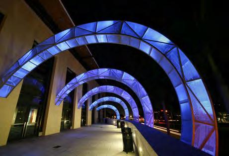
20 PUBLIC ART EXAMPLES 18 Mathis Avenue Streetscape Standards June 2017


21 PUBLIC ART OPPORTUNITIES LEGEND: Project Boundary Intersection There is a new trend in the City of Manassas to incorporate art around the historic downtown with such programs as the Banner Art project, Little Bits or Paint Manassas. Major Intersection Streets Historic District Mathis Ave. Reb Yank Dr. Portner Ave. Breeden Ave. Public art could be an integral part of the design and image of the public realm throughout the Study Area. It can be an effective tool for marking the entry points at key intersections, bus shelters, sidewalks, benches, bike racks, and bollards. Centreville Rd. Liberia Ave. Lion Amongst Men by Frank Albert Danville by Hunter Knight Cognitive Dissonance by Harry Mayer City of Manassas 19
 and green infrastructure are used to reduce dependence on conventional stormwater systems, thus reducing the cost to cleanse")
22 MANAGING STORMWATER Managing stormwater in the Study Area is an important consideration as municipalities are looking at ways to reduce their expenses. Stormwater best management practices such as Low-Impact Development (LID) and green infrastructure are used to reduce dependence on conventional stormwater systems, thus reducing the cost to cleanse and treat higher volumes of water. A variety of design standards are used to collect stormwater and can be adjusted as the new stormwater regulations as their associated credit programs are refined. Before deciding on specific stormwater strategies, soil testing should be completed to ensure proper drainage and performance. STORMWATER MANAGEMENT STRATEGIES All stormwater management strategies in the study will comply with applicable codes or standards including City of Manassas. The Virginia Stormwater Management Handbook should also be consulted. To maximize the amount of pervious surface in the study area consider using tree wells and buffer stormwater infiltration areas. Utilize the green space to limit the peak discharge by incorporating wet or dry detention basins, infiltration basins or trenches, and underground storage facilities. Infiltration areas are to be used in the Planting and Furnishing Zone only. Consider the use of green roofs on adjacent buildings to also reduce the volume of stormwater retention. RECHARGE AREAS: Stormwater recharge areas along the corridor could be placed in parks and buffers along the sidewalk. They are typically covered with grass or other vegetated material and topographically depressed so that stormwater flows easily into them. They are also constructed of porous backfill to let water pass through and recharge into the ground. In areas that drain poorly, such as clay soils, stormwater recharge areas can be further enhanced with underdrains. 20 Mathis Avenue Streetscape Standards June 2017

 strategy could be used between the tree wells along the curb allowing the tree roots to get more water, air, and nutrients.")

23 BIOSWALE TREE WELLS: POROUS PAVEMENT: SOIL CELLS: Open tree pits with curb cuts can be used for stormwater infiltration. It is important to use vegetation and trees species that can withstand wet soil for longer periods of time. Porous pavement allows water to percolate into the soils where it falls, reducing the total volume of stormwater. This low impact development (LID) strategy could be used between the tree wells along the curb allowing the tree roots to get more water, air, and nutrients. Note that permeable pavements need to meet the current regulations of the Americans with Disabilities Act. Soil cells are designed to serve as a bioretention swale under the sidewalk and give street trees more space for their roots to thrive. These plastic components provide structure and support to sidewalks above prohibiting soil compaction. These structures are also filled with an engineered soil mix to slow, clean and store water from average rainfall events on-site. City of Manassas 21


 are planted along the streets in the study area per.")


24 STREET TREE RECOMMENDATIONS TREE STANDARDS Planting Requirements: Throughout the study area, diverse tree species should be planted to create visual interest and avoid the devastating effects of drought or disease. It is recommended that no single tree family should exceed 30 percent, no single tree species should exceed 20 percent, and no single tree variety should exceed 10 percent. The diversity of species will undoubtedly be apparent along the corridor. However, to enforce visual consistency, it is recommended that the same tree species, or trees with similar forms, are planted per block, as represented in the Tree Planting Pattern diagram to the right. All tree selections needs to be approved by the City Arborist and the Design and Construction Standards Manual (DCSM). Tree Size: It is recommended that trees with a 4 1/2-inch caliper or greater (per the DCSM) are planted along the streets in the study area per. Street trees are generally large trees that have a canopy spread of 40 feet. These trees should be planted 2.5 feet to 3 feet from street curbs. When choosing sidewalk and side median trees, consider the form of the tree so that pruning can be minimal. Tree Form: Taking into consideration the shape of the tree at maturity is crucial. It is recommended that trees planted along sidewalks have a 7-foot clearance from the ground to the lower branches, while trees for vehicular areas have 14-foot clearance. If trees with a broader form or lower branching are chosen, frequent and radical pruning could be required. Soil Compaction: The majority of trees that are planted in the study area are between sidewalks and roadways which restrict root growth with compacted soils. In these urban planting conditions, soils provide fewer nutrients to the tree, drain poorly, and tend to be more acidic. Tree species should be chosen that can handle these conditions. Please refer to the following page to see how soil compaction can be avoided. TREE TYPES Pine and Fir Trees It is not recommended that evergreen trees be planted within the ROW because they could block sightlines and drivers views of pedestrians. Pine and fir trees can be used in other locations so long as they are planted at a minimum distance of 10 feet from the ROW. Accent Trees Accent trees are to be used in areas throughout the corridor, such as plazas, pocket parks, and entry courts, but not along the street curb. These trees are meant to provide diversity throughout the corridor with seasonal interest and height variation. Typically, they can be planted in tight spaces due to their shorter heights, smaller canopies and narrower trunk sizes compared to sidewalk and side median trees. Columnar: Suggested for narrow sites. Shade produced can be limited due to lack of wide crown. Oval: Preferred for street tree. Requires minimal pruning. Produces generous shade. Pyramidal: Generally requires pruning on lower branches. Round, Spreading: Produces ample shade. Generally requires pruning on lower branches. Vase: Preferred for street tree. Requires minimal pruning. 22 Mathis Avenue Streetscape Standards June 2017


 guards per se, but they do hinder access to tree wells (pits, parkways, bed space).")
25 TREE WELL OPTIONS PLANTED TREE WELLS: TREE GUARDS: TREE GRATES: A planted tree garden discourages people from compacting the soil by walking on top of the open tree well. Also, a well-maintained tree garden will enliven the public right of way in the study area. Choose plants that require little watering. Use small plants and bulbs, as large plants require large planting holes which damage tree roots. Also, plants with large root systems compete with the tree for water and nutrients. Do not add more soil to your tree well. Raising the soil level will harm the tree. Tree guards protect the tree well from soil compaction by closing off the tree area from pedestrians. Guards can come in many materials: decorative guards in metal (the traditional material), and in concrete and brick. The latter are not tree (trunk) guards per se, but they do hinder access to tree wells (pits, parkways, bed space). Some tree guards can be designed to serve multiple purposes such as benches and bicycle racks. Tree grates are used to cover the tree well to protect the tree from soil compaction while providing a flat, walkable surface that is flush with the sidewalk for pedestrians. There is some maintenance with tree grates. As a tree trunk expands, it can grow into the metal bars of the grate, so periodic cutting of the grate is needed. City of Manassas 23


26 VEGETATION Little Princess Spirea Yoshino Cherry Ginkgo Japanese Pagoda Weeping English Yew Green Vase Zelkova 24 Mathis Avenue Streetscape Standards June 2017
 3 Cal. Gleditsia triacanthos var. inermis Skyline Skyline Honey Locust 3 Cal.")


27 VEGETATION TREES BOTANICAL NAME COMMON NAME SIZE Ginkgo biloba Ginkgo (Male tree only) 3 Cal. Gleditsia triacanthos var. inermis Skyline Skyline Honey Locust 3 Cal. Magnolia virginiana Sweet Bay Magnolia 2 Cal. Ostrya virginiana Ironwood 3 Cal. Prunus x yedoenis Yoshino Cherry 2 Cal. Sophora japonica Japanese Pagoda 2 Cal. Zylkova serrata Green Vase Green Vase Zelkova 3 Cal. SHRUBS BOTANICAL NAME COMMON NAME SIZE Ironwood Gleditisia triacanthos, thornless Honey Locust Cephalotaxcus harringtonia Japanese plumyew 3 or 5 Gallon Ilex crenata Japanese Holly 3 or 5 Gallon Ilex glabra Inkberry 3 or 5 Gallon Spiraea japonica Little Princess Little Princess Spirea 3 or 5 Gallon Taxus baccata Repandens Weeping English Yew 3 or 5 Gallon Inkberry Seasonal Flowers: to be chosen by City of Manassas. Japanese Holly Sweet Bay Magnolia City of Manassas 25


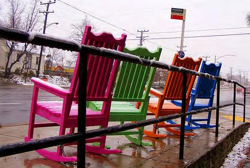
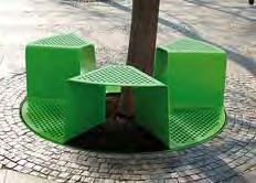
28 STREET FURNITURE OPTION: TRADITIONAL FURNITURE FAMILY Streetscape furniture can reinforce the street character as well as provide needed amenities for people visiting the commercial corridor. Streetscape elements can include:»» Lighting,»» Benches and seating,»» Bollards,»» Tree grates and tree guards,»» Street poles for traffic signs,»» Traffic signal structures,»» Sidewalk barriers to organize outdoor cafes and newspaper boxes, and»» Bike racks. Perenne Series Freesia Backed Flat Arm Steel, Horizontal Steel Slat Seating Manufacturer: Victor Stanley Model: FRE-20 Perenne Series Freesia Backless Flat Arm Steel, Horizontal Steel Slat Seating Manufacturer: Victor Stanley Model: FRE-23 Street furniture specified on this page may be substituted with the equivalent manufactures of the same quality. When not specified in this document refer to the DCSM for specific furniture specification. For street and pedestrian lighting, please coordinate with City Utility Department. Bicycle Parking Rack Manufacturer: Mad Rax Model: UX Rack (with Lean Bar) Bicycle Parking Rack End Cap Manufacturer: Mad Rax Model: U-24 with City Logo Trash Receptacle Manufacturer: Victor Stanley Model: RB Mathis Avenue Streetscape Standards June 2017
29 IMPLEMENTATION To achieve the goals of the Sector Plan and the vision for the Mathis Avenue Streetscape Standards, the City will need to take a multifaceted approach to implementation. This approach should include incentives for streetscaping through local grant programs, incorporating the standards as part of land use entitlement review, and investing in the corridor through maintenance and capital projects. LANDSCAPE AND FAÇADE GRANTS Manassas offers local façade and landscape improvement grant programs to encourage private investment in building and landscape enhancements along major thoroughfares and at gateway entrances to the City of Manassas. This program could be used to implement the Mathis Avenue Streetscape standards by actively marketing the program to targeted properties and prioritizing projects within the Mathis Avenue Revitalization District that advance the standards set here. DEVELOPMENT APPLICATIONS Land use and development applications offer another opportunity to implement these streetscape standards. When an applicant applies for a site plan, special use permit, or rezoning, projects should be evaluated against these standards and should provide streetscape improvements and/or ROW dedication as appropriate for the scale and impact of the project. To prevent streetscape features from being duplicated during redevelopment, staff should coordinate with property owners to have them install appropriate elements of the streetscape plan in place of the City s standard buffer planting requirements. Efforts to identify curb cuts that can be eliminated should also occur during development application review. The streetscape standards will be incorporated as an amendment to the City s Design and Construction Standards Manual. MAINTENANCE & CAPITAL PROJECTS Maintenance and capital projects will be needed to achieve the ideal streetscape vision outlined in this report. Where existing landscaping easements and center medians exist, the City should consider allocating maintenance improvement funding for additional landscaping, including deciduous and ornamental trees, shrubs, and particularly at key intersections and gateways. Ultimately, capital projects may be needed to implement the standards and could include property acquisition, intersection and travelway improvements, sidewalks, and landscaping. City of Manassas 27
30 CONSULTING PLANNER 2020 K Street, NW Washington, DC Neil Sullivan, Client Contact
VEHICULAR AND PEDESTRIAN CIRCULATION
 This perspective sketch communicates the intended character and quality of a proposed streetscape design. Locate benches near a major intersection where people tend to gather. Seating and lighting provide
COMPLETE GREEN STREET CHECKLIST
 COMPLETE GREEN STREET CHECKLIST This document was developed to dissect the structure of an urban street and explore opportunities to make our streets more complete while also integrating green street strategies.
The open space system should provide connective elements, relate to natural resources, and enhance the suburban character of the landscape..
 The open space system should provide connective elements, relate to natural resources, and enhance the suburban character of the landscape.. Mixed-use and infill development should maintain or enhance
Landscape and Streetscape Design 2.5
 Landscape and Streetscape Design 2.5 2.5.1 Goals 2.5.2 Planting 2.5.3 Sidewalks and Pavement 2.5.4 Furnishings 2.5.5 Walls 2.5.6 Lighting 2.5.7 Stormwater 2.5.8 Street Cross Sections 2.5 LANDSCAPE AND
GREENING THE BOULEVARD Master Plan Concepts for Venice Boulevard between Lincoln and Sawtelle
 GREENING THE BOULEVARD Katherine Spitz Associates Inc. 4212½ Glencoe Avenue Marina Del Rey, CA 90292 310 574 4460 Fax 574 4462 January 2008 Table of Contents Overview Proposed Design Improvements Illustration
Table of Contents. Elm Avenue Improvement Plan City of Waco, Texas. Introduction 1. Existing Context 1 Figure 1 2.
 Table of Contents Introduction 1 Existing Context 1 Figure 1 2 Plan Guidelines 3 Future Urban Form 4 The West-End 4 Main Street 6 The East-End 7 Figure 2 9 Public Improvement Recommendations 7 General
DRAFT. 10% Common Open Space
 % OF CHARLOTTE IS CATEGORIZED AS A. LAND USES : Placeholder map displaying location of Place Type GOALS: Accommodate XX% of future growth. Provide a concentration of primarily commercial and civic activity
Zoning Code Issues Prioritization
 City of Streetsboro The City of Streetsboro has begun the process of updating its Zoning Code. The new Zoning Code will be based on the recently adopted Comprehensive Plan, which establishes the overall
Community Design Plan
 Gardena General Plan 2006 Authority While the is not a required element of a General Plan, it is included because improving the community appearance and image is paramount to the overall quality of life
Transportation. Strategies for Action
 Transportation A major priority for the Overlake Neighborhood is to develop a multimodal transportation system. To achieve this system, a balance has to be found among travel, circulation and access needs;
appendix and street interface guidelines
 appendix five: building and street interface guidelines appendix 5 building and street interface guidelines BOULEVARDS Boulevards are generally characterized by higher levels of traffic movement at higher
Toronto Complete Streets Guidelines
 Toronto Complete Streets Guidelines 108 110 7.1 Green Infrastructure Design Principles 112 7.2 Context-Sensitive Green Streets 114 7.3 Key Green Street Elements Green infrastructure refers to natural and
A. Background Summary of Existing Challenges and Potential Possibilities. 1. Summary of Existing Assets and Potential Opportunities
 A. Background 1 A Main Street Master Plan Study was performed and completed in October of 2007. The study was initiated to review current land uses and development patterns along Main Street, from Parrish
Pedestrian and Bike Bridge LOGO
 6.2.2 Pedestrian and Bike Bridge The proposed pedestrian and bike crossing re-envisions the existing bridge at Pismo Creek on Cypress Street. The bridge is currently underutilized by vehicular through
BUILDING SCALE AND SETBACKS 5 ELEMENTS:... 5 FAÇADES (COMMERCIAL/RESIDENTIAL) 5
 5") VISION STATEMENT 3 UTILIZATION OF THE GUIDELINES 3 IMPLEMENTATION 3 PROCEDURES FOR DESIGN REVIEW 3 LAND USE AND ZONING 4 LAND USE 4 ELEMENTS:... 4 ZONING 4 ELEMENTS:... 4 BUILDING SCALE AND SETBACKS 5
VISION STATEMENT 3 UTILIZATION OF THE GUIDELINES 3 IMPLEMENTATION 3 PROCEDURES FOR DESIGN REVIEW 3 LAND USE AND ZONING 4 LAND USE 4 ELEMENTS:... 4 ZONING 4 ELEMENTS:... 4 BUILDING SCALE AND SETBACKS 5
PUBLIC RIGHT-OF-WAY IN THIS CHAPTER PUBLIC REALM
 PUBLIC RIGHT-OF-WAY This section provides design guidelines for improvements in the public right-of-way. The public right-of-way refers to streets, sidewalks, non-vehicular thoroughfares, parks and greenways
Establish a network of streetscaped vehicle and pedestrian routes that connect within and outside the Plan area.
 This Plan s urban design goals are to create an urban scale, walkable community with connections to transit, parks, and services and with amenities and facilities for residents and employees. The 1992
VISION AND GUIDING DESIGN PRINCIPLES
 pleasure point commercial corridor VISION AND GUIDING DESIGN PRINCIPLES Public Draft November 26, 2018 County of Santa Cruz with assistance from MIG CONTENTS PART I: INTRODUCTION AND VISION... 3 Community
BUSINESS DISTRICT DESIGN GUIDELINES
 Des Plaines, Illinois Prepared for the City of Des Plaines by: The Lakota Group Laurie Marston, AICP March 2005 Section 5: Streetscape Elements Business District Design Guidelines STREETSCAPE ELEMENTS
Streets Vision
 streets 86 2.9 Vision : The Most Prevalent and Important Public Spaces Fixed routes of human travel have served as corridors for commerce and places for human interaction from the earliest trails and foot
City of Burlington Downtown Street Design & Construction Standards
 City of Burlington Downtown Street Design & Construction Standards Adopted April 16, 2018 b City of Burlington Downtown Street Design Standards CITY OF BURLINGTON, VT The Great Streets Initiative is a
R STREET CORRIDOR NEIGHBORHOOD Site Plan and Design Review Supplemental Guidelines Checklist
 R STREET CORRIDOR NEIGHBORHOOD Site Plan and Design Review Supplemental Guidelines Checklist Applicant s Name: Project Address: Phone: Email: Applicant shall fill out the design guidelines checklist for
The Vision. Photo provided by The Minervini Group. 46 Vision, Objectives & Strategies
 Vision, Objectives & Strategies The is the public framework and guide for future development of the Grand Traverse Commons. The establishes public polices for infrastructure, the preservation of natural
Corridor Identity. Section 9. Introduction. Corridor Guiding Principles
 Corridor Identity An attractive and healthy community is a critical element of a quality place, and the design of quality places is a balance between environmental, economic, and social considerations.
Cit of Kitchener Ur 6 an Design Manual PARTA. Desi n for _--::
 Cit of Kitchener Ur 6 an Design Manual Date PARTA Year ) Desi n for k Nodes Corridors _--:: Section Page 01 of 12 2 INTRODUCTION Purpose & Application Nodes and Corridors have been identified as key intensification
Policies and Code Intent Sections Related to Town Center
 Policies and Code Intent Sections Related to Town Center The Town Center Vision is scattered throughout the Comprehensive Plan, development code and the 1994 Town Center Plan. What follows are sections
Wayfinding. North Gateway: Integrate a vertical gateway marker on the west side of Ward Street at the south corner of Vernon Street.
 3.3.6.2 Wayfinding Existing Conditions Wayfinding signage is important to direct visitors and tourists to different locations in the downtown. A significant part of the wayfinding signage in the downtown
Potential Green Infrastructure Strategies May 6, 2015 Workshop
 Potential Green Infrastructure Strategies May 6, 2015 Workshop Background The City of Cortland is developing the Tioughnioga Urban Headwaters Green Infrastructure Action Plan with funding from the National
Roanoke Rapids Streetscape Master Plan. City Council Presentation
 SCHEDULE: Stakeholder Meeting/Kick off November,2016 Master Planning Phase (November March 2017) Public Meeting #1 December 13, 2016 Review Meeting with Key Stakeholders Refine Concepts Based on Input
City of Dallas Complete Streets Program. SAME Infrastructure Forum February 2, 2018
 City of Dallas Complete Streets Program SAME Infrastructure Forum February 2, 2018 Complete Streets Design Manual Adopted by City Council January 27, 2016 JANUARY 27, 2016 2 What are Complete Streets?
DRAFT. October Wheaton. Design Guidelines
 October 2011 DRAFT Wheaton Design Guidelines 2 Draft - Design Guidelines - Wheaton Sector Plan Contents 04 Section 1: Introduction 06 Section 2: Context 08 Section 3: Design Guidelines 09 Goal 1: Create
4.9 Mendocino Avenue Corridor Plan Design Guidelines
 4.9 Mendocino Avenue Corridor Plan Design Guidelines The Mendocino Avenue Corridor Plan addresses the area between College Avenue and Steele Lane. Mendocino Avenue is a busy arterial that runs parallel
Figure Example of out door dining in the public right-of-way.
 Section 2 Core Area Goal 2.2.1 To maintain and enhance the character of existing streets in the Downtown Area. Character Figure 2.2.1 Example of out door dining in the public right-of-way. A. Provide street
Town Center (part of the Comprehensive Plan)
") Town Center (part of the Comprehensive Plan) Mercer Island Town Center Looking North (2014) In 1994, a year-long process culminated in a set of design guidelines and code requirements for the Town Center
Town Center (part of the Comprehensive Plan) Mercer Island Town Center Looking North (2014) In 1994, a year-long process culminated in a set of design guidelines and code requirements for the Town Center
MISSION STREETSCAPE PLAN. Neighborhood Commercial Streets handle continuous activity. Neighborhood Commercial STREET ROW: Main Design Treatments
 Neighborhood Commercial STREET ROW: 64-80 Main Design Treatments CORNER reduce crossing distance for pedestrians, create entrances to a residential area and slow cars down. help widen sidewalk allocating
Gas Stations ottawa.ca
 Urban Design Guidelines for Gas Stations ottawa.ca Ce document est disponible en français sur ottawa.ca. This document is available in French on ottawa.ca. Approved by City Council May 24, 2006 City of
CHAPTER 3. Design Standards for Business, Commercial, Industrial, Recreational and Institutional Uses
 CHAPTER 3 Design Standards for Business, Commercial, Section Number Title Ordinance Number Date of Ordinance 16-3-1 Applicability 2006-11 2008-04 07-01-08 16-3-2 Uniform Standards for Architectural Design
Lower Merion Commercial Districts Issues and Characteristics Handbook November 2013
 Lower Merion Commercial Districts Issues and Characteristics Handbook November 2013 DRAFT TOWNSHIP-WIDE VISION: To maintain and enhance commercial areas to complement the surrounding high-quality residential
CHAPTER 8. Mrs. Zimman s Class - Central Elementary
 SUSTAINABILITY CHAPTER 8 Mrs. Zimman s Class - Central Elementary 8.1 OVERVIEW Green infrastructure also known as low impact development (LID) and environmental or sustainable site design is an environmentally
COMMUNITY DESIGN. GOAL: Create livable and attractive communities. Intent
 COMMUNITY DESIGN Intent An attractive, well-designed County will attract quality development, instill civic pride, improve the visual character of the community, and create a strong, positive image for
EXISTING COMPREHENSIVE PLAN
 EXISTING COMPREHENSIVE PLAN Town Center Land Use Element: V. LAND USE POLICIES Town Center Mercer Island's business district vision as described in "Your Mercer Island Citizen-Designed Downtown" was an
Community Mixed Use Zone Districts (CMU)
") 18.28.500 Community Mixed Use Zone Districts (CMU) The Community Mixed Use Zone Districts (CMU) are intended to help implement the land use goals and strategies found in the Golden Vision 2030 values,
18.28.500 Community Mixed Use Zone Districts (CMU) The Community Mixed Use Zone Districts (CMU) are intended to help implement the land use goals and strategies found in the Golden Vision 2030 values,
Dogpatch/22nd Street Greening
 TEAM MEMBERS Prepared for: GreenTrustSF Central Waterfront www.gtsfcw.org Prepared by: Fletcher Studio San Francisco, CA www.fletcherstudio.com Landscape Architecture Urban Design Environmental Planning
DRAFT Northeast Quadrant of Kipling Avenue and Highway 7 DRAFT AUGUST 29, Goals Land Use. The goals of this Plan are to:
 AUGUST 29, 2017 12.15 Northeast Quadrant of Kipling Avenue and Highway 7 12.15.1 Goals 12.15.2 Land Use The goals of this Plan are to: 12.15.2.1 General Provisions: a) Ensure the development of a compact
Division VI Community Mixed Use (CMU) Architectural Guidelines and Standards
 Architectural Guidelines and Standards") Division VI 18.40.800 Community Mixed Use (CMU) Architectural Guidelines and Standards 18.40.810 Guidelines The goals of the Comprehensive Plan include a focus on pedestrian safety, amenities and aesthetics
Division VI 18.40.800 Community Mixed Use (CMU) Architectural Guidelines and Standards 18.40.810 Guidelines The goals of the Comprehensive Plan include a focus on pedestrian safety, amenities and aesthetics
11.0. Design Manual: Sustainable Initiatives. Chapel Hill Streetscape and Lighting Master Plan mikyoung kim design all rights reserved.
 11.0 Design Manual: Sustainable Initiatives 2008 mikyoung kim design all rights reserved. Chapel Hill Streetscape and Lighting Master Plan 109 110 Chapel Hill Streetscape and Lighting Master Plan DESIGN
Silverdale Regional Center
 Silverdale Regional Center Vision for Silverdale Regional Center The Silverdale Regional Center Plan (Plan) will guide the evolution of the Silverdale Regional Center from a collection of strip malls and
The Baileys Planning District portion of the Comprehensive Plan contains site design recommendations for both the Baileys Crossroads Community
 The Baileys Planning District portion of the Comprehensive Plan contains site design recommendations for both the Baileys Crossroads Community Business Center and the Seven Corners Community Business Center.
ARLINGTON COUNTY, VIRGINIA
 ARLINGTON COUNTY, VIRGINIA County Board Agenda Item Meeting October 15, 2005 DATE: September 28, 2005 SUBJECT: Request to Advertise the adoption of the 2005 Clarendon Sector Plan C. M. RECOMMENDATION:
Preliminary Recommendations Tk Takoma/Langley Crossroads Sector Plan
 Preliminary Recommendations Tk Takoma/Langley Crossroads Sector Plan Vision is to achieve a Transit Oriented, pedestrian friendly Community that Celebrates and builds upon the cultural Diversity of the
Chapter 14 Streetscape Improvements
 This chapter presents streetscape design concepts for key streets and gateways in the Downtown Specific Plan area. This chapter is organized as follows: 14 Streetscape Improvements 14.1 Streetscape Treatments
Highland Village Green Design Guidelines
 Highland Village Green Design Guidelines Publishing Information Title Highland Village Green Design Guidelins Author The City of Calgary Status DRAFT - Proposed document subject to changes Additional Copies
Technical Advisory Committee
 CULVER DOWNTOWN STREETSCAPE PLAN STREETSCAPE IDEAS REPORT 01.08.2008 Project Team Matt Crall, Transportation and Growth Management Quick Response Program Donna McCormack, City of Culver Darrell Newton,
New Partners for Smart Growth Conference February 5, 2010
 Dan Stroh, Planning Director City of Bellevue Planning and Community Development Bellevue, WA New Partners for Smart Growth Conference February 5, 2010 Summary of Project Long-range plan update for Bel-Red
FRUITVALE TRANSIT VILLAGE (Phase 2) Residential Project
 Residential Project") FRUITVALE TRANSIT VILLAGE (Phase 2) Residential Project DEVELOPER: SIGNATURE PROPERTIES ARCHITECT: HKIT ARCHITECTS April 23, 2010 TABLE OF CONTENTS 3 Vision 4 Description of Site 5 Guiding Concepts 6
FRUITVALE TRANSIT VILLAGE (Phase 2) Residential Project DEVELOPER: SIGNATURE PROPERTIES ARCHITECT: HKIT ARCHITECTS April 23, 2010 TABLE OF CONTENTS 3 Vision 4 Description of Site 5 Guiding Concepts 6
SPRINGHILL LAKE TRANSIT VILLAGE
 Greenbelt Metro Area Sector Plan - Subarea Design Policies and Guidelines - Springhill Lake Transit Village 113 SPRINGHILL LAKE TRANSIT VILLAGE Residential Neighborhood and Village Center CONCEPT Springhill
SOUTH UNIVERSITY Street Design Alternatives in Progress
 1 Alternatives in Progress 2016.01.20 Meeting Agenda 2 1. Progress & Schedule 2. Utilizing the Street Design Manual 3. Site Characteristics and Input Received 4. Street Geometry What can we accomplish
Study Area. Capitol Way. Greening America s Capitals 11/13/2014. A Greening America s Capitals Project
 Olympia, WA: Greening Capitol Way Supporting Communities move towards sustainability is a priority for the federal government. A Greening America s Capitals Project Office of Sustainable Communities U.S.
Maplewood Avenue Downtown Complete Street Project
 Maplewood Avenue Downtown Complete Street Project Second Public Meeting January 24, 2018 Welcome and Introduction of Project Team City Planning and Public Works Staff City of Portsmouth Juliet Walker Planning
SUBCHAPTER 4-B GUIDELINES FOR THE B-3 COMMERCIAL CHARACTER AREA
 1 SUBCHAPTER 4-B GUIDELINES FOR THE B-3 COMMERCIAL CHARACTER AREA Downtown Bozeman should be the location of buildings of greatest height and intensity in the community. The following guidelines apply
Jewel. Platte. of the. Plattsmouth Main Street Landscape Architecture by HDR
 Jewel of the Platte Plattsmouth Main Street Landscape Architecture by HDR Plattsmouth, Nebraska is a historic community of 6,500 residents located along the west bank of the Missouri River, just south
Executive Summary. NY 7 / NY 2 Corridor
 Executive Summary NY 7 / NY 2 Corridor Transportation and Land Use Study December 2005 Prepared for: Town of Colonie Capital District Transportation Committee Prepared by: Introduction: Land use decisions
PIKE PINE RENAISSANCE: ACT ONE. October 19, 2017
 PIKE PINE RENAISSANCE: ACT ONE October 19, 2017 WATERFRONT SEATTLE PROGRAM PROJECT INTRODUCTION Pike and Pine streets, between First and Melrose avenues Pedestrian and streetscape improvements Budget:
Design Guidelines for the Route 30 Corridor Master Plan: Subdivision and Land Development Elements
 Design Guidelines for the Route 30 Corridor Master Plan: Subdivision and Land Development Elements East Whiteland Township- Chester County, PA Prepared by: Draft: May 7, 2018 Design Guidelines for the
SFMTA PHELAN LOOP AND PUBLIC PLAZA PHELAN OCEAN AVENUE
 SFMTA Municipal Transportation Agency Image: a bus in front of the Palace of the Legion of honor SFMTA PHELAN LOOP AND PUBLIC PLAZA PHELAN AVENUE @ OCEAN AVENUE Community Meeting May 23, 2012 San Francisco,
FREEWAY/TOURIST DISTRICT
 FREEWAY/TOURIST DISTRICT DESIGN STANDARDS FOR THE CITY OF MOUNTLAKE TERRACE March, 2014 MOUNTLAKE TERRACE FREEWAY/TOURIST DESIGN STANDARDS March, 2014 1 TABLE OF CONTENTS Introduction...1 Design Site Design
Cleveland Park Streetscape and Drainage Improvement Project 1
 Cleveland Park Streetscape and Drainage Improvement Project 1 Urban Context Washington, D.C. Connecticut Avenue Cleveland Park Streetscape and Drainage Improvement Project 2 Neighborhood Context Contributing
Figure 3-1: Public Realm Plan
 3 Public Realm Figure 3-1: Public Realm Plan 3.1 Public Realm Concept The public realm concept for the Little Mountain site integrates a clear and accessible movement network with public spaces for social
STREETSCAPE IMPROVEMENTS - RECOMMENDATIONS
 STREETSCAPE IMPROVEMENTS - RECOMMENDATIONS Figure 4.3.1- A map of all of the recommended streetscape improvements. The key component of downtown s public realm, apart from its public spaces, is its street
Urban Design Manual PLANNING AROUND RAPID TRANSIT STATIONS (PARTS) Introduction. Station Study Areas
 Introduction. Station Study Areas") 111111 PLANNING AROUND RAPID TRANSIT STATIONS (PARTS) Introduction The ION rapid transit system will link Waterloo, Kitchener and Cambridge through a central transit corridor (CTC). There are a number
111111 PLANNING AROUND RAPID TRANSIT STATIONS (PARTS) Introduction The ION rapid transit system will link Waterloo, Kitchener and Cambridge through a central transit corridor (CTC). There are a number
Main Street Reconstruction From Ninth Line to Stouffer Street. Town of Whitchurch-Stouffville. Public Information Centre
 Main Street Reconstruction From Ninth Line to Stouffer Street Town of Whitchurch-Stouffville Public Information Centre November 23, 2016 4:30 to 6:00 pm & 7:00 to 8:00 pm 6240 Main Street, Stouffville
Lambeth Main Street Streetscape Improvements
 Lambeth Main Street Streetscape Improvements Open House October 5th, 2017 Agenda 1. Introduction 2. Project Background 3. Context 4. Project Objectives 5. Design Principles & Approach 6. Streetscape Design
East Bayshore Road Neighbourhood
 East Bayshore Road Neighbourhood Northridge Property Management Urban Design Brief 3195 East Bayshore Road City of Owen Sound January 2016 East Bayshore Road Neighbourhood Northridge Property Management
Dallas Complete Streets Initiative and Design Manual. City Council Briefing December 2, 2015
 Dallas Complete Streets Initiative and Design Manual City Council Briefing December 2, 2015 1 Purpose Update the Dallas City Council on the Draft Complete Streets Design Manual Discuss Upcoming Work Plan
Civic Center District
 Civic Center District The Civic Center district is the civic and social heart of Warrenville, containing such public buildings as the City Hall, Warrenville Public Library, Police Station, Park District
HEALTH SCIENCES BUILDING REDEVELOPMENT PROJECT
 INTRODUCTION In recent years, the University of Cincinnati (University) has demonstrated a commitment to identifying and implementing sustainable goals and objectives throughout University s Uptown Campuses.
lot flankage Y street 16m 6m landscape strip for large site 3m landscape strip for small medium site
 Commercial General Commercial Objectives Create developments compatible with adjacent land uses in scale, function and character Define a consistent and attractive street edge with quality landscaping,
CAMPUS PLANNING COMMITTEE STAFF REPORT SAMARITAN SPORTS MEDICINE INSTITUTE AT OSU 10/21/2013
 Office of Capital Planning and Development; 130 Oak Creek Building; Corvallis, Oregon 97331-2001 CPC STAFF REPORT: SAMARITAN SPORTS MEDICINE INSTITUTE AT OSU CAMPUS PLANNING COMMITTEE STAFF REPORT SAMARITAN
The Project. In 2013, construction was completed between 100 Street and 102 Street.
 The Project Jasper Avenue New Vision (JANV) is a major catalyst project identified in the Capital City Downtown Plan (2010) between 92 Street and 109 Street, including the streets half a block north and
URBAN DESIGN BRIEF. 2136&2148 Trafalgar Road. Town of Oakville
 URBAN DESIGN BRIEF 2136&2148 Trafalgar Road Town of Oakville Prepared By: METROPOLITAN CONSULTING INC For 2500674 Ontario Inc November 2016 TABLE OF CONTENTS Page No. 1.0 Introduction/Description of Subject
SDOT DPD. SDOT Director s Rule DPD Director s Rule DCLU DR SED DR of 7 CITY OF SEATTLE
 SDOT SDOT Director s Rule 2-07 DPD Applicant: CITY OF SEATTLE Page 1 of 7 Supersedes: DCLU DR 11-93 SED DR 93-4 Seattle Department of Transportation (SDOT) Department of Planning and Development (DPD)
3.0 master plan concept
 3.0 master plan concept 3.1 introduction The purpose of the Huron Church Road Master Plan Concept is to provide an overview of the Master Plan design process, identify preliminary streetscape installations
Derry Green Corporate Business Park
 Town of Milton Derry Green Corporate Business Park Urban Design Guidelines BMI/Pace - June 2010 Draft 3 Prepared by: Brook McIlroy Planning + Urban Design / Pace Architects Suite 300-51 Camden Street Toronto,
Chapter PEDESTRIAN COMMERCIAL (PC) ZONING DISTRICT
 ZONING DISTRICT") Chapter 11-17 PEDESTRIAN COMMERCIAL (PC) ZONING DISTRICT Sections: 11-17-01 GENERAL PURPOSE 11-17-02 PERMITTED BUILDING TYPES 11-17-03 USES PERMITTED WITH DESIGN REVIEW 11-17-04 USES PERMITTED BY CONDITIONAL
Chapter 11-17 PEDESTRIAN COMMERCIAL (PC) ZONING DISTRICT Sections: 11-17-01 GENERAL PURPOSE 11-17-02 PERMITTED BUILDING TYPES 11-17-03 USES PERMITTED WITH DESIGN REVIEW 11-17-04 USES PERMITTED BY CONDITIONAL
FROM DUPONT CIRCLE NORTH TO CALIFORNIA STREET, NW. Welcome!
 FROM DUPONT CIRCLE NORTH TO CALIFORNIA STREET, NW Welcome! Meeting Agenda 6:00 PM Open House 6:30 PM Presentation 7:00 PM Open House / Q&A at the Boards Project Design Team Connecticut Avenue, NW Project
Seneca Meadows. Block 4 Locate office, technology, and medical development adjacent to I Screen views of garage structures from I-270.
 Seneca Meadows Seneca Meadows has an industrial park in its southern end and a mixed-use employment area planned for the north end. The district benefits from extensive I-270 visibility, stream valley
THE CIVIC DISTRICT DEVELOPMENT OPPORTUNITIES
 1 THE CIVIC DISTRICT DEVELOPMENT OPPORTUNITIES The Civic District is the physical and emotional heart of the downtown. It is also a major gateway into the central core, establishing the image and identity
AIRPORT BUSINESS PARK
 PIER MAC PETROLEUM INSTALLATION LTD. AIRPORT BUSINESS PARK DEVELOPMENT APPLICATIONS March 2003 4.1 Airport Business Park Development Permit Area 4.1.1 Justification/Design Concept The design concept envisioned
Conceptual Design. Main Street Enhancement and Extension Project. Bothell, Washington. June 11, 2009
 Conceptual Design Main Street Enhancement and Extension Project Bothell, Washington June 11, 2009 Berger/ABAM Engineers and Cascade Design Collaborative, Inc For Main Street Bothell to succeed it must
PROTECT AND PROMOTE QUALITY OF LIFE AND LIVABILITY FOR THE CITIZENS OF GAINESVILLE THROUGH QUALITY URBAN DESIGN.
 Goals, & Urban Design Element PROTECT AND PROMOTE QUALITY OF LIFE AND LIVABILITY FOR THE CITIZENS OF GAINESVILLE THROUGH QUALITY URBAN DESIGN. GOAL 1 By 2003, the City shall adopt urban design standards
Design Guidelines for PRINCESS ANNE COMMONS
 Design Guidelines for PRINCESS ANNE COMMONS January 25, 2002 To create a unique and identifiable place with attractive, exciting, efficient and safe components to enhance the consistency of the built environment
section five BEAUTIFICATION PLAN
 section five BEAUTIFICATION PLAN BEAUTIFICATION PLAN Section Five Beautification Plan The goal of the Beautification Plan is to improve the Route 8-Sunnyland Corridor in terms of aesthetics and to create
Today Land & People. Northeast Nampa Gateway District. Employment. Land Use Characteristics. Demographics. Current Zoning
 Today Land & People Employment Major employers include Saint Alphonsus, the College of Western Idaho, the Auto Mall, Sorrento Lactalis and Walmart. 3,004 jobs in 2010 (COMPASS-CIM 2040 TAZ data) 4,345
V. Gateways GATEWAYS / V-1
 V. GATEWAYS / V-1 Many of Chesapeake s gateways are located on highways and call for bold and attractive designs that motorists can understand, appreciate, and enjoy. can also take the form of natural
Street Flooding Mitigation Plan KYOVA Interstate Planning Commission. Presented to AMPO National Conference October 18, 2017
 Street Flooding Mitigation Plan KYOVA Interstate Planning Commission Presented to AMPO National Conference October 18, 2017 Saleem Salameh, Ph.D., P.E., M.ASCE Chet Parsons, AICP CTP Agenda: Background
urban design Introduction
 ACHIEVE SP RI NGF I ELD.3 Introduction Urban Design Areas Design Areas are areas within Springfield that have a unique and recognizable character that is different from other areas in the community. The
Issues Requiring Future Study
 Issues Requiring Future Study Transportation planning is an ongoing process that tends to identify new issues as it finds solutions for others. Some issues are so complex that a solution to one problem
3. VISION AND GOALS. Vision Statement. Goals, Objectives and Policies
 Vision Statement Queen Creek s interconnected network of parks, trails, open spaces and recreation opportunities provide safe and diverse activities and programs that sustain its unique, small town, equestrian
WEST LOOP DESIGN GUIDELINES CHECKLIST
 WEST LOOP DESIGN GUIDELINES CHECKLIST Section 1.0 General Strategies 1.1 DESIGN EXCELLENCE: ENCOURAGE HIGH QUALITY AND INNOVATIVE DESIGN OF NEW BUILDINGS WITHIN THE WEST LOOP WITHOUT BEING PRESCRIPTIVE
Cobb County Design Guidelines Mableton Parkway & Veterans Memorial Highway Community Design Workshop January 12, 2017
 Community Design Workshop January 12, 2017 Agenda Opening Remarks / Introductions Scope of Work Existing Conditions Key Issues / Opportunities VPS Summary Draft Vision & Goal Statement Implementation Concepts