THE CORPORATION OF THE CITY OF VERNON BYLAW NUMBER A bylaw to amend the City of Vernon s Plan Vernon Bylaw Number 5151
|
|
|
- Abner Shepherd
- 6 years ago
- Views:
Transcription
1 THE CORPORATION OF THE CITY OF VERNON BYLAW NUMBER 5455 A bylaw to amend the City of Vernon s Plan Vernon Bylaw Number 5151 WHEREAS the Council of The Corporation of the City of Vernon has determined to amend the "Plan Vernon Bylaw Number 5151, 2008"; AND WHEREAS all persons who might be affected by this amending bylaw have, before the passage thereof, been afforded an opportunity to be heard on the matters herein before the said Council, in accordance with the provisions of Section 890 of the Local Government Act, and all amendments thereto; NOW THEREFORE the Council of The Corporation of the City of Vernon, in open meeting assembled, enacts as follows: 1. This bylaw may be cited as Plan Vernon (Foothills Neighbourhood Plan) Amendment Bylaw Number 5455, That Schedule "A" of Plan Vernon Bylaw Number 5151 is hereby amended as follows: A. Amending the 'Supplementary Plans, Policies and Strategies' by Adding new item 12 - Foothills Neighbourhood Plan as shown on Schedule A attached hereto and forming part of this bylaw. B. Replacing 'Map 1 Land Use Plan', with new Map 1 as shown on Schedule "B" attached hereto and forming part of this bylaw. C. Replacing 'Map 13 Adopted Neighbourhood Plan Areas' with new Map 13, as shown on Schedule "C" attached hereto and forming part of this bylaw.
2 PAGE 2 BYLAW NUMBER Plan Vernon Bylaw Number 5151 is hereby ratified and confirmed in every other respect. READ A FIRST TIME this 12th day of August, READ A SECOND TIME this 12th day of August, PUBLIC HEARING held this 23rd day of September, READ A THIRD TIME, AS AMENDED THIS 23rd day of September, ADOPTED this 15th day of October, Mayor Corporate Officer
3 SCHEDULE 'A' Attached to and forming Part of Bylaw 5455 as Plan Vernon (Foothills Neighbourhood Plan) Amendment Bylaw Number 5455, 2013 Supplementary Plans, Policies and Strategies The following form part of the Official Community Plan 2008: 1. Landscape Buffer Design Criteria along Eastside Hwy 97 north from 45 Avenue to Swan Lake Overpass 2. City Centre Neighbourhood Plan 3. Bella Vista West Neighbourhood Plan, July Predator Ridge Neighbourhood Plan, October North Vernon Neighbourhood Plan 6. Waterfront Neighbourhood Centre Plan, January Okanagan Hills Neighbourhood Plan 8. East Bella Vista Highlands Neighbourhood Plan 9. Transportation Plan Environmental Management Areas Strategy 11. Hillside Guidelines 12. Foothills Neighbourhood Plan, August 2013
4 Foothills Neighbourhood Plan September 2013
5 Table of Contents 1.0 Plan Overview Neighbourhood Context Public Consultation Neighbourhood Plan Vision and Goals Residential Neighbourhood Centre (Mixed Use Medium Density Commercial and Residential) Parks and Open Space Rural and Agricultural Transportation Utilities... 32

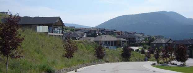
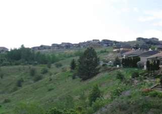
6 1.0 Plan Overview The Foothills is among Vernon's fastest growing neighbourhoods and is positioned for more growth and development as demand for living in the area increases. With this anticipated growth comes a number of opportunities to make the neighbourhood an even more desirable place to live. There are also a number of challenges faced in the neighbourhood. Steep hillsides, which are among the defining features of the area, are difficult to build on and contribute to the beauty of the neighbourhood. There is an identified need in the area for more parks, as well as parks that are designed to meet the needs of local residents. The provision and maintenance of streets and utilities in hillside areas is expensive. Many of these streets do not feel safe to walk or bicycle along. A clear direction through the neighbourhood plan can address these and other issues. Neighbourhood plans are detailed plans developed by the City that supplement the Official Community Plan (OCP) and provide additional direction for new growth and development in a specified area. A neighbourhood plan addresses issues specifically related to that neighbourhood and provides direction for decision making regarding land use and infrastructure. Through this neighbourhood plan, ways to improve the neighbourhood can be identified with a clear framework for future development. The primary features of this plan are: The designation of areas for low and medium density hillside residential development. The designation of a neighbourhood centre area that includes small scale commercial uses mixed with multifamily development and public space. A transportation network that facilitates walking, cycling and transit use. The identification of preferred park locations, including a park at the top of the hill. A trail network that connects parks and other key destinations in the neighbourhood. The protection of sensitive ecosystems and ravines. The protection of steep hillsides and views. The policies in this plan are designed to provide clear direction for future development while maintaining a degree of flexibility. It is likely that during the timeframe for build out of the neighbourhood, market conditions are likely to change. With this in mind, some land use designations and policies are intentionally broad, with the intent being that more detail will be provided as a property moves closer to development through rezoning and/or subdivision.
 in size.")
7 2.0 Neighbourhood Context 2.1 Neighbourhood Overview The Foothills neighbourhood is located at the northeastern edge of Vernon, off Silver Star Road. It is approximately 800 acres (323.6 hectares) in size. The neighbourhood is surrounded on all sides by Electoral Area C in the Regional District of North Okanagan, except for the portion of Silver Star Road between the neighbourhood and the rest of the city, which falls under City of Vernon jurisdiction (Map 1). The Foothills neighbourhood is characterized by hilly grasslands and forested areas held in ten large properties in the northern portion of the plan area, a growing residential neighbourhood in the southern portion, and a single large property identified as a neighbourhood centre across Silver Star Road at the very southern edge of the plan area (Map 2). The neighbourhood is known for its beautiful views of the city, the valley, the mountains and Kalamalka, Okanagan and Swan Lakes. Prior to residential development, the area was used primarily for ranching purposes. The Grey Canal wound along the western and southern edge of the neighbourhood, providing irrigation to agricultural lands downhill. The Foothills Neighbourhood Plan area is within Neighbourhood Plan Area 2 (NPA-2) and Development District #3 Hillside Residential and Agricultural District as identified in the Official Community Plan. Because much of the land in the neighbourhood plan area is sloped and contains several highly sensitive ecosystems, both the Hillside Guidelines and the Environmental Management Areas Strategy apply and will play a large role in directing future development in this area. Map #1: Foothills Neighbourhood Plan Area
8 2.2 Physical Characteristics The hillsides of the neighbourhood frame where development has and will take place in the future. The topography in the area consists primarily of slopes with south and west aspects while the northwest corner of the neighbourhood is relatively flat. Many of the slopes exceed 30% grade, particularly those surrounding the top of the hill and along a large ridge running from the northern boundary of the neighbourhood plan area to the southwest corner (see Map 3). One of the most distinguishing features of the plan area is a forested area at the top the hill, which is highly visible from most areas in the neighbourhood and from nearly everywhere in the city. 2.3 Development History Residential development in the Foothills neighbourhood began in the late 1980s with the first residential lots being created in The early 1990s saw single family housing development continue, along with the first multifamily development in the southeast corner of the plan area. Residential development started occurring at a much faster rate after 2000, particularly between 2005 and 2009 (Map 4). In 2008, approximately 212 acres of private land was annexed into the city. These lands form much of the area north of the existing developed neighbourhood. 2.4 Existing Neighbourhood Characteristics Figure 1: Distribution of Age Groups in Foothills and Vernon The population of the Foothills neighbourhood has risen greatly in the last few years. The population at the 2011 Census was 1,361, compared to 831 only five years earlier, marking a 64% increase over that time period. This coincides with a period of rapid development in the neighbourhood and is significantly higher than the 6% increase in Vernon s population as a whole during the same period. There are currently 521 homes in the Foothills neighbourhood, of which 478 are single family and 43 are multifamily. 25% 20% 15% 10% 5% 0% to to to to to to to 99 Foothills Vernon The demographics of the neighbourhood differ from the rest of Vernon. The Foothills is home to a younger population, with an average age of 40.9 compared to 44.2 for all of Vernon. 20% of its residents are between the ages of 0 to 15 years, which is higher than the rest of Vernon, with 14% in this age range. Foothills also has a large population aged 35 to 64. Teenagers, young adults and seniors are underrepresented, as illustrated in Figures 1 and 2. Figure 2: Average Age in Foothills, Vernon and BC Foothills Vernon British Columbia

9 Map #2: Air Photo of Foothills Neighbourhood Plan Area

10 Map #3: Slope Analysis and Ecologically Sensitive Areas

11 Map #4: Subdivision History


12 3.0 Public Consultation Consultation with residents took place in a number of different sessions to allow as many people to participate as possible. The feedback from residents contributed greatly towards a vision for the neighbourhood and the identification of goals to guide policy. The following sessions were held to gain input: Foothills Community Association Meeting A meeting was held with the Foothills Community Association on April 19, 2011 to discuss the purpose of a neighbourhood plan and how the process could proceed. Approximately 50 people attended this session. Community Visioning Session A Community Visioning Session was held at BX Elementary School on June 22, The purpose of the session was to gauge how Vernon residents felt about issues like housing, transportation, parks, and commercial development (in the neighbourhood centre) as they related to the Foothills neighbourhood. Participants were asked what they like and what they would change about their neighbourhood. Over 100 people attended this session and provided feedback. Kitchen Table Sessions In October 2012, a series of smaller sessions were held at the homes of Foothills residents. These "kitchen table" sessions were an opportunity for smaller groups of residents to speak with staff about specific topics in the neighbourhood. Residents who volunteered to host a session at their home selected one or two topics to discuss and invited their neighbours to the session. The size of the groups ranged from 4 to 18, with between 60 and 70 people participating in 7 sessions.

13 Community Open Houses Community Open Houses was held at B.X. Elementary School on November 3, 2012 and April 27, 2013 to present a draft land use concept, a proposed transportation network and draft policies and to gain further input into the draft plan. Approximately 120 people attended the 2012 open house and 70 attended in Common themes emerged from the feedback received at these sessions: Residents like the quiet, natural setting that the neighbourhood offers. There is a strong desire to see the Foothills remain as a primarily single family neighbourhood, but multifamily development is supported if it is in the right place. There is strong support for the top of the hill to be designated as a park. There are concerns about traffic and traffic safety, particularly along Silver Star Road and collector roads. Residents would like more opportunities to walk or ride their bikes in the neighbourhood. Preservation of wildlife corridors and natural areas is important. There is support for a small scale commercial node that is easily accessed on foot or by transit. This node should include a public space component and provide pedestrian access to the Grey Canal Trail. Public transit is supported, particularly for seniors and youth. There is very high support for a multi-use pathway for pedestrians and cyclists to BX Elementary School and to connect to the rest of the city. There is demand for more trails and greater connectivity in trail networks within the neighbourhood. There is support for trails at the top of the ravines, as long as impacts on privacy can be minimized. Owners of many of the large properties in the north end of the neighbourhood plan area were also consulted for input into the neighbourhood plan. Specifically, discussions centered around land use, transportation networks, development phasing and utility infrastructure provision.

14 4.0 Neighbourhood Plan Vision and Goals The community consultation revealed a number of themes related to how residents wanted the neighbourhood to develop. Using these themes, the following vision has been developed: In the future, the Foothills neighbourhood is: A primarily residential neighbourhood with excellent access to the surrounding natural areas that define it. A place where seniors can continue living in the neighbourhood, even as their ability to travel and maintain large yards is reduced. A neighbourhood that accommodates the needs of youth, including access to amenities in parks and places to meet their friends. A place where residents are able to choose how they get around their neighbourhood, and feel that those choices are safe and convenient. A place where day-to-day shopping services are provided close to home, within walking distance for many residents. Much of this vision can be achieved by new development. However, the neighbourhood plan also addresses ways that improvements can be made to established areas in the Foothills. 4.1 Neighbourhood Plan Goals To support this vision, the Foothills Neighbourhood Plan has the following goals: Provide the right housing in the right place. To be economically viable, residential development in the Foothills must meet the housing needs of current and future Vernon residents, so it is important to ensure that the housing types provided are a good match for the people moving into the neighbourhood. Much of the area would be characterized by low density single and two family housing, but clusters of four-plexes and rowhouses near major roads provide housing variety while encouraging density along these routes, necessary for services like transit to be provided. Low rise apartments incorporated into the neighbourhood centre should also be encouraged to provide a local population to help support commercial services in the area.
15 Provide appropriate, sustainable infrastructure. New infrastructure should be designed to suit the needs of children, youth, seniors and adults. Roads should be sized appropriately to discourage speeding and to provide safe and pleasant ways to travel for pedestrians, cyclists and motorists. Sidewalk and trail networks should take people places they want to go. The introduction of transit service would provide greater mobility for residents who do not always have access to an automobile or would like to use transit as an option to get around. New infrastructure, including roads, water and sewer, however, all come with a construction and maintenance cost. This neighbourhood plan aims to identify new infrastructure for future development in a way that reduces these costs, while maximizing the use of infrastructure that is already in place. Provide more parks, public spaces and trails. The neighbourhood plan aims to identify more parks and public spaces as new development proceeds. Improvements to the pedestrian networks, including trails, in new and existing developments are also proposed. Parks, public spaces and trails should promote a safe, friendly community, meet the needs of a wide range of residents and celebrate the unique characteristics of the area. Create a neighbourhood centre that fits the Foothills. The neighbourhood centre is intended to become a place where residents can meet many of their day-today shopping needs close to home, socialize and access other community amenities, such as the Grey Canal Trail. Commercial uses should be small scale and integrated with residential development to maintain the character of the existing neighbourhood. The creation of a neighbourhood centre area will provide day-to-day services for residents in the area that are accessible by walking, cycling and transit, thereby reducing the need for longer trips. Respect ecologically sensitive areas and hillsides. The Foothills neighbourhood is home to a variety of ecosystems and landscape features. These natural areas are highly valued by residents and have been identified as a major draw to the neighbourhood. The top of the hill, the views and the hillsides in the area are distinct features which have been identified by community members as being a significant part of the neighbourhood identity. These features have also been identified by residents living in other neighbourhoods as important recreation areas, which offer excellent views. As development proceeds, the protection of sensitive ecosystems, significant features and highly sloped areas will help to maintain the highly valued views, recreation access, remote feel and identifiable neighbourhood features of the Foothills.


16 5.0 Residential Existing residential development in the Foothills consists primarily of single family homes, with semi-detached and tri-plex housing in some areas. There are also a number of properties that are zoned for multifamily housing around the neighbourhood, but have yet to see such development take place. In addition, a large portion of the property north of Blackcomb Way is zoned for low density hillside residential development, which allows for single family housing, semi-detached housing and duplexes. Secondary suites are permitted in the neighbourhood in single detached housing only, which is consistent with policies related to secondary suites in the rest of the city. Residential development in the future would continue to be predominantly single family homes, but would include a larger mix of semidetached, duplex, tri-plex, four-plex and row housing located in designated areas. Future development would continue to support the quiet residential character of the Foothills neighbourhood, while offering greater flexibility in land use and design to accommodate anticipated demand over the next few decades. The slopes in the Foothills neighbourhood lend themselves to the creation of distinct areas for new development, separated by rural / agricultural uses (see Map 5). Each area is intended to have a mix of housing types, with ground oriented multi-family housing being clustered in specific areas. Development will proceed based on market conditions, and will be phased according to cost effective infrastructure provision. Development of large parcels of land not adjacent to existing development and services is discouraged, but may be possible should development be able to cover the costs of infrastructure provision. 5.1 Policy Objectives The policies of this section are derived from the feedback through the community consultation and designed to meet the following objectives: Provide a variety of housing types to meet the changing housing needs of Vernon residents.
17 Provide for ground oriented multifamily housing types where site conditions and location are able to maximize the utilization of infrastructure and services. Protect views of and from the Foothills neighbourhood. Encourage development that is consistent with the built form and characteristics of the surrounding neighbourhood. Promote development that is consistent with the intent of the City of Vernon Hillside Guidelines. Locate development to protect ecosystems, avoid ravines and enhance opportunities for enjoyment of natural areas and avoidance of wildlife corridors. 5.2 Supporting Policies Residential development in the Foothills should continue to have a similar feel to neighbouring development while also allowing for flexibility in design and use to meet future demand. Development must conform to policies outlined in Vernon's Official Community Plan to address issues related to hillside development, environmentally sensitive areas and fire interface. 1. All properties designated as Residential - Low Density have a maximum density of 30 units per hectare (12 units per acre). 2. All properties designated as Hillside Residential - Low Density have a maximum density of 25 units per hectare (10 units per acre), except areas identified as preferred medium density residential locations which have a maximum density of 55 units per hectare (22 units per acre). This density is calculated using only areas with a predevelopment slope less than 30%. 3. Where four-plex housing, row housing or stacked row housing is proposed, the design guidelines outlined in this section shall apply. 4. Continue to support the provision of secondary suites. 5. Support the provision of housing options for seniors to allow residents to age in place in the neighbourhood. 6. At the subdivision stage, the location of all driveways must be shown on the proposed subdivision plan. 7. Areas cited as having a Sensitive Ecosystem Inventory ranking of Medium or High will require an Environmental Impact Assessment prior to development. 8. All lands outlined in red on Map 5 fall within the Fire Limits and Interface Area, and are subject to the requirements of Section 19.0 of the Official Community Plan, which are designed to reduce the hazard risk in fire interface areas. 9. All lands within an area of high archaeological potential shall be required to perform an archaeological impact assessment as per the Heritage Inspection Permit process outlined in Section 14 of the Heritage Conservation Act, prior to development.

18 Map #5: Land Use Designations
19 5.3 Design Guidelines Design guidelines help guide the form and character of development, and they can be used to determine how buildings look, what sort of materials are used on their exteriors, and a number of other considerations that go into design. The establishment of these guidelines is permitted under Section (1) (f) of the Local Government Act. These design guidelines are intended to promote multifamily development that fits with the character of the existing neighbourhood and apply only to four-plex housing, row housing, stacked row housing and apartment housing only. 1. Shared parking access is encouraged to reduce the number and width of driveways. 2. Buildings should be oriented to the street, where site topography allows. 3. Site and building design should incorporate Crime Prevention Through Environmental Design (CPTED) principles. At the Development Permit stage, the design will be evaluated to ensure that the following CPTED principles have been addressed: Natural surveillance - maximizing the ability of people to see out of a building and into the surrounding areas, allowing them to spot and report suspicious activities. Access control - providing clearly designated entrances to buildings and sites while discouraging entry through other routes. Territoriality - identifying ownership by delineating, through design, private space from public space. Maintenance - ensuring that buildings and sites are clean, graffiti-free and well maintained, reinforcing that this in an area that is respected and cared for. 4. Buildings should incorporate contrast trim around doors, windows, gable edges and other architectural details to provide a varied and attractive facade. 5. Building materials should be chosen for their durability and for their consistency with neighbouring development. The use of stone and wood are encouraged. Vinyl siding is not permitted. 6. Development should be characterized by gabled roofs. Flat roofs are not permitted except in the preferred medium density residential location in the North East quadrant of the Neighbourhood Plan Area. 7. Landscaping should be designed to soften the appearance of the development along the hillside face and incorporate native plants appropriate to the area.

20 6.0 Neighbourhood Centre (Mixed Use Medium Density Commercial and Residential) The Foothills Neighbourhood Centre is envisioned as a place with shops, services and restaurants, mixed with multi-family residential development. Buildings would have a high quality design that creates a attractive, accessible neighbourhood centre with a strong pedestrian orientation. A public plaza would be a place that people want to visit and spend time, while access to the Grey Canal Trail network would be provided directly from the site. The establishment of a commercial centre for the Foothills neighbourhood addresses many of the needs identified by area residents, including having services close to where they live and having more places to meet and socialize. Map #6: Neighbourhood Centre Area As the Foothills continues to develop, there will be more travel demand to shopping destinations across Vernon, putting additional traffic on the road network, particularly Silver Star Road. By locating some commercial services within the neighbourhood, these trips can be reduced, providing greater convenience for residents. The introduction of commercial development and more residential development also makes transit service to the Foothills neighbourhood more viable. The mix of residential development in close proximity to, and in some cases, on top of, commercial development supports seniors living in the area with options for staying in the neighbourhood should they lose the ability to drive or otherwise travel long distances. For youth, it provides safe, accessible gathering places in much closer proximity to their homes than other destinations around Vernon. 6.1 Policy Objectives The policies of this section are derived from the feedback from the community consultation and designed to meet the following objectives: Encourage commercial development that is small scale in nature and provides basic services to nearby residents.
21 Provide multi-family residential development that meets the needs of the neighbourhood while contributing to the viability of the commercial uses. Provide for multi-family residential uses in mixed use buildings, where feasible. Provide safe and easy access to the neighbourhood centre for all modes of transportation with a focus on pedestrians first, then bicycles, transit and automobiles. Promote development that demonstrates a high quality architectural design. Provide places for people to meet and to socialize. 6.2 Land Use Policies Land use in the neighbourhood centre is intended to be characterized by a mix of commercial and residential uses. Commercial development in the neighbourhood centre should be small scale in nature and provide basic services to nearby residents. Examples include a convenience store, health services, community uses, a coffee shop, restaurant or pub. Large scale uses, such as large format retail, and uses that do not provide services targeting nearby residents, such as hotels, are discouraged. The following policies are intended to support this vision. 1. Mixed use commercial and residential uses should be located primarily towards the interior of the lot, along an on-site public thoroughfare. 2. Commercial uses should be suited to serving the day-to-day needs of nearby residents while creating a range of interesting destinations that promote visits to the area. Uses that are encouraged are restaurants, coffee shops, pubs, shops, health services and small offices. Hotels, casinos, private clubs and gas stations are not permitted. 3. Commercial uses should be located at grade with the street. 4. Apartments, stacked row housing, row housing and four plexes are encouraged in the neighbourhood centre. Apartment housing is encouraged above commercial uses. 6.3 Transportation and Parking Policies The neighbourhood centre is intended to develop in a way that promotes access to, from and within the site by many different modes of transportation. Road and access networks should encourage ease of movement throughout the site, particularly for pedestrians. The following policies are intended to support this vision. 5. Proposed development on the property will be subject to a Transportation Impact Assessment (TIA) to determine what impact is expected on the surrounding road network and the neighbourhood. 6. Primary access to the site should be from a new intersection at Blackcomb Way and Silver Star Road. 7. An additional limited automobile and bus access should be provided at the north boundary of the site, near the intersection with Foothills Drive. 8. A grade separated access for pedestrians and cyclists should be provided to the site in the proximity of the Silver Star Road / Foothills Drive intersection.
22 9. A public thoroughfare should provide a connection through the site from the access at Blackcomb Way to the northern vehicle access point and grade separated access. This thoroughfare should provide a look and feel of a village main street, complete with sidewalks separated from traffic to promote pedestrian circulation. 10. The City of Vernon is working with BC Transit to encourage transit service to and from the neighbourhood centre that is safe, convenient and provides a viable alternative to the automobile. The public thoroughfare should provide for space for transit stops. 11. Pedestrian and cycling connections should be provided through the neighbourhood centre to the Grey Canal Trail and other trail networks. 12. Wherever possible, parking should be located at the rear of buildings, incorporated into the building, or located underground, except where parallel parking is provided at the front of buildings along the on-site public thoroughfare in a form that is consistent with a commercial street. Where providing parking behind a building creates a parking lot that is adjacent to Silver Star Road, landscaping should be planted in a manner that screens the parking from the street. 13. Lighting in parking areas should be directed internally into the site to minimize light pollution impacts on neighboring properties. 6.4 Parks and Public Space Policies The neighbourhood centre is a natural location for residents to socialize, so the provision of public space is an important component of the development. A public plaza integrated with the commercial development will form the main public space component, but other opportunities for parks may be available. 14. Explore the provision of public amenities through the development process. 15. Employ the use of an urban plaza, where appropriate, to provide places for people to gather and socialize. This plaza should be integrated with commercial development in a way that facilitates activity and natural surveillance. 16. Parks and public spaces should be located and designed in a way that maximizes the views of the city, valley and hillsides. 17. Encourage the provision of public washrooms and a water fountain in an area that is within easy access of the Grey Canal Trail. The water fountain should be designed to facilitate refilling water bottles. 6.5 Design Guidelines Design guidelines help guide the form and character of development in selected areas of a city. They can be used to determine how buildings look, what sort of materials are used on the exteriors, and a number of other considerations that go into design. The establishment of these guidelines is permitted under Section (1) (f) of the Local Government Act.
23 18. Building materials should be chosen for their durability as well as their functional and aesthetic quality. The use of stone, wood, and standard dimension brick should feature prominently in the design. Where development is proposed adjacent to existing buildings in the neighbourhood centre, the materials should be compatible with those adjacent buildings, either as primary or accent materials. 19. Exposed concrete should be avoided. Where exposed concrete is unavoidable, such as in a foundation, it should be painted in a high quality finish in a colour that is compatible with the building. 20. Development should be characterized by gabled roofs. No flat roofs are permitted. 21. Roof materials should be limited to architectural asphalt shingles, similar in colour to wood, or other materials that provide the same look as wood, as they will be visible to much of the Foothills neighbourhood. Solar shingles are encouraged. 22. Commercial uses should be oriented to the on-site public thoroughfare. 23. Where possible, commercial frontage widths should be minimized to contribute to the visual interest of the area. 24. Building facades should use architectural features to create varied and articulated building facades while encouraging transparency through the use of windows and doorways, particularly on facades that face streets. Blank walls should be avoided where possible. 25. Contrast trim should be used to emphasize doors, windows, gable edges and other architectural details. 26. Guidelines for Crime Prevention Through Environmental Design (CPTED) should be followed when considering site planning and building location. 27. Permeable paving surfaces should be used where feasible to manage water infiltration. 28. Sign design and colours should be consistent and compatible with the design and colours of the building. Signs with white backgrounds, exposed fluorescent or incandescent bulbs are not permitted. Backlighting is permitted along Silver Star Road but only in close proximity to vehicular entryways. 29. Fascia, projecting, awning and window signs are encouraged. Rooftop, flashing, and moving signs are discouraged. Commercial signs should be located at street level to add visual interest along the street. Free standing signs are permitted along Silver Star Road but only in close proximity to vehicular entryways. 30. Chain link fences are not permitted. 31. All buildings in the neighbourhood centre shall be no higher than 4.5 storeys or 16.5 metres.
24 7.0 Parks and Open Space Parks play an important role in a neighbourhood. They are places for people to meet and socialize and for children to play, exercise and get fresh air. There are many opportunities to create parks through new development in the Foothills neighbourhood. These new parks should be well integrated into their surroundings and be easily accessed on foot and by bicycle. In areas that have already undergone development, there may also be opportunities to provide new park spaces. 7.1 Supporting Policies 1. Support the establishment of a park at the top of the hill as illustrated in Map 7. This park is intended to be created through parkland dedication required at development and, if possible, purchase of required lands. Other methods for parkland acquisition, such as land trusts, may be supported. The exact size and configuration of the park will be determined once a commitment to purchase the lands is made. 2. Support the establishment of other neighbourhood and pocket parks in the areas identified in Map 7 as potential park locations. The exact location, size and configuration will be determined as the properties develop and/or the lands are purchased. 3. Where possible, parkland should be located in close proximity to and have easy pedestrian access from multifamily housing. 4. Where possible, provided parkland should be easily accessed by the trail network or sidewalk network. 5. Parkland should be provided in several locations throughout the neighbourhood, with at least one park space provided in each development area to serve that population. 6. Accommodate a variety of or equipment into parks to encourage greater use. The neighbourhood should offer a mix of active uses, such as basketball and playgrounds and more passive uses, such as hiking. Areas designated for dogs are supported. 7. Guidelines for Crime Prevention Through Environmental Design (CPTED) should be followed when considering park location, design and use. 8. Explore opportunities to diversify the activities available at Foothills Park. 9. The ravine lots shall remain primarily for the purpose of wildlife movement and stormwater drainage. Trails within these ravine lots should be located near the top of the ravines to reduce wildlife conflicts and to limit the need to disturb or fill the ravines.

25 Foothills Park Map #7: Parks and Trails Network
26 8.0 Rural and Agricultural There are many properties within the Foothills neighbourhood that fall within the Agricultural Land Reserve (ALR). These properties are subject to the Agricultural Land Commission Act, meaning that any non-agricultural use must receive approval from the Agricultural Land Commission (ALC) and may require that lands be considered for exclusion from the reserve, at the discretion of the ALC. Other properties have a Rural/Agricultural designation. Most of these properties fall within areas with 30% slope or greater, but others have historically been used for agricultural purposes. 8.1 Supporting Policies 1. Properties that have an ALR designation are permitted for agricultural activity only, as permitted under the Agricultural Land Reserve Act. 2. Properties that have a Rural / Agricultural land use designation shall have a maximum density of 1 unit per 12 hectares (30 acres). 3. Trail development and recreational activities are permitted on properties designated as Rural / Agricultural but must have a small impact on the landscape. 4. Areas cited as having a Sensitive Ecosystem Inventory ranking of Medium or High will require an Environmental Impact Assessment prior to development. The terms of reference can be found on the City of Vernon's webpage.
27 9.0 Transportation One of the key components of the vision for the Foothills neighbourhood is that residents are able to choose how they get around their neighbourhood while feeling that those choices are safe and convenient. The provision of alternate facilities for transit and non motorized transportation is therefore desirable to provide viable alternatives that recognize and support the community s needs. The proposed transportation plan for the Foothills facilitates a choice of transportation modes and routes by designating pathways to facilitate walking and cycling. The proposed network also supports the eventual provision of transit service in the neighbourhood. Streets are intended to be designed more for lower speeds and less on street parking to reduce the impact of motor vehicles on the built form by regulating requiring the provision of off street parking. Silver Star Road Silver Star Road connects the neighbourhood to the City as well as the Silver Star Ski Resort and Sovereign Lake Nordic Centre. Originally a two lane road, Silver Star Road will be upgraded to address traffic demands, safety concerns and provide improved facilities for pedestrian and bicycle use. Silver Star Road through the neighbourhood is to be upgraded to provide one downhill lane, two uphill lanes and bicycle lanes with a centre median or left turn lanes at intersections and a separated pedestrian path on the north-west side of the road only. At the intersection with Phoenix Drive, a traffic circle is supported to provide traffic calming and improved access to and from the neighbourhood. Silver Star Road from south of the Plan area to past Star Road has a centerline road grade of 8% or more, therefore no traffic signals or flashing lights at crossings are supported in this section as stopping and starting on this slope during winter conditions can occasionally be challenging. An underpass is currently identified at the Blackcomb Way intersection as a future road development cost charge project. However, alternatives for this intersection are currently being examined, and there is a possibility that this project could be replaced by a staggered intersection utilizing protected left turn lanes. A grade separated pedestrian crossing, either above or below grade, may be considered for the intersection at Foothills Drive. This crossing construction would be related to commercial development south east of Silver Star Road. Future Road Network Development within the plan area will involve extension of the existing road networks. These roads are to conform to City bylaw standards with the major road network providing connectivity through looping. Road structures will be designed to achieve their designated purpose while decreasing speeding. Road structure widths through environmentally sensitive areas are to be minimized. Road network routes and locations as illustrated in Map 8 are subject to detailed design and topographic and environmental issues, therefore variations should be anticipated. The ultimate extension of Nakiska Drive, past Wildwood Road through lands currently outside the City, is theoretical at this point. Though this corridor is to be protected both inside and outside the City, construction of the road will be dependent upon regional cooperation and development along the route. The existing Hitchcock Road within the ravine area north of Wildwood Road would continue to be used as the primary access to lands in the northeast corner of the neighbourhood, and be closed to motor vehicle traffic upon completion of the Nakiska Road extension in this area, with this section of Hitchcock Road

28 being converted to a multiuse trail. Access to development in this area may also be provided by local roads off of Silver Ridge Drive and/or Sun Peaks Drive. Map 8: Transportation Network
29 Pathways and Trails A significant network of pedestrian and bicycle facilities are proposed throughout the Foothills neighbourhood to extend the existing system and provide connectivity between development areas, open spaces and amenities. Development is to provide works extending the current system and infill missing sections so that all anticipated linkages can be completed with the full development of the area. Coordination with the development community is required to ensure realistic expectations of these works attributable to each phase of development proposed. The neighbourhood has adjacent significant regional trails systems. The Grey Canal Trail and BX Creek Trail provide historic and environmentally significant walking experiences which attract users from a wide area. The adverse topography results in a variety of trail types to provide connection and access for a variety of users. Neighbourhood trails, multi-use pathways and sidewalks provide extensive pedestrian connectivity and allow residents to access key community destinations along a variety of routes throughout the neighbourhood (Map 8). Public Sidewalk and Multi-Use Pathways The public has expressed a desire for a separated multi-use corridor from the Plan area to B.X. Elementary School and the rest of the City. The current Development Cost Charge Transportation project, TR2, provides for a multi-use corridor from the Plan area to Pleasant Valley Road. Though this provides separated pedestrian and bicycle connectivity, revision of the Development Cost Charge Bylaw would be required to change the current identified project routing from Star Road to Silver Star Road north of East Vernon Road. This change would keep the corridor within City road rights of way for its entire length. Regional Trails The Grey Canal provides a wide, level pedestrian and bicycle corridor along the south and west side of the Plan area. Future improvements to the current trail works between Silver Star Road and Star Road are supported to provide a wider level connection to the BX Creek trail east of Star Road and a paved surface in this area to address adjacent higher density and commercial demands. Off Site Parking Additional parking facilities for visitor use of the Grey Canal trail are to be provided by future development as part of the extension of the Blackcomb Way. Spacing of these parking facilities is to take advantage of level irregularly shaped parcels and where reasonable access between the road and the trail can be achieved. These facilities also provide surplus visitor parking opportunities for residential pockets. On Street Facilities Sidewalks and trails between development sites are required as a condition of development to provide linkages between these areas and shortcuts that encourage non-motorized forms of transportation. Major roads are to provide on road bicycle lanes as part of a commuter cycling network linking residential areas and providing access to schools and commercial areas. On street parking in local residential roads is not to be assumed and development is to make allowances in design to provide off street parking and clustering of parking where possible. Provision of concrete sidewalks on all streets is not to be expected. Alternate, more sustainable works in local, low density, residential roads and specifically in cul-de-sacs that reflect area demands are to be anticipated.
30 Public Trails Public trails complement the network of public sidewalks and are designed to connect parks, open spaces, destination lookouts, residential areas and regional trails. A dedicated public trail system linking residential pockets and connecting to sidewalks and major trails is to be provided. Corridors are to be determined and protected with construction of trails to be in advance of or form part of development. Trails through open spaces must take environmental issues into consideration to avoid or minimize the disturbance of sensitive habitat areas. Trails adjacent to development are to take privacy and safety concerns into consideration and be designed to be offset and lower than back yards where possible. Due to steep topography in the area and between development locations various trail types are to be anticipated. Where possible, trail grades are to be kept to a minimum provided this does not result in increased scarring or unnecessary environmental damage. The historical Hitchcock Road is proposed to ultimately provide a scenic major trail route adjacent to a major ravine between the multiuse trail system in Silver Star Road and the top of the hill. Emergency Access Connectivity to roads outside the Plan area is important for future planning, however, opening these for public vehicle use may create undesirable speeding and reliance on roads outside the City. Use of these connections for emergency access routes is desirable and supported by the City, the Regional District of the North Okanagan and Ministry of Transportation. Limiting the use of these emergency accesses to pedestrians and bicycles is supported and is to be provided for. 9.1 Supporting Policies 1. Adhere to the recommendations for traffic management and parking requirements presented in Transportation Infrastructure Assessment reports submitted as a requirement of development approvals. 2. Develop and refine project specific street standards to: minimize cut and fill in road construction, reduce conventional curb and gutter infrastructure and explore alternative street lighting and drainage standards. 3. Minimize the impact of collector standard streets within residential neighbourhoods through site sensitive, pedestrian oriented design, including landscape buffering and traffic calming. 4. Accommodate the provision of future transit service through planning for future facilities and/or physical design requirements (pull-outs/bus stops on major roads at key locations). 5. Connect collector roads to provide two directional access and egress to new development areas where possible. 6. Provide pedestrian through connections and emergency access routes for cul-de-sac roads, where possible. 7. Provide a network of trails, pathways and on street facilities to accommodate walking and cycling, including a trail network, sidewalks along roads, bicycle lanes in collector roads and multi-use pathways in the Grey Canal and Silver Star Road to accommodate both pedestrians and cyclists.
31 8. Where appropriate, provide end of trip facilities for cyclists, including secure bicycle storage and/or bike racks at major transit stops and at the Neighbourhood Centre. 9. Create a positive pedestrian realm within the neighbourhood through the provision of street trees, landscaping, pedestrian scale lighting, street furniture and permeable surface treatment where possible. 10. Phase the improvement of pedestrian connections within the Neighbourhood Centre in conjunction with longer term build out and the provision of transit services. A grade separated pedestrian connection across Silver Star Road at Foothills Drive to the Neighbourhood Centre could be considered. 11. Phase intersection improvements at all roads intersecting Silver Star Road, including traffic calming treatments at the intersection of Silver Star Road and Phoenix Drive, and at the Blackcomb Way intersection in conjunction with development of the Neighbourhood Centre. 12. Where identified on the plan, access to lands beyond the Plan area shall be secured via provision of extended road design and implementation of road reserve or other agreed upon method of corridor protection, to be provided at time of subdivision. 13. The provision of parking in all zoning districts will be in accordance with the intent and quantity required in City of Vernon Bylaw requirements with clustering as required to accommodate topography. Multiple use of on street and commercial property off street parking opportunities to be considered with appropriate agreements registered as required at the time of development application. 14. The provision of parking for public park trail heads shall be in accordance with plans for expanded access to the Grey Canal.
32 10.0 Utilities Expansion of the City s infrastructure will be necessary to accommodate the proposed future development in Silver Star Foothills. Maps 9, 10 and 11 illustrate the utility servicing concept for the Silver Star Foothills Neighbourhood Plan. While recognizing the importance of satisfying the functional demand created by the growth in population and community activity, the planning of new infrastructure will also take into account and mitigate environmental impacts related to development. Water The Greater Vernon Water Utility currently services the neighbourhood by way of pump stations and reservoirs originating from the McMechan Reservoir in the East Hill. The on-site water distribution system was originally designed based on the development layout proposed by the original developer. This system was expanded as annexation increased the land to be developed and the availability of sites for new reservoirs to supply that demand. There are currently two reservoirs, two pump stations four PRVs and five pressure zones. Foothills Reservoir at 6805 Foothills Drive has a volume of 741 cubic meters and HWL of 665.6m. The Country Springs Reservoir at 7440 Sun Peaks Drive has a volume of 2253 cubic meters and HWL of 766.3m. The Country Springs Reservoir had an original capacity of 1210 cubic meters and was expanded to its current volume in 2007 by development. Latecomer Bylaw 4414 for the original development of the Country Springs Reservoir was adopted in 1997 but has since expired, though allocation as proposed by the bylaw is to be maintained. The existing water system cascades fire storage from the Country Springs Reservoir to the Foothills Reservoir to provide the required higher fire flow storage for the existing low density multifamily development in Manning Place. The PZ765 pump station, located at the Foothills Reservoir pumps water to the Country Springs Reservoir. The PZ865 pump station is located at the Country Springs Reservoir and is currently equipped with four small pumps that provide domestic peak hour flows for 49 single family units in the PZ815 zone. Future development of the PZ865 zone is not likely to require any additions to the pump station but will require installation of new pumps, a PRV, a transmission main and reservoir. A latecomer bylaw for the pump station at the Country Springs Reservoir is pending to address the excess capacity those works provide. Expansion of McMechan pumpstation will be required in future. Under current bylaw standards development beyond 800 single family equivalent units will trigger this requirement. The current water system provides domestic and fire flows in four separate pressure zones; PZ665, PZ715, PZ765 and PZ815. The system also provides service to customers outside the City in the PZ715 pressure zone. Bates and Herbert Roads are supplied via a connection across Silver Star Road at Phoenix Drive with a PRV at the northeast corner of the Silver Star Road Bates Road intersection. A future reservoir with a TWL of approximately 865m will be required to enable future development above the PZ765 zone. Expansion of the water distribution system into the Plan area will require the installation of a new reservoir and transmission main, expansion of storage at existing reservoirs and looping of existing pressure zones to provide two directional flows to as many areas as practical. Modeling of the current system with proposed expansion of the developable areas and changes to land use will be required to verify reservoir, pumping station and main sizes. The Neighbourhood Plan currently envisions the potential
33 for approximately 1944 units in the area, based on the maximum allowable density. In each pressure zone the resulting estimated number of units projected are identified as follows: Pressure Zone Units PZ PZ665 Neighbourhood Centre 312 PZ PZ PZ PZ Based on areas studies and associated City Council and RDNO board recommendations, areas outside the City may access or utilize the water system which are not identified in the above table. Supply to existing properties below the PZ665 reservoir in the L & A Road area, as well as lands to the north of the Plan area including the Keddleston (PZ865) area are assumed. Any reservoir construction or expansion in these zones is required to confirm with the City and RDNO regarding provision of any excess capacity for added lands currently outside the City. The Neighbourhood Plan proposes medium density in the PZ865 and PZ815 pressure zones. Based on the current bylaw standards the required reservoir storage must be adequate to enable 90 liter per second fire flows. Reservoir design is required to enable cascading of fire storage to lower pressure zones (PZ765 and PZ715 in this case), thus reducing that storage component currently being provided in the PZ765 reservoir. The resulting excess storage available in the PZ765 reservoir is to be utilized for future development in the PZ765 and PZ715 zones with any excess storage available to be utilized as fire storage to augment that provided in the PZ665 reservoir. Development in the PZ665 zone requires fire storage to enable a fire flow of 90 liters per second and thus is dependent upon cascading of some fire storage from the PZ765 reservoir until such time as that excess capacity there has been utilized, at which time the PZ665 reservoir must be expanded to provide the required fire storage for the PZ665 zone. Calculations for proposed buildings larger than single family dwellings should be completed to verify that they will conform to BC Building Code standards and requirements and to identify if any system upgrades are required to provide fire protection. In future, expansion of the Foothills Reservoir will be required to provide the necessary storage for the neighbourhood centre in the PZ665 zone south of Silver Star Road. This will include fire storage for low density multifamily in the PZ665 area currently being provided by the Country Springs Reservoir. Development of the PZ865 reservoir will enable some fire storage to be transferred from the Country Springs Reservoir, freeing up that volume for additional development in the PZ765 and PZ715 zones. All new development including infill, is required to verify the remaining reservoir capacity. Payment of a latecomer charge for use of capacity provided for by others may be possible. The RDNO Greater Vernon Water Standards Bylaw #2063 is currently under review for amendments. Changes to the bylaw standards could result in changes to available reservoir capacity and sizing of future expansions.
34 Water studies and reports done to date that provide information for this area include: the 2004 investigation by Agua, the March 2006 Foothills Water System Expansion report by Stantec, the March 2007 Keddleston Area Water Supply Strategic Plan report by Associated Engineering, 1995 Water Supply Report for Keddleston Area by Shatzko Eng. Sanitary The City sanitary sewer system was extended into the Silver Star Foothills Plan area via Silver Star Road in This trunk main will continue to provide gravity service to the area. Map 10 illustrates conceptual layout of the existing and proposed expansion of the sanitary servicing infrastructure for the Plan area. All development to date and the majority of future development in the area drain by gravity to this trunk main. The routing of flows in the Plan area must take the topography into consideration and ensure sizing is adequate to direct flows from areas beyond. The northwest quadrant of the Plan area slopes away to the north and will require a sanitary sewer lift station in order to be serviced as shown on Map 10. The top of the hill in the north east quadrant of the plan area is shown to drain by gravity to the north and east based on the area topography. Alternate servicing routing may be possible once detailed design for the area is investigated. Any change to the routing indicated will be reviewed by staff and if shown to reduce infrastructure and or maintenance requirements, and thus improve the sustainability of the system, may be supported. Drainage Development in the Plan area to this point has provided storm water retention in the two major ravines located above Silver Star Road. Development upstream of these systems will utilize these systems for required storm retention. Latecomer Bylaw 4384 for the retention system between Foothills Drive and Foothills Place was paid out by development, therefore use of this system to develop lands in the area must adhere to the allocation as defined by the bylaw. Development within areas not utilizing these facilities for storm water retention will result in the construction of new storm water management facilities to conform to City bylaws regarding storm water discharge from the site to the predevelopment flow rates. These areas include the northwest and northeast quadrants and possibly the Neighbourhood Centre. The Storm Water Management Plan currently includes a piped system for the minor flow events and routes the major flows overland. This concept will continue throughout the remaining phases of the development. Map 11 provides a conceptual layout of catchment boundaries, drainage patterns and existing and proposed expansion of the storm water drainage infrastructure for the Plan area. The storm water drainage within the Neighbourhood Plan area is divided into several sub-basins which have been grouped into three distinct catchment areas, as indicated on Map 11. Storm water studies done to date that provide information for this area include: the 1991 Silver Star Road Storm Drainage study by UMA, the 1995 Storm Water Management Report, the 2001 Master Drainage Plan by Dayton & Knight, the 2007 Stormwater Management Report by Agua and the 2008 Drainage Basin Study Upper BX Creek by MMM. Shallow Utilities The Silver Star Foothills Neighbourhood Plan area will be serviced with underground hydro, telephone, cable and gas services, designed according to the City of Vernon s Hillside Guidelines. The only existing overhead works in the area are the BC Hydro works in Silver Star Road.

35 Map #9: Water Distribution Master Plan

36 Map #10: Sanitary Master Plan

37 Map #11: Drainage Master Plan
 Amendment Bylaw Number")
38 SCHEDULE B Attached to and Forming Part of Bylaw 5455 Plan Vernon (Foothills Neighbourhood Plan) Amendment Bylaw Number 5455, 2013
 Amendment Bylaw Number")
39 SCHEDULE C Attached to and Forming Part of Bylaw 5455 Plan Vernon (Foothills Neighbourhood Plan) Amendment Bylaw Number 5455, 2013
URBAN DESIGN BRIEF URBAN DESIGN BRIEF 721 FRANKLIN BLVD, CAMBRIDGE August 2018
 URBAN DESIGN BRIEF URBAN DESIGN BRIEF 721 FRANKLIN BLVD, CAMBRIDGE August 2018 DESIGN BRIEF CONTENTS PART A 1.0 INTRODUCTION 2.0 DESCRIPTION & ANALYSIS OF SITE CONTEXT 3.0 DESIGN CONSTRAINTS AND OPPORTUNITIES
Mark-up of the effect of the proposed Bronte Village Growth Area OPA No.18 on the text of section 24, Bronte Village, of the Livable Oakville Plan
 Mark-up of the effect of the proposed Bronte Village Growth Area OPA No.18 on the text of section 24, Bronte Village, of the Livable Oakville Plan Notes: This document is provided for information purposes
Westwind Developments Ltd. PIONEER LANDS AREA STRUCTURE PLAN - PROPOSED AMENDMENT
 FEBRUARY 2013 TABLE OF CONTENTS 1.0 BACKGROUND... 1 1.1 Amendment... 1 2.0 LOCATION & CONTEXT... 2 2.1 Land Ownership... 2 3.0 POLICY CONTEXT... 3 3.1 Municipal Development Plan... 3 3.2 Capital Region
5.1 Site Plan Guidelines
 5. Community Core Guidelines Development of the Community Core will take place by plan of subdivision and site plan approval. It will occur in a phased manner that will reflect the timing of residential
The West Vaughan Employment Area Secondary Plan Policies
 Part 2: The West Vaughan Employment Area Secondary Plan Policies 2.1 General Policies It is the policy of Council: 2.1.1. That the West Vaughan Employment Area (the WVEA), identified on Schedule 1, will
Policies and Code Intent Sections Related to Town Center
 Policies and Code Intent Sections Related to Town Center The Town Center Vision is scattered throughout the Comprehensive Plan, development code and the 1994 Town Center Plan. What follows are sections
East Bayshore Road Neighbourhood
 East Bayshore Road Neighbourhood Northridge Property Management Urban Design Brief 3195 East Bayshore Road City of Owen Sound January 2016 East Bayshore Road Neighbourhood Northridge Property Management
FORMER CANADIAN FORCES BASE (CFB) ROCKCLIFFE SECONDARY PLAN. Official Plan Amendment XX to the Official Plan for the City of Ottawa
 ROCKCLIFFE SECONDARY PLAN. Official Plan Amendment XX to the Official Plan for the City of Ottawa") FORMER CANADIAN FORCES BASE (CFB) ROCKCLIFFE SECONDARY PLAN Official Plan Amendment XX to the Official Plan for the City of Ottawa 1 INDEX THE STATEMENT OF COMPONENTS PART A THE PREAMBLE PAGE Purpose...
FORMER CANADIAN FORCES BASE (CFB) ROCKCLIFFE SECONDARY PLAN Official Plan Amendment XX to the Official Plan for the City of Ottawa 1 INDEX THE STATEMENT OF COMPONENTS PART A THE PREAMBLE PAGE Purpose...
BENSON / HUNT TERTIARY PLAN
 BENSON / HUNT TERTIARY PLAN TABLE OF CONTENTS 1.0 INTRODUCTION 1.1 Purpose 2 1.2 How to Read This Plan 3 1.3 Tertiary Plan Context 3 1.4 Vision and Principles 5 1.5 Public Consultation 5 2.0 PLANNING CONTEXT
URBAN DESIGN BRIEF. 2136&2148 Trafalgar Road. Town of Oakville
 URBAN DESIGN BRIEF 2136&2148 Trafalgar Road Town of Oakville Prepared By: METROPOLITAN CONSULTING INC For 2500674 Ontario Inc November 2016 TABLE OF CONTENTS Page No. 1.0 Introduction/Description of Subject
DRAFT Northeast Quadrant of Kipling Avenue and Highway 7 DRAFT AUGUST 29, Goals Land Use. The goals of this Plan are to:
 AUGUST 29, 2017 12.15 Northeast Quadrant of Kipling Avenue and Highway 7 12.15.1 Goals 12.15.2 Land Use The goals of this Plan are to: 12.15.2.1 General Provisions: a) Ensure the development of a compact
New-Cast Mixed-use Development Proposal King Street West, Newcastle, Ontario
 URBAN DESIGN BRIEF New-Cast Mixed-use Development Proposal King Street West, Newcastle, Ontario TABLE OF CONTENTS: 1.0 Executive Summary 2.0 Creating Vibrant and Sustainable Urban Places: Excerpts from
Complete Neighbourhood Guidelines Review Tool
 Complete Neighbourhood Guidelines Review Tool Prepared By: City of Regina Planning Department October 2014 Page 1 of 14 Community Development Review Checklist for Secondary Plans and Concept Plans The
Clairtrell Area Context Plan
 Clairtrell Area Context Plan March 2005 Urban Development Services City Planning Contents 1. Introduction... 4 2. Development Structure... 6 2.1 Streets... 7 2.1.1 Sheppard Avenue and Bayview Avenue...
ELMVALE ACRES SHOPPING CENTRE MASTER PLAN
 ELMVALE ACRES SHOPPING CENTRE MASTER PLAN Contents 1.0 INTRODUCTION... 2 2.0 LOCATION... 2 3.0 EXISTING CONTEXT... 2 4.0 VISION & GUIDING PRINCIPLES... 2 5.0 LAND USE AND BUILT FORM... 4 5.1 St. Laurent
KEY MAP DEVELOPMENT PERMIT AREA MAP. Sunnymede North Sub-Area Plan
 Richmond Official Community Plan BROADMOOR AREA SUNNYMEDE NORTH SUB-AREA PLAN Bylaw 7100 Schedule 2.6C SUNNYMEDE NORTH SUB-AREA PLAN SUNNYMEDE NORTH SUB-AREA PLAN SUNNYMEDE NORTH SUB-AREA PLAN KEY MAP
Tel: (705) Fax: (705)
 Fax: (705)") 521 and 525 Essa Road City of Barrie Tel: (705) 812-3281 Fax: (705) 812-3438 Email: INFO@IPSCONSULTINGINC.com 1 5 0 D U N L O P S T R E E T E A S T, S U I T E 2 0 1, B A R R I E O N T A R I O L 4 M 1 B
521 and 525 Essa Road City of Barrie Tel: (705) 812-3281 Fax: (705) 812-3438 Email: INFO@IPSCONSULTINGINC.com 1 5 0 D U N L O P S T R E E T E A S T, S U I T E 2 0 1, B A R R I E O N T A R I O L 4 M 1 B
II. SINGLE FAMILY RESIDENTIAL
 II. SINGLE FAMILY RESIDENTIAL Castle Rock is made up of numerous individually built houses and subdivision tracts that have been developed during the past century. Some of the tracts are diverse in architectural
Regency Developments. Urban Design Brief. Holyrood DC2 Rezoning
 Regency Developments Urban Design Brief Holyrood DC2 Rezoning Stantec Consulting Ltd. 7-31-2017 1. Overview Regency Developments intends to rezone the lands located at 8510 and 8511 93 Avenue, within the
Community Design Guidelines. Port Wallace DRAFT
 Community Design Guidelines Port Wallace DRAFT Energy 1 2 3 Nature Movement Connections Built Form DRAFT Layout Energy 1 Nature Community Design Guidelines GREAT COMMUNITIES PROTECT, CELEBRATE, AND CONSERVE
The transportation system in a community is an
 7 TRANSPORTATION The transportation system in a community is an important factor contributing to the quality of life of the residents. Without a sound transportation system to bring both goods and patrons
3. VISION AND GOALS. Vision Statement. Goals, Objectives and Policies
 Vision Statement Queen Creek s interconnected network of parks, trails, open spaces and recreation opportunities provide safe and diverse activities and programs that sustain its unique, small town, equestrian
Duplex Design Guidelines
 Duplex Design Guidelines Adopted by Council May 29, 2006 Prepared By: Table of Contents 1.0 Application and Intent 1 2.0 Areas of Application 2 3.0 Design Principles 3 4.0 Design Guidelines 4 4.1 Site
TO: Mayor & Council DATE: April 12, The Planning and Development Department and the Engineering Department recommend that Council:
 CORPORATE REPORT NO: R080 COUNCIL DATE: April 12, 2010 REGULAR COUNCIL TO: Mayor & Council DATE: April 12, 2010 FROM: SUBJECT: General Manager, Planning and Development General Manager, Engineering Neighbourhood
Ten Mile Creek Planning Area
 PLANNING AREA POLICIES TEN MILE CREEK Ten Mile Creek Planning Area Location and Context The Ten Mile Creek Planning Area ( Ten Mile Creek area ) is located south of the current Boise AOCI, generally south
Don Mills Crossing Study and Celestica Lands Development Application Community Meeting, Open House, and Breakout Discussions
 Consultation Summary Don Mills Crossing Study and Celestica Lands Development Application Community Meeting, Open House, and Breakout Discussions This report is not intended to provide a verbatim transcript
DEFINED VILLAGE CENTRES & NEIGHBOURHOODS
 DEFINED VILLAGE CENTRES & NEIGHBOURHOODS residents in Nanoose Bay support focusing attractive, planned future development in Red Gap Centre and the Area s neighbourhood centres. In addition, the development
CONTENTS 8.0 LAND USE 8.1 GENERAL LAND USE 8.2 RESIDENTIAL 8.3 MIXED USE 8.4 COMMERCIAL 8.5 EMPLOYMENT LANDS
 8-2 Land Use 8.0 LAND USE CONTENTS 8.1 GENERAL LAND USE 8.1.1 Uses provided for in all Land Use Designations 8.1.2 Uses prohibited in Hazardous Lands, Hazardous Sites and Special Policy Areas 8.1.3 Uses
EXISTING COMPREHENSIVE PLAN
 EXISTING COMPREHENSIVE PLAN Town Center Land Use Element: V. LAND USE POLICIES Town Center Mercer Island's business district vision as described in "Your Mercer Island Citizen-Designed Downtown" was an
Subdivision Design Criteria. Penihana North GUIDELINES TO THE RULES
 Created September 2013 Penihana North Subdivision Design Criteria GUIDELINES TO THE RULES This part of the Plan sets out the design criteria for subdivision in Penihana North. The criteria will be considered
PORT WHITBY COMMUNITY
 PORT WHITBY COMMUNITY SECONDARY PLAN UPDATE COMMUNITY IMPROVEMENT PLAN URBAN DESIGN GUIDELINES September 2015 DRAFT PROPOSED AMENDMENT NUMBER # to the Whitby Official Plan PURPOSE: The intent of this Amendment
URBAN DESIGN BRIEF 181 Burloak Drive, Oakville
 URBAN DESIGN BRIEF 181 Burloak Drive, Oakville February 2017 Our File: 1730B 230-7050 WESTON ROAD / WOODBRIDGE / ONTARIO / L4L 8G7 / T: 905 761 5588/ F: 905 761 5589/WWW.MHBCPLAN.COM TABLE OF CONTENTS
Urban Design Brief. Watson Parkway North & Watson Road North Guelph, Ontario. Prepared by Coletara Development
 Urban Design Brief Watson Parkway North & Watson Road North Guelph, Ontario Prepared by Coletara Development December, 2013 Urban Design Brief, Coletara Development 1 Introduction This Urban Design Brief
THE CORPORATION OF THE CITY OF VERNON BYLAW NUMBER A bylaw to amend the City of Vernon s Plan Vernon Bylaw Number 5151
 THE CORPORATION OF THE CITY OF VERNON BYLAW NUMBER 5277 A bylaw to amend the City of Vernon s Plan Vernon Bylaw Number 5151 WHEREAS the Council of The Corporation of the City of Vernon has determined to
LOW DENSITY RESIDENTIAL
 LOW DENSITY RESIDENTIAL Corner lots with coach houses to increase diversity, provide unity to the streetscape and increase eyes on the street. Garages and ancillary units accessed via rear lanes. Parking
Official Community Plan Bylaw No. 4360, 2004, Amendment Bylaw No. 4897, 2016 (Sewell s Landing)
") District of West Vancouver Official Community Plan Bylaw No. 4360, 2004, Amendment Bylaw No. 4897, 2016 (Sewell s Landing) Effective Date: 1089612v1 District of West Vancouver Official Community Plan Bylaw
District of West Vancouver Official Community Plan Bylaw No. 4360, 2004, Amendment Bylaw No. 4897, 2016 (Sewell s Landing) Effective Date: 1089612v1 District of West Vancouver Official Community Plan Bylaw
WELCOME and introduction
 1 WELCOME and introduction Mobility Hub Locations within Burlington STUDY OVERVIEW STUDY OBJECTIVES The City of Burlington is developing four Area Specific Plans, one for each of Burlington s Mobility
for Master Planned Development Framework Design Standards & Guidelines
 B L A C K D I A M O N D DE S I G N G U I D E L I N E S for Master Planned Development Framework Design Standards & Adopted June 18, 2009 Introduction and Purpose The Master Planned Development (MPD) Framework
(DC1) Direct Development Control Provision DC1 Area 4
 Direct Development Control Provision DC1 Area 4") . General Purpose (DC) Direct Development Control Provision DC Area 4 The purpose of this Provision is to provide for an area of commercial office employment and residential development in support of the
. General Purpose (DC) Direct Development Control Provision DC Area 4 The purpose of this Provision is to provide for an area of commercial office employment and residential development in support of the
Mill Woods Town Centre Proposed Rezoning LDA
 Mill Woods Town Centre Proposed Rezoning LDA15 0649 The City of Edmonton has received an application for rezoning and an amendment to the Mill Woods Station Area Redevelopment Plan (ARP) for the Mill Woods
Urban Design Manual PLANNING AROUND RAPID TRANSIT STATIONS (PARTS) Introduction. Station Study Areas
 Introduction. Station Study Areas") 111111 PLANNING AROUND RAPID TRANSIT STATIONS (PARTS) Introduction The ION rapid transit system will link Waterloo, Kitchener and Cambridge through a central transit corridor (CTC). There are a number
111111 PLANNING AROUND RAPID TRANSIT STATIONS (PARTS) Introduction The ION rapid transit system will link Waterloo, Kitchener and Cambridge through a central transit corridor (CTC). There are a number
Gold Line Bus Rapid Transit Transit Oriented Development (BRTOD) Helmo Station Area Plan
 Helmo Station Area Plan") Appendix F Gold Line Bus Rapid Transit Transit Oriented Development (BRTOD) Helmo Station Area Plan Introduction and Purpose of the Plan The Gold Line Bus Rapid Transit facility is an eleven-mile dedicated
Appendix F Gold Line Bus Rapid Transit Transit Oriented Development (BRTOD) Helmo Station Area Plan Introduction and Purpose of the Plan The Gold Line Bus Rapid Transit facility is an eleven-mile dedicated
Urban Design Brief to 1557 Gordon Street & 34 Lowes Road West
 Urban Design Brief 1533 to 1557 Gordon Street & 34 Lowes Road West Reid s Heritage Homes Ltd. & 883928 Ontario Ltd. and RHH Property Management Ltd. City of Guelph Zoning By-law Amendment November 2017
Urban Design Manual 2.0 DRIVE-THROUGH FACILITIES. Background. Urban Design Challenges
 222221 2.0 DRIVE-THROUGH FACILITIES Background In recent years, drive-through facilities have grown significantly in popularity with drive-through restaurants, in particular, being established on numerous
COMMUNITY DESIGN. GOAL: Create livable and attractive communities. Intent
 COMMUNITY DESIGN Intent An attractive, well-designed County will attract quality development, instill civic pride, improve the visual character of the community, and create a strong, positive image for
ATTACHMENT A. SILVERDALE DESIGN STANDARDS Amendments to the Waaga Way Town Center Chapter
 ATTACHMENT A SILVERDALE DESIGN STANDARDS Amendments to the Waaga Way Town Center Chapter Chapter 10. Waaga Way Town Center 10.1 Physical Identity Elements & Opportunities The Waaga Way Town Center includes
SUNSET RIDGE - HARVEST VIEW SUSTAINABLE NEIGHBOURHOOD PLAN
 SUNSET RIDGE - HARVEST VIEW SUSTAINABLE NEIGHBOURHOOD PLAN November 2008 SUNSET RIDGE - HARVEST VIEW SUSTAINABLE NEIGHBOURHOOD PLAN This document outlines Dawson Creek s first official sustainable neighbourhood
AIRPORT BUSINESS PARK
 PIER MAC PETROLEUM INSTALLATION LTD. AIRPORT BUSINESS PARK DEVELOPMENT APPLICATIONS March 2003 4.1 Airport Business Park Development Permit Area 4.1.1 Justification/Design Concept The design concept envisioned
BROOKHILL NEIGHBORHOOD MODEL ZONING MAP AMENDMENT PREFACE TO APPLICATION
 BROOKHILL NEIGHBORHOOD MODEL ZONING MAP AMENDMENT PREFACE TO APPLICATION June 15, 2015 Revised: August 1, 2016 I. VISION Brookhill is a proposed community based upon the principles of Albemarle County
*** DRAFT 2 FOR PUBLIC REVIEW ***
 6.7 The area is generally bounded by the Red Hill Valley Parkway to the west, Lake Avenue to the east, the Queen Elizabeth Way (QEW) to the north, and by the properties just south of Queenston Road to
BUILDING SCALE AND SETBACKS 5 ELEMENTS:... 5 FAÇADES (COMMERCIAL/RESIDENTIAL) 5
 5") VISION STATEMENT 3 UTILIZATION OF THE GUIDELINES 3 IMPLEMENTATION 3 PROCEDURES FOR DESIGN REVIEW 3 LAND USE AND ZONING 4 LAND USE 4 ELEMENTS:... 4 ZONING 4 ELEMENTS:... 4 BUILDING SCALE AND SETBACKS 5
VISION STATEMENT 3 UTILIZATION OF THE GUIDELINES 3 IMPLEMENTATION 3 PROCEDURES FOR DESIGN REVIEW 3 LAND USE AND ZONING 4 LAND USE 4 ELEMENTS:... 4 ZONING 4 ELEMENTS:... 4 BUILDING SCALE AND SETBACKS 5
PLANNING RATIONALE FOR THE PROPOSED RIVERSIDE SOUTH ELEMENTARY SCHOOL 715 BRIAN GOOD AVENUE, OTTAWA, ON
 PLANNING RATIONALE FOR THE PROPOSED RIVERSIDE SOUTH ELEMENTARY SCHOOL 715 BRIAN GOOD AVENUE, OTTAWA, ON Conseil des écoles publiques de l'est de l'ontario (CEPEO) French Public School Board TABLE OF CONTENTS
WINDSOR GLEN DESIGN GUIDELINES
 WINDSOR GLEN DESIGN GUIDELINES Adopted by Council, 2006 WINDSOR GLEN REDEVELOPMENT DESIGN GUIDELINES August 2006 1.0 Master Plan Organization For this area of the Coquitlam Town Centre, a mix of high,
1.0 Purpose of a Secondary Plan for the Masonville Transit Village
 Report to Planning and Environment Committee To: Chair and Members Planning & Environment Committee From: John M. Fleming Managing Director, Planning and City Planner Subject: Masonville Transit Village
Sierra Springs Regional Commercial Master Site Plan Airdrie, Alberta Hopewell Development Corporation Project No May 26, 2010
 Sierra Springs Regional Commercial Master Site Plan Airdrie, Alberta Hopewell Development Corporation Project No. 205-077 May 26, 2010 TABLE OF CONTENTS Purpose... 2 Master Site Plan Guidelines... 3 Overall
This Review Is Divided Into Two Phases:
 Semiahmoo Town Centre Review The purpose of this review: To review the Semiahmoo Town Centre Concept Plan, originally approved in 1993, to ensure that this centre will continue to serve the needs of South
Queensborough Eastern Neighbourhood Node. Community Open House
 Queensborough Eastern Community Open House The Vision The Queensborough Eastern will become the heart of eastern Queensborough. Through a sensitive mix of viable commercial and residential areas, the neighbourhood
Urban Design Guidelines Townhouse and Apartment Built Form
 Urban Design Guidelines Townhouse and Apartment Built Form Town of Wasaga Beach Table of Contents 1. Introduction 1.1. Purpose 1.2. Urban Design Principles 1.3. Application of Guidelines 2. Site Design,
Corridor Transformation Strategy
 Corridor Transformation Strategy County Road 22 Special Planning Area Design Guidelines January 2012 D14-06017 Corridor Transformation Strategy County Road 22 Special Planning Area Corridor Design Guidelines
6.0 Land Use Policies for Rural Settlements. 6.1 Rural Settlement Strategy
 6.0 Land Use Policies for Rural Settlements 6.1 Rural Settlement Strategy INTRODUCTION AMENDMENT NO. 131 PURPOSE Designated rural settlements comprise Rural Clusters, Villages and Serviced Villages as
2.0 AREA PLANS. Lakeside Business District. Lakeside Business District Land Use Categories:
 Lakeside Business District Lakeside Business District Land Use Categories: Campus Commercial Campus Commercial means a mixture of uses which includes corporate offices, office parks, hotels, commercial,
Further input invited as Colchester Growth Strategy nears final phase
 IUE 3 / NOVEMBER 2015 Further input invited as Colchester Growth trategy nears final phase trathcona County is seeking public feedback as it enters the final phase of work on a Growth Management trategy
THE CITY OF VAUGHAN BY-LAW BY-LAW NUMBER A By-law to adopt Amendment Number 1 to the Official Plan of the Vaughan Planning Area.
 THE CITY OF VAUGHAN BY-LAW BY-LAW NUMBER 015-2014 A By-law to adopt Amendment Number 1 to the Official Plan of the Vaughan Planning Area. NOW THEREFORE the Council of the Corporation of the City of Vaughan
Attachment 1 TOWN OF NEW TECUMSETH. Manual for the Preparation of an Urban Design Report
 Attachment 1 TOWN OF NEW TECUMSETH Manual for the Preparation of an Urban Design Report July 2010 TABLE OF CONTENTS Background, Policy Framework and the Preparation of Urban Design Reports 1. Introduction
Figure 3-1: Public Realm Plan
 3 Public Realm Figure 3-1: Public Realm Plan 3.1 Public Realm Concept The public realm concept for the Little Mountain site integrates a clear and accessible movement network with public spaces for social
6 PORT SYDNEY SETTLEMENT AREA
 Section 6 Port Sydney Page 61 6 PORT SYDNEY SETTLEMENT AREA 6.1 Basis and Principles Village of Port Sydney Waterfront Community Existing Services 6.1.1 Port Sydney is an historic settlement that has developed
Highland Village Green Design Guidelines
 Highland Village Green Design Guidelines Publishing Information Title Highland Village Green Design Guidelins Author The City of Calgary Status DRAFT - Proposed document subject to changes Additional Copies
North Oakville East Parks Facilities Distribution Plan. November, 2009
 North Oakville East November, 2009 POLICY CONTEXT 1) Purpose a) The purpose of this document is to be a guide for the location, configuration, design and development of the parks system for the North Oakville
Planning Board Briefing
 Planning Board Briefing Why Now? The Sector Plan Implementation Chapter States: Before Stage 1 begins, the following must occur: Approval of the Sectional Map Amendment. Approval of the Greater Lyttonsville
appendix and street interface guidelines
 appendix five: building and street interface guidelines appendix 5 building and street interface guidelines BOULEVARDS Boulevards are generally characterized by higher levels of traffic movement at higher
4.0 Design Guidelines For The Village Centre. South fields Community Architectural Design Guidelines Town of Caledon
 4.0 Design Guidelines For The Village Centre 4.0 Design Guidelines for the Village Centre The Village Centre is the focal point of the entire South Fields Community and is designed as a traditional commercial
SECTION ONE: INTRODUCTION. introduction
 introduction 1 INTRODUCTION Since it was first established in 1843 as a trading post for the Hudson s Bay Company, Victoria has evolved into a Provincial capital city that is recognized across Canada and
CHAPTER 3 VISION, GOALS, & PLANNING PRINCIPLES. City of Greensburg Comprehensive Plan. Introduction. Vision Statement. Growth Management Goals.
 CHAPTER 3 VISION, GOALS, & PLANNING PRINCIPLES Introduction The Greensburg Comprehensive Plan is intended as a working community document. A combination of long and short-term goals, this document is intended
Clair-Maltby Community visioning
 Clair-Maltby Community visioning workshop #1 Summary April 27th, 2017 Table of Contents INTRODUCTIon 1 PURPOSE 1 CONSULTATION STRUCTURE 2 PARTICIPANT FEEDBACK 3 VISIONING EXERCISE 8 ONLINE SURVEY RESULTS
141 GEORGE STREET PLANNING RATIONALE
 141 GEORGE STREET PLANNING RATIONALE MINOR ZONING BY-LAW AMENDMENT NOVEMBER 2, 2016 PLANNING RATIONALE 223 McLeod Street Ottawa, ON K2P 0Z8 613.730.5709 fotenn.com INTRODUCTION FOTENN Consultants is acting
3.1 community vision. 3.3 required plan elements
 Chapter 3 Community Form 3.1 community vision 3.2 Parks & landscaping concepts 3.3 required plan elements D R A F T 20 Community Form Chapter 3 3.0 Community form 3.1 community vision The Specific Plan
Bel-Air Lexus Automobile Service Station
 Bel-Air Lexus Automobile Service Station Design Brief 443-447 McArthur Avenue Ottawa April 30, 2015 14-1299-MCA Site Details Application: Site Plan Control Legal Description and Municipal Addresses: 443
Lambeth Main Street Streetscape Improvements
 Lambeth Main Street Streetscape Improvements Open House October 5th, 2017 Agenda 1. Introduction 2. Project Background 3. Context 4. Project Objectives 5. Design Principles & Approach 6. Streetscape Design
Toronto Complete Streets Guidelines
 Toronto Complete Streets Guidelines 108 110 7.1 Green Infrastructure Design Principles 112 7.2 Context-Sensitive Green Streets 114 7.3 Key Green Street Elements Green infrastructure refers to natural and
Town of Portola Valley General Plan. Nathhorst Triangle Area Plan
 Town of Portola Valley General Plan Amended December 10, 1997 Table of Contents Introduction... 1 Planning Area... 1 Objectives... 2 Principles... 2 Standards... 4 Description... 4 Community Commercial...
9 th Street Sub Area Plan
 9 th Street Sub Area Plan In the 1990 s, when the Township prepared the last Master Plan, the 9 th Street corridor was studied as part of a larger 9 th Street Focus Area that included the West Main Street
A Growing Community Rural Settlement Areas
 Town of Huntsville Official Plan Review - POLICY BACKGROUND PAPER A Growing Community Rural Settlement Areas BACKGROUND: In addition to the fully municipally-serviced Urban Settlement Area and the Hidden
SYRINGA VALLEY SPECIFIC PLAN NARRATIVE
 SYRINGA VALLEY SPECIFIC PLAN NARRATIVE Introduction With this application, Pleasant Valley South LLC ( Pleasant Valley ) seeks the City of Boise s approval of a new Specific Plan Ordinance to be added
THEMES, VISION, + PRINCIPLES
 CHAPTER 2: THEMES, VISION, + PRINCIPLES This page intentionally left blank. 20 VISION DRAFT AUGUST 2018 2 2 THEMES, VISION, + GUIDING PRINCIPLES The Key Themes, Vision, and Guiding Principles presented
PUBLIC RIGHT-OF-WAY IN THIS CHAPTER PUBLIC REALM
 PUBLIC RIGHT-OF-WAY This section provides design guidelines for improvements in the public right-of-way. The public right-of-way refers to streets, sidewalks, non-vehicular thoroughfares, parks and greenways
City of Langford Green Development Checklist
 City of Langford Green Development Checklist The following Green Development Checklist creates a sustainability standard for all comprehensive development within the City of Langford. The commitments made
The Cambie Corridor 2015 Fall workshop series. What we heard WORKSHOP OUTLINE
 The Cambie Corridor 2015 Fall workshop series W 16 AVE Area 5 CAMBIE CORRIDOR Phase 3 What we heard ovember 21, 2015, 9am-noon, 1:30-4:30pm Peretz Centre 89 Participants* WORKSHOP OUTLIE Introductions
Cit of Kitchener Ur 6 an Design Manual PARTA. Desi n for _--::
 Cit of Kitchener Ur 6 an Design Manual Date PARTA Year ) Desi n for k Nodes Corridors _--:: Section Page 01 of 12 2 INTRODUCTION Purpose & Application Nodes and Corridors have been identified as key intensification
OP Council Resolution June 16, Planning and Development Services
 OP-08-01 Council Resolution June 16, 2008 Planning and Development Services Kingsgate Landing Outline Plan Table of Contents 1.0 Introduction 1 1.1 Purpose of Plan 1 1.2 Plan Area Location 1 1.3 Ownership
Mixed Use Centres Development Permit Guidelines
 1 Mixed Use Centres Development Permit Guidelines Area Commercial or Mixed Use development occurring in City Centre, Urban Centre, Neighbourhood Centre, or Institutional Complex land use designations is
Town Center (part of the Comprehensive Plan)
") Town Center (part of the Comprehensive Plan) Mercer Island Town Center Looking North (2014) In 1994, a year-long process culminated in a set of design guidelines and code requirements for the Town Center
Town Center (part of the Comprehensive Plan) Mercer Island Town Center Looking North (2014) In 1994, a year-long process culminated in a set of design guidelines and code requirements for the Town Center
Section 9 NEIGHBORHOOD DESIGN
 Section 9 NEIGHBORHOOD DESIGN City of Lancaster Comprehensive Plan D u n k i n, S e f k o & A s s o c i a t e s, I n c. NEIGHBORHOOD DESIGN INTRODUCTION There are many ways in which a neighborhood can
Standards (R-3) Figure B-11: R-3 Residential Standards Exhibit
 Figure B-11: R-3 Residential Standards Exhibit") Avila Ranch Avila Ranch Specific Plan Development Standards High Medium Density - High Residential Density Residential Lot and Building Lot and Standards Building (R-3) Standards (R-3) EXAMPLES These sketches
Avila Ranch Avila Ranch Specific Plan Development Standards High Medium Density - High Residential Density Residential Lot and Building Lot and Standards Building (R-3) Standards (R-3) EXAMPLES These sketches
Wayfinding. North Gateway: Integrate a vertical gateway marker on the west side of Ward Street at the south corner of Vernon Street.
 3.3.6.2 Wayfinding Existing Conditions Wayfinding signage is important to direct visitors and tourists to different locations in the downtown. A significant part of the wayfinding signage in the downtown
280 Manse Road - Official Plan Amendment, Zoning Amendment, Draft Plan of Subdivision Applications - Preliminary Report
 STAFF REPORT ACTION REQUIRED 280 Manse Road - Official Plan Amendment, Zoning Amendment, Draft Plan of Subdivision Applications - Preliminary Report Date: March 11, 2014 To: From: Wards: Reference Number:
Glenn Highway MP DSR. Landscape Narrative
 Glenn Highway MP 34-42 DSR Landscape Narrative Project Landscape Goals The Glenn Highway MP 34-42 Project extends through a variety of landscape types typical to the Matanuska-Susitna Valley. In general,
RIVERSIDE DESIGN CD-1 GUIDELINES. Adopted by City Council August 9, 1983
 $1 City of Vancouver Land Use and Development Policies and Guidelines Community Services, 453 W. 12th Ave Vancouver, BC V5Y 1V4 F 604.873.7344 fax 873.7060 planning@city.vancouver.bc.ca RIVERSIDE DESIGN
Access Management: An Overview
 Figures 1-5 Below Evolution of development along a highway. In the early stages, land along the road is used for farming with little traffic generated. As time passes, the highway corridor becomes a de
City of Vaughan Urban Design Guidelines for Infill Development in Established Low-Rise Residential Neighbourhoods
 City of Vaughan Urban Design Guidelines for Infill Development in Established Low-Rise Residential Neighbourhoods DRAFT - September 2016 Contents 1. Introduction 1 2. Policy Context 3 3. Characteristics
4.1.3 LAND USE CATEGORIES
 4.1.3 LAND USE CATEGORIES a. City Center District The City Center District incorporates the existing character and mix of uses in downtown Belmont to encourage redevelopment and new development in keeping