Culminating Information Session - April 14, 2010
|
|
|
- Marshall Riley
- 6 years ago
- Views:
Transcription


1 Culminating Information Session - April 14, 2010
2 team The Planning Partnership - project management, landscape architects, urban designers, planners, communications and consultation Plan B Natural Heritage - ecologist, wildlife and Ecological Land Classification specialists Archaeological Services Inc. - archaeologists and heritage consultants Baird & Associates - coastal engineers TCI Management Consultants - specialists in economic development and tourism

3 work program & schedule
4 consultation: staff advisory team Tricia Givens Matt Reniers Susan Sager Maureen Sinclair Vicki Armitage Terry Spiers Meeting Dates August 5, 2009 October 7, 2009 December 2, 2009 February 12, 2010 February 25, 2010 March 2, 2010
5 consultation: waterfront advisory team Mayor Hancock Councillor Ceschi-Smith (Chair) Councillor Carpenter Councillor Kinnemen (Vice Chair) Councillor McCreary Councillor Sless Meeting Dates August 5, 2009 October 7, 2009 December 2, 2009 March 2, 2010
6 consultation: committees of council Parks and Recreation and Waterfront Advisory Committee Environmental Policy Advisory Committee Tourism Advisory Board Heritage Advisory Committee Brownfields Advisory Committee Economic Development Advisory Committee Multi-Use Trail and Bikeway Advisory Committee
7 consultation: 4 key consultation events Waterfront Summit: Context for the Waterfront Master Plan September 16, 2009 Workshop #1: Principles and Guiding Frameworks November 3-5, 2009 Workshop #2: Site Specific Concept Plans January 12-14, 2010 Culminating Community Information Session: Draft Waterfront Master Plan April 14, 2010
8 B R A N T F O R D W A T E R F R O N T M A S T E R P L A N Vision Statement Pillars of the Vision natural features water quality heritage parks trails cultural corridor urban interface stewardship watershed Components or Lens of the Master Plan Environment Parks Access Heritage and Culture Destinations Districts and Neighbourhoods Implementation Official Plan policies Priority Projects Responsibilities Order of Magnitude Cost

9


10 Celebrate & Leverage the Trails Link & Enhance Natural Features Create & Promote the Waterfront Cultural Corridor Protect Water Quality and the Integrity of the Dyke Plan for a Sensitive Urban Interface Value Heritage Resources Be a Model for Environmental Stewardship Manage Naturalized Riverside Parks & Plan for Recreation that Depends on a Waterside Location Plan Based on Watershed

11


12 The region has supported human habitation for 11,000 years Dozens of archaeolgical sites have been registered dating to almost every millennium between 11,000 years ago and today. Several Aboriginal communities dating to the late eighteenth century Grand River Navigation Company and industrial heritage Brantford incorporated in 1827; recognized for its rich qualities and character - Heritage Conservation District

13 Prepare and implement interpretation plans subject to consultation with the First Nations. Develop links among the distinct character areas, destinations and special focus areas. Designation of Mohawk Park, Lake and Canal, remaining lock and power generation ruins as a Cultural Heritage Landscape. Restore the Alfred Watts Hydro Generating Station as a component of the Mohawk Park, Lake and Canal destination. Designation of Holmedale area as a Cultural Heritage Landscape.

14 D Aubigny Park Site (AgHb-276) This site, occupied for more that 7000 years, is buried in the floodplain of the Grand River.
. These projectile points alone represent over 6000 years of occupation on the Grand River floodplain.")
15 D Aubigny Park Site (AgHb-276) Brewerton side-notched points (a-d), Lamoka points (e, f), Adder Orchard points (g), and Meadowood point (h). These projectile points alone represent over 6000 years of occupation on the Grand River floodplain.


16 D Aubigny Park Site (AgHb-276) Vessel 1 (reconstructed portions) Note calcium carbonate coating This site also has the earliest radiocarbon dated corn in northeastern North America AD 300. Subject to discussions with First Nations, this and the other highlighted sites should be interpreted along the trails.


17 Holmedale (AgHb-191) This site was recently featured in an international journal focused on the introduction of agriculture in North America.


18 Colborne Street (AgHb-137) This site is very rare and dates to AD 500. The artifacts had been placed in the ground in a now decayed hide bag, retrieved for use and then reburied, highlighting a practice that has been documented in other parts of the world.
19

20
21
22


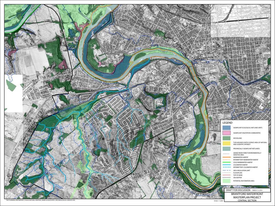
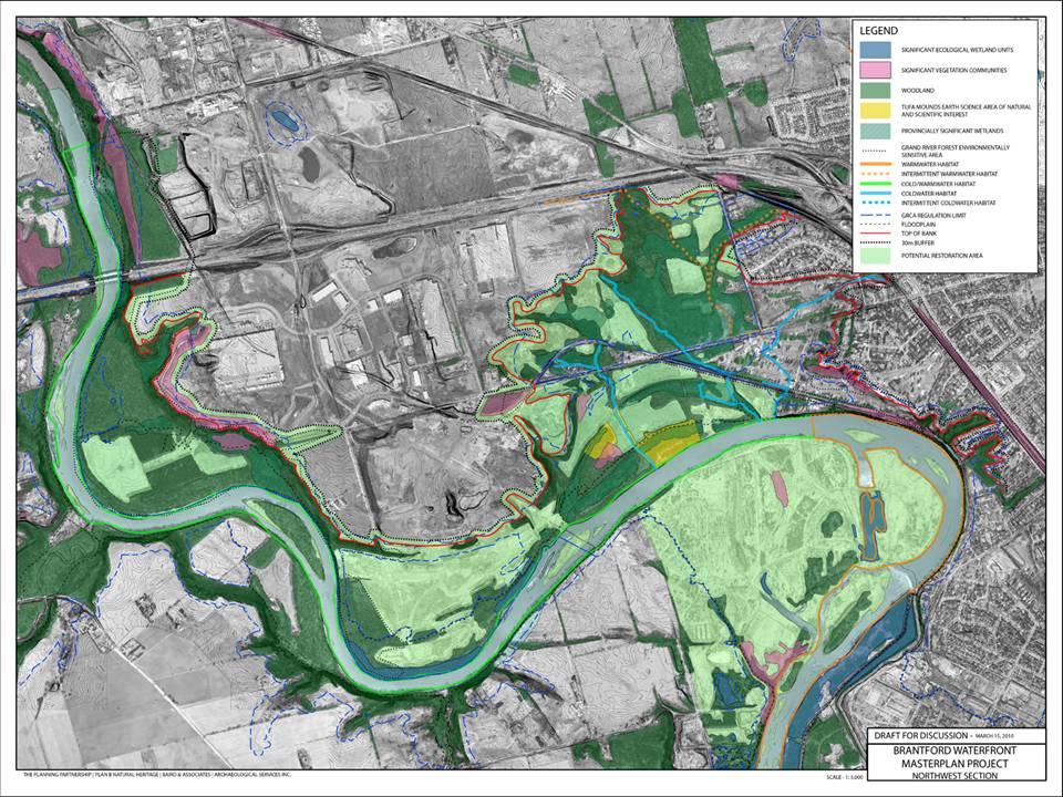
23 Initiatives 1. Restore and enhance natural areas: 30 m buffer, invasive plans, naturalization, corridor links, landscape management, rare species recovery, tree/woodlot bylaw 2. Riparian buffers: 30 m buffer planted with native species 3. Potential restoration areas: key connecting links to repair the health of the ecosystem 4. Reforest lands: urban neighbourhood reforestation program


24 Initiatives 5. Protect and improve water quality: low impact development storm water management measures flood plain wetlands 6. Meadow/prairie landscape on the dyke 7. Extend the Environmental Framework beyond City boundaries


25 Initiatives 8. Protect and enhance wildlife habitat: restoration of habitats implementation of habitat management guidelines for species at risk 9. Enhance the landscape of municipal parks 10. Erosion and flood protection

26
27


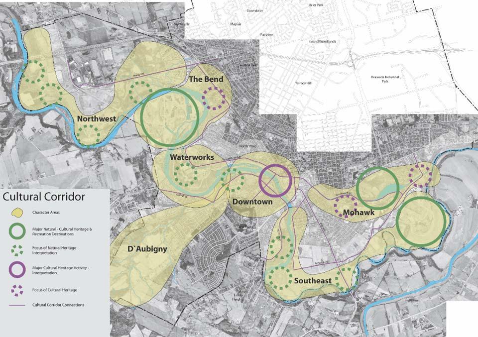
28 1. Character areas: each rich with stories to tell: industrial heritage, Aboriginal culture, planned community, significant natural features 2. Major destinations as a focus of heritage, culture, natural features and recreation 3. Focus areas as key locations for heritage, culture and/or natural features 4. Major destination for heritage, arts, recreation in a new urban waterfront destination 5. Focus areas for for interpretation of heritage and culture 6. Cultural Corridor connections key streets that link the destinations and focus areas

29


30 1. Destinations: cultural entertainment sports facilities and venues 2. Coordinated signage 3. Coordinated marketing and promotion 4. Optimize access to the River 5. Demonstrate the very best in environmental practices

31

32 Brant Waterworks Mohawk


33 1. Continuous linear greenway: extend a continuous linear greenway along the River through the North west and South east and long the Canal 2. Environment First Master Plan for Brant Conservation Area: consistent with the direction of the Waterfront Master Plan, accommodate year round access 3. Enhancing existing parks: Natural Environment, Sports and Destination parks; appropriate uses, landscape management, implementing recommendations from previous plans 4. New parks in the North west and South east: to capitalize on current City-owned lands and to ensure public access 5. Long term rehabilitation of the landfill: phased implementation of a rehabilitated landfill, enhance the view from Mohawk Street, the park and canal

34

35


36 1. Primary Waterfront Trail: missing link north side of Mohawk Lake six segments 2. Riverside footpath extended through the South east 3. Boat access: 7 locations for canoes, kayaks and rafts vegetated buffer limit road and ramps 4. Green streets - key connections to neighbourhoods to capitalize on current Cityowned lands and to ensure public access to the river 5. Strategy for information and signage

37

38 Existing Urban Areas
39 Potential Development Areas Northwest Industrial Area Holmedale Greenwich-Mohawk/Colborne West Brant Lower Downtown Eagle Place Neighbourhood
40 Existing Urban Areas Guidance for protecting & enhancing the urban interface with the Waterfront


41 Existing Urban Interfaces River Rd Gilkison Rd Forest Rd

42 Existing Urban Interfaces

43 Existing Urban Interfaces
44 Potential Development Areas Guidance for neighbourhood & district design & the urban interface with the Waterfront Northwest Industrial Area Holmedale Greenwich-Mohawk/Colborne West Brant Lower Downtown Eagle Place Neighbourhood
45 Potential Development Areas

46 Potential Development Areas
47 All Urban Areas The goal is to ensure a connected, coherent, civic-inspired & harmonious urban relationship with the waterfront
48 Principles (new) 1. Protect & integrate natural & heritage features & resources 2. Protect & enhance existing established neighbourhoods 3. Enhance visual & physical connectivity to the waterfront 4. Integrate new developments within a comprehensively considered plan 5. Build on the exceptional strengths of local city-building traditions 6. Maximize safety & accessibility along the waterfront for as many residents as possible 7. Strive for life-long, complete, and walkable communities 8. Developments last for generations important to get it right New developments should contribute positively to the waterfront and the City s image by showcasing the highest standards & best practices in sustainable development, urban design & architecture
49 Initiatives 1. Create waterfront gateways celebrate access points with identifiable markers and coordinated design strategies 2. Create an exciting Downtown urban waterfront & attraction 3. Protect & enhance existing urban interfaces that work 4. Address existing urban interfaces in need of improvement soften edges, façade improvements, new access opportunities, CPTED principles 5. Harmonize existing development proposals with this Plan 6. Proactively plan & design future potential development areas 7. Adopt design guidelines for new neighbourhoods & distircts 8. Amend the Official Plan & zoning to be consistent with this Plan
50 General Design Guidelines for New Neighbourhoods
51 General Design Guidelines for New Neighbourhoods Plan within the neighbourhood context
52 General Design Guidelines for New Neighbourhoods Protect natural features & heritage resources
53 General Design Guidelines for New Neighbourhoods Provide transitional buffers
54 General Design Guidelines for New Neighbourhoods Open space connections to the waterfront
55 General Design Guidelines for New Neighbourhoods Extend or create a walkable street grid

56 General Design Guidelines for New Neighbourhoods windows & gateways to the waterfront

57 General Design Guidelines for New Neighbourhoods Face & address the waterfront

58 General Design Guidelines for New Neighbourhoods High quality public realm & enhanced city views

59 General Design Guidelines for New Neighbourhoods

60 Recommendations for Target Areas Northwest Industrial Area Lower Downtown Eagle Place Neighbourhood

61 Northwest Industrial Area Oak Park Rd Oak Park Rd Hwy 403 Hardy Rd Protection of internationally significant archeological & natural assets Retention of employment lands in an extraordinary natural setting Opportunity to attract sustainable minded industries & offices in a campus format Showcase sustainable streetscapes, stormwater management & landscapes Brantford Golf & Country Club


62 Northwest Industrial Area

63 Lower Downtown Brant Brant Ave Ave Colborne St Water St Icomm Dr Enabled by potential closure of rail spur High density mixed uses & cultural attractions in Downtown block pattern Promenade with cafes and restaurants as an urban waterfront edge Development sleeve for parking structures & casino Centred on east west linear open space connection & historic station Potential new arena complex in partnership with university Casino Earl Haig Park Civic Centre Brantford Brantford Southern Southern Access Access Rd Rd Market St Market St Rivergreen Park Farmer s Market Erie Erie Ave Ave Clarence St Clarence St

64 Lower Downtown

65 Lower Downtown

66 Eagle Place Neighbourhood Mohawk St Baldwin Ave Eagle Place Community Centre John Wright Soccer Complex River Rd River Rd Integrated with adjacent neighbourhoods Interconnected linked street network & midblock connections Dyke & trail as key waterfront resource with continuous public frontage & access Joseph Brant School Brant County Board Erie Ave Erie Ave 5 th th Ave Birkett BirkettLaneLane Variety of open space types & scales Variety & mix of densities according to a rational structure A mixed-use neighbourhood focus & centre

67 Eagle Place Neighbourhood


68 Eagle Place Neighbourhood
I m p l e m e n t a t i o n. M a n a g e m e n t
 IMPLEMENTATION 95 I m p l e m e n t a t i o n This chapter includes recommendations for managing the implementation of the initiatives described in each of the components of the Waterfront Master Plan.
H e r i tag e & C u lt u r e
 H e r i tag e & C u lt u r e 61 4 H e r i t a g e & C u l t u r e W h a t W e H e a r d The City of Brantford s Waterfront Master Plan presents a unique opportunity to understand the diverse array of
waterfront Master Plan
 ThePlanningPartnership in association with PLAN B Natural Heritage Baird & Associates TCI Management Consultants Archaeological Services Inc. June 2010 C I T Y O F B r a n t f o r d waterfront Master Plan
DOMINION BOULEVARD CORRIDOR STUDY AND ECONOMIC DEVELOPMENT STRATEGIC PLAN A MODEL FOR CHESAPEAKE S FUTURE
 DOMINION BOULEVARD CORRIDOR STUDY AND ECONOMIC DEVELOPMENT STRATEGIC PLAN A MODEL FOR CHESAPEAKE S FUTURE Overview I. Draft Plan Process II. Draft Plan Overview a. Market Analysis b. Master Land Use Plan
The Planning Partnership Baird + Associates TCI Management Consultants Ltd. Plan B Natural Heritage Wills Consulting Engineers Poulos & Chung Limited
 Little Lake Master Plan The Planning Partnership Baird + Associates TCI Management Consultants Ltd. Plan B Natural Heritage Wills Consulting Engineers Poulos & Chung Limited May 26, 2009 Purpose of Study
This page intentionally blank.
 This page intentionally blank. Parks, Recreation, and Open Space Chapter Relationship to Vision Vision Parks, Recreation and Open Space Chapter Concepts County Government. County government that is accountable
Parks, Open Space and Trails
 Introduction Parks have often been referred as the lungs of our cities, cleansing the air of pollutants and particulate matter. Parks are also gathering places for families and community. They offer spaces
TOWN OF INNISFIL SPECIAL COUNCIL AGENDA OUR JOBS INNISFIL HEIGHTS WORKSHOP WEDNESDAY JANUARY 20, :30 P.M.
 January 13, 2016 TOWN OF INNISFIL SPECIAL COUNCIL AGENDA INNISFIL HEIGHTS WORKSHOP WEDNESDAY JANUARY 20, 2016 5:30 P.M. PLEASE REMEMBER TO TURN OFF CELL PHONES 1. OPENING OF MEETING BY THE MAYOR Opening
MAYFIELD WEST SECONDARY PLAN PHASE 2
 MAYFIELD WEST SECONDARY PLAN PHASE 2 Public Open House #3 February 25, 2010 Draft Preferred Land Use Scenario TOWN OF CALEDON PLANNING & DEVELOPMENT DEPARTMENT Open House Agenda TOWN OF CALEDON 1. Welcome
CITY CLERK. Parkland Acquisition Strategic Directions Report (All Wards)
") CITY CLERK Clause embodied in Report No. 10 of the, as adopted by the Council of the City of Toronto at its meeting held on November 6, 7 and 8, 2001. 10 Parkland Acquisition Strategic Directions Report
CITY CLERK Clause embodied in Report No. 10 of the, as adopted by the Council of the City of Toronto at its meeting held on November 6, 7 and 8, 2001. 10 Parkland Acquisition Strategic Directions Report
Comprehensive Plan Advisory Panel Meeting #3
 Comprehensive Plan Advisory Panel Meeting #3 November 7, 2016 Agenda 1. September 19 th Meeting Notes 2. Summary of Focus Areas Charrette 3. Heart of the City Focus Area a. HOC2/Station Areas Concept &
Town of Peru Comprehensive Plan Executive Summary
 Town of Peru Comprehensive Plan Executive Communities that plan grow by choice, not by chance. A plan makes growth thoughtful, understandable, and predictable. A plan shows that a community is managing
1.0 Purpose of a Secondary Plan for the Masonville Transit Village
 Report to Planning and Environment Committee To: Chair and Members Planning & Environment Committee From: John M. Fleming Managing Director, Planning and City Planner Subject: Masonville Transit Village
SUBJECT: Waterfront Hotel Planning Study Update TO: Planning and Development Committee FROM: Department of City Building. Recommendation: Purpose:
 Page 1 of Report PB-23-18 SUBJECT: Waterfront Hotel Planning Study Update TO: Planning and Development Committee FROM: Department of City Building Report Number: PB-23-18 Wards Affected: 2 File Numbers:
A BLUEPRINT FOR BROCKTON A CITY-WIDE COMPREHENSIVE PLAN
 A BLUEPRINT FOR BROCKTON A CITY-WIDE COMPREHENSIVE PLAN Public Meeting October 2016 1 Plan Summary and Discussion Public Meeting May 4 2017 City of Brockton Bill Carpenter, Mayor Department of Planning
Presentation of the Staff Draft. July 17, 2014 SSRVP Team, Area 3
 Presentation of the Staff Draft July 17, 2014 SSRVP Team, Area 3 Presentation Overview Introduction Plan Framework Plan Recommendations Implementation Next Steps and Request for Public Hearing on September
John M. Fleming Managing Director, Planning and City Planner. Old East Village Dundas Street Corridor Secondary Plan Draft Terms of Reference
 Report to Planning and Environment Committee To: From: Subject: Chair and Members Planning & Environment Committee John M. Fleming Managing Director, Planning and City Planner Old East Village Dundas Street
Parks Master Plan Implementation: Phase I Waterfront Use and Design REPORT #: September 7, 2016 File #
 0 'O DI Lan-171-14 1 - THE CORPORATION OF THE TOWN OF COBOURG..,. STAFF REPORT TO: FROM: Mayor and Members of Council Dean A. Hustwick, Director of Recreation and Culture DATE OF MEETING: Committee of
PORT WHITBY COMMUNITY
 PORT WHITBY COMMUNITY SECONDARY PLAN UPDATE COMMUNITY IMPROVEMENT PLAN URBAN DESIGN GUIDELINES September 2015 DRAFT PROPOSED AMENDMENT NUMBER # to the Whitby Official Plan PURPOSE: The intent of this Amendment
Regional Context Statement
 Regional Context Statement REGIONAL CONTEXT STATEMENT 3. REGIONAL CONTEXT STATEMENT In 1995, the Provincial Government passed into law the Growth Strategies Act. The purpose of this provincial initiative
Downtown Whitby Action Plan
 Downtown Whitby Action Plan Final Report October 2016 Table of Contents Introduction 1 Public Consultation 2 Walkability 3 Downtown Whitby Walkability Map 4 Vision 5 Goal & Objectives 6 Objective 1 7 Objective
THE GARDEN CITY PLAN. City of St. Catharines Official Plan. City of St. Catharines
 THE GARDEN CITY PLAN City of St. Catharines Official Plan City of St. Catharines August 2010 APPROVAL INFORMATION This Official Plan of the City of St. Catharines Planning Area, known as the Garden City
Edward R. Sajecki Commissioner of Planning and Building
 Corporate Report Clerk s Files Originator s Files CD.03.POR DATE: TO: FROM: SUBJECT: Chair and Members of Planning and Development Committee Meeting Date: February 27, 2012 Edward R. Sajecki Commissioner
SECTION ONE: INTRODUCTION. introduction
 introduction 1 INTRODUCTION Since it was first established in 1843 as a trading post for the Hudson s Bay Company, Victoria has evolved into a Provincial capital city that is recognized across Canada and
Route 347. New York State Department of Transportation Region 10, Long Island. THE GREENING of ROUTE 347
 The GREENING of Route 347 The Greening of Route 347 The Greening of Route 347: History 3 The Greening of Route 347 4 The Greening of Route 347 5 The Greening of Route 347 Smith Haven Mall 6 The Greening
The Official Plan of The City of Brantford
 The Official Plan of The NOTE TO USERS The following document is an office consolidation of the Official Plan of the City of Brantford originally approved by the Minister of Municipal Affairs on November
COMMUNITY SUSTAINABILITY AND ENVIRONMENTAL MASTER PLAN IMPLEMENTATION UPDATE
 Attachment 1 COMMUNITY SUSTAINABILITY AND ENVIRONMENTAL MASTER PLAN IMPLEMENTATION UPDATE Priorities and Key Initiatives Committee May 2013 Page E-1 How we grow Goal 2: To ensure sustainable development
LAKEVIEW LOCAL ADVISORY PANEL. THE COPORATION OF THE CITY OF MISSISSAUGA THURSDAY, NOVEMBER 18, 2010
 LAKEVIEW LOCAL ADVISORY PANEL THE COPORATION OF THE CITY OF MISSISSAUGA www.mississauga.ca/lakeviewportcreditreview THURSDAY, NOVEMBER 18, 2010 MISSISSAUGA SENIORS CENTRE LUCY TURNBALL ROOM (1389 Cawthra
Niagara Region Official Plan. Table of Contents
 Niagara Region Official Plan Table of Contents This page has been intentionally left blank. Table of Contents ii Niagara Region Official Plan Niagara Region Official Plan - Table of Contents Chapter 1
ADOPTED CAPITAL IMPROVEMENT PROGRAM BUDGET ARROYO PROJECTS
 ADOPTED CAPITAL IMPROVEMENT PROGRAM BUDGET ARROYO PROJECTS HAHAMONGNA FY 212-216 Capital Improvement Program Priority Description Total Estimated Costs Appropriated Through FY 211 Adopted FY 212 FY 213
CHAPTER 5: GUIDING PRINCIPLES
 CHAPTER 5: GUIDING PRINCIPLES The following 10 principles were developed based on public consultation, planning policy and the background analysis conducted during Phase 1. The Guiding Principles significantly
The Mystic River Greenway
 The Mystic River Greenway City of Medford November 30, 2006 MIT Department of Urban Studies and Planning The Mystic River Greenway A greenway is a regional network that connects: Open Space Visibility,
edmonton.ca/ribbonofgreen #ribbonofgreen
 WHAT IS THE RIBBON OF GREEN? The Ribbon of Green is Edmonton s entire river valley and ravine system. The Ribbon of Green (2018) Project will provide strategic guidance for the southwest and northeast
Community Design Guidelines. Port Wallace DRAFT
 Community Design Guidelines Port Wallace DRAFT Energy 1 2 3 Nature Movement Connections Built Form DRAFT Layout Energy 1 Nature Community Design Guidelines GREAT COMMUNITIES PROTECT, CELEBRATE, AND CONSERVE
DISCUSSION TOPIC: ST JOHNS RIVER & ITS TRIBUTARIES (BPII) 2030 COMPREHENSIVE PLAN POLICES AND REGULATORY FRAMEWORK
 2030 COMPREHENSIVE PLAN POLICES AND REGULATORY FRAMEWORK") DISCUSSION TOPIC: ST JOHNS RIVER & ITS TRIBUTARIES (BPII) 2030 COMPREHENSIVE PLAN POLICES AND REGULATORY FRAMEWORK St. John s River & Its Tributaries Issue Summary: The St. Johns River is an important
DISCUSSION TOPIC: ST JOHNS RIVER & ITS TRIBUTARIES (BPII) 2030 COMPREHENSIVE PLAN POLICES AND REGULATORY FRAMEWORK St. John s River & Its Tributaries Issue Summary: The St. Johns River is an important
S A C R A M E N T O C O U N T Y JACKSON HIGHWAY & GRANT LINE EAST VISIONING STUDY
 JACKSON HIGHWAY & GRANT LINE EAST S A C R A M E N T O C O U N T Y P L A N N I N G D E P A R T M E N T SUMMARY AND WORKBOOK November 19, 2008 History of the Visioning Study Sacramento County has two growth
City of Missoula and Missoula County Open Space Planning Open House
 City of Missoula and Missoula County Open Space Planning Open House FEBRUARY 6, 2018 The following slides contain the display board content from the open house. Please use boards to answer questions in
National Association of Conservation Districts. Kris Hoellen Vice President, Sustainable Programs The Conservation Fund September 19, 2013
 National Association of Conservation Districts Kris Hoellen Vice President, Sustainable Programs The Conservation Fund September 19, 2013 Our Mission The Conservation Fund forges partnerships to conserve
3 Vision and Goals. Vision and Goals. Blueprint for Bloomsburg. Vision. Town of Bloomsburg Comprehensive Plan,
 Vision and Goals 3 Vision and Goals Citizens of the Town of Bloomsburg clearly value their natural and cultural heritage, the walkable, mixed use pattern of downtown, the access to education, and the community
National Association of Recreation Resource Planners Conference
 DEVELOP INTERPRET RESTORE National Association of Recreation Resource Planners Conference Pittsburgh-to-Harrisburg Main Line Canal Greenway new connections between old neighbors Learning Objectives By
THE PROTECTION OF CHATHAM COUNTY S NATURAL RESOURCES - THE POLICY SIDE
 THE PROTECTION OF CHATHAM COUNTY S NATURAL RESOURCES - THE POLICY SIDE SEA GRANT TIDAL CREEK SUMMIT CHARLESTON, SOUTH CAROLINA DECEMBER 5, 2011 Jackie Jackson Teel Chatham County-Savannah Metropolitan
Complete Neighbourhood Guidelines Review Tool
 Complete Neighbourhood Guidelines Review Tool Prepared By: City of Regina Planning Department October 2014 Page 1 of 14 Community Development Review Checklist for Secondary Plans and Concept Plans The
Toronto Parks Renaissance Strategy
 Toronto Parks Renaissance Strategy Overview, Emerging Themes and Directions Presentation to EDPC, May 4, 2006 Parks Renaissance Strategy Presentation Agenda Project Overview Emerging Themes and Directions
T O W N O F H I G H R I V E R
 T O W N O F H I G H R I V E R o p e n s p a c e p l a n The Town of High River, 30 minutes South of Calgary, still retains much of its distinctive small town character and provides residents with a high
10.0 Open Space and Public Realm
 10.0 Open Space and Public Realm 10.0 Open Space and Public Realm The Public Open Space System is comprised of: outdoor spaces available for public use that are either publicly owned (e.g., parks and
Official Plan Review: Draft Built Form Policies
 PG.30.1 REPORT FOR ACTION Official Plan Review: Draft Built Form Policies Date: May 15, 2018 To: Planning and Growth Management Committee From: Chief Planner and Executive Director, City Planning Division
Town of Cobourg Heritage Master Plan. Statutory Public Meeting
 Town of Cobourg Heritage Master Plan Statutory Public Meeting April 25 th 2016 Presentation Overview 1. Introduction 2. Project background and schedule overview 3. Review of strategic direction content
The West Vaughan Employment Area Secondary Plan Policies
 Part 2: The West Vaughan Employment Area Secondary Plan Policies 2.1 General Policies It is the policy of Council: 2.1.1. That the West Vaughan Employment Area (the WVEA), identified on Schedule 1, will
PUBLIC SPACES MASTER PLAN UPDATE (POPS) Crystal City Citizen s Review Council October 24, 2018
 Crystal City Citizen s Review Council October 24, 2018") PUBLIC SPACES MASTER PLAN UPDATE (POPS) Crystal City Citizen s Review Council October 24, 2018 1 PLANNING CONTEXT Arlington County Comprehensive Plan UPDATE Related Documents: CIP Sector Plans Area Plans
PUBLIC SPACES MASTER PLAN UPDATE (POPS) Crystal City Citizen s Review Council October 24, 2018 1 PLANNING CONTEXT Arlington County Comprehensive Plan UPDATE Related Documents: CIP Sector Plans Area Plans
ARLINGTON COUNTY, VIRGINIA
 ARLINGTON COUNTY, VIRGINIA County Board Agenda Item Meeting October 15, 2005 DATE: September 28, 2005 SUBJECT: Request to Advertise the adoption of the 2005 Clarendon Sector Plan C. M. RECOMMENDATION:
Workshop 3. City of Burlington Waterfront Hotel Planning Study. September 14, The Planning Partnership
 Workshop 3 City of Burlington Waterfront Hotel Planning Study September 14, 2017 The Planning Partnership The Waterfront Hotel Planning Study 01 The Brant & Lakeshore Planning Study will establish a Strategic
Municipal Development Plan Update Urban Service Area and Hamlets
 ENCLOSURE 1 Municipal Development Plan Update Urban Service Area and Hamlets Priorities Committee January 24, 2017 MUNICIPAL DEVELOPMENT PLAN UPDATE SHAPING OUR FUTURE MDP Update - Agenda MDP Update Public
1.0 PLANNING MARKHAM S FUTURE CONTENTS
 1-1 Planning Markham s Future 1.0 PLANNING MARKHAM S FUTURE CONTENTS 1.1 THE PURPOSE OF THE OFFICIAL PLAN 1.2 THE MARKHAM CONTEXT 1.3 THE REGULATORY CONTEXT 1.3.1 Province of Ontario 1.3.2 York Region
WILLAMETTE FALLS LEGACY PROJECT
 OPPORTUNITIES & CONSTRAINTS There are here three falls on a line of rocks extending across the river, which forms the bed of the upper channel. The water is precipitated through deep abrazed gorges, and
Tonya Hunter, LLA, CA Environmental Consulting & Technology, Inc.
 Presented to: Michigan Water Environment Association Watershed Seminar December 5, 2013 Tonya Hunter, LLA, CA Environmental Consulting & Technology, Inc. What is Green Infrastructure? Green infrastructure
ARISE: The Rock Renaissance Area Redevelopment & Implementation Strategy
 2014 Professional Awards 1 ARISE: The Rock Renaissance Area Redevelopment & Implementation Strategy Janesville, WI Completed December 2014 Analysis & Planning Purpose of Project 2 The purpose of the Rock
University of Saskatchewan CAMPUS MASTER PLAN. Senate Meeting Preliminary Presentation. April 21, 2018 DIALOG ECS DA WATT
 University of Saskatchewan CAMPUS MASTER PLAN Senate Meeting Preliminary Presentation April 21, 2018 DIALOG ECS DA WATT project process presentation agenda Stakeholder Engagement Project Control phase1
MAYFIELD WEST SECONDARY PLAN PHASE 2
 MAYFIELD WEST SECONDARY PLAN PHASE 2 Council Information Workshop February 16, 2010 Draft Preferred Land Use Plan TOWN OF CALEDON PLANNING & DEVELOPMENT DEPARTMENT Workshop Agenda TOWN OF CALEDON 1. Welcome
Animating the Rideau Canal December 2013
 Executive Summary Animating the Rideau Canal December 2013 Why study the Rideau Canal? The Rideau Canal has been an important part of Ottawa throughout its history, and has shaped and been shaped by the
The Palisades Interstate Parkway and Henry Hudson Drive designated a New Jersey State Scenic Byway, 2005
 The Palisades Interstate Parkway and Henry Hudson Drive designated a New Jersey State Scenic Byway, 2005 What are scenic byways? How Did Scenic Byways Come About? National Scenic Byways Program Administered
PLAN ELEMENTS WORKSHOP. April 5, 2016
 PLAN ELEMENTS WORKSHOP April 5, 2016 needs more housing. But there is no one-size fits-all solution. Every neighborhood has its own character. In some places, density is not only appropriate it is badly
DOWNTOWN GEORGETOWN PLANNING STUDY
 DOWNTOWN GEORGETOWN PLANNING STUDY Downtown Visioning Workshop #1 Tuesday, February 20, 2018 The Planning Partnership 1 INTRODUCTION TO PROJECT THE TEAM The Planning Partnership Meridian Planning Consultants
TABLE OF CONTENTS INTRODUCTION PLAN CONCEPT... 3
 TABLE OF CONTENTS BY-LAW NO. Z-1 INTRODUCTION... 1 1.0 PLAN CONCEPT... 3 1.1 Mission... 3 1.2 A Future Vision for Fredericton... 3 1.3 Growth Strategy Goals... 5 National Context... 5 Provincial Context...
EXECUTIVE SUMMARY EXECUTIVE SUMMARY
 1 EXECUTIVE SUMMARY EXECUTIVE SUMMARY Penn s Landing is envisioned as a welcoming riverfront green space adjacent to a refurbished civic marina becoming the centerpiece for adjacent development. With a
Brampton. Secondary Plan. Review. Bram West. A New Direction in Planning & Public Consultation
 Brampton Bram West Secondary Plan Review A New Direction in Planning & Public Consultation Introduction The Bram West Secondary Plan Review offers an important opportunity for the community to define a
{Best Practices. Summary of Tools, Strategies and Best Practices from 11 Michigan Case Study Communities
 Case Studies Michigan Coastal Community Working Waterfronts { Summary of Tools, Strategies and from 11 Michigan Case Study Communities Table of Contents Zoning...2 Community and Stakeholder Collaboration
THE TOWN OF WASAGA BEACH
 THE TOWN OF WASAGA BEACH Downtown Development Master Plan Committee of the Whole Presentation January 26 th 2017 Uses within this designation should reflect a dependence on tourism as opposed to the permanent
City of Brookfield 2035 Comprehensive Plan. DRAFT #2 October 6, 2009
 City of Brookfield 2035 Comprehensive Plan DRAFT #2 October 6, 2009 Public Hearing Presentation: December 1, 2009 Process Overview Phase I: Community Visioning (2008) - Developed long-term vision to direct
Streets for People, Place-Making and Prosperity. #TOcompletestreets
 COMPLETE STREETS FOR TORONTO Streets for People, Place-Making and Prosperity COMPLETE STREETS: A NEW APPROACH A Complete Streets design approach considers the needs of all users people who walk, bicycle,
Urban Design Manual PLANNING AROUND RAPID TRANSIT STATIONS (PARTS) Introduction. Station Study Areas
 Introduction. Station Study Areas") 111111 PLANNING AROUND RAPID TRANSIT STATIONS (PARTS) Introduction The ION rapid transit system will link Waterloo, Kitchener and Cambridge through a central transit corridor (CTC). There are a number
111111 PLANNING AROUND RAPID TRANSIT STATIONS (PARTS) Introduction The ION rapid transit system will link Waterloo, Kitchener and Cambridge through a central transit corridor (CTC). There are a number
New Westminster Downtown Parking Strategy Public Open House #1 September 13, 2012
 New Westminster Downtown Parking Strategy Public Open House #1 September 13, 2012 The City is preparing a strategy for parking in Downtown New Westminster. The study team and a group of key stakeholders
EXECUTIVE SUMMARY DRAFT CHAPTER 1 INTRODUCTION EXECUTIVE SUMMARY
 CHAPTER 1 EXECUTIVE SUMMARY INTRODUCTION Through the joint efforts of the City of Tulsa planning staff and the Land Services division of Indian Nations Council of Governments (INCOG), the Berryhill Land
Oakland County s Green Infrastructure Vision. L. Brooks Patterson Oakland County Executive
 Oakland County s Green Infrastructure Vision L. Brooks Patterson Oakland County Executive Southeast Michigan 20 miles northwest of Detroit Consists of 910 square miles Population of 1.2 million More than
Introduction. Integrating Ecological Restoration of Estuarine Shorelines with Urban Community Revitalization Efforts. Ed Morgereth Biohabitats, Inc.
 Introduction Integrating Ecological Restoration of Estuarine Shorelines with Urban Community Revitalization Efforts Ed Morgereth Biohabitats, Inc. 5 th National Conference & Expo on Coastal and Estuarine
Planning for Staten. Habitat Restoration and Green Infrastructure. Island s North Shore
 Habitat Restoration and Green Infrastructure Planning for Staten Island s North Shore Community Board 1 March 1, 2018 NYC Parks Forestry, Horticulture, and Natural Resources Funded by the NYS Department
ARROYO PROJECTS ADOPTED CAPITAL IMPROVEMENT PROGRAM BUDGET
 A RROYO P ROJECTS ADOPTED CAPITAL IMPROVEMENT PROGRAM BUDGET FISCAL YEARS 214-218 HAHAMONGNA Priority Description 1 Hahamongna Watershed Park - Implement Master Plan 211,6 211,6 (77565) 2 Hahamongna -
DOWNTOWN GEORGETOWN PLANNING STUDY
 DOWNTOWN GEORGETOWN PLANNING STUDY Community Workshop #3 Thursday, May 4, 08 The Planning Partnership OVERVIEW OF STUDY, PROCESS & MILESTONES We are here PURPOSE OF THE STUDY To develop a clear vision
PUBLIC OPEN HOUSE HURONTARIO-MAIN CORRIDOR SECONDARY PLAN
 PUBLIC OPEN HOUSE HURONTARIO-MAIN CORRIDOR SECONDARY PLAN Tuesday, February 28, 2012 6pm 9pm 1 st Floor Atrium, City Hall 2 Wellington Street West, Brampton 1 POLICY FRAMEWORK The 2006 Provincial Growth
RECREATION, OPEN SPACE AND GREENWAYS ELEMENT GOALS, OBJECTIVES, AND POLICIES
 RECREATION, OPEN SPACE AND GREENWAYS ELEMENT GOALS, OBJECTIVES, AND POLICIES GOAL R-1: DEVELOP A RECREATION, OPEN SPACE AND GREENWAYS SYSTEM AS AN INTEGRAL COMPONENT OF AN OVERALL, COUNTY-WIDE ECONOMIC
City of Westbrook. 2 York Street Westbrook, Maine (207) Fax:
 Fax:") City of Westbrook DEPARTMENT OF PLANNING & CODE ENFORCEMENT 2 York Street Westbrook, Maine 04092 (207) 854-0638 Fax: 1-866-559-0642 WESTBROOK PLANNING BOARD TUESDAY, JANUARY 2, 2018, 7:00 P.M. WESTBROOK
City of Westbrook DEPARTMENT OF PLANNING & CODE ENFORCEMENT 2 York Street Westbrook, Maine 04092 (207) 854-0638 Fax: 1-866-559-0642 WESTBROOK PLANNING BOARD TUESDAY, JANUARY 2, 2018, 7:00 P.M. WESTBROOK
Anatomy of A Vibrant Downtown. Anatomy of a Vibrant Downtown
 Anatomy of A Vibrant Downtown The goal of MAIN ST. REVITALIZATION PLANNING is to provide a framework that will help transform your downtown into a VIBRANT DOWNTOWN a place where people love to LIVE, WORK,
38 Queen s University Campus Master Plan Part 1
 38 Queen s University Campus Master Plan Part 1 46 The Campus at the City Scale Chapter 4 The Campus at the City Scale 39 Queen s is an urban University centrally located in Kingston. Decisions made by
City of Toronto. Emery Village Transportation Master Plan
 City of Toronto Emery Village Transportation Master Plan May 2009 Emery Village Transportation Master Plan Toronto, ON May 2009 Consulting Inc. 100 York Blvd., Suite 300 Richmond Hill, ON L4B 1J8 Tel:
Courthouse Square Planning & Urban Design Study. Courthouse Square Working Group #13 October 15, 2014
 Courthouse Square Planning & Urban Design Study Courthouse Square Working Group #13 October 15, 2014 1 Courthouse Square Process Working Group Community Courthouse Square Advisory Groups & Civic Associations
CITY OF LANGLEY OFFICIAL COMMUNITY PLAN BYLAW, 2005, NO APPENDIX II - REGIONAL CONTEXT MAP
 CITY OF LANGLEY OFFICIAL COMMUNITY PLAN BYLAW, 2005, NO. 2600 APPENDIX II - REGIONAL CONTEXT MAP ± Legend Agricultural Mixed Employment Industrial Conservation & Recreation Regional City Centre Urban Containment
CHATHAM COUNTY S PATH TO SUSTAINABILITY - THE NATURAL RESOURCES SIDE
 CHATHAM COUNTY S PATH TO SUSTAINABILITY - THE NATURAL RESOURCES SIDE GEORGIA ENVIRONMENTAL CONFERENCE SAVANNAH, GEORGIA AUGUST 23, 2012 Jackie Jackson Teel Chatham County-Savannah Metropolitan Planning
LAND USE ELEMENT. Purpose. General Goals & Policies
 LAND USE ELEMENT Purpose This Land Use Element contains the goals and policies necessary to support the City s responsibility for managing land resources and guiding development through implementing regulations,
Small Area Plan. South Gateway
 Small Area Plan Adopted May 12, 2008 South Gateway Purpose. The South Gateway Small Area Plan defines the City s expectations for the future of the southern entrance to the City at Interstate 85 and Highway
Clovis Urban Greening Plan. Community Workshop #2 Northwest
 Clovis Urban Greening Plan Community Workshop #2 Northwest Thursday, October 9, 2014 WHAT IS AN URBAN GREENING PLAN? A guide to help the City to improve quality of life for residents Identification of
Report to: Development Services Committee Report Date: April 24, 2017
 SUBJECT: Cornell Rouge National Urban Park Gateway - Report on Design Charrette and Next Steps PREPARED BY: Lilli Duoba, MES, MCIP, RPP, Manager, Natural Heritage (ext. 7925) REVIEWED BY: Marg Wouters,
Dyersville Downtown Plan. Open House October 24, 2017
 Dyersville Downtown Plan Open House October 24, 2017 What is a Comprehensive Plan? - Vision - Guidance for decisions - Basis for regulations What is a Downtown Plan? - Understand priorities - Identify
GATEWAY AREA STRUCTURE PLAN
 CHESTERMERE GATEWAY AREA STRUCTURE PLAN COMMUNITY OPEN HOUSE SEPTEMBER 22 nd, 2015 PLAN AREA ± 512 hectares (± 1,265 acres) GATEWAY LOCATION UNDEVELOPED LANDS PRESENT AGRICULTURAL USE REGIONAL LAND USE
City of Farmington. Downtown Plan. Amendment to the 1998 Master Plan Adopted October 11, 2004
 City of Farmington Amendment to the 1998 Master Plan Adopted October 11, 2004 Introduction Planning Background 1 Scope and Components of the Plan Amendment 2 Concept Introduction 3 Plan Concepts 3 Conceptual
Lakeview and Port Credit District Policies Review Public Engagement Process
 Lakeview and Port Credit District Policies Review Public Engagement Process Brook McIlroy Planning + Urban Design/PACE Architects MSAi Architects Poulos and Chung Transportation Engineers December 11,
City of Kingston. North King s Town Secondary Plan Open House + Workshop #1 February 28, 2018
 City of Kingston North King s Town Secondary Plan Open House + Workshop #1 February 28, 2018 1 event agenda 30 min Panel Review + Discussion 30 min Presentation + Q&A 75 min Workshop Session 15 min Report
NORTH CLAYMONT AREA MASTER PLAN COMMUNITY WORKSHOP #1 FEBRUARY 3, 2016
 NORTH CLAYMONT AREA MASTER PLAN COMMUNITY WORKSHOP #1 FEBRUARY 3, 2016 1. Introduction To the team and to the Plan Planning Partners The Claymont Community WILMAPCO New Castle County Claymont Renaissance
City of Peterborough Draft Official Plan 2016 Part 1 (Sections A to C) Vision and Strategic Policies
 Vision and Strategic Policies") City of Peterborough Draft Official Plan 2016 Part 1 (Sections A to C) Vision and Strategic Policies Includes Figure 2 Commercial Structure and Schedule A-1 City Structure Table of Contents A. INTRODUCTION...
City of Peterborough Draft Official Plan 2016 Part 1 (Sections A to C) Vision and Strategic Policies Includes Figure 2 Commercial Structure and Schedule A-1 City Structure Table of Contents A. INTRODUCTION...
Transforming Saint John s Urban Heart -
 Transforming Saint John s Urban Heart - How Innovative Community Engagement Inspires a Bold Municipal Plan for a More Sustainable and Compact Saint John 2012 NNECAPA Conference - Brunswick, ME October
RIVERSIDE DESIGN CD-1 GUIDELINES. Adopted by City Council August 9, 1983
 $1 City of Vancouver Land Use and Development Policies and Guidelines Community Services, 453 W. 12th Ave Vancouver, BC V5Y 1V4 F 604.873.7344 fax 873.7060 planning@city.vancouver.bc.ca RIVERSIDE DESIGN
HALIFAX GREEN NETWORK PLAN
 HALIFAX GREEN NETWORK PLAN Community Planning & Economic Development Standing Committee June 21, 2018 Photo credit: Vlastimil Koutecky, Flickr Creative Commons HGNP PROCESS PHASE 1 FOUNDATIONS PHASE 2