Panelists: Panel Discussion Land Use & Sustainable Development Conference December 7, 2017
|
|
|
- Patience Booth
- 6 years ago
- Views:
Transcription


1 The Practicalities of Form Based Codes: Lessons from our Region Panel Discussion Land Use & Sustainable Development Conference December 7, 2017 Panelists: Amy Pfeiffer Director, Office of Downtown Revitalization, Town of Babylon, NY Patrick Cleary, AICP, CEP, PP, LEED AP, CNU A Principal, Cleary Consulting, Inc. Lee Ellman, AICP Planning Director, City of Yonkers, NY Moderator: Bonnie Von Ohlsen, AICP, RLA, LEED Green Assoc. Kimley Horn of New York, P.C. 1


2 Today s Discussion: In three different communities where each decided it was important to implement a Form Based Code Circumstances, reasons, community vision Successes Obstacles and Challenges Developing and adopting the code Implementation of the code Lessons Learned Is the current reality of new development meeting expectations of the original vision? 3 Locations: 2


3 3 Case Studies: Form Based Code Definition: A form based code is a land development regulation that fosters predictable built results and a high quality public realm by using physical form (rather than separation of uses) as the organizing principle for the code. A form based code is a regulation, not a mere guideline, adopted into city, town, or county law. A formbased code offers a powerful alternative to conventional zoning regulation. ( 3


4 Conventional Code vs. Form Based Code Zoning Map, Street Standards and a list of uses For each permitted use: Building Height, Setbacks Density or FAR Parking and Circulation Lot Coverage, Lot size Landscape, Lighting, Signage Etc Community vision based, Regulating Plan with emphasis on: Public spaces and civic involvement Neighborhoods Connectivity/walkability/recreation Form and Type of structure more important than land use Mix of uses variety of uses Hierarchy of Streets relationship of streets to buildings Shared parking/transit friendly Sustainable/environmentally sound Diagrammatic/graphic Design Standards Form Based Code Why? Primary components: Visioning /Public participation Transects Regulating Plan Full code vs. partial or specific area Define implementation process 4


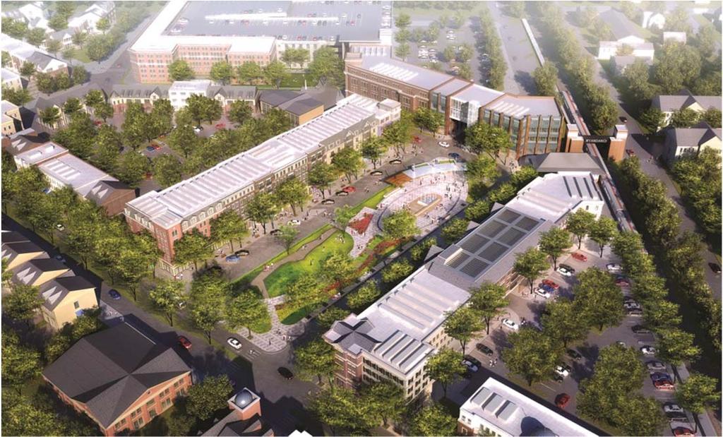
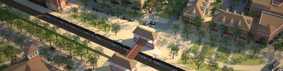
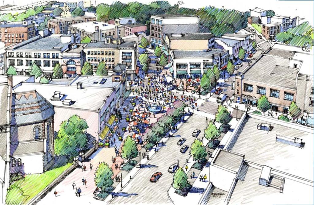
5 Town of Babylon, NY Wyandanch (2014) East Farmingdale (2017) A New Transit Oriented Development 5


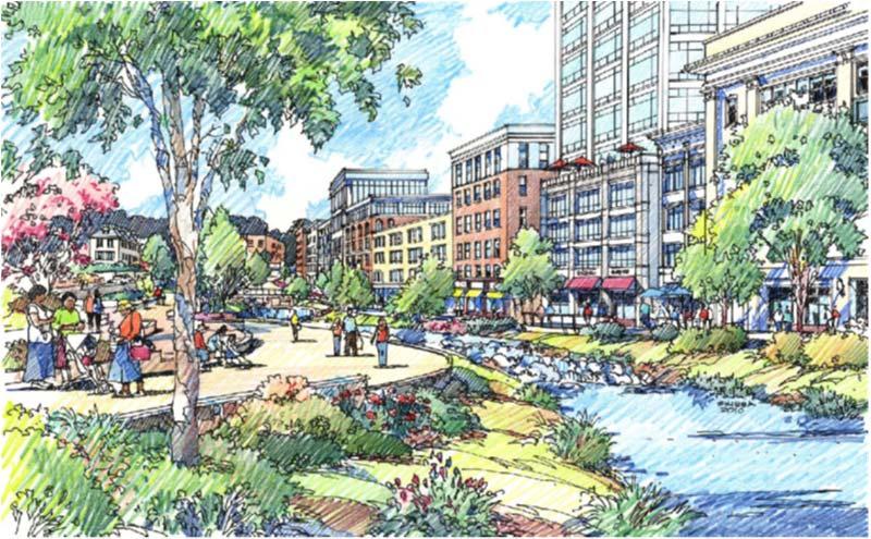
6 Property purchased for Wyandanch Village SITE ASSEMBLAGE OF APPROXIMATELY 40 ACRES OF KEY PROPERTY 6

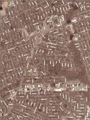
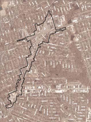
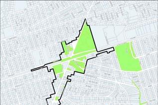
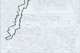
7 Urban Renewal Area 7

8 The Transect 8
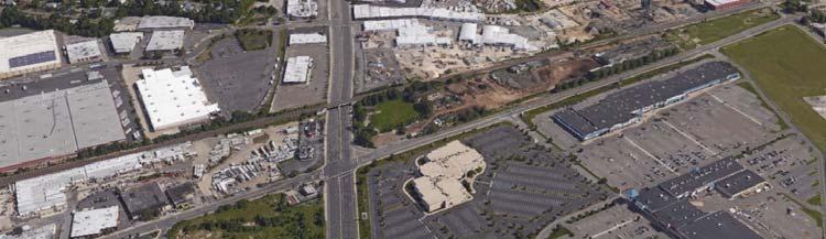
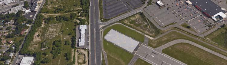


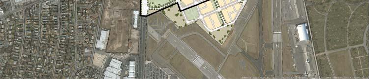
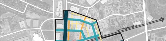
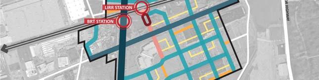
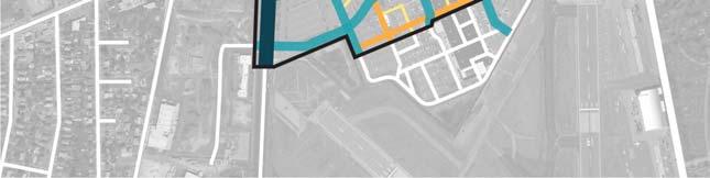
9 East Farmingdale TOD 9
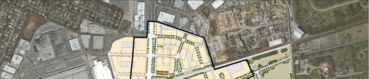
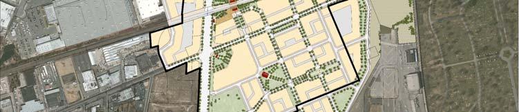
10 10


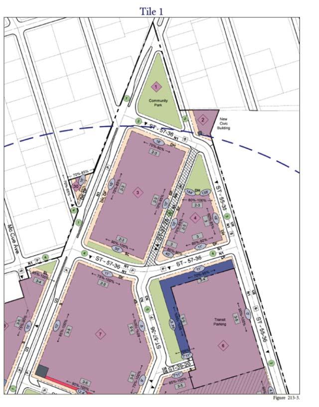
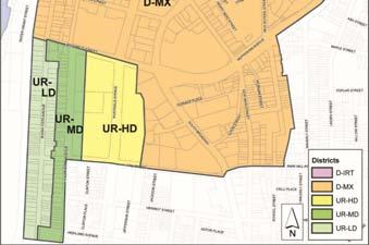
11 12/07/2017 PART 2: Regulating Plan T6: Station Area Mixed Use T5: Town Center Mixed Use T4: General Mixed Use Special District / Civic Property Line Build to Line Mandatory Shopfront Terminated Vista Landmark Building Regulating Plan 11
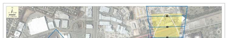
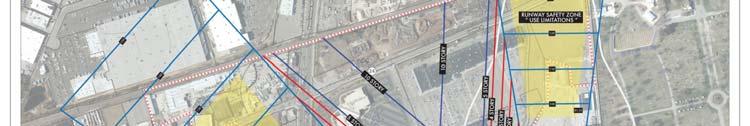

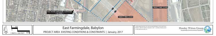
12 airport constraints PART 3: Transect Standards Suffolk County Executive Steve Bellone T6: Station Area Mixed Use 12

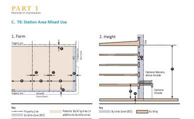
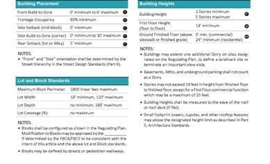
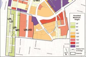
 80% min.")


13 PART 3: Transect Standards T6: Station Area Mixed Use: 0 to 6 Build-to-Zone (from right-of-way) 80% min. Frontage Occupancy (primarily attached buildings) Height: 2 Story min, 5 Story max PART 4: General Development Standards Support pedestrian-friendly, transit-oriented future development: Permitted Uses Parking Signage Lighting Landscape Open Spaces Stormwater Sustainable Design Affordable Housing 13
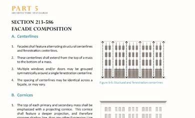
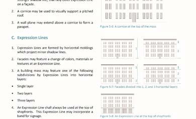
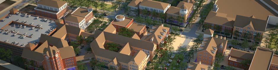
14 PART 5: Architecture Standards Facade Composition PART 6: Street Design Standards Street Atlas 14


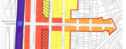
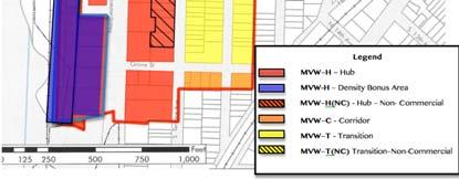
15 PART 6: Street Design Standards Street Types City of Mount Vernon, NY Mount Vernon West Transit Oriented Development Form Based Zoning Ordinance* (2017) *WMPF Planning Achievement Award winner 15

16 Mount Vernon West Transit Oriented Form Based Zoning 16
17 The area features a mix of residential, commercial and light industrial properties anchored by the MetroNorth commuter rail station. Mount Vernon Avenue is an important point of entry into Mount Vernon from Yonkers immediately to the west. It is a heavily trafficked street with an eclectic mix of commercial uses and varied architecture. Although the area is reasonably lively near the station, an increasing number of properties are vacant or available for sale or rent beyond the station. Within a short walk of the station a number of light industrial buildings are present, some in active use, but others are underutilized. Fall strategic visioning sessions were conducted, facilitated by Pace University. The first identified issues, concerns and actions and in turn planning goals. The second prioritized actions. Opportunities: The historic train station Transit access Pedestrian access Underutilize land The Bronx River MacQuesten Parkway Issues: Property ownership Station operations Mulit modal connections Pedestrian access Neighborhood character Parking Traffic Truck access Zoning 17
 and underutilized sites. 4.")


18 1. Position Mount Vernon West as a concentrated investment area. 2. Strengthen the Mount Vernon Avenue gateway from Mount Vernon from Yonkers. 3. Explore high density options through rezoning and the assembly of vacant parcels (buildings) and underutilized sites. 4. Develop a strategy for streetscape and façade improvements that ensures street frontage along principal streets. 5. Make general improvements to the public realm throughout the area including open space, landscaping, lighting, signage and graphics. 6. Renovate the train station and create a more inviting pedestrian environment and accommodate taxis and kiss and ride drop offs. 7. Enhance the aesthetic quality and functioning of the intersection of Mount Vernon Ave. with Lincoln Ave. and Stevens Ave. 8. Work with property owners wishing to upgrade or repurpose existing buildings. Relying on one or two key projects to jump start the overall revitalization of the area would not guarantee that the City s planning goals would necessarily be achieved. A much more comprehensive and inclusive approach was determined to be necessary. The zoning approach selected to facilitate the goals of the Mount Vernon West area reflects combination of zoning tools; incorporating: Form Based zoning Transit Oriented Development (TOD) zoning Smart Growth and New Urbanism principles Green Building based on LEED Neighborhood Development standards 18
19 Form Based Zoning A method of regulating development to achieve a specific urban form. Unlike traditional zoning which regulates primarily by use, Form Based Zoning Codes create a predictable public realm primarily by controlling physical form, with a lesser focus on land use. Transit Oriented Development (TOD) zoning Zoning that concentrates sustainable, compact, mixed use development around a transit hub and facilitates pedestrian activity. By combining a full array of land uses, including residences, work places and shopping, all within a ¼ mile area, dependence on individual automobile trips are reduced. Proximity to a transit hub solves the last mile problem. Smart Growth and New Urbanism Smart Growth and New Urbanism are community planning concepts that promote the creation of compact, transit oriented neighborhoods through thoughtfully conceived place making. Following these theories neighborhoods should be diverse in use and population, designed for pedestrians and transit as well as the car, shaped by physically defined and universally accessible public spaces and community institutions and framed by architecture and landscape design that celebrate local history, climate, ecology, and building practice. Green Building based on LEED Neighborhood Development standards Building that is environmentally responsible and resource efficient throughout a building's lifecycle. LEED ND integrates the principles of smart growth, new urbanism and green building into the first national independent third party Green Building rating system for neighborhood design. 1. General Provisions a) Overview b) Applicability c) Purpose & Intent d) Organization e) Relationship to Comprehensive Plan f) Planning Principles g) Non Conforming Uses and Buildings 19

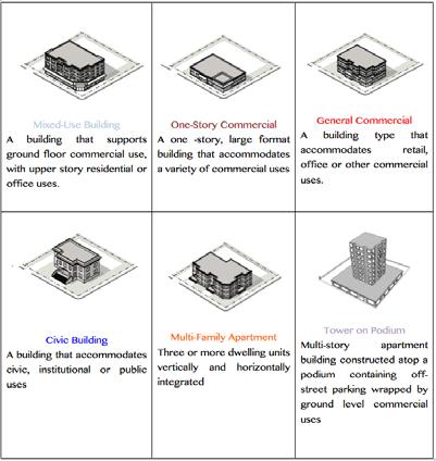
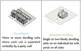
20 2. Regulating Plan 3. Allowable Building Types 20


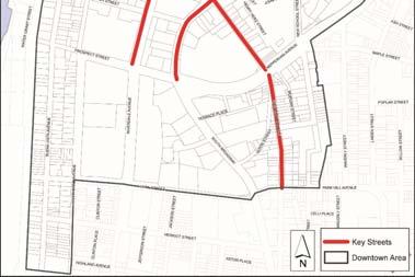
21 4. Permitted Building Types by District 5. Building Type Regulations Mixed Use Building Type 21


22 6. Permitted Uses 7. Parking Requirements A. Off Street Parking Requirements B. Shared Parking C. Design & Layout 22


23 8. Design Guidelines a. Architectural Details b. Ground Floor Facades c. Corner Building Wraps d. Functional Entries e. Building Off Sets f. Building Transitions g. Building Materials h. Windows and Doors i. Awnings j. Signs k. Site Lighting l. Building Services m. Project Open Spaces n. Streetscape o. Traffic Calming p. Pedestrian & Bicycle Circulation q. Landscaping r. Sustainability & Green Building Examples of Design Guidelines 23


24 Examples of Design Guidelines The new zoning must comply with SEQRA. The City prepared a Generic Environmental Impact Statement (GEIS) to evaluate the potential impacts of the proposed zoning, and to identify the required mitigation measures. Future projects that are consistent with the review thresholds established in the GEIS would need no further SEQRA review, or only well defined and limited review. This process will greatly reduce uncertainty and time delays in the approval process. 24


25 Given the City s limited resources, funding for the Mount Vernon West Rezoning Initiative was sought from potential developers. Developers were eager to participate, recognizing the benefits in timing, costs and approval certainty for conforming projects. Potential developers funded an escrow account, which was drawn from to fund the rezoning initiative. The rezoning initiative was a City action. Now that the MVW zoning has been adopted, developers are free to advance individual development applications. 25
:")


26 Three track review process: No Review Type II Actions Expedited Review (approval by Expedited Review Committee): Project wholly located within MVW zone No waivers or variances Complies with SEQR Findings Not a Type I Action Does not exceed 249 dwelling units or 99,000 square feet of non residential floor area. Full Review City of Yonkers, NY Downtown rezoning (2011) 26


27 Rezoning Downtown Yonkers Presentation to Downtown Rezoning City Council Real Estate Committee by Commissioner Louis C. Kirven


28 3-D Visual Modeling FORM BASED vs. TRADITIONAL ZONING Form-based Traditional Regulatory Focus Physical Urban Form Land Use Goals Desirable Urban Form Pedestrian Environment Preservation of Community Character Tools Smaller Area Layered Regulation Build To vs. Set Back Building Façade Crucial Land Use Separation Management of Density & Building Height Parking Block or Larger Districts Set Back & Building Separation Regulations Site Planning vs. Site & Building 28


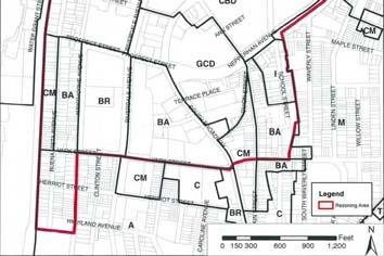


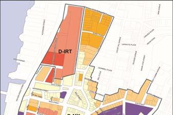
29 Existing Downtown Districts Proposed Zoning Maps 29


30 Key Streets The purpose of the Key Streets is to preserve and enhance the pedestrian-oriented commercial environment. promote economic development focused on active uses such as retail, restaurants, service and entertainment uses. To achieve this, Regulations require certain ground floor uses, a storefront design at the street level and increased transparency requirements. 30


 Fuss &")


31 Downtown Rezoning Consultants Urban Design Associates (UDA) Urban Design Fuss & O Neill Traffic and Transportation RCLCO Market Analysis/ Economic Development Urban Simulation Project Urban Design & Visual Simulation Camiros, Ltd. Zoning Buckhurst Fish & Jacquemart Environmental Analysis 31


32 32
33 Panel Discussion Questions for panel: Can each of you describe a built project that has come out of this process, and do you feel the FBC has been an effective tool to accomplish the communities goals? How did this idea come about and get implemented? Who were the initiators or stakeholders (market forces? Political forces? Grass roots?) How hard was it to sell to the decision makers? Now that you are though (code adopted), do you feel the FBC was worth it? (seeing great results that would not have happened with traditional zoning?) Discuss different scales involved in your communities, smaller area and projects, vs. master developer. Was there significant additional training involved? New Staff required? learning curve? Discuss how the SEQR process was handled, was the local approval process changed in theses areas? 33
34 References: Congress for New Urbanism Form Based Codes Institute American Planning Association The Rules That Shape Urban Form Planning Advisory Service Report #570 (Elliott, Goebel and Meadows) Applying Form Based Codes in the Real World (Elliott, Lorn, Russell, Voss) The Practicalities of Form Based Codes (and How They re being Applied in Albany) (Dover and Elliott, 2016) Essential Smart Growth Fixes for Urban and Suburban Zoning Codes (US EPA 231 K ; November 2009) City of Yonkers, NY Town of Babylon, NY City of Mount Vernon, NY Thank You! Form Based Codes: Panel Discussion Land Use & Sustainable Development Conference December 7,
Town Center (part of the Comprehensive Plan)
") Town Center (part of the Comprehensive Plan) Mercer Island Town Center Looking North (2014) In 1994, a year-long process culminated in a set of design guidelines and code requirements for the Town Center
Town Center (part of the Comprehensive Plan) Mercer Island Town Center Looking North (2014) In 1994, a year-long process culminated in a set of design guidelines and code requirements for the Town Center
City of Long Beach. creating vibrant and exciting places
 City of Long Beach creating vibrant and exciting places Land Use Element Urban Design Element Overview of the two draft General Plan elements Discuss areas of change Economic goals of the plans Case study
PLAN ELEMENTS WORKSHOP. April 5, 2016
 PLAN ELEMENTS WORKSHOP April 5, 2016 needs more housing. But there is no one-size fits-all solution. Every neighborhood has its own character. In some places, density is not only appropriate it is badly
FUTURE LAND USE ELEMENT
 FUTURE LAND USE ELEMENT GOAL I: To create and sustain a great place to live, play, and prosper Objective 1: The City of Ocala shall incorporate the principles and strategies of the Ocala 2035 Vision into
Equitable Growth Through TOD Planning
 Equitable Growth Through TOD Planning Community Meeting # 2 November 2017 Goals Objectives Extend investment from downtown Connect neighborhoods physically and economically Enhance places based on local
FRUITVALE TRANSIT VILLAGE (Phase 2) Residential Project
 Residential Project") FRUITVALE TRANSIT VILLAGE (Phase 2) Residential Project DEVELOPER: SIGNATURE PROPERTIES ARCHITECT: HKIT ARCHITECTS April 23, 2010 TABLE OF CONTENTS 3 Vision 4 Description of Site 5 Guiding Concepts 6
FRUITVALE TRANSIT VILLAGE (Phase 2) Residential Project DEVELOPER: SIGNATURE PROPERTIES ARCHITECT: HKIT ARCHITECTS April 23, 2010 TABLE OF CONTENTS 3 Vision 4 Description of Site 5 Guiding Concepts 6
City of Lake Mary, Florida. Evolution of a Historic Downtown with Transit Oriented Development Strategies
 City of Lake Mary, Florida Evolution of a Historic Downtown with Transit Oriented Development Strategies What is Transit Oriented Development? Walkable villages located at and around transit stations in
EXISTING COMPREHENSIVE PLAN
 EXISTING COMPREHENSIVE PLAN Town Center Land Use Element: V. LAND USE POLICIES Town Center Mercer Island's business district vision as described in "Your Mercer Island Citizen-Designed Downtown" was an
Executive Summary. NY 7 / NY 2 Corridor
 Executive Summary NY 7 / NY 2 Corridor Transportation and Land Use Study December 2005 Prepared for: Town of Colonie Capital District Transportation Committee Prepared by: Introduction: Land use decisions
The Five Components of the McLoughlin Area Plan
 The Five Components of the McLoughlin Area Plan This documents contains the complete language of the five components of the McLoughlin Area Plan: The Vision Statement The Values The Guiding Principles
4.1.3 LAND USE CATEGORIES
 4.1.3 LAND USE CATEGORIES a. City Center District The City Center District incorporates the existing character and mix of uses in downtown Belmont to encourage redevelopment and new development in keeping
Policies and Code Intent Sections Related to Town Center
 Policies and Code Intent Sections Related to Town Center The Town Center Vision is scattered throughout the Comprehensive Plan, development code and the 1994 Town Center Plan. What follows are sections
WELCOME and introduction
 1 WELCOME and introduction Mobility Hub Locations within Burlington STUDY OVERVIEW STUDY OBJECTIVES The City of Burlington is developing four Area Specific Plans, one for each of Burlington s Mobility
Planning Board Briefing
 Planning Board Briefing Why Now? The Sector Plan Implementation Chapter States: Before Stage 1 begins, the following must occur: Approval of the Sectional Map Amendment. Approval of the Greater Lyttonsville
Urban Design 9Identity
 Urban Design 9Identity URBAN DESIGN IDENTITY Urban design is about connecting people to their places through the built environment, nature, and overall urban form. Done well, it creates a memorable space
Windsor Locks Transit-Oriented Development Planning Grant Request. Project Background
 Windsor Locks Transit-Oriented Development Planning Grant Request Project Background Downtown Windsor Locks runs along Main Street in the vicinity of the intersection of Routes 159 and 140. The current
Table of Contents. Elm Avenue Improvement Plan City of Waco, Texas. Introduction 1. Existing Context 1 Figure 1 2.
 Table of Contents Introduction 1 Existing Context 1 Figure 1 2 Plan Guidelines 3 Future Urban Form 4 The West-End 4 Main Street 6 The East-End 7 Figure 2 9 Public Improvement Recommendations 7 General
LEED-ND 101: Practical Strategies for Achieving Sustainability Goals. Travis Parker Lakewood Planning Director
 LEED-ND 101: Practical Strategies for Achieving Sustainability Goals Travis Parker Lakewood Planning Director Metro Vision Idea Exchange Oct 11, 2012 West Corridor Stations West Corridor Overview West
TRANSIT-ORIENTED DEVELOPMENT POLICY DRAFT. City Planning and Development Department Kansas City, Missouri
 TRANSIT-ORIENTED DEVELOPMENT POLICY DRAFT City Planning and Development Department Kansas City, Missouri What is Transit Oriented Development (TOD)? Development that focuses land uses around a transit
A. WHAT IS A GENERAL PLAN?
 I. Introduction A. WHAT IS A GENERAL PLAN? A general plan is the planning guideline for the future of a city. It contains goals and policies which regulate urban development, the protection of the natural
CHAPTER 3 VISION, GOALS, & PLANNING PRINCIPLES. City of Greensburg Comprehensive Plan. Introduction. Vision Statement. Growth Management Goals.
 CHAPTER 3 VISION, GOALS, & PLANNING PRINCIPLES Introduction The Greensburg Comprehensive Plan is intended as a working community document. A combination of long and short-term goals, this document is intended
Tonight s Agenda. Summary Presentation Open House. Group Discussion Next Steps: online community wide survey
 Community Open House February 22, 2018 Tonight s Agenda Summary Presentation Open House Station 1: Project Overview and Community Input Station 2: Draft Vision and Guiding Principles Station 3: Western,
Robbinsdale LRT Station. CDI Development Guidelines. August Overview
 Robbinsdale LRT Station August 2018 Overview The City of Robbinsdale may have the coolest opportunity site along the 13 mile stretch of the Bottineau LRT corridor / Blue Line extension. Located a block
City of Fort Lauderdale UPTOWN URBAN VILLAGE. Public Workshop December 7, 2016
 Public Workshop December 7, 2016 Workshop Agenda Introductions Project Presentation o o o History Project Scope/Timeline Character of Study Area o o o o Land Use Public Realm/Pedestrian Mobility Multimodal
Silverdale Regional Center
 Silverdale Regional Center Vision for Silverdale Regional Center The Silverdale Regional Center Plan (Plan) will guide the evolution of the Silverdale Regional Center from a collection of strip malls and
ARTICLE 6: Special and Planned Development Districts
 ARTICLE 6: Special and Planned Development Districts 6-10 Traditional Neighborhood Development (TND) District 6-10.10 Purpose and Intent The Traditional Neighborhood Development (TND) District provides
ROBBINSDALE LRT STATION CDI DEVELOPMENT GUIDELINES
 August 2018 OVERVIEW The City of Robbinsdale has a prime-opportunity site in the middle of the 13 mile stretch of the Bottineau LRT corridor / Blue Line extension. Robbinsdale offers a prominent, vital,
17.11 Establishment of Land Use Districts
 17.11 Establishment of Land Use Districts 17.11.010 Purpose. To promote the health, safety, and general welfare of City residents and those who come to South Salt Lake to work, exchange commerce and recreate.
Courthouse Square Planning & Urban Design Study. Courthouse Square Working Group #13 October 15, 2014
 Courthouse Square Planning & Urban Design Study Courthouse Square Working Group #13 October 15, 2014 1 Courthouse Square Process Working Group Community Courthouse Square Advisory Groups & Civic Associations
Mobility Districts and Traffic Studies
 Mobility Districts and Traffic Studies During the last Comprehensive Plan update in 2008, the City of Sarasota identified the need to develop a citywide strategy for enhancing the mobility options of all
ARLINGTON COUNTY, VIRGINIA
 ARLINGTON COUNTY, VIRGINIA County Board Agenda Item Meeting October 15, 2005 DATE: September 28, 2005 SUBJECT: Request to Advertise the adoption of the 2005 Clarendon Sector Plan C. M. RECOMMENDATION:
M E M O R A N D U M SITE DATA
 Department of Community Planning & Economic Development 250 South 4 th Street, Room 300 Minneapolis, MN 55415-1385 M E M O R A N D U M TO: City Planning Commission, Committee of the Whole FROM: Lisa Steiner,
Status Update (2006 vs. Now) Citizen s Advisory Committee February Plan for Prosperity
 Citizen s Advisory Committee February Plan for Prosperity") Status Update (2006 vs. Now) Citizen s Advisory Committee February 2018 Plan for Prosperity 2000 2017 2000 2017 Gardnerville Population 6,000 5,760 5746 5,500 5,000 5,067 5,550 5,165 5,394 5,412 5,250
Status Update (2006 vs. Now) Citizen s Advisory Committee February 2018 Plan for Prosperity 2000 2017 2000 2017 Gardnerville Population 6,000 5,760 5746 5,500 5,000 5,067 5,550 5,165 5,394 5,412 5,250
Status Report: MD 355 Project
 Status Report: MD 355 Project OCTOBER 2006 M-NCPPC MONTGOMERY COUNTY PLANNING DEPARTMENT Summary of Community Comments, and break to the Results of the MD 355 Participation Session Brookside Gardens -
City of Woodinville Planning Commission Study Session. Development Regulations 101: An Overview of Specific Regulatory Items To Help You in 2012
 City of Woodinville Planning Commission Study Session Development Regulations 101: An Overview of Specific Regulatory Items To Help You in 2012 Development Regulations 101 Overview of the Different Zones
Urban Sustainability Strategies in the US: An Examination into the LEED - Neighborhood Development Program
 Urban Sustainability Strategies in the US: An Examination into the LEED - Neighborhood Development Program Russell M. Smith, Ph.D. Associate Professor of Geography Winston-Salem State University August
Horizon 2035 Land Use and Transportation Element
 CITY OF SUNNYVALE Horizon 2035 Land Use and Transportation Element City Council Study Session March 7, 2017 Overview General Plan Context Mixed Use Villages Transportation Mode & Parking General Plan Policy
PINE CURVE REZONING. BACKGROUND Purchased as two parcels in 2001 and 2002
 BACKGROUND Purchased as two parcels in 2001 and 2002 WHAT THE PROJECT IS AND IS NOT A Rezoning establishes the land use standards for Annexed and Zoned Greater Downtown District Historic Center September
Making Transit Oriented Development Work For Boonton, NJ
 Making Transit Oriented Development Work For Boonton, NJ Bloustein School of Planning and Public Policy Studio Dan Burton Loannie Dao Webster Slater Brandon Williams Ian Watson Maria Laham Nicola Mammes
EXECUTIVE SUMMARY DRAFT CHAPTER 1 INTRODUCTION EXECUTIVE SUMMARY
 CHAPTER 1 EXECUTIVE SUMMARY INTRODUCTION Through the joint efforts of the City of Tulsa planning staff and the Land Services division of Indian Nations Council of Governments (INCOG), the Berryhill Land
AMITY STATION Revised Concept Plan Review West Rosemary Street Chapel Hill, NC September 27, 2016
 AMITY STATION Revised Concept Plan Review West Rosemary Street Chapel Hill, NC September 27, 2016 DEVELOPER'S PROGRAM Introduction This is a request for review of a Revised Concept Plan by Chapel Hill
Are we creating and exploiting synergies on our transit investments?
 10 Years of TOD in the Denver Front Range Region: Are we creating and exploiting synergies on our transit investments? Tim Van Meter Van Meter Williams Pollack Architecture & Urban Design San Francisco
Land Use. Hardware Street Vendor Mixed-Use
 Land Use Definition Land Use is the way a piece of real estate is utilized. Existing, proposed, and adopted land uses all play a role in the planning process. Once a land use plan is adopted, the next
HISTORIC TOWN CENTER MASTER PLAN CITY COUNCIL PRESENTATION APRIL 3, 2012
 HISTORIC TOWN CENTER MASTER PLAN CITY COUNCIL PRESENTATION APRIL 3, 2012 REQUESTED CITY COUNCIL ACTIONS Certification of the Final Program Environmental Impact Report (PEIR); and, Approval of General Plan
Chapter 1.0 Introduction
 Chapter 1.0 Introduction 1.1 Background The North Metro commuter rail line is part of the RTD FasTracks regional transit system expansion program to build more than 100 miles of rail transit throughout
Urban Planning and Land Use
 Urban Planning and Land Use 701 North 7 th Street, Room 423 Phone: (913) 573-5750 Kansas City, Kansas 66101 Fax: (913) 573-5796 Email: planninginfo@wycokck.org www.wycokck.org/planning To: From: City Planning
September 25th, 2018 $2000 fee pd CC
 2.7267 acres 2018I-00075 September 25th, 2018 $2000 fee pd CC Rezoning Review Criteria Analysis - Map Amendment Application Number: 2018I-00075 805 W. 38 th Avenue October 19, 2018 (amd.) September 17,
Port Credit Local Advisory Panel October 20 th Meeting
 Port Credit Local Advisory Panel October 20 th Meeting Focus Of This Evening s Meeting: 1. Hurontario Main Street Higher Order Transit Study 2. Port Credit Mobility Hub & GO Station Parking Structure Study
Redevelopment of Ajax Plaza Area Public Open House Meeting February 19, 2015 Questions and Answers
 Redevelopment of Ajax Plaza Area Public Open House Meeting February 19, 2015 Questions and Answers Redevelopment of Ajax Plaza Area Why is the redevelopment of the Ajax Plaza important to the revitalization
Highland Village Green Design Guidelines
 Highland Village Green Design Guidelines Publishing Information Title Highland Village Green Design Guidelins Author The City of Calgary Status DRAFT - Proposed document subject to changes Additional Copies
TORTI GALLAS and partners, inc. How to Retrofit Your Suburb to Make a Downtown
 How to Retrofit Your Suburb to Make a Downtown April, 2010 Where to Start What should the Town look like? How do I attract new residents, businesses and visitors?? Should we preserve our heritage? How
Northwest commuter rail station US 36 BRT. Westminster Station
 Northwest commuter rail station Westminster Station US 36 BRT Westminster Center US 36 & Church Ranch Broomfield Flatiron/96 th St. US 36 & McCaslin Table Mesa Boulder Junction 13-month effort that will
178 Carruthers Properties Inc.
 178 Carruthers Properties Inc. Planning Rationale for 178 Carruthers Avenue Site Plan Control Application June 2014 Table of Contents 1.0 Introduction 2.0 Overview of Subject Property 3.0 Current Zoning
Welcome. Walk Around. Talk to Us. Write Down Your Comments
 Welcome This is an information meeting introducing the applications for proposed redevelopment of the Yorkdale Shopping Centre site at 3401 Dufferin Street and 1 Yorkdale Road over the next 20+ years,
Mark-up of the effect of the proposed Bronte Village Growth Area OPA No.18 on the text of section 24, Bronte Village, of the Livable Oakville Plan
 Mark-up of the effect of the proposed Bronte Village Growth Area OPA No.18 on the text of section 24, Bronte Village, of the Livable Oakville Plan Notes: This document is provided for information purposes
City Of Sparks Planning Commission Item
 Page 1 of 12 City Of Sparks Planning Commission Item Meeting Date: May17, 2012 Subject: PCN12009, Public Hearing, Consideration and possible action on a Master Plan Amendment and Rezoning request to change
The transportation system in a community is an
 7 TRANSPORTATION The transportation system in a community is an important factor contributing to the quality of life of the residents. Without a sound transportation system to bring both goods and patrons
Conceptual Level Demonstration Project LARRY MCAULIFFE MANAGER, RESEARCH AND EDUCATION NEW YORK METROPOLITAN TRANSPORTATION COUNCIL
 Conceptual Level Demonstration Project LARRY MCAULIFFE MANAGER, RESEARCH AND EDUCATION NEW YORK METROPOLITAN TRANSPORTATION COUNCIL Shared Cost Initiative Transit Supportive Development Transit Supportive
RESIDENTIAL DISTRICTS
 RESIDENTIAL DISTRICTS The residential district standards have been revised to reflect on-the-ground conditions, while continuing to respect the use patterns established within the neighborhoods. This will
WEST LOOP DESIGN GUIDELINES CHECKLIST
 WEST LOOP DESIGN GUIDELINES CHECKLIST Section 1.0 General Strategies 1.1 DESIGN EXCELLENCE: ENCOURAGE HIGH QUALITY AND INNOVATIVE DESIGN OF NEW BUILDINGS WITHIN THE WEST LOOP WITHOUT BEING PRESCRIPTIVE
Subregion 4 Central Avenue-Metro Blue Line Corridor Transit-Oriented Development (TOD) Implementation Project. Community Meeting April 27, 2011
 Implementation Project. Community Meeting April 27, 2011") Subregion 4 Central Avenue-Metro Blue Line Corridor Transit-Oriented Development (TOD) Implementation Project Community Meeting April 27, 2011 Overview Introduction to Subregion 4 TOD Implementation Program
Subregion 4 Central Avenue-Metro Blue Line Corridor Transit-Oriented Development (TOD) Implementation Project Community Meeting April 27, 2011 Overview Introduction to Subregion 4 TOD Implementation Program
MALL REVITALIZATION CASE STUDIES
 MALL REVITALIZATION CASE STUDIES DECEMBER 9, 2012 MALL REVITALIZATION OVERVIEW Introduction Sample Case Studies prepared for Lacey Woodland District Steering Committee as it considers strategies to revitalize
Future Land Use SAMPLE RECOMMENDATIONS
 SAMPLE RECOMMENDATIONS Future Land Use The Future Land Use Chapter of the Master Plan builds upon prior chapters examining the existing conditions in their respective topic areas to present a comprehensive
The Village. Chapter 3. Mixed Use Development Plan SPECIFIC PLAN
 The Village SPECIFIC PLAN Chapter 3 3.1 INTRODUCTION 3.1.1 Purpose This Chapter describes the development regulations applicable to the Mixed-Use and Transit Center Planning Areas. These form-based regulations
ELMVALE ACRES SHOPPING CENTRE MASTER PLAN
 ELMVALE ACRES SHOPPING CENTRE MASTER PLAN Contents 1.0 INTRODUCTION... 2 2.0 LOCATION... 2 3.0 EXISTING CONTEXT... 2 4.0 VISION & GUIDING PRINCIPLES... 2 5.0 LAND USE AND BUILT FORM... 4 5.1 St. Laurent
Sacramento Area Council of Governments (SACOG)
") Sacramento Area Council of Governments (SACOG) The Blueprint Vision The SACOG Board of Directors adopted the Preferred Blueprint Scenario in December 2004, a bold vision for growth that promotes compact,
Sacramento Area Council of Governments (SACOG) The Blueprint Vision The SACOG Board of Directors adopted the Preferred Blueprint Scenario in December 2004, a bold vision for growth that promotes compact,
DENVER DESIGN DISTRICT GDP
 DENVER DESIGN DISTRICT GDP Urban Design Standards and Guidelines November 17, 2008 Amended February 3, 2016 City and County of Denver CF Property Management, Inc. C/O Denver Design District - Starboard
MAPPING EXERCISE Legend
 BIG IDEAS EXERCISE MAPPING EXERCISE Legend Small Town Feel Economic Development Waterfront Development Pedestrian Connectivity Entertainment and Community Events Community Character/Identity Unique Commercial
TRANSIT-ORIENTED DEVELOPMENT PLAN PRESENTATION RED-PURPLE BYPASS PROJECT AREA
 TRANSIT-ORIENTED DEVELOPMENT PLAN PRESENTATION RED-PURPLE BYPASS PROJECT AREA Purpose Create a community-led vision for redevelopment in the neighborhood Test specific concepts for CTA-owned parcels Expedite
A BLUEPRINT FOR BROCKTON A CITY-WIDE COMPREHENSIVE PLAN
 A BLUEPRINT FOR BROCKTON A CITY-WIDE COMPREHENSIVE PLAN Public Meeting October 2016 1 Plan Summary and Discussion Public Meeting May 4 2017 City of Brockton Bill Carpenter, Mayor Department of Planning
Urban Design Manual PLANNING AROUND RAPID TRANSIT STATIONS (PARTS) Introduction. Station Study Areas
 Introduction. Station Study Areas") 111111 PLANNING AROUND RAPID TRANSIT STATIONS (PARTS) Introduction The ION rapid transit system will link Waterloo, Kitchener and Cambridge through a central transit corridor (CTC). There are a number
111111 PLANNING AROUND RAPID TRANSIT STATIONS (PARTS) Introduction The ION rapid transit system will link Waterloo, Kitchener and Cambridge through a central transit corridor (CTC). There are a number
INDEPENDENCE BOULEVARD AREA PLAN
 INDEPENDENCE BOULEVARD AREA PLAN Public Meeting October 28, 2008 Tonight s Agenda Introduction 4:00 4:05 Tom Warshauer Presentation 4:05 5:00 Blake Drury Group Exercises 5:00 5:50 All Wrap Up & Next Steps
40 Years of Smart Growth Arlington County s Experience with Transit Oriented Development in the Rosslyn-Ballston Metro Corridor
 40 Years of Smart Growth Arlington County s Experience with Transit Oriented Development in the Rosslyn-Ballston Metro Corridor A presentation by the Arlington County Department of Community Planning,
PINE CURVE REZONING. Property does not meet criteria for open space preservation and is not a candidate for a park
 PINE CURVE REZONING BACKGROUND Purchased as two parcels in 2001 and 2002 Annexed and Zoned Greater Downtown District Historic Center September 25, 2002 and October 7, 2002 WHAT THE PROJECT IS AND IS NOT
Zoning Technical Review Presented by Camiros. November 10, 2015
 Zoning Technical Review Presented by Camiros November 10, 2015 TECHNICAL REVIEW OVERVIEW Purpose of this Report Outline issues with current Ordinance Present preliminary approaches for revisions Set drafting
Transit / Housing Oriented Redevelopment
 Broward County Urban Planning and Redevelopment Department Kick-Off Meeting October 24, 2007 Transit / Housing Oriented Redevelopment 1 Future Land Use 2 Broward County Charter Voters approved in 1974.
Planning Charlotte s Future. Planning Committee May 17, 2016
 Planning Charlotte s Future Planning Committee May 17, 2016 Place Types: Next Steps March - June Public Input: Education & input on community character and place-type framework Public open house (Transportation
Midtown Greenway Land Use and Development Plan Executive Summary
 Midtown Greenway Land Use and Development Plan Executive Summary Introduction The Midtown Greenway Land Use and Development Plan sets policy direction for land use and development in the Midtown Greenway
MEMORANDUM. DATE: March 15, Chairman and Members Community Redevelopment Agency. Leif J. Ahnell, C.P.A., C.G.F.O. Executive Director
 MEMORANDUM DATE: March 15, 2019 TO: FROM: Chairman and Members Community Redevelopment Agency Leif J. Ahnell, C.P.A., C.G.F.O. Executive Director SUBJECT: Camino Square, IDA No. CRP-16-02, located at 171
SECTION UNIFIED DEVELOPMENT ORDINANCE SECTION Part 1 Ordinance. ARTICLE 1 Zoning Districts
 SECTION 1-100 UNIFIED DEVELOPMENT ORDINANCE SECTION 1-300 Part 1 Ordinance SECTION 1-100. Introduction. ARTICLE 1 Zoning Districts Crystal Lake strives to maintain a balance of various land uses for a
McCowan Precinct Plan Study Background & Deliverables
 1 DRAFT & WITHOUT PREJUDICE McCowan Precinct Plan Study Background & Deliverables In September, 2011, City Planning (Scarborough District) began a study of an area within the Scarborough Centre, identified
Northwest Rail Corridor and US 36 BRT Development Oriented Transit Analysis 4.4 STATION AREA FINDINGS
 4.4 STATION AREA FINDINGS Each station is different, and each one requires a separate set of recommendations based on the vision for the site. This section outlines an initial TOD strategy and recommendations
THE GREEN VISION WORKSHOP Friday, November 6, 2009
 THE GREEN VISION WORKSHOP Friday, November 6, 2009 SUSTAINABLE LONG RANGE PLANNING IN SANTA MONICA Eileen Fogarty Director, Planning and Community Development GREEN BUILDINGS Santa Monica has the most
THE 355/270 CORRIDOR:
 THE 355/270 CORRIDOR: Strategic Ideas for Sustaining a Livable Work Place Project Summary ACCESS LIFE DESIGN HEALTH WORK Montgomery County Planning Department The Maryland-National Capital Park and Planning
ICLEI Webinar Sustainability in the Master Plan and Zoning Code
 ICLEI Webinar Sustainability in the Master Plan and Zoning Code Sustainability in Grand Rapids 2000 2002 New Master Plan 2004 2005 Neighborhood Pattern Workbook 2006 2007 Form-Based Zoning Ordinance 2007
The University District envisions, in its neighborhood
 Envisioning the University District Link Light Rail in Seattle s neighborhoods CIY OF SEALE CONCEP-LEVEL SAION AREA PLANNING RECOMMENDAION RESOLUION # 30165 EXHIBI L Vision 08.2000 he University District
ANC 2A Presentation. November 9, 2006
 ANC 2A Presentation November 9, 2006 Introduction & Overview Applicants Boston Properties and KSI Services (project developers) The George Washington University (land owner) 2.66 acre site (former GW hospital
Staff Report and Recommendation
 Community Planning and Development Planning Services 201 W. Colfax Ave., Dept. 205 Denver, CO 80202 p: 720.865.2915 f: 720.865.3052 www.denvergov.org/cpd TO: City Council Neighborhoods and Planning Committee
RE-Imagining the Downtown Colorado Springs Master Plan
 RE-Imagining the Downtown Colorado Springs Master Plan 2016 APA Colorado State Conference October 25, 2016 Overview 8:00 Welcome, Introductions, and Overview 8:15 Downtown s Planning History 8:30 A Market
CHAPTER 12 IMPLEMENTATION
 CHAPTER 12 IMPLEMENTATION The 2010 Town of Denton Comprehensive Plan is intended to capture a vision of the future of Denton. As such, it provides a basis for a wide variety of public and private actions
13 THORNHILL YONGE STREET STUDY IMPLEMENTATION CITY OF VAUGHAN OPA 669 AND TOWN OF MARKHAM OPA 154
 13 THORNHILL YONGE STREET STUDY IMPLEMENTATION CITY OF VAUGHAN OPA 669 AND TOWN OF MARKHAM OPA 154 The Planning and Economic Development Committee recommends the adoption of the recommendations contained
Transit-Oriented Development
 Transit-Oriented Development Path to Sustainability West Windsor February 22, 2007 George S. Hawkins Context for Presentation NJ Future is a non-partisan, 501(c)3 non-profit organization. Offer perspective,
Lehigh Acres Land Development Regulations Community Planning Project
 Lehigh Acres Land Development Regulations Planning Effort Summary In July, 2010 Commissioner Frank Mann invited the Lehigh Acres community to start discussing how to achieve their recently adopted community
Arlington County Retail Plan
 Arlington County Retail Plan Draft April 28, 2015 EXECUTIVE SUMMARY Arlington will be a community where retail is convenient, appealing, activating and sustainable; that provides interest and authenticity,
North Fair Oaks Community Plan Summary and Information
 North Fair Oaks Community Plan Summary and Information WHAT IS THE NORTH FAIR OAKS COMMUNITY PLAN? The North Fair Oaks Community Plan is part of the San Mateo County General Plan, and establishes policies
SUBJECT: Waterfront Hotel Planning Study Update TO: Planning and Development Committee FROM: Department of City Building. Recommendation: Purpose:
 Page 1 of Report PB-23-18 SUBJECT: Waterfront Hotel Planning Study Update TO: Planning and Development Committee FROM: Department of City Building Report Number: PB-23-18 Wards Affected: 2 File Numbers:
40 Years of Smart Growth Arlington County s Experience with Transit Oriented Development in the Rosslyn-Ballston Metro Corridor
 40 Years of Smart Growth Arlington County s Experience with Transit Oriented Development in the Rosslyn-Ballston Metro Corridor A presentation by the Arlington County Department of Community Planning,
Anatomy of A Vibrant Downtown. Anatomy of a Vibrant Downtown
 Anatomy of A Vibrant Downtown The goal of MAIN ST. REVITALIZATION PLANNING is to provide a framework that will help transform your downtown into a VIBRANT DOWNTOWN a place where people love to LIVE, WORK,
Making TOD Work in the Heart of Suburban Sprawl
 Making TOD Work in the Heart of Suburban Sprawl Rocky Mountain Land Use Institute March 6, 2009 Speakers Ben Herman, FAICP, Principal Clarion Associates Darcie White, AICP, Principal Clarion Associates
Harlem Avenue Corridor Plan: Corridor Planning Across Municipal Boundaries
 Harlem Avenue Corridor Plan: Corridor Planning Across Municipal Boundaries Heather Tabbert, Manager, Local Planning and Programs Division Regional Transportation Authority (RTA) Jen McNeil Dhadwal, Principal