AASHTO s Center for Environmental Excellence is pleased to announce the winners of the 2005 Best
|
|
|
- Rosamund Wood
- 6 years ago
- Views:
Transcription
1

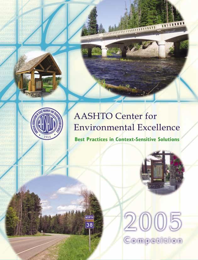
2 Best Practices in Context-Sensitive Solutions AASHTO s Center for Environmental Excellence is pleased to announce the winners of the 2005 Best Practices in Context-Sensitive Solutions (CSS) competition. AASHTO received 75 applications from 33 states. After careful review by a diverse expert review panel, three winners and seven notable practices were selected from across the United States. These winning transportation projects, programs, and initiatives demonstrate exemplary efforts in CSS that will serve as models for achieving transportation solutions that fit the natural and human environment while achieving mobility and safety goals and enhancing community values. CRITERIA The review panel judged each application based on the following criteria: Addressing transportation needs using CSS principles and effectively using resources; Use of partnering, collaboration, and multi-disciplinary approaches; Incorporation of community values and improving community assets; Achieving compatibility with the natural and built environment; and Measuring effectiveness in meeting CSS goals. CATEGORIES Winners were selected in each of three categories: Institutionalization or Organizational Change: Efforts made to make permanent the changes in attitudes and organizational structures that help institutionalize CSS practices in the agency s program of activities. Program Approaches: Organizational policies and programs that illustrate CSS principles throughout a program or function, applying to multiple projects. Project-Oriented Activities: Collaborative efforts to plan, design, construct, operate, and maintain a major project that reflects CSS principles. WINNERS Best Institutional Change New York State Department of Transportation Context Sensitive Solutions Implementation Initiative Best Program Oregon Transportation Investment Act (OTIA) State Bridge Delivery Program Part of the Edge of the Wilderness National Scenic Byway Corridor, this contextsensitive bridge reconstruction over Minnesota s Big Fork River applies rustic-style architectural and multimodal streetscape enhancements within the community. Photo Credit: Mn/DOT, Neil Kveberg. Best Project Minnesota TH 38, Edge of the Wilderness National Scenic Byway Corridor NOTABLE PRACTICES SR 179 Needs Based Implementation Plan Arizona DOT Highway 1 Median Barrier Project California DOT Berthoud Pass Mountain Access Project Colorado DOT Stormwater Management Visual and Environmental Quality and Safety Program Maryland State Highway Administration US 131 S-Curve Replacement Project Michigan DOT I-580 Freeway Extension Project Nevada DOT Institutionalization of CSS Utah DOT EXPERT REVIEW PANEL Kathy Ames, Illinois Department of Transportation Janet D Ignazio, Center for Transportation and the Environment, N.C. State University Eleanor Huber, Maryland State Highway Administration John Mettille, Kentucky Transportation Cabinet Sally Oldham, Oldham Historic Properties, Inc., Portland, Maine Harold Peaks, Federal Highway Administration, Washington, D.C. Melisa Ridenour, Federal Highway Administration, Eastern Federal Lands Highway Division Joe Sanchez, New Mexico Department of Transportation Patrick Shea, National Park Service, Denver, Colorado Shaun Van Doren, Township of Tewksbury Committeeman, Oldwick, New Jersey


3 Best Institutional or Organizational Change New York State DOT CSS Implementation Initiative CSS is not a separate process or set of standards. CSS is a philosophy that guides NYSDOT in all phases of project development, from planning through project scoping, design, and into construction and maintenance. CSS strives for outcomes that meet transportation service and safety needs, as well as environmental, scenic, aesthetic, cultural, natural resource, and community needs. Context-sensitive projects recognize community goals, and are planned, scoped, designed, built, and maintained while minimizing disruption to the community and the environment. New York State DOT Engineering Instruction At the New York State Department of Transportation (NYSDOT), context-sensitive solutions (CSS) represent more than a philosophy; CSS is a way of doing business. NYSDOT is committed to improve the process by which it delivers projects and services, including a comprehensive effort to incorporate CSS into its business practices. Beginning in 1999, the agency assembled a multi-disciplined CSS team to advance the philosophy throughout the department. The results can be seen in a range of policies and practices that are instilling CSS principles throughout the agency, ensuring that transportation solutions meet community needs and fit within their context. Efforts include adoption of Engineering Instruction , a policy document specifying that NYSDOT projects will reflect the principles of CSS and incorporate public involvement plans. The document sets forth the principles of CSS as they apply to projects in the state, and establishes CSS goals specifying that the state s projects should: Be in harmony with the community and preserve or improve the environmental, scenic, cultural, natural resources, and economic viability of the area. Address both transportation and community needs as developed by a full range of stakeholders. Incorporate early and effective public involvement. Identify and address community issues through a continuous, structured format. Incorporate innovative and safe solutions that add value for the user and the community. Be designed, built, and maintained with minimal disruption to the community. The CSS philosophy is also advanced within NYSDOT through an annual CSS award to recognize exemplary projects and share best practices; a CSS website with links to resources, best practices, and agency contacts; numerous CSS training courses; and incorporation of CSS into the agency s Project Development Manual, including a separate Public Involvement Manual. Context-sensitive solutions will continue as a part of NYSDOT s business processes through ongoing incentives and performance measures that will track progress in meeting CSS goals. Officials host a public information meeting to discuss reconstruction of NYS Routes 173 and 91, in the Town of DeWitt, NY. Citizens get involved in plans to reconstruct NYS Route 146 at a public information meeting in the Village of Altamont, NY. The Court Street Bridge replacement, located in Owego, NY, was a winner of the state's 2004 CSS Exemplary Project Award.


 developed an unprecedented bridge repair and replacement program, including a")
4 Best Program Oregon Transportation Investment Act (OTIA) State Bridge Delivery Program Using the Context Sensitive and Sustainable Solutions (CS3) approach for implementing the bridge program results in transportation solutions that reflect social values, maintain safety and mobility, support economic prosperity, achieve responsible stewardship of the natural environment, and optimize long-term performance of the state s transportation system. In essence, the bridge program enhances the quality of life for all Oregonians. Oregon Department of Transportation To the left: Located in the Rogue River National Forest, the Rogue River Bridge is one of more than 300 bridges being repaired or replaced in a context-sensitive manner under Oregon's progressive OTIA III State Bridge Delivery Program. Faced with the need to repair over 300 state highway bridges, the Oregon Department of Transportation (ODOT) developed an unprecedented bridge repair and replacement program, including a context-sensitive solutions approach to address transportation goals as well as community and quality-oflife goals for the citizens the state. Under the 2003 Oregon Transportation Investment Act (OTIA), the State Legislature provided $1.3 billion to repair or replace the aging highway bridges over the next eight to ten years. In order to complete the project in the timeframe mandated by the Legislature, ODOT developed the OTIA III State Bridge Delivery Program. The innovative program includes a collaborative permit-streamlining effort, in which ODOT obtained a programmatic permit for the entire bridge program instead of individual permits for each bridge. The program will be implemented using a newly developed Context Sensitive and Sustainable Solutions (CS 3 ) approach. According to ODOT, CS 3 is a decisionmaking framework that will focus on community values to shape a new generation of bridges. CS 3 combines the existing CSS design philosophy with the concept of sustainability, an approach that is unique to ODOT. The CS 3 approach will allow ODOT to achieve the goals of the bridge delivery program: maintaining mobility; stimulating Oregon s economy; employing efficient and cost-effective delivery practices; building projects that are sensitive to their communities and landscape; and capitalizing on funding opportunities. To the left: The bridge program is committed to employing a diverse workforce and stimulating Oregon's economy while being responsive and sensitive to the environment. CS 3 merges eight diverse disciplines under one umbrella: economic stimulus, diversity, cost-effectiveness, mobility, public involvement, environmental justice, environmental program management, and sustainability. A task lead manager is responsible for integrating these diverse management systems with ODOT s existing project delivery structure. As of April 2005, 50 bridges were in construction and 52 were in design. Construction will continue through The CS 3 approach is critical to delivering these bridge projects on time and within budget, while also meeting community and environmental goals. Implementing CS 3 will enable ODOT and Oregon s communities to create legacy bridges that will enhance quality of life for all Oregonians.


5 Best Project Minnesota Trunk Highway 38, Edge of the Wilderness National Scenic Byway Corridor With early engagement and listening, Mn/DOT used broad public and stakeholder involvement to better inform the understanding of context and the determination of purpose and need for proposed improvement projects along the TH 38 corridor. Consequently, and in applying all of the key principles of CSS advocated by the agency, Mn/DOT demonstrated flexibility in design to tailor and focus solutions and improvements where the public placed the highest values and received the most return or value-added for the investments. Minnesota Department of Transportation The 47-mile Minnesota Trunk Highway 38 (TH 38) Edge of the Wilderness National Scenic Byway Corridor weaves around lakes and wetlands, allowing travelers to experience Minnesota s northern woods. Faced with the need to reconstruct the aging highway, the Minnesota Department of Transportation (Mn/DOT) developed partnership alliances with Federal, state, and local stakeholders to guide the planning, scoping, and design process associated with the corridor. The resulting corridor reconstruction project exemplifies context-sensitive solutions, balancing safety, mobility, environmental, and community values. Trunk Highway 38, which runs through the Chippewa National Forest, was originally developed in the 1920s to replace a parallel logging railroad. Mn/DOT sought to reconstruct the substandard roadway to enhance safety and efficiency in the early 1990s. Mn/DOT initially assumed that flattening and straightening out the road consistent with higher design speeds would be crucial to the logging industry, the major employer using the corridor. But extensive outreach to the industry, the public, and agency partners produced a better solution. The consensus transportation solution focused on maintaining the two-lane roadway and existing alignment, incorporating spot upgrades where needed for safety improvements. This significantly reduced the amount of vegetation that needed to be cleared. The project incorporated four-foot paved shoulders with a rumble strip and an additional two feet of reinforced soft shoulder to improve safety and accommodate bicyclists, while reducing the roadway impacts on the land. The public and interagency working groups strived to develop solutions, not only for the transportation system, but also for managing land adjacent to the highway. The effort resulted in a completely coordinated schedule of improvement projects for the whole corridor, including transportation, recreation, water quality, and economic development. A variety of funding sources were used to incorporate context-sensitive features and interpretive sites along the corridor, including turnouts, rest areas, boat access sites, parallel trails, and sidewalk and streetscape enhancements. The improvements have contributed to significantly reduced accidents, enhanced mobility, greatly reduced cost, and context-sensitive outcomes all well ahead of schedule. Computer Visualization study exploring flexibility in design of the roadway cross-section to achieve context-sensitive roadway improvements. Photo & Visualization Credit: SEH, Mike Fraser. Computer Visualization study exploring flexibility in design of the roadway cross-section to achieve context-sensitive roadway improvements. Photo & Visualization Credit: SHE, Mike Fraser. This corridor interpretive park and trailhead site along the Byway links users to a multi-use trail that crosses the river and links to other area trail systems. Photo Credit: Mn/DOT, Neil Kveberg.

6 Context-sensitive solutions (CSS) consider the total context within which a transportation improvement project will exist. CSS is a collaborative, interdisciplinary approach that involves all stakeholders to develop a transportation facility that fits its physical setting and preserves scenic, aesthetic, historic, and environmental resources, while maintaining safety and mobility. This competition showcases outstanding examples of the work being done throughout the country to integrate CSS principles with the planning and delivery of transportation projects, programs, and services. The award winners and notable practices demonstrate how transportation agencies and their partners, working with their communities, can succeed in meeting mobility needs while promoting community values and enhancing the social and environmental context in which transportation facilities co-exist. MN TH 38 Edge of the Wilderness National Scenic Byway Corridor. Reconstruction of Minnesota s Edge of the Wilderness National Scenic Byway Corridor includes four-foot paved shoulders with rumble strips, additional reinforced soft shoulder, shallow ditch bottoms and steeper back-slopes to minimize adverse environmental and visual impacts. Photo Credit: Mn/DOT, Neil Kveberg Photo Captions for Front Cover, going top to bottom American Association of State Highway and Transportation Officials Center for Environmental Excellence 444 North Capitol Street, NW Washington, DC environment.transportation.org 1. The Rogue River Bridge is one of more than 300 bridges being repaired or replaced in a context-sensitive manner under Oregon s progressive OTIA III State Bridge Delivery Program. 2. A typical limited-use wayside rest area with information kiosk is one of the features of Minnesota s Edge of the Wilderness National Scenic Byway Corridor. Photo Credit: Mn/DOT, Neil Kveberg 3. A community/byway "gateway" instills a sense of place and pride along Minnesota s Edge of the Wilderness National Scenic Byway Corridor. Photo Credit: Mn/DOT, Karl Weissenborn 4. Minnesota s Edge of the Wilderness National Scenic Byway Corridor was reconstructed as a 10-ton, 2-lane roadway in a context-sensitive manner, using existing alignment with 4-foot paved shoulders and rumble strips, plus a 2-foot reinforced soft shoulder. Photo: Credit: Mn/DOT, Neil Kveberg
Cover photos Counter-clockwise from top: 1. View of Maryland State Highway Administration stormwater management facility after retrofitting. 2.
 Cover photos Counter-clockwise from top: 1. View of Maryland State Highway Administration stormwater management facility after retrofitting. 2. Utah DOT s 12300 South Project addresses transportation needs
Tricia Millington, RLA New York State Department of Transportation
 Tricia Millington, RLA New York State Department of Transportation pmillington@dot.state.ny.us Context Sensitive Principles: Context Sensitive Solutions is a philosophy wherein safe transportation solutions
2011 ASLA Design Awards. Top of the Rockies National Scenic and Historic Byway Merit Award Bluegreen. Planning & Urban Design
 2011 ASLA Design Awards Top of the Rockies National Scenic and Historic Byway Merit Award Bluegreen Planning & Urban Design ASLA Colorado 2011 Design Awards Category 2: Planning Project Fact Sheet Project
The Illinois Department of Transportation and Lake County Division of Transportation. Route 173, including the Millburn Bypass
 The Illinois Department of Transportation and Lake County Division of Transportation welcome you to this Public Hearing for U.S. Route 45 from Illinois Route 132 to Illinois Route 173, including the Millburn
Leveraging Cultural Heritage for Community Identity and Economic Development
 Leveraging Cultural Heritage for Community Identity and Economic Development Anne Ketz and Nathan Moe 106 Group, www.106group.com Introduction Heritage-based planning and design is an approach to community
Scope of Services. River Oaks Boulevard (SH 183) Corridor Master Plan
 Corridor Master Plan") Scope of Services River Oaks Boulevard (SH 183) Corridor Master Plan PROJECT AREA The project area consists of the River Oaks Boulevard (SH 183) corridor bounded by SH 199 at the northern end and the Trinity
Scope of Services River Oaks Boulevard (SH 183) Corridor Master Plan PROJECT AREA The project area consists of the River Oaks Boulevard (SH 183) corridor bounded by SH 199 at the northern end and the Trinity
Executive Summary. Parks and Recreation Plan. Executive Summary
 Parks and Recreation Plan Executive Summary The Whitemarsh Township Parks and Recreation Plan sets forth a vision for how Whitemarsh Township can provide a premiere parks and recreation system reflective
Lesson 6. Corridor Planning
 Lesson 6 Corridor Planning 1 Learning Outcomes Identify land use strategies and solutions that can be incorporated into multimodal transportation corridor plans Identify land use stakeholders and describe
Transportation Systems and Utility Infrastructure
 77 Audience Local and regional units of government, Landowners and developers, Community and citizen organizations, and Transportation/utility planners and engineers. Overview Transportation systems and
1.0 INTRODUCTION 1.1 TH 14 WEST STUDY AREA Project Description Functional Classification Purpose of the Project
 1.0 INTRODUCTION 1.1 TH 14 WEST STUDY AREA 1.1.1 Project Description The Trunk Highway (TH) 14 West Corridor is a two-lane roadway approximately 22 miles in length. Located in Nicollet County, the corridor
SCARBOROUGH SUBWAY EXTENSION. Scarborough Subway Extension. Final Terms of Reference
 Scarborough Subway Extension Final Terms of Reference 1 1.0 Introduction and Background 1.1 Introduction Toronto City Council recently confirmed support for an extension of the Bloor-Danforth Subway from
WELCOME TO THE CHOUTEAU GREENWAY DESIGN, DEVELOPMENT AND CONSTRUCTION WORKING GROUP!
 WELCOME TO THE CHOUTEAU GREENWAY DESIGN, DEVELOPMENT AND CONSTRUCTION WORKING GROUP! Chouteau Greenway Steering Committee and Working Groups Overview Overview January 9, 2019 Chouteau Greenway will transform
Executive Summary. NY 7 / NY 2 Corridor
 Executive Summary NY 7 / NY 2 Corridor Transportation and Land Use Study December 2005 Prepared for: Town of Colonie Capital District Transportation Committee Prepared by: Introduction: Land use decisions
FDOT D4 Complete Streets
 FDOT D4 Complete Streets Context Sensitive Solutions Directs that complete street solutions will complement the context of the community. Collaborative approach to decision making, project development,
Ann Arbor Downtown Street Design Manual. Ann Arbor DDA IDA 2015 Awards Planning Category
 Ann Arbor Downtown Street Design Manual Ann Arbor DDA IDA 2015 Awards Planning Category 1 Ann Arbor s downtown streets are vibrant public spaces that accommodate multi-modal transportation, special events,
Context Sensitive Solutions A Process to Achieve Better Results
 Context Sensitive Solutions A Process to Achieve Better Results Brian Bochner 1 Context Sensitive Solutions Collaborating with stakeholders to develop projects that meet their needs Stakeholders views
PROJECT BACKGROUND. Preliminary Design Scope and Tasks
 PROJECT BACKGROUND Preliminary Design Scope and Tasks The purpose of this Study is the development of preliminary designs for intersection improvements for Trunk Highway (TH) 36 at the intersections of
Route 347. New York State Department of Transportation Region 10, Long Island. THE GREENING of ROUTE 347
 The GREENING of Route 347 The Greening of Route 347 The Greening of Route 347: History 3 The Greening of Route 347 4 The Greening of Route 347 5 The Greening of Route 347 Smith Haven Mall 6 The Greening
Harlem Avenue Corridor Plan: Corridor Planning Across Municipal Boundaries
 Harlem Avenue Corridor Plan: Corridor Planning Across Municipal Boundaries Heather Tabbert, Manager, Local Planning and Programs Division Regional Transportation Authority (RTA) Jen McNeil Dhadwal, Principal
Washington Pass Overlook
 Washington Pass Overlook The Washington Pass Overlook is located on the Methow Valley Ranger District on the Okanogan-Wenatchee National Forest. The overlook is at the crest of Washington Pass and is part
Corridor Vision. 1Pursue Minnehaha-Hiawatha Community Works Project. Mission of Hennepin County Community Works Program
 1Pursue Minnehaha-Hiawatha Community Works Project Minnehaha-Hiawatha Community Works is a project within the Hennepin Community Works (HCW) program. The mission of the HCW program is to enhance how the
CHAPTER 1 Introduction
 CHAPTER 1 Introduction From sea to summit, Lane County covers almost 4,800 square miles of diverse Oregon landscape. Stretching from the Pacific Ocean through the Coastal Range, the Willamette Valley to
The Community and Transportation Linkage Planning Program
 The Community and Transportation Linkage Planning Program Sandy Misiewicz, AICP Capital District Transportation Committee Senior Transportation Planner II CSS National Dialog 2 October 1, 2013 Capital
ARLINGTON COUNTY, VIRGINIA. County Board Agenda Item Meeting of January 28, 2017 SUPPLEMENTAL REPORT
 ARLINGTON COUNTY, VIRGINIA County Board Agenda Item Meeting of January 28, 2017 SUPPLEMENTAL REPORT DATE: January 26, 2017 SUBJECT: The Virginia Department of Transportation s Transform I-66 Inside the
Parks Master Plan Implementation: Phase I Waterfront Use and Design REPORT #: September 7, 2016 File #
 0 'O DI Lan-171-14 1 - THE CORPORATION OF THE TOWN OF COBOURG..,. STAFF REPORT TO: FROM: Mayor and Members of Council Dean A. Hustwick, Director of Recreation and Culture DATE OF MEETING: Committee of
NASSAU COUNTY TOWN HALL NEW YORK & CONNECTICUT SUSTAINABLE COMMUNITIES. A Unique Bi-State Partnership to Improve Jobs, Housing and Transportation
 NASSAU COUNTY TOWN HALL NEW YORK & CONNECTICUT SUSTAINABLE COMMUNITIES A Unique Bi-State Partnership to Improve Jobs, Housing and Transportation Police Headquarters Auditorium Mineola, NY December 9 th,
Town of Peru Comprehensive Plan Executive Summary
 Town of Peru Comprehensive Plan Executive Communities that plan grow by choice, not by chance. A plan makes growth thoughtful, understandable, and predictable. A plan shows that a community is managing
1 Introduction. Chapter. In this chapter:
 Chapter 1 Introduction In this chapter: 1.1 A Snapshot of the Region 1.2 Towards a Sustainable Region 1.3 The Provincial Context 1.4 Purpose and Organization The Regional Municipality of York Official
ARLINGTON COUNTY, VIRGINIA. County Board Agenda Item Meeting of January 28, 2017 SUPPLEMENTAL REPORT-2
 ARLINGTON COUNTY, VIRGINIA County Board Agenda Item Meeting of January 28, 2017 SUPPLEMENTAL REPORT-2 DATE: January 27, 2017 SUBJECT: The Virginia Department of Transportation s Transform I-66 Inside the
Purpose of the Master Plan
 Purpose of the Master Plan 4 Master Plan Purpose The Master Plan is a policy framework for decisions that affect the physical, social and economic environment of the Town. The Parker 2035: Master Plan
Mendota Heights 2040 Comprehensive Plan Draft Vers
 4 Parks and Trails The City of Mendota Heights boasts a variety of recreational and open space opportunities. Few cities can claim access to regional trails, riverside and lakeside parks, scenic bluffs
Illiana Corridor CPG/TTF Meeting #1
 Illiana Corridor CPG/TTF #1 March 14, 2013 #10 1 Agenda Tier One Recap What happens in Tier Two? Tier Two Purpose and Need Identify Range of Alternatives Landowner Outreach Initial Context Sensitive Solution
July 12, Columbus City Council City Hall 90 West Broad Street Columbus, OH RE: I-70/71 Columbus Crossroads Project
 OHIO DEPARTMENT OF TRANSPORTATION DISTRICT 6 400 EAST WILLIAM STREET DELAWARE, OHIO 43015 800.372.7714 Columbus City Council City Hall 90 West Broad Street Columbus, OH 43215-9015 RE: I-70/71 Columbus
3. VISION AND GOALS. Vision Statement. Goals, Objectives and Policies
 Vision Statement Queen Creek s interconnected network of parks, trails, open spaces and recreation opportunities provide safe and diverse activities and programs that sustain its unique, small town, equestrian
Creating Complete Roadway Corridors:
 Creating Complete Roadway Corridors: The AASHTO Guide to Transportation Landscape Architecture and Environmental Design NCHRP Project 15-33 Status Report AASHTO Standing Committee on Design Technical Committee
Comprehensive Plan ADOPTED APRIL 2014
 Comprehensive Plan ADOPTED APRIL 2014 8 8. Outstanding Recreational & Cultural Opportunities We are proud of our community s parks and recreation system. Our community will ensure that the legacy of our
Planning Roles. Responsibilities
 Lesson 3 Planning Roles & Responsibilities 3-1 Learning Outcomes Identify and describe transportation and land use planning processes Describe the relationships among these processes and how they can be
T H A T E V E R Y O N E
 B R I N G I N G C H A N G E T H A T E V E R Y O N E C A N F E E L. AT CHW, we survey, plan, design, engineer, administer and inspect with a purpose: to positively transform the communities we serve. From
Hockessin Community Redevelopment Plan
 Hockessin Community Redevelopment Plan 3.1 Introduction The Community Redevelopment Plan for the Village of Hockessin is the result of the people s vision for a distinct village center that serves as the
Purpose of the Master Plan
 Purpose of the Master Plan 4 Master Plan Purpose The Master Plan is a policy framework for decisions that affect the physical, social and economic environment of the Town. The Parker 2035: Master Plan
Achieving Regional Metropolitan Area Nature Conservation: Ingredients for Success
 Achieving Regional Metropolitan Area Nature Conservation: Ingredients for Success Presentation to the 2015 George Wright Society Conference Lynn Wilson, MCIP RPP March 31, 2015 Outline The challenge of
Streets for People, Place-Making and Prosperity. #TOcompletestreets
 COMPLETE STREETS FOR TORONTO Streets for People, Place-Making and Prosperity COMPLETE STREETS: A NEW APPROACH A Complete Streets design approach considers the needs of all users people who walk, bicycle,
Highway & Bridge Capabilities
 Highway & Bridge Capabilities Part of a diversified family of solutions www.jmt.com An Employee Owned Company I-95/I-295/I-495 Interchange, Woodrow Wilson Memorial Bridge, Prince George s County, MD Our
implementation r expression in landscape
 6 ubc okanagan implementation campus plan r expression in landscape 68 6 implementation campus plan sections The Campus Plan supports the academic mission, values and commitments of the University by providing
Transportation Land Use Integration & Regional Planning. Don Kostelec, AICP Senior Planner, Louis Berger Group February 1, 2010
 Transportation Land Use Integration & Regional Planning Don Kostelec, AICP Senior Planner, Louis Berger Group February 1, 2010 Transportation Land Use Integration DOT-HUD-EPA Sustainable Communities Initiative
Potential Green Infrastructure Strategies May 6, 2015 Workshop
 Potential Green Infrastructure Strategies May 6, 2015 Workshop Background The City of Cortland is developing the Tioughnioga Urban Headwaters Green Infrastructure Action Plan with funding from the National
1.0 Circulation Element
 5/9/18 1.0 Circulation Element 1.1 Introduction As growth and development occur in Apache County, enhancements to its circulation system will be necessary. With time, more roads will be paved and air and
WELCOME TO THE CHOUTEAU GREENWAY ECONOMIC DEVELOPMENT WORKING GROUP!
 WELCOME TO THE CHOUTEAU GREENWAY ECONOMIC DEVELOPMENT WORKING GROUP! Chouteau Greenway Steering Committee and Working Groups Overview Overview January 9, 2019 Chouteau Greenway will transform St. Louis
Preliminary Plan Framework: Vision and Goals
 Preliminary Plan Framework: Vision and Goals Draft: May 2015 Introduction Since the Town of Milliken s comprehensive plan was last updated in 2010, the community was heavily impacted by the 2013 flood,
Complete Streets in Lancaster County
 Complete Streets in Lancaster County PRESENTED BY: Robert Bini, AICP Director for Transportation Planning November 14, 2017 Lancaster County is a growing county of over 534,000 and the bottom line is...
REQUEST FOR QUALIFICATIONS
 REQUEST FOR QUALIFICATIONS VILLAGE OF HAMBURG COMPREHENSIVE ZONING/LAND USE REGULATIONS UPDATE Prepared By: Village of Hamburg 100 Main Street Hamburg, New York 14075 Village of Hamburg RFQ Page 1 of 10
Workshop on Practice & Research in Urban Sustainability Assessment
 Workshop on Practice & Research in Urban Sustainability Assessment August 17-18, 2016 Tokyo International Assn for Impact Assessment Japan Branch Global Carbon Project Tsukuba International Office Japan
RESILIENT COMMUNITIES PROJECT CITY OF MINNETONKA
 RESILIENT COMMUNITIES PROJECT CITY OF MINNETONKA BUILDING COMMUNITY-UNIVERSITY PARTNERSHIPS FOR SUSTAINABILITY Presentation to The League of Women Voters March 16, 2013 Julie Wischnack, Community Development
4.1 AESTHETICS AND VISUAL QUALITY
 SCOPE AND METHODOLOGY 4.1 AESTHETICS AND VISUAL QUALITY This section evaluates the potential impacts to aesthetics and visual quality. Aesthetics refers to visual resources and the quality of what can
The Palisades Interstate Parkway and Henry Hudson Drive designated a New Jersey State Scenic Byway, 2005
 The Palisades Interstate Parkway and Henry Hudson Drive designated a New Jersey State Scenic Byway, 2005 What are scenic byways? How Did Scenic Byways Come About? National Scenic Byways Program Administered
Implementation Guide Comprehensive Plan City of Allen
 Implementation Guide 2030 Comprehensive Plan City of Allen DRAFT 2015 Implementation Guide Allen 2030 Comprehensive Plan INTRODUCTION The Comprehensive Plan serves as a guide for the growth and development
Municipal Development Plan 2013
 UNIQUELY STONY PLAIN: Municipal Development Plan 2013 Quick Reference Guide What is a Municipal Development Plan (MDP)? The Town s highest-level planning document Sets the long-term vision and key themes
Envision Sustainable Infrastructure
 Envision Sustainable Infrastructure Marshview Park Allyson Monsour, PE, ENV SP, LEED Green Associate What Is Sustainability? Social Sustainability Fair and beneficial labor practices Community involvement
Downtown Dubuque...it s a great time.
 Downtown Dubuque...it s a great time. Your timing could not be better to invest in Downtown. With hundreds of millions in public and private investment occurring on the City s downtown waterfront, millions
Small Area Plan. South Gateway
 Small Area Plan Adopted May 12, 2008 South Gateway Purpose. The South Gateway Small Area Plan defines the City s expectations for the future of the southern entrance to the City at Interstate 85 and Highway
IDENTIFYING, EVALUATING, AND PRESERVING MINNESOTA'S HISTORIC ROADSIDE FACILITIES
 IDENTIFYING, EVALUATING, AND PRESERVING MINNESOTA'S HISTORIC ROADSIDE FACILITIES Overview Minnesota built many wayside rest areas during 1930s & '40s (New Deal-WPA, CCC) Many are now threatened Limited
Best Practices in Smart Growth and Transportation
 Best Practices in Smart Growth and Transportation 2004 COMPETITION Cover art Revitalizing Communities and Corridors Creating Statewide Strategies for Land Use and Transportation American Association Of
2011 ASLA Design Awards
 2011 ASLA Design Awards Interstate 70 Mountain Corridor Aesthetic Guidance Honor Award Design Workshop, Aspen / THK Associates, Inc. / CH2MHill Planning and Urban Design Project Title: Interstate70 Mountain
About Momentum Midland
 About Momentum Midland Achieving a community s full potential in terms of economic development and quality of life is critically important to its long term sustainability. Core to achieving this is a vibrant
SH 199 Corridor Master Plan. Community Meeting No. 2 May 31, 2017
 Community Meeting No. 2 May 31, 2017 Transportation Projects On or Near SH 199 SH 199 from 0.3 miles south of FM 1886 to south end of Lake Worth bridge Construct freeway mainlanes and frontage roads 10-Year
I. STAFF POLICY RECOMMENDATIONS. The following RMP policy strategies are proposed by staff in support of a Scenic Resource Protection Program:
 Policy Consideration: Scenic Resource Protection Program Status: For Consideration by the Highlands Council at September 14, 2006 Work session Date: September 12, 2006 I. STAFF POLICY RECOMMENDATIONS The
The transportation system in a community is an
 7 TRANSPORTATION The transportation system in a community is an important factor contributing to the quality of life of the residents. Without a sound transportation system to bring both goods and patrons
Supporting our communities. Bridges
 Supporting our communities Bridges 1,000+ We ve partnered with thousands of owners/clients to inspect, analyze, design, and manage their bridges, providing lasting community connections. We design bridges
V. Vision and Guiding Principles
 V. Vision and Guiding Principles The Master Plan for the Powers Ferry Corridor seeks a foundation in the desires of the community. At times, various elements of the community offered opposing viewpoints,
7Page 91 CLEMMONS COMMUNITY COMPASS 7 COMMUNITY CHARACTER
 7 Community Character The beauty of Clemmons won t necessarily be a reflection of our past, but our future. This quote from Comprehensive Plan Steering Committee member Wayne Dodson captures the essence
Working together to leverage limited Funds
 Working together to leverage limited Funds ARAPAHOE COUNTY OPEN SPACES 10 County Budget Conference September 20, 2013 The Power of Partnerships 2013 SORP Conference 5/23/2014 Why Talk About Open Space?
COMMUNITY DESIGN. GOAL: Create livable and attractive communities. Intent
 COMMUNITY DESIGN Intent An attractive, well-designed County will attract quality development, instill civic pride, improve the visual character of the community, and create a strong, positive image for
LPC Goals and Strategies. Transportation and Connectivity Employment Opportunities Food Access Waterfront Access Livable Communities
 LPC Goals and Transportation and Connectivity Employment Opportunities Food Access Waterfront Access Livable Communities Transportation and Connectivity Goal: Safe and ready access of all types allowing
Illustration of Eastlake Farmer s Cooperative Grain Elevator. Chapter 5: implementation 5-1
 Illustration of Eastlake Farmer s Cooperative Grain Elevator Chapter 5: implementation 5-1 chapter 5: implementation Introduction The Eastlake Subarea Plan includes a wide range of recommendations intended
CHAPTER 8 ISSUES, CONCERNS, CONSTRAINTS AND OPPORTUNITIES
 CHAPTER 8 ISSUES, CONCERNS, CONSTRAINTS AND OPPORTUNITIES Introduction This River Conservation Plan was developed during a time of tremendous activity and effort in planning the transformation of the Delaware
CITY COUNCIL AGENDA REPORT
 CITY COUNCIL AGENDA REPORT Subject: COUNCIL MOTION LRT ALIGNMENT REMOVAL FROM THE TRANSPORTATION MASTER PLAN On February 10, 2016 Councillor Hughes provided notice in accordance with Section 23 of Procedure
WELCOME TO THE CHOUTEAU GREENWAY EQUITY WORKING GROUP!
 WELCOME TO THE CHOUTEAU GREENWAY EQUITY WORKING GROUP! Chouteau Greenway Steering Committee and Working Groups Overview Overview January 9, 2019 Chouteau Greenway will transform St. Louis by connecting
LEADERS IN OUTDOOR MAINTENANCE. Timely performance with technical competence
 Company Profile LEADERS IN OUTDOOR MAINTENANCE Timely performance with technical competence Introduction Terracare Associates, LLC is a recognized leader in outdoor maintenance and has been proudly serving
I-70 Corridor Enhancement Plan
 i - Table of Contents Table of Contents Chapter I Overview Chapter II Bridge and Roadway Improvements Chapter III Landscape Enhancements Chapter IV Riparian Corridors Chapter V Showcase Missouri Plan Chapter
Town of Oakville Streetscape Strategy
 Town of Oakville Streetscape Strategy Endorsed by PDC on February 10, 2014 (PD-011-14) Town of Oakville Streetscape Strategy [endorsed by PDC February 10, 2014] 0 Town of Oakville Streetscape Strategy
Benchmark Nonpoint Source Management Approaches In Other States
 Governor s Environmental Advisory Council 2007 Nonpoint Source Pollution Control Initiative Benchmark Nonpoint Source Management Approaches In Other States Governor s Environmental Advisory Council April
Regional Sustainability: Planning, Implementation, and Measurement
 Regional Sustainability: Planning, Implementation, and Measurement Carissa Schively Slotterback, PhD, AICP Humphrey School of Public Affairs, University of Minnesota ULI Minnesota Lightening Our Footprint
Published in March 2005 by the. Ministry for the Environment. PO Box , Wellington, New Zealand ISBN: X.
 Action Pack Published in March 2005 by the Ministry for the Environment Manatū Mō Te Taiao PO Box 10-362, Wellington, New Zealand ISBN: 0-478-18994-X ME number: 580 This document is available on the Ministry
VILLAGE OF ROMEOVILLE
 VILLAGE OF ROMEOVILLE COMPREHENSIVE PLAN FRAMEWORK PLAN, KEY STRATEGIES & GUIDING PRINCIPLES December 8, 2016 KEY PLANNING THEMES 2 KEY PLANNING THEME #1 ADVANCING A BALANCED ECONOMIC BASE KEY PLANNING
Fairfax Boulevard Complete Street
 Fairfax Boulevard Complete Street 100 Plus Year Vision We are a Bedroom Community. A Decade-Long Partnership Charles Town- Ranson Commerce Corridor Council launched in 1999. Consisted of local/state/federal
2040 LUP is a part of the Comprehensive Plan and carries the same legal authority. Economic Challenges
 1.1. Guiding Anchorage s Growth Where will new residents settle over the next two decades? Where will people work, shop, and play? Will there be enough room to grow? How will Anchorage look? Will growth
CITY VIEW OBJECTIVES
 SECTION 2: CITY VIEW OBJECTIVES CONTENTS 2.1 Introduction 1 2.2 Strategic Direction 1 2.3 The City View Resource Management Issues for the City 1 2.4 The Goal 3 2.5 The City View Objectives 3 Palmerston
ITEM #8. Regional Smart Growth Program. Regional Smart Growth Program. Presentation Overview. Coast Highway Vision and Stategic Plan.
 Regional Smart Growth Program Economic Development Commission What is Smart Growth? Adopted as part of the Regional Comprehensive Plan (RCP) RCP provides vision for region based on Smart Growth and sustainability
D-O LRT Zoning Discussion. Chapel Hill Boards & Commissions October 16, 2017
 D-O LRT Zoning Discussion Chapel Hill Boards & Commissions October 16, 2017 Update on Overall D-O LRT Station Area Initiative Objectives Design and educate on principles of Good Transit-Oriented Development
City of Tacoma Planning and Development Services
 Agenda Item D-1 City of Tacoma Planning and Development Services To: Planning Commission From: Elliott Barnett, Planning Services Division Subject: Application #2014-08 Open Space Element Update Meeting
CHAPTER 7: Transportation, Mobility and Circulation
 AGLE AREA COMMUNITY Plan CHAPTER 7 CHAPTER 7: Transportation, Mobility and Circulation Transportation, Mobility and Circulation The purpose of the Transportation, Mobility and Circulation Chapter is to
CITY OF CHARLOTTESVILLE, VIRGINIA CITY COUNCIL AGENDA
 CITY OF CHARLOTTESVILLE, VIRGINIA CITY COUNCIL AGENDA Agenda Date: December 16, 2013 Action Required: Adoption of Resolution Presenter: Staff Contacts: Title: James E. Tolbert, AICP, Director of NDS James
Plan Overview. Manhattan Area 2035 Reflections and Progress. Chapter 1: Introduction. Background
 Plan Overview The Manhattan Urban Area Comprehensive Plan (the Comprehensive Plan) is a joint planning initiative of the City of Manhattan, Pottawatomie County, and Riley County. The 2014 Comprehensive
AASHTO Center For Environmental Excellence
 Cover photos Left to right: 1. Kentucky s Pine Mountain: The new road design helps to soften the road s dangerous curves and widens shoulders to provide added safety. 2. Kentucky: Pine Mountain is home
Trail Feasibility and Planning Project for Northern Dutchess County, New York
 for Northern Dutchess County, New York Funded in Part by Grants from the Hudson River Valley Greenway, Land Trust Alliance Conservation Partnership Program and the Thomas Thompson Trust 1 STEERING COMMITTEE
Regional Economic Development Councils & The Consolidated Funding Application. Khris Dodson SU-EFC
 Regional Economic Development Councils & The Consolidated Funding Application Khris Dodson SU-EFC REDCs and You Each Region created a strategic plan. Strategic goals to improve economy: 1. Strengthen
East Bench Master Plan Update
 Community & Economic Development Office of the Director East Bench Master Plan Update To: From: Planning Commission Wayne Mills, Senior Planner Date: November 18, 2015 CC: Re: Nora Shepard, City Planning
The Five Components of the McLoughlin Area Plan
 The Five Components of the McLoughlin Area Plan This documents contains the complete language of the five components of the McLoughlin Area Plan: The Vision Statement The Values The Guiding Principles
TRANSPORTATION ELEMENT
 TRANSPORTATION ELEMENT GOAL I: To create and maintain a safe, efficient and aesthetic transportation system that encourages multi-modal transportation and promotes the mobility strategies of the Ocala
Presented by Meg Parker Public Health Outreach Coordinator
 Presented by Meg Parker Public Health Outreach Coordinator Essex County Public Health Creating Healthy Places (grant funded program from New York State Department of Health) Three learning objectives List