IDENTIFYING, EVALUATING, AND PRESERVING MINNESOTA'S HISTORIC ROADSIDE FACILITIES
|
|
|
- Lily Wilkerson
- 5 years ago
- Views:
Transcription
1 IDENTIFYING, EVALUATING, AND PRESERVING MINNESOTA'S HISTORIC ROADSIDE FACILITIES
2 Overview Minnesota built many wayside rest areas during 1930s & '40s (New Deal-WPA, CCC) Many are now threatened Limited knowledge of waysides Developed inventory of Mn/DOT properties & identified those eligible for the National Register of Historic Places (NRHP) Inventory 1 st phase of time & money-saving planning documents
3 Historical Background 1920s - auto tourism popular Roads were poor & few roadside amenities existed As result, modern highway design emerged: Increase highway safety & enhance tourism Included early planning, sound engineering, & landscaping Included roadside development facilities

4 1930s roadside development sketch Goals: safety & aesthetic qualities
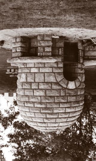
5 Roadside development facilities: Contain variety of features (43 types) Local materials often stone Designs blended with nature Roadside features are

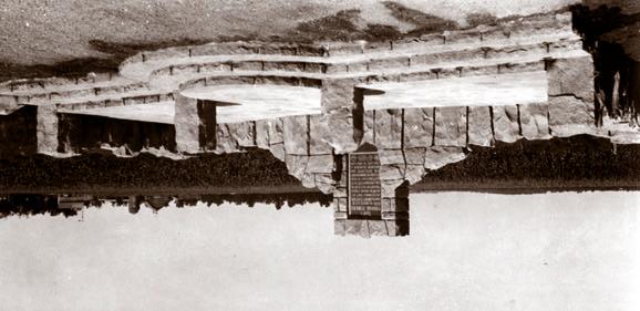
6 Scenic overlooks

7 Historic markers

8 Picnic areas
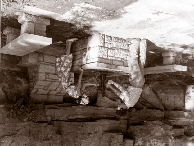
9 Fireplaces
10 Springs

11 Entry signs

12 And bridges

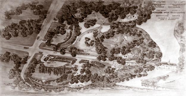
13 Popular tourism corridors sometimes included many facilities
14 Existing Conditions Mn/DOT recognized need to understand and centrally manage these waysides. Today, highway projects adversely affecting waysides through:
15 Widespread threats: Growing transportation demands Highway expansion Development pressures/land use changes Public s needs changed, yet little done to adapt facilities Improper repairs Vandalism Deterioration/neglect

16 For example, site use was diminished, maintenance & repairs were delayed; site is a victim of benign neglect
17 Assessment & Analysis Mn/DOT: Found few precedents to determine historical significance Discovered inventory was groundbreaking (one of 1st studies of its type in the U.S.)
18 Because little precedent existed, Mn/DOT developed a new historic context to understand the properties and evaluate their significance The new context developed as part of the inventory is Roadside Development on Minnesota Trunk Highways, Results of the inventory are
19 102 properties studied 51 properties & 1 district determined eligible under new context (about ½) Mn/DOT realized they own significant collection of roadside development facilities Additional planning documents
20 The inventory is: not only ambitious serves as a model for other state-level landscape survey initiatives Inventory was: Thorough Statewide Comparative (Charles Birnbaum of NPS's Historic Landscape Initiative)
21 Planning documents Additional documents will save time and money Management plan Programmatic agreement
22 Management plan will: provide preservation direction to staff allow for early planning decisions Allows Mn/DOT to better analyze alternatives & avoid or minimize adverse affects allow time to obtain restoration or maintenance funding help Mn/DOT invest wisely prevent benign neglect
23 Mgmt. plan includes: Treatment reports - 3 preservation levels + cost estimates (final 2003) 1.Stabilization (immediate/critical need) 2.Preservation 3.Restoration Priority ranking (statewide comparison) Comprehensive maintenance guidelines include: proper masonry repairs vegetation management plan And
24 District input List of properties to nominate for NRHP A "conservation zone" buffers historic property from elements that may distract/detract. Mn/DOT plans to restore the most significant properties, such as

25 Orr Roadside Parking Area already under construction (all work meets Sec. of Interior's Standards for Treatment of Historic Properties)
26 By studying these properties together, Mn/DOT saved money Individual National Registereligibility surveys Collective survey (per property).. Est. savings per property. Cost $5,000 -$1,866 $3,134
27 Estimated savings of approx. 40% per property $3,134 x 102 properties = $319,668
28 Mn/DOT plans to develop programmatic agreement with partner agencies (ex. FHWA, State Historic Preservation Office) Programmatic Agreement should: Establish preservation commitments Eliminate some external individual reviews Save time & money on individual reviews
29 Outreach & Education Mn/DOT realizes one of best preservation tools is communication - both with its staff and public As more people become aware of significance of these facilities, more efforts taken to preserve properties
30 District staff have inventory & report ( Database available to Mn/DOT on web All staff asked to consult Cultural Resources Unit before undertaking projects near the properties. District personnel participating in preservation planning documents
31 Other Mn/DOT initiatives: Participate in joint promotional efforts with tourism groups & historical societies. Develop program where local groups can "adopt" a historic wayside rest. Develop communication tools about historic roadside facilities. Install interpretive signs
32 An important item to note: Mn/DOT received Honor Award from Preservation Alliance of Minnesota (statewide non-profit preservation advocacy group). Award recognizes inventory report for innovation as planning document and honors Mn/DOT's stewardship
33 Summary Mn/DOT's roadside facilities study began as simple inventory & became a much more comprehensive undertaking. Mn/DOT is committed to responsibly caring for these properties so the traveling public can continue to experience their unique historic qualities.
34 Thank you
Identifying, Evaluating, and Preserving Minnesota's Historic Roadside Facilities
 Identifying, Evaluating, and Preserving Minnesota's Historic Roadside Facilities Liz Walton Minnesota Department of Transportation Office of Technical Support, MS 686 395 John Ireland Boulevard St. Paul,
Historic Asset Management A Decision Support Process for Balanced Consideration of Mission Utility, Historic Value, and Facility Condition
 Historic Asset Management A Decision Support Process for Balanced Consideration of Mission Utility, Historic Value, and Facility Condition Joe Lockerd; Cardno TEC Kurt Schweigert; Cardno TEC Adriane Fowler
Corridor Management Committee. September 29, 2017
 Corridor Management Committee September 29, 2017 1 Today s Topics Chair s Update Proposed Corridor Protection Wall Aesthetic Design Overview Public Outreach Environmental Review Civil Construction Update
FARMLAND PRESERVATION AND PUBLIC POLICY ISSUES
 FARMLAND PRESERVATION AND PUBLIC POLICY ISSUES Lancaster County, home to the richest, most productive agricultural soils in the country, faces a tough battle in efforts to preserve our home, our harvest,
Hunterdon County s Stone Arch Bridges
 Hunterdon County s Stone Arch Bridges Hunterdon County s interest in stone arch bridges began in 1992, when a developer wanted to a raze a stone arch bridge so that a road could be widened for a new development.
TH 169/1 1B 265 City/Township. Soudan, City of St. Louis Acres 3.5. Soudan Z15 E N Not Eligible, see Statement of Significance
 Historic Name CS # 6904 Other Name Pioneer Miners Memorial SHPO Inv # Location N side of TH 169/TH 1 2.4 mi E of TH 135 Hwy District Reference TH 169/1 1B 265 City/Township County Soudan, City of St. Louis
PROJECT BACKGROUND. Preliminary Design Scope and Tasks
 PROJECT BACKGROUND Preliminary Design Scope and Tasks The purpose of this Study is the development of preliminary designs for intersection improvements for Trunk Highway (TH) 36 at the intersections of
Connecting the DOTs: Nationwide Trends in the Inventory, Evaluation, and Management of Historic Roads
 Connecting the DOTs: Nationwide Trends in the Inventory, Evaluation, and Management of Historic Roads In 2013-2014 Mead & Hunt, Inc. surveyed state Departments of Transportation (DOTs) on how they address
MADRID MINING LANDSCAPE Western Planner/Nevada APA Conference. A New Mexico Abandoned Mine Land (AML) Program Community-Based Planning Project
 Program Community-Based Planning Project") MADRID MINING LANDSCAPE 2013 Western Planner/Nevada APA Conference A New Mexico Abandoned Mine Land (AML) Program Community-Based Planning Project Presented by: Ken Romig, ASLA Associate, Dekker/Perich/Sabatini
MADRID MINING LANDSCAPE 2013 Western Planner/Nevada APA Conference A New Mexico Abandoned Mine Land (AML) Program Community-Based Planning Project Presented by: Ken Romig, ASLA Associate, Dekker/Perich/Sabatini
HISTORIC PRESERVATION PLAN
 Delaware County HISTORIC PRESERVATION PLAN Monday, June 20, 2016 Delaware County Planning Department Preservation Plan Today s Agenda Need for a Comprehensive Plan (including Preservation) Planning Process
Re: Reevaluation of Statewide Historic Bridge Inventory - Comprehensive Look at Remaining Inventory
 March 7th, 2017 Sarah Clarke Cultural Resources Program Environmental Division Virginia Department of Transportation 1401 East Broad Street Richmond, Virginia 23219 Re: Reevaluation of Statewide Historic
Corridor Enhancements
 Corridor Enhancements Safety is MoDOT s first priority in widening and rebuilding I-70 across the state of Missouri. MoDOT also understands that the interstate - and its interchanges and overpasses - are
Eligible, see Statement of Significance. Roadside Development on Minnesota Trunk Highways,
 Historic Name CS # 0115 Other Name SHPO Inv # Location Both sides of TH 169 on isthmus between Little Pine Lake and Hickory Lake Hwy District Reference City/Township County Farm Island Township Aitkin
Cumberland County Preservation Opportunities Watch List 2018 Nominations
 Cumberland County Preservation Opportunities Watch List Information The Cumberland County Historical Society (CCHS) is designated as the official historical society of Cumberland County by its Commissioners.
Summary of Action Strategies
 Strategic Action Plan 6 Summary of Action Strategies Action Strategy Categories: 1. Organization and Management 2. Implementation 3. Marketing and Promotion This chapter summarizes all of the action strategies
I. STAFF POLICY RECOMMENDATIONS. The following RMP policy strategies are proposed by staff in support of a Scenic Resource Protection Program:
 Policy Consideration: Scenic Resource Protection Program Status: For Consideration by the Highlands Council at September 14, 2006 Work session Date: September 12, 2006 I. STAFF POLICY RECOMMENDATIONS The
Arlington, Virginia is a worldclass
 EXECUTIVE S U M M A RY Arlington maintains a rich variety of stable neighborhoods, quality schools and enlightened land use policies, and received the Environmental Protection Agency s highest award for
BEST PRACTICES FOR PROJECT NOMINATIONS TA Set-Aside Program
 BEST PRACTICES FOR PROJECT NOMINATIONS 2017 TA Set-Aside Program Focus of this presentation Photos Public Support Maps & Exhibits Proposed Budget Design Details Project Evaluation & Selection Criteria
Fredericksburg Historic Resources Survey
 Fredericksburg Historic Resources Survey MAY 2018 Presentation Overview Historic Resources Terminology Project Background Project Goals Project Approach Get Involved Historic Resources Terminology Historic
2018 WORK PLAN. Land Use & Ethics Training presented by: Assistant City Attorney, Natasha Zimmerman
 2018 WORK PLAN GOAL1: Improvements to Existing Codes and Processes The Historic Landmarks Commission and staff continue to work to ensure that the Historic Preservation Code reflects the policies within
Town of Peru Comprehensive Plan Executive Summary
 Town of Peru Comprehensive Plan Executive Communities that plan grow by choice, not by chance. A plan makes growth thoughtful, understandable, and predictable. A plan shows that a community is managing
Phase I Results. Minnesota Local Historic Bridge Study. Minnesota Department of Transportation. Bridge 448 in Olmsted County. Report prepared for
 Phase I Results Minnesota Local Historic Bridge Study Bridge 448 in Olmsted County Report prepared for Minnesota Department of Transportation Bridge L7075 in Todd County Report prepared by www.meadhunt.com
Congestion Management Safety Plan. Michael Corbett State Program Administrator September 2017
 Congestion Management Safety Plan Michael Corbett State Program Administrator September 2017 Agenda Topic 1 What is the Congestion Management Safety Plan (CMSP)? 2 Relevance to Congestion Investments 3
3. VISION AND GOALS. Vision Statement. Goals, Objectives and Policies
 Vision Statement Queen Creek s interconnected network of parks, trails, open spaces and recreation opportunities provide safe and diverse activities and programs that sustain its unique, small town, equestrian
CITY OF FARGO PARKING RAMP SITE EVALUATION
 CITY OF FARGO PARKING RAMP SITE EVALUATION EXECUTIVE SUMMARY Helenske Design Group (architect) and Carl Walker Inc (Parking Consultant) were retained by the City of Fargo to complete a downtown parking
AASHTO s Center for Environmental Excellence is pleased to announce the winners of the 2005 Best
 Best Practices in Context-Sensitive Solutions AASHTO s Center for Environmental Excellence is pleased to announce the winners of the 2005 Best Practices in Context-Sensitive Solutions (CSS) competition.
Mendota Heights 2040 Comprehensive Plan Draft Vers
 4 Parks and Trails The City of Mendota Heights boasts a variety of recreational and open space opportunities. Few cities can claim access to regional trails, riverside and lakeside parks, scenic bluffs
TH 59 8B 34.5 City/Township. Avoca Z15 E N Eligible, see Statement of Significance
 Historic Name CS # 5104 Other Name SHPO Inv # Location NE side of TH 59 about 400' SE of CSAH 6 Hwy District Reference TH 59 8B 34.5 City/Township County Avoca, City of Murray Acres 5 Twp Rng Sec 106N
Section IV. Impacts to Cultural Resources
 Section IV Impacts to Cultural Resources 83 Archaeological Sites and Traditional Cultural Properties. Specific resources were not identified in this edition of the Mount Spokane CRMP, and as a result no
STAFF RECOMMENDATION: Adopt the Parks and Recreation Master Plan 2013, or take other action as deemed appropriate.
 Regular 7. CITY COUNCIL AGENDA Meeting Date: 12/02/2013 TITLE: Parks and Recreation Master Plan 2013 Adoption Proposal - Dwight Curtis Responsible Staff: Dwight Curtis Backup Material: Backup material
PARTF Scoring System for Grants
 PARTF Scoring System for Grants The members of the N.C. Parks and Recreation Authority use the PARTF scoring system as one of several tools to select grant recipients. Please provide all of the information
PUBLIC SPACES MASTER PLAN UPDATE (POPS) Joint Facilities Advisory Commission (JFAC) November 28, 2018
 Joint Facilities Advisory Commission (JFAC) November 28, 2018") PUBLIC SPACES MASTER PLAN UPDATE (POPS) Joint Facilities Advisory Commission (JFAC) November 28, 2018 1 AGENDA POPS Planning Context Timeline Public Input Final POPS Draft Next Steps 2 PLANNING CONTEXT
PUBLIC SPACES MASTER PLAN UPDATE (POPS) Joint Facilities Advisory Commission (JFAC) November 28, 2018 1 AGENDA POPS Planning Context Timeline Public Input Final POPS Draft Next Steps 2 PLANNING CONTEXT
13 Extending the Esri Enterprise Licence Agreement
 Clause 13 in Report No. 10 of Committee of the Whole was adopted, without amendment, by the Council of The Regional Municipality of York at its meeting held on May 21, 2015. 13 Extending the Esri Enterprise
Illiana Corridor CPG/TTF Meeting #1
 Illiana Corridor CPG/TTF #1 March 14, 2013 #10 1 Agenda Tier One Recap What happens in Tier Two? Tier Two Purpose and Need Identify Range of Alternatives Landowner Outreach Initial Context Sensitive Solution
TABLE OF CONTENTS HISTORIC PRESERVATION ELEMENT I. INTRODUCTION HP. A. Purpose HP B. Assessment and Conclusions...
 TABLE OF CONTENTS HISTORIC PRESERVATION ELEMENT I. INTRODUCTION... 1 - HP A. Purpose... 1 - HP B. Assessment and Conclusions... 1 - HP II. GOAL, OBJECTIVES AND POLICIES... 3 - HP GOAL 1: PROTECTION AND
HISTORICAL AND ARCHAEOLOGICAL RESOURCES POLICIES
 HISTORICAL AND ARCHAEOLOGICAL RESOURCES POLICIES The County will: GOALS AND OBJECTIVES 5.1 Historic Resource Protection Protect historic resources for their historic, cultural, social and educational values
Photo Album Intact/Slightly Altered. Eligible, see Statement of Significance. Roadside Development on Minnesota Trunk Highways,
 Historic Name CS # 8607 Other Name SHPO Inv # Location SW side of TH 55 1.5 mi SE of the jct of TH 55 and CSAH 14 Hwy District Reference City/Township County Rockford Township Wright Acres.25 Twp Rng Sec
OFFICIAL CONTROLS IMPLEMENTATION LEGAL REQUIREMENTS
 IMPLEMENTATION The objective of the Implementation component of the Comprehensive Plan is to identify the changes that need to be made to the official controls in order to be consistent with the Comprehensive
January 29, 2015 Page 1 of Annual Status Report St. Elizabeths Programmatic Agreement. PA Ref. Line Begin End. Description Timeframe Category
 2014 Annual Report Page 1 of 7 60 64 Finalize deed conveyance per Exchange Not Specified Recitals Completed. Agreement to Transfer Five Buildings and Related Land From DC to GSA 71 74 Finalize Occupancy
Transportation in National Parks: A Historical Context. National Park Service July 29, 2008
 Transportation in National Parks: A Historical Context National Park Service July 29, 2008 Major Influences Upon NPS Transportation: Development Eras Political Influences Agency Policies Technologies Societal
Hampton Park Charleston, SC Designing coherent and acceptable spaces for cultural and social events that also honor the site s history.
 Hampton Park Charleston, SC Hampton Park: Design with Culture James L. Ward, Registered Landscape Architect & Assistant Professor at the College of Charleston Historic Preservation and Community Planning
Washington Pass Overlook
 Washington Pass Overlook The Washington Pass Overlook is located on the Methow Valley Ranger District on the Okanogan-Wenatchee National Forest. The overlook is at the crest of Washington Pass and is part
City of Mahtomedi Park System Plan Public Hearing Draft: September 13, 2006
 Chapter 6: IMPLEMENTATION INTRODUCTION Earlier chapters of this Plan analyzed existing conditions, identified park and recreation needs, and proposed park, trail, and open space recommendations. This chapter
Overview of Southwestern Pennsylvania Commission s (SPC) 2040 Long Range Transportation Plan (LRTP)
 2040 Long Range Transportation Plan (LRTP)") Overview of Southwestern Pennsylvania Commission s (SPC) 2040 Long Range Transportation Plan (LRTP) Presented to Pennsylvania Agency Coordination Meeting May 27, 2015 Doug Smith & Ryan Gordon 1 Southwestern
Overview of Southwestern Pennsylvania Commission s (SPC) 2040 Long Range Transportation Plan (LRTP) Presented to Pennsylvania Agency Coordination Meeting May 27, 2015 Doug Smith & Ryan Gordon 1 Southwestern
Member Service Plan Sierra Nevada AmeriCorps Partnership
 Member Service Plan Sierra Nevada AmeriCorps Partnership Service plans lay the framework for what each Member will be doing during their service. Service plans detail the major projects and expected results
PSRC REVIEW REPORT & CERTIFICATION RECOMMENDATION
 PSRC REVIEW REPORT & CERTIFICATION RECOMMENDATION KITSAP COUNTY COUNTYWIDE PLANNING POLICIES July 2, 2012 BACKGROUND A major emphasis of the Washington State Growth Management Act (GMA) is the need to
Tricia Millington, RLA New York State Department of Transportation
 Tricia Millington, RLA New York State Department of Transportation pmillington@dot.state.ny.us Context Sensitive Principles: Context Sensitive Solutions is a philosophy wherein safe transportation solutions
2013 Annual Status Report St. Elizabeths Programmatic Agreement. January 29, 2014 Page 1 of 8. PA Ref. Line Begin End. Description Timeframe Category
 Page 1 of 8 60 64 Finalize deed conveyance per Exchange Recitals Completed. Agreement to Transfer Five Buildings and Related Land From DC to GSA 71 74 Finalize Occupancy Agreements Recitals Completed.
Bassett Creek Valley Working Group. October 4, 2017
 Bassett Creek Valley Working Group October 4, 2017 1 Today s Topics Introductions Overview of Design Teams (P+W and WSP) Expertise Working Group Roles and Responsibilities Schedule & Community Engagement
Bay County RESTORE Act Direct Component Proposals The project will encompass all of Unincorporated Bay County as a whole.
 Proj # Bay PRP 2014-016 Project Name Bay County Master Plan and Capital Improvement Strategic Plan Update Project Proposer, affiliation, web site Project Description Proj. Size (acres) Economic Environmental
CHAPTER 9. Community Character
 CHAPTER 9 Community Character Chapter 9. Community Character Goal: A distinctive image that promotes the communities within Forsyth County as attractive, unique, authentic and special places. Introduction
CPA , Bristoe Station and Kettle Run Preservation Study Comprehensive Plan Amendment
 Bristoe Station and Kettle Run Battlefields Special Study Area Introduction and Background The Bristoe Station Battlefield consists of approximately 9,410 acres. This battle on October 14, 1863, was the
City of Tacoma Planning and Development Services
 Agenda Item D-1 City of Tacoma Planning and Development Services To: Planning Commission From: Elliott Barnett, Planning Services Division Subject: Application #2014-08 Open Space Element Update Meeting
Mississippi Skyway Preliminary Engineering Report
 EXECUTIVE SUMMARY Mississippi Skyway Preliminary Engineering Report CITY OF RAMSEY, MINNESOTA DECEMBER 2014 City of RAMSEY EXECUTIVE SUMMARY Project Need and Intent The Mississippi Skyway pedestrian bridge
Consolidated Workshop Proceedings Report
 United Nations International Strategy for Disaster Reduction Regional Office for Arab States THE WORLD BANK Syrian Ministry of Local Administration Consolidated Workshop Proceedings Report Regional Workshop
EXHIBIT A. Tax Increment Reinvestment Zone No. 1 (Town Center) First Amended Project Plan 1
 First Amended Project Plan 1") EXHIBIT A Tax Increment Reinvestment Zone No. 1 (Town Center) First Amended Project Plan 1 1 As amended by Resolution No. 2008-02-001(TR1R) of the Tax Increment Reinvestment Zone No.1, and approved to
EXHIBIT A Tax Increment Reinvestment Zone No. 1 (Town Center) First Amended Project Plan 1 1 As amended by Resolution No. 2008-02-001(TR1R) of the Tax Increment Reinvestment Zone No.1, and approved to
Updating Speed Performance Measures of Minnesota s Interregional Corridor (IRCs) System
 System") Updating Speed Performance Measures of Minnesota s Interregional Corridor (IRCs) System By Banette Kritzky, GIS Coordinator, MnDOT, Office of Investment Mgmt ESRI 2004 Background! Began identifying key
Updating Speed Performance Measures of Minnesota s Interregional Corridor (IRCs) System By Banette Kritzky, GIS Coordinator, MnDOT, Office of Investment Mgmt ESRI 2004 Background! Began identifying key
Historic Preservation Element
 Casa Gardens by Carolyn Pelkey Historic Preservation Element Incorporated in 1928, the City of San Clemente was among the first master planned communities in the U.S. built from open grazing land. Before
systems is available on the Colorado Wetland Information Center (CWIC) website.
 website.") Colorado Natural Heritage Program Wetland Program Plan -- Dec 2015 Status Update and Addendum -- The Colorado Natural Heritage Program (CNHP) developed a Wetland Program Plan (WPP) in 2010 for the planning
Colorado Natural Heritage Program Wetland Program Plan -- Dec 2015 Status Update and Addendum -- The Colorado Natural Heritage Program (CNHP) developed a Wetland Program Plan (WPP) in 2010 for the planning
2.1.8 Cultural Resources Regulatory Setting. Affected Environment, Environmental
 REVISED DRAFT ENVIRONMENTAL IMPACT REPORT/ Affected Environment, Environmental 2.1.8 Cultural Resources This section evaluates the potential for historical and archaeological resources within the proposed
New Stanton Project Update July 3, 2012
 New Stanton Project Update July 3, 2012 The Needs BACKGROUND INFO I-70 Geometric Concerns Substandard Horizontal & Vertical Clearance at Center Ave. Bridge (The Center Avenue Bridge is Replaced in all
ADOPTION OF THE REVISED OPEN SPACE AND CONSERVATION ELEMENT OF THE GENERAL PLAN
 TO: FROM: SUBJECT: Honorable Mayor and City Council Planning Department ADOPTION OF THE REVISED OPEN SPACE AND CONSERVATION ELEMENT OF THE GENERAL PLAN RECOMMENDATION: It is recommended that the City Council:
PREVIOUS PUBLIC PARTICIPATION BRIEF October 2014
 Comprehensive Planning During the development of the county comprehensive plan, Cultivating Community: A Plan for Union County s Future from 2007 through 2009, and three concurrent multi municipal plans
Not Eligible, see Statement of Significance. List of Standing Structures Feat# Feature Type Year Built Fieldwork Date. Ca Ca.
 Historic Name CS # 7603 Other Name SHPO Inv # Location Hwy District Reference City/Township County Moyer Township Swift Acres 51 Twp Rng Sec 121N 42W Sec 18 121N 42W Sec 19 Rest Area Class 4 USGS Quad
EXECUTIVE SUMMARY. Introduction
 EXECUTIVE SUMMARY Introduction State Route 68 is a designated scenic route that connects the world-renowned Monterey Peninsula to US Highway 101 and the Salinas Valley. SR 68 is a key route for bicycle,
THREE-STEP DESIGN PROCESS FOR OPEN SPACE SUBDIVISIONS
 00216106.DOC NMA/RRK 1/30/14 THREE-STEP DESIGN PROCESS FOR OPEN SPACE SUBDIVISIONS Open space subdivisions, sometimes called cluster developments, maintain a significant portion of a development site in
California Historic Route 66 Needles to Barstow Corridor Management Plan
 CART 66 CMP: Needles to Barstow Ad Hoc Planning Committee Discussion Draft (4/20/14) Page 1 California Historic Route 66 Needles to Barstow Corridor Management Plan Figure 1 Route 66 near Amboy Figure
2018 Northampton Township Comprehensive Plan
 2018 BUCKS COUNTY, PENNSYLVANIA What is a? A comprehensive plan is a municipality s main policy document that details the collective vision for the future, the historic, environmental, and cultural facilities
The City shall enhance and improve the accessibility of parks and recreational facilities while protecting their quality. by:
 GOALS, OBJECTIVES AND POLICIES GOAL 1: To provide open space and recreation as an essential element needed for the betterment of the City s character and quality of urban life. The City shall plan for
The Conservation Fund The Center for Conservation and Development
 The Conservation Fund The Center for Conservation and Development Partners in Land and Water Conservation Smart Growth and Sustainable Ranges August 23, 2004 Savannah, GA The Conservation Fund--8/23/04
Creating a Supportive Organizational and Policy Framework Luisa Paiewonsky. John D. Pagini, AICP USDOT CCAPA PDO
 Creating a Supportive Organizational and Policy Framework Luisa Paiewonsky USDOT John D. Pagini, AICP CCAPA PDO Provides guidelines for the planning, design, and construction of: State Highways Local roads
1.0 INTRODUCTION 1.1 TH 14 WEST STUDY AREA Project Description Functional Classification Purpose of the Project
 1.0 INTRODUCTION 1.1 TH 14 WEST STUDY AREA 1.1.1 Project Description The Trunk Highway (TH) 14 West Corridor is a two-lane roadway approximately 22 miles in length. Located in Nicollet County, the corridor
Stewardship. Streamlining. Consensus
 Stewardship Streamlining Consensus Translating Section 106: Building Consensus among Multiple Responsible Parties For the Doyle Drive Replacement Project in the Presidio of San Francisco National Historic
GHF Banteay Chhmar 2008 Progress Report Summary By John Sanday O.B.E., GHF Field Director Asia
 GHF Banteay Chhmar 2008 Progress Report Summary By John Sanday O.B.E., GHF Field Director Asia GHF Banteay Chhmar Conservation and Community Development Program GHF s primary conservation and development
Preliminary Sea Level Rise Case Study: Navarre Beach, FL
 Preliminary Sea Level Rise Case Study: Navarre Beach, FL This publication was funded in part, through a grant agreement from the Florida Department of Environmental Protection, Florida Coastal Management
HILLSBOROUGH COUNTY Greenways and Trails Plan Update. Executive Summary. Date
 HILLSBOROUGH COUNTY Greenways and Trails Plan Update Executive Summary Date PURPOSE AND PROJECT OVERVIEW The Hillsborough County Greenways Master Plan (1995) and the City of Tampa s Greenways and Trails
How To Get the Development You Planned
 How To Planning Series Prepared by Strafford Regional Planning Commission. Funded by the NH Office of State Planning How To Get the Development You Planned The purpose of the master plan is... to guide
HAROLD L. LYON ARBORETUM
 HAROLD L. LYON ARBORETUM University of Hawai i at Mānoa STRATEGIC PLAN 2018-2023 THE LYON ARBORETUM A BRIEF HISTORY The 193-acre Harold L. Lyon Arboretum was established in 1918 as a means to control erosion
WILDFLOWER MANAGEMENT PROGRAM
 Approved: Effective: January 22, 2014 Office: Production Support Topic No.: 650-030-001-h Department of Transportation PURPOSE: WILDFLOWER MANAGEMENT PROGRAM To increase the visibility and enjoyment of
Draft Historic Preservation Vision, Goals, and Policies
 Draft Historic Preservation Vision, Goals, and Policies This document contains a first draft of goals and policies for the Historic Preservation Plan. The goals and policies are organized under five vision
Parks, Open Space and Trails
 Introduction Parks have often been referred as the lungs of our cities, cleansing the air of pollutants and particulate matter. Parks are also gathering places for families and community. They offer spaces
Municipal Comprehensive and Open Space Plans
 Appendix 13-A Local Historic Policy Municipal Comprehensive and Open Space Plans Oxford Regional Comprehensive Plan (1969) The Oxford Regional Comprehensive Plan serves as the Comprehensive Plan for Oxford
Don t Mow It GROW IT!
 Don t Mow It GROW IT! Operation Habitat is IDOT s program to investigate opportunities to create, preserve or protect habitat areas on our rights-of-way, specifically to provide food sources and shelter
A BLUEPRINT FOR BROCKTON A CITY-WIDE COMPREHENSIVE PLAN
 A BLUEPRINT FOR BROCKTON A CITY-WIDE COMPREHENSIVE PLAN Public Meeting October 2016 1 Plan Summary and Discussion Public Meeting May 4 2017 City of Brockton Bill Carpenter, Mayor Department of Planning
Rural Conservation. Rural Conservation. Moving Forward ~ Planning Ahead. Introduction
 Introduction Minnehaha County expresses at least two very different styles of character. The City of Sioux Falls provides a strong urban atmosphere because of its size and regional status, and the unincorporated
STATE OF TENNESSEE DEPARTMENT OF TRANSPORTATION ENVIRONMENTAL DIVISION
 STATE OF TENNESSEE DEPARTMENT OF TRANSPORTATION ENVIRONMENTAL DIVISION Suite 900 - James K. Polk Building 505 Deaderick Street Nashville, Tennessee 37243-0334 MEMORANDUM TO: FROM: Files Joe W. Matlock,
TH 71 8A 83.9 City/Township. Morton Z15 E N Photo Album Intact/Slightly Altered. Eligible in Near Future, see Statement of Significance
 Historic Name CS # 6508 Other Name SHPO Inv # Location E side of TH 71 250' S of CSAH 2 Hwy District Reference TH 71 8A 83.9 City/Township County Birch Cooley [sic] Township Renville Acres.5 Twp Rng Sec
Consolidated Workshop Proceedings Report
 Consolidated Workshop Proceedings Report Regional Workshop on Urban Risk Damascus, Syria, November 4. 5. 2009 UNISDR, the Global Facility for Disaster and Recovery (GFDRR) of the World Bank, UNDP Syria
ENVIRONMENTAL REQUIREMENTS FOR FEDERALLY FUNDED PROJECTS: SECTION 106 AND SECTION 4(F)
") ENVIRONMENTAL REQUIREMENTS FOR FEDERALLY FUNDED PROJECTS: SECTION 106 AND SECTION 4(F) Oklahoma Association of County Engineers November 8, 2016 Law and Regulatory Requirements: Section 106 National Historic
ENVIRONMENTAL REQUIREMENTS FOR FEDERALLY FUNDED PROJECTS: SECTION 106 AND SECTION 4(F) Oklahoma Association of County Engineers November 8, 2016 Law and Regulatory Requirements: Section 106 National Historic
1.0 PROJECT PURPOSE AND NEED
 1.0 PROJECT PURPOSE AND NEED The FasTracks Plan includes the extension of the Central Corridor from its current terminus at 30th/Downing to a connection to the East Corridor commuter rail service planned
Design Alternatives Workshop. Hilfiker Park Master Plan Workshop #2
 Design Alternatives Workshop Hilfiker Park Master Plan Workshop #2 Agenda for Tonight Staff Presentation (40 min) Introduction Master Plan Process Planning Context What We ve Heard So Far Design Alternatives
Beautification Advisory Committee Mission Statement and Goals & Objectives
 Beautification Advisory Committee Mission Statement and Goals & Objectives 2011-2012 MISSION STATEMENT To advise the Marco Island City Council on beautifying the community s landscape in a way consistent
Westport Master Plan. Town of Westport. Master Plan Master Plan Update Committee. Westport, Massachusetts
 Town of Westport Master Plan 2004 Master Plan Update Committee Westport, Massachusetts Open Space and Recreation 5-1 Table of Contents Table of Contents... i List of Tables... ix List of Figures... ix
Protecting Scenic Views
 The Genesee-Finger Lakes Region is distinguished by roadway corridors and locations from which outstanding scenic views can be appreciated. Our special views encompass agricultural lands, natural areas,
FHWA INVEST. And the Harbor Bridge Project
 FHWA INVEST And the Harbor Bridge Project FHWA s Sustainable Highways Initiative The Sustainable Highways Initiative supports programs and activities conducted across the Federal Highway Administration
MISSISSIPPI GORGE REGIONAL PARK MASTER PLAN
 MISSISSIPPI GORGE REGIONAL PARK MASTER PLAN Minneapolis Park and Recreation Board CAC MEETING #1 APRIL 23, 2018 AGENDA Mississippi Gorge Regional Park Master Plan CAC #1 01 / Welcome and Calling Circle
Woodburn Comprehensive Plan Growth Management Goals and Policies
 Goal Woodburn Comprehensive Plan Growth Management Goals and Policies G-1. The City's goal is to manage growth in a balanced, orderly and efficient manner, consistent with the City s coordinated population
December 1, 2014 (revised) Preliminary Report -- Thomas Jefferson Site Evaluation
 Preliminary Report -- Thomas Jefferson Site Evaluation") December 1, 2014 (revised) TO: FROM: RE Arlington County Board Thomas Jefferson Site Evaluation Working Group by Carrie Johnson, Chair Preliminary Report -- Thomas Jefferson Site Evaluation The Thomas
December 1, 2014 (revised) TO: FROM: RE Arlington County Board Thomas Jefferson Site Evaluation Working Group by Carrie Johnson, Chair Preliminary Report -- Thomas Jefferson Site Evaluation The Thomas
Mowing and Haying in the Right of Way AMC Transportation & Infrastructure Policy Committee
 Mowing and Haying in the Right of Way AMC Transportation & Infrastructure Policy Committee Nancy Daubenberger Assistant Commissioner- Engineering Services March 1, 2018 Roadway Miles and Green Space MnDOT
San Francisco General Plan Preservation Element: Objectives 7-9. Historic Preservation Commission August 20, 2014
 San Francisco General Plan Preservation Element: Objectives 7-9 Historic Preservation Commission August 20, 2014 Preservation Element Definition An element of the General Plan that establishes a long-range